
4
Evolving to Meet National Needs
To help the USGS think about its future science directions and information management function, this chapter considers how the USGS might evolve to meet national needs. After discussing the role of the USGS, attention turns to the agency's customers and programmatic activities. The international role of the USGS is treated in a separate section to highlight the increasing importance of activities in this arena in the new century. The succeeding section provides examples of research opportunities the USGS can embrace to solve relevant natural science problems. The concluding section presents the committee's recommended transition of the USGS toward a natural science and information agency.
ROLE OF THE USGS
The USGS in the twenty-first century will be expected to exercise strong national leadership in its areas of primary responsibility. Its principal duties are to serve as the DOI's primary source of science expertise and information and as the principal federal agency for science information and research related to conservation and management of natural resources and to natural hazard mitigation. The USGS also has obligations to conduct international activities as part of its mission.
A major responsibility of the USGS is to serve as the science agency for the DOI. The DOI's mission is to “restore and maintain the health of federally managed lands, waters, and renewable resources,” to “encourage the preservation of diverse plant and animal species and protect habitat critical to their survival,” to “reduce the impacts of hazards caused by natural processes and human actions,” and to “contribute to sound resource decision-making ” (DOI, 1997). This
mission can be accomplished only with the continual input of relevant scientific information from the USGS. To meet this obligation, in coming years, the USGS should ensure that science information is provided in an efficient and effective way and that its personnel and resources are utilized on important DOI issues.
The USGS has the responsibility to provide other federal agencies, states and local governments, tribes, and private and nonprofit organizations with the scientific understanding needed to support the sound management and conservation of the nation's natural resources. It is also charged to furnish accurate and timely geospatial data and information in a form related to geology, hydrology, biology, and topography. To accomplish this role, the USGS:
-
conducts and sponsors research on relevant national issues;
-
assesses resources, including oil and gas (domestic and foreign), minerals, water, and biological resources;
-
monitors, reports, and where possible, provides forecasts of phenomena such as seismicity, volcanic activity, and streamflow;
-
establishes formats and data standards (e.g., geospatial data) and maintains science databases and infrastructures (e.g., National Spatial Data Infrastructure [NSDI], National Biological Information Infrastructure [NBII]);
-
promotes utilization of data and information through a variety of communication channels ranging from published studies to Web sites;
-
provides scientific and technical assistance in the effective use of techniques, products, and information;
-
develops new technologies for the collection, coordination, and interpretation of data;
-
coordinates topographic, geologic, and land use mapping, digital cartography, and water data activities in support of national needs and priorities;
-
provides scientific support and technical advice for legislative, regulatory, and management decisions; and
-
maintains liaison and coordination with scientists and users of relevant natural science information at federal, state, and local levels; with nongovernmental organizations; and with academia and industry.
These activities of the USGS are aimed at providing accessible, credible, independent science information that is used to “minimize loss
of life and property ... manage ... resources, enhance and protect the quality of life, and contribute to wise economic and physical development” (USGS, 1996a). The data, information, and knowledge supplied by the USGS are essential to the federal government. As population and consumption pressures grow and environmental concerns increase in the twenty-first century, the technical advice provided by the USGS should become more valuable to the federal government. To enhance the USGS's role in the twenty-first century, the committee recommends that high priority be placed on efforts to:
-
investigate mission-relevant complex science problems of regional, national, and international importance (e.g., global change, ecosystem protection and management, environmental restoration, coastal erosion);
-
strengthen liaison and coordination mechanisms with related federal agencies and ties with universities and other partners to identify a research agenda that results in an increase in collaborative, multidisciplinary research on critical natural science problems;
-
maintain and improve relations with state and regional government organizations that are users of natural science information; and
-
facilitate the use of science information by the general public and by stakeholders.
The USGS engages in international activities that augment and benefit domestic programs and that promote, support, and implement U.S. foreign and domestic policy. These activities include conducting collaborative research and providing technical assistance and training. Because many science issues today are global and international in nature, the USGS in the twenty-first century should place high priority on the following:
-
performing a more vigorous role in pursuing foreign area and global studies that develop critical science information on mission-relevant areas in support of U.S. interests;
-
providing increased technical assistance to foreign countries that are developing relevant natural science programs, through financial support from appropriate sources; and
-
becoming more active internationally to benefit the domestic programs and the international reputation of the agency;
The USGS of the twenty-first century will be called upon to play critical roles in solving complex science problems. Many of these problems, as indicated in Chapter 3, are long-term national and international issues (e.g., access to adequate water resources). Solutions to these problems will necessitate innovative scientific approaches, including the application of integrative science that will require the collaboration of scientists from many disciplines both within and outside the agency. It is unlikely that complex, multidisciplinary problems related to natural hazards, environment, and natural resources can be solved with current levels of investment. As the agency's responsibilities continue to increase, its budget should be increased to a level commensurate with the tasks. With an appropriate level of funding for practical research related to national needs, the USGS will be better able to fulfill its role as a provider of, and coordinator for, information resources related to critical issues in the natural sciences.
SERVING CUSTOMERS
In the twenty-first century, the activities of the USGS will continue to be shaped to an important extent by a broad-ranging group of users that include:
-
other agencies within the DOI, such as the Bureau of Land Management (BLM), National Park Service (NPS), Minerals Management Service (MMS), Bureau of Indian Affairs (BIA), U.S. Bureau of Reclamation (USBR), Office of Surface Mining Reclamation and Enforcement, and U.S. Fish and Wildlife Service (USFWS);
-
other federal agencies, such as National Aeronautics and Space Administration (NASA), National Science Foundation (NSF), DOE, Environmental Protection Agency (EPA), National Oceanic and Atmospheric Administration (NOAA), U.S. Army Corps of Engineers (USACE), Department of Defence (DOD), and U.S. Forest Service (USFS);
-
Congress;
-
local and state government agencies, particularly state geological surveys water resource agencies, fish and game agencies, and geographic agencies.
-
tribal organizations;
-
the education community, including faculty and students at universities, colleges, and K-12 schools;
-
professional societies, such as the Association of American Geographers, American Geophysical Union, Ecological Society of America, Geological Society of America, and American Society for Photogrammetry and Remote Sensing;
-
the private sector;
-
nonprofit organizations, such as the World Resources Institute, Resources for the Future, and the Nature Conservancy;
-
foreign governments and international organizations; and
-
the general public.
As the science agency of the DOI, the USGS must serve the science requirements of other DOI bureaus while also serving as DOI's instrument for providing science information and advice to the nation. The balance between service to other bureaus within the DOI and service to other clients and customers on behalf of the DOI undoubtedly is and will continue to be a challenge to strategic planning in the USGS and DOI. The committee urges the USGS and DOI to place the highest priority on the identification and assessment of the needs of USGS clients and customers both inside and outside the DOI, in order to ensure that the appropriate balance of service is maintained to all clients and customers.
Recently, the USGS has been responding to this challenge by increasing communication with its customers. For example, in the spring of 2000, the USGS convened a series of “listening sessions” at which customers and partners spoke with members of the agency's Executive Leadership Team about their interactions with the USGS and what they need from the USGS. The information will be used by the USGS in planning its future science directions. Another challenge for the USGS is to expand its cooperative research efforts with outside experts. Indeed, the success of USGS programs in the future will depend in part on how effectively the USGS cooperates with other agencies, state and local governments, universities, and organizations that are conducting similar work. Cultivating, maintaining, and strengthening links with all USGS clients and customers place heavy demands on the staff of the agency, but the effort will be justified by the resulting expansion of the utility of USGS products and services.
The USGS can point to a number of successes in interacting with customers and partners, including the following:
-
provision of information to DOI's NPS resource managers to improve the effectiveness of park management, including the protection and restoration of biological communities, management of water resources, and enhancement of the visitor experience;
-
assistance to establish the scientific basis for water management, environmental remediation, and water quality regulation for the EPA;
-
cooperation with the Department of Agriculture to research the fate and transport of agricultural chemicals in midwestern water supplies;
-
science policy outreach activities, as exemplified by rapid-response analyses for Congress;
-
provision of hydrologic data and interpretation to state, county, municipal, and tribal customers of the Federal-State Cooperative Water Program;
-
cooperation with state and university partners to collect, process, analyze, translate, and disseminate science information through digital geologic maps under the National Cooperative Geologic Mapping Program (NCGMP);
-
assistance to state and local governments through the provision of geospatial data for land management, resource monitoring and management, scientific analysis, and information support;
-
collaboration with the private sector, primarily through the use of contract agreements and cooperative research and development agreements (CRADAs), as exemplified by contracts for the acquisition and production of geospatial data, data management and dissemination, support services, equipment and supplies, and technology and maintenance;
-
an e-mail list for notification of new publications; and
-
publication of reports on CD-ROM, which incorporate and augment an activity formerly dominated by open-file reports and speed up the publication and distribution process.
Opportunities exist for the USGS to improve interactions. To enhance the USGS's role in the twenty-first century, the committee endorses efforts that:
-
strengthen liaison and coordination with related federal agencies (e.g., NASA, NOAA, the National Weather Service [NWS], EPA, DOE, and NSF);
-
maintain and improve relations with state and regional government organizations and with nongovernmental organizations that are users of natural science information;
-
facilitate the use of natural science information by the general public and by stakeholders for critical issues;
-
increase interactions with the private sector, foreign customers, and partners;
-
encourage USGS scientists to publish their research results promptly in journals, present papers at conferences, and convene workshops and seminars; and
-
nurture student interest in the natural sciences at a time of a looming national shortage of technical personnel.
In addition, the committee urges the USGS to assess on a regular basis its services to customers at regional, state, and local levels. Currently, the USGS focuses much attention on state surveys and WRD cooperators. Efforts should be made to diversify the agency's customer base at regional, state, and local levels. The committee is also concerned that, in some instances, the USGS acts as a consultant to local governments. As stated in the NRC report Preparing for the Twenty-first Century: A Report to the USGS Water Resources Division (NRC, 1991), “this situation should be avoided unless some broader purpose is served. ” Exceptions to this recommendation are cooperative programs such as the NCGMP, National Earthquake Hazard and Reduction Program (NEHRP), and National Water Quality Assessment Program (NAWQA); regional groundwater assessment activities, and the national stream gauging program that have national interest implications. “Other exceptions occur at sites where cutting edge science is being applied or where the results of the activity may be expected to contribute to a more generalized understanding” of science problems (NRC, 1991). Examples of local work that has national impact are USGS contributions to aquatic ecosystem studies of San Francisco Bay and Chesapeake Bay (Sidebar 4.1). Although cooperative programs at local levels will continue to be important to the mission of the USGS, the agency should “continually evaluate the merits of its local ... activities to ensure that its limited personnel are engaged in projects with
|
SIDEBAR 4.1 Chesapeake Bay and San Francisco Bay: Examples of Ecosystem Conservation and Restoration In 1983, the Chesapeake Bay Agreement was signed, beginning the regional partnership aimed at directing and conducting the restoration of the nation's largest estuary, the Chesapeake Bay. The Chesapeake Bay Program's (CBP's) highest priorities include:
The USGS is one of several partners in this effort to restore the bay. The USGS contributes by conducting studies, serving on committees, and work groups, and providing data. Specifically, the USGS has implemented a River Input Monitoring Program that quantifies loads and long-term trends in concentrations of sediments entering the Chesapeake Bay. Other scientific contributions include construction of mapping information that is used for watershed delineation and surface-water modeling; conducting health assessments to monitor outbreaks of Pfiesteria; and several joint projects to increase understanding of nutrient reduction, delivery, and movement into the bay. USGS employees serve on several CBP committees some of which include the Federal Agencies Committee, the Water Quality Technical Workgroup, and the Scientific and Technical Advisory Committee. These committees provided information to resource managers, scientists in the Chesapeake Bay Program, Congress, DOI, and the media by publishing reports, fact sheets, press releases, and congressional briefings. The USGS is also a major participant in the Chesapeake Information Management System, which is a library of information and tools specifically developed to increase public access to Chesapeake Bay information (CBP, 2000). Similar to the Chesapeake Bay Program, the CalFed Bay-Delta Program 's mission is to develop a long-term plan that will restore ecological health and improve water management for beneficial uses of another major U.S. estuary the San Francisco Bay, and the Sacramento-San Joaquin Delta. It represents one aspect of CalFed, an association of |
|
state and federal agencies that manage and regulate the estuary (CalFed Bay-Delta Program, 1999). The USGS established its Ecosystem Program to provide managers with adequate information to address current problems or prevent future problems in ecosystem sites. The USGS, which is a participating agency in the CalFed Policy group, is helping to clean, protect, and improve the bay-delta ecosystem. As with the CBP, the USGS has made numerous scientific contributions to the bay-delta program. Recently, the USGS studied long-term trends of metals in the bay and their effects on aquatic life, and it is measuring sedimentation in the delta to describe the transport of sediment needed for habitat restoration. |
a ... national purpose” (NRC, 1991). Moreover, in its current move toward regionalization, the USGS should be careful not to usurp the role of regional organizations and state and local governments by engaging in activities that are their responsibilities.
FUTURE PROGRAM EMPHASIS
Programmatic activities of the USGS comprise the following overlapping categories: surveys, monitoring, data analysis, research, information dissemination, and product generation.1 The USGS should continue to conduct all of these activities. However, in the first decades of the twenty-first century, the USGS should give more attention than it has in the past to integrative data analysis, problem solving, and information dissemination. A shift in balance does not mean that the USGS should reduce data gathering and monitoring activities. Rather, it means that in addition to these activities, the USGS should do more to interpret what the data mean and to make the data useful and accessible. The USGS should determine which high-quality, long-term monitoring databases are in the national interest and should seek federal funds for them.
|
1 |
Surveying and monitoring are techniques for gathering data, where “data” is defined as raw facts about the world. Data products are methods to make the data available to users. After data analysis and interpretation, information products are generated. |
The value of the USGS's high-quality, longitudinal databases (e.g., streamflow, groundwater levels, water quality, and natural hazard databases as well as biological-geological-topographic surveys) will increase as they become longer and include a wider range of environmental variability and human influences. When surveys are repeated, they constitute a form of monitoring that can be used to detect or quantify natural change or human influence. Invariably, the remapping of static features with new technology (e.g., radar altimeters, seismic tomography, hyperspectral imaging) reveals previously unsuspected characteristics. The use of automated gauging and other remote monitoring devices, especially at remote sites, makes long-term monitoring more reliable and cost-effective. The development and availability of long-term monitoring data are especially important in the biological sciences, since USGS is one of the few entities that has the capacity to carry out this work over long periods. There is a particular dearth of trend data for species groups or ecosystems, and certain USGS datasets, such as the Breeding Bird Survey and the more recent amphibian work, are flagship datasets. These long-term databases are one of the USGS's most important contributions to the nation, and care must be taken not to disrupt them.
When the USGS was established, it was charged with the classification of public lands and the examination of the geology, resources, and products of the nation's domain. Scientists of the USGS met this challenge, but the need for such information remains as vital to the national interest today as it was more than a century ago. Arguably, the most important of all geological records are geologic maps. Geologic maps are the primary foundation for a broad range of science investigations, from mineral exploration to hydrogeologic investigations to land use planning. They are the fundamental source for creating many other kinds of map data, such as landslide hazard maps, earthquake hazard maps, aquifer maps, groundwater vulnerability maps, mineral resource maps, and in combination with other data sources, soil maps.
The National Geologic Mapping Act of 1992 established the National Cooperative Geologic Mapping Program to implement and coordinate an expanded geologic mapping effort by the USGS, the state geological surveys, and universities. The primary goal of the program is to collect, process, analyze, translate, and disseminate earth science information through geologic maps (Sidebar 4.2). This information contributes to maintaining and improving the quality of life and economic vitality of the
|
SIDEBAR 4.2 National Cooperative Geologic Mapping Program The National Cooperative Geologic Mapping Program has three primary components: (1) FEDMAP, which funds federal mapping projects; (2) STATEMAP, a matching-funds grants program with state geological surveys; and (3) EDMAP; a geologic mapping education matching-funds program with universities. This information contributes to maintaining and improving the quality of life and economic vitality of the nation and to mitigating the effects of hazardous events and conditions. Technological advances in computing and spatial data analysis in the past decade provide geologic map data in digital formats that can be used by the public at all levels to assist in analysis and decision making. Priorities for the program are cooperatively developed through review councils and forums representing the broadest range of stakeholders. A new program direction began in 1999, with new FEDMAP geologic mapping projects being organized into regional partnership projects with long-term plans and strategies to address distinct issues throughout geologically similar regions of the nation. The objective of the state geologic mapping (STATEMAP) component of the NCGMP is to produce geologic maps of areas in which knowledge of geology is important to the economic, social, or scientific welfare of individual states. Two types of activities are supported by the STATEMAP program: (1) those that produce new geologic maps and (2) those that compile existing geologic data in digital form. The objectives of the educational component (EDMAP) of the NCGMP are to: (1) provide funding for students in academic research programs through cooperative agreements that involve geologic mapping and scientific data analysis as major components; (2) expand the research and educational capacity of academic programs that teach students the techniques of geologic mapping and field data analysis; and (3) facilitate the publication and distribution of geologic maps generated in field-based academic research programs. The emphasis of EDMAP is on the acquisition of new geologic map information presented as geologic maps. |
nation and to mitigating the effects of hazardous events and conditions.
Much of the geology of the United States has been mapped, but the maps are not necessarily adequate to address current needs. Geologic maps, like other scientific reports, become dated as ideas change and additional knowledge of the earth is acquired. Although most existing maps document bedrock geology, they fail to capture geomorphology, soils, and hydrologic features that are increasingly important to society. Few geologic maps are designed to integrate geologic information with associated geophysical and biological information.
With new tools for mapping (e.g., satellite sensors) and new needs for map products, the importance of fundamental field research as documented on geologic maps should remain an important component of USGS programs. For areas of critical national interest, these new products should be created from interoperable three-dimensional digital databases representing integrative, multidisciplinary studies encompassing topography, geology, hydrology, biology, hazards, resources, and human use.
Long-term monitoring is expensive and time consuming, and it has to be conducted carefully to provide the greatest amount of information return per dollar or time expended. In order to provide the maximum value to society, monitoring programs must be maintained indefinitely into the future so as to obtain the data necessary for understanding the natural cycles and fluctuations of earth systems as well as the impact of human activity on them.
The use of adaptive approaches to ecosystem management and restoration will also demand an increased focus on monitoring. Adaptive approaches arose because of concerns that conventional resource management approaches inadequately incorporate principles of ecosystem science and the needs of decision makers and other stakeholders (Lee, 1993; Gunderson et al., 1995). Traditional approaches tend to increase ecological “surprises” (e.g., exotic species invasions) and decrease ecosystem resilience (i.e., rate of recovery from disturbance). Adherents of the emerging field of adaptive management argue that some problems and processes in large-scale ecosystems and complex resource management regimes can be understood only through management experiments. An important component of these experiments is the careful monitoring of ecological and social effects and of responses to management operations (Walters and Holling, 1990).
If the balance of activities of the USGS shifts toward data analysis, problem solving, and information dissemination, it should not occur at the expense of the agency's long-term data collections. Data networks may have to expand in some functional areas and contract in others. Any decision to change data networks should be made only after careful consideration. After review, it may be prudent, for example, to discontinue data collection at stream gauging stations that serve individual users and fail to contribute to the national network or to further scientific knowledge (NRC, 1991).
The committee believes that in the future, the USGS could realize efficiencies in functional areas in which the agency invested heavily in the past. It urges the USGS to review national resource surveys for their relevance to the agency's mission. It encourages the agency to make greater use of remote sensing, in national resource surveys. The USGS could also enhance monitoring in many instances through greater attention to the use of conceptual and mathematical modeling. Monitoring critical phenomena such as seismicity, volcanic activity, streamflow, and biological indicators might become more cost-effective by (1) assessing sampling protocols, remote sensing tools, and new technological opportunities; (2) focusing on specific environmental indicators; and (3) encouraging collaborative cost-sharing programs with states. Improvements in data analysis could be achieved with the broader use of conceptual and mathematical modeling. Research into processes and relationships could be enhanced by regular internal and external reviews and articulation of the kinds of research that are considered necessary and useful for public policy. The committee believes that there should be less emphasis on the design and development of new products and more emphasis on the development of new data products and more emphasis on the development of new and relevant information and on archiving, update, maintenance, ease of availability, and security of added products. This emphasis could leverage the capability of value-added industry to produce tailored products on demand for USGS investigations and studies, using the most current and reliable software and hardware.
Integrative System Models
In the twenty-first century, the USGS should emphasize that system modeling is a powerful tool for integrative science. System modeling
would enable the USGS, in coordination with other agencies and partners, to develop a greater understanding of complex science problems that involve natural and human systems.
The USGS has the capability, within one agency, to gather geographic, geologic, hydrologic, and biological information about land use issues. By using the NMD appropriately, it can represent the information geographically. The challenges are (1) to recognize the types of information needed to solve a particular problem and (2) to integrate different types of information in meaningful ways. Integration is critical to understanding complex natural and human systems. For example, in a natural system problem, there may be geologic influences on hydrology, hydrologic influences on biota, and biological feedbacks influencing both geology and hydrology. On the other hand, the information requirements for another problem may be less broad. Thus, it is important to recognize problem dimensions and defend decisions to limit investigations, rather than to expend resources needlessly on the collection of data that are unlikely to contribute significantly to the solution of problems.
Understanding complex systems cannot be achieved without integrative system models, whether they are formulated qualitatively or quantitatively. This idea can be illustrated by considering the example of anticipating the potential effects of a particular land use decision on the future state of an ecosystem. In this case, the components of the system model are the concepts that describe interrelationships between the hydrology, geology, and biology of the system. Often, the conceptual model can be transformed into a numerical simulation. Numerical simulations can then be employed to conduct sensitivity tests to quantify the influence of each factor or process in the conceptual model on the future state of the system. Results of numerical simulations are only as reliable as the input data and the degree to which the conceptual model approximates reality. However, a first-generation model can be utilized to assess what input data are most useful for improving the model and, hence, to prioritize data gathering. Subsequently, newly acquired data generate modifications to the model. These adjustments may lead to shifts in data gathering priorities. The model evolves as data gathering proceeds. As the model improves, the understanding of the system may improve.
The value of using models to manage and predict the behavior of natural systems differs to some extent with the time scale of the system
being modeled, however. A recent report A Vision for the National Weather System: Road Map for the Future (NRC, 1999e) provides an example of how weather prediction models have improved over a span of 50 years. The improvements in weather predictions may not offer a good analogue for modeling systems that operate over much longer time scales, however. Weather predictions are concerned with phenomena at most several days to a week in the future (indeed, accuracy falls off rapidly when the predictive horizon recedes beyond this time scale), and it is possible to make—and verify—millions of weather predictions each year. Accuracy can therefore be rigorously and repeatedly tested against reality—unlike predictions of phenomena that unfold on geological time scales. This capacity for feedback also means that scientists who model weather can continually improve the models on the basis of comparisons between their models and real weather (Roebber and Bosart, 1996). Some branches of science that are concerned with slowly acting or rare processes do not have this luxury for most of the systems that they model.
The USGS's traditional emphasis and strength is empirical science. Of course, individual scientists or small groups of scientists develop conceptual models, but these are often implicit and abstract, rather than explicit and testable. It is rare for USGS scientists in the GD and BRD to carry conceptual models to the stage of numerical simulation and then go on to reevaluate data needs. On the other hand, the hydrogeologists in WRD were largely responsible for the development, testing, and widespread application of numerical models of groundwater flow and contamination in the 1970-1980s. Their work has disseminated into the private sector and provides one of the best examples of the USGS 's innovations bearing fruit in the private sector. For systems with multidisciplinary characteristics, the conceptual models developed by individual scientists are likely to be inadequate, because individual scientists tend to de-emphasize or omit model components from outside their own disciplines. The USGS is in an excellent position to manage true integration in the application of environmental models.
The need for integrative models, or performance assessment models, has been recognized in other contexts. However, there is no tried and true recipe for constructing or using them in the design and execution of research programs or in public policy. Integrative models are being developed in studies of land use or cover change (Frederick and Rosenberg, 1994; NRC, 1998c). Better-known examples are general
circulation models (GCMs) used to predict the effects of greenhouse gas emissions on future global climate (NRC, 1998a), and meteorological models used by the National Weather Service (NWS) to generate weather predictions (NRC, 1999e). Model shortcomings drive scientific inquiry—both for additional data and for improvements in model formulation. In all cases, the environmental models are inadequate to fully represent natural and human systems, and therefore they must be applied with great care and with continual interaction between scientists and those who are applying model results to real-world problems (Sarewitz et al., 2000). The USGS is well placed through its role as a natural, science agency, its connections with various agencies and interest groups concerned with altering natural systems, and its respect within the academic community to act as a balanced and well-informed adviser about the development and appropriate application of environmental modeling to issues of great and widespread social concern.
The USGS as a Scientific Information Portal
The committee envisages the USGS of the twenty-first century as the key natural science and information agency for the DOI. The USGS is well positioned to develop and maintain the framework for a geospatial information depository and portal for the DOI, providing access to a wide range of science information and derivative products that can support effective decision making. In this role, the agency would:
-
be responsible for integrating the nation's topographic, geologic, hydrologic, biologic, soils, land-cover, and demographic geospatial databases, among others, to make them interoperable for the scientific and public good;
-
be responsible, as the lead agency of the Federal Geographic Data Committee (FGDC), for promoting and coordinating the continued development of the architecture for the NSDI, where database content would not be limited to scale, but populated, archived, and accessed in ways that maintain the integrity of the data at a wide range of positional and content accuracy (NRC, 1993a, 1994, 1995a); and
-
be responsible for developing national mapping and product specifications, with an increasing focus on derivative and value-added products and quality assurance standards.
Historically, the USGS focused its scientific and data collection efforts on the survey and classification of public and undeveloped lands in support of natural resource exploitation. It served as one of the nation's primary sources of natural resource information. Since its inception, the USGS has been the federal government's primary mapping agency of the nations' surface and subsurface features (Sidebar 4.3).
More recently, the USGS developed programs that reflect the federal government's need to respond to emerging issues. Examples range from local to national scales and address issues such as emergency response to natural disasters, urban expansion and open space, the increasing concentration of population and infrastructure in the coastal zone, the interface between cities and agricultural and wild lands, place-based planning, and the environmental geology of development activities. These and other issues require databases that are more accurate, more current, and at higher levels of detail than those of the basic topographic quadrangle maps provided traditionally by the USGS ( Sidebar 4.4).
To fulfill this requirement, it is necessary to ensure that heterogeneous geospatial data, collected by scientists from multiple disciplines, can be integrated into a comprehensive and compatible data architecture upon which the user community may rely. In order to meet this challenge, the USGS should play a leading and facilitating role in shaping national policy on geospatial data and developing an interoperable capability that will make it the portal (i.e. a primary access point) for both digital and analog forms of integrated science data in the DOI and other federal agencies that maintain geospatial databases. The committee believes that it is in the public interest and a federal responsibility for the research, identification, implementation, and development of an interdisciplinary, multidatabase architecture that will allow disparate databases to become nondestructively interoperable in a common geospatial context and sustainable. The interoperability of databases requires interdisciplinary semantics research for development of a scientific lingua franca. This research and development is important because it enables sharing of data from interdisciplinary sources, it avoids duplication of expenses, and it facilitates scientific discovery and advancements.
|
SIDEBAR 4.3 National Mapping Division: From Transition to Transformation The traditional role of USGS as a mapmaker needs to be redefined for a variety of reasons. First, the role of traditional cartographers has changed dramatically and will continue to change. The mapping sciences are rapidly converging into the spatial information sciences because of the advent of advanced technologies including automated cartography, GISs, GPS, and digital data from terrestrial, airborne, and satellite sensors. Essentially, the role and form of a map have changed. Maps were at one time the products of a cartographer who selected what features to portray at specific scales; today, the map user is empowered to construct a map from a series of data elements drawn from geospatial databases. Once a matter of symbols and line work representing natural and human-made features, the “modern” map can be a dynamic and multidimensional ensemble of symbolized data and imagery. Mapping is now primarily the integration and portrayal of multiscalar, multimedia, and multisource geospatial data, created by retrieval of data from databases and manipulated by GIS tools to create tailored information products. The USGS is now in a position to become the lead civil agency for undertaking both basic and applied research leading to the development of methodologies and the promulgation of standards for the development of geospatial databases. Because many USGS data collection and mapping activities can now be privatized (e.g., the production of basic topographic quadrangle maps), the traditional role of the USGS as a primary production facility is dated. In the future, the USGS can maximize its influence and stature as a standard-setting and quality assurance body and as the primary conservator of the nation's geospatial science data. |
Like the USGS, other DOI bureaus and federal science and management agencies that rely on geospatial data are developing databases from their data collection and monitoring activities. The underlying problem is a lack of interoperability among these geospatial databases. Databases that reflect the needs of their designers are disparate in character and not readily shared. The heterogeneity of geospatial
|
Sidebar 4.4 National Biological Information Infrastructure An emerging area of potential international leadership for the USGS is the field of biodiversity informatics, including the design of systems for compiling and disseminating biological and ecological information and for documenting the provenance and quality of these data. As the importance of biodiversity conservation and sustainable use has grown around the world, the need for credible and readily accessible information is one theme that is bringing together the community of nations. By developing a national approach for using the Internet to distribute biological information—the National Biological Information Infrastructure—the USGS has been at the forefront of these efforts and is playing a key role in encouraging other nations to develop similar, linked capabilities. The USGS has developed a clear leadership role within the U.S. government. Its efforts can be regarded as meeting national interests both directly and by influencing the conservation of biodiversity outside the United States, an issue that has been clearly identified by the U.S. government as one of national interest. This work has involved participation in a series of international biodiversity information initiatives including the trinational (Canada, United States, Mexico) North American Biodiversity Information Network (NABIN), the Western Hemisphere-wide Inter-American Biodiversity Information Network (IABIN), and the global biodiversity clearinghouse developing under the auspices of the Convention on Biological Diversity. A recent report by the President's Committee of Advisors on Science and Technology (PCAST, 1998) has recommended that the funding for NBII be increased fivefold to develop standards and construction of the next-generation NBII. The new system would include “regional nodes at which computer scientists, information scientists, biodiversity and ecosystem scientists, and sociologists, using leading-edge tools and technologies, will work together to develop true interoperability among multiple database types, new software tools for gathering, analyzing and synthesizing data, new means of scientific collaboration, new means of presenting computational results so that biodiversity and ecosystems research findings can be more readily applied in management and policy” (PCAST, 1998). |
databases is an obstacle to the development of integrated science at the USGS. The committee recommends that the USGS address this problem through research, standards, and application of integration methodologies. Implementation of this recommendation is contingent on the federal government is (1) recognizing the importance of this role and (2) making available the resources that are commensurate with the magnitude of the task.
The USGS is ideally situated to identify, develop, and implement an optimal multidatabase architecture. This architecture would allow disparate USGS databases to become interoperable and sustainable and would enable data sharing with other federal science agencies. In partnership with its federal, state, local, and private clients, the USGS needs to identify, promote, and set specifications and procedures for database architecture. Products and standards reflecting the availability of high-resolution satellite imagery from commercial satellites should be adopted as the primary data source for topographic mapping and related thematic geospatial databases, with the National Technical Means Program2 and aircraft imagery as supplemental sources.
The USGS no longer enjoys a comparative advantage over the private sector in the production and dissemination of all of its traditional data collection and mapping products. Consequently, the committee believes that it is appropriate for the USGS to give consideration to (1) outsourcing production and dissemination (sales) of nonspecial data collection and mapping products and (2) placing emphasis on geospatial information integration; GIS database content; and database quality, maintenance, and interoperability. Already, the USGS has begun to outsource activities, such as the production of its digital orthophoto-based quarter quads, that lend themselves to specification, outside production, and quality control. The emergence of commercial production capabilities and new technologies—particularly in data collection, information handling, and dissemination—provides an opportunity to transform the NMD into a robust data integration facility for the USGS and its multiple audiences.
|
2 |
The National Technical Means Program performs applications development and transfer of classified data and technology to civilian agencies. |
Other Program Areas
As part of its role as a scientific information portal, the USGS should exercise leadership in other areas that fall within the agency 's responsibilities. Two important functional areas are (1) monitoring, reporting, and where possible, forecasting critical phenomena (e.g., seismicity, volcanic activity, streamflow) and (2) assessing natural resources.
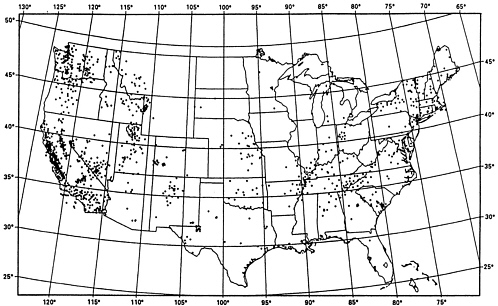
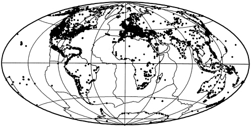
An example of the first area is the USGS effort in earthquake monitoring, assessment, and research. The U.S. earthquake monitoring and basic research system is supported and operated by the USGS and the NSF-funded Incorporated Research Institutions for Seismology (IRIS) in collaboration with university and other partners. This system includes a large number of stations, including the USGS's National Seismic Network (NSN) broadband stations, that are used to monitor earthquakes in the seismogenic regions of the United States and typically involve digital recording, continuous telemetry to central processing sites, and automated arrival detection and earthquake location procedures (Figure 4.1). This national effort is part of a larger international effort that includes thousands of seismic stations that contribute data to the International Seismic Center (ISC) (Figure 4.2). A major objective of the national and international monitoring systems is the rapid location and analysis of earthquakes for emergency response and hazard mitigation. As an earthquake monitoring agency, the USGS's National Earthquake Information Center needs to acquire data in near real time to provide rapid assessment of international earthquake disasters to the State Department, which must deal with U.S. interests regarding disasters around the world. The USGS interest in global earthquake monitoring is also stimulated by the fact that the worldwide study of earthquakes is an effective way to understand the nature of these phenomena and the natural hazards within the United States (NRC, 1995b).
Natural disasters are a growing concern nationally and internationally (GDIN, 1997). In the United States, natural disasters occur nearly everywhere and include earthquakes, volcanic eruptions, landslides, floods, tornadoes, and hurricanes (Figure 4.3). The provision of accurate, timely, integrated information from the USGS and other sources can be used to reduce losses from natural disasters. The USGS is encouraged to play a stronger role in the disaster information community in the future than it has in the past. The USGS has the responsibility to monitor
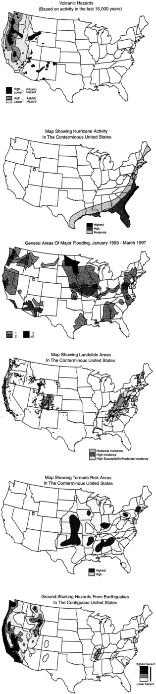
and issue warnings for earthquakes, volcanic eruptions, and landslides, as well as to monitor floods. It also has the responsibility to make disaster-related information available to disaster managers. Although disaster managers are finding it easier to obtain and share relevant information than in the past because of the Internet, data formats and reliability as well as accessibility remain problematic. The USGS, as the recommended portal for integrated digital natural science data, is urged to provide national leadership in this area. For example, the agency already has Global Disaster Information Network (GDIN)-type prototype networks and could easily become the lead player.
The USGS should maintain and enhance its leadership in the area of assessing resources. For many years, the USGS has provided assessments of energy, mineral, and water resources and, more recently, of biological resources as well. Previous NRC reports have praised the USGS for the comprehensiveness and relevance of its energy, mineral, and water resource investigations and provided strategic guidance for the future of these activities (NRC, 1991, 1996a, 1999d). For example, the 1999 review of the USGS Energy Resources Program “found the 1995 domestic oil and gas assessments to be effective, of high quality, and a substantial improvement over previous assessments” and commended the Energy Resources Program “for its productive consultations with states and industry and for the innovative methods to disseminate the results (NRC, 1999d). The same report observed that the data compiled in the USGS's world oil and gas assessments “are much in demand. Both federal agencies and energy companies have found its products to have significant value” (NRC, 1999d). It also encouraged “the Energy Resources Program to evaluate whether the effort on world energy resource assessment and supporting research should be increased above present levels” (NRC, 1999d). Since the publication of the report, the USGS has released its world oil and gas assessment for 2000, which is based on geology and statistical analysis. Resource assessments— energy, minerals, water, and biological resources—comprise critical information that should be provided by a federal science agency. As the United States progresses into the twenty-first century, natural resources essential to the economic and strategic security of the nation will be subject to much greater pressures than in the past. By providing national leadership in offering natural resource information, the USGS will help the United States understand its future natural resource needs.
INTERNATIONAL ACTIVITIES
Many of the current and emerging science challenges discussed in Chapter 3 are not the province of any one nation. They are global and international in nature. To address these challenges in the twenty-first century, the USGS is encouraged to play a stronger international role, on behalf of the United States, in order to accomplish its mission. The committee believes that the importance to the United States of USGS international activities and collaboration cannot be overstated.
The USGS, which has been operating internationally for more than 100 years, defines its role in the international arena in terms of promoting U.S. national security and policy interests, furthering U.S. private aspirations in the global economy, addressing global environmental interests, and improving the utility or effectiveness with which the USGS carries out its fundamental domestic mission. Specific examples of USGS activities for each of these four categories follow.
Role in U.S. national security and foreign policy interests:
-
Providing information and technical assistance in responding to catastrophic earthquakes, landslides, volcanic eruptions, floods, and droughts in foreign countries.
-
Providing technical assistance in the assessment of biological, water, energy, and mineral resources; and the development of data and information standards and regional data-sharing networks—recent examples include water resource assessment in Abu Dhabi; coal exploration in Pakistan and Armenia; petroleum geology in Russia and Ukraine; mineral assessments in Bolivia, Venezuela, and Costa Rica; a famine early-warning system for Africa; and the Inter-American Biodiversity network.
-
Using scientific cooperation to create nonthreatening environments to facilitate communication and negotiation between hostile parties—examples of facilitation include the Regional Water Data Banks Project (Israeli-Palestinian-Jordanian water agencies) in the Middle East peace process (Sidebar 4.5) and communal activities between Turkish and Greek Cypriot water managers.
-
Conducting studies to control the spread and reduce the impacts of nonnative invasive plants, animals, and pathogens that have been
-
intentionally or accidentally introduced from foreign countries into the United States.
-
Providing technical assistance to international organizations in documenting, managing, and integrating biological data and information.
-
Coordinating multilateral data sharing projects to ameliorate regional conflicts through the sharing of data and scientific expertise— examples include support provided to the U.S. State Department's Nile River Basin working group, and the Peace Through Seismology project, which coordinates seismology data sharing among countries in the eastern Mediterranean region.
-
Providing expertise in the application of National Technical Means to address relevant national security issues.
-
Conducting global assessments of energy and mineral resources.
-
Maintaining and providing information and data from the Global Seismographic Network, a critical element in the Comprehensive Test Ban Treaty strategy (NRC, 1995b).
Role in furthering U.S. private sector aspirations in the global economy:
-
Introducing and encouraging the use of U.S. equipment, methodologies, and software.
-
Building regional and global databases of energy and mineral resources.
-
Encouraging the release of data on energy and mineral deposits, geologic and topographic maps, and hydrologic data by foreign governments.
-
Facilitating contacts between U.S. companies and foreign counterparts.
-
Developing and disseminating standards and procedures for data and information processing and distribution, mapping, and hydrologic and geologic data collection and processing.
-
Releasing U.S.-produced maps and data from foreign projects for potential use by the U.S. private sector.
Role in addressing global environmental issues:
-
Developing global reference databases for use by climate modelers and other researchers investigating regional and global environmental trends. These include global digital elevation models (DEMs), as well as global databases for landcover, geology, drainage basin boundaries, ecosystems, soils, glaciers, and vegetation.
-
Conducting studies of historic climatic and ecological changes in the geologic record to help understand the possible consequences of future climate change in ecosystems at different latitudes.
-
Representing the U.S. government in organizations such as the International Hydrologic Program and Mineral Deposit Modeling Program of UNESCO (United Nationals Educational, Scientific, and Cultural Organization), Inter-American Dialogue on Water Management, International Union of Geological Sciences, International Geographical Union, International Union of Biological Sciences, the International Union of Geodesy and Geophysics, International Society for Photogrammetry and Remote Sensing, the International Cartographic Association, and the International Quaternary Association.
Role in improving the utility or effectiveness of the USGS's domestic mission:
-
Obtaining scientific knowledge, insights, and data needed by domestic programs, such as knowledge of hydrologic, geologic, and biologic systems and phenomena, as well as mapping, remote sensing, and GIS technologies.
-
Developing a better understanding of hazards (e.g., earthquakes, volcanic eruptions, landslides, floods).
-
Coordinating studies to support increased cooperation in managing migratory species (e.g., migratory birds, anadromous fish, Arctic mammals, sea turtles), nonnative invasive species, and shared (transborder) ecosystems.
-
Participating in international scientific professional societies.
-
Adding to the knowledge and skills base of USGS scientists.
-
Allowing comparisons of sites and situations within the United States to those in other parts of the world.
-
Adding to the international and domestic stature of the USGS.
As the above examples illustrate, international activities of the USGS are designed to enhance domestic USGS programs and contribute to global knowledge and understanding of natural science problems. They also contribute technical assistance, technology transfer, and education. Given the increasing international and global nature of many natural science problems, there will be more opportunities in the future than in the past for the USGS to pursue international collaborative initiatives. Also, given the increasing international and global importance of natural science problems, the committee believes that the USGS should devote more resources to international efforts in the future than it did in the past.
FUTURE RESEARCH OPPORTUNITIES
The major societal trends outlined in Chapter 3 present many opportunities for the USGS to help the nation solve complex problems. Several recent NRC studies address research opportunities in
|
SIDEBAR 4.5 The Water Resources Division and International Hydrologic Issues Activities addressing hydrologic issues are currently under way in 20 countries in the Middle East, Central America, South America, northern Africa, Asia, and the western Pacific. The WRD's expertise and high level of credibility are principal reasons for requests for help from the international community. For example, the WRD was asked to work with Israeli, Jordanian, and Palestinian water agencies in resolving difficult water allocation issues (NRC, 1999f). Through its expertise in hydrologic data network design and data management, the USGS has become a trusted facilitator in openly exchanging previously sensitive water data among all contentious parties. The project has been one of the few lasting successes of the Middle East peace process and shows how science can promote common understanding and reduce international tensions. |
the environmental, hydrological, and earth sciences that may be of interest to the USGS as it plans its future science directions. These studies include Our Common Journey: A Transition Toward Sustainability (NRC, 1999b), Global Environmental Change: Research Pathways for the Next Decade (NRC, 1999j), and Grand Challenges in Environmental Sciences (NRC, 2000c). More specialized studies include Hydrologic Science Priorities for the U.S. Global Change Research Program: An Initial Assessment (NRC, 1999c), Basic Research Opportunities in Earth Science (NRC, 2001), and Envisioning the Agenda for Water Resources Research in the Twenty-First Century (NRC, in preparation).
Instead of developing a long list of research opportunities, the committee identifies the following topics, grouped around the USGS 's three major themes, which are regional to national in scale and coincide with the scientific mission and capabilities of the USGS. The committee intentionally has not prioritized these topics.
Hazards:
-
Effective hazard information for communities in high-risk environments
-
Hydrologic processes and hazards
-
Wildfires and public policy
Environment:
-
Global climate change
-
Climate variability and water resources
-
Links between geologic processes and human health
-
State of the nation's ecosystems
-
Restoration of aquatic ecosystems
-
Investigations to support wise urban development in the West
Natural resources:
-
Life cycles of ore materials
-
Geologic frameworks for transition to a methane fuel economy
Short discussions of how the USGS can contribute to each broad topic follow. Because the USGS must plan its own research agenda, these suggestions are intended to be illustrative of the sorts of issues that a future research agenda might embrace.
Hazards
Effective Hazard Information for Communities in High-Risk Environments
Because of lack of knowledge, convenience, or economic benefit, a large number of people in the United States and in foreign countries live in dangerous environments. People live on floodplains, in places prone to earthquakes and landslides, and in areas close to active volcanoes. The USGS has programs of high technical quality that define the risks from, and provide disaster information and warnings about, each of these natural hazards. These programs could be strengthened, in budget and personnel, which would provide increased opportunities for enhanced monitoring, for process studies, and for incorporating more social science for risk analysis, economic valuation, and effective education. The disaster management community in the United States and foreign countries would benefit substantially from the results of more comprehensive hazard mitigation studies by USGS scientists.
An example of a USGS program that provides valuable hazard information is the Volcano Hazards Program (VHP), (NRC, 2000b). The VHP has developed investigations of exceptional scientific quality and has maintained enduring, informal links between scientists and decision makers in communities facing imminent risk from volcanic eruptions (Sidebar 4.6). The Volcano Disaster Assistance Program (VDAP) is a cooperative effort of the USGS and the U.S. Agency for International Development (USAID)/Office of Foreign Disaster Assistance to assess and monitor volcano hazards. An outstanding example of the success of VDAP occurred in the Philippines during the Mt. Pinatubo eruption of 1991. A prompt effective response on the part of the VDAP team placed scientists with expertise in monitoring and interpretation at the disposal of the Philippine government. Working side-by-side with Filipino volcanologists, USGS scientists provided accurate and effective warnings that saved thousands of Filipino lives and millions of dollars of U.S. military equipment.
In the United States, natural events such as hurricanes and earthquakes have cost numerous lives and billions of dollars in property damage during the last decade. Disaster losses are reduced when people at risk take appropriate action based on the best information available. As more people, infrastructure, and investment continue to concentrate in high-risk areas (e.g., the coastal zone), it is important for the USGS, as
one player in the broad disaster community, to develop detailed hazard maps for every town and city in the United States. Strong coordination with other players such as other federal agencies (e.g., NOAA), state and local agencies, universities, and many private organizations is encouraged. The hazard maps will be helpful to the Federal Emergency Management Agency (FEMA), which leads the federal response to major disasters, as well as to other disaster managers and planners.
|
SIDEBAR 4.6 Communicating Hazard Information Effectively: Volcanic Unrest in Long Valley, California The eastern Sierra Nevada town of Mammoth Lakes lies inside the 15-by 30-km Long Valley caldera, one of the largest in the United States. The caldera is crossed by young rhyolite lava domes, craters, and open fissures. The most recent eruption occurred 250 years ago. In May 1980, earthquake swarms associated with a 25-cm uplift of the caldera floor aroused concern in the area. Establishment of leveling lines and a larger seismic network affirmed that the uplift and earthquakes could possibly be associated with magma ascent. Geoscientists debated the possibility of an eruption. Meanwhile, angry residents, worried about losing business and declining real estate values, began to threaten the scientists. The poor communication skills of the scientists and poor understanding of geologic processes by the residents caused the confrontation. From the early 1980s to the late 1990s, during another period of geologic unrest, communications improved between USGS scientists and the public. During this period of personal contact, geologists became well known in the community, and they increased public understanding of the potential risks of an eruption. A color code was established for ranking activity levels, ranging from “green” for no immediate risk to “red” for an eruption in progress. In addition, a Web site provided real-time geophysical data, explanations of volcanic activity, and a history of volcanic activity in the area. Years of constant contact built trust between USGS scientists and members of the public. |
Hydrologic Processes and Hazards
The nation's inhabited river floodplains are susceptible to large monetary losses through flood damage to land and infrastructure. They are also vulnerable to losses of ecosystem functions and other environmental values that are either destroyed or withheld as a result of society's attempts to reduce economic losses. Presently, most USGS investigations of flood-prone valley floors are focused on the refinement of the definition of the flooding hazard. This role is valuable, enabling the agency to serve the nation with assessments and information. Because of the refractory nature of the conflict between flood hazards, society 's determination to maximize the use of floodplains, and the increasing value placed on floodplain ecosystem functions, there is an urgent need to broaden the nature of investigations of inhabited floodplains.
Therefore, a good opportunity exists for the USGS to link its hazards and environment research themes. Typically, hazards are viewed as “unpreventable natural events that ... expose our Nation's population to risk of death or injury and may damage or destroy private property, societal infrastructure, and agricultural or other developed land” (USGS, 2000a). However, hazards are also natural occurrences that play a role in preserving environmental health. Trying to understand and manage the human impacts of hazards without a holistic understanding of the environmental role of hazardous landscape shaping processes can be counterproductive (NRC, 1999g). Floods “can be extremely dangerous natural events, leading frequently to loss of life and property,” yet they also help “to maintain the high levels of biodiversity that are characteristic of riparian ecosystems, replenish fertile agricultural soils ... and transport sediment necessary to maintain downstream delta and coastal areas” (Haeuber and Michener, 1998). Thus, policies and practices aimed at limiting flood losses can have adverse effects on riparian ecosystems that are costly over the long term from economic and environmental standpoints.
If policy decisions about natural hazards are to be beneficial over the long term, hazards must be treated as processes that occur within natural systems that include society, not as discrete events that act on human society. In this view, the scientific approach to hazards must be unified. The diversity of scientific expertise at the USGS presents an opportunity to achieve this unification. For example, flood management practices on
alluvial valley floors are often inadequate because research and application of knowledge have been fragmented among disciplines and agencies. The USGS has the capability to conduct an integrative study of the hydrology, biology, and engineering that affect the conditions of valley floors as a basis for developing analytical and planning tools for decision making about land use, habitat preservation, and water quality (Sidebar 4.7). A comprehensive, multidisciplinary analysis of an appropriate floodplain could lead to the recognition of general principles applicable to both hazard and water resource management. Integrating studies of hazards and environmental processes is beneficial because it can provide valuable information. This information can lead to improved emergency response, preventive planning and zoning, reduction of and limits to financial impacts and liability, education and protection of the public, and rehabilitation of many valued landscape functions.
|
SIDEBAR 4.7 Grand Canyon Controlled Flood When Glen Canyon Dam was closed in 1963, the Colorado River through the Grand Canyon began to change (NRC, 1987). There was an increase in riparian vegetation, especially the nonnative riparian tree tamarisk. Water temperatures no longer exhibited strong seasonal variations and became nearly constant at 8°C. Nonnative fish became more abundant, especially rainbow trout. An endangered native fish, the humpback chub, was in jeopardy. The river water became autotrophic instead of heterotrophic. A change also occurred in the geomorphology of the canyon shores and debris flow deposits that localize the major rapids (Webb et al., 1999). At 6:15 MST on March 26, 1996, the U.S. Secretary of the Interior initiated the first experimental controlled flood in the Grand Canyon of the Colorado River. The controlled flood was meant to recreate the Colorado River's seasonal floodwaters that in the past prevented growth of vegetation on the channel banks, deposited sandbars, and eroded boulder deposits in the main channel left by flash floods in tributaries. Over the next seven days, Glen Canyon Dam released 45,000 cubic feet of water per second (USGS, 2000b). The event was a scientific experiment to determine the possible use of floods as a river restoration technique. |
|
The March 26 experiment was made possible through a partnership of three divisions of the USGS and the BIA, USFWS, USBR, NPS, several academic institutions and Native American tribes, and the Arizona Game and Fish Department (Schmidt et al., 1998). USGS scientists created models of experimental flood discharge that convinced opponents that the experiment would work. In other words, the discharge would cause little harm to archaeological sites and existing protected species of animals and plants, would have beneficial effects on river recreational use, and would help control the invasion of some nonnative species. The important role of USGS scientists cannot be overstated. They developed simulations of potential flood effects, conducted experiments based on well-crafted hypotheses, collected data, and formulated management questions before the experiment began. Their activities were closely coordinated with interested parties. The level of water release was not as high as the natural floods of the Grand Canyon in the past. As a result, the restructuring of the geomorphic surfaces was not overly dramatic. However, most of the predictions made by the scientists before the release turned out to be accurate, and virtually none of the consequences feared by some stakeholders occurred. In the end, as one scientist said, “The most important aspect of this project was that it happened at all” (Webb et al., 1999). This example illustrates the ability of the USGS to provide integrative science information and to cooperate constructively with stakeholders. It also shows how single projects involving multiple disciplines can deal with a variety of topics of general interest to the public such as endangered species, unwanted domination by nonnative species, habitat restoration, and water chemistry. In the future, the USGS will be called upon more often than in the past to conduct such complicated integrative studies. |
Wildfires and Public Policy
Fire is an essential element of forests, shrublands, grasslands, and riparian systems and exerts a significant influence on numerous ecosystem functions (Pyne, 1982). Fire recycles nutrients, reduces biomass, influences insect and disease populations, and is the principal change agent affecting vegetative structure, composition, and biological diversity. Fires naturally reduce the amount of undergrowth and debris,
allowing trees to grow taller and healthier. Smaller periodic fires reduce the intensity and magnitude of wildfires by reducing the accumulation of flammable fuels on the forest floor.
Wildfire suppression has changed historic ecological conditions. As humans alter fire frequency and intensity, many plant and animal communities are experiencing a loss of species diversity, site degradation, and increases in the size and severity of wildfires (Ferry et al., 1995). Fire exclusion from suppression efforts has resulted in a lack of periodic, natural fire in America's forests and grasslands. The absence of periodic, low-intensity fires has increased the risk of large, catastrophic fires and has negatively impacted the health of forests and grasslands in the United States.
In 1999, more than 93,000 fires burned almost 5.7 million acres in the United States. Although the number of fires has remained relatively constant over the past several decades, the number of acres burned has over the same period. The 1999 acreage represents a 55 percent increase over the 10-year average. In addition to firefighter fatalities and structures burned, air and water quality was degraded in some areas. The year 2000 has proved to be more devastating. As of September, there had been almost 78,000 fires that burned 6.7 million acres. Federal and state agencies, scientists, local fire chiefs, and others have indicated that the reduction of wildland fuel loadings is essential for reducing threats to property and resources and for restoring and maintaining ecosystem health and productivity. In order to minimize the threat of loss from fires, managers must be able to plan protection strategies that are appropriate for individual areas. A prerequisite for this planning is the ability to assess and map the potential for a major fire to occur.
Fire issues have led to the development of the Joint Fire Science Program, which is a partnership involving six land management and research agencies (USFS, BIA, BLM, NPS, USFWS, and USGS). The program was established by Congress and has a budget of about $8 million. The purpose of the program is to obtain information and tools for managers and specialists making decisions and conducting activities related to wildland fires.
In addition to its involvement in the Joint Fire Science Program, the USGS has several activities related to fire suppression and ecosystem health. For example, as part of the International Program at the EDC, the USGS initiated a fire potential index project to develop a model to assess fire hazard potential. The fire potential index model, which was
developed jointly with the USFS Fire Laboratory, is based on national Fire Danger Rating Systems fuel models, relative greenness of Normalized Difference Vegetation Index from NOAA's Advanced Very High Resolution Radiometer, and 10-hour time lags in fuel moisture. Results suggest that the model is a potentially valuable fire management tool for land managers. The fire potential index is being calibrated for the conterminous United States on a daily basis, and this information is being displayed from the National Interagency Fire Center.
The USGS should play a more prominent role in scientific activities related to fires. Because many fire questions relate to hazards and environmental issues, the USGS should coordinate and lead more of the research needed. For example, the agency could conduct field experiments on the effects of fire on runoff and erosion and could model fire's effects on biota and on the chemical and physical characteristics of soil and water. The USGS could lead the mapping of fuel loads, erosion potentials, and effects on stream water quality and could motivate the exploration of options for management of the hazard through prescription burning.
There will be effects of any fire management strategy, or no strategy, on the condition of forests, as well as on rates of erosion and sedimentation and on water quality. This national-scale issue has components of hydrology, forest and rangeland ecology, soil science, aquatic biogeochemistry, and geomorphology. Addressing the problem also requires palynology, stratigraphy, and geochronology to define spatial and temporal patterns of precolonial forest conditions, and skills in spatial data handling for archiving and modeling. The USGS has all of these capabilities, together with the standing among agencies and Congress, to lead the effort. It could take the initiative to coordinate other agencies and academics to provide policy-relevant information on fires, an environmental management topic of national significance.
Environment
Global Climate Change
Involvement by the USGS in the nation's global climate change research enterprise is marginal, yet global climate change offers an array of scientific and societal challenges that fall within the expertise and
mandate of the agency. Global change is a fundamental tenet of historical geology. The earth is an evolving dynamic planet. The history of global change is preserved in the geological record. As landmasses and oceans of the planet have changed, so too have the climate and character of life on earth. Only by fully understanding the natural changes of the past, can scientists begin to understand the role of humans as an agent of change. For example, the USGS should play a more prominent role in efforts to document anthropogenic influences on climate. The question of the effects of human-caused climate change, especially anthropogenic forcings that are expected to modify the earth's climate (Figure 4.4) (Mahlman, 1997), dominates political and diplomatic agendas, and lies at the forefront of scientific research as well. Detailed climate records covering the last several hundred years are needed to provide a base-line with which to evaluate the effects of anthropogenic emissions on climate. On centennial and millennial time scales, sea surface temperatures in the Sargasso Sea, calculated from oxygen isotopic data and corrected for salinity variations, indicate that variability has been greater than measured over the past four decades (Figure 4.5) (Keigwin, 1996).
Anthropogenic effects on climate can be understood only in the context of knowledge about the undisturbed climate regime; and such knowledge is derived from research in paleoclimatology; paleooceanography; and quaternary geology, including historical geology, geomorphology, and paleontology. The USGS can offer a strong observational and theoretical foundation in these and related fields in order to augment and test the results of coupled GCMs that dominate climate change science. The USGS can also contribute significantly to understanding the multiple causes of climate change, including human contributions from changing land use patterns and natural contributions from volcanism.
The implications of climate change for natural hazards fall squarely in the realm of the USGSs history of work on understanding, monitoring, and mitigating hazards. For example, catastrophic landslides in Nicaragua caused many of the deaths from Hurricane Mitch in 1998. These landslides, in turn, reflect surficial geology and land use patterns that are integral elements of any strategy to protect society against the impacts of climate, whether caused by humans or not. In other words, climate change is much more than a problem of atmospheric dynamics. Yet most research has been focused on understanding how the atmosphere behaves and how it will evolve. Greater USGS involvement
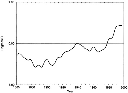
Figure 4.4 Annual global mean temperature for land areas from 1861 to 1997. The curve shows anomalies with respect to the mean temperature for the 30 years 1961-1990. SOURCE: NRC, 1999b, p. 85.
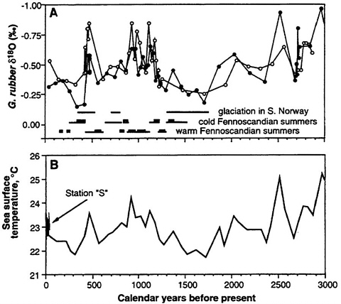
Figure 4.5 Sea surface temperatures in the Sargasso Sea, calculated from oxygen isotope data, indicate greater variability than has been measured over the past for decades. Reprinted (figure) with permission from Keigwin, LD., The Little Ice Age and Medieval Warm Period in the Sargasso Sea. Science 254:1504-1508, 29 November 1996. American Association for the Advancement of Science.
in the nation's climate research program could enhance understanding of the human consequences of climate variability and sensitivity and of the vulnerability of humans to climate variability (NRC, 1999h).
On a larger scale, the combined biological and hydrological expertise at the USGS offers the opportunity to make significant contributions to our understanding of the global carbon, phosphorus, sulfur, and nitrogen cycles. These four elements, along with others, are required for the existence of life. An improved understanding of these cycles is critical if we are to understand how human activities may be modifying the climate system. Today, humans use nearly half of the earth's terrestrial primary productivity, yet scientists do not completely understand the relative roles of biotic and abiotic processes in cycling these elements so that they remain available to living systems (Schlesinger, 1997). The USGS could play a significant role in studies of the cycling of elements critical to life. For a particular example, the USGS is unique among federal agencies in having the personnel and data resources to construct the carbon budget of the nation (including soil, vegetation, and fossil fuel consumption) under current, historical, prehistoric, and projected future land use scenarios.
Greater USGS participation in global climate change research would help to broaden the definition of the problem beyond the current focus on temperature change and atmospheric warming. The focus should be expanded to encompass a range of important issues such as social sensitivity and vulnerability to climate impacts, the influence of land use change on climate, and the value of ecosystem services for societal well-being.
Climate Variability and Water Resources
A central issue about natural and human factors in climate change is its effect on the availability of water in the form of streamflow, lake and reservoir storage, groundwater recharge, and soil moisture in the root zones of croplands and other ecosystems (NRC, 1999c). The nation needs a significant increase in assessments skill for water resource projections, including anticipating the role of interannual and interdecadal climate variations and defining policy-related uncertainties about the influence of climatic variability and secular changes.
A model for this role is the systematic attempt by NOAA to increase proficiency in the economically and socially vital activity of weather prediction, through improvements in monitoring and computing systems, and in collaboration with investigations and model development by agency and academic researchers. By contrast, the terrestrial phase of the hydrologic cycle has never received systematic investigation, and there is potential for updating modeling concepts and methods for predicting various components of the hydrologic cycle (such as soil-moisture patterns, the extent and duration of inundation, and the role of land-atmosphere feedbacks) at the national or major river basin scale. The atmospheric component of the problem is monitored and analyzed by NOAA, and large-scale aspects of the terrestrial phase of the hydrologic cycle are analyzed by academics collaborating with NOAA, NASA, and the USGS. However, there is potential for much larger and more articulated investigations of terrestrial hydrologic processes, including regional droughts and major floods in large river basins. This initiative could involve not only the maintenance of monitoring networks but also organizing field campaigns, assimilating information from earth and atmospheric monitoring satellites and weather forecasts, and development of large-scale mathematical models for assessment of the vulnerability of flood potential, drought, and related regional-scale phenomena. The role of the atmosphere, vegetation cover, and the hydrogeologic properties of landscapes could be integrated by such an effort led by the USGS. This effort could be combined with detailed mapping of topography, ecosystems, land use, and other infrastructure in valley floors to anticipate and monitor the effects of various hydrologic regimes.
The USGS could take on leadership of the broader U.S. water resources community to assess and report as appropriate on the role of hydrology in large efforts such as the Global Energy and Water Cycle Experiment (GEWEX) Continental-Scale International Project (GCIP) (NRC, 1998b) (Sidebar 4.8). This initiative is aimed at improving our understanding of the atmospheric and terrestrial phases of the hydrologic cycle within the Mississippi River Basin and then forging a strong hydrologic component of such national campaigns. The time is appropriate for the USGS to play a stronger collaborative role with NASA, NOAA, USACE, other federal agencies, and the academic community to provide the nation with studies and investigations that improve understanding and predictions of climate-related effects on water resources.
|
SIDEBAR 4.8 Global Energy and Water Cycle Experiment Continental-Scale International Project The GEWEX Continental-Scale International Project is a multifaceted group of NOAA-sponsored activities designed to improve scientific understanding and the ability to model, for climate prediction purposes, the coupling between the atmosphere and the land surface on a continental scale. GCIP activities are focused on the Mississippi River basin to take advantage of the existing meteorological and hydrological networks that are being upgraded with new Doppler radar, wind profilers, and automatic weather stations. GCIP research involves a systematic multiscale approach to accommodate physical process studies, model development, data assimilation, diagnostics, and validation topics. The GCIP Science Plan (World Meteorological Organization, 1992) defines the following objectives:
|
Links Between Geologic Processes and Human Health
Study of the interface between natural sciences and medicine is a nontraditional discipline that has been described by such terms as medical geology and geomedicine (Lag, 1983). A causal relationship between geochemistry and human health is highly plausible because many elements in the earth's crust are essential to our biochemical and physiological function. It is a potentially exciting field of inquiry because proper amounts and balances of several elements may help prevent
disorders now of intense interest, such as some cancers and cardiovascular diseases, developmental defects, and a host of long-term, and therefore age-related, human ills. Critical studies are required to ascertain if particular illnesses such as multiple sclerosis, certain cases of anemia, and Kaschin-Bek disease3 are geomedical problems. The intersection between natural sciences and allied health sciences remains an underexplored field. This intersection should be explored by the USGS in coordination with other agencies such as the National Institutes of Health (NIH).
Marked improvement in human health related to clean drinking water and adequate water for sanitation is a major achievement of public health in developed countries. More recently, increasing attention is being given to the full consequences for human health of large-scale alterations in the biogeochemical cycles of both major elements and trace metals. In addition to health outcomes that may stem directly from polluting substances, there is growing evidence of indirect effects of human-induced changes in the environment on the emergence and spread of disease vectors for Lyme disease, malaria, dengue fever, cholera, yellow fever, and hantavirus. Scientists in the USGS, for instance, have in-depth knowledge of biogeochemical cycles, food chain contamination, and factors that affect water quality and quantity. In addition, they have the expertise that should enable them to investigate complex, interdisciplinary problems that span multiple spatial and temporal scales. They have the capability for spatial data analysis (risk factor mapping) that can be applied in environmental epidemiology for disease cluster analysis. In disaster epidemiology, geological information is needed to understand the proliferation of waterborne pathogens following floods, earthquakes, and disruption of the water supply. Clearly, the USGS has the ability to make important contributions to the study of the health of human communities using established tools in biogeochemistry.
The effects of climate change on human health can be profound— from changes in the quantity and quality of potable water supplies to the spread of vector-borne diseases such as malaria. Changes in the temperature of the atmosphere and earth's surface, as well as the amounts and areal or seasonal patterns of precipitation, probably will result in some regions becoming drier and others wetter (NRC, 1999b). The incidence of floods, storms, landslides, and droughts will change.
|
3 |
A disease of the musculoskeletal and connective tissue that results from consumption of water contaminated with fluoride. |
Many physical processes that can impact the partitioning, distribution, and effects of toxic contaminants and the risk to humans are also susceptible to change in climate. Climate-related changes in the hydrological cycle can, in turn, affect biological systems by changing their productivity, composition, and diversity and food web relationships. The relationships between climate change, geological processes, and human health provide opportunities for holistic scientific investigation.
State of the Nation's Ecosystems
When the BRD was added to the USGS, it expanded the agency's potential to deal with biological issues of importance to the nation. These issues include the assessment of the nation's ecosystems and the scientific basis for ecosystem management. Several critical questions have been posed (Lubchenco et al., 1991):
-
What are the patterns of the diversity of nature and what are their critical ecological and evolutionary determinants?
-
What factors control the sizes of populations?
-
How are changes in population size related to processes mediated at the level of the individual?
-
How does fragmentation of the landscape affect the spread and persistence of populations?
-
How do patterns and processes at one spatial or temporal scale affect those at other scales?
-
What are the feedbacks between the biotic and abiotic portions of ecosystems and landscapes?
-
How do climatic, anthropogenic, and biotic processes regulate geochemical processes?
Interactions among life scientists, geologists, geographers, and experts in surface and groundwater hydrology are required to address these broad questions, as exemplified in a recent NRC report Grand Challenges in Environmental Sciences (NRC, 2000c). Consider the significant ecological consequences of land and water use changes, for example (Sidebar 4.9). Documenting these changes and studying the mechanisms by which such changes influence existing systems are important to the nation 's economy and to the protection of a suite of
|
Sidebar 4.9 Great Lakes Ecosystem The Great Lakes, with a shoreline of more than 10,000 miles, are a major geological feature in North America and an important natural resource. These lakes contain approximately 20 percent of the surface freshwater available on earth and about 80 percent of surface freshwater in North America. Nearly 40 million people live in the Great Lakes watershed, which is one of the more industrialized regions of the country. The demand for high-quality relevant data concerning the health of various components of the Great Lakes ecosystems has risen rapidly in recent years. Billions of dollars and huge resources have been expended in the United States and Canada in an effort to reverse the effects of culturally-induced eutrophication, toxic chemical pollution, overfishing, habitat destruction, and the invasion of nonindigenous species. Environmental managers are being required to demonstrate that past programs have been successful and that a commitment of additional resources Would yield significant benefits. One way to measure the health status of the Great Lakes is to develop a suite of diagnostic indicators that quantify the condition of the ecosystem and identify its primary stressors at local to regional scales. The diagnostic measures can be used to characterize landscape and lake attributes and to derive a range of environmental end points such as watershed quality, nearshore/offshore biological conditions, habitat suitability, and water quality. The USGS operates a regional BRD office with biological stations and research facilities on each of the Great Lakes. This regional laboratory has unique capability for research on fish communities (e.g., community dynamics, life history, trophic level), aquatic habitat (e.g., biodiversity, species biology, ecosystem health assessment), watershed characterization (e.g., fire ecology, species biology, wetland ecology, stream contaminants), and ecosystem modeling. In addition, the USGS's WRD, which has offices in all Great Lakes states, conducts research on local hydrogeologic problems including contaminant hydrology. Although the BRD and WRD make important contributions to solving site-specific problems, little effort has been made to coordinate monitoring and research efforts to provide a basin-wide perspective on the conditions of Great Lakes' ecosystems. A comprehensive ecosystem approach to managing the resource capital of the Great Lake is needed. |
|
In terms of the available expertise and research facilities, the USGS is well positioned to play a key role in multidisciplinary investigations to characterize the Great Lakes as a whole and assess their health conditions. The agency has the tools and expertise to undertake a systematic evaluation of the biological, chemical, and physical processes at multiple scales, ranging from individual communities to the entire watershed. Such a multidisciplinary research program, using integrative indicators, could provide environmental managers and the general public with information about changes to the ecosystems of the Great Lakes as well as probable consequences of changes in environmental end points and likely results of various risk management scenarios. An analysis of trends in environmental measures could provide a perspective on whether conditions are improving or deteriorating, as well as how the lakes are responding to present controls and remedial measures. Integrative, multidisciplinary projects that address the health of Great Lakes ecosystems offer an opportunity for the USGS to play a leading role in the provision of technical advice for the management and protection of this precious natural resource. |
natural ecosystems. The USGS has the capability to play a strong role as a source of information on ecosystems in the future and to capitalize on society's interest in the conservation of biodiversity, the potential effects of climate change, the cause of the invasion and spread of non-native species, and the sustainability of the biosphere.
The national Gap Analysis Program (GAP) provides broad geographic information on the status of species and their habitat in order to provide land managers, planners, scientist, and policy makers with the information they need. Gap analysis is a method for identifying the degree to which native animal species and communities are represented in our conservation lands. This program is sponsored and coordinated by the USGS and is its principal program to assess and map ecosystems across the United States. Presently, GAP is made up of more than 445 contributing organizations in 44 states (USGS, 1997b). These partners include businesses, universities, state and federal agencies, tribes, and nongovernment organizations.
Currently, EPA, USFS, NPS, USBR, BLM, several agencies charged with fisheries and aquatic mammal management, and other agencies deal with issues of ecosystem management. Many scientists of the BRD were
involved with ecosystem management before they joined the USGS. Ecosystem management requires not only biological data, but also geologic and hydrologic data on patterns of physical and biological features, much of which can be obtained using remotely sensed imagery. Clearly, the USGS, through coordinated research, is well suited to assist and, in many cases, to lead such studies.
Restoration of Aquatic Ecosystems
Since the 1970s, the functions of aquatic ecosystems and the value of aquatic systems to society have become better understood and interest in the holistic process of the restoration of aquatic ecosystems has increased (NRC, 1992a, 1995c). Restoration efforts in a part of the Florida Everglades hydrologic-biologic system (Sidebar 4.10) are perhaps the most visible current expression of this national interest, but there are other important restoration efforts under way. Progress is being made to restore the Chesapeake Bay, an economically and ecologically important estuary (CBP, 2000). The CalFed Bay-Delta Program is attempting to improve ecosystem functioning, water quality, water supply, and levee integrity in the Central Valley of California (CalFed Bay-Delta Program, 1999). There is interest in the removal of obsolete dams in the Pacific Northwest that block fish runs and affect the quantity and timing of water flow in rivers as well as flow velocities, water chemistry, and water temperatures (NRC, 1996d). Both of these projects are collaborations of federal, state, and local partners.
Adequate technical information is needed to help guide and assess appropriate responses to these initiatives. A coordinated program of process investigations, monitoring, historical reconstruction, modeling, large-scale experimentation and performance assessment is needed. A federal science agency is necessary for the development of unbiased transferable data, information, and knowledge about aquatic systems. The USGS has the nationwide science infrastructure for this task; the range of technical expertise in terrestrial and aquatic biology, hydrology, sedimentation, and geomorphology; and the capabilities for monitoring, mapping, data analysis, problem solving, and information dissemination, as exemplified by the long-term estuarine study of the San Francisco Bay. Since 1968, the San Francisco Bay has served as an estuarine laboratory for the USGS.
|
Sidebar 4.10 South Florida Restoration Project The Florida Everglades is the largest single wetland in the contiguous United States, covering an area of 1.5 million acres and extending from near Orlando in the north to Florida Bay in the south (Davis and Ogden, 1994). Since the mid-1800s, fully half of the Everglades has been drained and converted to agriculture and urban uses, and intense human activity has altered the remaining wetland. These alterations have been caused chiefly by diversion of water for human uses, reduction of water flows to protect against floods, increase to the nutrient supply of wetlands by runoff from agricultural fields and urban areas, and invasion of nonnative or otherwise uncommon plants and animals that outcompete native species. Populations of wading birds, including some endangered species, have declined by 85-90 percent in the past half-century, and many species of South Florida's mammals, birds, reptiles, amphibians, and plants are either threatened or endangered. The present management system of canals, pumps, and levees will be unable to provide adequate water supplies to agricultural and urban areas, or sufficient flood protection, let alone to support the natural, but severely damaged, ecosystems remaining as wetlands. The present system is unsustainable. To meet the needs of increasing population and agricultural demands for water, and to begin the restoration of Everglades aquatic ecosystem to a more natural regime, an ambitious plan called the Central and South Florida Project has been developed by the U.S. Army Corps of Engineers and its local sponsor, the South Florida Water Management District. It was assisted by the South Florida Ecosystem Restoration Task Force, a team of several federal agencies (including the USGS), state and local agencies, and Indian tribes. The USGS has been a catalyst and a major contributor to the science underlying the restorative actions to be taken. The plan to restore the Everglades is ambitious and comprehensive. It entails changing the current hydrologic regime in the remnant Everglades to one that resembles a more natural one, reestablishment of marshes and wetlands, implementation of agricultural best-management practices, enhancements for wildlife and recreation, and provisions for water supply and flood control. It will involve the creation of several large surface and subsurface storage areas to capture much of the water now drained by ditches and canals directly to the Atlantic Ocean or the Gulf of Mexico, the creation of new wetlands to trap agricultural and urban pollutants before |
|
their discharge to the natural wetlands, the supplementation of flows with highly treated wastewater, and an increase and change in the pattern of water releases to the natural wetlands and estuaries, partly by removing artificial barriers to the formerly dominant process of overland sheet flow. Planning for and implementation of the restoration effort requires application of state-of-the-art large systems analysis concepts, hydrological and hydroecological modeling, hydrological and ecological data, sophisticated decision support systems, integration of social sciences, and monitoring for planning and evaluation of performance in an adaptive management context. These large, complex challenges of the greater Everglades restoration effort demand the most advanced, interdisciplinary, and scientifically sound capabilities the nation has to offer. It is likely that this multiple-agency integrated approach to projects of regional and national concern will be a dominant way of doing business in the future (Harwell, 1997; Harwell et al., 1999). The USGS divisions have to develop working relations that foster the continuation of this type of collaboration. The USGS as an entity must be prepared to respond to the complex environmental problems the nation faces now and in the future. |
Investigations to Support Wise Urban Development in the West
For several decades the population in the more arid parts of the western United States has increased faster than the national population growth rate. Rapid population growth is expected to continue and will be accompanied by rising resource consumption and rising requirements for environmental quality and outdoor recreation. This development raises management problems for governments at all levels. Nettlesome problems include the trend of transfers of water from agricultural to urban and industrial uses (NRC, 1992b) and the need to provide clean water supplies in a region that has already begun to face the physical limits of water resources. Alternative plausible scenarios of availability and timing will be necessary, along with innovative investigations of water use and substitution. Not only river flows, but groundwater recharge and snow-pack distributions will have to be investigated, and the ecological effects of further altering water supplies will have to be addressed. Another development is settlement of alluvial fans and debris-flow fans (NRC, 1996e) that results in flood hazard management problems. Urban expansion into fire-prone chaparral and woodland
ecosystems threatens to intensify fire management problems, including both ecological damage and postfire erosion hazards to settled areas (Keeley et al., 1999). Low-density settlement patterns, typical of the West, threaten to eradicate or impoverish large areas of both terrestrial and aquatic habitat.
In addition to water and flooding issues, the USGS should continue its work with state and municipal agencies to evaluate the basic geologic framework of cities. Having a detailed geologic map and a three-dimensional view of a city's geology is crucial for geotechnical evaluations and land use and an idea of the distribution and character of construction materials. Integrated work on urban geology in several southwestern cities is beginning with the STATEMAP program, in which the USGS cooperates with municipalities and states.
The nation needs an integrated research agenda on the sustainable development of lands in the West. These lands will be the focus of conflict because of the environmental constraints on available resources and the changing environmental values of society. The USGS would be shrinking from its responsibilities to “provide science for a changing world in response to present and anticipated needs” if it does not embrace this topic in much the same way that John Wesley Powell sought to provide scientific information for wise development of the West more than a century ago.
Natural Resources
Life Cycles of Ore Materials
One of the great challenges of the coming decades will be to better understand the cycles of material and energy flow and use within the dynamic earth environment. Earth systems are inherently complex (NRC, 1993c) and human activity adds to this complexity. Understanding these systems will require integration across many natural and social science disciplines. Breakthroughs in understanding will often come at the interfaces of disciplines. As a multidisciplinary science agency, the USGS is suited to play a role in advancing functional models of material and energy cycling within the earth's environment.
Investigations of mineral, energy, and water resources have been at the center of USGS activities for more than a century, but these investigations will undergo major changes in coming decades. There will
be decreased emphasis on identifying domestic resources for development and increased emphasis on gathering and interpreting information needed to support the sustainable use of resources. Essential to this changing emphasis will be the development of reliable models, known generally as life-cycle models, that trace the fate of elements and minerals in the environment. Life cycle models of mineral resources document the physical and chemical processes involved in deposit formation, weathering and erosion, mining and processing, commodity use, recycling, and ultimate disposition of mineral commodities.
Mineral deposits are physical and chemical anomalies in the crust of the earth. Whether or not a mineral deposit is developed, it may have an impact on the local environment and ecosystem of an area. Thus, the life cycle of a mineral commodity starts with the formation of a mineral deposit. Genetic mineral deposit models provide an understanding of the character, location, and abundance of the nation's mineral resources. Geoenvironmental models build on these genetic ore deposit models with information that can be used to understand and predict the effects of natural exposure or human development. Mining, processing, and refining provide the interface between the natural mineral cycle and the human use cycle in which mineral products are used, recycled, and ultimately disposed. For many elements, these geochemical cycle models link directly to models relating environmental geochemistry to animal and human health.
The impacts of resource development and use can be diverse, affecting air quality, water quality, stream sedimentation, and soil erosion or contamination. Useful geoenvironmental models must be based on rigorous models of the geochemical, geological, and biological processes involved, as well as on adequate documentation of the natural background character of the nation's lands and waters. Documented national geochemical baselines and backgrounds provide a standard or measure against which future environmental perturbations, natural or anthropogenic, can be compared. Determining geochemical baselines and backgrounds must also be a multidisciplinary endeavor involving geochemists, geologists, hydrologists, and biologists. The USGS, with integrated expertise in the earth and biological sciences, is capable of meeting this challenge.
Geologic Frameworks for Transition to a Methane Fuel Economy
Historical market forces promoting efficiencies, along with current and future concerns of atmospheric quality, are likely to drive the world and particularly the United States to a methane-based economy and eventually to an energy economy based on hydrogen (Williams, 1996; PCAST, 1997; Serchuk and Means, 1997). Several recent estimates of the remaining natural gas resource base in North America, and especially the United States, indicate a volume sufficient to meet the large demands of the methane economy (NRC, 1999d). However, no more than one-third of the expected demand can be met by current reserves, currently projected reserve growth from existing fields, and ready discovery. Adding a sufficient volume of resources to producible reserves will involve discovery in the deeper parts of basins where the geology is known only marginally or in hostile environments, such as ultradeep waters and arctic frontiers. Other sources must come from low-permeability formations where basic understanding of formation variation and fracturing will be required. Increasingly, reserves must be developed from a whole series of emerging resources such as basin center formations, deep deposits of coal bed methane, methane hydrates, and methane in geopressured geothermal waters, all insufficiently known (Collett, 1993; Kvenvolden, 1993; Socolow, 1997). As the natural gas resource base moves from higher- to lower-quality resources, demands for technology and the geologic framework to efficiently deploy new and advancing technology become essential if natural gas supplies are to be available as needed and at affordable prices.
The United States has a substantial geological work force to meet the demands of the methane energy economy—in industry, universities, states, and private research concerns. However, the paramount public interest that will be served by a clean-burning and efficient energy source defines a role for the USGS in collaboration with other partners particularly DOE, MMS, EPA, and the Department of the Navy.
TRANSITION TOWARD AN INTEGRATED NATURAL SCIENCE AND INFORMATION AGENCY
The research opportunities discussed in the previous section all concern complex systems and illustrate a need for the USGS to develop a
strong agency-wide commitment to, and capacity in, integrative science. Because of its information resources, technological capabilities, and range of professional expertise, the USGS is well positioned to pursue integrative science. By evolving into a natural science and information agency, the USGS can meet society's expectations for analytical and integrative science focused on problem solving, rather than on monitoring or knowledge advancement alone (Pielke et al., 1999).
Integrative science focuses on the major issues that cross the narrow boundaries of conventional scientific disciplines and is more than simply an interdisciplinary collaboration, although it may begin there. Rather, integrative science entails individuals sharing different perspectives, methodologies, and conceptual models in a manner that changes each person's approach to the problem at hand. Integrative science is the construction of conceptual models that link causal processes to illuminate the complex interrelationships among physical and biological phenomena (Turner, 1991). Data are a starting point in the refinement, testing, and elaboration of successively more realistic models of natural-and human-driven processes, but the overall goal is to derive and apply a conceptual understanding of these systems to the betterment of human life. Thus, data on streamflows should lead to a holistic understanding of flood dynamics, but may also lead to a better understanding of agricultural productivity, avoidance or mitigation of contamination, and ecosystem dynamics. In other words, the output should be multidimensional and utilitarian.
An integrative approach implies focusing on the nature of the problems in all of their complexity and creating teams with the skills and resources necessary to provide the entire suite of knowledge required for well-informed responses. Developing interdisciplinary teams requires more of management than drawing a committee of scientists from each of the existing USGS divisions to attack a problem. It requires management of the development of the integrative habit of inquiry by knowledgeable individuals. The development of true interdisciplinary teams requires changes in group dynamics, analytical approaches, and types of synthesis activities (Metzger and Zare, 1999). A determination to commit the agency to integrative scientific investigations is not an easy step to undertake. Not only are the objects of study (e.g., fish, trace-element geochemistry, tectonics), and therefore the vocabularies, different among disciplines, but the traditional spatial and temporal scales of phenomena to be studied and the nature of acceptable
explanations are different too, as are scientific methods, criteria of evaluation, and professional culture in general. Thus, integrative work relevant to policy often requires that new perspectives are forged, new applications of methods are developed (perhaps involving unprecedented measurement precision), and greater emphasis is given to the definition of conceptual system models. Despite the difficulties of achieving integrative science even for rather narrowly defined problems, the results can be analyses of unprecedented power and utility and more effective reports and data products. Both the difficulties and the rewards imply that in a large, multifaceted agency such as the USGS, senior management has to take the lead in promoting such integration because they are the only personnel with knowledge of all the agency's resources and they alone are charged with the strategic application of these resources in the overall national interest.
USGS managers should also recognize the opportunity inherent in multiagency (federal, state, tribal, and local) teams. Several recent multiagency studies, such as the ecosystem evaluations of San Francisco Bay and Chesapeake Bay, offer illustrations of both the potential, for integrated science investigation and the commitment to integrated implementation of recommendations.
The committee believes that comprehensive understanding of the types of complex natural science issues described in earlier sections of the report will be difficult to achieve without some substantial degree of disciplinary integration. Thus, the committee recommends that the USGS evolve from an agency organized primarily around disciplines to discover and understand what is out there (surveys, data collection, and data synthesis) to one that is organized to a greater degree around interdisciplinary teams to understand how what is out there works (process understanding). Understanding how the complex air-water-human-land system works calls for scientists to cooperate on studies that encompass a combination of physical, chemical, biological, and social processes.
The USGS was founded around disciplinary skills and experience, and it continues to embrace a discipline-specific organizational structure. Despite this constraint, the agency recognizes the value of interdisciplinary teams and studies, and has demonstrated the importance of these efforts many times. However, it has not yet created an interdisciplinary environment to confront the complexity of the issues at hand. One of the important benefits of USGS ecosystem studies has been
to increase the appreciation by earth system scientists of the interdependence of natural processes with the lithosphere, hydrosphere, biosphere, and atmosphere. Animal life depends upon plant life, which depends upon water and soil, which are controlled by geology and climate. It is impossible to understand any single part of the environment without an understanding of the whole. The USGS has the capability and the opportunity to advance understanding of such interconnected processes, with integrated research teams crossing traditional disciplinary boundaries.
The failure to integrate will inhibit understanding of natural science problems. However, the committee recognizes that integration is difficult to achieve, especially in cases that require integration of physical and social sciences. Because of the gulf between disciplines, efforts to achieve integration are more likely to advance incrementally through the cooperative study of particular problems than through the top-down imposition of a comprehensive framework. All the same, senior USGS management should help to instill an agency-wide commitment to integrative science. Senior USGS management should ensure that appropriate disciplines are brought to bear on problems that require cooperative study for their solution.
SUMMARY
In the twenty-first century, the USGS will be called upon to play critical roles in solving complex problems. To confront these issues, the committee recommends that the USGS evolve into a natural science and information agency. The USGS should exercise national leadership in its areas of primary responsibility and, in view of the international and global nature of many science problems, should increase its international activities above present levels.
Opportunities exist for the USGS to improve service to its multiple audiences particularly by (1) ensuring that science information is provided to DOI departments efficiently and effectively; (2) strengthening liaison and coordination with related federal agencies; (3) maintaining and improving relations with state and regional government organizations and with nongovernmental organizations that are users of science information; (4) facilitating the use of science information by the general public and by stakeholders for critical issues; and (5) increasing
interactions with foreign customers and partners. In light of its strong move toward regionalization to bring the agency's leadership closer to its customers, the USGS should be careful not to assume the role of state or regional organizations.
In the realm of future program emphasis, the USGS should provide national leadership and coordination in such areas as establishing data standards; assessing resources; and monitoring, reporting, and where possible, forecasting critical natural science phenomena. It should give high priority to (1) maintaining and enhancing high-quality, long-term databases; (2) emphasizing the value-added activities of data analysis, information dissemination, and problem solving; (3) establishing an interdivisional program in system modeling and integration; (4) advancing toward a natural science and information integration organization that involves the development of a framework for a geospatial information depository and portal; and (5) conducting monitoring activities more efficiently through the use of advanced technology.
The committee believes that the USGS should, because of its mission, study problems of regional, national, and international importance. It encourages studies that encompass a combination of physical, chemical, biological, and social processes and are thus multidisciplinary and provide opportunities for integrative science. Senior USGS management should ensure that appropriate disciplines are brought to bear on studies that must integrate across disciplines.
The USGS will face administrative challenges as it transitions toward a natural science and information agency. These challenges are the subject of Chapter 5.


