
3
Human Alterations of Riparian Areas
Because humans worldwide now use more than half (~54 percent) of the geographically and temporally accessible river runoff (Postel et al., 1996), it is not surprising that we have had a significant impact on the structure and functioning of riparian areas. Human effects range from changes in the hydrology of rivers and riparian areas and alteration of geomorphic structure to the removal of riparian vegetation. Drastic declines in the acreage and condition of riparian lands in the United States since European settlement are testimony to these effects.
Manipulation of the hydrologic regimes that influence the physical and biological character of riparian systems has often occurred via the construction of dams, interbasin diversion, and irrigation. As discussed below, these activities disconnect rivers from their floodplains. A second major impact is related to the initial harvest of riparian areas, followed by subsequent conversion to other plant species via forestry, agriculture, livestock grazing, residential development, and urbanization. The removal of streamside vegetation not only removes the binding effects of roots upon the soil, but also causes a reduction in the hydraulic roughness of the bank and an increase in flow velocities near the bank (Sedell and Beschta, 1991). Such situations invariably lead to accelerated channel erosion during subsequent periods of high flow. Although degradation of native riparian plant communities by forestry, agriculture, and grazing can often be reversed, other practices such as drainage modifications and structural developments in urban areas generally lead to irreversible changes in riparian areas over long time periods.
The impacts to riparian areas are manifested in the quality of adjacent waterbodies throughout the United States. Only about two percent of the nation’s streams and rivers are classified as having high water quality (Benke, 1990). A 1998 summary of polluted waters for all 50 states indicates there are more than 300,000 miles of rivers and streams and more than 5 million acres of lakes that do not meet state water-quality standards (EPA, 2000).
HYDROLOGIC AND GEOMORPHIC ALTERATIONS
Throughout history, societies have sought to regulate water resources. Today, over three-fourths of the 139 largest river ecosystems in the northern third of the earth are strongly or moderately fragmented by dams, interbasin diversions, and irrigation (Dynesius and Nilsson, 1994). In the contiguous 48 states, all large rivers greater than 1,000 km in length, except the Yellowstone River of Montana, have been severely altered for hydropower and/or navigation, and only 42 free-flowing river segments greater than 200 km in length remain (Benke, 1990). Disconnection of river systems from their historical floodplains is a severe problem worldwide about which there is limited but growing understanding (Naiman and Décamps, 1990).
Changes in natural hydrologic disturbance regimes and patterns of sediment transport include alteration of the timing of downstream flow, attenuation of peak flows, and other effects. Such alterations can result from dam construction, from transbasin diversions, or by water removal from rivers for irrigation or other consumptive uses, often in combination. For example, along the mainstem Columbia River in the Pacific Northwest, snowmelt peak flows have been suppressed by upriver storage facilities and the management of the river system for both power generation and flood control (NRC, 1996). Similarly, the Willamette River in Oregon has a reduced frequency of overbank flows, disconnected side channels, and greatly reduced potential for maintaining riparian and floodplain forests because of extensive bank stabilization and dam construction (Figure 3-1). Box 3-1 gives an example of the effects of various hydrologic manipulations on riparian plant communities and ecosystem processes in the arid Southwest.
The following sections discuss the specific effects of dams, bank-stabilizing structures, levees, and groundwater withdrawal on riparian structure and functioning. The extent to which downstream riparian areas are affected by these changes depends upon the degree of flow and sediment alteration plus the capability of the riparian plant communities to respond to these changing environmental conditions.
Dams
The vast majority of dam building and associated water resources development in the contiguous United States occurred during the middle portion of the
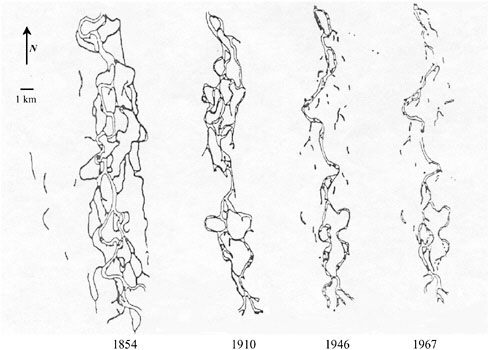
FIGURE 3-1 Channelization of the Willamette River since the 1800s has reduced channel complexity, riparian trees, and off-channel habitat. SOURCE: Reprinted, with permission, from Sedell and Froggatt (1984). © 1984 by Science Publishers.
twentieth century—an extremely short time period compared to the many thousands of years over which riparian plant communities have adapted to shifting climatic regimes, runoff patterns, and adjustments in channel morphology. There are currently 75,000 dams on the streams and rivers of the United States (Meyer, 1996; Graf, 1999), and large dams1 worldwide are being completed at an estimated rate of 160 to 320 per year (World Commission on Dams, 2000). Dams have been constructed for hydropower generation, irrigation, flood control, domestic and industrial water use, recreational use, improved navigation, or some combination of these uses. Although detailed methods for the design of dams (e.g., Bureau of Reclamation, 1977) have been available for many years, such methods have provided little or no context for understanding the potential impacts such structures might have on other portions of a river and its riparian system.
|
1 |
A large dam is 15 meters or more high (from the foundation). A dam 5–15 meters deep with a reservoir volume over 3 million cubic meters is also classified as a large dam. Using this definition, there are more than 45,000 large dams worldwide. (World Commission on Dams website:www.dams.org) |
|
BOX 3-1 The effects of hydrologic manipulation on riparian area functioning have been particularly well documented along the middle Rio Grande (Shaw and Finch, 1996; Molles et al., 1998). Historically, the middle Rio Grande was a flood-dominated ecosystem. Spring snowmelt from the mountains of southern Colorado and northern New Mexico produced peak discharges between mid-May and mid-June, based on analysis of more than 100 years of flow records prior to impoundment (Slack et al., 1993). As in other floodplain systems, overbank flooding was an integral component controlling the structure of the riparian forest. Given the relatively frequent flooding of the middle Rio Grande floodplain systems, the riparian area was a complex mosaic of vegetation types, including cottonwood (Populous deltoides ssp. wislizenii), Goodding willow (Salex gooddingii), wet meadows, marshes, and ponds. However, dam construction in the upper basins, river channelization, and water management policies of the twentieth century have cumulatively prevented annual spring flooding in recent decades. For the middle Rio Grande, the last major floods in which large-scale cottonwood establishment occurred were in the spring of 1941 and 1942. Thus, most of the current cottonwood gallery forest reflects a legacy of flooding that occurred over half a century ago. Structural changes in the riparian vegetation have been rapid and well documented. For example, half of the wetlands in the middle Rio Grande have been lost in just 50 years (Crawford et al., 1993). Cottonwood germination, which requires scoured sandbars and adequate moisture from high river flows, has declined substantially (Howe and Knopf, 1991). Meanwhile, invasion by exotic phreatophytic plants such as saltcedar and Russian olive has greatly altered the species composition of the riparian forests within the valley. Native cottonwood stands are in decline in many sections of the river, and the cottonwood-dominated bosque at the Nature Center in Albuquerque has experienced a 40 percent decline in cottonwood leaf litterfall over the past decade (see figure below). Without a change in water management strategies, exotic species are predicted to dominate riparian forests within the next 50–100 years. 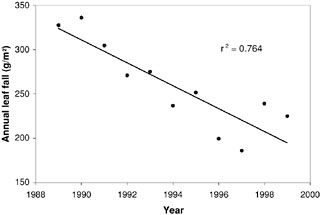 |
The immediate upstream effects of dam construction are obvious—the complete loss of riparian structure and functioning due to inundation, with other important changes in aquatic species, hydrology, and sediment dynamics of the inundated reaches. In particular, wildlife shifts from predominantly terrestrial species and stream-dwelling fish to predominantly lake dwelling fish. The streambank is replaced by extensive and often unstable shoreline in which floodplain vegetation is eliminated. Five percent of the total length of major rivers has been permanently inundated by large reservoirs, essentially removing their associated riparian areas (Brinson et al., 1981).
More recently, attention has been paid to the principal physical alterations of rivers downstream of dams (Rood and Mahoney, 1991). In general, dams reduce the biophysical variability (in flow, temperature, and materials transport) characteristic of rivers, which in turn reduces the biodiversity of both riparian and instream flora and fauna (Stanford et al., 1996). First, with regard to sediment dynamics, suspended sediment (clay, silt, and fine sand) and bedload sediment (coarse sand, gravel, and cobble) transported by a river settle in the slow-moving waters of a reservoir. Although their trapping effectiveness can vary somewhat, most reservoirs are effective at trapping silt-sized and larger particles. If residence times of the stored water are relatively long, large reservoirs may also be effective at trapping clay-sized particles. Over long periods, the channels below a dam can become increasingly “sediment starved,” with a concurrent coarsening of sediments comprising the channel bottom. Following impoundment, a reduction in the sediment load can prevent the regular development of such geomorphologic features as point bars and islands in larger scale rivers, as was demonstrated in the Slave River Delta (English et al., 1997).
Although this is the general paradigm, actual changes depend on local conditions downstream from a dam. For example, if high flows have been suppressed by an upstream dam, sediment-laden tributaries that enter a river below the dam may cause large amounts of sediment to accumulate in the main river. In essence, a loss of river transport capacity due to flow modifications by the upstream dam encourages incoming tributary sediments to accumulate over time.
A second category of downstream alteration is related to the pattern of river flow, where the magnitude of such effects is largely dependent upon the degree of hydrologic alteration created by the dam. Dams that are used only for flood control and hydropower generation may not significantly diminish the amount of water available to downstream channels, although these structures can have a major effect on the overall flow regime (the frequency, magnitude, and temporal distribution of flows). For example, flood-control dams that store water during periods of peak runoff for later release will dampen the magnitude of high flows that would occur normally and increase the duration of moderate flows. Large flood-control dams can effectively accomplish this goal over a wide range of peak flow magnitudes (although the effectiveness of a given dam for dampening downstream peaks tends to diminish with increasingly larger precipitation events).
Other dams may dewater downstream reaches, such as when diversion structures are used to withdraw water to meet local irrigation or other consumptive uses (e.g., Stromberg and Patten, 1990). Although diversion structures are often relatively small in size and may pass high flows essentially unhindered, some are capable of diverting the entire flow during periods of moderate to low flow. In some cases, diverted waters become part of a system of transbasin diversions that may carry water long distances via tunnels, canals, or natural channels to desired locations (e.g., irrigated agricultural lands, municipalities). Structures that divert significant volumes of flow reduce the amount of water available to downstream riparian plant communities.
Dams that have perhaps the greatest effects upon downstream flow regimes are those that have both large storage capacities (relative to runoff amounts) and are used primarily for supplying irrigation water. Because these structures can effectively store large volumes of flow for consumptive use, they can create significant decreases in downstream flows for long time periods and over the entire range of flow magnitudes.
Clearly, the size of a dam and factors governing the storage and release of water (e.g., operational policies, physical constraints on the amount of water that can be released) determine the potential impacts of individual dams on downstream riparian systems. A type with minimal impact would be a “run-of-the-river” dam, such as a low-head hydroelectric dam. Although this type of structure might be used to generate hydropower locally, it would not result in the diversion of flows out of the channel system for use elsewhere. Such a structure might have little effect on the frequency, timing, magnitude, or duration of flows relative to those of an undisturbed or unregulated flow regime. If the run-of-the-river structure also passes sediment, effects upon downstream riparian systems might well be insignificant. In contrast, dams that store relatively large volumes of water relative to the amount of flow from a drainage basin have the potential to significantly alter the character of downstream riparian areas.
The characteristic flow regime and sediment dynamics of lakes can also be vastly altered by dam construction. For example, Flathead Lake in Montana has undergone substantial reconfiguration of its shoreline since construction of a dam at its outlet in 1935. Prior to impoundment, the natural flow regime was shortterm elevation of lake level followed by recession to base elevation. Thus, the natural shoreline was well adjusted to the wave energy generated by the lake, and the shoreline was naturally armored with rocks and gravel deposited over hundreds of years since the glaciers that formed the lake retreated. Current dam regulation, however, maintains the lake above the natural armor, such that wave energy must be dissipated in the soft laucustran sediments laid down immediately after glacial retreat. Especially during storms, this wave action has led to erosion of the lake shoreline as well as erosion of the delta where the Flathead River flows into the lake (Lorang et al., 1993a,b; Lorang and Stanford, 1993).
Only relatively recently have scientists attempted to address the hydrologic
linkages between dam-altered flows and their effects on riparian plant communities (Nilsson et al., 1997). The reduction in the magnitude of peak flows and the increase in duration of low flows brought about by some dams is expected to lead to a shift in the dominant riparian vegetation types, as was shown along the Roanoke River in North Carolina (Townsend, 2001). Clearly, impoundments that reduce overall flows (often leading to concomitant lowering of the water table) will induce stress in riparian vegetation, as evidenced by reduced plant abundance and growth rates (see Table 3-1). Furthermore, studies of riparian forests in the northern Great Plains of Canada indicate that cottonwood establishment is dependent upon (1) high flows that precede seed release, (2) flow recession that permits establishment at appropriate streambank elevations, (3) gradual flow decline for seedling survival following the springtime snowmelt peak, and (4) an absence of floods in the following years (Rood et al., 1999). It is not surprising then that substantial declines of riparian forests have been primarily attributed to dams that alter hydrologic disturbance regimes. For example, Rood and Mahoney (1990) found that dams contribute to the loss of riparian forests by reducing downstream flows or by altering flow patterns to attenuate spring flooding or stabilize summer flows. More recently, Friedman et al. (1998) investigated the effects of dams upon channels and riparian forests in the Great Plains of the United States. The principal response of braided channels to an upstream dam was channel-narrowing accompanied by a one-time “burst” of establishment of native and exotic woody riparian pioneer species on the former channel bed. In contrast, the principal response of a meandering channel to an upstream dam was a reduction in the channel migration rate and a decrease in reproduction of woody riparian pioneer species. Dykaar and Wiggington (2000) have similarly concluded that dams, in combination with other factors such as channel rip-rap, streamside logging, and instream gravel mining, have so altered the fluvial-geomorphic regime of the mainstem Willamette River of Oregon that riparian cottonwoods are currently regenerating at a small fraction of historical levels. Table 3-1 summarizes the types of deleterious effects that dams can have on downstream cottonwood forests in western North America. The hypothesized effects of dams on both upstream and downstream reaches are shown in Figure 3-2.
Bank-Stabilizing Structures
A variety of structures—revetments and rip-rap, gabions, groins, and jetties—have been used to stabilize streambanks. Directly and indirectly, they have influenced the characteristics of riparian areas. Large rock is often placed to provide stability to a streambank and prevent ongoing bank erosion. Such structures may be employed continuously (i.e., along the entire bank) or intermittently along a bank (i.e., at specific locations of concern). An extensive literature survey (Keown et al., 1977) found that the vast majority of published information on
TABLE 3-1 Impacts of River Damming on Downstream Cottonwood Forests in Western North America
|
Impact |
River |
Region |
Populus |
Reference |
|
Reduced forest or tree abundance |
Various |
Arizona |
P. fremontii, P. angustifolia |
Brown et al. (1977) |
|
|
Colorado |
California |
P. fremontii |
Ohmart et al. (1977) |
|
|
South Platte |
Colorado |
P. deltoides |
Crouch (1979) |
|
|
Missouri |
Montana |
P. deltoides |
Behan (1981) |
|
|
Owens |
California |
P. fremontii |
Brothers (1984) |
|
|
Rush Creek |
California |
P. balsamifera |
Stine et al. (1984) |
|
|
Milk |
Alberta/Montana |
P. deltoides |
Bradley and Smith (1986) |
|
|
Bighorn |
Wyoming |
P. deltoides |
Akashi (1988) |
|
|
St. Mary, Waterton, and Belly |
Alberta |
P. deltoides, P. balsamifera, P. angustifolia |
Rood and Heinze-Milne (1989) |
|
|
Arkansas |
Colorado |
P. deltoides |
Snyder and Miller (1991) |
|
Fewer seedlings or absence of seedlings |
Missouri |
North Dakota |
P. deltoides |
Johnson et al. (1976) |
|
Colorado |
California |
P. fremontii |
Ohmart et al. (1977) |
|
|
|
Missouri |
Montana |
P. deltoides |
Behan (1981) |
|
|
Sacramento |
California |
P. fremontii |
Strahan (1984) |
|
|
Salt |
Arizona |
P. fremontii |
Fenner et al. (1985) |
|
|
Rio Grande |
New Mexico |
P. fremontii |
Howe and Knopf (1991) |
|
Reduced tree growth, smaller leaves, and reduced transpiration and water potential |
Missouri |
North Dakota |
P. deltoides |
Johnson et al. (1976) |
|
Bishop Creek |
California |
P. fremontii, P. balsamifera |
Smith et al. (1991) |
|
|
Tree growth and survival determined by river flow |
Bishop Creek |
California |
P. fremontii, P. balsamifera |
Stromberg and Patten (1991) |
|
SOURCE: Adapted from Rood and Mahoney (1991). |
||||
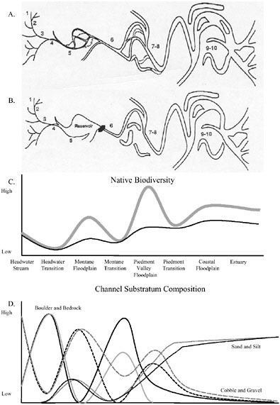
FIGURE 3-2 A schematic of the effects of river regulation via dams. (A) Illustration of a large river showing the major alluvial reaches from the headwaters to the ocean. (Numbers indicate stream order. The figure is not drawn to scale; transition reaches are often much longer than inferred.) (B) Illustration of the same large river after regulation by a high volume, high head-storage dam in the montane transition. (Tributaries downstream from the dam are assumed to be unregulated.) (C) Native biodiversity before (gray) and after (black) regulation. (D) Channel substratum composition before (gray) and after (black) regulation. (Solid lines are boulder and bedrock, broad dashed lines are cobble and gravel, and small dashed lines are sand and silt. The x-axis is the same as in (C).) SOURCE: Reprinted, with permission, from Stanford et al. (1996). © 1996 by John Wiley & Sons, Inc.
streambank protection methods involve such structural approaches as rip-rap, concrete, dikes, fences, asphalt, gabions, matting, and bulkheads; less than 15 percent of the information was directed towards the use of vegetation. Unlike options utilizing vegetation, structural approaches to streambank stabilization can have deleterious effects on riparian areas (Sedell and Beschta, 1991; Fischenich, 1997).
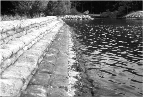
Rip-rap (large rock, pieces of concrete, or other material) remains a common solution for “hardening” a streambank or shoreline in an effort to stem erosion. It is also utilized to stabilize streambanks in the vicinity of bridge abutments, culvert installations, or other features in need of special protection from erosion during high flows. Rarely are the ecological impacts of such projects considered, either for individual projects or cumulatively where multiple projects are implemented. Rip-rap affects the riparian habitat directly by eliminating microhabitats of plant species that naturally stabilize banks. The large pore sizes typically associated with rip-rap treatments seldom contain soil and thus create poor substrates for plant establishment and growth. In addition, because many bank structures reduce the hydraulic roughness (i.e., the frictional resistance to flow) along the channel margins, flow velocities are greater along the bank during high flows, which often precludes the survival of many riparian plant species.
With the loss of riparian vegetation brought about by structural modification of a streambank, important contributions of that vegetation to the aquatic ecosystem (e.g., shading, leaf fall, structural integrity from roots, nutrient inputs) are
reduced, as are its functions as habitat for animals that commonly use streambanks and shorelines. Rip-rap can impede movement of animals that use streambanks and shorelines as migration corridors and destroy nesting areas, as has been documented for the wood turtle (Buech, 1992). Avifaunal studies along the Colorado River showed that, on average, the number of species inhabiting a riprapped riparian area was only about half that of an undisturbed river with intact riparian vegetation (Ohmart and Anderson, 1978).
In some cases, the use of rip-rap can have a deleterious effect on water quality. For example, runoff channels constructed of rip-rap or impervious materials can shunt water from roadways, other impermeable surfaces, or erosionprone areas directly into nearby streams and rivers. Such warmed and often pollutant-laden water enters the river without the benefit of having been filtered by vegetation or soil of the riparian area.
Channelization
Channelization converts streams into deeper, straighter, and often wider waterbodies, making fundamental geomorphic and hydrologic transformations that would not occur under natural conditions. The most common purpose of channelization of small streams is to facilitate conveyance of water downstream so that the immediate floodplain area will not flood as long or as deeply, resulting in reduced soil water content. Channelization is widespread throughout the United
States. Prior to 1970, an estimated 200,000 miles of streams were channelized (Schoof, 1980). In Maryland, 17 percent of all stream miles have been channelized; the Pocomoke River has an estimated 81 percent of its stream miles channelized.
Channelization has the direct effect of destroying riparian vegetation by the actions of heavy equipment or by moving the stream channel to a new location where no natural riparian vegetation exists. Indirectly, channelization impacts riparian vegetation by lowering the water table (Gordon et al., 1992) and otherwise altering riparian hydrology. Because channelization reduces the frequency of overbank flow, the adjacent riparian area becomes drier and the connection between aquatic and terrestrial ecosystems is severed. In addition, channelization often creates a spoil bank next to the newly cut channel that further blocks exchanges between the now-isolated floodplain and the channel. This combination of conditions can eliminate aquatic sites within floodplains, especially high-flow channels and oxbow lakes that would otherwise serve as temporary or permanent habitat for aquatic organisms. Any riparian vegetation left intact during channelization is likely to experience drought stress and eventually be replaced by less flood tolerant species, a phenomenon similar to that which occurs in floodplains below dams (described earlier).
The increased flow capacity afforded by channelization compresses the period of water conveyance, making streams “flashier.” Downstream effects include higher flood peaks and greater loading of sediment, nutrients, and contaminants. Locally, the kinetic energy of water flow is concentrated in the stream channel rather than being dissipated across the floodplain during normal overbank flows. In the absence of streambank stabilization, the channelized reach may undergo a period of accelerated erosion that can lead to additional channel incision or channel widening, or both. Channel incision is of particular concern as it often leads to a headward incision or gullying of the original channel. Thus, the effects of channelization are experienced both upstream (gullying) and downstream (increased sediment production).
Figure 3-3 illustrates the channelization scenario in western Tennessee around the 1900s in which increased channel flow caused streambank erosion and headward channel incision (Hupp and Simon, 1991). An initial stage of headward incision downcutting was initiated by channelization just downstream from the site depicted. After about 50 years, a new geomorphic surface and quasi-equilibrium condition became established. Both bank accretion and regrowth of vegetation were responsible for recovery of the riparian area.
Levees
Levees are large embankments along rivers or other waterways that are designed to not be overtopped during periods of high water and are largely employed for flood-control purposes on land along a stream, river, or other body
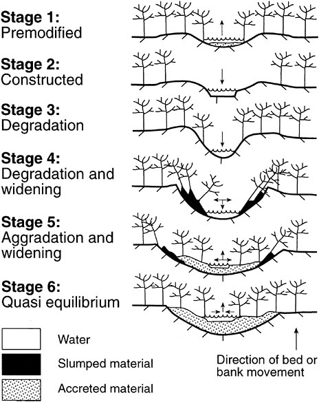
FIGURE 3-3 Stages of stream and floodplain evolution following channelization that occurred in western Tennessee streams around the 1900s. Sites depicted are just upstream from the channelization. Arrows indicate whether aggradation or degradation is taking place. SOURCE: Reprinted, with permission, from Hupp and Simon (1991). © 1991 by Elsevier Science.
of water. Like large dams, large levees are built to eliminate the occurrence of overbank flows, thus curtailing the periodic flow of water, nutrients, sediment, and organic matter between the channel and its riparian system. Except for unusually large and infrequent hydrologic events, levees are normally effective at severing the hydrologic linkages (i.e., frequency, magnitude, and duration of overbank flows) between a channel and its adjacent riparian areas. In riverine systems, levees tend to be linear features because most are constructed parallel to the river system. The U.S. Army Corps of Engineers has built over 10,500 miles of levees and floodwalls, most of which have then been assigned to non-federal sponsors for operation and maintenance (NRC, 1982). Levees are a ubiquitous feature of the United States and exist on streams of all sizes.
Levees can be broadly classified according to their use or purpose (mainline, tributary, ring, and setback levees and spur levees), according to the type of lands being protected (urban or agricultural), or according to their method of construction (compacted, subcompacted, and uncompacted) (Petersen, 1986). Mainline and tributary levees are those constructed along mainstem rivers and tributaries, respectively. Ring levees are used to completely encircle an area subject to inundation from all directions. Setback levees are built some distance landward from the channel’s bank or edge of water. From an ecological perspective, setback levees have important advantages over those constructed immediately along the streambank in that they allow many of the riparian functions to still occur while still protecting most areas of concern. Spur levees project from a mainline levee toward the streambank and act to divert streamflow away from mainline levees.
Because most mainline and tributary levees are constructed close to the streambank (and may employ rip-rap, concrete, fill, or other coarse material for stabilizing the bank), they typically result in the nearly total destruction of riparian plant communities. In addition, the streamward side of the constructed levee is often maintained free of riparian vegetation or is constructed in a manner whereby riparian vegetation can no longer establish and grow. As a consequence, the area behind the levee (the landward side) becomes hydrologically disconnected from the river.
If levees can be set back (i.e., constructed some distance from the bank), particularly if they are located outside the general meander-belt of a river (see Figure 2-3), their impacts to ecological and hydrologic functions can be greatly reduced. Setback levees generally allow for natural riparian plant communities and normal floodplain dynamics by maintaining relatively frequent overbank flows, providing detention storage of flood water, and allowing for deposition of fine sediments along the entire streambank and at least a portion of the floodplain. In essence, setback levees represent a compromise between the development goals of protecting floodplain areas from overbank flows and the ecological goals of maintaining riparian and floodplain functions. Large portions of a floodplain system can be protected from overbank flows and inundation while still allowing for the maintenance of riparian and floodplain functions between the
channel and the levee. By placing these levees away from the channel, construction costs are often reduced (because smaller levees may suffice), and the natural long-term adjustments in the morphology and migration of channels can occur unhindered.
Surface Water and Groundwater Withdrawals
Withdrawals, both from surface waters and groundwater, can have serious deleterious effects on riparian area functioning because of the lowering of water tables in the vicinity of riparian vegetation. Groundwater pumping for municipal and industrial water supply and agriculture throughout large areas of the West is increasingly common, as appropriate sites for dam construction on surface waters dwindle. Assessments of impacts of groundwater withdrawal rarely take riparian areas into account.
Because groundwater and surface water are generally connected in floodplains, declines in groundwater level can also come about as an indirect effect of surface water withdrawals or of regulation of surface water flow by dam construction (Rood et al., 1995). Other mechanisms that can cause groundwater declines beneath floodplains include sand and gravel mining in channels, which lowers the elevation of river channel beds (Meador and Layher, 1998), or downcutting of the channel bed either naturally or as an adjustment to the engineered straightening of channels (Bravard et al., 1997). In these situations, lowering of surface water levels in the channel produces a similar effect on the groundwater system. Initially, there is a temporary increase in hydraulic gradients and groundwater discharge to the channel. Usually the increased discharge only partly compensates for the lowering of the surface water level. Eventually, the increased discharge of groundwater to the channel lowers groundwater levels beneath the floodplain until a new equilibrium is achieved.
Decreases in groundwater levels of just one meter or more beneath riparian areas are enough to induce water stress in some riparian trees, especially in the western United States. For example, sustained declines in the water table of greater than one meter are likely to cause leaf desiccation in cottonwoods, leading to branch die-back and eventual mortality for a significant proportion of the population (Scott et al., 1993). Groundwater pumping for water supply in the West has caused a decline in the number of miles of river with perennial streamflow that can most easily support healthy riparian forests (Luckey et al., 1988). The lowering of water tables via groundwater pumping has aggravated problems caused by the invasion of exotic, drought-tolerant plants. Portions of the middle San Pedro River affected by lowering groundwater tables and reduced stream flow have seen an increase in the relative abundance of saltcedar compared to native Freemont cottonwood (Stromberg, 1998).
Phreatophyte Control and Eradication
Phreatophytic (water-loving) plants historically have been cleared from riparian areas in arid and semiarid climates because they have been viewed as competing with other users of water, particularly irrigated agriculture and municipalities. In arid climates where there is no excess precipitation (see Plate 2-3), water availability limits the species composition and productivity of riparian areas. Phreatophyte eradication has been used to supplement water availability by suppressing the amount of water that is transported from groundwater to the atmosphere via plants.2
The Gila River in Arizona has been the site of studies on vegetation removal beginning over 50 years ago (Turner and Skibitzki, 1952). Gatewood et al. (1950) estimated that losses of water from evapotranspiration were as much as five times greater than water loss due to evaporation from the river surface and wet sand bars. By 1963, it was acknowledged that specific conditions were necessary in order for phreatophyte removal to successfully augment stream flow (Rowe, 1963). For example, the water supply must exceed evapotranspiration after plants are removed (i.e., the stream does not go dry under normal conditions). Second, the water table must be high enough for riparian plants to reach it, or their removal will have no effect on water availability. Even where these conditions are met, phreatophyte eradication destroys nearly all ecological and geomorphic benefits provided by riparian vegetation, including stabilization of alluvial fill, shading, and provision of wood and microhabitats.
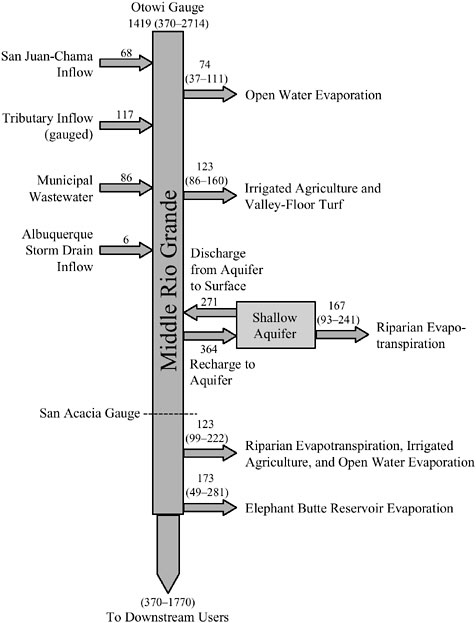
Although evapotranspiration is an inevitable consequence of the growth of riparian vegetation, it may be insignificant in comparison to other water uses. For example, reservoirs for surface water storage can lead to water losses by evaporation that may exceed those caused by evapotranspiration. For example, in the Middle Rio Grande in New Mexico, evaporation from Elephant Butte Dam is a larger component of loss before delivery to downstream users than is evapotranspiration from riparian vegetation (Figure 3-4). Increasing regulatory constraints on stream and floodplain alteration, and more limited access to public and especially federal funds, have also resulted in a decrease in or elimination of large-scale phreatophyte-eradication programs. For these reasons, current efforts are comprised of comprehensive studies assessing the role that riparian vegetation plays in ecosystem processes and even attempts to restore and enhance phreatophytes, especially in urban areas where riparian vegetation has been degraded or eliminated (J. Stromberg, Arizona State University, personal communication, 2001).
Phreatophyte control continues today for reasons such as reducing mosquito habitat. Saltcedar is the species most often targeted for control, partly because it
is an exotic species and because it happens to dominate in areas where attention is focused on phreatophyte issues. Saltcedar represents a particularly troublesome case because of the perceived advantages and disadvantages of removing it from riparian areas. On the one hand, saltcedar is an exotic whose removal not only could increase floodwater conveyance (although this has yet to be demonstrated), but could also provide more habitat for native plant species. At the same time, saltcedar has been proposed for protection because of its role as nesting habitat for the southwestern willow flycatcher, a federally listed endangered species (Leon, 2000). The Bureau of Reclamation has been controlling saltcedar on about 40,000 acres in New Mexico since the 1960s, but it has been unable to demonstrate positive changes in streamflow as a result, probably because of other factors such as groundwater pumping. Insects for biological control of saltcedar are now being released on a trial basis (DeLoach, 2000; J. Stromberg, Arizona State University, personal communication, 2002).
AGRICULTURE
Traditional Agricultural
Nationwide, agriculture is probably the largest contributor to the decline of riparian area quality and functioning (Dillaha et al., 1989). Because some of the most fertile soils are often located in riparian areas, there is an economic incentive for their conversion to cropland. These areas are also convenient sources of water for irrigation of adjacent cropland and, as previously discussed, excessive water withdrawal from streams lowers water tables and causes significant change to riparian area structure and functioning. In nonforested areas, there can be a tendency to encroach into the riparian area each time the field is plowed in an attempt to gain more cropland. Natural riparian areas are sometimes viewed as a potential source of plant and animal pests, a source of shade that may reduce crop yields, and competition for scarce water resources. In areas where agriculture is concentrated, such as the Midwest, these activities have converted millions of acres of native grasslands, prairie, and wetlands, including riparian areas, into croplands.
Direct effects of agricultural management practices on riparian areas are listed in Figure 3-5 and illustrated in Figure 3-6. Under natural settings, riparian vegetation protects the soil surface, and soil fauna and flora are constantly creating macropores, which maintains high infiltration and percolation rates. When land is converted to agriculture—particularly row crops—vegetative cover is reduced, which exposes soil to raindrop impact and surface sealing, thereby decreasing infiltration. Although agricultural tillage does help to maintain porosity in soil, which promotes infiltration and percolation, it does not do so to the extent achieved by undisturbed populations of soil flora and fauna. The machinery used in tilling can also compact soils. Together, these practices alter the
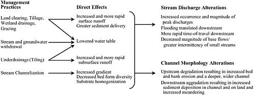
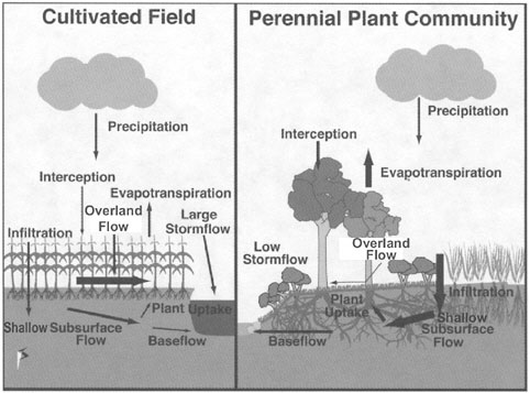
FIGURE 3-6 Differences in water movement in a non-tiled annual row-crop field and a perennial riparian forested buffer. More overland flow and less total evapotranspiration result in larger storm flow in the row-crop field while in the perennial riparian plant community, higher rates of infiltration and annual evapotranspiration reduce storm flow and increase baseflow. SOURCE: Reprinted, with permission, from Schultz et al. (2000). © 2000 by American Society of Agronomy.
hydrology by increasing overland flow volumes, peak runoff rates, and potential pollutant delivery to riparian areas. Stream channels respond to these increased runoff frequency, volumes, and peak flow rates by increasing their cross-sectional area to accommodate the higher flows—either through widening of the stream channel, downcutting of the streambed, or both—similar to what is observed during channelization (see Figure 3-3).
The altered hydrology characteristic of row-crop agriculture and some erosion control structures tends to concentrate overland flow within fields and transport it downslope in grass waterways or other ephemeral drainageways (Schultz et al., 2000). Although grass waterways are very effective in reducing gully erosion, transformation processes that could improve water quality are limited because the upland runoff enters the riparian area as concentrated flow. Also, the increased overland flow over agricultural land promotes relatively high erosion
rates, such that adjacent riparian areas trap substantial amounts of sediment (Dillaha et al., 1989). Over time, the upslope portion of the riparian area evolves into a terrace or berm that, if not managed via tillage, can hinder further inflow. When this occurs, runoff flows parallel to the riparian area until a low point or drainageway is reached. The diverted overland flow enters the riparian area as concentrated flow, which again reduces its effectiveness for water-quality protection.
Agricultural chemicals (both pesticides and fertilizers) in overland flow can also negatively impact fauna and flora located in riparian areas and downstream receiving waters. Edge-of-field pesticide losses are common, with 1–10 percent of the amount of pesticide applied being entrained in overland flow (Wauchop, 1978; Baker, 1983). Similarly, fertilization can cause nutrient losses from the land to nearby streams to increase by an order of magnitude or more.
Healthy riparian areas often provide significant benefits to traditional agricultural activities. Riparian areas protect the quality of water resources used for agricultural and domestic purposes by trapping sediment, nutrients, and other pollutants. They stabilize stream channels and they promote the infiltration of overland flow. They increase groundwater resources by enhancing groundwater recharge in losing streams. They can reduce wind erosion; trap snow, thus reducing drifting; protect livestock, wildlife, and buildings from excessive wind; and reduce noise and odors associated with some agricultural activities. Riparian areas can also be a potential source of income through their use for hunting and fishing and for timber and biomass production. Unfortunately, these benefits have historically not played a role in agricultural management of riparian lands.
Drainage Tiles and Ditches
The draining of water from urban and suburban lands for the purposes of improved crop production has been practiced since the 1870s, spurred by the 1849 and 1850 Swamp Act and the subsequent organization of local drainage districts. Farmers have relied on drainage to improve soil aeration, alter soil moisture conditions to allow earlier planting and easier fall tillage, and combat disease organisms that thrive in high-moisture conditions. Without drainage, many Midwest farmlands would be significantly reduced in productivity or simply unfarmable (Fausey et al., 1995).
Drainage occurs through subsurface tiles (e.g., perforated polyethylene pipe or other older methods such as clay tiles) or by networks of ditches. In practice, surface and subsurface systems often are used together. For example, drainage tiles often intercept channelized streams or ditches created for the purpose of collecting tile outflow. Table 3-2 shows the acreage of drained land in the most heavily affected regions of the United States. Drainage impacts approximately 20.8 million hectares or 37 percent of the 55.7 million hectares of cropped farmland in the Midwest (Pavelis, 1987; Zucker and Brown, 1998). In Illinois, the
TABLE 3-2 Agricultural Drainage for the Most Heavily Drained States
|
State |
Harvested Cropland (1,000 ha)a |
Drained Cropland (1,000 ha)b |
Percent of Cropland Drained |
State Total Area (1,000 ha)c |
|
Great Lakes and Cornbelt States |
||||
|
Illinois |
9,014 |
3,569 |
40 |
35,580 |
|
Indiana |
4,742 |
2,782 |
59 |
22,957 |
|
Iowa |
9,439 |
2,834 |
30 |
35,760 |
|
Ohio |
4,007 |
2,397 |
60 |
26,209 |
|
Minnesota |
7,677 |
1,934 |
25 |
50,954 |
|
Michigan |
2,721 |
1,563 |
57 |
36,358 |
|
Missouri |
5,038 |
1,202 |
24 |
44,095 |
|
Wisconsin |
3,491 |
409 |
12 |
34,761 |
|
Mississippi Delta |
||||
|
Arkansas |
3,102 |
2,151 |
69 |
33,328 |
|
Louisiana |
1,571 |
1,562 |
99 |
27,882 |
|
Mississippi |
1,756 |
1,440 |
82 |
30,025 |
|
Southeast |
||||
|
Florida |
986 |
1,146 |
100 |
34,558 |
|
North Carolina |
1,713 |
984 |
57 |
31,180 |
|
South Carolina |
670 |
426 |
64 |
19,271 |
|
Georgia |
1,523 |
219 |
14 |
37,068 |
|
Other States |
||||
|
North Dakota |
8,271 |
910 |
110 |
44,156 |
|
Texas |
7,935 |
1,283 |
16 |
167,625 |
|
Tennessee |
1,645 |
256 |
16 |
26,380 |
|
New York |
1,504 |
333 |
22 |
30,223 |
|
Maryland |
559 |
367 |
66 |
6,256 |
|
Delaware |
189 |
130 |
69 |
1,251 |
|
U.S. Total |
125,212 |
|
|
2,263,587 |
|
aFrom 1997 National Agricultural Statistics for harvested cropland, which includes land from which crops were harvested or hay was cut and land in orchards, citrus groves, Christmas trees, vineyards, nurseries, and greenhouses. NAS also reports total cropland, which includes cropland used for pasture or grazing, land in cover crops, legumes, and soil-improvement grasses, land on which all crops failed, land in cultivated summer fallow, and idle cropland. bFrom Pavelis (1987) converted to metric units and rounded to nearest 1,000 ha. cFrom USDA (1997). |
||||
state with the greatest amount of drained farmland acres, it is estimated that over 4 million hectares are drained by a vast network of underground drainage tiles. In some highly drained areas, such as the Embarras River watershed of east central Illinois, tiles drain 70 percent to 85 percent of the cropland (David et al., 1997). Other areas such as the Southeast (6 million hectares) and the Mississippi Delta (5 million hectares) also have significant areas of drained cropland.
Because drainage was traditionally a tool for managing soil moisture, the resulting water quality of receiving streams and other ecological factors were
rarely if ever considered. It is now known that drainage has had a dramatic impact on stream hydrology and water quality and on the functioning of riparian areas (Evans et al., 1995; David et al., 1997; Kovacic et al., 2000). By concentrating flows and circumventing the biological processes that typically occur in riparian areas, drainage tile effluent can have greater peak flows, increased concentrations of nutrients, and either increased (surface drainage) or decreased (some types of subsurface drainage) sediment load. Many of the effects of surface drainage are similar to those discussed above for channelization and traditional agriculture.
The hydrologic differences among drained cropland, non-drained cropland, and undisturbed land have been investigated by Zucker and Brown (1998). Compared to non-drained cropland, tile-drained cropland has less erosion and phosphorus runoff because of limited overland flow. However, in relation to non-cropped areas or cropped areas with various conservation practices, the environmental advantages of tile drainage are less clear or nonexistent. For example, studies in North Carolina have shown that compared to undisturbed sites, total outflow is increased by 5 percent with surface drainage and 20 percent for subsurface drainage (Evans et al., 1995). Evans et al. (1995) found that both total flow and peak outflow were increased in drained areas compared to undeveloped areas. Depending upon conditions—such as antecedent soil moisture and storm intensity—surface and subsurface drainage were found to increase peak outflow rates by four and two times, respectively (Figure 3-7). This increased outflow often results in streambank erosion, channel incision, flooding, or other impacts.
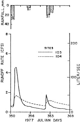
FIGURE 3-7 Increase in peak outflow rates typically associated with drainage and land conversions to agriculture. Site 104 is a natural, undrained site and Site 103 is a surface drained and developed pocosin converted to agricultural use. SOURCE: Reprinted, with permission, from Evans et al (1995). © 1995 by American Society of Civil Engineers.
Indeed, the changes in hydrology characteristic of extensively tiled areas can be so extreme that in many first- to third-order streams, flow from drainage tiles may constitute 90 percent of the baseflow during summer months (Schultz et al., 2000).
Drainage also affects the transport of particles and chemical pollutants through riparian areas. As shown schematically in Figure 3-8, subsurface drainage can expedite direct transport of chemicals (such as NO3-N) from the soil zone to surface waters—often completely circumventing riparian areas. Thus, approximately 37 percent of the cropped land in the Midwest is not afforded the beneficial nutrient absorbing and transforming processes of riparian areas. As a result, where nutrients are added to cropland, they often are delivered to the stream systems at highly elevated levels (David et al., 1997; Kovacic, 2000). Surface drainage systems typically produce higher concentrations of phosphorus and sedi-
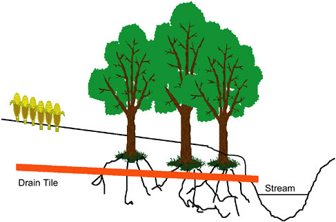
FIGURE 3-8 Short-circuiting of the riparian area by a drainage tile. Drainage tiles typically bypass the functioning of riparian areas by conveying water directly from upland areas to the stream systems. Tiles prevent riparian-related activities such as denitrification, and they enhance water conveyance, resulting in higher peak flows and greater total runoff. SOURCE: Reprinted, with permission, from Kovacic (2000).
ment than do subsurface systems, while subsurface systems typically contain higher concentrations of NO3-N than do surface systems (Evans et al., 1991; Thomas et al., 1995). The short-circuiting of riparian areas via drainage is especially troubling in areas like the Midwest where soils are underlain by an impermeable aquiclude (Schultz et al., 2000). In such places, the riparian area may constitute the only biologically active zone through which pollutants from cropland could be transformed. The high nutrient loadings resulting from drainage networks have been implicated in the hypoxia in the Gulf of Mexico (Turner and Rabalais, 1991) as described in Box 3-2.
Grazing
Domestic Livestock
The history of grazing by domestic livestock in much of the world has been one of large-scale degradation of native plant communities (Chaney et al., 1990; Kauffman and Pyke, 2001). Although domesticated livestock have played a
|
BOX 3-2 The hypoxic zone in the Gulf of Mexico has increased in size since the 1950s, nearly doubling in average size from 1985–1992 to 1993–1999. The area, defined by dissolved oxygen levels of less than 2 mg/L, averaged 5,500 mi2 (14,000 km2) in size over the 1996–2000 period, and is found off the Louisiana coast near the outflow areas of the Mississippi and Atchafalaya Rivers. These and other waters in the northern Gulf of Mexico constitute approximately 40 percent of U.S. fisheries, generating $2.8 billion annually, which makes the potential effect of hypoxia a critical issue (CENR, 2000). The hypoxic zone has been caused by a complex mix of increased nutrient loads transported by the rivers and physical changes to the basins through activities such as channelization and loss of wetlands and riparian vegetation. These factors produce a higher oxygen demand that, when coupled with water column stratification in the Gulf resulting from the freshwater–saltwater interface, can lead to hypoxic lower layers of water. It has been estimated that 90 percent of the nitrates entering the Gulf come from urban and agriculture runoff (56 percent from the Mississippi River Basin and 34 percent from the Ohio River Basin). Two primary approaches have been developed to address hypoxia (CENR, 2000; Mitsch et al., 2001). The first approach involves efforts to reduce nitrogen loads in streams and rivers in the basin through activities such as reducing fertilizer applications to recommended rates, increased use of conservation tillage systems, and improved sewage treatment. The second involves enhancing denitrification and nitrogen retention within the Mississippi–Atchafalaya River Basins through restoration of ecological systems such as riparian areas and wetlands. The stated goal of the Mississippi River/Gulf of Mexico Watershed Nutrient Task Force is to reduce by the year 2015 the average hypoxic area to 2,000 mi2 (5,200 km2). One of the many programmatic indicators (22 were defined) that will be used to track progress is the establishment of vegetative and forested buffers along rivers and streams in watersheds known to contribute significant quantities of nitrogen. Using an annual denitrification rate of 40 kg N/ha for riparian areas, 7.8 million acres of new riparian areas would be needed to attain a 20 percent reduction in nitrogen loads. Other estimates were also developed for wetlands acreage needed, fertilizer application options, tillage, and other possible remedies. In the final assessment, however, it was recognized that no single approach would be completely successful and that a wide variety of approaches relying upon the many existing federal, state, local, and private programs will be needed to accomplish the changes necessary to solve the Gulf hypoxia problem (EPA, 2001). |
prominent and largely beneficial role in human society for thousands of years, providing food, fuel, fertilizer, transport, and clothing, they have had a dramatic negative impact on global biodiversity. As shown in Figure 3-9, primary grazing effects include the removal of vegetation, trampling of vegetation, destruction of biological soil crusts, compaction of underlying soils, redistribution of nutrients, and dispersal of exotic plant species and pathogens. Secondary effects include
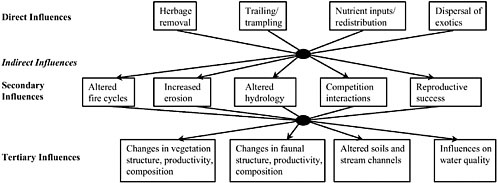
altered disturbance regimes associated with hydrology (runoff and infiltration rates and water-holding capacity) and fire (frequency and severity), accelerated erosion, altered competitive relationships among organisms, and changes in plant or animal reproductive success and/or establishment of plants. Long-term cumulative effects of domestic livestock grazing involve changes in the structure, composition, and productivity of plant and animal communities at community, ecosystem, and landscape scales. These tertiary effects often include overall declines in biotic richness or diversity of affected aquatic, riparian, and terrestrial areas.
In 1980, the U.S. Department of Agriculture estimated that vegetation on more than half of all western rangelands had deteriorated to less than 40 percent of productive potential. Although this reflects changes principally in upland conditions, there is no doubt that the impacts to western riparian areas are likely to have been much more severe, for reasons described below. Although upland range conditions reportedly have improved in many areas since 1980, extensive field observations in the late 1980s suggest that riparian areas remain in degraded condition (Chaney et al., 1990; BLM and USFS, 1994).
The disproportionate impact of livestock on riparian areas is a product of both management and animal behavior. First, until the 1960s (if not later), riparian areas were considered “sacrifice areas,” used chiefly for supplying forage and water to livestock (Stoddart and Smith, 1955). Although riparian areas comprise 1 percent or less of the arid land area of the 11 western states (Belsky et al.,
1999), they nevertheless provide a substantial amount of the available forage. Roath and Krueger (1982) found that a riparian area in eastern Oregon occupied less than 2 percent of a grazing allotment’s area, but it produced 21 percent of the available forage and supplied 81 percent of forage actually consumed by cattle. Second, cattle in particular congregate in riparian areas and other wet areas because of the availability of water, shade, and more succulent forage—spending from 5 to 30 times more time in these cool, productive zones than would be predicted from surface area alone (Belsky et al., 1999).
The grazing of riparian areas by domestic livestock involves the periodic removal of native streamside vegetation—particularly herbaceous plants, shrubs, or young trees. Along many streams and rivers, it has been a common practice to remove certain plants over time to create livestock pastures or hay fields or to convert the land to crop production. Grazing itself occurs over varying time periods (e.g., days, weeks, months, or seasons) and is typically repeated on an annual basis. Characteristics of the riparian plant communities, such as composition, cover, density, or other measures of plant communities, are likely to show significant changes relative to ungrazed areas (Kauffman and Pyke, 2001). In addition, a variety of effects on soils (e.g., reduced litter cover, increased bulk density, greater percentage of bare ground, decreased infiltration) and impacts on local wildlife and aquatic systems are common (Dwyer et al., 1984; Kauffman and Krueger, 1984; Howard, 1996; Ohmart, 1996). Where riparian vegetation has been suppressed or removed via grazing over long periods of time, the root biomass along channel banks and the resistance to overbank flow may become sufficiently reduced such that channels become unstable. Channel widening and gullying (as shown in Figure 3-3 for channelization) are common features of areas that have experienced the effects of season- or year-long grazing or other intensive grazing practices. Intensive grazing of the arid southwest in the late nineteenth century is thought to have played a role in the extensive arroyo cutting observed in this area, although cycles of arroyo cutting and filling prior to the introduction of domestic livestock have also been documented (Bull, 1997; McFadden and McAuliffe, 1997; Gonzalez, 2001).
Season-long grazing (commonly used throughout the West) results in major impacts to riparian areas because a large proportion of plant biomass is removed, the remaining vegetation has little opportunity to recover, and the grazing is generally repeated year after year. Grazing systems that employ rest-rotations or that result in less intensive utilization of riparian forage can potentially reduce these impacts, but these approaches have not been widely used and their potential ecological effects have received little study (Elmore and Kauffman, 1994). Of 17 grazing strategies evaluated by Platts (1991), only a few were consistently rated “well,”3 including
riparian pasture, corridor fencing to exclude cattle, rest-rotation with seasonal preference (sheep only), and total exclusion of sheep and cattle.
Given the many impacts of grazing described above, it is no surprise that aquatic organisms and riparian wildlife have been profoundly impacted by historical grazing practices. Two reviews have illustrated the adverse effect grazing has had on fisheries and wildlife. Over 95 percent of the studies reviewed by Platts (1991) showed “stream and riparian habitats had been degraded by livestock grazing, and that these habitats improved when grazing was prohibited.” In Ohmart’s (1996) view, “Unless grazing management changes are made soon it is predictable that many more species, especially neotropical birds will be placed on the endangered species list.” Of the 76 federally listed plant and animal species on Bureau of Land Management (BLM) lands, for which livestock grazing was a significant factor in their decline, approximately 80 percent were dependent on or associated with riparian habitats (Horning, 1994).
Federal land management agencies have often concurred with these assessments. In 1994, BLM and the U.S. Forest Service (USFS) concluded that “watershed and water quality would improve to their maximum potential” if livestock were removed entirely from federal lands (BLM and USFS, 1994). The USFS concluded that livestock grazing is the fourth major cause of species endangerment nationwide, the second major cause of plant endangerment, and the number one cause of species endangerment in certain arid regions of the West, such as the Colorado Plateau and Arizona Basin (Flather et al., 1994). Several writers have suggested that “livestock grazing may be the major factor negatively affecting wildlife in the 11 western states” (Ohmart and Anderson, 1986; Fleischner, 1994; Ohmart, 1996). Although there is limited evidence from more humid regions, Belsky et al. (1999) suggest that environmental impacts of grazing in these regions are similar to those in drier areas.
Native Ungulates
Like livestock, native ungulates can modify riparian areas by eating plants, dispersing seeds, disturbing soil, and modifying channel morphology. Impacts on plants can include suppressed vigor, reduced reproductive output and regeneration, and increased mortality (Opperman and Merenlender, 2000). For example, successful regeneration of white cedar in winter deeryards can be virtually nonexistent because of concentrated seasonal browsing (Verme and Johnston, 1986). The effects of native ungulates depend on their populations, which fluctuate in response to predation, competition, weather, disease, and other influences (Naiman and Rogers, 1997). White-tailed, mule, and black-tailed deer, elk, and moose have drawn attention when their numbers are particularly high or when their presence is concentrated temporally. Such situations are most likely to occur as a result of human-induced changes in the landscape, or a change in predator–
prey dynamics [as exemplified by exploding deer populations (McShea et al., 1997; Hubbard et al., 2000)].
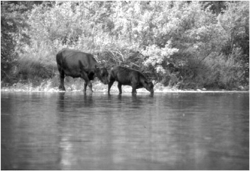
In some of the nation’s parklands, native ungulates have increasingly become a riparian management issue. Elk and moose browsing have caused damage (e.g., reduced or eliminated woody species cover, limited regeneration) to cottonwoods, willows, and aspens in riparian areas and other portions of Yellowstone and Grand Teton National Parks and the National Elk Refuge in Jackson Hole, Wyoming (Kay, 1997a,b; Matson, 2000). Moose browsing on riparian willow thickets is believed to suppress both density and diversity of migrant breeding birds dependent on riparian vegetation (Berger et al., 2001). The extent and causes of this damage are controversial, though a lack of ungulate population regulation by either hunting or predation is considered at least partially to blame.
In the Greater Yellowstone area, the extinction of grizzly bear and wolf populations has been linked to increases in moose density (Berger et al., 2001). In areas supporting both livestock and wild ungulates, livestock have been observed to do greater damage to forage resources. For example, native ungulates are scattered over their summer range, making their impact on forage resources minimal to moderate, while many domestic livestock graze on aspen-covered ranges in the West during the peak of the growing season and commonly use at least 50 percent of the annual production of palatable forage (DeByle, 1985). Another study found that wild ungulate use of riparian sites in Idaho, Utah, and Nevada was “trivial” compared to livestock use of the same areas (Platts and Nelson, 1985). Long-term studies in Utah and Nevada showed that aspen fails to regenerate or regenerates only at low stem densities when it is grazed by both livestock and native ungulates (Kay and Bartos, 2000; Kay, 2001). In the absence of livestock, however, aspen regenerated successfully, provided that deer numbers were low.
In many human-modified landscapes, losses in the amount of available native habitat have concentrated herbivore pressure in an area that is already under stress. Hobbs and Norton (1996) used exclusionary fencing to show that deer were a limiting factor to the restoration of a riparian area that had been previously degraded by domestic livestock. It was suggested that the site had reached a threshold of degradation beyond which recovery was not possible without exclusionary fencing to reduce ungulate browsing. Given the high populations of deer in many areas, particularly urbanized landscapes, exclusionary fencing or targeted population control may be needed to reduce herbivore pressure and assist in riparian area recovery.
Forestry
The removal of trees by forestry operations has the potential to alter longterm composition and character of riparian forests, and thus the structure and function of these systems (Ralph et al., 1994). If selection harvest methods are
employed and small amounts of timber removed, and if the frequency of harvest is separated by several decades, the effects on riparian plant communities may be relatively small. However, where large portions of the standing timber are harvested or where the period between harvest operations is short, substantial changes to the composition, structure, and function of riparian forests almost certainly will result. Figure 3-10 shows the decline in virgin forest in the United States from 1620 to 1920.
The location and construction of logging roads (e.g., temporary or permanent, loggers choice or a planned transportation system) along streams can affect
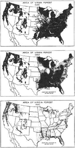
FIGURE 3-10 Virgin forest area in 1620, 1850, and 1920. This figure shows an estimate of forests have never been cut. It does not show the current total area of forest. SOURCE: Reprinted, with permission, from Verry et al. (2000). © 2000 by CRC Press, LLC via Copyright Clearance Center.
the long-term character of riparian forests (Adams and Ringer, 1994). Upslope roads can increase hillslope erosion rates (either surface erosion or landslides) or materially alter flow pathways, for example via the interception of shallow subsurface flow into ditches and its rerouting to locations of instability (Furniss et al., 1991).
Forest harvesting can occur in a variety of ways depending upon forest type, age, and density and upon topography, climate, and utilization standards. The impacts of forest harvest systems on riparian structure and function are much greater when forests are clearcut or harvested right up to streambanks and lake shorelines. The total harvest of riparian vegetation and adjacent terrestrial forests can increase the amount of solar radiation reaching the water surface, which can increase water temperatures and affect aquatic primary production. Temperature increases are of particular concern during summer when streams and rivers are naturally warmer. In addition, removal or alteration of the riparian vegetation changes the quantity and quality of terrestrial food resources for a stream, such as leaves, needles, and other forms of organic matter. Removal of riparian forests and repeated harvest over short rotations (e.g., 40–80 years) greatly reduce the potential for large-wood recruitment into a stream. Harvest of streamside forests also removes the vegetative cover that can slow the delivery of sediment into streams and retain nutrients, such as nitrogen and phosphorus.
As discussed in Chapter 2, riparian forests collectively provide for an array of sustainable processes and functions that make them exceptionally important for maintaining productive aquatic and terrestrial ecosystems (Johnson et al., 1985; USFS, 1993; Laursen, 1996; Verry et al., 2000). Those functions, as measured by species richness and diversity, can be impaired by forestry operations. Studies have demonstrated the habitat value of uncut riparian areas for wood-peckers (Conner et al., 1975) as well as for secondary cavity nesters such as chickadees, swallows, bluebirds, and nuthatches (Balda, 1991). The red-shouldered hawk is associated with wooded bottomlands of major rivers (Brewer et al., 1991; Robbins, 1991); work in Ontario suggests that cutting specifically in riparian woodlots may be responsible for declines in this species (Bryant, 1986).
The hydrologic effects of timber harvesting, such as increased annual water yields, increased sediment production, and altered stream chemistry, have been documented from a large number of watershed studies in forested areas (Ponce, 1983; Binkley and Brown, 1993; Adams and Ringer, 1994; Murphy, 1995). Such responses have not occurred universally and are typically dependent upon terrain conditions, the amount of timber removed, the type of logging system, post-harvest rainfall patterns, soil type, and other factors. Although increased water yields are most common when large proportions of the forest are harvested, increases in peak flows have not occurred consistently (Reiter and Beschta, 1995; Beschta et al., 1999). Increased sediment production is most likely in steep terrain where ground-based logging systems are employed or where soils are disturbed
severely by post-harvest site preparation (e.g., mechanical scarification, hot slash burns) (Beschta, 1990).
Chapter 5 discusses how to diminish the potentially adverse effects of timber harvest upon aquatic and riparian resources by the use of various types of buffers or riparian reserves. Even in cases where forestry has been moderated for restoration purposes (e.g., by using partial harvest), riparian function may be impaired more than simple buffer width would indicate. Partial harvest often allows selective removal of larger or older trees, reducing ecological function more than width and targeted stem densities might reflect. Streamside buffers are generally not designed to mirror the stand composition and dynamics of desired healthy riparian forests for a given age class, especially when harvest decisions are strongly governed by social concerns about economic impacts.
Nearly 136 million acres of the nation’s forestland are in the public domain, with 85 million acres being managed by the USFS, 8 million by BLM, and 43 million by state, county, and municipal governments. Private holdings amount to 347 million acres, of which 71 million are controlled by the forestry industry (Coggins et al., 2001). One of the major challenges in riparian management on public lands is the lack of a consistent scientific framework for determining widths of forested riparian areas that will sustain their desired structural and functional attributes. Differences in management between forest regions and individual national forests, between forests managed by the USFS and BLM, and among federal, state, and privately owned forests are more often based on policies, economic considerations, political pressure, and litigation than on differences in forest types, hydrologic regimes, climate, geology, physiographic provinces, or the ecological functions of riparian plant communities. Significant protection and restoration of forested riparian areas across the United States are unlikely until a common framework is developed.
INDUSTRIAL, URBAN, AND RECREATIONAL IMPACTS
Mining
Mining has historically been, and continues to be, an important land use in many portions of the United States, particularly on public lands. The General Mining Law of 1872 authorizes hardrock mineral extraction (e.g., gold, silver, nickel, copper) on all public lands that have not been specifically withdrawn from mineral development. Approximately 147 hectares (364 million acres) of public lands (constituting 80 percent and 90 percent of all lands managed by the USFS and BLM, respectively) are open to mining (NRC, 2000a).
Because only a small percentage of the U.S. land surface has been mined—less than 1 percent in recent decades according to Starnes (1983)—the effects of mineral extraction might initially be assumed slight. However, local degradation can have major downstream effects, thus affecting aquatic and riparian resources
for long periods of time (Richardson and Pratt, 1980; Nelson et al., 1991; Wilkinson, 1992).
The mining of hillslopes and valley bottoms for minerals ranging from gold and silver to coal and gravel has involved a wide variety of approaches depending upon geology, topography, available technology, market value, and other factors. In hard-rock mining, the excavation of rock and soil to retrieve a mineral or ore of value to society often results in large amounts of waste rock or spoils. The extent to which such materials influence riparian areas depends on the amount of spoils deposited along stream channels; in other situations the acidity of the spoils can be a major concern. Acid mine drainage is considered to be one of the major water pollution concerns associated with many mining operations (Nelson et al., 1991). In addition, mining may introduce toxic metals such as arsenic, cadmium, chromium, copper, lead, mercury, and zinc, particularly when surface or groundwater is allowed to flow through waste piles.
Open-pit mining, where soils and rock overburden are excavated and embanked at a nearby location, is often employed when relatively low-grade ores or less valuable minerals are sought. The potential for riparian areas in or near these types of mining operations to be affected is often great. Depending upon the size and location of the mining operation, total hillsides can be excavated and their stream systems moved or buried. For example, so-called “mountaintop removal” for the mining of coal, which occurs principally in West Virginia and parts of Pennsylvania, involves placing excess spoil material into valley bottoms. This practice, which can bury and literally destroy streams, was ruled illegal in a 1999 federal district court decision. But since then, federal rule changes have been proposed that would again permit the practice under certain conditions.
When a mining operation exposes large areas of bare ground, substantial increases in overland flow and sediment production can occur during rainfall periods. Unless a well-designed and operated system of detention ponds is in place, such runoff may greatly increase sediment loading to nearby streams and rivers. Revegetation of embanked overburden and spoils is often a challenge for many open-pit mining operations.
Historically, placer mining was a common means of accessing certain types of minerals, particularly gold. Some placer operations utilized high-pressure water directed at hillslope soils or deposited alluvium—an incredibly effective method for eroding and washing large volumes of sediment into streams and riparian areas. Unable to transport the massive volumes of alluvium and hillslope sediment produced over a short time period, channels became quickly clogged. Channel aggradation, floodplain aggradation, and highly unstable channels downstream of placer mining operations were common. As might be expected, such operations have major detrimental effects on both aquatic and riparian areas and often present formidable restoration challenges (Rundquist et al., 1986; Inter-Fluve, Inc., 1991).
In some portions of the United States (e.g., the West and Alaska), dredging of valley bottom sediments with floating dredges was a common means of mining mineral deposits, typically gold. The use of floating dredges was limited to valleys with significant floodplains so that the dredge could excavate its own flotation pond as it progressed across as well as up and down a particular valley bottom. To retrieve the gold present in valley sediments, all vegetation was removed, and the soils and underlying gravel substrates (often to depths of several meters) were mechanically dredged to the surface. Once the gold was separated on the dredge, the remaining mixture of soil and rock was dumped in arcshaped spoil piles behind the dredge. Although most dredge mining occurred many decades ago, the resulting coarse-rock spoil piles often remain, typically unvegetated. Little effort has been made to reclaim the streams and riparian areas where dredge mining occurred.
Another form of mining practiced along many rivers and streams for extended periods of time is gravel mining (Williamson et al., 1995). Extraction of gravel, primarily for use in construction products, typically occurs along rivers and adjacent floodplains where extensive gravel deposits, often sorted by size class, are naturally found. The excavation of gravel from terraces (i.e., inactive floodplains) may have little impact on riparian systems. However, gravel excavation on active floodplains can directly reduce riparian vegetation and alter groundwater patterns. Impacts to riparian areas also can occur when gravel is mined from channels. In these situations, bar-scalping and streambed excavation can greatly influence long-term sediment transport, channel morphology, and bank stability of specific stream reaches. If large amounts of gravel are removed, channel down-cutting or incision may occur, potentially influencing local groundwater levels, the frequency of overbank flows, bank stability, and the character of riparian vegetation (Collins and Dunne, 1989; Kondolf, 1995).
Mining of heavy mineral sands for titanium-bearing minerals, zircon, and monazite is another potential threat to riparian areas. Although most heavy mineral sand is mined outside of the United States because of wetland protection laws, economic deposits of such sands are found along the Atlantic Coast and are currently mined in Florida and Virginia (Brooks, 2000). These deposits are often located in and adjacent to riparian areas. Heavy mineral sands are usually extracted using surface mining with floating dredges and concentrators after removing harvestable timber and other vegetation from the site. Topsoils are then removed and stockpiled for reclamation purposes, unless they contain high concentrations of heavy sands. The mineral concentrate produced at the mine is typically 90 percent heavy mineral, which is transported to a plant for separation into constituent minerals (Brooks, 2000). Unlike many of the other mining activities described, heavy mineral sand mining sites are amenable to restoration. Reclaimed mine sites have been successfully reestablished as wetlands, forest, pastures, and row crops.
Transportation
River Transportation and Removal of Large Wood
The rivers of the United States provided the first systematic transportation system for a developing nation. Lewis and Clark, in their exploration of the Louisiana Territory and lands west to the Pacific Coast in the early 1800s, relied primarily on rivers to transport their party across the uncharted lands. Keelboats, barges, river steamboats, canoes, and other watercraft plied the nation’s rivers, moving people, farm products, and other materials over long distances.
To improve a river for transportation purposes often necessitated the removal of large wood and other obstructions. By the early 1900s, most rivers in the United States had experienced the systematic removal of large wood, or snags (Sedell et al., 1982; Maser and Sedell, 1994). Thousands of kilometers of river length were “snagged” and more than 100 snags per kilometers were often removed. Although there has been little systematic study of the effects of these snagging activities upon channel characteristics, riparian functions, and floodplain processes, the effects are likely to have been significant.
In the early years of this country, transportation of logs and timber to market was a major challenge. The downstream movement of aggregations of logs—log driving—was a relatively inexpensive means of transporting large volumes of wood over long distances. However, before a log drive could be conducted, boulders, leaning trees, sunken logs, and other forms of obstructions were blasted or otherwise removed in order to more easily float logs downstream. The number of streams affected by log drives was large. For example, by 1900 over 130 incorporated river- and stream-improvement companies were operating in Washington State. To assist the downstream movement of wood, splash dams were commonly employed to provide a surge of water (Sedell and Luchessa, 1981). Log drives that occurred on the Yukon, Chena, and Tanana Rivers in Alaska have been well documented (Sedell et al., 1991). Splash dams and log drives have also been used on rivers in the Rocky Mountains and in the eastern portion of the country. Although log drives and associated wood removal are now only a part of history, there is no doubt that the effects to channels and their riparian areas have been substantial and long-lasting.
Today, the nation’s major rivers continue to be extensively utilized as major transportation routes. Ocean-going ships use the St. Lawrence Seaway and the Great Lakes for transporting a wide variety of goods and materials. Similarly, the use of barges on the Mississippi, Missouri, Ohio, and Columbia Rivers and on other waterways of the nation is an important means of transporting large amounts of cargo. Although the economic importance of these waterways is obviously great, so are the ecological effects of channelization, construction of locks, and other facets of maintaining transportation corridors along these river systems (NRC, 2001, 2002).
Roads and Railroads
Vehicular access to homes and communities, factories and production facilities, farms and ranches, recreational areas, rangelands, forests, and other locations is a characteristic feature of American society. Many of the country’s road systems have had far-reaching and often permanent impacts to riparian areas, which were seldom considered during the planning of most highway and railroad systems. For example, the placement of highways along rivers and lakeshores has been a particularly common practice, the ecological effects of which have been observed to extend as much as 600 m on each side of the road (Formann and Deblinger, 2000). Significant impacts to riparian areas are likely to have occurred, particularly where narrow valleys and steep hillsides (and associated high construction costs) generally precluded the location of a road some distance from a river or shoreline. Nationally, similar impacts have occurred with railroads, though at a much-reduced scale.
The direct effects of highways and railroads within riparian areas include (1) the removal of riparian vegetation from the area occupied by the roadbed and the right-of-way, (2) the alteration of topography (extensive fills are often used to provide a roadbed foundation), and (3) local hydrologic modifications involving changes in infiltration and the rerouting of both surface and groundwater. Where sinuous streams were encountered during highway or railroad construction, portions of the channel were often filled to maintain a straight road alignment at the cost of reduced channel length. In some instances, the effects on river length have been substantial. Concurrently, riparian vegetation was often eliminated and replaced with a roadbed.
Another important feature of highway and railroad systems is that they periodically cross watercourses. A wide range of structures can be used for such purposes, but most fall into two general categories—bridges or culverts. Abutments along the bank are typically needed to provide sufficient support at each end of a bridge; in the case of a relatively wide river crossing, additional mid-span piers or pilings are usually employed to provide intermediate support(s) to the bridge span. Because the abutments physically constrain the stream, future lateral adjustments by the stream are effectively eliminated. Similar effects occur at culvert locations—i.e., both vertical and lateral channel adjustments are constrained.
The construction of highway systems and urban roads outside of riparian areas can also have important indirect effects upon streams and riparian areas. In urban areas, roads and other impervious surfaces can increase peak overland flows, thus fundamentally altering the hydrologic disturbance regime for those systems. Roads can also concentrate overland flows to specific locations where channel erosion and gullying and accelerated sediment loading may be initiated. In steep mountainous terrain, an increased frequency of landslides associated with roads may alter the delivery of sediment and large wood to forested streams
and riparian areas. Roads and their associated ditches also increase dispersal of exotic plant species from uplands to riparian areas (Parendes and Jones, 2000; Trombulak and Frissell, 2000). Thus, although the local effects of streamside roads are a high concern with regard to riparian processes and functions, the effects of roads immediately outside riparian areas cannot be ignored (Furniss et al., 1991; Adams and Ringer, 1994).
Urbanization
Urbanization and development have profound impacts on watershed hydrology and vegetation, and consequently on the structure and functioning of riparian areas. Among the most important impacts of urbanization are the increased frequency and magnitude of flooding and decreased baseflow that result from land-use changes typical of development (Schueler, 1987). In its natural state, vegetation intercepts a portion of precipitation, with the remainder being stored in or on the soil surface or infiltrating into the soil where it recharges groundwater or is used by plants. Typically, only a small portion of the precipitation ends up as direct overland flow. Thus, peak flows are moderated by high infiltration rates, and many streams are perennial due to groundwater flow during periods of the year when overland flow is uncommon. As urbanization increases and more of the land surface is covered with homes, buildings, roads, sidewalks, parking lots, and other structures, the imperviousness of the watershed increases. With increased imperviousness, infiltration, interflow, groundwater recharge, groundwater contributions to streams, and stream baseflows all decrease, while overland flow volumes and peak runoff rates increase, as shown in Figure 3-11. As urban-
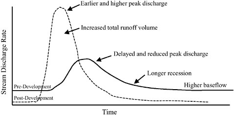
FIGURE 3-11 Effects of urbanization and development on stream flow.
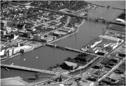
ization and imperviousness increase further, the capacity of natural channels to transport the increased overland flow is exceeded, with the undesirable consequences of accelerated channel erosion and increased flooding. Downstream flooding is further exacerbated by gutters, curbs, culverts, stormwater sewers, and lined channels, which are installed to transport runoff from impervious surfaces to streams as quickly as possible.
The changing land use and hydrology of urbanizing watersheds have multiple impacts on stream channels, aquatic ecosystems, and water quality within riparian areas. As runoff frequency, volumes, and peak flow rates increase during urbanization, stream channels respond by increasing their cross-sectional area to accommodate the higher flows—either through widening of the stream channel, downcutting of the streambed, or both. This phase of channel instability, in turn, triggers a cycle of streambank erosion and habitat degradation (Schueler, 1995). Sediment loadings may increase by one to two orders of magnitude compared to pre-development conditions, such that streambeds are covered with shifting deposits of sand and mud (Schueler, 1987). Fish and aquatic insect diversity and abundance decrease because of changes in temperature, benthic substrates, dissolved oxygen levels, and pollutant loadings. Finally, increased loading of nutrients, bacteria, oxygen-demanding materials, oil, grease, salts, heavy metals, and other toxics is evident.
Depending on the location of urbanization, riparian areas may be converted to urban land uses. Riparian areas of lower-order streams are often totally elimi-
nated, and the width of riparian areas along higher-order streams is generally reduced. In major cities, entire stream systems that have been removed during urban development have been replaced by underground culverts, pipes, and other similar structures to transport overland flow. A secondary effect of urbanization is caused by changes in how overland flow and shallow subsurface flow enter and transverse riparian areas that remain after development. Prior to urbanization, overland flow enters the more extensive riparian areas as either sheet flow from areas immediately adjacent to the riparian areas or through small ephemeral drainageways, thus allowing sediment to be deposited and other substances to be transformed. Much like traditional agriculture, development promotes the formation of concentrated flows that are less likely to be dispersed within the riparian area, greatly reducing the potential for pollutant removal (Dillaha et al., 1989). A similar paradigm holds true for shallow subsurface flow and the removal of dissolved substances. Development is marked by the construction of gutters, storm sewers, and lined channels that often pass directly through the riparian area and discharge directly into the stream channel (much like agricultural drainage tiles). Even when drainage structures are not constructed to bypass riparian areas, flow rates are generally so high that there is little opportunity for transformation processes (such as degradation and assimilation discussed in Chapter 2) to occur. Figure 3-12 illustrates how overland flow increases and infiltration decreases with imperviousness.
The site-specific effects of urbanization on stream habitat and water quality are highly variable. In general, as urbanization, population density, and imperviousness increase, water quality declines. Although somewhat controversial, a threshold in habitat quality is thought to exist at approximately 10 percent to 15 percent watershed imperviousness, beyond which urban stream habitat quality is consistently classified as poor (Shaver et al., 1994; Booth, 1991; Schueler, 1995; Booth and Jackson, 1997).4 However, impacts of urbanization will vary with alternative development models. For example, clustered residential developments, which have the same overall population density as more traditional residential developments, can reduce disturbance of riparian areas and decrease water-quality impacts compared to traditional development. This is accomplished by devel-
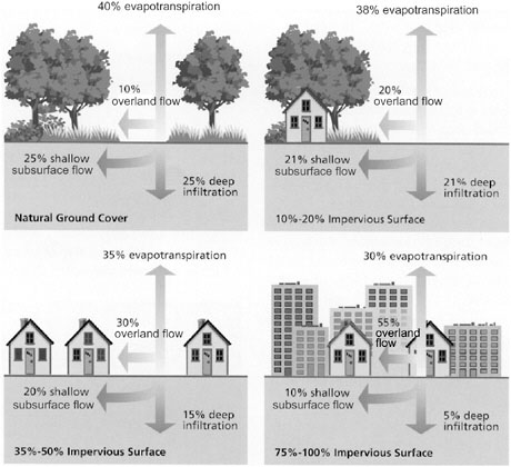
FIGURE 3-12 Relationship between impervious cover, shallow subsurface flow, deep infiltration, and overland flow. SOURCE: Modified from the Federal Interagency Stream Restoration Working Group (1998).
oping smaller lots in areas that are less hydrologically active and are outside of riparian areas. The remaining undeveloped or lightly developed green spaces (parks, trails, ball fields, etc.) are then maintained and managed for recreational and environmental benefits. If properly designed and combined with urban stormwater best management practices (BMPs), cluster and other green development approaches can promote properly functioning riparian areas and the environmental services they provide. (Appropriate BMPs might include infiltration systems, detention ponds, minimization of impervious surfaces, and dispersion of concentrated flow from the high-density areas into the green areas.) Protection of riparian areas is much more difficult to accomplish with traditional dispersed residential development of the same overall site density, which preserves much less common green space and has a higher degree of imperviousness because more roads are required per household served. The more extensive road system,
particularly if curbed, may promote more rapid movement of runoff through the drainage network, bypassing remaining riparian areas.
Urbanization and development permanently reduce the extent and functioning of riparian areas through land-use conversion and the creation of hydrologic conditions that reduce aquatic habitat quality and negate the effectiveness of the remaining riparian areas for water-quality protection. Some specific considerations related to lakeshore development, a rapidly growing phenomenon, are discussed in Box 3-3.
Recreation
River corridors have been found to draw recreationists (hikers, cyclists, horse-back riders) and other visitors more frequently and from a wider area than other types of parks and open space (Green and Tunstall, 1992; Cole, 1993). Boat landings, fishing access points, portages, parks, golf courses, campgrounds, and trails are all recreational enhancements commonly placed within riparian areas, usually without a careful assessment of their potential impacts. Negative effects on riparian areas from recreational activities and facilities stem in part from a lack of environmental assessment before plans are implemented, a dearth of sound ecological design to mitigate impacts, and an absence of ongoing monitoring to detect problems.
Recreational uses and their impacts are not peculiar to riparian areas. What sets recreation in riparian areas apart, however, is the concentration of human activities in what are often narrow strips of land and the potential of those activities to affect both aquatic and terrestrial ecosystems. Effects of recreational use are roughly grouped into impacts on water, soils, vegetation, and animals (Cole, 1989, 1993).
Recreational activities in riparian areas can introduce sediment, nutrients, bacteria, petrochemicals, pesticides, and refuse to adjacent waterbodies (Andereck, 1995). Conversely, motorized boats and personal watercraft contribute water and noise pollution and cause erosion and disturbance of aquatic and riparian animals through the creation of wakes. Outboard motors have been shown to resuspend sediments in the littoral zone and negatively affect plant growth in that portion of the riparian area (Garrison and Wakeman, 2000). Effects on riparian soils include trampling by foot, animal, or vehicle traffic, which leads to compaction, destruction of soil biota, and increased erosion. Damage to vegetation can be incidental, as through trampling, or deliberate, as in its removal for the construction of recreational facilities or collection of firewood. Impaired riparian vegetation translates into both a depauperate terrestrial community and an impaired aquatic community, as shading benefits and inputs of woody material and organic nutrients to the waterbody decrease. A study in Colorado showed dramatic improvements in stream structure and trout populations in sections of streams that were fenced to protect against recreational use and grazing; pro-
jected fishing opportunities in the protected stretches were nearly double those in the unfenced stream (Stuber, 1985).
Animal life can be affected negatively by recreation in riparian areas in ways that include direct disturbance, modification, or destruction of habitat (Cole, 1993; Knight and Cole, 1995); pollution; direct exploitation (hunting and fishing); or introduction of pathogens, often through recreationally motivated introductions of animals (Cunningham, 1996). Responses of animals to disturbance can range from an immediate effect such as a heightened physiological response (“fight or flight”) to a long-term effect like population decreases due to increased mortality or lowered reproductive rates (Knight and Gutzwiller, 1995). Negative impacts of lakeshore development and recreational activity on nesting common loons have been demonstrated in several studies (Robertson and Flood, 1980; Heimberger et al., 1983; Meyer et al., 1997). In coastal riparian areas, beach-nesting birds are particularly vulnerable to almost all types of recreational use, with common outcomes being disruption of incubation, increased mortality of young, and wholesale abandonment of nesting sites (Burger, 1995). Sea turtles are particularly vulnerable to mortality from recreational vehicles, beach lighting that confounds hatchlings, ingestion of plastic and other debris, and destruction of nesting habitat by beach stabilization or replenishment activities (NRC, 1990).
Standard access sites (e.g., boat landings and fishing docks) rarely have an ecological perspective incorporated in their planning. Instead, the emphasis is usually on creating tidy, safe, and accessible places for the public to reach the water. The riparian area is frequently seen as an impediment and obstacle on the way to the water. Pavement for vehicle access creates a sloped surface that funnels sediment and polluted water into the water body. Mowed lawns, a common feature of boat landings, further increase runoff and nutrient and pesticide loadings as they replace riparian vegetation. Boat landings are frequent dispersal nodes for unwanted exotic plant species such as purple loosestrife and Eurasian milfoil in the eastern United States, as evidenced by natural resource agency signage at such locations.
Golf course construction and maintenance can impact first- and second-order streams that flow through them and their adjacent riparian areas via the removal of natural vegetation and increased loadings of pesticides and fertilizers. Furthermore, many golf courses are heavily landscaped; natural drainages and streams are often destroyed or largely reconfigured. Removal of water for irrigation of greens can also negatively affect aquatic ecosystems and riparian areas.
As discussed above, roads that provide public access to riparian recreational areas can affect the structure and functioning of those areas (Findlay and Bourdages, 2000; Jones et al., 2000). Roads, trails, and other structures can increase the rate of introduction of exotic plant species and modify microclimates required by particular plant species, rendering the habitat unsuitable for sensitive species (Green, 1998). A particularly destructive recreational force is all-terrain vehicles, which can cause environmental degradation through destruction of veg-
|
BOX 3-3 Riparian areas of lakes face a unique threat from development. Cottages, resorts, and second homes are usually firmly situated in riparian areas, with attendant modifications of vegetation and additions of impervious surfaces. This phenomenon is particularly prevalent in Wisconsin, a state purported to have the third-largest concentration of fresh water glacial lakes, totaling 15,000 miles of shoreline. The number of dwellings per mile has risen on Wisconsin lakes of every size, with an average increase in density of almost 60 percent between 1960 and 1995 (Daulton and Hanna, 1997). Undeveloped lakes that are not completely in public ownership are now rare (Korth and Cunningham, 1999). There have been attempts in some regions to regulate development via local or state zoning restrictions that dictate lot size, setbacks, and limits to vegetation modification. Historically, most development on lakes in the Great Lakes region consisted of small, seasonal dwellings, usually with surrounding natural vegetation left fairly intact. In recent years, these small 1940s-style cottages have given way to large, year-round dwellings. Computer modeling was recently conducted to compare runoff volume of water, sediment, and phosphorus to a lake from (1) an undeveloped wooded lot, (2) a small, 1940s-style cottage (700 ft2) with grass path to the lake, and (3) a 1990s-style dwelling (over 3,000 ft2) with lawn and paved driveway (J. Panuska, unpublished data, cited in Korth and Cunningham, 1999). The 1940s-style development had a fourfold increase in sediment input compared to an undeveloped lot, but runoff volume and phosphorus were virtually unchanged from the undeveloped condition. In contrast, the 1990s-style development showed a nearly sevenfold potential increase in phosphorus input, an 18-fold increase in sediment, and five times the volume of runoff water compared to the undeveloped lot. Paleolimnological data (Garrison and Wakeman, 2000) has been used to document the long-term effects of development on lakes in Wisconsin. Redox-sensitive elements were used to address changes in hypolimnetic oxygen levels, and changes in the diatom community were used to assess impacts on lakes’ trophic statuses. Historically, the greatest shift in the diatom community, from species inhabiting clear water to species tolerant of higher phosphorus loading, appears to correspond with the period of development from 1950 to 1970. More specifically, on all lakes the researchers found the highest input of sediment occurring during the construction or reconstruction phases of development. The U.S. Geological Survey (USGS) is currently undertaking actual monitoring of runoff from developed and undeveloped lots. In a related study, the Wisconsin Department of Natural Resources conducted an inventory of shoreline plants, frogs, and birds on developed and undeveloped shoreline (Meyer et al., 1997). Of particular interest was the effectiveness of the current statewide Wisconsin Shoreland Zoning Program in achieving one of its stated goals, that of protecting aquatic life. Not surprisingly, sharp decreases in plant abundance and diversity along developed shorelines were discovered. Green frog numbers showed an inverse relationship to number of homes per mile. Songbirds showed a shift from forest birds, including thrushes, vireos, and warblers, to more common and cosmopolitan “suburban” birds, such as blue jay, American goldfinch, and black-capped chickadee. Based on regression models, the study concluded that the current statewide zoning guidelines are inadequate for the long-term protection of the riparian community and could lead to |
|
the elimination of many species on developed lakes. Other work has demonstrated a similar degradation of lakeshore fish habitat and decrease in species diversity that follows shoreline development (Bryan and Scarnecchia, 1992; Christensen et al., 1996; Jennings et al., 1996). Wisconsin has instituted a program to assist counties in classifying their lakes based on physical characteristics such as depth and areal extent, presence of wetlands, presence of developed and undeveloped shoreline, and predictions of use (Korth and Cunningham, 1999) (a program that has met with resistance from some local governments and people employed in development-related enterprises). The intent is to use two- or three-tiered classifications to design management plans for particular lake types. In such a scheme, development and motorboat use might be strictly limited on a “pristine” lakeshore. A “low density” lakeshore might be amenable to more development subject to a requirement for large setbacks of homes to minimize disruption of the riparian area. On “high development” lakeshores, the focus might be shoreline restoration (Korth and Cunningham, 1999). Lakes also differ in vulnerability to impacts based on their water residence times. For example, seepage lakes, with no inflow or outflow streams, have the lowest capacity for flushing out pollutants and thus the greatest risk of rapid degradation of water quality. Although some water-quality problems in lakes are best addressed through a watershed approach—such as addressing agricultural or forestry runoff—the best hope for protecting lake riparian areas lies in modifying activities of individual homeowners at the construction phase and during the management of their properties. This requires ongoing education of builders, real estate professionals, buyers, and lakeshore residents. Lake associations provide effective ways to disperse such information. In addition, publications available to homeowners in the Midwest and Northeast provide useful suggestions for preserving or creating buffers of native vegetation, limiting application of lawn chemicals, minimizing impervious surfaces, and reducing modification of vegetation on the building site (Moore, 1994; Dresen and Korth, 1995; Henderson et al., 1998). These sources emphasize an approach that seeks to “naturalize” the lakeshore and thus maintain its functions as habitat for a diversity of plants and animals as well as its functions as a filter for the lake.  |
etation, soil erosion, and disturbance of wildlife (Sheridan, 1979; Luckenbach and Bury, 1983; Webb and Wilshire, 1983; Bleich, 1988).
Exotic Species Invasion
Exotic or nonindigenous species have sometimes been intentionally introduced to accomplish specific objectives, such as the use of reed canary grass for erosion control. Unfortunately, some of these species can come to dominate the native plant or animal community and spread to off-site locations. Exotic plant species have been introduced to native communities around the world in such numbers that they now constitute a large proportion of the total number of plant species in many regions. Within the United States, an estimated 23 percent of the approximately 22,000 species of plants are exotic (Heywood, 1989). The proportion of plant species in riparian areas that are exotic can be even higher. For example, along the Rio Grande in New Mexico, exotic species represent over 25 percent of herbaceous plant species and over 40 percent of tree species (Muldavin et al., 2000).
The most common concern about exotic organisms is their displacement of native species and the subsequent alteration of ecosystem properties. Because they have been moved to areas outside their native range, exotic species are usually faced with fewer population-control mechanisms, especially biological agents such as predators, parasites, and pathogens. As a consequence, populations of exotic species can grow explosively and may dominate large areas of the landscape in the process. Generally, they replace indigenous species with a more homogenous community that supports lower wildlife diversity. Exotic plant species may create health or safety problems when they include toxic fruits or allergens or when they promote wildfires. Within the United States, exotic species are the primary cause for the decline of approximately 42 percent of those native species now listed by the federal government as threatened or endangered (Stein and Flack, 1996; Wilcove et al., 1998).
Several of the most aggressive exotic plant species in the United States are invaders of riparian areas. Indeed, it has been suggested that the disturbance regimes characteristic of riparian areas (e.g., from flooding) may make riparian communities vulnerable to invasion by non-native plant species (Stohlgren et al., 1998). Of the exotic weeds listed as candidates for the worst weeds in North America, as many as a third are found in riparian areas or wetlands (Stein and Flack, 1996; Plant Conservation Alliance, 2000; The Nature Conservancy, 2001). Prominent examples include saltcedar (Tamarix), which has replaced cottonwood and other native riparian plants throughout much of the southwestern United States. Invasion by saltcedar and its subsequent competition with native species is exacerbated by a reduction in flood flows caused by dams and by the lowering of water tables caused by water withdrawal and consumption. Other exotic plants that have become abundant in riparian communities include reed canary grass,
buckthorns, scotch broom, blackberry, and kudzu. Table 3-3 lists 15 of the more prominent exotic plants currently invading the riparian areas of the United States. Those listed in the table represent the most serious current threats to riparian diversity and function, because all have a demonstrated capacity to spread rapidly and form large, dense stands of high biomass. Box 3-4 highlights some of the technical and financial problems associated with invasions of riparian areas by exotic plants.
Many exotic species of fish, amphibians, and invertebrates have been introduced either intentionally or accidentally into streams and rivers. These species frequently alter the abundance and distribution of native species through competition or predation, and they sometimes lead to local extirpations or extinctions. Introduction of predators (e.g., bullfrogs, largemouth and small mouth bass, brown trout) have been linked to declines of fish and amphibians, leading to the listing of some as threatened or endangered (Taylor et al., 1984; Crossman, 1991). Rainbow trout from the western United States introduced into East Coast streams has reduced populations of native brook trout (Larson and Moore, 1985). Although native fish species often have competitive advantages within their native habitats (Baltz and Moyle, 1993), habitat degradation can shift that advantage to introduced species from regions with habitats more similar to the degraded conditions. Use of waterways for navigation also causes extensive introduction of exotic species through disposal of bilge water or attachment to vessel hulls. Introduction of exotic species closely related to native species can cause genetic degradation through hybridization (e.g., brook trout introduced into the range of bull trout).
In the face of human population growth, introductions of nonindigenous species are likely to increase in riparian networks throughout North America. Exotic plant species continue to be used in some restoration efforts. However, most efforts that intentionally use non-native plants are designed to provide short-term functions and little if any long-term survival. Currently, there are no long-term monitoring systems for tracking the extent of intact riparian plant communities, the composition of riparian communities, or the distribution of exotic species. As a result, it is unlikely that riparian areas will be adequately protected.
Global Climate Change
Although predictions concerning global warming are uncertain, there is wide agreement that human activities will cause average global temperatures to continue to rise over the next century (NRC, 2000b,c). The latest Intergovernmental Panel on Climate Change (IPCC) estimates of global mean temperature and rising sea level by the end of the twenty-first century are 1.4–5.8 °C and 0.09–0.88 m, respectively (IPCC, 2001). The expected changes in temperature, precipitation, oceanic and atmospheric circulation, and frequency and severity of
TABLE 3-3 Exotic Plant Species Currently Recognized as Threats to Riparian Areas Across the United States
|
Exotic Riparian Plantsa |
Pacific Region |
Great Basin |
Arid and Semiarid Southwest |
Rocky Mtns. |
Great Plains |
Cool Temperate East |
Warm Temperate East |
Southeast |
|
Amur Peppervine Ampelopsis brevipedunculata |
|
|
|
|
|
X |
X |
x |
|
Chinese Privet Ligustrum sinense |
|
|
|
|
|
|
X |
X |
|
Fig Buttercup Ranunculus ficaria |
x |
|
|
|
|
X |
X |
|
|
Garlic Mustard Alliaria petiolaria |
x |
|
|
x |
X |
X |
X |
x |
|
Giant Reed Arundo donax |
X |
|
x |
|
|
|
x |
x |
|
Japanese Knotweed Polygonum cuspidatum |
X |
|
|
x |
x |
X |
X |
X |
|
Japanese Meadowsweet Spiraea japonica |
|
|
|
|
|
X |
X |
x |
|
Nepalese Browntop Microstegium vimineum |
|
|
|
|
|
X |
X |
X |
|
Princesstree Paulownia tomentosa |
|
|
|
|
x |
x |
X |
X |
|
Purple Loosestrife Lythrum salicaria |
X |
x |
x |
X |
x |
X |
X |
x |
|
Russian Olive Elaeagnus angustifolia |
x |
X |
X |
X |
X |
x |
x |
|
|
Saltcedar Tamarix ramosissima |
X |
X |
X |
X |
X |
|
|
x |
|
Silktree Albizia julibrissin |
x |
x |
x |
|
x |
x |
X |
X |
|
Tallowtree Triadica sebifera |
|
|
|
|
X |
|
X |
X |
|
Tree of Heaven Ailanthus altissima |
X |
x |
X |
x |
x |
x |
x |
x |
|
NOTE: Upper case X indicates regions of greatest current impact. Darkest shading indicates species of the greatest threat. aPlant names follow USDA NRCS (2001b). |
||||||||
storms will probably vary regionally and locally. Increased summer maximum temperatures, fewer cold days and less frost over inland areas, reduced diurnal temperature changes over land, more intense precipitation events, and increased summer continental drying and drought are likely during the twenty-first century (IPCC, 2001). Changes in the frequency and intensity of extreme events, such as hurricanes, may be more ecologically significant than moderate changes in the mean values of environmental factors (Michener et al., 1997). All these changes include the climate variables most likely to influence riparian communities. The sections below consider possible changes to riparian structure and functioning that may occur as a result of global change. Nonetheless, as significant as climate changes are likely to be, land- and water-use changes have had and will continue to have the greatest effect on riparian areas in the near and medium term (Graf, 1999).
Riverine Settings
Changes in precipitation brought about by global climate change are likely to have substantial ecological consequences (Poff et al., 1997). The magnitude of such changes, however, is difficult to estimate. In general, it is expected that less variation will occur in the eastern United States, where precipitation is generally high enough to sustain perennial flow in most rivers.
As indicated in Chapter 2, snowmelt is an important contributor to runoff in a number of geographic regions. One major consequence of global warming might be a shift from spring peak flows to late-winter peaks in snowmelt-dominated regions. A shift to higher winter flows associated with rain or rain-on-snow events may scour streambeds and destroy overwintering eggs of some fish species (Montgomery et al., 1999). Floodplain wetlands along rivers with a snowmelt hydrology may also be altered.
With a warmer climate, streamflows in snowmelt systems would decline earlier in the summer and corresponding water tables would drop, with consequences for invertebrates and fish in addition to the lack of a high water table for riparian plants (Scott et al., 1999; Stromberg et al., 1991). A transition to lower flows under drier conditions would be particularly stressful for the aquatic and riparian areas that are already water-limited (Grimm and Fisher, 1989). For more humid regions, Poff et al. (1997) predicted a transition from perennial to intermittent flow. Analogues of this effect are seen below dams on impounded rivers, where reservoirs store flood flows and thus “shave” downstream flood peaks, transforming floodplain forests to communities adapted to drier conditions (Johnson et al., 1976). Under a drying climate, the effects of groundwater pumping, irrigated agriculture, and grazing can be expected to intensify, resulting in greater competition for water, space, and food.
An increase in “storminess,” expressed as increasing concentration of rainfall on fewer days, has also been projected to be a consequence of global climate
|
BOX 3-4 Chinese Privet Chinese privet, Ligustrum sinense, was introduced into the United States from China in 1852 and has since been planted as an ornamental, mainly as a hedge. Herbarium collections in Georgia include specimens collected from the wild as early as 1900 (USDA NRCS, 2001a). Farther west, the species escaped cultivation in Louisiana by the 1930s and continued to spread throughout the southeastern and eastern United States during the middle of the twentieth century. For example, after a fairly moderate rate of initial spread in Oklahoma beginning in 1900, Chinese privet populations increased rapidly from 1960 to 2000 (Taylor et al., 1996). Though Chinese privet can grow in a wide variety of conditions, it thrives in areas with moist soil, conditions that are often found in riparian areas. Chinese privet disperses through its production of abundant seeds, which are spread by birds. Once established in a new location, it can form dense and nearly impenetrable thickets through vegetative reproduction. Its threat to native species is mainly the result of its ability to form these dense thickets that exclude other plants. In addition, Chinese privet fruits are toxic to humans, and where it flowers in abundance it can induce respiratory problems. Control of Chinese privet is difficult because the plant resprouts following fires and has no known effective biological control agents. The best results have been obtained through mechanical removal, herbicidal applications, or a mix of the two. However, care needs to be taken during mechanical removal because plant fragments left on the site have the potential to resprout. In addition any disturbance to the soil during mechanical control efforts offers an opportunity for recolonization. Saltcedar Several species of saltcedar (Tamarix) have been introduced into the United States during the past two centuries as ornamentals or sources of wood or for erosion control. Of these species, Tamarix ramosissima has emerged as a very serious threat to riparian areas. This species has quickly spread beyond the areas where it was planted, and it now dominates approximately one million acres in the western United States, particularly riparian areas. Saltcedar’s invasion of riparian areas in the Southwest has produced large changes in ecosystem structure and function. One damaging ecosystem change in this arid region has been an increase in the rates of water use by riparian forests where dense stands of saltcedar dominate. Where saltcedar has invaded moist soils around desert springs, it has often dried up these critical water sources. In addition, saltcedar has been shown to raise the salinity of surface soils, which has also been implicated in its successful out-competition of natives (Busch and Smith, 1995; DiTomaso, 1998). Another major effect of saltcedar is related to the frequency and intensity of fires. Because saltcedar readily sprouts following a fire, compared to the native cottonwoods and willows, higher fire frequency appears to increase the rate at which salt cedar dominates southwestern riparian areas. Saltcedar stands support reduced diversity of several important biological taxa (understory vegetation, butterflies, and cavity-nesting birds). The arid Southwest is particularly vulnerable to saltcedar because the tree is more tolerant of higher soil salinity and alkalinity, and it produces seed during a longer period than native cottonwood and willow. Saltcedar is also capable of developing very deep tap roots and higher leaf area within stands compared to native riparian trees, and it grows rapidly, up to 10 feet per year. Human activities such as dam building and cattle |
|
raising appear to promote the spread of saltcedar. Cattle feed preferentially on native cottonwood and willow trees, adding to saltcedar’s competitive advantage. Dams alter the natural flow regime to which native cottonwood and willow are adapted. Relative to native Fremont cottonwood (Populus fremontii), leaf litter of saltcedar decomposes more rapidly, which is associated with at two-fold decrease in macroinvertebrate richness and a four-fold decrease in macroinvertebrate abundance (Bailey et al., 2001). Several methods have been used or are being developed to control saltcedar, including mechanical, chemical, and biological control. The most effective management of saltcedar infestations appears to be a combination of several methods. Mechanical techniques range from simple hand removal of young saltcedar in small infestations to bulldozing and root plowing for the control of large infestations of mature saltcedar. The saltcedar that resprouts after mechanical control may be controlled with herbicides. Fire is of limited use as a control agent, because saltcedar resprouts readily after fire. Flooding kills saltcedar only if the root crowns remain submerged for at least three months. Several insects that attack saltcedar in its native range are now being investigated as biological control agents. Purple Loosestrife Purple loosestrife (Lythrum salicaria) is a serious exotic invader of both wetlands and riparian areas. It was introduced from Europe into New England in the early 1800s either accidentally or as an ornamental. Although it is a potential threat in every state, purple loosestrife is most problematic in the wetlands of the northeastern United States and the Great Lakes region. Since its introduction, several cultivated varieties have been developed, and though reported as sterile, these cultivated varieties have been shown to hybridize readily with wild populations to produce viable seed. Though its sale has been banned in many areas, purple loosestrife continues to be marketed in many regions. Its commercial promotion may have contributed to the rapid spread of the species. Since 1930, purple loosestrife has spread rapidly, being recorded throughout southern Canada and in every state of the United States except Alaska and Florida. Estimates vary widely, but its current rate of spread is over 280,000 acres per year. Once established, purple loosestrife can create large nearly monospecific stands that may reach thousands of acres in size. These homogenous patches provide little of value for most wildlife species, and they displace native vegetation. The spread of purple loosestrife is thought to have been aided by increased rates of land disturbance from agricultural activity and the construction or development of transportation corridors such as roads and canals. Enrichment of wetland soils by fertilizers from runoff from agricultural lands may also increase the spread of purple loosestrife. Like other successful invaders, purple loosestrife reproduces at a prodigious rate. A single mature plant produces nearly 3 million seeds, approximately 80 percent of which remain viable after 3 years of submergence. Seed densities of over 400,000 per square meter have been recorded in the upper 5 cm of wetland soils in Minnesota. Though vegetative reproduction is not a major contributor to the spread of this species, the biomass of individual plants increases substantially as they mature, contributing to the overall increase in exotic biomass in established stands. Control of purple loosestrife infestations is difficult and costly. Mowing, burning, and flooding are generally ineffective, and flooding may contribute to the spread of purple loosestrife seeds and to the establishment of new populations. Small infestations can be removed by hand, but care must be taken to remove all root fragments as these can resprout. Herbicides can be successful if used with care. However, the greatest potential for control appears to be the introduction of several insects that attack purple loose- |
|
strife in its native range. Five beetle species and one gall midge appear to hold the greatest promise as control agents and may over the long term reduce the cover of purple loosestrife to levels more similar to that in its native range where its cover ranges from 1 percent to 4 percent. The cumulative costs of controlling purple loosestrife as of 1999 amounted to approximately $45 million within the United States alone (Pimentel et al., 1999). This is only one example of the severity of the ecological and economic burden caused by exotic species. These mounting costs prompted President Bill Clinton to issue an executive order in 1999 to minimize the ecological, economic, and health damage caused by exotic species. |
change, with important implications for streams and rivers (Michener et al., 1997). Where this would lead to an increased frequency or severity of flooding in riparian areas, shifts in the distribution of vegetation on floodplains are likely. As these new conditions become established, changes toward more flood-tolerant and disturbance-dependent species might be expected.
Lake Settings
Lake-fringe riparian areas typically respond both to seasonal variation in lake water levels and to interannual variation that causes the position of wetlands to migrate back and forth over longer periods of time (Keough et al., 1999). Susceptibility of riparian systems to climate change will depend largely on shoreline morphology. For example, deepening of water under a wetter climate would eliminate some riparian species, especially in areas where the shoreline is too steep to allow plants to establish. In contrast, lower water levels would require that plants establish further toward the lake, but this could happen only if protective barrier beaches form along the shoreline to reduce wave energy (Kowalski and Wilcox, 1999). This situation may become an issue for the Great Lakes in particular, where lake levels are expected to drop rapidly over the next several decades (Chao, 1999).
Marine and Estuarine Coastal Settings
The positive relationship between sea surface temperature and frequency of Atlantic hurricanes has led to speculations of greater hurricane activity with global warming. However, increases in hurricane intensity predicted by models fall within the range of natural interannual variability and of uncertainties of current studies (Henderson-Sellers et al., 1998).
A more likely consequence of global climate change is a rise in sea level, which continues to cause salinity intrusion and wetland loss in a number of coastal areas (Warren and Niering, 1993; Williams et al., 1999). The effects of rising sea level can be viewed in two dimensions: vertical and horizontal. The vertical dimension means that the soil surface of coastal riparian systems must keep pace with rising water levels (Brinson et al., 1995; Cahoon et al., 1995). Given that sea level is projected to rise by 2–9 mm/year over the next 100 years, sediment accretion will have to occur at a rate two- to nine-times that observed over the last century. The exact nature of vertical accretion is quite complicated because it is dependent on inorganic sediments mostly from continental sources, as well as on subsidence. For example, the sediment supply to the Mississippi Delta has decreased by 70 percent since 1860, largely because of the building of Missouri River dams. Increases in freshwater inputs to coastal zones, if accompanied by greater sediment supplies, could compensate for dam-induced decreases.
As for the horizontal component, Titus et al. (1991) predicted that a 1-m rise in sea levels would cause the loss of 36,000 square kilometers (14,000 square miles) of land in the contiguous United States, half of which would be wetlands in coastal riparian areas. Allowing riparian areas to migrate landward where sea level is rising could alleviate some of this loss, especially along coastlines with very low elevations. However, the presence of highways, cities, and other valued obstructions in many places will prevent this migration and will result in the compression, or loss, of riparian areas.
General Predictions
Riparian areas respond to changes in climate largely through characteristics of the terrestrial watersheds that supply their water. Riverine, lake, and estuarine-marine riparian areas occur in virtually all climates, so we should be able to predict change by arranging sites along a moisture continuum. In other words, transformation to a warming and drier (or wetter) climate in a particular region will produce conditions that already exist for riparian areas in a similar climate at a different geographic location (Figure 3-13) (Michener et al., 1997). For example, cypress–tupelo swamps, currently limited to the Southeast and up the Mississippi Valley, could replace silver maple–ash–elm forests of the warm temperate east. Mangroves would be expected at higher latitudes as the frequency of frost decreases. In each case, the composition of riparian plants and animals would be determined by additions of species that migrate to their correspondingly more favorable climatic conditions elsewhere and subtractions of species that become locally extinct because of less favorable environmental conditions.
Although species migration is likely to occur over long periods, there are nevertheless many formidable barriers to species migration, not only natural and human-influenced upland barriers, but also dams, dikes, and drainage systems. In addition, species vary greatly in their capacity to disperse, so the ability of plants
FIGURE 3-13 Distribution of riparian vegetation along elevational and latitudinal gradients. Increases in global temperature would shift distributions to higher elevations, making alpine wetland species locally extinct. SOURCE: Reprinted, with permission, from Patten (1998). © 1998 by Dr. Douglas A. Wilcox, Editor-in-Chief, Wetlands.
and animals to find suitable habitats under a changing climate will be highly variable. Recently introduced, non-native species, such as saltcedar, Russian olive, and Chinese privet, may provide insight into traits necessary for the dispersal of native species. These invaders may be expected, however, to also interfere with the gradual spread of indigenous riparian plants because exotics may be able to monopolize available space and nutrients before indigenous plants can arrive (Galatowitsch et al., 1999). On one hand, resident species, by co-opting space, may inhibit colonization by potential invaders. On the other hand, colonizers are facilitated when resident species become extinct or become stressed from human activities unrelated to climate change such as altered hydrology, nutrient loading, and sedimentation. There is some evidence that species-rich riparian communities are no more resistant to invasion by aliens than are those communities of lower species diversity (Planty-Tabacchi et al., 1996).
Just because a given species is effective in migrating and colonizing another geographic region does not mean, however, that it will also become extinct when the climate changes locally. For example, mangroves will not disappear from lower latitudes just because a warming climate allows them to expand into recently transformed frost-free areas. Populations and communities seldom respond in a monolithic fashion, and changes in hydrology seldom occur without corresponding changes in water quality, which itself can influence riparian productivity and species composition.
CURRENT STATUS OF RIPARIAN LANDS IN THE UNITED STATES
Determining the extent and condition of the nation’s riparian areas is fundamental to managing them for multiple purposes. Although snapshots in time of riparian areas are useful for knowing their present status, the true utility of acreage and condition information lies in observing trends in these data over time and in understanding the factors causing such trends. Trends information is critical for relating riparian conditions (e.g., wildlife populations and vegetation) to other factors such as human population growth and water use. Such information can be used to predict future conditions in the presence or absence of restoration activities. And it can motivate decision-makers to take action before riparian areas are irreversibly impacted or destroyed. Surprisingly, there have been very few assessments of riparian acreage across the United States and only a handful of comprehensive studies on the condition of riparian lands.
Riparian Acreage
The amount of total land classified as “riparian” obviously depends on one’s definition of that term. Indeed, variable definitions partially account for the inconsistent data found in reports of riparian acreage across the country. Many reports measure riparian areas in stream miles rather than acres, making direct comparisons difficult. Figure 3-14 shows the distribution of estimated stream miles and riparian acreage across the United States. National Resources Inventory and U.S. Environmental Protection Agency (EPA) estimates of current riparian acreage—which assume that the riparian area extends 50 ft from the edge of waterbodies—are 62 million and 38 million acres, respectively (excluding Alaska). Brinson et al. (1981) estimates a liberal upper limit of 121 million riparian acres, which includes all land in the 48 contiguous states that is within the 100-year floodplain and is thus potentially able to support riparian vegetation. This estimate was refined by Swift (1984) to those areas within the 100-year floodplains of streams and rivers that have certain vegetative characteristics. Swift estimated that there were at least 67 million acres of riparian land in the United States prior to European settlement, with about 23 million acres remaining. Reasons for the decrease in acreage include removal of vegetation along streambanks, channel straightening to remove meanders, and flooding of riparian areas upstream of impoundments. For example, an estimated 70 percent of the original floodplain forests have been converted to agricultural and urban land uses. Brinson et al. (1981) estimated that impoundments alone had inundated more than 24,000 km of streams, while the downstream effects of modified streamflow on riparian functions have been seldom documented. Case histories show that in some areas loss of natural riparian vegetation is as much as 95 percent—indicating that riparian areas are some of the most severely altered landscapes in the United States (Brinson et al., 1981).
FIGURE 3-14 Stream miles and riparian acreage (in parentheses) in 1,000s. Acreage values assume 50-ft buffers on either side of streams. SOURCE: EPA (1999), except for bolded numbers, which are from the National Resources Inventory.
A more limited source of information on riparian acreage is public land data, which identify 23 million acres of combined riparian areas and wetlands on BLM-administered lands in the United States, although it is not known what portion is riparian (BLM, 1998). BLM and USFS (1994) suggests that total riparian acreage in the public domain is only 3.2 million acres. Because BLM statistics exclude lands bordering intermittent and ephemeral streams, these data are likely to underestimate the amount of existing riparian acreage by two to ten times. However, what is clear from all these sources is that riparian areas constitute a small fraction of total land area in the United States, probably less than 5 percent (Swift, 1984).
Riparian Condition
Determining the condition of riparian lands can be accomplished in multiple ways, for example, by measuring plant community composition or certain functions of riparian areas. As discussed in Chapter 5, several methods have been developed to assess riparian condition and functioning that cast their results in qualitative terms (e.g., Prichard et al., 1998). For example, in 1999, 40 percent of riparian areas administered by the BLM (excluding Alaska) were rated healthy (“proper functioning condition”), 41 percent were rated “at risk,” 10 percent were found to be in poor health (“not functioning”), and 9 percent had not been as-
sessed (BLM, 1999). A similar methodology used on USFS lands rated 78 percent of their riparian areas to be healthy and 22 percent as “not meeting objectives” (BLM and USFS, 1994). The variability of these data is extremely high, as evidenced by a USFS report that less than 10 percent of the riparian areas associated with 36 miles of perennial streams on one allotment in Lincoln National Forest, New Mexico, are in satisfactory condition (USFS, 1999). In addition, these statistics reveal little about the condition of riparian areas in the eastern states because of the small percentage of public lands found in the East.
Information on water quality can also be used to make inferences about riparian conditions, given the proximity and interconnections of streams and riparian areas. Data from EPA’s 305(b) program indicate that there are at least 300,000 miles of streams (10 percent of the total) and more than 5 million acres of lakes that are not meeting water-quality standards (EPA, 2000). Given that many states’ lists of impaired waters have been found to underestimate the true number of affected waters (NRC, 2001b), these numbers are likely to be conservative. Indeed, in many regions of the country, the percentage of impaired stream segments is greater than 25 percent. Sediment, nutrients, and pathogens are the top three pollutants responsible for water-quality impairment, followed by anoxia, metals contamination, and habitat destruction. The fact that properly functioning riparian areas can reduce levels of these contaminants in nearby streams and rivers (see Chapter 2) suggests that riparian areas adjacent to impaired streams are also suffering from quality degradation.
The health of riparian areas has also been assessed simply by observing or estimating trends in riparian acreage over time. Swift (1984) estimates that 66 percent of all riparian areas in the United States have been destroyed, reflected as losses of vegetation and conversion to some other land use, predominantly agriculture. These declines have been most severe in the Mississippi Delta, the agricultural Midwest, California, and the arid Southwest. In particular, an estimated 85 percent to 95 percent of Arizona and New Mexico riparian forests have been lost to grazing and other land uses, with almost 100 percent modification along stretches of the lower Colorado River, lower Gila River, lower Salt River, and the Rio Grande (Ohmart and Anderson, 1986; Noss et al., 1995; Mac et al., 1998). Indeed, an Arizona Executive Order, Order 91-6 (1991), stated that “over 90 percent of the native riparian areas along our major desert watercourses have been lost, altered, or degraded.” Similarly dire statistics exist for California, where only 5 percent to 10 percent of the original riparian habitat remains (Mac et al., 1998). A recent report card on Oregon’s riparian areas found that riparian forests along the Willamette River have been reduced by more than 85 percent since the 1850s (Gregory, 2000). Even in the absence of more comprehensive historical data, it is apparent that riparian areas across the nation have declined in both acreage and condition.
Historical trends for wetlands have received considerably greater attention, and such data may provide clues about trends in riparian acreage, given that these
areas sometimes overlap. Between 1780 and 1980, every state experienced declines in wetland acreage, with greater than 50 percent loss in 22 states (Table 3-4). Wetlands in California, Ohio, Iowa, Missouri, Indiana, Illinois, and Kentucky were subject to the most intensive alteration. Between 1986 and 1997, the estimated total loss of wetlands was 644,000 acres (Dahl, 2000). It should be noted that in some states, particularly in the agricultural Midwest, widespread drainage of wetlands, wet prairies, and other areas has resulted in the creation of extensive networks of drainage ditches, underground drainage tiles, and other types of channels to convey agricultural drainage water to river systems. These new channels may be bordered by riparian areas that previously did not exist, and thus might be thought of as increasing overall riparian acreage. However, because such riparian areas are often hydrologically disconnected from the constructed channel, they are generally in poor condition and possess limited functioning compared to native riparian areas (see earlier discussion on drainage networks). In fact, about 50 percent of the land along streams and drainage ditches in Iowa is cultivated to the bank, and another 30 percent is in pasture, most of which is overgrazed (Schultz et al., 2000).
The Emergency Wetland Resources Act requires that wetlands in the United States be inventoried on a regular (10-year) basis to observe ongoing changes, but the statute does not extend to riparian areas. Given the profound lack of information on riparian land status and trends, a comprehensive and rigorous assessment of riparian acreage similar to the National Wetlands Inventory is greatly needed. State interest in such an inventory is great, as evidenced by the creation of individual programs (e.g., Colorado’s) in lieu of a national program. The satellite and spectral technology needed to conduct an inventory of riparian areas exists today, as described below.
Remote Sensing of Riparian Condition
Although there is no comprehensive or methodologically consistent monitoring of trends in the nation’s riparian areas, recent technology makes landscape assessment of riparian community composition and distribution possible and cost effective. Land use/land cover can be used as an indicator to evaluate the quality and spatial extent of riparian areas along streams, rivers, lakes, and wetlands. Remotely sensed information (aerial photos, satellite spectral data) can be used to predict the composition of vegetation or major classes of land uses. Land cover/ land use information, gathered systematically at regular intervals, can inform many community-based decisions, especially those concerning riparian areas. Fundamental goals for human activity—preservation of agricultural soils, preservation of wetlands, control of rural residential sprawl, limitation of impervious surfaces in urban areas—can be assessed and quantified through patterns of vegetation derived from remotely sensed data.
TABLE 3-4 Wetland Loss By State From the 1780s to the 1980s
|
State |
Total surface area (acres) |
1780 Wetlands estimates (acres) |
1980 Wetlands estimates (acres) |
% Surface area that is wetlands in 1980 |
% Wetlands lost |
|
AL |
33,029,760 |
7,567,600 |
3,783,800 |
11.5 |
–50 |
|
AK |
375,303,680 |
170,200,000 |
170,000,000 |
45.3 |
–0.1 |
|
AZ |
72,901,760 |
931,000 |
600,000 |
0.8 |
–36 |
|
AR |
33,986,560 |
9,848,600 |
2,763,600 |
8.1 |
–72 |
|
CA |
101,563,520 |
5,000,000 |
454,000 |
0.4 |
–91 |
|
CO |
66,718,720 |
2,000,000 |
1,000,000 |
1.5 |
–50 |
|
CT |
3,205,760 |
670,000 |
172,500 |
5.4 |
–74 |
|
DE |
1,316,480 |
479,785 |
223,000 |
16.9 |
–54 |
|
FL |
37,478,400 |
20,325,013 |
11,038,300 |
29.5 |
–46 |
|
GA |
37,680,640 |
6,843,200 |
5,298,200 |
14.1 |
–23 |
|
HI |
4,115,200 |
58,800 |
51,800 |
1.3 |
–12 |
|
ID |
53,470,080 |
877,000 |
385,700 |
0.7 |
–56 |
|
IL |
36,096,000 |
8,212,000 |
1,254,500 |
3.5 |
–85 |
|
IN |
23,226,240 |
5,600,000 |
750,633 |
3.2 |
–87 |
|
IA |
36,025,600 |
4,000,000 |
421,900 |
1.2 |
–89 |
|
KS |
52,648,960 |
841,000 |
435,400 |
0.8 |
–48 |
|
KY |
25,852,800 |
1,566,000 |
300,000 |
1.2 |
–81 |
|
LA |
31,054,720 |
16,194,500 |
8,784,200 |
28.3 |
–46 |
|
ME |
21,257,600 |
6,460,000 |
5,199,200 |
24.5 |
–20 |
|
MD |
6,769,280 |
1,650,000 |
440,000 |
6.5 |
–73 |
|
MA |
5,284,480 |
818,000 |
588,486 |
11.1 |
–28 |
|
MI |
37,258,240 |
11,200,000 |
5,583,400 |
15.0 |
–50 |
|
MN |
53,803,520 |
15,070,000 |
8,700,000 |
16.2 |
–42 |
|
MS |
30,538,240 |
9,872,000 |
4,067,000 |
13.3 |
–59 |
|
MO |
44,599,040 |
4,844,000 |
643,000 |
1.4 |
–87 |
|
MT |
94,168,320 |
1,147,000 |
840,300 |
0.9 |
–27 |
|
NE |
49,425,280 |
2,910,500 |
1,905,500 |
3.9 |
–35 |
|
NV |
70,745,600 |
487,350 |
236,350 |
0.3 |
–52 |
|
NH |
5,954,560 |
220,000 |
200,000 |
3.4 |
–9 |
|
NJ |
5,015,040 |
1,500,000 |
915,960 |
18.3 |
–39 |
|
NM |
77,866,240 |
720,000 |
481,900 |
0.6 |
–33 |
|
NY |
31,728,640 |
2,562,000 |
1,025,000 |
3.2 |
–60 |
|
NC |
33,655,040 |
11,089,500 |
5,689,500 |
16.9 |
–49 |
|
ND |
45,225,600 |
4,927,500 |
2,490,000 |
5.5 |
–49 |
|
OH |
26,382,080 |
5,000,000 |
482,800 |
1.8 |
–90 |
|
OK |
44,748,160 |
2,842,600 |
949,700 |
2.1 |
–67 |
|
OR |
62,067,840 |
2,262,000 |
1,393,900 |
2.2 |
–38 |
|
PA |
29,013,120 |
1,127,000 |
499,014 |
1.7 |
–56 |
|
RI |
776,960 |
102,690 |
65,154 |
8.4 |
–37 |
|
SC |
19,875,200 |
6,414,000 |
4,659,000 |
23.4 |
–27 |
|
SD |
49,310,080 |
2,735,100 |
1,780,000 |
3.6 |
–35 |
|
TN |
27,036,160 |
1,937,000 |
787,000 |
2.9 |
–59 |
|
TX |
171,096,960 |
15,999,700 |
7,612,412 |
4.4 |
–52 |
|
UT |
54,346,240 |
802,000 |
558,000 |
1.0 |
–30 |
|
VA |
26,122,880 |
1,849,000 |
1,074,613 |
4.1 |
–42 |
|
VT |
6,149,760 |
341,000 |
220,000 |
3.6 |
–35 |
|
WA |
43,642,880 |
1,350,000 |
938,000 |
2.1 |
–31 |
|
WV |
15,475,840 |
134,000 |
102,000 |
0.7 |
–24 |
|
WI |
35,938,560 |
9,800,000 |
5,331,392 |
14.8 |
–46 |
|
WY |
62,664,960 |
2,000,000 |
1,250,000 |
2.0 |
–38 |
|
SOURCE: Dahl (1990). |
|||||
Land use refers to “human activities on the land which are directly related to the land” (Clawson and Stewart, 1965, in Anderson et al., 1976); land cover describes “the vegetational and artificial constructions covering the land surface” (Burley, 1961). On any patch of land, there can be both a land use and a land cover. In some cases, land use and land cover can be consistent in that one infers the other. For example, a land cover of agricultural row crop is consistent with a land use of agriculture. In other cases, forest land cover may be coincident with a land use of urban, agriculture, residential, and forestland use. Nonetheless, these two types of data allow interpretation of human use and of potential habitat conditions and ecological processes.
Recently, land use/land cover has been used as an indicator of the status of various resources. Models of populations, communities, and habitats can be driven by information on either land cover or land use. Ecological models allow quantification of current, historical, or future biological responses to land-use patterns.
Prior to the development of satellite remote sensing, interpretation of aerial photographs was the primary method of acquiring land cover data over large areas. Today, spectral data from satellites and aerial photography are both commonly used. The ability to differentiate between areas of different land use/land cover depends on the spatial resolution of the sensor and the complexity of the information contained in the spectral data or photographic image. For example, images acquired below 10,000 ft can generally provide more detail than can images obtained at 100,000 ft. However, images taken at higher altitudes cover more area. Finer spatial resolution requires larger amounts of data per unit area and more extensive computer resources for the manipulation and storage of those data. Thus, there is a trade-off between spatial resolution of the data and the cost and time required for analysis.
For changes in measured land use/land cover data to reflect changes in resource quality, the spatial and temporal resolution of those data should ideally match the spatial and temporal scales over which the physical mechanisms that determine resource quality operate. If sufficient resolution is lacking, important trends will not be observable. The resolution of the sensor and the analysis technique are particularly crucial for the accurate measurement of thin, linear features such as streams and riparian corridors. The masking of streams by over-hanging vegetation as well as seasonal changes may preclude accurate measurements of stream areal or lineal extent via land use/land cover data.
How Land Use/Land Cover Data Might Be Used
Riparian areas and land cover can be mapped using remotely sensed data from different sources (e.g., satellites, high- and low-elevation aircraft, and balloons) and that provide different spectral information (e.g., multispectral, infrared, visible, ultraviolet, videography, or digital photographs). These methods are variable in their spatial resolution (e.g., less than one meter for low-elevation
videography to 80 m for satellite Multispectral Scanner sensors) and temporal representation (e.g., seasonal analysis of phenology as in Oetter et al., 2001, vs. a representation from a single image at a standardized time of year). Like all scientific measurements, the techniques and sources of information must be carefully matched to the specific questions or objectives.
Although a growing array of remotely sensed information offers many options for assessment of riparian conditions, land use/land cover data for large basins or regions are most efficiently obtained by the processing and analysis of remotely sensed images acquired by satellite. The USGS through the EROS Data Center allows federal government and affiliated users to access Landsat data from both the Thematic Mapper (TM) and the Multispectral Scanner (MSS) sensors. The spatial resolution of TM data is 30 m, while MSS data are of 80-m resolution. Data from other sensors are also commercially available. These sensors are carried on satellites that have been launched by either commercial organizations such as the Space Imaging Corporation or other countries; resolution of multispectral data from these satellites begins at 4 m (IKONOS 1). TM scenes are available from 1982 to the present, while MSS data of good quality are available from 1975 to 1992. The same area of the satellite’s footprint is revisited every 16 days for the Landsat TM scenes; the revisit time for other satellites varies from a few days to in excess of a month.
Several studies have acquired land use/land cover data over relatively large land areas. For example, as a part of a recurrent forest inventory, changes in area of forest, agriculture, low-density urban, and urban land use between 1971–74 and for 1982 were mapped from aerial photographs for western Oregon on a countywide basis by the Forest Inventory and Analysis Unit of the USFS Pacific Northwest Research Station (Gedney and Hiserote, 1989). The Natural Resources Conservation Service (NRCS) of the U.S. Department of Agriculture provides an assessment of resources on national and state scales at 5-year intervals as part of the National Resources Inventory (NRI) (NRCS, 1998). The NRI is the one major national source of information on land cover, providing “updated information on the status, condition, and trends of land, soil, water and related resources on the Nation’s nonfederal land” (Florida Center for Public Management, 1998).
Spatial configuration of habitat across the landscape is an essential component of conservation strategies for wildlife, and indices of landscape pattern have been linked in many studies to ecological function (Schumaker, 1996). Given a land use/land cover database of appropriate resolution and extent, metrics describing landscape patterns (patch size, shape, connectivity, distribution, interior size, edge length, edge-to-area ratio, etc.) can be extracted (Turner, 1989). If the land use/land cover classes adequately define the habitat type of critical species, biological diversity indicators can make use of these metrics. In the Netherlands, for example, wood lot size was found to be the best single indicator of bird species richness (Van Dorp and Opdam, 1987). In the Pacific Northwest, the abundance of spotted owls was found to vary with the proportion of old growth in
the forest, with home ranges increasing in partially harvested forests as fragmentation of the old growth areas increased (Carey, 1985). Thus, land use/land cover can serve as an indicator that attempts to locate watersheds or perhaps river reaches where aquatic and terrestrial species are exposed to greater risk because of the changes in the landscape.
Recent Land Use/Land Cover Studies in Riparian Areas
Recent watershed studies have used multivariate statistics and geographical information systems (GIS) to examine how terrestrial ecosystems, human activities, climate, and geology affect nutrient concentrations in streams (e.g., Biggs et al., 1990; Richards and Host, 1994; Richards et al., 1996). Johnson et al. (1997) used land use/land cover, topography, hydrology, and geology of the Saginaw Bay watershed of central Michigan (4.03 million acres) and 62 water quality sampling sites to investigate the relationships between these landscape factors and nutrient and sediment concentrations in streams. Derived land-use metrics included the percent non-row-crop agriculture, the percent urban, the percent forested wetland, and patch density. Non-anthropogenic metrics included catchment area, mean slope, surficial geology, and the percent coarse till. Land-use mapping resolution was about 2.5 acres (1 hectare), based on aerial photography, with six classes of land use defined; a 100-foot (30-meter) digital elevation model was used. Although complex relationships between the seasons, chemicals, and landscape factors were determined, about 50 percent of the variation in chemical concentrations was not explained by any of the landscape factors studied. The scale (resolution) of the land cover data was suggested as part of the problem: forested riparian buffers were thought to be underrepresented. Also, the temporal scales of the processes controlling the fluxes of concentration (e.g., storms) are such that there may have been undersampling. This study and other studies show that land use/land cover alone cannot act as an indicator of water quality; quantities that describe the mechanisms by which the chemical inputs to streams are linked to land use must also be considered. The study also highlights the need to understand the limitations caused by the spatial resolution of the land use/land cover data (here, ignorance of the full extent of riparian areas) and either to develop an adequate measurement technique for poorly sampled components or to develop proxies to represent these elements.
Fish and Wildlife Service Riparian Mapping System
Detailed mapping of riparian plant communities has been initiated by the U.S. Fish and Wildlife Service for western areas of the United States (FWS, 1998). The riparian mapping effort is an outgrowth of the National Wetlands Inventory and thus has all of the strengths of that program, including field valida-
tion and development of standardized protocols. The approach, based on aerial photography, provides detailed descriptions of the composition and distribution of riparian plant communities, breaking down riparian areas by plant type (useful for detailed modeling of wildlife).
Some weaknesses of the method are that it is limited in spatial extent because of the time and resources required for the fine-scale mapping. Because it uses aerial photography, it is only applicable to the western two-thirds of the country where vegetative differences between riparian areas and uplands are obvious. The extensive effort required for this type of assessment prevents its use as a tool for monitoring broad trends in riparian conditions across large regions over long periods of time. Although some groups are more comfortable with the finer spatial resolution and additional information provided by aerial photography (or related techniques such as airborne videography and digital imaging), the expense and analysis time required to process these forms of land cover data make them computationally and financially unsuitable for assessment of the entire United States on a frequently recurring basis. These finer resolution sources could be used by states and local resource management agencies to augment a broader national assessment and provide local detail on spatial extent and composition of riparian vegetation. FWS should help develop a uniform national program for mapping riparian areas that relies on measurements of land cover and land use from broadly available remotely sensed data, such as satellite multispectral data. As described in Box 3-5, Illinois and Oregon have mapped land use and land cover via satellite remote sensing and are using those data in land planning and resource management.
CONCLUSIONS AND RECOMMENDATIONS
Historical and current land-use practices across the United States significantly affect the hydrologic, geomorphic, and biological structure and functioning of riparian areas. Land-use practices that directly remove native vegetation such as row-crop agriculture, grazing, timber harvesting, urban development, and mining have altered the character of riparian systems. Changes in hydrologic regimes as a result of water resources development across the nation have been particularly widespread and effective in degrading riparian areas. Other effects have been more indirect in that the management of upslope areas has brought about changes in adjacent riparian areas (e.g., accelerated erosion and pollutant transport from upslope areas following development or flow modification through tile drainage). The degraded conditions caused by some land and water uses are reversible over the short term—for example, by implementing agricultural best management practices or restricting grazing. The effects of other activities, such as large dams and levees and the extensive modification of hydrology in many agricultural areas, can only partially be ameliorated.
|
BOX 3-5 Illinois Characterization of riparian lands in Illinois has been attempted using two approaches. In the early 1980s, with the development of the Illinois Streams Information System (ISIS) and subsequent revisions (Johnston et al., 1999), aerial photograph slides from the Agricultural Stabilization and Conservation Service were projected onto USGS 1:24,000 topographic maps, and land cover was interpreted for 0.1-mile segments of streams. ISIS includes riparian cover descriptions for land immediately adjacent to the stream and for the dominant cover in a 300-m-wide strip adjacent to the stream channel. This was a laborious process and will be difficult to duplicate on any regular schedule. The challenging task of rapidly and frequently quantifying riparian areas, or at least describing land cover within a corridor that reasonably reflects the riparian area, can be accomplished much more easily through use of satellite imagery. One frequently used source of imagery is Landsat Thematic Mapper (TM), which provided Illinois with a dataset that, when interpreted, described the land cover in 23 categories at a ground resolution of 28.5 × 28.5 meters (93.5 × 93.5 feet or about 0.2 acres). These categories include urban and rural cover types with such broad definitions as row crop, small grains, orchards/nurseries, urban grassland (parks, residential lawns, golf courses, cemeteries, and other open space), rural grassland (pastureland, grassland, waterways, buffer strips, Conservation Reserve Program land, etc.), deciduous (two types), coniferous, and wetland (five types). The original data used were TM satellite imagery from Landsat 4. Imagery from two dates was used for each area of the state, and all imagery was taken from the period 1991–1995. Since the original collection, the two state agencies and the National Agricultural Statistics Service have entered into agreements that will result in agricultural land being reassessed each year and non-agricultural land being assessed on at least a five-year basis. These data can be used to characterize land cover within any predetermined area. For example, if a riparian area was determined from field elevation data or through simple width definitions, land cover within this area could easily be determined. However, limitations of resolution do prevent accurate description of narrow riparian areas, and the generalities of land cover classification can be problematic. Recently available satellite information will provide resolution at the 5-meter pixel size and will be much more useful where riparian areas have been drastically reduced in width or are naturally narrow. |
|
Oregon The Willamette River basin encompasses 30,000 km2, entering the Columbia River roughly 90 km upstream of its mouth at the Pacific Ocean. The basin contains several major urban centers, residential areas, agricultural lands, and commercial and federal forests. Human population in the Willamette Valley is expected to double in the next 50 years, placing tremendous demands on limited land and water resources. Much of this future human population growth will be focused on the riparian corridors throughout the lowland portions of the valley. Effective environmental management policies will require explicit analysis of landscape features and integration of appropriate management practices. This requires a scientifically credible assessment of riparian conditions. The Pacific Northwest Ecosystem Research Consortium developed a land use/ land cover map of the basin based on classification of more than 50 vegetation cover classes from satellite spectral data. Riparian systems were evaluated in 120-m widths on both sides of all perennial streams in the basin. The results revealed that in the uplands of the Willamette Basin, conifer forests comprise only 52 percent of the riparian systems along these streams and rivers. Agriculture and development make up a small portion of the riparian systems along small streams, accounting for less than 2 percent of the area. Conifer and hardwood forests each account for less than 10 percent of the riparian areas along small streams in the lowlands. Agricultural crops and urban development along small streams occupy roughly 40 percent and 10 percent of riparian areas, respectively. Riparian conditions along small rivers in the basin exhibit similar patterns to those observed for small streams, though hardwood forests are more abundant than conifer forests. The 120-m band along the mainstem Willamette River is a small fraction of the floodplain, but within this 120-m band, hardwood forests make up 14 percent of the riparian area and conifer forests make up less than 5 percent of the riparian area. Agriculture now occupies more than a third of the riparian areas, and development occupies roughly a quarter of the riparian lands. This represents a loss of 88 percent of the floodplain forests that were present in 1850, based on surveys from the General Land Office. Development has modified riparian forests along the Willamette River to a greater extent than in the smaller streams and tributaries. This analysis of a large basin with diverse topography and land use illustrates the potential application of satellite remote sensing for riparian assessment. Though the accuracy of this classification at the scale of a few meters from the stream and the resolution of plant types is relatively limited, accuracy of classification across the landscape is relatively high (65–80 percent accurate) and provides a large-scale perspective unavailable with any other source of information. In addition, the analytical process can be applied to data sets from future years with relatively minor costs as compared to the costs of developing the original relationships and analytical methods. |
Most human development and land-use activities have cumulative impacts in riparian areas that are rarely considered during planning or management. Riparian systems typically cut through diverse landscapes, crossing political, social, cultural, and land-use boundaries. Coordinated efforts at land-use planning in riparian areas would benefit from the early identification of the multiple and often cumulative impacts associated with various human activities that can occur at both local and basin scales. There is a critical need to implement, nationwide, land-use practices that are “riparian friendly” and that are effective at eliminating or significantly reducing many of the potentially adverse effects of existing and future land uses.
The majority of riparian areas in the United States have been converted or degraded. Although landscape-scale studies assessing the extent and condition of riparian areas have been limited, results indicate that conversion and degradation have been common. The spatial extent of riparian forests has been substantially reduced, plant communities on floodplains have been converted to other land uses or have been replaced with developments, and the area of both woody and non-woody riparian communities has decreased. The ecological functions of these riparian systems are greatly diminished in comparison to their historical range of ecological condition.
Current assessments of the status of riparian areas are incomplete, cover a small fraction of perennial streams and almost no intermittent and ephemeral streams, and are not operationally consistent. It has only been relatively recently that assessments of the areal extent and condition of riparian systems have been undertaken. Unfortunately, these efforts have been limited in scope, are difficult to compare because of differing methodologies, and provide only a fragmented view of the nation’s riparian areas. The few existing studies of riparian condition tend to be ground-based assessments from field studies or aerial photogrammetry, and they focus only on relatively small areas or stream lengths. Although such studies provide detailed information for managing local resources, they do not address changes in riparian conditions at regional or national scales or measure rates of change from repeated measures or assessments.
There is no comprehensive or methodologically consistent monitoring of trends in the nation’s riparian areas, although current technology makes landscape assessment of riparian community composition and distribution possible and cost effective. National assessment of wetlands is far more advanced than riparian assessment. The riparian mapping effort of the FWS could promote development of a uniform national program for mapping riparian areas. Such a program should incorporate broadly available remotely sensed data, such as satellite multispectral data, which could be used to classify and map land cover and land use information in each of the states.
Remotely sensed land cover/land use information from satellite spectral data offers the greatest potential for monitoring riparian conditions consistently across the United States on a frequently recurring basis. Satellite data extending back to the early 1970s provide a 20- to 30-year record of changes in riparian resources. Future development of analytical techniques and refinement of classifications can be reapplied to historical satellite data in order to take advantage of future advancements in remote sensing. Increasing the availability of remotely sensed information on riparian conditions would allow citizens and management authorities to assess environmental status and track changes in this critical resource.
Although land-use changes have had and will continue to have the greatest effect on riparian areas in the near and medium term, global climate change is likely to exacerbate stressors on riparian areas rather than counteract them. Thus, land owners and managers should continue to strive for land uses that are consistent with protecting and restoring riparian areas in the absence of definitive information about how climate changes may be influencing those systems. This includes reducing stressors from localized human activities such as water withdrawals, flow regulation, continued land drainage, excessive sedimentation, nutrient loading, excessive grazing, and introduction and spread of exotic species.
REFERENCES
Adams, P. W., and J. O. Ringer. 1994. The effects of timber harvesting and forest roads on water quantity and quality in the Pacific Northwest: summary and annotated bibliography. Corvallis, OR: Forest Engineering Department, Oregon State University. 147 pp.
Akashi, Y. 1988. Riparian vegetation dynamics along the Bighorn River, Wyoming. M. Sc. Thesis, University of Wyoming, Laramie. 245 pp.
Andereck, K. L. 1995. Environmental consequences of tourism: a review of recent research. Pp. 77–81 In: Linking tourism, the environment, and sustainability. Gen. Tech. Report INT-GTR-323. Ogden, UT: USDA Forest Service.
Anderson, J. R, E. E. Hardy, J. T. Roach, and R. E. Witmer. 1976. A land use and land cover classification system for use with remote sensor data. Geological Survey Professional Paper 964, Washington DC: U.S. Geological Survey.
Bailey, J. K., J. A. Schwietzer, and T. G. Whitham. 2001. Salt cedar negatively affects biodiversity of aquatic macroinvertebrates. Wetlands 21:442–447.
Baker, J. L. 1983. Agricultural areas as nonpoint sources of pollution. Pp. 275–310 In: Environmental impacts of nonpoint source pollution. M. R. Overcash and J. M. Davidson (eds.). Ann Arbor, MI: Ann Arbor Sci. Publ., Inc.
Balda, R. P. 1991. The relationship of secondary cavity nesters to snag densities in western coniferous forests. Wildlife Habitat Technical Bulletin No. 1. Albuquerque, NM: USDA.
Baltz, D. M., and P. B. Moyle. 1993. Invasion resistance to introduced species by a native assemblage of California stream fishes. Ecological Applications 3:246–255.
Behan, M. 1981. The Missouri’s stately cottonwoods: how can we save them? Montana Magazine, September 76–77.
Belsky, A. J., A. Matzke, and S. Uselman. 1999. Survey of livestock influences on stream and riparian ecosystems in the western United States. Journal of Soil and Water Conservation 54: 419–431.
Benke, A. C. 1990. A perspective on America’s vanishing streams. Journal of the North American Benthological Society 9:77–88.
Berger, J., P. B. Stacey, L. Bellis, and M. P. Johnson. 2001. A mammalian predator-prey imbalance: grizzly bear and wolf extinction affect avian neotropical migrants. Ecological Applications 11:947–960.
Beschta, R. L. 1990. Effects of fire on water quantity and quality. Pp. 219–232 In: Natural and prescribed fire in Pacific Northwest forests. J. D. Walstad, S. R. Radosevich, and D. V. Stromberg (eds.). Corvallis, OR: Oregon State University Press.
Beschta, R. L., M. Pyles, A. Skaugset, and C. Surfleet. 1999. Peakflow responses to forest practices in the western cascades of Oregon, USA. Journal of Hydrology 233:102–120.
Biggs, B. J., M. J. Duncan, I. G. Jowett, J. M. Quinn, C. W. Hickey, R. J. Davies-Colley, and M. E. Close. 1990. Ecological characterization, classification and modelling of New Zealand rivers: an introduction and synthesis. New Zealand Journal of Marine and Freshwater Research 24:277–304.
Binkley, D., and T. C. Brown. 1993. Management impacts on water quality of forests and rangelands. Gen. Tech. Report RM-239. USDA Forest Service. 114 pp.
Bleich, J. L. 1988. Chrome on the range: off-road vehicles on public lands. Ecology L. Q. 15:159–189.
Booth, D. 1991. Urbanization and the natural drainage system-impacts, solutions and prognoses. Northwest Environmental Journal 7(1):93–118.
Booth, D. B., and C. R. Jackson. 1997. Urbanization of aquatic systems: degradation thresholds, stormwater detention, and the limits of mitigation. J. American Water Resources Assoc. 33(5):1077–1090.
Bradley, C., and D. Smith. 1986. Plains cottonwood recruitment and survival on a prairie meandering river floodplain, Milk River, southern Alberta and northern Montana. Canadian Journal of Botany 64:1433–1442.
Bravard, J., C. Amoras, G. Pautou, G. Bornette, M. Bournard, C. Des Chatelliers, J. Gibert, J. Peiry, J. Perrin, and H. Tachet. 1997. River incision in southeast France: morphological phenomena and ecological effects. Regulated Rivers: Research and Management 13:75–90.
Brewer, R., G. A. McPeek, and R. J. Adams, Jr. 1991. The atlas of breeding birds of Michigan. East Lansing, MI: Michigan State University Press. 594 pp.
Brinson, M. M., B. L. Swift, R. C. Plantico, and J. S. Barclay. 1981. Riparian ecosystems: their ecology and status. FWS/OBS-81/17. Kearneysville, WV: U.S. Fish and Wildlife Service.
Brinson, M. M., R. R. Christian, and L. K. Blum. 1995. Multiple states in the sea-level induced transition from terrestrial forest to estuary. Estuaries 18:648–659.
Brooks, D. R. 2000. Reclamation of lands disturbed by mining of heavy minerals. Pp. 725–754 In: Reclamation of drastically disturbed lands. Agronomy Monograph No. 41. Madison, WI: American Society of Agronomy.
Brothers, T. S. 1984. Historical vegetation change in the Owens River riparian woodland. Pp. 75–84: In: California riparian systems: ecology, conservation, and productive management. R. Warner and C. Hendricks (eds.). Berkeley, CA: University of California Press.
Brown, D. E., C. H. Lowe, and J. F. Hausler. 1977. Southwestern riparian communities: their biotic importance and management in Arizona. Pp. 201–211 In: Importance, preservation, and management of riparian habitat: a symposium. Tucson, Arizona, July 9, 1977. R. R. Johnson and D. A. Jones (eds.).
Bryan, M. D., and D. L. Scarnecchia. 1992. Species richness, composition, and abundance of fish larvae and juveniles inhabiting natural and developed shorelines of a glacial Iowa lake. Environ. Biol. of Fishes 35:329–341.
Bryant, A. A. 1986. Influence of selective logging on red-shouldered hawks, Buteo lineatus, in Waterloo region, Ontario, 1953-1978. The Canadian Field-Naturalist 100:525.
Buech, R. R. 1992. Streambank stabilization can impact wood turtle nesting areas. 54th Midwest Fish and Wildlife Conference Proceedings. Toronto, Ontario. December 6–9, 1992.
Bull, W. B. 1997. Discontinuous ephemeral streams. Geomorphology 19:227–276.
Bureau of Land Management (BLM). 1998. Public Land Statistics. Volumes 182, 183. BLM/BC/ST-99/001+1165.
BLM. 1999. Public Land Statistics. www.blm.gov.
Bureau of Reclamation. 1977. Design of small dams. Water Resources Technical Publication. Washington, DC: U.S. Department of the Interior. 816 pp.
Burger, J. 1995. Beach recreation and nesting birds. Pp. 281–295 In: Wildlife and recreationists. coexistence through management and research. R. L. Knight and K. J. Gutzwiller (eds.). Washington, DC: Island Press. 372 pp.
Burley, T. M. 1961. Land use or land utilization. Professional Geographer 13(6):18–20.
Busch, D. E., and S. D. Smith. 1995. Mechanisms associated with decline of woody species in riparian ecosystems of the southwestern U.S. Ecological Monographs 65:347–370.
Cahoon, D. R., D. J. Reed, and J. W. Day, Jr. 1995. Estimating shallow subsidence in microtidal salt marshes of the southeastern United States: Kaye and Barghoorn revisited. Marine Geology 128:1–9.
Carey, A. B. 1985. A summary of the scientific basis for spotted owl management. In: Ecology and management of the spotted owl in the Pacific Northwest. General Technical Report PNW-185. R. J. Gutierrez and A. B. Cary (eds.). Portland, OR: USDA Forest Service, Pacific Northwest Forest and Range Experiment Station.
Chaney, E., W. Elmore, and W. S. Platts. 1990. Livestock grazing on western riparian areas. Eagle, ID: Northwest Resource Information Center, Inc. 45 pp.
Chao, P. 1999. Great Lakes water resources: climate change impact analysis with transient GCM scenarios. J. Amer. Water Resources Assoc. 35(6):1499–1507.
Christensen, D. L., B. J. Herwig, D. E. Schindler, and S. R. Carpenter. 1996. Impacts of lakeshore residential development on coarse woody debris in north temperate lakes. Ecol. Application 6:1143–1149.
Clawson, M., and C. L. Stewart. 1965. Land use information: a critical survey of U.S. statistics including possibilities for greater uniformity. Baltimore, MD: The John Hopkins Press for Resources for the Future, Inc. 402 pp.
Coggins, G. C., C. F. Wilkinson, and J. D. Leshy. 2001. Federal public land and resources law, 4th ed. New York: Foundation Press.
Cole, D. N. 1989. Areas of vegetation loss: a new index of campsite impact. USDA/FS Research Note INT-389.
Cole, D. N. 1993. Minimizing conflict between recreation and nature conservation. Pp. 105–122. In: Ecology of greenways: design and function of linear conservation areas. D. S. Smith and P. C. Hellmund (eds.). Minneapolis, MN: University of Minnesota Press.
Collins, B. D., and T. Dunne. 1989. Gravel transport, gravel harvesting, and channel-bed degradation in rivers draining the southern Olympic Mountains, Washington, USA. Environmental Geology and Water Sciences 13:213–224.
Committee on Environment and Natural Resources (CENR). 2000. Integrated assessment of hypoxia in the Northern Gulf of Mexico. Washington, DC: National Science and Technology Council Committee on Environment and Natural Resources.
Conner, R. N., R. G. Hooper, H. S. Crawford, and H. S. Mosby. 1975. Woodpecker nesting habitat in cut and uncut woodlands in Virginia. J. Wildl. Manage. 39:144–150.
Crawford, C. S., A. C. Culley, R. Leutheuser, M. S. Sifuentes, L. H. White, and J. P. Wilber. 1993. Middle Rio Grande ecosystem: Bosque biological management plan. Albuquerque, NM: U.S. Fish and Wildlife Service, District 2. 291 pp.
Crossman, E. J. 1991. Introduced freshwater fishes: A review of the North American perspective with emphasis on Canada. Canadian Journal of Fisheries and Aquatic Sciences 48:46–57.
Crouch, G. 1979. Changes in the vegetation complex of a cottonwood ecosystem on the South Platte River. Great Plains Agricultural Council Publication 91:19–22.
Cunningham, A. A. 1996. Disease risks of wildlife translocations. Conservation Biology 10:349–353.
Dahl, T. E. 1990. Wetlands losses in the United States 1780s to 1980s. Washington, DC: U.S. FWS.
Dahl, T. E. 2000. Status and Trends of Wetlands in the Conterminous United States 1986 to 1997. Washington, DC: U.S. FWS.
Daulton, T., and C. Hanna. 1997. Protecting Inland Lakeshores of the North. Robert E. Matteson Workshop. Sigurd Olson Environmental Institute. Northland College. Ashland, WI.
David, M. B., L. E. Gentry, D. A. Kovacic, and K. M. Smith. 1997. Nitrogen balance in and export from an agricultural watershed. Journal of Environmental Quality 26:1038–1048.
DeByle, N. V. 1985. Animal impacts. Pp. 115–23 In: Aspen: ecology and management in the western United States. Gen. Tech. Rept. RM-119. USDA Forest Service, Rocky Mountain Forest and Range Experiment Station.
DeLoach, C. J. 2000. Saltcedar biological control: methodology, exploration, laboratory trials, proposals for field releases, and expected environmental effects. http://refuges.fws.gov/nwrsfiles/HabitatMgmt/PestMgmt/SaltcedarWorkshopSep96/deloach.html.
Dillaha, T. A., R. B. Reneau, S. Mostaghini, and D. Lee. 1989. Vegetative filter strips for agricultural non-point source pollution control. Transactions of the American Society of Agricultural Engineers 3:513–519.
DiTomaso, J. M. 1998. Impact, biology, and ecology of saltcedar (Tamarix ssp.) in the southwestern United States. Weed Technology 12:326–336.
Dresen, M., and R. Korth. 1995. Life on the edge…owning waterfront property. Stevens Point, WI: University of Wisconsin-Extension Lakes Partnership, University of Wisconsin. 95 pp.
Dwyer, D. D., J. C. Buckhouse, and W. S. Huey. 1984. Impacts of grazing intensity and specialized grazing systems on the use and value of rangeland: summary and recommendations. In: Developing strategies for rangeland management. Boulder, CO: Westview Press.
Dykaar, B. B., and P. J. Wiggington, Jr. 2000. Floodplain formation and cottonwood colonization patterns on the Willamette River, Oregon, USA. Environmental Management 25(1):87–104.
Dynesius, M., and C. Nilsson. 1994. Fragmentation and flow regulation of river systems in the northern third of the world. Science 266:753–762.
Elmore, W., and J. B. Kauffman. 1994. Riparian and watershed systems: degradation and restoration. Pp. 213–231 In: Ecological implications of livestock herbivory in the West. M. Vavra, W. A. Laycock, and R. D. Pieper (eds.). Denver, CO: Society of Range Management.
English, M. C., R. B. Hill, M. A. Stone, and R. Ormson. 1997. Geomorphological and botanical change on the Outer Slave River Delta, NWT, before and after impoundment of the Peace River. Hydrological Processes 11(13):1707–1724.
Environmental Protection Agency (EPA). 1999. Riparian acreage and stream miles. Provided by Joe Williams at the first meeting of the NRC Committee on Riparian Zone Functioning and Strategies for Management, October 19–20, 1999. From EPA Reach File 3.
EPA. 2000. Atlas of America’s polluted waters. EPA 840-B-00-002. Washington, DC: U.S. Environmental Protection Agency, Office of Water. 53 pp.
EPA. 2001. Action plan for reducing, mitigating, and controlling hypoxia in the Northern Gulf of Mexico. Washington, DC: EPA Mississippi River/Gulf of Mexico Watershed Nutrient Task Force. http://www.epa.gov/msbasin/actionplanintro.htm.
Evans, R. O., R. W. Skaggs, and J. W. Gilliam. 1991. A field experiment to evaluate the water quality impacts of agricultural drainage and production practices. Proceedings of the National Conference on Irrigation and Drainage Engineering. New York, NY: ASCE.
Evans, R. O., R. W. Skaggs, and J. W. Gilliam. 1995. Controlled versus conventional drainage effects on water quality. Journal of Irrigation and Drainage Engineering 121(4):271–276.
Fausey, N. R., L. C. Brown, H. W. Belcher, and R. S. Kanwar. 1995. Drainage and water quality in the Great Lakes and Cornbelt states. Journal of Irrigation and Drainage Engineering 121(4):283–288.
Federal Interagency Working Group. 1998. Stream corridor restoration. principles, processes, and practices. Washington, DC: National Technical Information Service, U.S. Department of Commerce.
Fenner, P., W. Brady, and D. Patton. 1985. Effects of regulated water flows on regeneration of Fremont cottonwood. Journal of Range Management 38(2):135–138.
Findlay, C. S., and J. Bourdages. 2000. Response time of wetland biodiversity to road construction on adjacent lands. Conservation Biology 14:86–94.
Fischenich, J. C. 1997. Hydraulic impacts of riparian vegetation; summary of the literature. Technical Report EL-97-9. Washington, DC: U.S. Army Corps of Engineers. 53 pp.
Fish and Wildlife Service (FWS). 1998. A system for mapping riparian areas in the western U.S. Washington, DC: U.S. Fish and Wildlife Service.
Flather, C. H., L. A. Joyce, and C. A. Bloomgarden. 1994. Species endangerment patterns in the United States. Gen. Tech. Rep. RM-241. USDA Forest Service, Rocky Mountain Forest and Range Experiment Station.
Fleischner, T. L. 1994. Ecological costs of livestock grazing in western North America. Conservation Biology 8:629–44.
Florida Center for Public Management. 1998. Environmental indicator technical assistance series. Volume 3: State Indicators of National Scope. Land Use/Land Cover. http://www.fse.edu/~cpm/segip/catalog/volume3.html. 18 Nov. 1998.
Formann, R. T. T., and R. D. Deblinger. 2000. The ecological road-effect zone of a Massachusetts (U.S.A.) suburban highway. Conservation Biology 14:36–46.
Friedman, J. M., W. R. Osterkamp, M. L. Scott, and G. T. Auble. 1998. Downstream effects of dams on channel geometry and bottomland vegetation: regional patterns in the Great Plains. Wetlands 18:619–633.
Furniss, M. J., T. D. Roelofs, and C. S. Yee. 1991. Road construction and maintenance. Pp. 297–323 In: Influences of forest and rangeland management on salmonid fishes and their habitats. W. R. Meehan (ed.). Special Pub. 19. Bethesda, MD: Amer. Fish. Soc. 751 pp.
Galatowitsch, S. M., N. O. Anderson, and P. D. Ascher. 1999. Invasiveness in wetland plants in temperate North America. Wetlands 19:733–755.
Garrison, P. J., and R. S. Wakeman. 2000. Use of paleolimnology to document the effect of lake shoreland development on water quality. Journal of Paleolimnology 24(4):369–393.
Gatewood, J. S., J. W. Robinson, B. R. Colby, J. D. Hem, and L. C. Halpenny. 1950. Use of water by bottomland vegetation in the Lower Safford Valley, Arizona. U.S. Geological Survey Water-Supply Paper 1103.
Gedney, D. R., and B. A. Hiserote. 1989. Changes in land use in Western Oregon between 1971–74 and 1982. Resource Bulletin PNW-RB-165. Portland, OR: USDA Forest Service, Pacific Northwest Research Station. 21 pp.
Gonzalez, M. A. 2001. Recent formation of arroyos in the Little Missouri Badlands of southwestern North Dakota. Geomorphology 38:63–84.
Gordon, N. D., T. A. McMahon, and B. L. Finlayson. 1992. Stream hydrology: an introduction for ecologists. Chichester, England: John Wiley and Sons.
Graf, W. L. 1999. Dam nation: A geographic census of American dams and their large-scale hydrologic impacts. Water Resources Research 35(4):1305–1311.
Green, C. H., and S. M. Tunstall. 1992. The amenity and environmental value of river corridors in Britain. In: River conservation and management. New York: John Wiley & Sons.
Green, D. M. 1998. Recreational impacts on erosion and runoff in a central Arizona riparian area. Journal of Soil and Water Conservation 53:38–42.
Gregory, S. V. 2000. Summary of current status and health of Oregon’s riparian area. In: Health of Natural Systems and Resources.
Grimm, N. B., and S. G. Fisher. 1989. Stability of periphyton and macroinvertebrates to disturbance by flash floods in a desert stream. Journal of the North American Benthological Society 8:293–307.
Heimberger, M., D. Euler, and J. Barr. 1983. The impact of cottage development on common loon reproductive success in central Ontario. Wilson Bull. 95:431–439.
Henderson, C. L., C. J. Dindorf, and F. J. Rozumalski. 1998. Lakescaping for wildlife and water quality. Minneapolis, MN: Minnesota Department of Natural Resources Nongame Wildlife Program, Section of Wildlife.
Henderson-Sellers, A., H. Ahang, G. Berz, K. Emanuel, W. Gray, C. Landsea, G. Holland, J. Lighthill, S. L. Shieh, P. Webster, and K. McGuffie. 1998. Tropical cyclones and global climate change: a post-IPCC assessment. Bulletin of the American Meteorological Society 79:19–38.
Heywood, V. H. 1989. Patterns, extents, and modes of invasions by terrestrial plants. In: Biological invasions: a global perspective, SCOPE 37. J. A. Drake et al., (eds.). Chichester, UK: John Wiley & Sons Ltd.
Hobbs, R. J., and D. A. Norton. 1996. Towards a conceptual framework for restoration ecology. Restoration Ecology 4:93–110.
Horning, J. 1994. Grazing to extinction: endangered, threatened and candidate species imperiled by livestock grazing on Western public lands. Washington, DC: National Wildlife Federation.
Howard, W. E. 1996. Damage to rangeland resources. Pp. 383–394 In: Rangeland Wildlife. P. R. Krausman (ed.). Denver, CO: Society of Range Management.
Howe, W. H., and F. L. Knopf. 1991. On the imminent decline of the Rio Grande cottonwoods in central New Mexico. Southwestern Naturalist 36:218–224.
Hubbard, M. W., Danielson, B. J. and R. A. Schmitz. 2000. Factors influencing the location of deer-vehicle accidents in Iowa. Journal of Wildlife Management 64:707–713.
Hupp, C. R., and A. Simon. 1991. Bank accretion and the development of vegetated depositional surface along modified alluvial channels. Geomorphology 4:111–124.
Illinois Department of Natural Resources. 1996. Illinois land cover, an atlas. IDNR/EEA-96/05. Springfield, IL: Illinois Department of Natural Resources.
Inter-Fluve, Inc. 1991. Handbook for reclamation of placer mined stream environments in western Montana. Bozeman, MT: Inter-Fluve, Inc. 340 pp.
Intergovernmental Panel on Climate Change (IPCC). 2001. IPCC third assessment report: summary for policy makers (United States). Geneva, Switzerland: IPCC Secretariat, c/o World Meteorological Association.
Jennings, M. J., K. Johnson, and M. Staggs. 1996. Shoreline protection study: a report to the Wisconsin State Legislature. PUBL-RS-921-96. Madison, WI: Wisconsin Department of Natural Resources.
Johnson, L. B., C. Richards, G. E. Host, and J. W. Arthur. 1997. Landscape influences on water chemistry in Midwestern stream ecosystems. Freshwater Biology 37:193–208.
Johnson, R. R., C. D. Ziebell, D. R. Patton, P. F. Folliott, and R. H. Hamre. 1985. Riparian Ecosystems and their management: reconciling conflicting uses. USDA Forest Service General Technical Report RM-120. Fort Collins, CO:USFS. 523 pp.
Johnson, W. C., R. L. Burgess, and W. R. Keammerer. 1976. Forest overstory vegetation on the Missouri River floodplain in North Dakota. Ecological Monographs 46:59–84.
Johnston, D. M., D. L. Szafoni, and A. Srivastava. 1999. Illinois streams information system: users manual. Urbana, IL: Department of Landscape Architecture, Geographic Modeling Systems Laboratory, University of Illinois.
Jones, J. A. F. J. Swanson, B. C. Wemple, and K. U. Snyder. 2000. Effects of roads on hydrology, geomorphology, and disturbance patches in stream networks. Conservation Biology 53:76–85.
Kauffman, J. B., and D. A. Pyke. 2001. Range ecology, global livestock influences. Pp. 33–52 In: Encyclopedia of Biodiversity, Volume 5. S. Levin et al. (eds). San Diego, CA: Academic Press.
Kauffman, J. G., and W. C. Krueger. 1984. Livestock impacts on riparian ecosystems and streamside management implications. Journal of Range Management 37:430–438.
Kay, C. E. 1997a. Is Aspen Doomed? Journal of Forestry 95:4-11.
Kay, C. E. 1997b. Viewpoint: Ungulate herbivory, willows, and political ecology in Yellowstone. J. Range Mgmt. 50:139–45.
Kay, C. E., and D. L. Bartos. 2000. Ungulate herbivory on Utah aspen: Assessment of long-term exclosures. J. Range Mgmt. 53:145–53.
Kay, C. E. 2001. The condition and trend of aspen communities on BLM administered lands in central Nevada—with recommendations for management. Battle Mountain, NV: BLM. 152 pp.
Keough, J. R., T. A. Thompson, G. R. Guntenspergen, and D. A. Wilcox. 1999. Hydrogeomorphic factors and ecosystem responses in coastal wetlands of the Great Lakes. Wetlands 19:821–834.
Keown, M. P., N. R. Oswalt, E. B. Perry, and E. A. Dardeau, Jr. 1977. Literature survey and preliminary evaluation of streambank protection methods. Technical Report H-77-9. Vicksburg, MS : U.S. Army Corps of Engineers, Waterway Experiment Station.
Knight, R. L., and K. J. Gutzwiller, eds. 1995. Wildlife and recreationists: coexistence through management and research. Washington, DC: Island Press. 372 pp.
Knight, R. L., and D. N. Cole. 1995. Wildlife responses to recreationists. Pp. 51–69 In: Wildlife and recreationists: coexistence through management and research. R. L. Knight and K. J. Gutzwiller (eds.). Washington, DC: Island Press. 372 pp.
Kondolf, G. M. 1995. Managing bedload sediment in regulated rivers: examples from California, U.S.A. Pp. 165–176 In: Natural and anthropogenic influences in fluvial geomorphology. J. E. Costa, A. J. Miller, K. W. Potter, and P. R. Wilcock (eds.). Geophysical Monograph 89. Washington, DC: American Geophysical Union. 239 pp.
Korth, R., and P. Cunningham. 1999. Margin of error? Human influence on Wisconsin shores. Stevens Point, WI: Wisconsin Lakes Partnership (Wisconsin Association of Lakes, Wisconsin Department of Natural Resources, and University of Wisconsin-Extension).
Kovacic, D. A. 2000. Presentation to the NRC Committee on Riparian Zone Functioning and Strategies for Management. June 3–4, 2000, Ames, IA.
Kovacic, D. A., M. B. David, L. E. Gentry, K. M. Starks, and R. A. Cooke. 2000. Effectiveness of constructed wetlands in reducing nitrogen and phosphorus export from agricultural tile drainage. Journal of Environmental Quality 29:1262–1274.
Kowalski, K. P., and D. A. Wilcox. 1999. Use of historical and geospatial data to guide the restoration of a Lake Erie coastal marsh. Wetlands 19:858–868.
Larson, G. L., and S. E. Moore. 1985. Encroachment of exotic rainbow trout into stream populations of native brook trout in the southern Appalachian mountains. Transactions of the American Fisheries Society 114:195–203.
Laursen, S. B. 1996. At the water’s edge: the science of riparian forestry. BU-6637-S. St. Paul, MN: University of Minnesota. 160 pp.
Leon, S. C. 2000. Southwestern willow flycatcher. http://ifw2es.fws.gov/swwf/.
Lorang, M. S., P. D. Komar, and J. A. Stanford. 1993a. Lake level regulation and shoreline erosion in Flathead Lake, Montana: a response to the redistribution of annual wave energy. J. Coastal Research 9(2):494–508.
Lorang, M. S., J. A. Stanford, and P. D. Komar. 1993b. Dissipative and reflective beaches in a large lake and the physical effects of lake level regulation. Ocean and Coastal Manage. 19:263–287.
Lorang, M. S., and J. A. Stanford. 1993. Variability of shoreline erosion and accretion within a beach compartment of Flathead Lake, Montana. Limnology and Oceanography 38(8):1783–1795.
Luckenbach, R. A., and R. B. Bury. 1983. Effects of off-road vehicles on the biota of the Algodoens Dunes, Imperial County, California. Journal of Applied Ecology 20:265–286.
Luckey, R. R., E. D. Gutentag, F. J. Heimes, and J. B. Weeks. 1988. Effects of future ground-water pumpage on the High Plains aquifer in parts of Colorado, Kansas, Nebraska, New Mexico, Oklahoma, South Dakota, Texas, and Wyoming. U.S. Geological Survey Professional Paper 1400-E. Washington DC: U.S. Geological Survey. 44 pp.
Mac, M. J., P. A. Opler, C. E. Puckett Haecker, and P. D. Doran. 1998. Status and trends of the nation’s biological resources. Reston, VA: U. S. Geological Survey.
Maser, C., and J. R. Sedell. 1994. From the forest to the sea: the ecology of wood in streams, rivers, estuaries, and oceans. Delray Beach, FL: St. Lucie Press.
Matson, N. P. 2000. Biodiversity and its management on the National Elk Refuge, Wyoming. Pp. 101–38 In: Developing Sustainable Management Policy for the National Elk Refuge, Wyoming. Bulletin Series No. 104. T. W. Clark et al. (eds.). New Haven. CT: Yale School of Forestry and Environmental Studies.
McFadden, L. D., and J. R. McAuliffe. 1997. Lithologically influenced geomorphic responses to Holocene climatic changes in the southern Colorado Plateau, Arizona: a soil-geomorphic and ecologic perspective. Geomorphology 19:303–332.
McShea, W. J., H. B. Underwood, and J. H. Rappole. 1997. The science of overabundance: deer ecology and population management. Washington, DC: Smithsonian Press.
Meador, M. R., and A. O. Layher. 1998. Instream sand and gravel mining: environmental issues and regulatory process. Fisheries 23(11):6–13.
Menzel, B. W. 1983. Agricultural management practices and the integrity of instream biological habitat. Pp. 305–329 In: Agricultural management and water quality. F. W. Schaller and G. W. Bailey (eds.). Ames, IA: Iowa Sate University Press.
Meyer, J. L. 1996. Beyond gloom and doom: ecology for the future. Bulletin of the Ecological Society of America 77:785–788.
Meyer, M., J. Woodford, S. Gillum, and T. Daulton. 1997. Shoreland zoning regulations do not adequately protect wildlife habitat in northern Wisconsin. Final Report, USFWS State Partnership Grant, P-1-W, Segment 17. Ashland, WI: Wisconsin Department of Natural Resources, Rhinelander Wisconsin and Sigurd Olson Environmental Institute. 73 pp.
Michener, W. K., E. R. Blood, K. L. Bildstein, M. M. Brinson, and L. R. Gardner. 1997. Climate change, hurricanes and tropical storms, and rising sea level in coastal wetlands. Ecological Applications 7:770–801.
Mitsch, W. J., J. W. Day, Jr., J. W. Gilliam, P. M. Groffman, D. L. Hey, G. W. Randall, and N. Wang. 2001. Reducing nitrogen loading to the Gulf of Mexico from the Mississippi River basin: strategies to counter a persistent ecological problem. BioScience 51(5):373–388.
Molles, M. C., Jr., C. S. Crawford, L. M. Ellis, H. M. Valett, and C. N. Dahm. 1998. Managed flooding for riparian ecosystem restoration. BioScience 48:749–756.
Montgomery, D. R., E. M. Beamer, G. R. Pess, and T. P. Quinn. 1999. Channel type and salmonid spawning distribution and abundance. Canadian Journal of Fisheries and Aquatic Sciences 56:377–387.
Moore, J. L. 1994. A special place: New Hampshire’s Lakes. Wolfeboro Falls, NH: Lake Winnipesaukee Association. 32 pp.
Muldavin, E., P. Durkin, M. Bradley, M. Stuever, and P. Melhop. 2000. Handbook of wetland vegetation communities of New Mexico. Albuquerque, NM: New Mexico Heritage Program..
Murphy, M. L. 1995. Forestry impacts on freshwater habitat of anadromous salmonids in the Pacific Northwest and Alaska—requirements for protection and restoration. Decision Analysis Series No. 7. Silver Spring, MD: U.S. Department of Commerce, National Oceanic and Atmospheric Administration, Coastal Ocean Program. 156 pp.
Naiman, R. J., and H. Décamps (eds). 1990. The ecology and management of aquatic-terrestrial ecotones. Paris: The Parthenon Publishing Group, UNESCO. 316 pp.
Naiman, R. J., and K. H. Rogers. 1997. Large animals and system-level characteristics in river corridors. BioScience 47:521–529.
National Research Council (NRC). 1982. A levee policy for the National Flood Insurance Program. Washington, DC: National Academy Press.
NRC. 1990. Decline of sea turtles, causes and prevention. Washington, DC: National Academy Press.
NRC. 1996. Upstream: salmon and society in the Pacific Northwest. Washington, DC: National Academy Press. 452 pp.
NRC. 2000a. Hardrock mining of federal lands. Washington, DC: National Academy Press.
NRC. 2000b. Reconciling observations of global temperature change. Washington, DC: National Academy Press. 85 pp.
NRC. 2000c. Global change ecosystems research. Washington, DC: National Academy Press.
NRC. 2001a. Inland navigation system planning: the upper Mississippi River–Illinois waterway. Washington, DC: National Academy Press.
NRC. 2001b. Assessing the TMDL approach to water quality management. Washington, DC: National Academy Press.
NRC. 2002. The Missouri River ecosystem: exploring the prospects for recovery. Washington, DC: National Academy Press.
Nelson, R. L., M. L. McHenry, and W. S. Platts. 1991. Mining. Pp. 425–457 In: Influences of forest and rangeland management on salmonid fishes and their habitats. W. R. Meehan (ed.). Special Pub. 19. Bethesda, MD: Amer. Fish. Soc. 751 pp.
Nilsson, C., R. Jansson, and U. Zinko. 1997. Long-term responses of river-margin vegetation to water-level regulation. Science 276:798–800.
Noss, R. F., E. T. LaRoe, and J. M. Scott. 1995. Endangered ecosystems of the United States: a preliminary assessment of loss and degradation. Biological Report 28. Washington, DC: National Biological Service.
Oetter, D. R., W. B. Cohen, M. Berterretche, T. K. Maiersperger, and R. E. Kennedy. 2001. Land cover mapping in an agricultural setting using multiseasonal Thematic Mapper data. Remote Sensing of Environment 76(2):139–156.
Ohmart, R. D., W. O. Deason, and C. Burke. 1977. A riparian case history: the Colorado River. Pp. 35–47 In: Importance, preservation, and management of riparian habitat: a symposium. R. R. Johnson and D. A. Jones (eds.). Tucson, Arizona, July 9, 1977.
Ohmart, R. D. 1996. Historical and present impacts of livestock grazing on fish and wildlife resources in western riparian habitats. Pp. 245–279 In: Rangeland Wildlife. P. R. Krausman (ed.). Denver, CO: Society for Range Management.
Ohmart, R. D., and B. W. Anderson. 1978. Wildlife use values of wetlands in the arid southwestern United States. Pp. 278–295 In: Wetland functions and values: the state of our understanding. Proceedings of the National Symposium on Wetlands. P. E. Greeson, J. R. Clark, J. E. Clark (eds.). Minneapolis, MN: American Water Resources Association.
Ohmart, R. D., and B. W. Anderson. 1986. Riparian habitat. Pp. 164–199 In: B. S. Cooperider (ed.). Inventorying and monitoring of wildlife habitat. Denver, CO: U.S. Bureau of Land Management.
Opperman, J. J., and A. M. Merenlender. 2000. Deer herbivory as an ecological constraint to restoration of degraded riparian corridors. Restoration Ecology 8:41–47.
Parendes, L. A., and J. A. Jones. 2000. Role of light availability and dispersal mechanisms in invasion of exotic plants along roads and streams in the H. J. Andrews Experimental Forest, Oregon. Conservation Biology 14:64–75.
Patten, D. T. 1998. Riparian ecosystems of semi-arid North America: diversity and human impacts. Wetlands 18:498–512.
Pavelis, G. A. 1987. Farm drainage in the United States: history, status, and prospects. Publication Number 1455. Washington, DC: U.S. Department of Agriculture.
Petersen, M. 1986. Levees and associated flood control works. Pp. 422–438 In: River engineering. Englewood Cliffs, NJ: Prentice-Hall.
Pimentel, D., L. Lach, R. Zuniga, and D. Morrison. 1999. Environmental and economic costs associated with non-indigenous species in the United States. Ithaca, NY: Cornell University College of Agriculture and Life Sciences.
Plant Conservation Alliance. 2000. Alien plant invaders of natural areas: weeds gone wild. (http://www.nps.gov/plants/alien/fact.htm). Washington, DC: Bureau of Land Management.
Planty-Tabacchi, A-M., E. Tabacchi, R. J. Naiman, C. Deferrari, and H. Décamps. 1996. Invasibility of species-rich communities in riparian zones. Conservation Biology 10:598–607.
Platts, W. S. 1991. Livestock grazing. Pp. 389–423 In: Influences of forest and rangeland management on salmonid fishes and their habitats. W. R. Meehan (ed.). Special Pub. 19. Bethesda, MD: Amer. Fish. Soc. 751 pp.
Platts, W. S., and R. L. Nelson. 1985. Will the riparian pasture build good streams? Rangelands 7:7–10.
Poff, N. L., J. D. Allan, M. B. Bain, J. R. Karr, K. L. Prestegaard, B. D. Richter, R. E. Sparks, and J. C. Stromberg. 1997. The natural flow regime. BioScience 47:769–784.
Ponce, S. L. (ed.). 1983. The potential for water yield augmentation through forest and range management. Water Resources Bull. 19(3):351–419.
Postel, S. L., G. C. Daily, and P. R. Ehrlich. 1996. Human appropriation of renewable freshwater. Science 271:785–788.
Prichard, D., et al. 1998. A user guide to assessing proper functioning condition and supporting science for lotic areas. Technical reference 1737-15. Denver, CO: Bureau of Land Management, National Applied Resource Science Center. 126 pp.
Ralph, S. C., G. C. Poole, L. L. Conquest, and R. J. Naiman. 1994. Stream channel morphology and woody debris in logged and unlogged basins of western Washington. Canadian Journal of Fisheries and Aquatic Sciences 51:37–51.
Reiter, M. L., and R. L. Beschta. 1995. Effects of forest practices on water. In: Cumulative effects of forest practices in Oregon: literature and synthesis. Salem, OR: Oregon Department of Forestry.
Richards, C., and G. E. Host. 1994. Examining land use influences on stream habitats and macroinvertebrates: a GIS approach. Water Resources Bulletin 30:729–738.
Richards, C., L. B. Johnson, and G. E. Host. 1996. Landscape scale influences on stream habitats and biota. Canadian Journal of Fisheries and Aquatic Sciences 53(1):295–311.
Richardson, B. Z., and M. M. Pratt. 1980. Environmental effects of surface mining of minerals other than coal: annotated bibliography and summary report. General Technical Report INT-95. Ogden, UT: USDA Forest Service. 145 pp.
Roath, L. R., and W. C. Krueger. 1982. Cattle grazing and influence on a forested range. J. Range Mgmt. 35:332–338.
Robbins, S. D., Jr. 1991. Wisconsin birdlife. Population and distribution, past and present. Madison, WI: University of Wisconsin Press. 702 pp.
Robertson, R. J., and N. J. Flood. 1980. Effects of recreational use of shorelines on breeding bird populations. Canadian Field Naturalist 94:131–138.
Rood, S. B., and S. Heinze-Milne. 1989. Abrupt riparian forest decline following river damming in Southern Alberta. Canadian Journal of Botany 67:1744–1749.
Rood, S. B., and J. M. Mahoney. 1990. The collapse of river valley forests downstream from dams in the western prairies: probable causes and prospects for mitigation. Environmental Management 14:451–464.
Rood, S. B., and J. M. Mahoney. 1991. Impacts of the Oldman River dam on riparian cottonwood forests downstream. Department of Biological Sciences, University of Lethbridge, Alberta, Canada. 34 pp.
Rood, S. B., J. M. Mahoney, D. E. Reid, and L. Zilm. 1995. Instream flows and the decline of riparian cottonwoods along the St. Mary River, Alberta. Can. J. Bot. 73:1250–1260.
Rood, S. B., K. Taboulchanas, D. E. Bradley, and A. R. Kalischuk. 1999. Influence of flow regulation on channel dynamics and riparian cottonwoods along the Bow River, Alberta. Rivers 7(1):33–48.
Rowe, P. B. 1963. Streamflow increases after removing woodland–riparian vegetation from a southern California watershed. Journal of Forestry 61:365–370.
Rundquist, L. A., N. E. Bradley, J. E. Baldrige, P. D. Hampton, T. R. Jennings, and M. R. Joyce. 1986. Best management practices for placer mining. Juneau, AK: Entrix, Inc. 250 pp.
Schoof, R. 1980. Environmental impact of channel modification. Water Resources Bulletin 16(4):697–701.
Schueler, T. R. 1987. Controlling urban runoff: a practical manual for planning and designing urban BMPs. Washington, DC: Metropolitan Washington Council of Governments.
Schueler, T. R. 1995. The importance of imperviousness. Watershed Protection Techniques 1(3):100–112.
Schultz, R. C., J. P. Colletti, T. M. Isenhart, C. O. Marquez, WE. W. Simpkins, and C. J. Ball. 2000. Riparian forest buffer practices. Pp. 189–281 In: North American agroforestry: an integrated science and practice. Madison, WI: American Society of Agronomy.
Schumaker, N. H. 1996. Using landscape indices to predict habitat connectivity. Ecology 77(4):1210–1225.
Scott, M. L., M. A. Wondzell, and G. T. Auble. 1993. Hydrograph characteristics relevant to the establishment and growth of western riparian vegetation. Pp. 237–246 In: Proceedings of the 13th Annual American Geophysical Union Hydrology Days. H. J. Morel-Seytoax (ed.). Atherton, CA: Hydrology Days Publications.
Scott, M. L., P. B. Shafroth, and G. T. Auble. 1999. Responses of riparian cottonwoods to alluvial water table declines. Environmental Management 23(3):347–358.
Sedell, J. R., and Froggatt. 1984. Importance of streamside forests to large rivers: the isolation of the Willamette River, Oregon, U.S.A., from its floodplain by snagging and streamside forest removal. International Association of Theoretical and Applied Limnology 22:1828–1834.
Sedell, J. R., and K. J. Luchessa. 1981. Using the historical record as an aid to salmonid habitat enhancement. Pp. 210–223 In: Acquisition and utilization of aquatic habitat inventory information. N. B. Armantrout (ed.). Bethesda, MD: American Fisheries Society. 376 pp.
Sedell, J. R., and R. L. Beschta. 1991. Bringing back the “bio” in bioengineering. American Fisheries Society Symposium 10:160–175.
Sedell, J. R., F. H. Everest, and F. J. Swanson. 1982. Fish habitat and streamside management: past and present. Pp. 245–255 In: Proceedings of the Society of American Foresters Annual Meeting, Bethesda, MD.
Sedell, J. R., F. N. Leone, and W. S. Duval. 1991. Water transportation and storage of logs. Pp. 325–368 In: Influences of forest and rangeland management on salmonid fishes and their habitats. W. R. Meehan (ed.). Special Publication 19. Bethesda, MD: American Fisheries Society. 751 pp.
Shaver, E., J. Maxted, G. Curtis and D. Carter. 1994. Watershed protection using an integrated approach. In: Stormwater NPDES related monitoring needs: engineering foundation. August 7–12, 1994. Crested Butte, CO: American Society of Civil Engineers.
Shaw, D. W., and D. M. Finch, tech. coords. 1996. Desired future conditions for southwestern riparian ecosystems: bring interests and concerns together. General Technical Report RMGTR-272. Fort Collins, CO: USDA Forest Service. 359 pp.
Sheridan, D. 1979. Off-road vehicles on public lands. Washington, DC: Council on Environmental Quality.
Slack, J. R., A. M. Lamb, and J. M. Landwehr. 1993. Hydro-climatic data network (HCDN) streamflow data set, 1874–1988. Water Resources Investigations Report 93-4076. Washington, DC: U.S. Geological Survey.
Smith, S. D., A. B. Wellington, J. L. Nachlinger, and C. A. Fox. 1991. Functional responses of riparian vegetation to streamflow diversion in the Eastern Sierra Nevada. Ecological Application 1:89–97.
Snyder, W. D., and G. C. and Miller. 1991. Changes in plains cottonwoods along the Arkansas and South Platte Rivers—Eastern Colorado. Prairie Naturalist 23:165–176.
Stanford, J. A., J. V. Ward, W. J. Liss, C. A. Frissel, R. N. Williams, J. A. Lichatovich, and C. C. Coutant. 1996. A general protocol for restoration of regulated rivers. Regulated Rivers 12: 391–413.
Starnes, L. B. 1983. Effects of surface mining on aquatic resources in North America. Fisheries 8:2–4.
Stein, B. A., and S. R. Flack. 1996. America’s least wanted: alien species invasions of U.S. ecosystems. Arlington, VA: The Nature Conservancy.
Stine, S., D. Gaines, and P. Vorster. 1984. Destruction of riparian systems due to water development in the Mono Lake watershed. Pp. 528-533 In: California riparian systems: ecology, conservation, and productive management. R. Warner and C. Hendricks (eds.). Berkeley, CA: University of California Press..
Stoddart, L. A., and A. Smith. 1955. Range management, 2nd edition. New York: McGraw-Hill.
Stohlgren, T. J., K. A. Bull, Y. Otsuki, C. A. Villa and M. Lee. 1998. Riparian zones as havens for exotic plant species in the central grasslands. Plant Ecol. 138:113–125.
Strahan, J. 1984. Regeneration of riparian forests of the Central Valley. In: California riparian systems: ecology, conservation, and productive management. R. Warner and C. Hendricks (eds.). Berkeley, CA: University of California Press. Pp. 58-67.
Stromberg, J. C., and D. T. Patten. 1990. Riparian vegetation instream flow requirements: a case study from a diverted stream in the eastern Sierra Nevada, California. Environmental Management 14(2):185–194.
Stromberg, J. C., and D. T. Patten. 1991. Instream flow requirement for cottonwoods at Bishop Creek, Inyo, CA. Trout Unlimited 2:1–11.
Stromberg, J. 1998. Dynamics of Freemont cottonwood (Populus fremontii) and saltcedar (Tamarix chinesis) populations along the San Pedro River, Arizona. Journal of Arid Environments 40:133–155.
Stromberg, J. C., D. T. Patten, and B. D. Richter. 1991. Flood flows and dynamics of Sonoran riparian forests. Rivers 2:221–235.
Stuber, R. J. 1985. Trout habitat, abundance, and fishing opportunities in fenced vs. unfenced riparian habitat along Sheep Creek, Colorado. Pp. 310–314 In: Riparian ecosystems and their management: reconciling conflicting uses. Gen. Tech. Bull. RM-120. USDA Forest Service.
Swift, B. L. 1984. Status of riparian ecosystems in the United States. Water Resources Bulletin 20(2):223–228.
Taylor, C. E., K. L. Magrath, P. Folley, P. Buck, and S. Carpenter. 1996. Oklahoma vascular plants: additions and distributional comments. Proceedings of the Oklahoma Academy of Science 76:31–34.
Taylor, J. N., W. R. Courtenay, Jr., and J. A. McCann. 1984. Known impacts of exotic fishes in the continental United States. Pp. 322–373 In: Distribution, biology and management of exotic fishes. W. R. Courtenay, Jr and J. R. Stauffer, Jr. (eds.). Baltimore, MD: The John Hopkins University Press.
The Nature Conservancy. 2001. Weeds on the web: the worst invaders. (http://tncweeds.ucdavis.edu/worst.html)
Thomas, D. L., D. C. Perry, R. O. Evans, F. T. Uzuno, K. C. Stone, and J. W. Gilliam. 1995. Agricultural drainage effects on water quality in Southeastern U.S. Journal of Irrigation and Drainage Engineering 121(4):277-282.
Titus, J. G., et al. 1991. Greenhouse effect and sea level rise: the cost of holding back the sea. Coastal Management 19:171–210.
Townsend, P. A. 2001. Relationships between vegetation patterns and hydroperiod on the Roanoke River floodplain, North Carolina. Plant Ecology 156:43–58.
Trombulak, S. C., and C. A. Frissell. 2000. Review of ecological effects of roads on terrestrial and aquatic communities. Conservation Biology 14:18–30.
Turner, M. G. 1989. Landscape ecology: the effect of pattern on process. Ann. Rev. Ecol. Syst. 20:171–197.
Turner, R. E., and N. N. Rabalais. 1991. Changes in Mississippi River water quality this century. BioScience 41:140–147.
Turner, S. F., and H. E. Skibitzke. 1952. Use of water by phreatophytes in a 2000-foot channel between Granite Reef and Gillespie Dams, Maricopa County, Arizona. Transactions of the American Geophysical Union 33:66–72.
U.S. Department of Agriculture (USDA). 1997. Census of agriculture, volume 1: part 51, chapter 2. Washington, DC: USDA National Agricultural Statistics Service.
USDA Natural Resources Conservation Service (USDA NRCS). 1998. State of the Land. Land Cover/Use. http://www.nhq.nrcs.usda.gov/land/index/cover_use.html, 18 Nov. 1998.
USDA, NRCS. 2001a. Chinese privet, Ligustrum sinense. Plants Database (http://plants.usda.gov/plants/). Baton Rouge, LA: National Plant Data Center.
USDA, NRCS. 2001b. Plants Database (http://plants.usda.gov/plants/). Baton Rouge, LA: National Plant Data Center.
USDA Forest Service (USFS). 1993. Forest ecosystem management: an ecological, economic and social assessment. 1993-793-071. Washington, DC: U.S. Government Printing Office.
USDA Forest Service. 1999. Notice: Authorization of livestock grazing activities on the Sacramento grazing allotment, Sacramento Ranger District, Lincoln National Forest, Otero County, NM. Federal Register 64:24132.
U.S. Department of the Interior Bureau of Land Management (BLM) and USDA Forest Service (USFS). 1994. Rangeland reform ’94 draft environmental impact statement. Washington, DC:
U.S. Department of the Interior Bureau of Land Management and USDA Forest Service.
Van Dorp, D., and P. F. M. Opdam. 1987. Effects of patch size, isolation and regional abundance on forest bird communities. Landscape Ecology 1:59–73.
Verme, L. J., and W. F. Johnston. 1986. Regeneration of northern white cedar deeryards in upper Michigan. J. Wildl. Manage. 50:307–313.
Verry, E. S., J. S. Hornbeck, and D. A. Dolloff. 2000. Riparian management in forests of the eastern United States. New York: Lewis Publishers. 402 pp.
Warren, R. S., and W. A. Niering. 1993. Vegetation change on a northeast tidal marsh: interaction of sea-level rise and marsh accretion. Ecology 74:96–103.
Wauchope, R. D. 1978. The pesticide content of surface water draining from agricultural fields – a review. J. Environmental Quality 7:459–472.
Wear, D. N., M. G. Turner, and R. O. Flamm. 1996. Ecosystem management with multiple owners: landscape dynamics in a southern Appalachian watershed. Ecological Applications 64(4):1173–1188.
Webb, R. H., and H. G. Wilshire, eds. 1983. Environmental effects of off-road vehicles: impacts and management in arid regions. New York: Springer-Verlag.
Wilcove, D. S., D. Rothstein, J. Bubow, A. Phillips, and E. Losos. 1998. Quantifying threats to imperiled species in the United States. BioScience 48:607–615.
Wilkinson, C. F. 1992. The miner’s law. Pp. 28–74 In: Crossing the next meridian. Washington, DC: Island Press.
Williams, K. K., C. Ewel, R. P. Stumpf, F. E. Putz, and T. W. Workman. 1999. Sea-level rise and coastal forest retreat on the west coast of Florida, USA. Ecology 80(6):2045–2063.
Williamson, K. J., D. A. Bella, R. L. Beschta, G. Grant, P. C. Klingeman, H. W. Li, and P. O. Nelson. 1995. Gravel disturbance impacts on salmon habitat and stream health, Volume 1: Summary report. Corvallis, OR: Oregon Water Resources Research Institute Oregon State University, 52 pp.
World Commission on Dams. 2000. Dams and development: a new framework for decision-making. London and Sterling, VA: Earthscan Publications Ltd.
Zucker, L. A., and L. C. Brown (Eds.). 1998. Agricultural drainage: water quality impacts and subsurface drainage studies in the midwest. Ohio State University Extension Bulletin 871. Columbus, OH: The Ohio State University.


