
5
Management of Riparian Areas
The condition of the nation’s riparian areas represents the outcome of decades of local and basinwide land use, often with little understanding of how various practices might impact these valuable and productive systems. With an increasing body of scientific knowledge regarding riparian areas—their ecological processes and functions, their diversity at local and landscape levels, and their productivity and utility for a variety of human uses—the nation is now in position to protect, improve, and restore many of its riparian systems. This chapter outlines approaches for improving the ecological functioning of riparian areas—an opportunity for landowners, irrigation districts, watershed councils, professional societies, government at local, state, and federal levels and their associated regulatory agencies, and the public at large. According to Verry et al. (2000), “The acid test of our understanding is not whether we can take ecosystems apart on paper…but whether we can put them together in practice and make them work.”
The restoration of riparian areas and their associated aquatic ecosystems has become a topic of intense scientific interest. For example, the experimental flood of the Colorado River in the southwestern United States in the spring of 1996 focused worldwide attention on alternative methods for managing and restoring river and riparian ecosystems (Collier et al., 1997). Reinstating flooding and overbank flows on a river where flow regulation has been in place for decades is now seen as a potential means for partially restoring fluvial geomorphology and riverine habitats for threatened and endangered species in this human-impacted landscape. Similarly, the initiation of restoration efforts on the channelized and flow-regulated Kissimmee River in south Florida is a major undertaking designed to restore 70 km of river channel and 11,000 ha of wetland over the next
15 years (Cummins and Dahm, 1995; Dahm et al., 1995; Toth et al., 1998). The goal of this long-term project is to reestablish 104 km2 of river-floodplain ecosystem and return a more normal hydrograph to the river. These ambitious and expensive projects represent historic initiatives in ecosystem restoration; however, they are a small part of the challenges that remain in restoring rivers and riparian areas throughout the United States.
Because degradation of riparian areas varies in areal extent, severity, and proximity to streams and other waterbodies, attempts at restoring these areas will entail more than simply understanding the workings of a narrow strip of land along a stream, river, or other body of water. Upslope and upriver land uses must necessarily be considered. Understanding the watershed context is often essential in undertaking restoration efforts that are targeted at improving streamside areas (Kershner, 1997). Unfortunately, although watersheds as geographic areas are “optimal organizing units” for dealing with the management of water and related resources such as riparian areas (NRC, 1999), the natural boundaries of watersheds (and their riparian systems) rarely coincide with legal and political boundaries. City, county, state, and federal jurisdictions provide a mélange of authorities across the landscape. Thus, comprehensive watershed approaches to riparian restoration, by necessity, will need to involve numerous landowners, a cross section of political and institutional representations, and coalitions of special interest groups.
GOALS OF MANAGEMENT
Strategies and practices that reflect a spectrum of goals will likely be needed for maintaining and improving the ecological functions of existing riparian areas and for improving their sustainability and productivity for future generations. This section identifies several broad management approaches that have different objectives and expected outcomes.
Protection
Protection (also referred to as preservation or maintenance) of intact riparian areas is of great importance, both environmentally and economically. It is distinct from restoration, which addresses degraded systems. Intact riparian areas represent valuable reference sites for understanding the goals and the efficacy of various restoration approaches and other management efforts. In some cases they are important sources of genetic material for the reintroduction of native biota into areas in need of restoration. For these reasons and others, riparian areas in a natural state warrant a high level of protection (NRC, 1992, 1995; Kauffman et al., 1997).
As a management strategy, riparian protection may entail more than simply preventing human-induced alterations. For example, actions such as prescribed
fire, management of exotic species invasions, and large herbivore management may be necessary to maintain natural characteristics and functions and to sustain them over time. Because degraded riparian areas are so prevalent in many portions of the nation, protecting any that remain relatively uninfluenced by human perturbations should be a high priority. Measures to protect intact areas are often relatively easy to implement, have a high likelihood of being successful, and are less expensive than the restoration of degraded systems (NRC, 1992; Cairns, 1993).
Restoration
Definitions of the verb restore commonly include to reestablish, to put back into existence or use, to bring back into the former or original state, to renew, to repair into nearly the original form, and to bring back into a healthy state. These definitions point to the reestablishment of former conditions, processes, and functions (i.e., making healthy again). Although seemingly simple in concept, the restoration of degraded riparian areas is often a scientific and social challenge. In some instances, the natural or pristine conditions of a particular riparian area may no longer exist or may not be known with certainty. In others, multiple causes of degradation may have occurred over long periods of time—hence, cause-and-effect relationships that define existing conditions may not be well known or easy to decipher at either local or landscape scales.
Restoration may refer both to the process of repairing degraded riparian areas and to the desired end goal of such actions, although the term is sometimes used to refer only to the latter. Thus, for example, NRC (1992) defined restoration of aquatic ecosystems as representing the “re-establishment of pre-disturbance aquatic functions and related physical, chemical, and biological characteristics.” It further indicated that “restoration is different from habitat creation, reclamation, and rehabilitation—it is a holistic process not achieved through the isolated manipulation of individual elements.” This definition has the stated goal of regaining predisturbance characteristics, which this report categorizes specifically as ecological restoration. Thus, a working definition of ecological restoration for riparian areas, based upon the above as well as upon definitions within Jackson et al. (1995), Kauffman et al. (1997), and Williams et al. (1997) might be:
The reestablishment of predisturbance riparian functions and related physical, chemical, and biological linkages between aquatic and terrestrial ecosystems; it is the repairing of human alterations to the diversity and dynamics of indigenous ecosystems. A fundamental goal of riparian restoration is to facilitate self-sustaining occurrences of natural processes and linkages among the terrestrial, riparian, and aquatic ecosystems.
Ecological restoration of riparian areas results in the reestablishment of functional linkages between organisms and their environment, even though these
systems may be continually responding to the natural dynamics of various environmental conditions.
Across the nation, there are many riparian areas where ecological restoration is possible. For example, riparian areas in forests and rangeland areas throughout the western United States represent likely candidates for ecological restoration if the adverse effects of historical or ongoing land uses can be significantly reduced, controlled, or eliminated. Success is more likely where fundamental disturbance regimes continue to occur relatively unhindered by human influence. Ecological restoration of riparian areas that border low-order streams or other small bodies of water is also possible where human impacts have involved relatively benign land uses. Tributary junctions of streams and rivers represent additional landscape locations where disturbance regimes often remain in a relatively natural state. In such situations, it may be possible to recover nearly the full array of riparian composition, structure, and functions that existed before significant human alterations or impacts occurred.
Although ecological restoration may be an achievable and desired goal for some areas, it obviously cannot be attained everywhere. For example, permanent or irreversible changes in hydrologic disturbance regimes (e.g., via dams, transbasin diversions, irrigation projects, extensive landscape modification), natural processes (e.g., global climate change, accelerated erosion), channel and floodplain morphology (e.g., channel incision, rip-rap, levees), and other impacts (e.g., extirpation of species, biotic invasions) may preclude our ability to precisely or completely re-create the composition, structure, and functions that previously existed. Riparian areas adjacent to large rivers may represent a greater challenge than those associated with smaller streams and rivers because of the greater number of factors affecting flow regimes at these larger scales (Gore and Shields, 1998). Nevertheless, even in such situations, there are often numerous opportunities to effect significant ecological improvement of riparian areas and to restore, at least in part, many of the functions they formerly performed.
Based on the above considerations and others, this report classifies as restoration those efforts that lead to the recovery of some of the previously existing riparian composition, structure, and functions. As shown in Figure 5-1, restoration represents a reversal in the decline of ecosystem health and movement of a degraded system toward its historical conditions and functions. Although the predisturbance composition, structure, and functions of the riparian area (i.e., ecological restoration) may not be the final outcome of a restoration effort, the primary intent of such efforts is nevertheless to shift a riparian area in that direction.
This chapter considers many of the scientific and social challenges to be faced in restoring riparian areas that have been significantly altered or degraded by human activities. Distinguishing between natural disturbances and the effects of human-induced modifications to riparian areas is an important aspect of restoration. Understanding the values of society is equally important, as they will
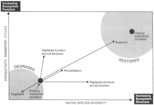
FIGURE 5-1 Restoration is dependent on ecosystem structure and function. A primary goal of restoration is to redirect the trajectory of a degraded area, in relation to both its structure and function. Restoration refers broadly the moving towards the upper right corner. Ecological restoration is represented by the historic watershed condition. SOURCE: Reprinted, with permission, from Williams et al. (1997). © 1997 by American Fisheries Society.
likely need to change and adapt over time if restoration efforts are to proceed. Because riparian areas represent an entire suite of organisms, physical features, processes, and functions, a species-only or single-process approach will likely fail to achieve a significant degree of restoration. For example, the reintroduction of an extirpated plant species into a degraded riparian area is likely to fail if the underlying causes of extirpation have not been addressed. Focusing on those human influences that affect multiple ecological processes is more likely to attain greater restoration of riparian habitat and species of interest.
Alternatives to Protection and Ecological Restoration
Across the United States, a large number of aquatic and riparian projects are implemented each year, many of them having “restoration” as one of their expressed goals. Although ecological restoration may be a nominally important objective of some projects, many others are simply altering aquatic and riparian
systems with little emphasis on understanding or attempting to benefit long-term ecological processes or functions (Goodwin et al., 1997); improvements in ecological functions are typically not specified nor necessarily expected. Terms such as creation, reclamation, rehabilitation, replacement, mitigation, enhancement, and naturalization have been coined to describe the wide variety of land management approaches (NRC, 1992, 1996). These approaches typically emphasize altering ecosystem components to serve a particular human purpose, but generally are not intended to restore the full suite of ecological functions that would normally be associated with a particular riparian area (Kauffman et al., 1997). Although these terms have different meanings to various disciplines (legal, political, and scientific), the appropriate characterization of riparian management options and goals is more than a matter of semantics. It is important to properly distinguish between a wide range of management approaches so that interested parties have realistic expectations regarding their potential outcomes.
Creation
Creation is the establishment of a new riparian system on a site where one did not previously exist; it is generally associated with the establishment of a “new” reach of stream. For example, the repositioning of a section of stream or river channel will inherently cause the “creation” of a new riparian area that may or may not be ecologically similar to the section of channel lost by such a repositioning. Often the newly created channel will be less sinuous than the original one and less likely to be hydrologically connected to former floodplains. In other instances, channels may have been unintentionally developed or created as a result of long-term land-use practices. As discussed in Chapter 3, conversion of native forests and grasslands to agricultural crops throughout much of the Midwest was commonly accompanied by altering field drainage patterns (e.g., tiling and ditching), such that new channels eventually developed. An extended network of intermittent and ephemeral streams has become established in many agricultural areas where they did not previously exist; many of these streams could support riparian plant communities.
Reclamation
Reclamation has traditionally been defined as the process of adapting natural resources to serve utilitarian human purposes (NRC, 1992). Historically, it often involved the conversion of wetlands and riparian areas to agricultural, industrial, or urban uses. More recently, however, reclamation has been defined as a process resulting in a stable, self-sustaining ecosystem that may or may not include some exotic species. The structure and functions of reclaimed sites may be similar, although not identical, to those of the original land (Jackson et al., 1995).
Rehabilitation
Rehabilitation implies rebuilding or making part of a riparian area useful again after natural or anthropogenic disturbances. For example, the mechanical excavation and reconfiguring of an eroding bank could represent rehabilitation. Although the resulting bank configuration might assist in retarding subsequent erosion, its configuration and other properties might be quite unlike that of a natural channel. Restoration of predisturbance processes and functions is neither required nor implied in the definition of rehabilitation; rehabilitation efforts typically do not focus on reproducing conditions characteristic of functionally intact riparian systems or on meeting regional ecological goals.
Mitigation
Mitigation is an attempt to alleviate some or all of the detrimental effects or environmental damage that arise from human actions. Mitigation is commonly used with regard to wetlands—e.g., the creation of a new wetland is often proposed as mitigation for natural wetlands that are to be impacted by dredging, filling, or other human alterations. However, constructed wetlands seldom display the full complement of structural and functional attributes of the native wetlands they replace (Quammen, 1986; Kusler and Kentula, 1990; NRC, 2001). Mitigation with regard to riparian areas focuses on minimizing potential detrimental impacts from a particular human action. For example, where levees may be needed along a river to protect human developments, mitigation might require the levees to be set back some distance from the channel edge to retain some riparian functions of the streamside vegetation and to maintain hydrologic connectivity of the near-channel floodplains and side channels. Where rip-rap is to be employed along a streambank, mitigation might require that measures be taken to ensure that riparian plants can become established and survive along the structure. In forested systems, large wood could be placed in channels in an attempt to mitigate the effects of prior harvesting practices that removed all trees along streams.
Replacement
Replacement represents the substitution of a native species or ecosystem feature with an alternative species (e.g., exotic species) or foreign object. An example would be the replacement of native conifers or deciduous trees with non-native species. Sometimes the replacement can be structural; for example, rip-rap may be used where floodplain or meadow streambanks have begun to erode because land uses have removed streamside vegetation or reduced the ability of the remaining vegetation to retard fluvial erosion. Replacement ap-
proaches are generally narrow in scope and seldom successful in promoting a wide range of ecological goals.
Engineered approaches that reconstruct or greatly modify a particular stream and its riparian system to meet specific human ideas regarding what they should look like or how they should function are also considered replacement. Such approaches are often employed in urban areas where significant alterations to a stream and riparian area have occurred and where the hydrologic regime has been significantly altered (e.g., where increased amounts of impervious surface contribute more surface runoff and higher pollutant loads to a stream). Although these designed systems may provide many benefits (e.g., stabilized channel morphology, permanent streamside vegetation), they seldom have the features of more natural streams and thus do not provide the full range of functions associated with natural systems.
Enhancement
Enhancement represents an attempt to accentuate or improve a specific component of riparian areas. Thus, enhancements may come at the expense of other components and may create conditions that are uncharacteristic of a natural riparian system. A widespread example is the employment of structures of various types and sizes in channels and on streambanks (e.g., log weirs, gabions, large rocks) to enhance fisheries habitat (e.g., Wesche, 1985; Hunter, 1991; Seehorn, 1992). These structures can alter streambank structure, sediment transport dynamics, and hydrologic connectivity with riparian vegetation, often resulting in disruption of riparian–stream linkages. Similarly, when spoils, rocks, or boulders are removed from streams and added to streambanks and floodplains to enhance local channel stability, conditions may no longer be suitable for the natural establishment of riparian vegetation or for adjustments in channel morphology in response to streamflow and sediment transport. In-channel enhancement projects are unlikely to provide long-term or sustainable improvements for riparian/aquatic systems (Platts and Rinne, 1985; Elmore and Beschta, 1989; Beschta et al., 1994).
Naturalization
Naturalization, an alternative to ecological restoration, attempts to accommodate watershed-scale human influences in environmental designs of channels by establishing stable, self-sustaining geomorphologic systems with abundant and diverse ecological communities that are fundamentally different from those that existed before. The concept of naturalization was developed for specific application to agricultural streams that have been significantly modified, often by deepening and straightening previously existing channels (Rhoads and Herricks, 1996). Where headwater channel gradients are low, as in the Midwest, such channelized and modified streams have developed relatively stable configura-
tions over many decades; the goal of naturalization would be to maintain that new stable configuration.
Naturalization assumes that the pristine stream network may not be the best restoration objective for stream management because (1) adequate information on the pristine state of streams is not available, (2) environmental conditions in most watersheds are far removed from the pristine state, and (3) restoration at the watershed scale is economically impractical. Because most streams in agricultural settings are not regulated by dams or lined with concrete, they retain some of their capability to morphologically adjust to changing flow and sediment regimes, implying there is some potential for these areas to support other riparian functions such as habitat provision. Management that might be used to achieve naturalization includes not only vegetated riparian buffers (discussed later), but also off-channel wetlands, side-slope reduction of streambanks, increased stream sinuosity, and other practices that provide improved ecological and water-quality benefits (Petersen et al., 1992).
The alternative approaches described above differ from protection and ecological restoration in their ultimate goals and consequently in the amount of ecological functioning that a degraded riparian area might eventually attain. While it is not the objective of this report to advocate ecological restoration as a goal for all degraded riparian areas, it is important to understand the trade-offs between restoring an area to full functioning vs. partial functioning. Much more important than the setting of a challenging goal (e.g., ecological restoration) is continual progress toward a more functional system. When conceptualized as a series of activities that improve both ecosystem structure and function, restoration can be monitored over time and at specific milestones. Box 5-1 illustrates the restoration of Bear Creek, Oregon—i.e., movement of this riparian area toward improved structure and functioning.
Passive Versus Active Approaches to Restoration
Once the necessary background information has been obtained for understanding the status, trends, and factors influencing a particular riparian area, perhaps the most critical step in undertaking restoration is to curtail those activities and land uses that are either causing degradation or preventing recovery. Such an approach is referred to as passive restoration (Kauffman et al., 1997). Removing human disturbances in degraded systems allows natural process to be the primary agents of recovery. Many riparian areas are capable of recovery following a reduction in or curtailment of human perturbations because the biota of these systems has evolved to reproduce and survive in an environment of frequent natural disturbances. In the absence of other types of management, natural disturbance regimes and ecosystem responses will dictate the speed of recovery for areas undergoing passive restoration (NRC, 1996).
|
BOX 5-1 Bear Creek provides a unique opportunity to observe the evolution of a riparian area over 21 years of changing management. It also demonstrates the resiliency of functioning riparian areas to management alternatives and high-flow events. Bear Creek is approximately 1,000 m (3500 ft) in elevation and located in the high desert of central Oregon. Although annual precipitation averages only 300 mm (12 in), the year-to-year variation in precipitation is quite high. Peak runoff from snowmelt typically occurs in mid to late February, and summer thunderstorms are common. Livestock have grazed the Bear Creek area since the late 1800s; the permitted use in 1977 was 75 animal unit months (AUMs) from April until September. Surveys during 1977 revealed that the Bear Creek riparian area totaled 0.95 ha/km (3.8 ac/mile) of stream (representing an average riparian width of less than 5 m (16 ft) on each side of the stream) and was producing approximately 225 kg/ha (200 lbs/ac) of forage. That meant that if livestock consumed all the available forage and used 365 kg/AUM (800 lbs/AUM), 1.6 km (1 mile) of stream was required to support one cow for one month. As shown in Plate 5-1, by 1977 streambanks were actively eroding, the channel was deeply incised, and riparian vegetation was sparse. Flows were frequently intermittent, and runoff events contained high sediment loads. The Bureau of Land Management (BLM) then changed the grazing rotation in the area such that in 1979 and 1980, the area was grazed for one week in September. From 1981 to 1984, none of the area was grazed. As shown in Plate 5-2, by May 1983, banks were stabilizing and the channel was narrowing and deepening. Sediment trapped by vegetation can be seen on the banks among newly emerging plants. Juniper trees in the floodplain seen in Plate 5-1 were cut down to see if this practice would affect willow reestablishment. (To date, willow reestablishment has been unsuccessful.) The large juniper indicated by the arrow was left, and it can be seen in the remaining photos. By comparing Plates 5-1 and 5-2, it can be seen that over the six-year period of controlled grazing and livestock exclusion, riparian vegetation increased, the channel narrowed and deepened, and channel stability increased. Sediment, trapped by vegetation, can be seen on the banks in the reestablishing riparian area. These results were the result of natural recovery of the riparian area once livestock were excluded. Active restoration techniques, such as channel grading and planting, were not used. During 1985, the pasture was divided into three pasture units, and controlled grazing was permitted from mid-February to mid-April. Vegetation was then allowed to grow to protect the stream system during the critical summer thunderstorm period and to provide livestock forage the following year. From 1983 to 1986, the channel continued to deepen and narrow, and nearly 460 mm (1.5 ft) of sediment was trapped on the floodplain because of increased riparian vegetation, which not only reduced channel scour but also reduced flow velocities and sediment transport capacity, as shown in Plate 5-3. Plate 5-4, taken in June 1987, shows the effects of a large summer thunderstorm and resulting flood event on the riparian area. Compared to 1986 (Plate 5-3), it appears that much of the riparian vegetation has been inundated with sediment. The main channel widened some, but it is still narrower than it was in 1977 (Plate 5-1), and the channel |
|
and the stream banks appear stable. There are obvious sediment deposits on the streambanks. By August 1987 (Plate 5-5), the riparian vegetation was recovering rapidly and was stabilizing sediment trapped during the flood event, although some bare areas were still present. By October 1998, 16 months after the June 1987 flood event, the riparian area appears to have fully revegetated (Plate 5-6). The floodplain now appears stable and has trapped over 600 mm (2 ft) of sediment since 1976. By 1989, the increased productivity of the riparian area permitted grazing to increase to 354 AUMs, nearly five times the 1977 allotment of 75 AUMs. This reportedly reduced the livestock permittee’s winter feeding costs by over $10,000 a year. Plate 5-7, taken in August 1994, shows the riparian area during a drought. Because of reduced channel flow, sedges and rushes seeking water occupy almost the entire channel. The formerly intermittent stream has become perennial because of increased infiltration and moisture storage in the reestablished riparian area. By 1995, beavers had returned to the watershed, presumably attracted by the improved hydrologic regime and increasing riparian vegetation. This is another possible indication of improved riparian functioning, as beavers usually avoid streams in poor condition. The dam building activities of the beavers will further stabilize the stream and increase water storage within the stream system. Plate 5-8 shows a newly established beaver dam slightly downstream of previous photos. By 1996, the riparian area had increased in size to 3 ha/stream km (12 ac/stream mile), and forage production had increased to 370 kg/ha (2,000 lbs/acre)—approximately a 10-fold increase since 1977. Sediment deposition in the riparian area raised the streambed by 0.75 m (2.5 ft), and channel storage increased eightfold to approximately 9,400 m3/km (4,000,000 gal/mile) since 1977. Stream length (sinuosity) increased by 11 percent, and rainbow trout returned to the stream for the first time in decades. In February 1996, the stream experienced another major flood caused by the rapid melting of the winter snow pack. As shown in Plate 5-9, the flood inundated a large portion of the floodplain. When the water receded, however, little damage was revealed, as shown in Plates 5-10 and 5-11, taken two and eight months later in April and October 1996, respectively. The established riparian vegetation was able to resist damage from this flood, protect the stream channel from scour, reduce flow velocities, and trap an additional 13 cm (5 in) of sediment in the floodplain. The Bear Creek project demonstrated the potential of passive restoration in a riparian area long degraded by overgrazing. In this case, total exclusion of livestock from the riparian area occurred for several years, followed by controlled late winter–early spring grazing from February 15 to April 15 once most of the riparian vegetation was reestablished. Livestock were excluded from the riparian area at all other times of the year. According to the BLM project manager, the timing and duration of grazing appeared to be more important than the number of livestock in maintaining the health of riparian vegetation once it had been reestablished. In addition, the most important factor in riparian area restoration was commitment by the operator to observe the livestock exclusion and the subsequent controlled grazing. Photos and project description provided by Wayne Elmore. |
Because passive restoration focuses on altering, reducing, or eliminating the primary causes or factors that have contributed to a degraded riparian system or have prevented recovery, its importance cannot be overemphasized. Passive restoration is the logical and necessary first step in any restoration program—and in many cases may be all that is required.
Although passive restoration is a relatively straightforward concept, it can sometimes be difficult to implement because doing so typically requires changing the types or extent of land or water uses within riparian areas or at other locations in a given watershed. Existing land uses that have occurred over many years or decades may be difficult to change. Often the most significant barriers to passive restoration are social, cultural, and political rather than scientific or biological. However, bypassing this step represents a major strategic flaw in any restoration program and may ensure the inevitability of project failure if ecological restoration is the goal.
In recent years, an increasing number of passive restoration activities have been implemented in portions of the American West. For example, most western states (and some eastern states) have implemented forest practices rules on industrial forestlands that identify riparian protection as an important management objective. Such rules often identify the dimensions of required no-harvest buffers and other practices (e.g., directional felling, limitations on ground skidders) designed to reduce and minimize forestry impacts to riparian areas. As discussed in Chapter 4, federal agencies [e.g., U.S. Forest Service (USFS), Bureau of Land Management (BLM)] have implemented a system of riparian reserves that often provide full no-harvest protection for areas one to two site-potential tree heights from a stream. In grazed areas, extended periods of non-use or exclosure fencing have begun to occur in some riparian areas on both federal and private lands. In the Mono Basin of northeastern California, the return of flows to Rush and Lee Vining Creeks and the removal of grazing along these streams by the city of Los Angeles, after a protracted legal battle, have resulted in a major recovery of riparian vegetation and functioning. (As of yet there has been little monitoring or research to document the ecological changes that are occurring as a result of these improved riparian management practices.)
After passive restoration is implemented, a riparian area may remain in an ecological condition that is significantly different from that of a comparable reference site, particularly if its inherent capacity to recover has been severely influenced or lost. To improve the likelihood of achieving restoration in such situations, active manipulations, herein referred to as active restoration, may be needed. Active restoration attempts to restore a degraded or dysfunctional riparian area by combining elements of natural recovery with management activities directed at accelerating the development of self-sustaining and ecologically healthy systems (NRC, 1996; Kauffman et al., 1997). This requires not only an understanding of the complex processes and linkages between the biotic and
physical components of intact systems, but also of the range of active management practices that might be successfully implemented.
Factors that may prevent the return of a degraded riparian area to a more natural dynamic one via passive restoration include species extinction, exotic species invasion, significant structural modifications, and continued alteration of hydrologic flow regimes. Although some of these factors can be addressed via active restoration, others can be sufficiently severe in their magnitude, persistence, and spatial extent that full ecological restoration may not be technologically or economically feasible. Nonetheless, restoration can still achieve ecological improvement of a system so that specific ecosystem features (e.g., water quality), biotic species (e.g., endangered species), or channel morphology (e.g., reestablishment of historical channels) are improved.
Regardless of whether passive or active restoration is chosen, riparian and watershed activities that do not address the recovery of multiple ecosystem linkages and functions are likely to have only limited success, they may have no effect, or they may even exacerbate ecosystem degradation. Continued degradation following the implementation of restoration measures could occur because of an inadequate scientific basis for the established goals, institutional constraints such as insufficient funding or funding at an inappropriate time, or severe environmental conditions during the early phases of a restoration project (e.g., exceptionally large floods, drought, fire). Unfortunately, continued degradation not only suppresses the recovery of ecological functions, but it may further limit the capability of a riparian system to be restored.
The alteration and degradation of riparian areas at both local and regional scales generally reflect land uses occurring over extended periods. Similarly, the recovery of riparian areas after the cessation or removal of perturbations will require time. Time requirements for the recovery of a degraded riparian system are seldom mentioned in restoration projects. Some riparian functions can recover relatively rapidly, while others require long periods to achieve their full potential. Figure 5-2 illustrates the projected recovery rates, under passive restoration, for various components of riparian areas associated with salmonid habitats in the Interior Columbia River Basin. While the exact timing of individual features’ recovery may vary by location, watershed, or region, the overall pattern is one of increasing functional interaction among riparian vegetation, channel morphology, and aquatic and riparian habitats over time.
Potential Conflicts Between Riparian Restoration and Other Management Goals
Given that human use of riparian areas has often been at the expense of maintaining their ecological processes and functions, attempts at improving and restoring riparian functions may encounter some degree of social, political, or
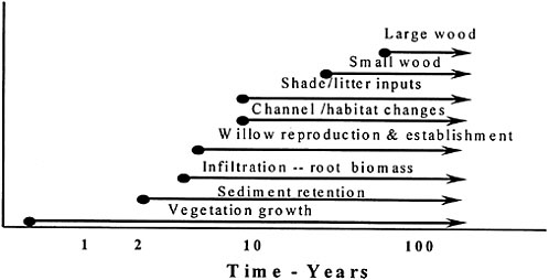
FIGURE 5-2 Projected recovery times of selected leading-edge and keystone components of salmonid habitats in the Interior Columbia River Basin following the cessation of activities causing degradation or preventing recovery (passive restoration). SOURCE: Reprinted, with permission, from Beschta and Kauffman (2000). © 2000 by American Water Resources Association.
institutional opposition. The following are some of the issues that may affect whether and how quickly restoration efforts move forward.
Short-term versus Long-term Restoration Goals
In nearly all restoration efforts, one is typically faced with trying to balance short- and long-term goals. For example, former riparian plant communities may have experienced a loss in species diversity and cover because of grazing or conversion to agricultural crops. In the first instance, many of the native plants may still be present, but their abundance and growth have been greatly curtailed. In the second, the original riparian vegetation may no longer exist except in small, isolated areas. Halting those land use practices causing degradation or preventing recovery, i.e., passive restoration, could be accomplished by removing grazing animals from the riparian areas in the first instance and by no longer cropping to the edge of the stream in the second. Vegetation in the previously grazed area would likely recover relatively quickly if most of the native plants were present. For the agricultural setting, however, it may be necessary to reintroduce native plants to help “jump start” native plant communities. Although both approaches would be directed at a reestablishment of native plant communities and their attendant physical, biological, and chemical processes, recovery in the cultivated agriculture setting would likely take longer and require some form of
active restoration. In addition, where channel morphology has been altered via management practices, the recovery of channel dimensions and form is not likely to occur with the same rapidity as that of vegetation. Thus, practitioners involved in restoration efforts should realize that the short- and long-range goals of any restoration effort will be met sequentially if the restoration approach is ultimately successful.
Small-Scale versus Large-Scale Perspectives
Land managers typically view riparian issues at small scales—i.e., the size of their property or management unit slated for restoration. In doing so, they may fail to realize the extent to which their riparian areas have been altered over time, the role of off-site factors, or the impact that their management decisions can have on other areas. To help land managers better understand riparian issues, the condition of their land, and the potential for ecological improvement and restoration, a larger-scale landscape perspective is often required. Landscape assessments can be undertaken to provide multiple landowners with potential strategies for improving the ecological and social values of their specific riparian areas. It is also at these larger scales that scientific input can offer a crucial perspective regarding the magnitude of problems and the potential for improvement. Where monetary resources for restoration efforts are limited, having a large-scale perspective will allow for more effective allocation of resources to accomplish the greatest good. Watershed councils, state and federal agencies, and other groups are often of major assistance in developing basinwide perspectives that are useful to various landowners and land managers as they engage in riparian improvement and restoration across a given drainage basin.
Private Lands versus Public Resources
The vast majority of the nation’s riparian lands are in private ownership. These lands provide a wide variety of economic and social benefits to landowners. However, many of the benefits derived from functional riparian areas also cross into the public domain. For example, intact riparian forests generally ensure high levels of stream shading and tend to reduce stream temperatures during summertime. Although the incremental impact to summertime stream temperatures is likely to be small if a single landowner were to harvest the riparian forest or convert it to another use (e.g., grazing, agriculture), the cumulative effect on water quality can be considerable if multiple landowners temporarily or permanently remove their riparian forests.
The regulation of instream water quality by states may affect landowners’ management of their riparian areas (although the exemption of nonpoint sources of pollution from permit requirements means that many land uses are not directly regulated). In forestry, public concern about water quality has increasingly been
codified into forest practice rules that, on a state-to-state basis, vary in the level of riparian protection and enforcement. Similarly, public concerns about fisheries and wildlife habitats may affect the management of riparian areas on private lands. The extent to which the public’s need or desire to maintain and protect public resources (e.g., water quality, fish and wildlife habitat) outweighs landowners’ rights to manage and alter riparian systems continues to be a hotly contested issue. In some instances, the core issue is the extent to which restrictions can be placed on traditional activities on private lands now understood to result in significant ecological damage.
Riparian Area versus Human Water Needs
One point of conflict in many western states regards the water needs of riparian vegetation versus those of humans. Because they represent sites of higher moisture availability than upslope terrestrial environments, riparian areas have relatively high evapotranspiration rates. In the arid and semiarid regions of the western United States, woody plant communities found along streams often have extensive root systems that allow them to extract water from the water table or from the capillary fringe immediately above (Brooks et al., 1991). Active removal and eradication of riparian plant communities in the name of water conservation has been a common practice in these areas, although actual water savings have rarely been quantified. In fact, the presumed water savings from the removal of riparian vegetation stands in stark contrast to reports that document the loss of perennial flow from rivers, streams, and springs when riparian vegetation is removed (e.g., Hendrickson and Minckley, 1984). Clearly, a simple projection of potential evapotranspiration gains associated with the removal of riparian plant communities is not adequate for evaluating the merits of such projects.
Reintroducing historical overbank flows at their customary timing and frequency of occurrence as a restoration strategy may sometimes lead to conflict with the water needs of human populations. Although research in both humid regions (Cummins and Dahm, 1995; Dahm et al., 1995) and arid regions (Lieurance et al., 1994; Molles et al., 1995, 1998) has shown beneficial responses of riparian areas to restored flooding, the water costs of such strategies have not been carefully documented. That is, how water availability for other purposes (e.g., hydropower generation, irrigation withdrawals, municipal or industrial use) changes when such approaches to restoration are used has seldom been quantified. Larger-scale use of restored flooding depends on assessing the amount of water that will be required and convincing multiple local, state, and federal agencies and various water users that the activity is sound management policy. Floods are not only one of the most common large natural disturbances that occur in the United States, but they are also one of the most costly in terms of property damage and loss of human life. A major challenge with such restoration efforts is to reestablish enough of the unregulated high-flow dynamics (magnitude, fre-
quency, duration, and timing) so that characteristic riparian plant communities can be restored while not substantially increasing the risk to property or human life.
Eliminating exotic vegetation in riparian areas and reestablishing native plant communities is another approach to riparian restoration that can sometimes lead to conflicts between interest groups. For example, controversy marks recent proposals for biological control of exotic saltcedar in riparian areas of the western United States. In this case, one group of managers within the U.S. Fish and Wildlife Service pressed for release of insects to control invasive saltcedar populations (DeLoach, 2000). Meanwhile, a second group within the same agency worked to block the release of these biological control agents in order to protect nesting habitat for the southwestern willow flycatcher, a federally listed endangered species, which actively nests in pure stands of saltcedar in some areas (Leon, 2000).
* * *
Potential conflicts between contemporary land uses and the changes needed for improving the nation’s riparian resources encompass the full range of land uses, water resource developments, and management policies. At least some of the current land and water use practices and management policies were initiated long ago when the nation was going through a period of expanding occupancy and settlement. Land development continues today under a policy climate that often encourages alteration of natural systems. Unfortunately, such policies were formulated and implemented during a time when impacts on riparian areas and their stream systems were not widely understood.
Because many of the options for improving riparian systems across watersheds encompass a wide range of individual and societal values, there is a great need to engage various stakeholders in broad-scale and collaborative restoration efforts. The potential success of collaborative efforts rests firmly on two foundations: credible scientific information and broadly inclusive participation where the full spectrum of perceptions, interpretations, claims, and contentions can be openly discussed, critiqued, and challenged. As a process for finding areas of agreement amongst all stakeholders (scientists, land managers, regulators, and the public), such deliberations need to ensure inclusiveness, openness, safety of expression, and respect for divergent views and positions. Although such an approach takes time and may not lead to full consensus, it is only through such a process that restoration can truly be a collaborative effort with substantive public support (Committee of Scientists, 1999).
Riparian Management as Part of Watershed Management
Because riparian areas are integral components of larger watersheds (drainage basins), management of riparian areas should attempt whenever possible to be incorporated into larger-scale watershed management plans. Watershed man-
agement refers to the managing of water resources (both surface water and groundwater) in a watershed or river basin context (rather than in a political or jurisdictional context) (NRC, 1999). Although instigated in the early part of the twentieth century, watershed management has found renewed support in the last 15 years for primarily water quality and ecological reasons (Adler, 1995). It is a holistic approach that addresses multiple sources of pollution within a watershed, such as urban and agricultural runoff, landscape modification, depleted or contaminated groundwater, and introduction of exotic species, to name just a few. As articulated by the U.S. Environmental Protection Agency (EPA), the watershed approach is a coordinating framework for environmental management that focuses public and private sectors on addressing the highest priority problems within hydrologically defined geographic areas (EPA, 1995). It targets those issues not adequately addressed by traditional point source programs—programs that for the most part have failed to protect watersheds from the cumulative impacts of multiple activities.
Although watershed management may vary in terms of specific objectives, priorities, elements, timing, and resources, it is based on the following principles, which necessarily should also characterize riparian area management:
-
Partnership. All stakeholders affected by management decisions should be involved throughout watershed management and should shape key decisions. This ensures that environmental objectives are integrated with economic, social, and cultural goals. It also provides those who depend upon the natural resources within watersheds with information on planning and implementation activities.
-
Geographic Focus. Activities should be specific to geographic areas, typically the areas that drain to surface waters or that recharge or overlay groundwater or a combination of both.
-
Science-Based Management. Collectively, watershed stakeholders should employ high-quality scientific data, tools, and techniques in an iterative decision-making process including (1) assessment and characterization of the natural resources, (2) goal setting and identification of objectives based on the needs of the ecosystem and stakeholders, (3) prioritization of identified problems, (4) development of management options and action plans, (5) implementation of management options, and (6) effectiveness evaluation and plan revision (NRC, 2000).
Coordination of the many public and private interests implicated in watershed management is a major challenge. Institutional mechanisms for such coordination do not yet exist in most places, and where they have been developed, their effectiveness has been highly variable (Scurlock and Curtis, 2000). Fortunately, the involvement of stakeholders in watershed management has been aided by the emergence of local watershed groups—encouraged, in part, by EPA’s emphasis on watershed approaches, but motivated also by rapidly developing ecosystem
science and by frustration with the jurisdictional and programmatic piece-mealing of the landscape (Natural Resources Law Center, 1996). Although watershed groups form because of some specific, broadly shared concern, protection of riparian areas has not, by itself, been a primary or common focus. Rather, such things as improvement of water quality and protection of a fishery have been the motivating factors (Kenney et al., 2000). Yet it is precisely because of their important role in achieving many distinct objectives, such as healthy fish and wildlife habitat or floodplain management, that protection and restoration of riparian areas should be approached on a watershed scale, even though this may increase the complexity and timeline of the project.
Box 5-2 presents two examples of where riparian area management was incorporated into larger watershed management efforts. In the first case (the San Pedro Riparian National Conservation Area), it was recognized that restoration of the riparian area would not succeed without a more holistic understanding of the causes of degradation—most of which are outside the riparian area. In the second case (the Model Watershed Project in Idaho), activities in the riparian area were determined to be critical to achieving the overall goals of watershed management.
TOOLS FOR ASSESSING RIPARIAN AREAS
For decision-makers to be effective in managing riparian areas, they need information on the status and condition of these areas. The identification of riparian areas is a first step in accumulating information about their quantity and quality. Where they have been highly degraded, it may be difficult to identify riparian areas by remote sensing or even ground-based surveys. It is similarly difficult to identify wetlands that have been effectively drained. Yet their recognition is important precisely because former wetland areas are among the best opportunities for restoration. The same principle applies to riparian areas.
A wide variety of tools are available for assessing the condition of riparian areas. The assessment tool chosen will depend on the objectives of the program for which it is to be applied. For example, a program designed to identify priority areas for restoration might find useful a large-scale watershed assessment approach, such as the Hydrogeologic Equivalence or the Synoptic Approach discussed below. These approaches generally consider the existing condition of all riparian areas, the cumulative length of the various stream orders, and longitudinal connections that are necessary for migrations of fish and other organisms. For smaller-scale projects such as restoration of a reach of riparian corridor, knowledge is needed about what types of vegetation should be planted, the appropriate channel capacity for the stream, and the width of the riparian area necessary for carrying out various functions. In tracking the progress of individual restoration projects, detailed information on hydrology, seedling survival, and animal recruitment might become components of an assessment.
|
BOX 5-2 San Pedro Riparian National Conservation Area Because of the unique quality of its riparian habitat and bird populations, Congress designated a 40-mile segment of the upper San Pedro River in Arizona as a National Conservation Area in 1988. Funding allowed the buy-out of irrigated farmlands within the area and retirement of the associated water rights. Despite this designation and the use of passive restoration, studies have documented a continued decline in stream flows and in the health of riparian vegetation. The San Pedro originates in Mexico and flows north into Arizona to its confluence with the Gila River. In most segments the San Pedro is a perennial stream, but surface flows sometimes disappear—especially in very dry years. Flood flows in the San Pedro are the product of large rainfall events, usually in late summer but sometimes in the winter. Base flow is the product of groundwater discharge—primarily from the more deeply underlying regional aquifer rather than from the shallow alluvial aquifer. Water use in the Mexico portion of the watershed is primarily for irrigation and includes significant groundwater pumping. Water use, also via groundwater pumping, in the southern Arizona segment is primarily for the needs of a military base (Fort Huachucha) and for urban growth in and around Sierra Vista (Commission for Environmental Cooperation, 1998). There is little doubt that riparian vegetation along the San Pedro will continue to decline unless ways can be found to limit additional groundwater depletions and, possibly, recharge the regional aquifer—actions that must be taken well outside the riparian |
In general, complex restoration projects dealing with multiple impacts and a variety of riparian and wetland types might be better served with a unique assessment approach tailored to site-specific peculiarities. At the watershed scale, this could involve a large research and data gathering component, followed by modeling and validation, and it would include input from stakeholders in the region. An advantage of costly and involved large-scale assessments such as this is that the information is often transferable to similar physiographic regions.
This section focuses on standardized approaches that can be applied in a relatively short period (rapid assessment) and that do not require long-term training for practicing environmental professionals. Assessments fall into two basic categories: (1) functional assessments that estimate probabilities that a riparian function exists and (2) reference-based methods that estimate ecosystem condition. Rapid assessment methods for evaluating ecosystems have undergone dramatic development in the past three decades. Of particular relevance for riparian areas are methods that were developed for assessing wetlands, to which there has been considerable attention as a consequence of government regulatory programs. However, this section also evaluates methods developed specifically for riparian areas. It should be noted that there are various instream flow assessments
|
area of interest. No acceptable solutions have as yet emerged, but a watershed partnership of all the affected interests (Upper San Pedro Partnership) has formed with the goal of working out an agreement respecting water use. Significant progress has been made in water conservation practices at Fort Huachucha and in Sierra Vista. Although other actions still will be necessary to ensure the long-term health of the riparian system along the San Pedro, it is clear that no one entity can make this happen. Model Watershed Project The Model Watershed Project in Idaho started in 1992 to address local factors related to the decline of salmon and steelhead runs, particularly problems of fish habitat and passage related to irrigation water use. The project area encompasses the Lemhi River, the Pahsimeroi River, and the East Fork of the Salmon River in Idaho, which have a combined drainage area of approximately 2,735 square miles. The purpose of the project is to provide a basis of coordination and cooperation between local, private, state, tribal, and federal fish and land managers, land users, landowners, and other affected entities to protect and restore anadromous and resident fish habitat. Watershed-wide, the land area is approximately 88 percent federal and 12 percent private. However, the stream corridor, which is most influential in providing salmon habitat, is 90 percent private and 10 percent federal. Beef cattle production is the dominant economic activity, and hay is the primary crop. As analysis of fish habitat conditions proceeded, it soon became evident that protection of riparian areas was essential. Because the analysis involved public/private partnerships, local landowners were willing to participate. Construction of fences creating a riparian buffer zone for grazing management has been a primary focus. In addition, projects have focused on streambank stabilization and riparian vegetation plantings, as well as instream structure work. |
that target aquatic ecosystems. Although some of these methods take the condition of riparian areas in account and thus may be valuable for assessing riparian areas—such as the Stream Visual Assessment Protocol (USDA NRCS, 1998)—they are not the focus of this section.
General Characteristics of Assessment Tools
Need for Classification
Within a geographic region of interest, classifying riparian area types is one of the first steps in organizing information. The highest order of classification separates riparian areas by rivers, lakes, and estuarine/marine settings. Within each of those categories, further classification should recognize the amount of natural variation so that variation related to degraded conditions can be more easily identified. Most assessment methods discussed below use classification to identify what portion of the landscape is being evaluated and whether the riparian component needs to be further subdivided into more relatively homogeneous areas (although classification is not emphasized in the description of any particu-
lar procedure). Assessments done with little regard for initial classification are not likely to be successful.
Rather than adopt a classification system for use throughout the United States, regionally developed classifications may be more appropriate. Resource managers may already be familiar with them, thus reducing the time that otherwise would be used to create, learn, and adopt a new system. If no appropriate classification of riparian areas exists for the region, a preexisting classification from elsewhere might be adopted. It is important that the classification not rely exclusively on vegetation because vegetation is commonly modified by human activity. Rather, the underlying template for classification should be based on geomorphology and hydrology. Classifications should not be restricted to channel morphology, which is only one part (albeit a very important one) of riparian areas. Methods that rely on channel forms (e.g., Rosgen, 1995; Montgomery and Buffington, 1997) can be utilized where they are a critical feature of riparian areas (as described in Box 5-3). Other classification features that have been used in the past include stream order, stream slope, valley width, drainage basin size, and underlying lithology. Ideally, one would use a hierarchical approach that first places adjacent waterbody type (river, lake, estuarine/marine) at the highest level and vegetative cover (or lack of it) at the lowest level, that would have the flexibility of accommodating new information, and that would recognize fluvial and geomorphic forces as principal organizers of riparian systems (Brinson, 1993). Altered riparian areas should not be identified as core riparian classes, but rather recognized as departures from one of the established classes of riparian areas. This would be consistent with a restoration approach that uses relatively unaltered riparian areas as targets for restoration (NRC, 2001).
Reference Sites
Reference sites ideally represent relatively large and intact riparian systems that are self-sustaining and have not been markedly influenced by anthropogenic impacts. Their identification is crucial to the restoration of riparian areas for a number of reasons. First, sites with minimal alterations illustrate the natural interactions of hydrologic processes, geomorphic setting, and vegetation dynamics. Indeed, much of our understanding of ecology has been derived from studies of intact ecosystems. Second, to the extent that these sites can be placed in a successional sequence, they may be used effectively for insights into restoration goals. These sites provide excellent opportunities for locally “grounding” the available science, thus providing a knowledge base important for addressing restoration needs. Finally, reference sites can serve as demonstration areas where scientists, managers, regulators, and interested citizens can interact on a common footing when addressing restoration needs and priorities and the potential for successfully attaining restoration goals. Several of the assessment tools discussed in this section require identification of reference sites as a preliminary step.
Obtaining information on undisturbed riparian areas is not always easy or possible. However, through the use of Government Land Office records, historical vegetation surveys, soil maps or profiles that delineate floodplains, chronosequences of aerial photographs, geomorphic assessments of channel conditions and fluvial landforms, and other sources of information, the nature of intact riparian areas can often be revealed. Thompson (1961) provides an excellent example of this reconstruction for the riparian areas of the Sacramento Valley in California. Today these areas bear absolutely no resemblance to their former condition of marshes and streamside forests, the latter of which were sometimes several miles wide. Without some sense of the conditions and characteristics of the natural riparian systems prior to human intervention, it is not possible to evaluate project goals and determine the general direction of change that is needed for recovery.
Natural disturbances must be recognized as a fundamental property of riparian areas and must be accounted for by reference sites. The range of variation arising from natural causes such as climate, topography, and geomorphology can be assessed by considering a number of individual sites within riparian classes. This range should include the normally encountered differences in geomorphic and hydrologic conditions, as well as natural disturbance regimes that result in successional stages within a riparian class. A second source of variation important for effective restoration and other management programs is that arising from human-induced alterations. Thus, altered sites should become part of the reference system so that the full range of variation—including both natural variation and that associated with anthropogenic sources—is taken into account. It is particularly important to choose sites impacted by activities that will be common targets for restoration. This ensures that the reference system identifies what altered and degraded riparian areas might evolve toward if the appropriate restoration approaches are undertaken. If the degree or extent of riparian degradation relative to that of an appropriate reference site is severe, recovery is unlikely to be quickly or simply achieved.
Although there are no fixed protocols for setting up a reference system, one guideline is to choose a relatively homogeneous array of sites in terms of climate, stream order, species composition, and disturbance regimes. Where such sites are abundant, the task of capturing natural variation is relatively easy. Conversely, where unaltered sites are infrequent, small, or fragmented, one may have to rely on historical data and descriptions or on information gathered at similar sites outside the geographical region of interest. Even less-than-ideal reference sites can provide important information on species composition and structure of plant communities, frequency of inundation, and other characteristics.
Once a reference system is established, it becomes a valuable asset for restoration programs. Its value would be enhanced if reference sites were protected by acquiring covenants or conservation easements that ensure the perpetuation of natural disturbance regimes (Brinson and Rheinhardt, 1996). Restoration projects
|
BOX 5-3 Methods for classification of natural channels across a wide array of landscapes may have utility in the assessment riparian areas because channel types influence processes within riparian areas such as sediment transport and deposition, flooding frequency, and flow dynamics. The simplest classification is the division of natural channels into braided, meandering, and straight channels by Leopold and Wolman (1957). Rosgen (1995) distinguished eight primary stream types in a classification that emphasized dimensional measurements such as number of channel threads, entrenchment ratio, width-depth ratio, and sinuosity (Figure 5-3). Montgomery and Buffington (1997) defined seven channel types based on similar criteria but were more forthright in recognizing the qualitative decision rules needed (Figure 5-4). 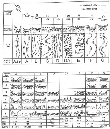 FIGURE 5-3 Rosgen Stream Classification. SOURCE: Reprinted, with permission, from Rosgen (1995). © 1995 by Wildland Hydrology. |
|
nel classification. In addition to the longitudinal and lateral gradients, vertical gradients beneath the channel and floodplain must also be considered (Stanford and Ward, 1993). Subsurface strata of granular material of highly variable texture represent the legacy of deposition and erosion in past times. River water penetrates those bed sediments and mixes with groundwater, creating distinct zones of biogeochemical reactions and habitats for certain aquatic insects and other organisms that live in subsurface environments. Riparian area classifications must therefore be extended to include a number of new variables, such as the size and hydraulic properties of alluvial aquifers, that are typically not considered in standard channel classifications. |
themselves may become “standards” to which other projects can be compared, especially those that have matured and succeeded in responding to natural perturbation regimes. For the same reason, much can be learned from unsuccessful restoration projects. Both contribute to a system of reference sites in ways that would be lacking if only unaltered sites were utilized.
Information Needs for Riparian Restoration
History of Resource Development. Because many changes to riparian systems occurred prior to the current generation of landowners and managers, understanding historical trends at both local (e.g., stream reach, valley, watershed) and regional (e.g., across large watersheds or ecoregions) scales can be critical for developing restoration plans. Such information is essential (1) for understanding the present status and trends of existing riparian systems, (2) for identifying possible management practices or forms of resource development that have contributed to existing riparian conditions or have prevented recovery, and (3) for developing effective restoration strategies.
If the historical causes of riparian degradation are not known or have been incorrectly assessed, attempts at restoration may be ineffective or misdirected and opportunities for riparian improvement lost. For example, although the planting of willows on sites for which they are not adapted provides temporary satisfaction in that a revegetation effort was undertaken, such planting is likely to have little effect (either positive or negative) on the long-term recovery of a particular riparian system. In other instances, willows may have been planted on appropriate sites, but if continued ungulate grazing (the original cause of willow extirpation) has not been modified, the opportunity for successful regeneration may be lost. In yet other instances, logs and boulders may be added to channels and streambanks in an attempt to replace lost structural elements. Although such an approach may have some basis in forested riparian systems, its application to streams in many meadow systems of the western United States or prairie systems
in the Midwest represents a misinterpretation of restoration needs. In these examples, the approach taken may not alter the causes of degradation—even though they may entail a major expenditure—and are likely to provide little prospect of improvement. Hence, understanding historical patterns of resource development and causes of degradation is extremely important where ecological recovery of riparian systems is the primary goal.
Hydrologic Regime. Understanding the characteristics of natural flow patterns—flow frequency, magnitude, duration, and timing—associated with specific riparian areas can be a crucial component of restoration where such flow regimes have been previously modified (e.g., because of dams, other water resources development, or extensive land modification). An important restoration goal may be reestablishment of a streamflow regime that emulates the temporal dynamics of an unaltered system and provides hydrologic connectivity to remaining floodplains and riparian landforms (Hill et al., 1991; Whittaker et al., 1993; Rood et al., 1999; Rood and Mahoney, 2000). For many floodplains, an understanding of subsurface hydrology and geologic stratigraphy is also critical (Jones and Mulholland, 2000; Woessner, 2000).
In some cases reestablishing the hydrologic regime will not be sufficient to restore degraded riparian areas, necessitating a better understanding of the links between flow regime, sediment dynamics, and vegetative growth. This is the case where hillslope or channel erosion processes remain altered in spite of attempts to return natural flows. For example, if accelerated surface erosion or landslides are occurring on upslope areas and the resultant sediments are transported to riparian areas, simply maintaining a natural hydrologic regime may be insufficient to restore a riparian system.
Channel incision and widening (as a result of a variety of land-use practices) and dams that have reduced the magnitude and frequency of high flows can curtail overbank flows, which typically ensures the loss or decline of riparian vegetation. Information on historical conditions of overbank flood events is needed to make decisions about whether healthy riparian plant communities can be reestablished and whether a long-term process of bank-building and channel aggradation may be an achievable restoration goal. Where channel incision or widening has been relatively large, these effects may not be easily reversible.
Soils and Landforms. Soils and landforms can provide important insights into the historical condition of their associated riparian areas. For example, floodplain soils that have developed from overbank flows over the millennia provide a long-term ledger of past hydrologic disturbance regimes and their resultant riparian systems. Even where vegetation has been largely modified, removed, or replaced by various land uses, residual soil properties (e.g., mottles, gleying, organic matter content, soil texture and structure, redox potential) can provide important clues regarding soil development processes and conditions that were
prevalent prior to the effects of Euro-American land uses. Soil texture is particularly important as it tends to indicate the prevailing hydraulic conditions at the time of deposition: clay particles are indicative of ponded water, silts of slow-moving water often across a vegetated surface, and sands/gravels of a relatively high-energy environment. Such information affords insight into how these systems may have formed and functioned in the past, the degree to which they have been changed by human activities, and the potential for restoration of degraded systems.
Vegetation. Although there is a great deal of information on the ecological roles of riparian vegetation (Brinson et al., 1981; Salo and Cundy, 1987; Williams et al., 1997; Koehler and Thomas, 2000; Verry et al., 2000; Wigington and Beschta, 2000), there is limited information in the scientific literature on holistically restoring degraded riparian vegetation. Many restoration efforts are simply agronomic projects that consist of planting selected species. Projects that ignore fundamental changes in hydrologic disturbance regimes or other factors that have altered site conditions are unlikely to lead to ecological improvements. Understanding not only the functions that specific species and groups of species perform, but also the hydrologic and edaphic requirements for their successful establishment and growth (e.g., Kovalchik, 1987; Law et al., 2000), is fundamental to any restoration project targeting riparian plant communities. In addition, the underlying causes of vegetation loss must be addressed. For example, attempts to restore native shrubs and other woody species in riparian areas are not likely to be successful if the natural hydrology is not restored or the area continues to experience heavy browsing pressure from domestic or wild ungulates.
Large-Scale Frameworks
Restoration ecologists have become increasingly aware of the need to conduct restoration activities within a context larger than the restoration project itself. This emphasis is particularly vital for riparian areas because they are so well integrated into the landscape by connecting uplands with aquatic ecosystems and creating corridors between high- and low-order streams. Factors that occur beyond the boundary of the site that are relevant to site-specific restoration include the nature and intensity of human activities in the watershed (Kershner, 1997), the potential for biological invasions, and the number of ecosystem types and landforms, to name a few (Aronson and LeFloc’h, 1996).
Two methods are available for organizing large-scale information—Hydrogeologic Equivalence and the Synoptic Approach—that deal explicitly with these landscape-level properties of wetlands and riparian areas. Both assessments were developed from the recognition that the condition and functioning of wetlands and riparian areas are in many cases driven by conditions upslope or upstream. Neither approach is an assessment of specific sites, but rather is a landscape-scale
assessment that would include riparian areas. Both approaches are particularly relevant for riparian management because they force a big-picture view that is helpful for planning, prioritizing, and funding restoration efforts. Consequently, they should be conducted prior to implementing smaller-scale assessments.
Hydrogeologic Equivalence
As discussed in Chapter 2, riparian areas vary in their primary source of water, underlying lithology, and inundation frequency. For example, those associated with ephemeral streams receive principally overland flow from adjacent uplands, while those associated with higher-order perennial streams also receive substantial water from groundwater discharge and overbank flow from upstream sources. Given the substantial variation that occurs within a watershed, Bedford (1996) introduced the concept of Hydrogeologic Equivalence [adapted from Winter and Woo (1990) and Winter (1992)]. The approach provides a framework for evaluating the distribution of wetlands at the landscape scale and for gaining insight into how landscape properties control hydrology and water chemistry. The same approach can be used for riparian areas. An assumption of maintaining Hydrogeologic Equivalence is that sources and flow paths of water determine the geographic distribution of riparian areas and wetlands at large scales—an assumption that appears to be well grounded in science (Winter and Woo, 1990). It is a logical extension of the reference concept, but applied at landscape scales rather than to individual sites.
The Hydrogeologic Equivalence concept recognizes that landscapes have developed and maintained different frequency distributions of wetlands and riparian areas with particular “hydrogeologic settings.” Such settings may represent desirable endpoints for ecological restoration at a watershed scale. These hydrogeologic settings reflect not only regional climate, but also surface relief, slope, hydrologic properties of soil, and underlying stratigraphy. Information available at landscape scales is increasingly accessible in the form of topographic maps from which the position of riparian areas can be calculated (e.g., headwaters vs. valley bottoms) and aerial photographs from which surface connections can be identified (Bedford, 1999). Once the hydrogeologic settings of a landscape in its pristine condition are determined, the biological and functional attributes of riparian areas can be inferred from the diversity of hydrogeologic patterns.
The approach provides a basis for determining the large-scale changes in wetland or riparian distribution over time and a template for evaluating mitigation strategies designed to replace wetlands and riparian areas that have been lost. It evaluates whether the restored system will be hydrogeologically equivalent to the original, relatively unaltered system. A study that applied the approach in an urbanizing area found that riverine wetlands (i.e., riparian areas) being lost through various modifications were being replaced through compensatory mitigation by small, isolated, deep depressions (Gwinn et al., 1999). This shift in the
distribution of wetland types (see Figure 5-5) was not achieving the goals of Hydrogeologic Equivalence.
From a practical perspective, riparian restoration efforts would be most successful if they use these hydrogeologic settings as guides for deciding what kinds of restoration should occur and where on the landscape they should take place. Still uncertain is how progressive changes in land use constrain the capacity of a watershed to maintain the original distribution of hydrogeologic types.
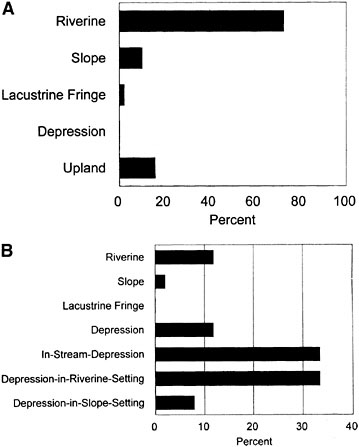
FIGURE 5-5 Comparison of wetland types before (A) and after (B) mitigation construction activities in the urbanizing region of Portland, Oregon, between 1981/1982 and 1993. Riverine wetlands show a reduction from (A) greater than 70 percent to (B) less than 15 percent of the total number of sites (45) in the inventory. SOURCE: Reprinted, with permission, from Gwinn et al. (1999). © 1999 by Dr. Douglas A. Wilcox, Editor-in-Chief, Wetlands.
Synoptic Approach
Originally developed for wetlands, the Synoptic Approach deals with cumulative impacts (Liebowitz et al., 1992). It is intended to provide resource managers with a landscape perspective on wetlands (i.e., the relationship of wetlands and riparian areas to other land forms at regional or statewide scales). The three major steps in a synoptic assessment are the following:
-
Define goals and criteria, prioritize restoration sites, and determine condition by class of wetlands or riparian area.
-
Define synoptic indices and select landscape indicators. Synoptic indices are factors that provide information on the condition of wetlands. Some common categories are nonpoint sources of pollution, stream flow modification, land use, and the condition of habitat. Landscape indicators—the actual measures that estimate the synoptic indices—are then used to estimate how much wetland or riparian types in an area might be affected, including their functions and values, and the significance of altered conditions. For example, an index based on the degree of hydrologic integrity could use as landscape indicators the ratio of waters in natural condition to modified waters. The assumption is that the lower the index (i.e., the more waters have been modified), the greater the amount of effort necessary for restoring waters in the region of analysis.
-
Conduct the assessment and report the results. The assessment team determines how the indices can be combined in a way that best relates to the impacts, both direct and cumulative. Decisions must be made on whether to combine indices through summation, weighting, or multiplication. The assessment itself consists of measurements such as land use (normally done with Geographic Information Systems), analysis of data, and the production of maps to display information and relationships. Accuracy assessments and peer reviews are also components of the program.
This approach is relevant to riparian areas, as evidenced by case studies in Liebowitz et al. (1992) for the Pearl River Basin in Mississippi and Louisiana and for mostly riverine wetlands in Illinois.
As with the Hydrogeologic Equivalence approach, the Synoptic Approach is more a perspective or framework for decision-making than a detailed analysis of specific functions. It can take advantage of principles and data from other geographic regions. A major advantage of the approach is that it is relatively inexpensive and rapid so that management strategies can be developed on a larger scale than is normally used. A number of data sources are available at reasonable costs or at only the cost of acquisition. They may consist of stream discharge and water-quality data, soil surveys, human population trends, and land use–land cover data. Care must be taken in applying the same technique to different geo-
graphic areas and comparing them, because the quality of the underlying data may differ.
Additional data sets are likely to become available, at little or no direct cost to users, that can be used for conducting these assessments, thus potentially improving their usefulness. The scale at which they are conducted means that results will provide broad categories of information rather than information regarding the condition of individual sites (Figure 5-6). For example, by conducting an assessment at a national scale, regional priorities for restoration could be
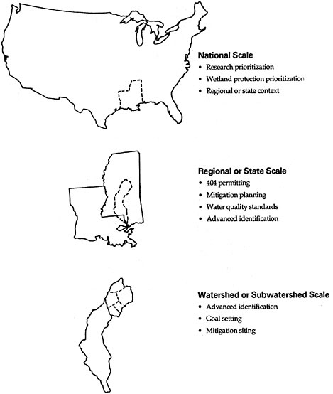
FIGURE 5-6 Applying synoptic assessments at various spatial scales. SOURCE: Lie bowitz et al. (1992).
identified and prioritized for funding. At subwatershed scales, priorities could be set for locating restoration projects along specific stream reaches that are in the greatest need of mitigation.
Functional Assessments
As discussed above, the assessment of riparian areas at the scale of individual sites can be done either with functional methods that estimate probabilities that a riparian function exists or with reference-based methods that estimate ecosystem condition. Two functional methods developed in large part for aquatic and wetland ecosystems are the widely used Wetland Evaluation Technique and the Habitat Evaluation Procedure. We discuss both briefly to provide historical context and to acknowledge that some states now using some variation of the Wetland Evaluation Technique may be inclined to adapt it to riparian areas.
Wetland Evaluation Technique
The Wetland Evaluation Technique (WET) is based on the premise that wetlands have an array of functions that can be classed in one of three major categories: hydrologic, water quality, and habitat. Within each of these categories, more specific functions can be identified. Hydrologic functions attributable to riverine wetlands (and, by inference, to riparian areas), for example, include floodwater storage, reduction and desynchronization of downstream flood peaks, and reduction of flow velocity; WET identifies 11 such functions. The method evaluates the probability that a function will occur as high, moderate, or low.
WET is notable for its complexity, its attention to scientific literature, and the degree to which it has been adopted and used. The method was developed for use by the Federal Highway Administration (Adamus, 1983). Although a number of other assessments were in existence at the time (reviewed by Larson and Mazzarese, 1994), federal agencies adopted WET as a non-mandatory regulatory tool. Many permit applications for wetland alterations are accompanied by an assessment of alternatives using WET.
In addition to determining the probability of functionality, WET also evaluates whether the function will be performed (e.g., whether there is a sediment source from land disturbance to be trapped) and the social significance (whether there are people who will benefit from the function). Because WET considers an much broader array of wetland functions than do individual assessors, projects evaluated with WET are subject to greater consistency and comprehensiveness than those evaluated by individual users, who have widely divergent backgrounds and perspectives.
Still, shortcomings of the method would likely remain should WET be modified for use in riparian areas. One of the limitations of WET is the assumption that all wetlands are capable (to some degree) of performing all of the listed functions.
Emphasis is placed on the level or degree of function, not necessarily on whether an unaltered site would normally perform the function at low, but sustainable, levels. As a result, most functional assessments assign high scores (e.g., probabilities of performing the function) to sites that have been modified to perform a certain function, regardless of whether the area would have done so in its unaltered form. If applied to riparian areas, this approach could lead to justification of enhancing specific functions, perhaps with unanticipated or undesired consequences. Extreme examples of enhancing specific functions might be to (1) build reservoirs to reduce downstream flood peaks, (2) convert riparian forest to emergent marsh to encourage waterfowl and wading birds, or (3) divert excessive sediments and other pollutants toward riparian areas to maximize their water-quality functions. In each case, some functions would be sacrificed for the enhancement of others, but the riparian area would depart even further from natural, self-sustaining conditions.
Habitat Evaluation Procedure
The Habitat Evaluation Procedure (HEP) was developed in the early 1970s to evaluate the habitats of aquatic and terrestrial species using certain variables (FWS, 1980). These variables are combined into Habitat Suitability Index (HSI) models constructed to evaluate an “element,” such as whitetail deer, wood duck, or hardwood cover type (for gray squirrel, piliated woodpecker, etc.). Once the HSI is determined, it can be multiplied by acreage to determine habitat units. The output from the procedure can be used to make recommendations on projects that would result in a change of HSIs. According to a review of the procedure in 1985 (Whitaker et al., 1985), there were 120 published and 75 draft HSI models.
The scaling of an HSI ranges between 0 and 1.0, with 1.0 representing “the condition…that is needed to support the highest numbers of wildlife species on a regional scale over a long time” (Schroeder et al., 1992). HEP focuses on conditions that are optimal for a species rather than using a reference system as a basis of comparison. The concept has been applied more recently to communities, such as bottomland hardwood forests, rather than species-specific habitats. One of the frequent comments about HSI models is that they are time-consuming in both development and application. Moreover, because the models were developed to predict habitat for species populations, application to riparian condition would require some extrapolation. Finally, the method uses literature reviews and best professional judgment, rather than reference sites, as the primary sources of information for model development.
Reference-based Assessments
The most powerful assessment methods are dependent, to some degree, on knowing the background or reference conditions within a region. Reference-
based assessment is premised on the assumption that sites unaltered by human activities represent the best benchmarks or standards for comparison. Some of their advantages are (1) everyone uses the same standard of comparison, thus reducing bias, (2) natural variation, rather than some fixed standard, is recognized as an intrinsic property of riparian areas, and (3) relative comparisons (larger, smaller, equal to) are much more repeatable and are faster to obtain than absolute estimates. Three rapid assessment techniques are presented and compared below: Proper Functioning Condition, which was developed explicitly for riparian areas, and the Hydrogeomorphic Approach and the Index of Biological Integrity, which can be adapted for use in riparian areas.
Proper Functioning Condition
The Bureau of Land Management (BLM), in cooperation with other agencies, developed the Proper Functioning Condition (PFC) assessment for riparian areas and wetlands in the American West, where it has been used widely. PFC refers both to the assessment method and to the condition of a riparian site. As a method, PFC qualitatively assesses how well certain site attributes, mainly physical processes, are working, relying heavily on expert judgment. The method is premised on the assumption that if appropriate physical conditions are restored to a site, the restoration of biological components will follow. PFC is also that condition which will support or allow a riparian area to reach its biological potential. In the late 1980s, BLM set as an agency goal the restoration and maintenance of 75 percent of riparian–wetland systems on BLM land to “proper functioning condition” by 1997 (Prichard et al., 1993, 1998).
Ideally, an interdisciplinary team of specialists in vegetation, soils, and hydrology and of biologists with expertise in fish and wildlife conduct a PFC assessment, filling out a checklist of questions about hydrology, vegetation, and erosion and deposition (as shown in Box 5-4). Sites are then placed into one of four categories (Prichard et al., 1998) described below.
Proper Functioning Condition: Riparian areas are functioning properly when vegetation, landform, and channel characteristics are adequate to dissipate stream energy associated with high water flows (i.e., 25- to 30-year events; Wayne Elmore, BLM, personal communication, 2000), thereby reducing erosion; filtering sediment, capturing bedload, and aiding floodplain development; improving flood-water retention and groundwater recharge; developing root masses that stabilize streambanks against cutting action; developing diverse ponding and channel characteristics to provide the habitat and the water depth, duration, and temperature necessary for fish production, waterfowl breeding, and other uses; and supporting greater biodiversity. The functioning condition of riparian–wetland areas is the result of interaction among geology, soil, water, and vegetation.
|
BOX 5-4 To evaluate a riparian site using PFC, an interdisciplinary group must answer “yes,” “no,” or “not applicable” to the following items. Asterisks refer to items that lack a “not applicable” choice. For any of the items marked as “no,” specific comments must be recorded and discussed by the assessment team. Hydrology
Vegetation
Erosion/Deposition
|
Functional-At-Risk: This category includes riparian–wetland areas that are in functioning condition, but existing soil, water, and/or vegetation attributes make them susceptible to degradation.
Nonfunctional: Riparian–wetland areas are nonfunctional when they clearly are not providing adequate vegetation, landform, or large wood to dissipate stream energy associated with high flows and thus are not reducing erosion, improving water quality, etc., as listed above. The absence of certain physical attributes,
such as a floodplain where one should be, is an indicator of nonfunctioning conditions.
Unknown: This category includes riparian–wetland areas for which BLM lacks sufficient information to make a determination of the functioning of the area.
If the alterations and stressors that make a site “nonfunctional” are corrected, it is assumed that the site will achieve a rating of “functional-at-risk” or higher as vegetation establishment and growth take place over time. The goal of riparian management is always to achieve proper functioning condition, “because any rating below this would not be sustainable” (Prichard et al., 1998). Twelve PFC publications supplement these basic instructions, addressing methods for measuring vegetation, the characterization of channels, recommendations for grazing practices, interpretation of aerial photography, and use of historical photographs, as well as providing a review of the literature (Prichard et al., 1998). Separate guides have been prepared for lentic areas (non-flowing waterbodies, or lakes and ponds). To improve the condition of sites, the guidebooks suggest that “best management practices need to be set in motion” although this is not a requirement of PFC.
The PFC method was developed principally for riparian areas in the 11 contiguous western states where the majority of BLM’s land occurs outside of Alaska. There is nothing about the approach that precludes its use in the eastern part of the United States, although a number of modifications would be necessary to tailor it for that region. For example, PFC is designed to assess physical conditions responsible for maintaining ecosystem structure. It has not been established how well the approach works in low-gradient, vegetation-dominated floodplains of humid climates where the biological components of riparian areas have strong feedback on fluvial geomorphology in terms of stabilizing bank erosion, reducing channel migration, and enhancing sedimentation. In addition, the method does not assess riparian areas along ephemeral streams (because of BLM’s definition of “riparian”), although it could be modified to do so.
BLM has established a training and development team with the primary responsibility for instructing local professionals on application of the method in an attempt to improve the effectiveness and efficiency of its application on BLM lands. Because of its relative simplicity and ease of use, PFC is an effective tool for communicating with landowners and others with nontechnical backgrounds. As a result, many stakeholder groups have a greater awareness of the importance of riparian restoration. Acceptance may not have been possible with a more rigorous, quantitative method (Wayne Elmore, BLM, personal communication, 2000). Because of the method’s popularity, there is an ongoing effort to enhance data sharing among the agencies using PFC, an effort spearheaded by the Information Center for the Environment at the University of California, Davis.
The method is implicitly a reference-based approach because it identifies the condition of a site relative to one that has a proper functioning condition rating.
However, unlike the Hydrogeomorphic Approach and the Index of Biological Integrity (described below), PFC relies on the judgment of a team of local experts rather than on a group of reference sites that captures the range of natural variation within a geographic region.
It should be noted that the PFC rating is not necessarily the same as the capability or the potential of a site. “Capability” is defined by BLM as the highest ecological status, given political, social, and economic constraints (e.g., presence of dams, ongoing watershed land use, etc.). “Potential” is defined as the highest ecological status without those constraints. These ratings are the result of quantitative data collected using BLM’s system for inventory and classification, called an Ecological Site Inventory (Leonard et al., 1992). Ecological Site Inventory is not a component of PFC assessment. Rather, Prichard et al. (1993) recommends that the Ecological Site Inventory document (and others) be reviewed.
Although PFC has been widely used by federal agencies in the West and provides immediate feedback to land managers, it nevertheless has several potential limitations. First, because it is qualitative, PFC is vulnerable to subjective application, which places a great burden on the consistency and skill of the local assessment teams. Consequently, it is difficult to compare assessments over several years to assess progress towards the anticipated condition. Second, emphasis is placed almost exclusively on hydrologic and geomorphic features rather than on biological or ecological functioning. Where vegetation is used (i.e., age class, species composition, plant vigor), it is more an indicator of hydrology and geomorphology than of biology. Virtually no direct attention is given to the terrestrial or wetland habitat functions of riparian areas. If the local assessment team is not familiar with sites in good ecological condition and their characteristic plant communities, its capability to assess the status of a stream is likely to be diminished. Finally, because only the site conditions on a PFC rating form are addressed, the spatial context and connectivity of a given riparian area relative to a watershed setting are not explicitly recognized. Thus, though the PFC approach is an efficient methodology for identifying nonfunctional or functional-at-risk riparian areas—an important issue for many riparian areas in the American West—it has limited capability for quantitatively characterizing the relative level or degree of ecological recovery of riparian areas that have attained a “proper functioning condition” rating.
Prichard et al. (1998) acknowledge that PFC is not a replacement for inventory or monitoring protocols designed for plants and animals dependent on riparian–wetland areas, nor is it a replacement for watershed analysis. However, PFC is a useful tool for prioritizing restoration activities that can reduce the frequency of data collection and labor-intensive inventories by concentrating efforts on the most significant problem areas. A number of the shortcomings discussed above could be addressed with a second-generation, up-to-date method. The approach could be strengthened and the assumptions better understood if studies were conducted to independently validate PFC results.
Hydrogeomorphic Approach
In the early 1990s, the U.S. Army Corps of Engineers’ (Corps) Waterways Experiment Station sought an alternative functional assessment method to WET, principally to use in the evaluation of impacts to wetlands, the analysis of alternative sites for development projects that alter or replace wetlands, and the design and evaluation of wetland mitigation projects. The hydrogeomorphic (HGM) approach, developed for this purpose, consists of three components: classification by geomorphic setting, development of a reference system as a benchmark of comparison, and identification and assessment of wetland functions (Smith et al., 1995). The HGM approach compares wetland condition relative to a group of sites that have been minimally impacted so that deflection from the natural variation can be estimated. Functions are used to estimate condition, in contrast to approaches that rely on biota alone. Some functions are based on structural characteristics of a wetland while others rely on species composition.
Seven generic wetland classes (riverine, depression, slope, lacustrine fringe, estuarine fringe, organic soil flats, and mineral soil flats) are used to guide local classifications, or subclasses. Classification is a critical component that allows standards to be developed for and applied to a relatively homogeneous group of wetlands within a biogeographic region (Brinson, 1993). For example, floodplains associated with some first- and second-order streams differ in species composition and hydrology from higher-order streams (Rheinhardt et al., 1999). The purpose of classification is to partition the natural variation among subclasses so that variation due to impacts can be more easily detected.
Measurements are made of structural and biotic variables that relate logically to one of three functional categories: hydrology, biogeochemistry, and habitat. For example, variables relating to nutrient cycling (biogeochemistry) include condition of the riparian buffer, whether or not the stream is channelized, the maturity of the floodplain forest, and the presence of detritus. The nutrient cycling function receives a score based on the status of these variables, each of which is indexed relative to unaltered sites. For example, a site with a channelized stream, a missing buffer, immature forest cover in the floodplain, and suboptimal amounts of detritus would receive a score of 0.4 (relative to 1.0) for the nutrient cycling function (Rheinhardt et al., 1999). Other functions are similarly assessed. Functional indices may be multiplied by surface area in order to compare two or more sites that differ in condition and size.
HGM relies on the development of a guidebook that contains a literature review, an identification of functions, data on variables from reference sites within the biogeographic region of interest, and “models” that relate variables to functions (Smith et al., 1995). Interdisciplinary expertise is incorporated into the development of guidebooks through workshops, field-testing, and peer review. Specific training to use the guidebooks, which helps ensure greater consistency in application, is recommended. This is in contrast to the PFC approach, which requires an interdisciplinary team conducting on-site assessments.
Reference sites are explicitly required in the HGM approach. Terms such as reference standards sites and site potential are provided to distinguish different benchmarks of comparison, recognizing, for example, that restoration of degraded riparian areas in urban landscapes can never achieve natural, unaltered conditions. Given that some recovery in such landscapes may be desirable, the term “site potential” provides an attainable endpoint.
In a typical assessment conducted to estimate the effects of an unavoidable impact, the project site is evaluated in its pre-project condition using the appropriate guidebook. Each variable that contributes to a function is compared to the standard derived from a range of variables at unaltered sites. The condition of the site is then predicted based on alterations expected from the project. Differences between functional indices before and after the project are calculated (upper half of Figure 5-7).
In addition to assessing impacts, the HGM approach was developed to estimate improvement in conditions resulting from restoration (lower half of Figure 5-7). Rather than predicting losses based on project impacts, the method estimates gains in condition resulting from restoration activities. The output of an assessment allows comparisons between changes in condition integrated over surface area. Thus, a restoration of a large but moderately degraded site could potentially compensate for a severe impact to a previously unaltered small site. The details of what is acceptable compensatory mitigation, however, are beyond the intent and capability of the HGM approach. It is important that a policy framework be established to provide guidance necessary for deciding how to interpret and use the results of the assessment.
The HGM method has been adapted for application to selected riparian areas (Hauer and Smith, 1998; Wissmar and Beschta, 1998), even though it was initially developed for evaluating the condition of riverine wetlands. Non-wetland portions of riparian areas are assessed by identifying the “flood-prone width” of a floodplain (Rosgen, 1995). At the time of this writing, only one guidebook for riparian areas has been published (Ainslie et al., 2000), although others are in various stages of development.
Strengths of the method include its use of a reference system, the short time required to conduct an assessment, and the consistency among assessors (Whigham et al., 1999). The reference system involves not only the sites representative of the natural and human-induced variations in a geographic region, but also the body of scientific literature applicable to the riparian or wetland type. Much more data are collected from reference sites than are incorporated in the final assessment tool; the final method used in the field is pared down to include only measurements that are sensitive to activities that alter or degrade the functioning of sites. This background work makes it possible to conduct simple assessments in a matter of hours.
HGM considers components of the flow regime such as the magnitude and frequency of discharge, the duration of specific flow conditions, the predictabil-
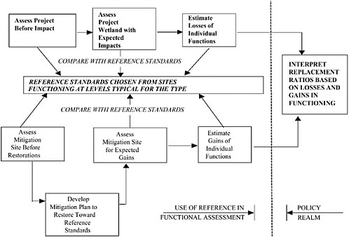
ity of high or low flows, and the rate at which flows change (Poff et al., 1997). Unlike other methods that focus almost entirely on flows within the channel (Peters et al., 1995), HGM can also account for the frequency of overbank flows and their effect on floodplain plant communities. In spite of its “hydrogeomorphic” name, the method takes into account species composition and structure of vegetation as well as functions dealing with animal habitat. Biological variables could be further analyzed using methods developed for biological integrity assessments (see below).
Guidebooks can be updated when new information becomes available. The approach is modular, so changing one portion of a guidebook does not necessarily require revisions in other parts. Assumptions are clearly stated, thus eliminating the “black box” syndrome of WET and PFC’s reliance on a team of specialists. An additional benefit of having reference sites is for training and education.
Difficulties surrounding the HGM approach include the lack of high-quality reference sites and the expense of developing the procedure for additional riparian subclasses. Especially in urbanizing areas, streams and their associated riparian areas may already be affected by tree removal, invasive species, gullying caused by changes in runoff patterns, and other alterations. In such generally degraded conditions, there may be a tendency to lower standards for restoration without acknowledging that higher-quality conditions once existed. The development of guidebooks requires a considerable amount of fieldwork and synthesis, an expense that could be considered prohibitive in some riparian management programs.
Indices of Biological Integrity
Biological integrity refers to the ability of a system to support and maintain “a balanced, integrated, adaptive community of organisms having a species composition, diversity, and functional organization comparable to the natural habitat of the region” (Karr and Dudley, 1981). Measures of biological integrity, such as species richness or trophic composition, are used to compare sample site characteristics to that of reference sites or conditions that are minimally influenced by human activities. For example, the Index of Biological Integrity (IBI) (Karr, 1981) explicitly uses reference conditions to ensure that the best available conditions are used as a benchmark for comparison. During the past 20 years, managers have applied a number of biologically based approaches to measure the effects of water pollution and landscape alteration on water quality (Lenat, 1993). These methods principally use aquatic invertebrates or fish communities as the basis for evaluation.
A primary argument for developing these approaches was that reliance on chemical analysis of water failed to account for many of the habitat conditions that are essential to the biological integrity of an aquatic ecosystem (Karr, 1991;
Karr and Chu, 1999). Biota are also viewed as the ultimate integrators of environmental conditions (Karr, 1991).
Although other indices of biological integrity have been developed (see Box 5-5), IBI is the most frequently used and thus is the focus of this section. IBI attempts to integrate the condition of the entire watershed above the point of sampling in a stream, although the actual IBI score reflects a mixture of watershed and site-specific influences (see Roth et al., 1996). A common application of IBI is to compare aquatic insect larvae and other arthropods from streambeds (benthic IBIs) above and below a point source of pollution. In many states, an IBI based on fish is a routine part of water-quality monitoring of streams and provides substantial information for Clean Water Act 305(b) reports. The approach is responsive to larger-scale influences of urbanization, grazing, and agriculture as well as recreation (Karr and Chu, 1999).
Two approaches for analyzing IBI data have been developed: the multimetric procedure (Karr, 1981) and the predictive model method (Hawkins et al., 2000).
|
BOX 5-5 A technique that shares some attributes of biological integrity assessment is the Floristic Quality Assessment Index (FQAI). This index, developed independently of the approaches described above, is based on the method developed for the Chicago region by Wilhelm and Ladd (1988). It was designed to assess the degree of “naturalness” of an area based on the presence of ecologically conservative species. It is thought to reflect the degree of human-caused disturbance to an area by accounting for the presence of non-native and cosmopolitan native species. This index is capable of measuring ecosystem condition because it assigns a repeatable and quantitative value to the plant community. To calculate the FQAI, a complete species list must be compiled for the site. Each species on the list is then assigned a rating (tolerance values) between 0 and 10 (Andreas and Lichvar, 1995). A rating of 0 is given to opportunistic native invaders and nonnative species. Tolerance values of 1–10 are assigned as follows: values of 1–3 are applied to taxa that are widespread and do not indicate a particular community; values of 4–6 are applied to species that are typical of a successional phase of some native community; values of 7 and 8 are applied to taxa that are typical of stable or “near climax” conditions; and values of 9 and 10 are applied to taxa that exhibit high degrees of fidelity to a narrow set of ecological parameters. The scores are summed to produce an overall score for the community. Presumably, this approach could be applied to riparian areas with some modification. However, as presently constructed, FQAI is measuring the extent to which a site can support a specialized plant community rather than comparing a site to reference conditions based on minimal human influence. The highest scores, for example, identify unique or rare floristic communities rather than identifying a broader range of community types that are distinguished mainly by having received minimal human influence. |
Figure 5-8 shows how the multimetric approach compares the distribution of six invertebrate numeric values for a degraded site and one that is relatively unaltered. The circles represent the position of the attribute (a measurable component of the biological system such as taxa richness) for the unaltered site (E. Fort Cow Creek), and the triangles show the location of the same attributes for the degraded site (Lower Elk Creek), ranging from the relatively unaltered on the right to highly degraded on the left. Attributes are chosen such that they will change (preferably linearly) in value along a gradient of human influence. They should reflect changes in the site from best to highly altered conditions. Thus, taxa are restricted to species compositions sensitive to pollution, but attributes may also include the presence of fish with physical abnormalities. Metrics of 5, 3, and 1 shown at the top of the diagram are assigned to several known relationships between aquatic taxa and environmental conditions. Indices that compile the metrics for several attributes can then be used to rank streams according to their condition. In Figure 5-8, the six metrics shown were combined with five others to yield multimetric scores shown as the benthic IBI. By using these two sites and others that span the range of conditions, criteria can be developed to classify sites as excellent, good, fair, poor, or some other scale that has both biological and regulatory significance. IBIs have also been determined for various metrics such as species richness along a gradient of stream order (Karr and Chu, 1997).
The predictive model approach differs from the multimetric only in the way that data are analyzed, not in the biological components chosen. Predictive models calculate the sum of individual probabilities of finding all taxa of interest relative to a reference site. In addition to sampling the same groups of organisms, additional environmental information (e.g., latitude, elevation, channel slope, alkalinity, etc.) that is likely to be independent of human activity is collected. As a result, it is claimed that predictive models are more effective in regions where streams encounter steep gradients in elevation, temperature, and other factors (Hawkins et al., 2000).
Although IBI was developed for measuring benthic populations in streams, theoretically any biological integrity index can be adapted to riparian areas in one of two ways. One is based on the assumption that riparian area condition and upstream land uses are reflected in a typical analysis of benthic invertebrates or fish. This may be particularly effective in rangelands where grazing by domestic cattle is a principal influence. However, the method may not be able, by itself, to discriminate grazing effects in uplands from the activities of cattle within riparian areas or in the streambed. It should be noted that many riparian areas lack sufficient surface water, seasonally, to use biological assessments based on aquatic macroinvertebrates and fish. Furthermore, the characterization of benthic populations is often an expensive and time-consuming task; thus, results are seldom known immediately. The other approach is to develop metrics for the vegetation and biota of the non-aquatic portion of riparian areas. The specific community of biotic indicators may include soil invertebrates, amphibians, birds, or vegetation.
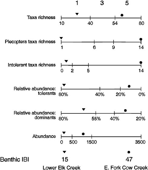
FIGURE 5-8 Benthic IBI scores derived from metrics of invertebrates at a degraded site (Lower Elk Creek) and a relatively unaltered site (E. Fork Cow Creek). Intolerant taxa richness would be the number of species that are sensitive to degradation of water quality in the broadest sense. SOURCES: Reprinted, with permission, from Karr and Chu (1999). © 1999 by Island Press. Reprinted, with permission from Fore et al. (1996). © 1996 by Journal of North American Benthological Society.
In late 1999, EPA led an effort to develop the methodology for biological indicators in wetlands—an approach that should be transferable to riparian areas if appropriate reference conditions and sites are identified.
Vegetation-based biological assessments may be more reliable for riparian areas than animal-based ones because the more persistent vascular plants integrate conditions over longer time periods. Indeed, for wetlands (and presumably for riparian areas) the approach consists of developing biotic indices for an assemblage of wetland plants and combining these with other biological indicators (metrics) into a composite index. Whoever develops and implements the assessments must be skilled in identifying the chosen group of organisms.
Comparison of Methods
The three reference-based assessment methods described above are compared in Table 5-1. All are oriented toward evaluating the condition of ecosystems (or portions of them) by comparing a test or project site with conditions expected in the absence of human activities or in least-disturbed sites. They all use classification as a means of partitioning variation between that due to natural sources (i.e., different wetland classes or different stream orders) and that due to human activities that have degraded the system. Once methods are developed in the form of indices (in the case of biological integrity) or guidebooks (for the HGM approach), their application is relatively rapid, requiring several hours to days depending on the complexity of the assessment. PFC is the most rapid in that the scorecard is filled out in the field and the results are “immediately” known.
PFC does not require a database and thus is highly qualitative and dependent on the knowledge base and judgment of the assessment team. The other two methods are based on data gathered and analyzed for both unaltered and degraded sites, and they use quantitative data to establish the level of variables (for HGM) or indices (for biological assessment) prior to assessor involvement. The collection and analysis of such data require considerable expertise.
For conducting assessments, training is also necessary, but in different ways and to different degrees. For HGM assessments, a science background is expected, and training is oriented toward consistent use of the guidebook. In some cases, taxonomic expertise is required, but usually for a relatively small group of taxa. Field measurements of forest stand structure, percent cover of vegetation, presence of non-native species, types and extent of hydrologic alterations, soil characteristics, and surrounding land uses are typical types of data required for an HGM assessment. For biological integrity assessments, a greater degree of expertise is required for specific taxonomic groups of plants, animals, or both. As in all assessments, experience is a valuable asset in assuring consistency and accuracy. In the PFC approach, the importance of experience and consistency is paramount because of the lack of quantitative information for guidance.
From a practical standpoint, reference-based methods are more easily developed in some areas than others. In landscapes that are highly altered, unaltered reference sites are rare or completely absent. This may require the use of historical records or sites that are geographically separated from the area of interest. In many eastern states, land ownership has fragmented the landscape and made it difficult to gain access to sites for collecting data upon which to build assessment methods. Unlike many western areas where federal ownership is common and access is relatively easy, more populated areas pose significant barriers to access for data collection.
A major impediment to reference-based assessments is the development of standards and metrics for a sufficient number of riparian classes. Both methods that require reference data were developed primarily for wetlands rather than for riparian areas. This is not seen as a barrier because the underlying principles and, to a great extent, the methodologies, would be the same, especially for riparian areas that also contain wetlands. Biological integrity approaches have been in existence about 15 years longer than HGM. Consequently, biological integrity methods have been extensively tested, synthesis volumes have been written on the topic, and a large cadre of technicians has been trained to identify aquatic invertebrates and fishes. This training may not be relevant in riparian systems that lack corresponding aquatic taxa and would have to be developed for the taxa found in riparian areas.
The biological integrity and HGM approaches are not mutually exclusive. In the HGM guidebooks prepared for wetlands, important components are species composition of vegetation, the presence of non-native species, and groups of indicator species sensitive to alteration. For biological integrity methods developed for wetlands, metrics can be developed for hydrophytic plants, much like the Floristic Quality Assessment Index described in Box 5-5. In highly modified landscapes where relatively unaltered conditions are absent and cannot be effectively reconstructed from historical sources, managers are using biological integrity approaches based on an array of plant species that span the range of tolerances to alteration (Lopez and Fennessy, 2002). In either case, methods are directly transferable to riparian areas, especially to riparian classes that are dominated by wetlands.
No single approach will fill all the possible needs for assessing riparian condition. Fortunately, there exist several methods and approaches to choose from to meet the specific needs of restoration, ranging from landscape-level to site-specific, from rapid and qualitative to research-level and model-based, and from those designed to answer ecological questions to those oriented toward socioeconomic issues. However, two features of routine, rapid assessments are essential: (1) availability of information at a scale as large as or larger than the management unit and (2) the availability of reference sites. In spite of the development of these rapid methods, there will always be a need for comprehensive, research-based approaches to generate new ideas and to validate indicators used in the rapid approaches.
TABLE 5-1 Comparison of Environmental Assessment Methods that Are Either Used in Riparian–Wetland–Aquatic Areas or Could Be Modified for These Areas
|
Attributes |
Proper Functioning Condition |
|
Primary purpose for developing |
Restore and maintain riparian–wetland systems on BLM lands |
|
Primarily applied to which systems |
Riparian–wetland ecosystems on BLM lands, mostly in the arid West |
|
Use of reference |
Reference is embedded in the professional judgment of the multidisciplinary team |
|
Use of classification to partition natural variation |
No explicit approach to classification is provided; assessment team is responsible for recognizing regional conditions for reference |
|
Use of indicators |
|
|
Hydrologic |
Physical factors are central to evaluating condition |
|
Geomorphic setting and related attributes |
Physical factors are central to evaluating condition |
|
Plant and animal species composition |
Species composition of vegetation partly indicates whether physical factors are effective |
|
Physical plant community structure |
Vigor and type (shrub, herbaceous) of vegetation indicates whether physical factors are supportive of “proper functioning condition” |
|
Level of effort to develop |
Training of regional teams has been conducted; work is continuing |
|
Level of effort to conduct assessment |
Requires a multidisciplinary team of experts to visit sites |
|
Expertise of assessor |
Several qualified individuals from different disciplines (vegetation, soils, hydrology, fish/wildlife) |
|
Potential challenges in modifying for riparian areas |
None; was developed specifically for riparian areas and wetlands, but lacks validation |
|
Hydrogeomorphic Approach |
Indices of Biological Integrity |
|
Assess impact and provide compensatory mitigation in the Clean Water Act Section 404 program |
Provide a biological method to assess overall condition of ecosystem quality |
|
Developed for wetlands, but encompasses associated riparian areas in arid riverine environments |
Developed initially for streams to assess watershed condition; recently being modified for wetlands |
|
Must be developed as the basis for conducting assessments; least-altered sites are the benchmark, but altered sites are needed for scaling condition |
Uses lack of human activity for reference. Scores estimate departure of altered sites. The range of conditions is used to categorize indices as high, medium, or low. |
|
Classification is fundamental to developing relatively homogeneous standards for comparison |
For wetlands, uses the HGM classification approach |
|
|
|
|
Highly dependent on identifying water sources and flows necessary for evaluating functions |
Seldom used; instead, biotic indicators are central to method |
|
Essential both for classification and evaluating condition |
Not required except for the classification step |
|
Plants, especially, used to indicate alteration; non-native species can be used to indicate degraded conditions |
Biological data are central to the assessment, especially aquatic animals; vegetation indicators are undergoing development |
|
Essential for evaluating condition |
Not required |
|
Substantial effort required for field data collection, establishing reference standards, and developing guidebook |
Substantial effort required for field sample collection, analysis, and development of multimetrics and predictive models |
|
Requires office preparation (maps, photos, etc.), field visit to collect data, and simple arithmetic computations |
Requires field collection and processing of samples |
|
Science background. Although the approach is simplified for the non-specialist, training is required to improve consistency among users |
Taxonomic expertise needed for relevant biota (e.g., aquatic macroinvertebrates, fish, native and alien plant species, etc.) |
|
Some; already encompasses flood-prone width for streams; needs little modification for riparian areas that contain wetlands |
Need to adapt biological assessments to terrestrial areas |
|
Attributes |
Proper Functioning Condition |
|
Major strengths |
Tailored specifically to arid riparian sites; easy for nonprofessionals to understand; a multidisciplinary team of experts must be present at the site |
|
Major weaknesses |
Relies on best professional judgment of assessors to establish reference conditions; ignores habitat values |
|
Situations to which the procedure applies |
Western riparian situations where a group of specialists can determine whether mostly physical conditions are available to sustain, improve, or further degrade a riparian area |
Policy Considerations
None of the approaches described in the preceding section addresses policy interpretations of the results (Kusler and Niering, 1998). Although providing such an analysis would go beyond the scope of this report, it is important to understand the limitations of these assessments when their results are turned over to decision-makers. First, there is a substantial need for policy to bridge the gap between outputs from science-based assessments to management decisions affecting riparian resources. As with the choice of assessment methods for riparian conditions, the policy framework should be scaled to the types of questions being asked. For example, reference-based assessments tend to assign low scores to urban riparian areas in degraded conditions. From this standpoint, one could argue that less overall loss occurs when urban riparian areas are converted to other uses than when rural ones are converted. This could lead, in the absence of a policy framework, to less protection of rare but highly visible urban riparian areas compared to rural areas. In general, concepts of rarity, uniqueness, location (with respect to human uses), and educational value are not taken into account by site-specific assessments of condition. Screening methods such as Hydrogeologic Equivalence and the Synoptic Approach may identify these attributes, if they are calibrated to do so.
There are assessment methods that fall between the science-based assessments described above and the policy realm. “Multicriteria” methods provide ways to optimize environmental management decisions that go beyond assessment of ecological condition. These tend to be project-by-project approaches for siting landfills, highways, etc., and are not specific to riparian areas; Europeans are leaders in this area (Voogd, 1983; Janssen, 1994). Multicriteria approaches
|
Hydrogeomorphic Approach |
Indices of Biological Integrity |
|
Allows detailed restoration planning because of information from the reference system; a simple assessment is rapid |
The basic IBI approach has been around for 20 years, allowing many of the problems to be resolved; background literature is available |
|
Has a high front-end cost for developing regional guidebooks |
Has been incompletely developed in wetlands where vegetation is the principal biotic variable |
|
Once a reference system is developed for a riparian class, assessment determines current condition of a site, and can project losses or gains due to alterations or restorations, respectively |
Once multimetric or predictive models are developed for a riparian class, assessment places the site within a continuum of alteration by human activities |
address the need for making decisions that are supported by the public. To better integrate public participation in decision-making on riparian resources, education is required about the condition of riparian areas and implications for social well-being (i.e., “quality of life,” internalizing environmental costs, etc.). Unless riparian areas are broadly recognized as contributing to social well-being and policies are put in place to maintain their functions, it is unlikely that decision-makers will have either the tools or the political will to effectively maintain and enhance the functions and values of riparian areas.
Finally, there are many impediments to integrating ecological research into economic development. Foremost are the reluctance of ecologists to recognize that global economies drive environmental decision-making and the conflicting assumptions that exist between ecology and economics (Di Castri, 2000)1. The application of integrated approaches to riparian areas is particularly complicated because streams often cross geopolitical and ownership boundaries and interface with vastly distinct land uses. Nonetheless, some of the progress made in valuing wetlands is applicable to riparian areas. For example, scale and landscape setting are attributes that influence the value of both wetlands and riparian areas. Other ideas gleaned from wetlands that might be applicable to riparian areas are that (1) values to individual stakeholders change depending on proximity to the resource, (2) as wetlands become rarer, they become more valuable at the same time that they undergo progressive degradation from human activity, and (3) from strictly economic perspectives, more valuable ecosystems should replace less valuable ones (Mitsch and Gosselink, 2000). Beyond that, assigning monetary values to
ecological services of riparian areas can never fully account for true value, and should not be the principal or sole approach to biodiversity and ecosystem services (Gatto and de Leo, 2000). Nevertheless, the assignment of production functions2 to environmental services of ecosystems can contribute information that may lead to better decisions on the largest net benefits to society (Acharya, 2000). None of the assessment tools described above bridges these science– policy gaps, but they may provide information for economic analyses.
Conclusions and Recommendations
Currently, there are no nationally recognized protocols for assessing the ecological condition of riparian areas. A range of approaches is needed to satisfy assessments at scales ranging from watersheds to individual sites, and from rapid assessment to research-driven analyses and model building. Because riparian areas are the main connectors of landscapes at watershed scales, assessments should begin with large-scale analyses that evaluate the variety, location, and connectivity of riparian areas. Landscape-scale methods that utilize widely available data are useful in determining large-scale restoration needs, protection strategies, and goals for other forms of management. Site-specific assessments have undergone considerable evolution and development over the past 20 years. There are opportunities to tailor many existing wetlands assessment methods to riparian areas.
Tools for riparian management range from assessment approaches that rely on simplistic measures to full watershed analysis, research, and modeling of ecosystem structure and function. Rapid assessments are useful as screening tools to help make decisions where immediate action is necessary, while a more robust science-based approach is required to establish longer-term management actions (including reference-based monitoring and adaptive evaluation of the effectiveness of restoration activities). In either case, the full range of stakeholders must be included in the process to determine desired riparian condition (e.g., ecological restoration), based upon unambiguous articulation of available knowledge of riparian structure and function.
The concepts underlying most assessment tools currently used for wetlands and aquatic ecosystems are transferable to riparian areas, suggesting that these tools can be modified to assess the condition of riparian areas. In
some cases, this would require an expansion from the aquatic portion to the floodplain and terrestrial parts of riparian areas. In cases where wetlands are major components of the riparian areas, modifications would be minimal. The extent of riparian area must first be identified so that assessment includes riparian areas that are highly degraded and not easy to recognize.
Proper Functioning Condition, the only method developed specifically for riparian areas, provides a good first-generation framework for riparian assessment. This method can be rapidly applied and may have its greatest utility in quickly identifying riparian areas that have been significantly degraded (i.e., nonfunctional and functional-at-risk). However, there is currently no assessment of biological components because the assessment is built principally by evaluating physical factors. The current version should be refined to increase its capacity to link physical conditions with water quality, instream biota, plant community structure and composition, and terrestrial animal communities. The approach should become more quantitative and rely more on regional reference sites rather than on the exclusive judgment of a team of local experts. Information on reference sites, a component that is currently lacking, would contribute to validation of the method.
The Hydrogeomorphic Approach holds considerable potential for assessing the condition of riparian areas. HGM is a reference-based system, originally developed for wetlands, that provides data useful not only for the assessment of condition, but also for the overall design of regional or watershed-scale restoration efforts. The current HGM methodology should be revised, as needed, for direct use in riparian areas across various geographic regions. This will require the development of guidebooks specifically for ecological restoration of riparian areas.
Biological integrity assessments, which have not yet been used in riparian areas, should be evaluated for their ability to encompass riparian community types. Until recently, most biological assessments have been limited to aquatic ecosystems. However, biological assessment of aquatic systems and riparian plant communities, for example, can be used independently or as a component of the hydrogeomorphic approach. Such assessments are needed to independently validate the biological portion of HGM assessments.
All the methods described above should be expanded to include more types of riparian areas, tested by users, and independently validated with appropriate research. Independent testing and evaluation is a critical need of all assessment methods. This is important to ensure their accuracy, usability, and, perhaps most importantly, their credibility for use across the diverse suite of riparian areas that occur in any given region.
Regardless of the science-based tools used to assess riparian condition, the output from these evaluations must be implemented through policies that take into account both environmental and socioeconomic issues. Decision-makers are usually faced with a number of competing values, of which goods and services derived from riparian areas are only one of many. Unless the output from riparian assessment tools can be placed into this broader context, there is little likelihood that the resulting information will be helpful. Consequently, users of the information should be determined before the assessments are interpreted.
MANAGEMENT STRATEGIES
This section discusses management strategies for restoring the hydrologic regime, geomorphic structure, and vegetation characteristic of riparian areas. Although the scientific basis for restoring riparian areas has rapidly expanded in the last couple of decades, the implementation of restoration practices is in its infancy. In addition, there is much to be learned socially and institutionally about opportunities and limitations for improving these important systems. Nonetheless, some generalities can be made about the appropriateness and effectiveness of certain management strategies. Perhaps most important is that the range of possible restoration activities is broad, from simple activities at a single site to large-scale projects. In many cases, relatively easy things can be done to improve the condition of riparian areas, such as planting vegetation, removing small flood-control structures, or reducing or removing a stressor such as grazing or forestry. Where the objective of restoration is to improve the entire river system, more holistic watershed approaches will be necessary, and management strategies such as removing impediments (e.g., large dams) to the natural hydrologic regime may be required. There are few examples of these larger-scale activities having been conducted with the expressed purpose of restoring riparian areas.
The discussion of management approaches that follows is not meant to be exhaustive, but rather illustrative of how significant ecological improvement of riparian systems might be attained. Some of these strategies will be more passive, some more active, and others a blend of both passive and active approaches. In all examples, successful restoration appears to be based on extensive local knowledge of hydrology and ecology including the range of natural variability, disturbance regimes, soils and landforms, and vegetation; on understanding the history of resource development; and on identifying reference sites. Because restoration is not a deterministic process for which the outcome can necessarily be predicted with high temporal or spatial resolution, it might appropriately be considered a journey involving riparian systems and societal goals, with both evolving over time.
Reestablishing Hydrologic Regime and Geomorphic Structure
Previous chapters have discussed how hydrologic disturbances and sediment dynamics play important roles in maintaining the function of riparian areas. Dams constructed to control floods or generate hydropower, locks, low-water diversion channels, and off-stream storage ponds have precipitated fundamental changes in the flow regimes and the geomorphic character and sediment dynamics of rivers. Many water resources developments have caused concurrent degradation in water quality and fish and wildlife habitats as well as dwindling amounts of riparian areas along lake shores, streambanks, and floodplains. In the opinion of this committee, repairing the hydrology of the system is the most important element of riparian restoration. If the flow regime—in terms of magnitude, frequency, timing of peak flows, and other features—is not sufficient to meet the needs of the ecosystem, riparian restoration will ultimately fail (see Poff et al., 1997).
It is important for both stream and riparian restoration for managers to understand the limitations of structural changes in the absence of flow regime changes. For example, typical channel restoration projects meant to improve the complexity of instream fish habitat often involve the addition to channels of gravel or structures with the objective of reversing degradation. However, these projects often fail to consider the importance of hydrologic disturbance, such as the need for peak flows to flush fine sediment from gravels for continued spawning success of salmon (Lisle, 1989; Kondolf and Wolman, 1993). Geomorphic restoration alone cannot bring about the complexity that would result from a fully functioning river corridor with free-flowing exchange of sediment and wood between the channel and riparian area.
Another example is the attempt to increase instream habitat complexity by adding anchored structures on the banks or beds of channels. Even when the added materials are natural in character, anchored structures do not allow the types of adjustments that occur in a system that naturally changes shape in response to floods. Expensive reengineering of a meandering channel with large wood fixed in place has a high probability of substantial reworking during subsequent periods of high flow. Long-term restoration of instream habitat is unlikely to be achieved without full consideration of the flow disturbances on the dynamics of such structures.
Historically, restoration involving changes in flow regime such as dam reregulation has usually targeted fish populations and has not considered riparian objectives. The fact that few hydrologic regimes have been restored expressly for riparian purposes reveals the relative newness of this concept. In addition, most of the available examples of dam reregulation are found on larger rivers, perhaps because there has been greater social and political impetus to makes changes in these systems. For larger rivers, reregulation of dam operations may be one of the only restoration options available because of the limitations imposed by perma-
nent structural modifications. Nonetheless, recreating a more natural hydrologic regime is fundamental to the ecological restoration of rivers of all sizes.
This section discusses how long-term restoration of riparian areas might be achieved if components of the natural hydrologic regime, sediment dynamics, and hydrologic connectivity between rivers and their floodplains were reestablished. Restoring more natural flooding regimes and sediment dynamics in the nation’s rivers is likely to be a major theme for environmental science in the twenty-first century (Poff et al., 1997).
Operation, Modification, or Removal of Dams
The vast majority of dams and reservoirs in the United States were completed well before concerns about riparian areas became widely evident. As a result, reservoir release patterns often have done little to support functioning of downstream riparian systems (e.g., Rood and Mahoney, 1990). Although the mandated purposes of a particular dam (e.g., irrigation withdrawals, hydropower generation, flood control) may legally constrain its management, opportunities usually exist to change the storage and release of water to help maintain floodplains and related riparian areas. Restoring the natural flow regime should focus on reestablishing the magnitude, frequency, and duration of peak flows needed to reconnect and periodically reconfigure channel and floodplain habitats (Stanford et al., 1996). In addition, baseflows should be stabilized to revitalize food webs in shallow-water habitats. Another important goal is to reconstitute seasonal temperature patterns (e.g., by construction of depth-selective withdrawal systems on storage dams). These mitigative actions do not reconstitute pristine, pre-alteration conditions but rather normative conditions. Such normative conditions can have measurable benefits to specific attributes such as fish habitat or riparian vegetation if sustained by careful, science-based management of reservoir storage and releases (Stanford et al., 1996).
As increasing numbers of privately owned hydroelectric dams in the United States undergo relicensing by the Federal Energy Regulatory Commission (FERC), regulators should consider modifying flow-release policies to help avoid or mitigate adverse impacts to downstream riparian areas (i.e., to create normative habitat conditions). The Corps and the U.S. Bureau of Reclamation (USBR), in continuing a policy shift toward providing multipurpose benefits in addition to their traditional focus on flood control and irrigation (Whittaker et al., 1993), should consider the maintenance of downstream riparian systems when setting operational policy for federal dams. Box 5-6 considers some of the recent trends in federal dam operations, including the Yakima River in Washington where dam reregulation is being implemented at the watershed scale.
Changes to dam operations have most commonly been motivated by the flow needs of downstream fisheries. In the Pacific Northwest, the proposed removal of the Elwha and Glines Canyon Dams along the northern portion of Olympic
National Park and of four major Snake River dams has been a major topic of discussion because of their detrimental impacts to native salmon runs. A recently completed restoration activity involved removing a dam on the Kennebec River in Maine for fisheries purposes. The Edwards Dam, built on the Kennebec River in 1837 to facilitate upstream navigation and to generate hydropower for sawmills, was removed in 1999 after a protracted legal battle. The actions are expected to restore seven species of migratory fish to the Kennebec River, a goal that required removal of the dam because at least four of the affected fish species were not known to utilize fish ladders of any kind.
Many fewer cases of dam re-regulation involve riparian objectives. Fortunately, research is now demonstrating the essential functions performed by periodic flooding in shaping river channels, building floodplains, creating backwater sloughs, and supporting riparian vegetation; as a result, dam operations are changing in some locations to allow at least some controlled flooding. Prescribed flooding has the potential to become a management tool similar to the use of prescribed burns in managing forests and grasslands. Given the current level of water resources infrastructure, dammed rivers will probably never have flow releases that fully replicate pre-dam flow regimes, and upstream portions of dammed rivers may never be restored. However, in many areas there may be major opportunities for altering flow release patterns so that they are increasingly “friendly” to the hydrologic needs of downstream riparian areas.
An example is the operation of the Corps’ dam on the Bill Williams River, which originates in the highlands of western Arizona and flows generally west to its junction with the Colorado River at Lake Havasu. In 1968, the Corps completed construction of Alamo Dam on the Bill Williams River 39 miles upstream from the Colorado. Operation of the dam—primarily for flood control—sharply reduced peak flows, increased flows in some periods, and completely cut off flows in others. Studies in the early 1990s documented the degradation of the riparian habitat along the Bill Williams and attributed that degradation to the change of flow regime resulting from operation of Alamo Dam. In 1996, Congress specifically directed the Corps to modify operation of Alamo Dam. The resulting feasibility report recommended “pulse” releases in the spring and fall, combined with a flooding “event” at least once every 5–10 years, together with base flows varying from 10 to 50 cubic feet per second (USACE, 1998). The Corps based its recommendation on studies demonstrating the effectiveness of different surface and groundwater regimes for supporting native riparian vegetation (Shafroth et al., 1998, 2000).
The cottonwood reestablishment on the Rio Grande from 1993 to 2001 is another example of where simulated flooding has led to the regeneration of riparian vegetation (Crawford et al., 1996; M. C. Molles, University of New Mexico, personal communication, 2001). Other studies have tried to determine the portion of the hydrograph that is essential for driving lateral channel migration and successional changes in riparian vegetation, suggesting that a water
|
BOX 5-6 Operating regimes for federally managed water-storage facilities are determined in the first instance by the purposes for which the facilities were authorized for construction and operation. Older facilities tend to be single-purpose, such as for irrigation water, navigation, or flood control. Beginning in the 1930s, federal facilities typically were authorized to serve multiple purposes, and by the 1950s, fish and wildlife generally were included as one of the purposes. Many federal water facilities—particularly those constructed to provide irrigation water—operate in accordance with water rights obtained from states and from contractual agreements with project beneficiaries who, in return, repay a portion of the cost of constructing and operating the facilities. Water rights, based on beneficial uses, establish the manner and amount of project water storage. Contracts govern the manner and amount of water releases to serve these beneficial uses. In the Flood Control Act of 1970, Congress authorized the Corps to evaluate modifying its operation of existing facilities when it determined doing so was in the public interest. The 1986 Water Resources Development Act provided the Corps authority (in Section 1135) to undertake environmental enhancements associated with existing projects, including restoration of ecological resources and processes of affected hydrologic regimes. USBR does not have general authority of the kind possessed by the Corps to alter project operations based on environmental considerations. Nevertheless, USBR has modified operations of many projects—as directed by project-specific congressional enactments, to comply with its obligations under federal environmental law (particularly the Endangered Species Act), or to better serve authorized project purposes. For example, in the 1994 Yakima River Basin Water Enhancement Act, Congress directed USBR to operate the federal Yakima Project so as to provide “target” minimum flows at two key diversion points to facilitate movement |
storage and use regime that does not interfere with this portion of the hydrograph could be compatible with riparian ecology (Richter and Richter, 2000). In the northern Great Plains, it has become increasingly recognized that high flows in May and June, when cottonwood seed release commonly occurs, are important for successful cottonwood regeneration (e.g., Rood et al., 1999). These flows not only create mineral seedbeds by their scouring action and deposition of sediment, but as the flows recede they also allow the downward root growth of germinated cottonwood seedlings to track falling water tables. If high flows are curtailed too abruptly, root growth cannot keep up with falling water levels, and establishment will not succeed. Thus, establishing a flow regime downstream of reservoirs that mimics some of the high-flow dynamics of the original river system could serve as a major restoration tool and is important for successfully maintaining gallery forests associated with these river systems. Similarly, experimental high-flow
|
of salmon (MacDonnell, 1996). The Yakima River in central Washington is a tributary of the Columbia River that historically had robust salmon and steelhead runs. Development of the river basin as a major agricultural production area required extensive regulation of flows to provide irrigation. Regulation of the river, coupled with over-harvest, vastly depleted the anadromous stocks and only remnant populations remain. The USBR-run irrigation system currently depletes average flood peaks, but water storage is insufficient to substantially retard major floods and therefore a fair amount of channel–riparian complexity remains. However, the base flows are substantially altered and some reaches below the major diversion canals are nearly dry during late summer. Moreover, construction of an interstate highway in the riparian corridor of the river coupled with urban and agricultural expansion onto the floodplains has mediated extensive gravel mining and channel revetment. In 1992, the USBR was charged to determine biologically based flows that would allow restoration of the fisheries. It focused on purchase of water rights for instream flows, water conservation through installation of modern irrigation systems, land acquisition to allow flooding of riparian areas, and research to demonstrate relations between flows, riparian succession, and fish habitat for key floodplain reaches of the river system. The restoration plans call for removal of revetments to naturally restore floodplain function. The project is a good example of an ongoing whole-basin riparian restoration project that has coupled basic research with clear management objectives and stakeholder participation. Implementation of restoration activities, such as acquisition of floodplain land and available water rights from willing sellers, has gone on simultaneously with research that attempts to determine the normative flow regime for the river. The project involves private landowners, the Yakima Indian Nation, federal and state lands and management entities, and university researchers. Normative flows in this river system are expected to be implemented within the next few years and a monitoring plan for evaluating success of the project is in place. For more information see www.umt.edu/biology/flbs. |
releases from Flaming Gorge Reservoir on the Green River in Wyoming have been evaluated not only for their benefits for endangered species of fish, but also for their effects on downstream riparian areas and their vegetation (Andrews, 1986; Merritt and Cooper, 2000). As discussed in Box 5-7, releases of water from Stampede Reservoir to the Truckee River in the 1990s in support of the spawning needs of an endangered fish have been associated with cottonwood regeneration along riparian lands in the lower portion of the river. Other prominent examples have occurred on the Upper Colorado River and the Napa River.
Recent decisions regarding the management of dams on the upper Missouri River reflect changing attitudes toward incorporating environmental considerations into dam operations (NRC, 2002). In November 2000, the U.S. Fish and Wildlife Service (FWS) released a biological opinion for the revised management of six dams on the Missouri River in eastern Montana and the Dakotas. The
|
BOX 5-7 (Sources: Rood and Gourley, 1996; Gourley, 1997) For most of the 1900s, the Truckee River from Lake Tahoe in California to Pyramid Lake in Nevada has been heavily regulated. Starting in 1902, dams along the 140-mile length were constructed for irrigation, domestic, and industrial purposes, with the result that roughly half of the flow from the lower Truckee River was diverted. In addition to the flow changes, the Corps widened and deepened the river from Lake Tahoe to about 3,200 feet downstream to protect the city of Reno from floodwaters. These modifications made the river channel more susceptible to erosive forces, as evidenced by damage to the channel and riparian area following floods in 1963 and 1986. Prior to 1902, the Truckee River and Lake Tahoe had been home to the Lahontan cutthroat trout, while the lower Truckee and Pyramid Lake supported large populations of cui-ui. Because of alterations to the streamflow that curtailed spawning runs, the native Lahontan cutthroat became extinct in the 1940s; the cui-ui is now close to extinction (and is a federally listed endangered species). Other cutthroat populations have been reintroduced into the system and are now listed as “threatened” under the Endangered Species Act. During the same period (first half of twentieth century), cottonwood-dominated forests in the riparian areas along the river declined to a fraction of their historic extent. To help stimulate spawning and the eventual recovery of the cui-ui, the FWS began managing the Stampede Reservoir in the 1970s by changing release flows and creating artificial fish passages. The flow modifications consisted primarily of increasing outflow from the reservoir from April to June. By 1992, the adult cui-ui population had rebounded significantly from its low point, with over 1 million fish counted. The success of the recovery was also attributed to several very wet years that complemented the flow modifications. The change in management coincidentally produced conditions favorable for cottonwood germination and sapling survival. Prior to the flow changes, the river level was so low during summer months that cottonwood recruitment was negligible. In years during which outflow from Stampede was increased, and in several naturally wet years, cottonwood recruitment peaked. Survival was found to correlate not only with flow levels, but also with a slow rate of decline in river levels over time—confirming that the timing, frequency, and duration of flow are all important factors in the lifecycle of riparian vegetation. Parallel with the recovery of cottonwoods, songbird populations have also returned along the Lower Truckee. The FWS has promoted future management of the river’s dams to support both fish populations and cottonwood recruitment. |
opinion calls for operation of the dams to create higher spring flows and lower summer flows compared with flows under past management. The purpose of increased spring flows is to provide reproductive cues for the federally endangered palled sturgeon and other species, and to build sandbars that would be used by nesting terns and plovers during the time of exposure of the bars in summer.
Lower summer flows would also provide shallow water for young fish. Although not explicitly discussed, this proposed change in management might improve cottonwood recruitment in riparian areas. The plan also calls for adaptive management with monitoring, which would allow dam operations to be adjusted in the future as new information becomes available about changing environmental conditions. FWS’s opinion about dam management on the upper Missouri would increase slightly the risk of flooding during spring and have some negative impacts on recreational navigation at low flow; it is hoped that these impacts would be offset by positive effects on fishing, canoeing, and camping. The Corps will make its final decision regarding the biological opinion at the conclusion of the national environmental policy process for the Missouri River master manual.
Complications for River Sediment Dynamics. Manipulating sediment dynamics is not usually a principal restoration activity. However, one consequence of river restoration projects may be changes in the sediment transport regimes that could affect interactions between channels and riparian areas. This is especially true when restoring a river’s natural flow regime by manipulating dam operations to create variable flows or by removing dams altogether. Either strategy could change rates of sediment transport and deposition in ways that affect the size, morphology, and disturbance frequency of sediment patches that are suitable for establishment of riparian plants (Friedman et al., 1996; Scott et al., 1996).
An example of a river restoration project that affected sediment dynamics was the controlled flood in the Grand Canyon in 1996. In this case, the principal goal was redistributing sediment from the channel to build exposed, sandy platforms such as point bars (locally called “beaches”) that are valued as riparian habitat and as campsites for river rafters (Schmidt et al., 1999). Researchers are still debating how floods should be controlled in order to rebuild and maintain beaches and to keep the beaches free of tree seedlings and saplings. However, the effectiveness of controlled floods in building beaches is strongly related to upstream sediment sources in the river (Topping et al., 2000); these sources were significantly reduced by the construction of Glen Canyon Dam. It may be difficult or impossible to maintain beaches over the long term in such sedimentstarved systems.
Sediment dynamics is a major issue for the proposed restoration of the Ventura River within the Los Padres National Forest, CA. The Matilija Dam was built in 1947 for flood control and irrigation water supply. The dam blocked steelhead from much of their upriver habitat. The Ventura River steelhead, which is genetically distinct from populations further north in California, was listed as an endangered species in August 1997. Sedimentation behind Matilija Dam has vastly reduced its flood-control capacity; an estimated 6–11 million cubic yards of clay and silt are located behind the dam. Whether the sediment could be released to the channel below the dam in a staged deconstruction, or whether the
sediment would have to be disposed of elsewhere, is one of the major uncertainties associated with any proposal for dam removal. A preliminary analysis by the Bureau of Reclamation suggested that the cost of removal could be as much as $180 million depending on the plan for sediment disposal.
Another California dam, Engelbright Dam on the Yuba River, also poses significant sediment problems. The dam has trapped tailings from hydraulic mining, which are likely to contain significant quantities of toxic metals. Any plans that would involve the release of trapped sediments to the downstream river would have to address the fate of those contaminants. Some important variables that could affect the redistribution of contaminants include (1) association of contaminants with the different grain sizes and differential transport of those grain size fractions, (2) interactions between the reestablished flow regime and the newly released sediment, and (3) relative importance of downstream sediment fluxes versus lateral (between channel and floodplain) sediment fluxes. These factors will determine how the morphology of the channel and the surrounding floodplain changes, the extent to which contaminants are redistributed between them, and the time period that contaminants are likely to be stored in new deposits.
Modification or Removal of Levees and Other Flow Containment Structures
There is considerable potential for restoring riparian areas by altering levees, dikes, and other structures designed to impede the movement of water away from a channel. Where new levees are proposed to reduce or prevent flooding of streamside areas, setting them back some distance from the edge of a river or stream would at least ensure the maintenance of near-channel riparian areas. For areas where levees are already in place, gaps in existing levees could be created that would allow inundation of former floodplains and reestablishment of riparian vegetation. If undertaken in conjunction with setback levees, such an approach would continue to protect specific lands or structural developments from flooding at high flows while allowing overbank flows on some portions of former floodplains. Although such an approach is physically feasible, the costs of creating gaps, the economic effects of flooding former floodplains, and the costs of constructing additional setback levees might preclude the implementation of this approach in many areas. However, where the ecological and social values associated with reestablishing periodic flooding (e.g., increased detention storage of flood waters, increased riparian functions, improved habitat and food web support for aquatic organisms and wildlife) are high and the economic costs are low, breaching or creating gaps in levees and dikes may be a relatively straightforward approach to reclaiming significant amounts of historical riparian area. Complete removal of existing levees or replacement with levees further from the river can be expensive, often necessitating not only the movement of fill, but also substantial changes in existing land uses.
In order to promote successful restoration in “high-intensity use” riparian areas, compromises in the planning process are likely, as illustrated by the restoration of the Napa River riparian area in north-central California. The City of Napa’s Living River Plan was developed by a coalition of the Corps, state and local governments, resource agencies, businesses, and environmental organizations in response to a problem created by overdevelopment in the river corridor. The area has experienced 27 floods since the 1850s, causing over $540 million in damages since 1960. Initial plans by the Corps called for deepening the river channel, raising the levees, lining levees with concrete, and frequent dredging. In contrast, the Living River Plan includes terraced marshes and broad wetlands in place of the levees, which were moved farther from the river channel. Rather than deepening the river channel, the river corridor was widened by hydrologically reconnecting it with much of its former floodplain; this required removing from the river’s banks 16 houses, 25 mobile homes, eight commercial buildings, and 13 warehouses. The $190 million needed for the project came from Congress and a sales tax in Napa County. In winning the support of a majority of county residents, the coalition successfully argued that if the floodplain restoration reduced flood losses, it would save about $20 million a year, even after considering project maintenance costs.
In urban and residential areas, where buildings, parking lots, and other structures fall into disuse, financial incentives and other resources could be used to assist landowners in removing physical features from near-stream environments. If such policies were adopted at regional or national scales, over time many riparian systems would improve as individual structures were removed and replaced by riparian vegetation.
Many streams and rivers in the United States are crossed by city, county, state, and/or federal highway bridges. Although these bridges are typically designed for passing high flows in a relatively unhindered fashion, the highway fills and embankments leading up to many bridges effectively prevent high flows from accessing historical floodplains and they hydrologically disconnect old channels. When these roadways and bridges are scheduled for updating, reconstruction, or other improvements, reconnecting former floodplains and side channels should be considered and implemented wherever possible.
Streambank Stabilization
Bank stabilization, utilizing a variety of structural approaches, has been undertaken along many streams and rivers throughout the United States. In general, these approaches have been implemented to prevent or retard streambank erosion—often with little recognition of the contributing causes. Even when the causes are known (e.g., increased runoff or unstable watershed conditions caused by loss of streambank vegetation due to harvesting of trees, grazing, or conversion to agricultural crops), a structural approach to stabilization has often been
implemented. Streambank stabilization is often relatively easy to design and inexpensive, and it provides relatively immediate relief to local landowners. However, it often precludes the slow and incremental channel adjustments that normally occur in streams. For example, natural flow variation causes streambanks to experience locally alternating periods of erosion and deposition. On the outside of meander bends, a stream may slowly erode the bank only to deposit other sediments on the interior bank (point bar). This natural evolution of fluvial systems and the riparian plant communities they support is truncated when streambanks are structurally stabilized.
Although it is unlikely that many streambank stabilization projects in heavily developed areas are likely to be dismantled in order to improve riparian functions, there is a real need to “soften” the impact of these structures. Particularly important would be their modification to allow and encourage the establishment of native riparian plants. To what extent this can be accomplished by plantings, by adding soil into the large pore spaces associated with many rock structures, by partial removal of a structure and replacement with soil that can support riparian vegetation, or by other approaches is largely unknown. Assessing the potential and practicality of revegetating structural streambank stabilization projects represents a pressing research need. Only recently has there been a systematic assessment of the hydraulic effects of riparian vegetation and an evaluation of flow-resistance equations for vegetated channels and floodplains (Fischenich, 1997; Syndi et al., 1998).
Discouraging Development in Floodplains and Meandering Streams
Chapter 2 defined meander belts as broad swaths of land surrounding sinuous channels that incrementally shift to reflect changing hydrologic, sedimentary, or riparian conditions (see Figure 2-3). Chapter 3 discussed how a variety of activities, including levee construction and urban development, can disrupt and sever the hydrologic linkages across meander belts in a variety of ways, impacting the spatial extent and sustainability of many floodplain riparian areas. Bank stabilization projects and other structural alterations in active floodplains also tend to curtail the natural dynamics, large-wood recruitment, and other riparian functions common to meander belts.
Where the general morphology of a meandering stream or river system remains intact—i.e., it is not significantly altered by human development or land uses—prevention of structural alterations that impact how the river and its riparian areas function is fundamental to ensuring the sustainability of these important systems. For example, 100-year floodplains could serve as an initial screening process regarding proposed development projects: developments proposed within the boundaries of the 100-year floodplain would be subject to a higher degree of scrutiny than similar projects outside the 100-year floodplain. In addition, should such a project go forward, a significant effort at mitigating its potential effects
upon riparian and aquatic systems would be required. Structures located relatively close to a stream or river should be more closely evaluated regarding their potential to affect river and riparian processes; whenever possible, structural features and developments (including vegetation removal) should be located farther from rather than closer to the river.
A complex example of restoring the hydrologic regime to a river and riparian area is the reengineering of Florida’s Kissimmee River (see Box 5-8). The Kissimmee River was once a broad meandering river and was intimately connected with its floodplain. However, in the 1960s the river was channelized, with attendant effects on wetlands, other fish and wildlife habitats, and water quality. The goals of the restoration effort are to recapture many of these ecological and social values. Unlike many other water resources restoration efforts, the restoration plan utilizes multiple strategies to alter the hydrologic regime, including dechannelization, changes in water release, and removal of several canals and water-control structures.
Conclusions and Recommendations on Hydrologic Regime and Geomorphic Structure
Strategies that focus on returning the hydrologic regime to a more natural state have the greatest potential for restoring riparian functioning. Riparian vegetation has evolved with and adapted to the patterns of changing flows associated with stream and river environments. Furthermore, floodplain structure and functioning are dependent upon periodic inundation. Thus, changing dam operations, removing levees, and otherwise re-creating a more natural flow regime and associated sediment dynamics is of fundamental importance for recovering riparian vegetation and the functions that it provides.
Unless changes are made to return the hydrologic regime to a more natural state, other geomorphic and structural restoration activities are likely to fail. The temporal dynamics of the flow regime are fundamental to the structure of riparian plant communities and the functions they perform. Thus, simply attempting geomorphic or structural modifications is unlikely to meet ecological restoration goals.
Dam operations should be modified where possible to help restore downstream riparian areas. Compared to restoring stream flows for fisheries purposes, in very few cases have riparian objectives been the goal of dam re-regulation. There is an increasing need to send greater flows down long segments of rivers to improve riparian plant communities; specific riparian objectives could involve the amount of vegetation recovered and vegetation structure. The effects on downstream riparian areas of manipulating dam discharges should be moni-
|
BOX 5-8 Sources: Dahm et al. (1995), Toth et al. (1998), Warne et al. (2000) The Kissimmee River in south central Florida connects several major lake systems by meandering across a broad floodplain called the Kissimmee Valley. Between 1962 and 1971, the central channel of the Kissimmee River was deepened to 30 feet and compartmentalized into a series of five relatively stagnant pools by flood-control structures. As part of the Central and Southern Florida Flood Control Project, the channelization of the Kissimmee had the main purpose to provide an outlet for floodwaters from the upper basin. The project had substantial unanticipated effects, including the loss of 30,000–35,000 acres of wetlands, a reduction in wading bird and waterfowl usage, and a continuing long-term decline in game fish populations. These impacts spawned numerous state and federally mandated scientific studies that culminated in an overall restoration plan that was authorized as a state–federal partnership in the 1992 Water Resources Development Act. Restoration of the Kissimmee floodplain mainly involves filling 22 out of 56 miles of flood-control canal and removing two of the five water-control structures. Dechannelization will restore the wider, slower flow-way and increase hydrologic exchange with the adjacent floodplain. Another aspect of restoration is a change in the regulation of water releases from upstream lakes, which will reestablish continuous inflows and allow a more natural seasonal pattern of high and low flows in the river. Some concerns were raised about the restoration project’s impact on water supply and navigation. Although restoration of the river’s floodplain wetlands is likely to result in greater evapotranspiration losses of water during wet periods, the project is not thought to be likely to affect regional water supply, even during droughts. During extremely dry periods, navigation potential may be impeded through some sections of the restored river; however, it is expected that navigable depths of three feet or more will be maintained at least 90 percent of the time. |
tored to help identify those practices that show potential for aiding riparian restoration. In few cases will it be possible to reinstate pre-dam conditions, but it may be possible to create a smaller, more natural stream that mimics many characteristics of the historical one. Impediments to changing dam operations include both legal and socioeconomic factors.
Future structural development on floodplains should occur as far away from streams, rivers, and other waterbodies as possible to help reduce its impacts on riparian areas, and existing human uses of floodplains should be modified where possible to allow periodic flooding of riparian areas. Structural developments typically have significant and persistent effects on the size, character, and function of many riparian areas. Thus, preventing unnecessary structural development in near-stream areas should be a high priority at local,
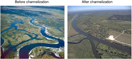
regional, and national levels. In addition, acquisition of land through conservation easements can be used to retain currently undeveloped land within floodplains in a more natural state. Communities and municipalities can, for example, use the area between a river and its 100-year floodplain boundary to delineate those areas where significant structural development would not be allowed and where existing structures might be removed when opportunities avail themselves.
Vegetation Management
Because of the fundamental importance of vegetation to the ecological functioning of riparian areas, where such vegetation has been degraded or removed, its recovery is a necessary part of any restoration effort. In many instances, recovery of riparian vegetation can be attained simply by discontinuing those
land- or water-use practices that caused degradation. For a variety of reasons, however, eliminating these practices can be a major challenge. Decision-makers and landowners often want to continue the resource use or physical alteration that led to the decline of riparian areas in the first place. But attempts to actively restore altered systems without reversing the cause of decline are not likely to achieve functional riparian vegetation.
The power of passive restoration for achieving functioning riparian vegetation cannot be overstated. Throughout many portions of the United States, streamside forests have been harvested for timber production, causing a multitude of effects (see Chapter 3). On these lands, riparian forests may recover if future tree harvesting is simply excluded from riparian areas. This approach assumes that native riparian plants remained as part of the post-harvest vegetation composition and were not replaced by a single forest species or by exotic species. Some functions will recover rapidly, while others may take considerable time. For example, the reestablishment of forest cover along a small stream might be accomplished within a decade or less, yet significant natural recruitment of large wood may be unlikely for 50–100 years or longer (see Figure 5-2).
With regard to historically harvested riparian forests, there may be opportunities to combine passive and active restoration approaches. The protection of riparian vegetation from future harvest would be a passive approach. Active restoration approaches include planting native trees to encourage the more rapid development of late-successional stages through intermediate harvests and augmenting large wood in streams to meet other ecological goals. In all these situations, the long-term goal would be establishment of a self-sustaining riparian forest.
For overgrazed riparian areas, the passive restoration approach is simply to exclude domestic livestock from riparian areas via fencing, herd management, or other approaches. Grazing strategies that alter the traditional season of use, stocking levels, or duration of use may allow recovery in some instances, but careful herd management is usually required on a year-to-year basis. Although grazing strategies other than full exclusion may promote restoration, they are likely to proceed more slowly and run a greater risk of failure.
In riparian areas that support agricultural crops, the reestablishment of native vegetation requires that cropping practices be altered or curtailed. Once this has been accomplished, natural revegetation may occur sufficiently rapidly that additional efforts at replanting may not be needed. In other instances, the reintroduction of specific plants may be needed. In many agricultural areas, the long-term loss of native plants and the widespread occurrence of exotic plants increase the difficulty of accomplishing restoration goals.
Factors such as water availability, flow duration, flood disturbance, channel and floodplain geomorphic change, soil chemistry, fire disturbance, and competition with exotic species directly influence the regeneration of particular species or communities and must be taken into account during restoration. This section
focuses on several broad areas of restoration—management of forested riparian buffers, reintroduction of large wood into streams, creation and maintenance of riparian buffers for water quality and habitat protection in agricultural areas, and grazing management.
Forestry in Riparian Areas
The management of forested riparian areas and its impacts on water quality and near-stream habitats have been an increasingly important issue over the last two decades, both in the Pacific Northwest (Salo and Cundy, 1987; Meehan, 1991; Murphy, 1995; Spence et al., 1996) and in other portions of the nation (e.g., Williams et al., 1997; Verry et al., 2000). In 1993, a multiagency task force (FEMAT) issued Forest Ecosystem Management: An Ecological, Economic, and Social Assessment, which summarized the scientific underpinnings for the Northwest Forest Plan and significantly changed how riparian areas on federal forest lands in the Northwest and elsewhere in the nation would be managed (FEMAT, 1993). The report highlighted the many roles of riparian areas, noting that the capability of a riparian area to provide a particular function depends on the distance from a waterbody (i.e., the width of the riparian buffer). For example, as shown in Figure 5-9, the effect of a riparian forest upon root strength (and its associated role in maintaining streambank integrity and channel stability) is greatest relatively close to the edge of a channel. In contrast, riparian forests provide large wood and shade to aquatic ecosystems potentially out to one site potential tree height from the channel, although most of the influence typically occurs within half a tree height (McDade et al., 1990; Murphy, 1995). Figure 5-9 also illustrates that where forested riparian buffers are of sufficient width to provide high levels of large wood and shade protection, functions related to bank stability and litter inputs are also generally satisfied.
FEMAT (1993) indicated that riparian areas were an important component of a four-part aquatic conservation strategy aimed at restoring and maintaining the ecological health of watersheds within the national forests of the Pacific Northwest. These components consisted of riparian reserves, key watershed protection, watershed analysis, and watershed restoration. Site-potential tree heights and slope distances were used as the “ecologically appropriate metrics with which to establish riparian reserve widths.” For watersheds with high drainage densities, the proportion of a given watershed that fell within the riparian reserve designation could be relatively high (e.g., in excess of 50 percent). The widths of riparian reserves identified in FEMAT (1993) were considered an interim strategy and it was expected that they would be changed upon completion of watershed analyses. However, these dimensions have become widely accepted within USFS and BLM as the widths of no-harvest riparian areas and were incorporated into the Northwest Forest Plan (see Box 4-4).
Because forested riparian areas often comprise a diversity of plant communi-
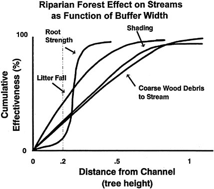
FIGURE 5-9 Generalized relationships indicating percentage of riparian ecological processes and functions occurring within indicated distances from the channel. SOURCE: FEMAT (1993).
ties and provide for a variety of ecosystem processes, functions, and values, it could be argued that specific forest management options are not necessarily well suited for meeting broad ecological goals. Thus, a passive approach to management (no-harvest) may be warranted where broad ecological goals have a high priority and where restoration or sustainability of functioning riparian systems via a no-harvest approach is likely to succeed. However, as indicated by Palik et al. (2000), the designation of riparian reserves or other riparian management areas as no-harvest buffers may preclude other management options and opportunities. These include not only the management of riparian forests for specific species and commercial timber products, but also the enhancement or active restoration of riparian functions. Active restoration may be particularly needed on industrial forestlands and land under other nonfederal ownership where previous management actions have greatly altered the composition and structure of native riparian forests. In such areas, even though a no-harvest option might recover desired ecological functions, the time required may be many decades or longer. (The recruitment of large wood from a previously harvested riparian forest may not occur for many decades; to grow large trees simply requires time.)
A no-harvest option would preclude silvicultural prescriptions that reduce the amount of time needed to develop a late-successional riparian forest, e.g., thinning from below. Similarly excluded would be forest operations that might be used to increase the amount of large wood recruited to a stream via the use of techniques such as directional felling (Garland, 1987).
Given that riparian areas function as ecotones between upland and aquatic ecosystems, Palik et al. (2000) suggests that the degree of harvest or other silvicultural treatments in managed riparian areas should vary with distance from a stream where the protection of aquatic resources is a high priority. According to this paradigm, the initial step for integrating functional objectives into silvicultural practice is to delineate the ecological boundaries of a riparian management area. The second step is to prescribe site-specific silvicultural practices that protect or enhance riparian functions along the riparian ecotone while meeting other management objectives; this prescription would outline the silvicultural system designed for the management area as well as a method for monitoring results over time. “A major purpose of the prescription is to insure that all activities are complementary and based on current knowledge and technology. In other words, the practice of silviculture in riparian forests should anticipate the future and prevent problems rather than respond to problems as they develop” (Palik et al., 2000). A final consideration in developing silvicultural prescriptions is to minimize the cumulative effects of individual activities. Figure 5-10 indicates some types of harvest options that might be considered depending upon ecological and landowner goals.
Once a decision is made to harvest trees within a riparian area, a number of operational considerations can have a major influence on the potential impacts, or lack thereof, associated with timber removal (Garland, 1987; Mattson et al., 2000). For example, ground-based felling, bunching, and yarding systems have the greatest potential for site disturbance and associated degradation of riparian resources, yet they are commonly used in many riparian areas because of their productive and economic advantages over other yarding methods. Thus, selection and use of ground-based logging equipment with specific features, such as wide or dual tires, flexible tracks, or double-axel bogie wheel assemblies, are important for minimizing impacts to soils, to residual vegetation, and to aquatic and riparian habitats and for maintaining riparian functions. Other opportunities for reducing potential onsite impacts might include undertaking yarding operations when soils are dry or frozen and establishing a designated skid trail system (Adams, 1983; Garland, 1983). The directional felling of harvest trees away from a body of water and pulling winch line into the riparian area can reduce or minimize many of the potential adverse effects of ground-based skidding. Where cable yarding systems are used, directional felling away from the stream, intermediate supports, and the use of skyline corridors may reduce or minimize many potential impacts. In other instances, the use of helicopters may be an environmentally sensitive and economically efficient means of yarding trees from ripar-
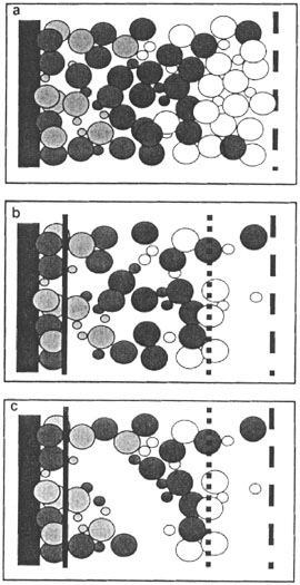
FIGURE 5-10 A riparian forest showing differing harvest patterns. The dark band to the left is a stream or other body of water. (A) The uncut forest showing the riparian management area within the functional ecotone boundary (dashed line on right). (B) The riparian forest is harvested along a gradient. Most of the trees are removed on the right, fewer numbers are removed in the middle such that the residual basal area is dispersed by cutting many small gaps, and an uncut forest remains nearest the stream. (C) Trees are harvested as in (B) except that the residual basal area in the middle part of the riparian area is clumped to open a single large gap. In both (B) and (C), mature stand structure and riparian functions are less impacted by harvest nearest the stream. SOURCE: Reprinted, with permission, Palik et al. (2000). © 2000 by CRC Press, LLC via Copyright Clearance Center.
ian systems. Regardless of which operational approach is taken to remove timber from a riparian area, recognition of the ecological functions and values of these areas should be incorporated into forest practice decisions.
In addition to the riparian areas in national, state, or commercial forest ownership, there are many miles of forested riparian areas (particularly in the eastern United States) that are not managed from a forestry perspective. Many of these riparian systems have experienced significant alteration over time, not only because of the impacts described in Chapter 3 but also simply because landowners may have removed trees for firewood, fence posts, or commercial sale or for aesthetic reasons. Such gallery forests, in various states of disrepair, are in need of the management philosophy embraced in the preceding discussion. The development of management prescriptions that will successfully reestablish various ecological functions over a wide variety of stream and forest types, and which are accepted from both practical and social perspectives, represents an important challenge for individual landowners and the nation.
Conclusion on Forestry
The use of buffer strips is important for maintaining and restoring both aquatic and riparian habitats associated with forest ecosystems. Along with the management of upslope forest practices, functional riparian buffers represent a major component of attaining clean water goals and must be designed to incorporate a strong ecological basis that adequately addresses short- and long-term goals. The dimensions (i.e., width) of riparian buffers and their application throughout a drainage basin (e.g., on intermittent streams, non fish-bearing perennial streams, fish-bearing perennial streams) are likely to vary depending upon ownership and management goals.
Introducing Large Wood
The role of large wood in aquatic ecosystems was first recognized in the early 1970s; thus, management of wood has been a relatively recent subject in riparian ecology and management. Nevertheless, research results have been adopted by many river and forest managers concerned with the protection and restoration of biodiversity, fisheries productivity, and nature conservation. Wood is now deliberately placed in stream channels, and active management of streamside forests is encouraged to supply large wood to the river network. Such practices are particularly popular in the Pacific Northwest, where restoration of stream habitats and riparian areas has sometimes exclusively focused on restoration of large wood. In some cases, management agencies have considered the geomorphic and hydrologic factors that determine appropriate locations, sizes, and amounts of wood before actions were taken. In other cases, agencies have rushed to reintroduce large wood without consideration of restoring the riparian forest
over the long term. Wood has also been widely added to streams across the Pacific Northwest that never contained appreciable amounts historically (e.g., meadows). Furthermore, concerns over liability for damage resulting from introduced wood have led many agencies to cable wood in place rather than promote the natural redistribution of wood and channel formation. As a result, assessing the success of restoring large wood has focused on whether the wood remains where it was installed. A more ecologically meaningful standard for success would be to determine whether wood is functioning in the stream system to create the habitat conditions and ecological processes identified as the goal of the restoration effort.
Because most of the pioneering research on large wood has been conducted in certain geographic regions, questions exist about transferring results across differing ecoregions of North America. Models of wood dynamics in streams have been developed over the last decade, with several more comprehensive models of stand dynamics, input, decomposition, and transport being developed currently. Such models offer a broad conceptual framework for transferring results of research on wood dynamics to different regions and forest types.
A final consideration that must accompany the use of wood as a management tool is the societal perception of this strategy. Floods transport and bring into streams large amounts of wood, which can pose threats to bridges and roads. Accumulation of wood in recreational rivers can create problems for boating and concerns about safety. Thus, large wood has traditionally been removed from stream systems, not reintroduced. Especially on private lands, it will be difficult to convince landowners, who are not aware of the ecological role of large wood, that its benefits outweigh the potential damage to, for example, their farming operations. The challenges are equally great for federal and state agencies that must balance multiple objectives, such as restoring biodiversity and reducing the costs of floods. In all situations, the best decision-making will require that large wood be viewed as an agent of restoration and not just as an impediment to flow and a source of damage during floods. As discussed later, programs that both educate the public and help identify locally acceptable compromises (that attain community objectives but alter the dynamics of large wood and riparian areas to the least extent possible) will be important to overcoming these perceptions.
Conclusion on Large Wood
Introducing large wood into streams draining forested watersheds can be an important short-term practice for assisting the recovery of instream habitats, particularly where large wood has been depleted by historical land uses and the remaining riparian forests are unable to provide sufficient large wood for many decades. Even in such situations, the restoration of riparian forests to provide for long-term large wood recruitment must remain a high priority. Where there is no historical or ecological basis for the introduction of
large wood (e.g., meadow and prairie systems dominated by graminoids and non-tree woody species), this management practice may cause further degradation to channels and riparian areas.
Buffers for Water-Quality Protection in Agricultural Areas
Buffer zones,1 both within and upslope from riparian areas, are currently being promoted as management measures for water quality protection throughout the world, particularly in the United States and Europe. As discussed in Chapter 4, major riparian buffer initiatives in the United States include the federal Conservation Buffer Initiative and state and regional restoration programs such as the Conservation Reserve Enhancement Program (CREP) and the Chesapeake Bay Riparian Forest Buffer Initiative. Many of the state CREP programs focus exclusively on riparian area restoration. For example, the CREP goals in Virginia and Maryland are to restore 12,300 and 40,500 hectares (30,500 and 100,000 acres) of riparian habitat, respectively. The 1996 Chesapeake Bay Riparian Forest Buffer Initiative, an agreement between the District of Columbia, Maryland, Pennsylvania, Virginia, and the EPA, seeks to restore 2,010 miles of forested riparian buffers within the Chesapeake Bay watershed by 2010. These are but a few of the hundreds of federal, regional, state, and local buffer programs that are currently restoring riparian areas across the United States.
There are a number of reasons why these programs are so widespread and popular, particularly in agricultural areas. Many of these programs are voluntary, and some compensate landowners and farmers for buffer establishment and maintenance. They generally focus on a narrow band of land along streams, and thus do not affect a large portion of the agriculturally productive landscape. (In many cases, these lands are marginally productive and landowners can make more money enrolling them in buffer programs, while in other instances taking them out of production may not be cost effective.) Furthermore, if properly installed and maintained, buffers can have a high capacity to remove nonpoint source pollutants from upslope activities—as much as 50 percent of the nutrients and pesticides in surface water runoff, 60 percent of certain pathogens, and 75 percent of the sediment load (NRCS, 2000a). Consequently, one might view riparian buffers as a panacea for nonpoint source pollution problems, particularly in agricultural areas, deducing that improved management of upland areas is not necessary for water-quality protection. However, this is not the belief of most conservation professionals, who suggest and/or require that buffers be used as part of a larger conservation management system. This section summarizes the current state of knowledge concerning the effectiveness of buffers for water-quality protection and suggests approaches that can be used to improve their effectiveness.
Buffer Design. Buffer zones are typically used as best management practices (BMPs) along lower-order streams for enhancement of water quality, protection of fish and wildlife habitat, and possibly production of timber/biomass. To meet such diverse objectives, riparian zones must remove sediment from overland flow, remove and sequester nutrients and other pollutants from overland and shallow subsurface flows, and provide habitat values in the form of streamside shading, generation of coarse and fine particulate matter, and food and cover for wildlife.
Three principal types of buffers are being promoted in the United States for water quality protection: grassed filter strips, the multi-species riparian buffer system, and the three-zone riparian forest buffer. Grassed filter strips are the simplest type of buffer, defined by the NRCS as a strip of herbaceous vegetation situated between cropland, grazing land, or disturbed land (including forest land) and environmentally sensitive areas. Their stated purpose is to reduce sediment and adsorbed and dissolved contaminates in hillslope runoff and to restore, create or enhance herbaceous habitat for wildlife. The filter strip consists of permanent herbaceous vegetation consisting of a single species or a mixture of grasses, legumes and/or forbs adapted to site conditions. The minimum width required for a grassed filter strip is 20 feet (USDA-NRCS, 1999a), but much wider strips—50 to 150 ft—are generally required for participation in the federal CRP and CREP programs (USDA-NRCS, 2000b).
The multi-species riparian buffer system (MSRBS) was developed in the Midwest and is particularly adapted to the American prairie region where trees may not have been a major component of natural riparian areas (Schultz et al., 1995; Iowa State University, 1997). As discussed in detail in Box 5-9, the MSRBS consists of three zones: the first zone of trees to increase bank stability and to produce high value timber, the second zone of shrubs to provide diversity to the ecosystem and help slow flood water, and the third a strip of native warm-season grasses next to the cropland for pollutant removal functions. The MSRBS is flexible in that the tree zone can be replaced by shrubs and/or both the tree and shrub zones can be replaced by grasses. Elimination of the tree zone and expansion of the grass and shrub zones is fairly common in intensively channelized and tile-drained watersheds in the Midwest, partly because some land owners object to trees along the stream that may lead to channel blockage (Schultz et al., 2000). However, the combination of trees, shrubs and grasses helps protect stream quality more than a single species buffer (Iowa State University, 1997).
In the humid eastern portion of the United States, a three-zone riparian forest buffer approach is being promoted to satisfy water quality and limited habitat values in agricultural areas (Lowrance et al., 1985; Inamdar, 1991; Welsh, 1991; Schultz et al., 2000). As described below and in Box 5-10, each of the subzones has specific functional roles. Depending on the management objectives at a site, not all three zones may be required, or the width of less critical zones may be greatly reduced. According to the NRCS, the minimum width for a riparian forest
buffer is 100 ft or 30 percent of the floodplain width, whichever is less. However, state CREP and CRP programs may have different (usually wider) requirements.
The runoff control zone is located at the upland edge of the riparian zone and has many functions. Because it is composed of densely growing herbaceous vegetation, usually grass, it offers high resistance to shallow overland flow and reduces runoff velocity and sediment transport capacity. It also reduces runoff volume and transport of dissolved pollutants because its vegetative cover promotes infiltration.
This zone should be designed and maintained so that it converts entering concentrated flow into sheet flow in order to improve the effectiveness of the adjacent managed forest zone in trapping pollutants (Dillaha et al., 1989). Under shallow, sheet flow conditions, the runoff control zone will account for most of the sediment trapping in the three-zone buffer. Over time, excessive sediment loading may lead to the formation of sediment deposits and berms, which can hinder further inflow into the buffer and promote concentrated flow. Hence, periodic grading and removal of the accumulated sediment may be required to maintain buffer efficiency. Excess sediment can be moved back upslope to the area it eroded from. Periodic burning, mowing, or harvesting of grass, if permitted, are required to promote vigorous dense growth, to control weeds, and to remove assimilated nutrients.
The runoff control zone is typically a minimum of 20 ft (USDA-NRCS, 2000c) and should be composed of perennial cool season grasses such as brome, orchard grass, fescue, and bermuda grass or warm season grasses such as switch grass (this is region specific). Native species are almost always preferred over non-native species. Buffer grasses should have dense vegetation with stiff, up-right stems at ground level. Species that form sods are preferred over bunch-grasses because they provide more uniform coverage and are usually more dense at ground level. Because infiltration is an important pollutant-removal processes, species with deeper roots may also be more effective (USDA-NRCS, 2000a).
The managed forest zone, located downslope of the runoff control zone, consists of tree and shrub species. Its main purpose is to remove and sequester dissolved pollutants (especially nutrients) from overland and shallow subsurface flow. Pollutant removal is due mainly to infiltration, plant uptake, and denitrification in the case of nitrate. For the managed forest zone to be effective, it is essential that the shallow subsurface flow move through the biologically active root zone, or there will be little attenuation of nitrate and other dissolved pollutant loads (Lowrance et al., 1995). To encourage high nutrient removal rates, vigorous tree growth is encouraged by periodic harvesting of plant biomass. During harvest, it may be possible to do limited grading to reduce concentrated flow paths through the buffer, but this is rarely practical because of the presence of trees and shrubs that would interfere with grading. The managed forest zone is typically 45- to 75-ft wide and is composed of tree and shrub species (preferably native) adapted for riparian conditions.
|
BOX 5-9 One popular approach to designing riparian buffer zones is the multiple-species riparian buffer system (MSRBS) proposed by Schultz et al. (1995, 2000) for application to agricultural lands in Midwestern states (Figure 5-11). This artificial riparian system consists of two or three zones. In the 3-zone system (Schultz et al., 1995), Zone 1 consists of four or five rows of fast-growing trees planted next to the stream for streambank stabilization, wildlife habitat, stream shading, nutrient removal, and selective timber harvest every 8–10 years. Some slower growing hardwood trees may be interspersed with the fast growing trees. A minimum width of 30 ft is recommended. Zone 2 generally consists of one or two rows of native shrubs with a minimum width of 12 ft. The purpose of Zone 2 is to add diversity and wildlife habitat to the ecosystem and to slow floodwaters when the stream leaves its channel. Zone 3 has a minimum width of 20–24 ft. and is composed primarily of warm season grasses. Warm season grasses, particularly switchgrass, are preferred because their dense, stiff stems slow the overland flow of water, allowing water to infiltrate and sediment to be deposited in the buffer area. Native forbs and grasses may also be mixed with the switchgrass; however, there should always be a 10-ft switchgrass strip at the edge of the field (Iowa State University, 1997). The MSRBS may also contain constructed wetlands for the treatment of tile drainage water and streambank bioengineering for streambank stabilization. Figure 5-11 shows recommended widths of the MSRBS for various functions. The two-zone MSRBS was developed in response to landowner objections concerning trees along channelized stream in tile drained watersheds (Schultz et al., 2000). In this model, shrubs are planted as the first two or three rows next to the channel rather than trees. On some sites, the whole first zone is planted to shrubs, especially along the upper reaches of first order perennial or intermittent streams where channel incision is minimal. Shrubs are still often recommended next to the grass filter to provide diversity and withstand the pressures of fire management that are part of native grass filter maintenance. In addition to switchgrass, the two-zone MSRBS recommends mixtures of other native grasses and forbs. For both systems, maintenance includes a combination of mowing grass between the tree and shrub rows once or twice during the growing season and if possible burning the grass each spring for the first five years until grasses are well established, followed by less intensive maintenance in the years after. Fast growing trees may be harvested every 8 to 12 years to remove nutrients and chemicals (Iowa State University, 1997). Little published information is available on the effectiveness of MSRBS for water-quality protection. One study reported that the MSRBS reduced nitrate-N concentrations in shallow subsurface flow from 12 mg L–1 to less than 2 mg L–1 (Schultz et al., 1995). Another study (Isenhart et al., 1997) reported that a five-year-old MSRBS in Iowa reduced sediment losses by 80 percent to 90 percent within the first 4 m of the native |
The undisturbed forest zone is situated immediately next to the stream and consists of unmanaged native trees and shrubs. Harvesting of trees and shrubs in this zone generally requires special permission. The main purpose of this zone is to provide habitat for terrestrial wildlife and aquatic organisms that are dependent on the riparian system. The various direct and indirect functions of this zone
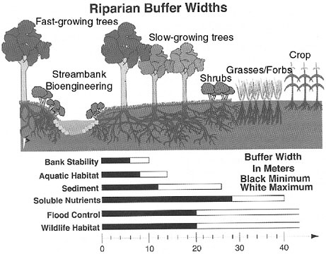
include regulation of stream temperatures through the canopy effect, streambank stabilization due to tree roots, provision of leaf litter and large wood, and provision of an undisturbed area for wildlife. Additional pollutant removal also occurs in this zone. The unmanaged forest zone is typically 15- to 30-ft wide, but a minimum width equal to mature tree height may be a more effective width for
|
BOX 5-10 An approach similar to the multiple-species riparian buffer system (Box 5-9) is the three-zone forest buffer proposed by Welsh (1991), as shown in Figure 5-12. Welsh suggests that the buffer area should be 20 percent of the contributing nonpoint source pollutant source area. Zone 1 is a permanent and undisturbed forested zone immediately adjacent to the stream. Zone 2 is a managed forest zone, just upslope of Zone 1, in which timber is periodically harvested. Zone 3 is the runoff control zone—a managed herbaceous strip, usually grasses, just upslope of Zone 2 that is used to control runoff. The three-zone forest buffers are specified for habitat and water-quality protection of waterbodies adjacent to cropland, pastures, and urban areas that are sources of diffuse pollution. Applicable waterbodies include perennial and intermittent streams, lakes, ponds, wetlands, and groundwater recharge areas. Recommended widths for all three zones range from a minimum of 100 ft to 150 ft, depending on soil type and land use (Welsh, 1991). There are no published studies on the overall effectiveness of the three-zone forest buffer design for water-quality protection. However, information on the individual effectiveness of forest and grass buffers is summarized later in this report. It is important to recognize that the MSRBS and the USDA’s three-zone buffers are not natural systems. They are engineered to approximate the functioning of natural riparian areas and achieve site-specific water-quality and habitat goals. As noted previously, this natural riparian buffer system may not be applicable in many areas of the Midwest because such landscapes are highly modified from their natural state. 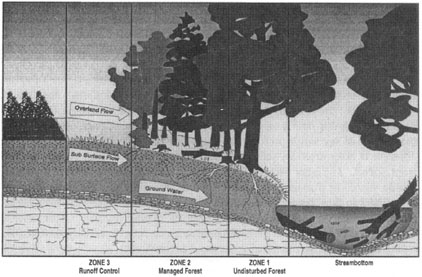 FIGURE 5-12 Three-zone forest buffer. SOURCE: Reprinted, with permission, Lowrance et al. (1985). © 1985 by Soil and Water Conservation Society. |
restoring habitat functions. The NRCS requires no less than 35 feet for the undisturbed forest zone and the managed forest zone combined.
Effectiveness of Buffers. Numerous studies have confirmed the role of upland grass buffers and riparian buffer zones for controlling nonpoint source pollution from agricultural and urban areas. Some of these findings are presented in Table 5-2 for various pollutants in overland flow. In reality, most buffers and riparian areas achieve only a fraction of their reported pollutant trapping potential. Most of the trapping studies reported by researchers have been short term in nature and were conducted under very controlled conditions that minimized the influence of factors—such as concentrated flow and long-term accumulation of pollutants—that influence riparian zone performance in nature. In addition, most of these studies report on riparian zone effectiveness for water-quality protection only in the first few years after establishment. These studies are probably not good indicators of the long-term performance of riparian buffers with respect to water-quality protection.
A few researchers have investigated the performance of forested buffers that have been in place below cropland for decades. Lowrance et al. (1983) studied existing forested riparian zones (mixed hardwood and pine) in a subwatershed of the Little River watershed near Tifton, Georgia and reported that the riparian zones reduced nitrogen and phosphorus loading in subsurface flow by 67 and 25 percent, respectively. Reductions in surface loadings were not reported. The authors recommended periodic harvesting of riparian vegetation to maintain nutrient removal efficiencies. In a second watershed-scale study, Cooper et al. (1987) used 137Cs data and sediment–soil morphology to estimate sediment trapping in two riparian areas in the Coastal Plain of North Carolina over a 20-year period. The results indicated that the riparian areas trapped 84 percent to 90 percent of the sediment lost from upland cropland. These studies may be more indicative of the long-term effectiveness of forested buffer zones for water-quality protection. However, because they both were conducted in low-gradient Coastal Plain watersheds, they may not be representative of riparian buffers in other physiographic regions.
It should be noted that neither the three-zone forest buffer nor the multi-species riparian buffer system are effective in removing dissolved contaminates from groundwater in agricultural watersheds where tile drains transport groundwater through the riparian buffer. To reduce pollutant loadings to receiving waters from tile drains, riparian buffers must include constructed wetlands or similar systems to treat tile effluents, as discussed in Box 5-11.
Managing for Success. The conditions necessary for effective riparian buffer performance can be achieved through management. It should be noted that many of the management measures recommended for water-quality protection may not be desirable for enhancing other riparian area functions. For example, periodic
TABLE 5-2 Reported Effectiveness of Buffer Zones for Water Quality Protection
|
Citation |
State |
Width (m) |
Buffer Type |
Reported reductionsa |
|
Young et al., 1980 |
MN |
25 |
Grass |
Sediment 92% |
|
Horner and Mar, 1982 |
|
61 |
Grass |
Sediment 80% |
|
Dillaha et al., 1989 |
VA |
4–9 |
Grass |
Sediment 84%, phosphorus 79%, nitrogen 73% |
|
Magette et al., 1989 |
MD |
5–9 |
Grass |
Nutrients <50% |
|
Schwer and Clausen, 1989 |
VT |
26 |
Grass |
Sediment 45%, phosphorus 78%, total Kedall N 76%, ammonia 2% |
|
Ghaffarzadeh et al., 1992 |
|
9 |
Grass |
Sediment 85% |
|
Madison et al., 1992 |
|
5 |
Grass |
Nitrate and orthophosphorus 90% |
|
Schellinger and Clausen, 1992 |
VT |
23 |
Grass |
Fecal coliform 30% |
|
Chaubey, 1994 |
AR |
24 |
Grass |
Nitrate 96%, phosphorus 88%, sediment 80%, bacteria 0% |
|
Mickelson et al., 1995 |
IA |
5–9 |
Grass |
Herbicides 28–72% |
|
Arora et al., 1996 |
IA |
20 |
Grass |
Herbicides 8–100%, sediment 40–100% |
|
Daniels and Gilliam, 1996 |
NC |
6–18 |
Grass |
Sediment 30–60%, total Kedall N 35–50%, ammonia 20–50%, nitrate 50–90%, phosphorus 60%, orthophosphorus 50% |
|
Nichols et al., 1998 |
AR |
18 |
Grass |
Estrogen 98% |
|
Lee et al., 1999 |
IA |
3–6 |
Grass |
Sediment 66–77%, total-N 28–42%, nitrate 25–42%, total-P 37–52%, orthophosphorus 34–43% |
|
Lee et al., 2000 |
IA |
7–16 |
Mixed |
Sediment 70–90%, total-N 50–80%, nitrate 41–92%, total-P 46–93%, orthophosphorus 28–85% |
|
Lynch et al., 1985 |
|
30 |
Forest |
Sediment 75–80% |
|
Shisler et al., 1987 |
MD |
19 |
Forest |
Nitrogen 89%, phosphorus 80% |
|
Lowrance, 1992 |
GA |
7 |
Forest |
Nitrate (groundwater) 100% |
|
aNote that reported reductions were not necessarily adequate to meet water-quality goals. These studies simply quantified the experimental reductions measured. |
||||
|
BOX 5-11 Over 50 percent of the agricultural land in the central Cornbelt area of the United States is drained by surface and subsurface tiles, resulting in spring nitrate levels in surface waters that often exceed 10 ppm. For example, in the Embarras River of east central Illinois, tiles drain 70 percent to 85 percent of the cropland, and total N losses average 39 kg/ha/yr (David et al., 1997). Effluent from tile drainage accounts for 68 percent to 91 percent of the total N load (Kovacic et al., 2000) and 46 percent to 59 percent of the phosphorus load to the Embarras River (Xue et al., 1998). Because of the extensive tile drainage and bypassing of riparian biological processing, buffer zones will be significantly less effective in reducing nitrate levels in these areas, although they still have many other benefits. To reduce pollutant loadings in tile-drained watersheds, riparian buffers should include constructed wetlands or similar pollutant treatment systems. Constructed wetlands are built specifically to receive tile-drained water prior to its delivery to the stream network. Typically, the constructed wetland is a 0.5- to 1-m-deep depression, or it is created through construction of an earth berm. It is designed to maximize water contact with the soil substrate and plants through a series of baffles or other structures to guide the water (Kovacic et al., 2000; Schultz et al., 2000). The constructed wetland is typically located adjacent to the stream, thus reducing impacts on cropland and intercepting the greatest quantity of water. Guidelines for wetland size and the ratio of wetland area to acres drained vary from 1:100 (Schultz et al., 2000) to 1:15–20 (Kovacic et al., 2000) and depend upon design, precipitation, and other factors. Initial investigations into the ability of constructed wetlands to reduce pollutant loads are promising. During a three-year evaluation in Illinois, constructed wetlands removed 37 percent of total N; when coupled with a 15.3-m buffer between the wetland and the stream, an additional 9 percent was removed (Kovacic et al., 2000). Future research is needed to develop a better understanding of wetland performance under varying hydrologic and soil conditions as well as an improved understanding of optimal siting of wetlands in relation to the drainage network. Large-scale implementation of this strategy will require an economic evaluation that must take into account the availability of funding, the value of agricultural cropland in areas optimal for wetlands, and the potential beneficial uses of the wetlands for wildlife habitat, aesthetics, and recreation. |
burning, mowing, and harvesting of grasses and biomass for nutrient removal and buffer maintenance can affect habitat values.
First, riparian buffers are most effective at pollutant removal when overland and shallow subsurface flow are distributed uniformly across the riparian zone as sheet flow. Areas where flows concentrate have shorter detention times, and pollutant-removal mechanisms in these areas can be overwhelmed. Unfortunately, the majority of overland flow and a significant portion of the shallow subsurface flow from contributing upland areas naturally concentrates before reaching the
riparian area. In agricultural areas, overland flow tends to concentrate within 100 meters (Dillaha et al., 1989), while in urban areas, stormwater concentrates into channelized flow within as few as 25 m (75 ft) of its source (Whipple, 1993; Schueler, 1996). In some cases, water-spreading systems can be used to disperse highly concentrated flows across a riparian area. Installation of water bars at intervals across the riparian zone (perpendicular to the slope) can force overland flow to flow across rather than parallel to the riparian area. The runoff control zone of riparian buffers should be maintained by grading out rills, gullies, and excessive sediment deposits to encourage shallow sheet flow.
Second, high infiltration rates will reduce runoff volumes and velocities and the transport of dissolved and adsorbed pollutants associated with overland flow. For this reason, dense herbaceous vegetation or litter layers, which offer high resistance to overland flow, are preferred. Regular mowing of herbaceous cover (cool season grasses) in the runoff control zone 2–4 times per year will encourage thick growth at ground level and high resistance to overland flow. Periodic burning of warm season grasses in the runoff control zone is required for similar reasons. Herbaceous vegetated buffers that have accumulated excessive sediment should be plowed, disked, and graded, if necessary, and re-seeded to reestablish shallow sheet flow conditions. This is practical only in the runoff control zone where trees and shrubs are not present.
Third, both adsorption of dissolved pollutants and microorganisms to soil and plant surfaces and assimilation of dissolved pollutants, particularly nutrients, by plants and soil microorganisms are enhanced as contact times increase. Longterm nutrient removal is the result of nutrient uptake and storage in woody biomass that is not lost at the end of the growing season.
Finally, if water quality protection is the primary objective, priority should be given to installing and maintaining buffers along smaller streams (first- and second-order) rather than higher-order streams (USDA-NRCS, 2000a). This is because only a small portion of the flow in higher-order streams actually flows through their adjacent riparian buffers. Table 5-3 illustrates the relationships between stream order, number of streams, and length of streams. If hydraulic inflow and nonpoint source pollutant loading to streams are assumed to be proportional to stream length, then ephemeral, first-, and second-order streams account for approximately 90 percent of both total stream length and total pollutant loading (Table 5-3). If riparian areas are not functioning along ephemeral drainageways, then approximately 63 percent of the average annual stream loading will enter the riparian areas of higher-order streams as channel flow, with little opportunity for pollutant attenuation by riparian processes. Brinson (1993) reached the same conclusion—that wetlands are the most effective along lower-order streams, where they have been proposed for water-quality protection.
Research Needs. A number of critical questions hold the key to a more holistic utilization of riparian buffers as a landscape feature for both habitat
TABLE 5-3 Relationship Between Stream Order and Length for Any Area Assuming One 10th-Order Stream
|
Stream Order |
Number of Streams |
Average Length (km) |
Total Length (km) |
Percentage of Cumulative Length |
|
Ephemerala |
6,271,000 |
0.7 |
9,000,000 |
63 |
|
1 |
1,570,000 |
1.6 |
2,526,100 |
18 |
|
2 |
350,000 |
3.7 |
1,295,250 |
9 |
|
3 |
80,000 |
8.5 |
682,200 |
5 |
|
4 |
18,000 |
19 |
347,550 |
2 |
|
5 |
4,200 |
45 |
189,200 |
1 |
|
6 |
950 |
103 |
97,800 |
1 |
|
7 |
200 |
237 |
47,300 |
<1 |
|
8 |
41 |
544 |
22,300 |
<1 |
|
9 |
8 |
1,250 |
10,000 |
<1 |
|
10 |
1 |
2,896 |
2,900 |
<1 |
|
Cumulative |
— |
— |
14,204,164 |
100 |
|
aValues for ephemeral streams extrapolated from relationships of 1st- to 10th-order streams (R2=0.99) SOURCE: Adapted from Leopold et al. (1964). |
||||
enhancement and water-quality protection. For example, given the enormous variability in reported best management practice effectiveness for pollutant removal (Table 5-2), what riparian zone width is required to meet site-specific pollutant reduction goals? What are the width requirements for each of the riparian subzones (grass/forb, managed forest or shrub, unmanaged forest/forest)? Under what conditions is each of those subzones required? What type of vegetation should be used for each of the subzones, and how will the vegetation composition affect pollutant/nutrient sequestration and habitat values? How can riparian buffer zones be managed to maximize long-term nutrient/pollutant removal? Are habitat protection goals compatible with pollutant reduction goals? An even more detailed list of buffer research needs were recently identified by a panel of 51 stakeholders (researchers, program administrators, and agricultural and conservation organization representatives) at the National Conservation Buffer Workshop (SWCS, 2001).
Answering these questions will require long-term and expensive experimental studies. Fortunately, it may be possible to answer many of the crucial questions in the near future using process-based riparian zone models such as the Riparian Ecosystems Management Model (REMM) (Inamdar et al., 1999; Lowrance et al., 2000), which is currently under development. REMM simulates long-term sediment transport, plant uptake, nutrient transport, and denitrification in riparian ecosystems and may provide a means of selecting vegetative species and riparian widths required to meet site-specific water-quality goals.
Infield Conservation Practices. Many types of buffer systems are used in agricultural and urban landscapes. Some are located in riparian areas, but most are situated upslope of riparian areas and are designed to keep sediment, agricultural chemicals, and organic matter in the field where they are viewed as valuable natural resources rather than pollutants. Many in the agricultural conservation community prefer to focus on infield BMPs and view riparian buffer zones as a BMP of last resort for water-quality protection.
Infield practices are similar to individual components of the three-zone riparian buffer systems described earlier. For example, a common practice is to place vegetative barriers (USDA-NRCS, 2001) on the contour between strips of row crops. These filter strips are primarily used to prevent sediment loss, but they also trap other potential pollutants. If located within the field, they help maintain agricultural productivity by conserving sediment and nutrients. If located at the lower edge of fields, their principal purpose is for water-quality protection. A similar function is provided by field borders (USDA-NRCS, 1999b). Although their primary purpose is for use as a turn row for agricultural machinery, if located on the downslope edges of fields, they can trap pollutants. Field borders are also useful in providing a buffer to reduce aerial drift of ground-applied pesticides. Contour buffer strips consist of alternating strips of row crops and close-growing herbaceous crops (USDA-NRCS, 1999c). Both are generally harvested. The herbaceous strip is used to detain and utilize sediment and nutrients leaving the more erosion-prone row-crop strips. Every two to four years, the herbaceous and row-crop strips are interchanged.
Windbreaks or shelterbelts (USDA-NRCS, 2000d) and herbaceous wind barriers (USDA-NRCS, 1994) can be designed to prevent wind erosion and to protect crops, livestock, and structures from wind-related damage. They are planted perpendicular to the prevailing wind direction and are usually composed of trees, but shrubs and tall herbaceous species are also used. Because of their effectiveness in trapping wind-blown sediment, however, they usually evolve into terraces that may interfere with overland flow and promote concentrated flow. Although windbreaks can be narrow (less than 20 feet wide), they do provide limited habitat for wildlife.
Grassed waterways (USDA-NRCS, 2000e) are an infield practice designed to prevent gully formation by transporting concentrated runoff downslope in a non-erosive manner. They are constructed by grading ephemeral drainageways to more stable shapes and then vegetating them with an erosion-resistant grass. They are typically designed to convey the runoff from extreme storms (10-year return interval, 24-hour duration) without damage and to maintain velocities that will minimize sediment deposition. In smaller storms, however, they do trap some sediment.
Finally, hedges composed of warm season grasses such as switchgrass (Schultz et al., 2000) can be used to form living terraces that function much like silt fences on construction sites to temporarily detain overland flow and induce
deposition of larger sediment particles. They also disperse runoff and provide habitat for some species. Grass hedges are generally narrow, 2–10 feet wide, and are often used in conjunction with lower-growing herbaceous buffer strips.
Although these practices are located upslope, they are extremely beneficial to riparian area functioning, because they reduce pollutant loadings and prevent overloading of pollutant-removal processes in riparian areas.
Conclusions and Recommendations on Riparian Buffers for Water Quality Protection
Engineered and constructed buffer zones are a valuable conservation practice with many important water-quality functions. Under proper conditions, these buffers are highly effective in removing a variety of pollutants from overland and shallow subsurface flow. They are most effective for water-quality improvement when hillslope runoff passes through the riparian zone slowly and uniformly and along lower-order streams where more of the flow transverses riparian areas before reaching the stream channel.
Riparian buffer zones should not be relied upon as the sole BMP for water-quality improvement. Instead, they should be viewed as a secondary practice or BMP of last resort that assists infield and upland conservation practices and “polishes” the hillslope runoff from an upland area.
Riparian buffer zones must be designed using a multiobjective approach that considers all their ecological functions. Even when they are marginally effective for pollutant removal, riparian buffers are still valuable because of the numerous habitat (see below), flood control, groundwater recharge, and other environmental services they provide. Unless new evaluation procedures are developed that consider both the water quality and ecological functions of riparian areas, it is unlikely that riparian zone size (width and length) and composition (vegetation types, other features) will be determined in a way that optimizes their potential for environmental protection.
Cattle Exclusion and Grazing Systems
Several methods have been advanced for managing livestock, particularly cattle, to restore and protect riparian areas:2
-
fencing to exclude cattle,
-
extended (e.g., five years or longer) rest of the entire grazing unit (pasture or allotment),
-
specialized grazing systems,
-
herding practices,
-
changing the season of use, class of livestock, or stocking intensity,
-
attracting livestock away from riparian areas with upland water sources or mineral or feed supplements and shade,
-
culling herds or breeding animals to eliminate “riparian loafers,”
-
eliminating grazing from the entire grazing unit,
-
revegetating with woody species, and
-
constructing drift fences.
Of the strategies listed above, exclusion is by far the most effective means of restoring riparian areas damaged by cattle. The efficacy of each method depends in part on the site potential, the area’s grazing history and state of depletion, and the management goals and timeframes for achieving those goals. Some of these management tools are BMPs, which have been adopted by states or recommended by EPA for addressing livestock-related nonpoint source pollution of surface waters (EPA, 1993; Mosley et al., 1997; Sheffield et al., 1997).
Exclusion. Excluding livestock from streams can yield significant, even dramatic, benefits to riparian areas and has consistently resulted in more rapid restoration of riparian areas than other management practices (Ohmart and Anderson, 1986; Elmore and Kauffman, 1994; Fleischner, 1994). Numerous studies have shown a marked difference between the riparian vegetation (and often bank and soil stability) in ungrazed areas compared to grazed areas—with ungrazed areas uniformly being healthier (Gunderson, 1968; Rinne, 1988; Huber et al., 1995; extensive review in Belsky et al., 1999; McInnis and McIver, 2001). For example, Schulz and Leininger (1990) compared areas from which livestock had been excluded for 30 years to study plots where grazing had continued but at a stocking rate reduced by more than two-thirds from the 1939 level. The researchers found that vegetative cover (excluding forbs) was significantly greater in the exclosures, while grazed areas had four times more bare ground. Willow densities were similar between the two areas, but plants were shorter in grazed areas. Even along intermittent streams, excluding cattle can lead to development of significant riparian vegetation (Anderson, 1993). Many researchers have concluded that riparian areas need to be managed separately from upland portions of a grazing unit and that restoring riparian areas will depend on excluding cattle by fencing (Olson and Armour, 1979; Platts and Wagstaff, 1984; Bromberg and Funk, 1998). Exclusion may be the only option in areas where landform limits cattle use to the riparian area and immediately adjacent uplands (e.g., in narrow,
steep sided canyons) or where riparian soils remain saturated throughout the year (e.g., seeps and bogs).
Although nearly all researchers seem to agree that improvements in ecological conditions will result following exclusion, they disagree as to the rate, extent, and predictability of recovery. Improved riparian and aquatic conditions may occur within 4–10 years after protection by fencing; this includes reestablishment of shrubs and trees even in heavily damaged areas (Rickard and Cushing, 1982; Skovlin, 1984). Clary and Webster (1990) estimated recovery times of 1–15 years or longer, while Belsky et al. (1999) suggested that initiation of recovery alone might take 2–15 years. Estimates of benefits achieved within five years range from 15 percent to 75 percent of the potential for a given site (Platts and Raleigh, 1984; Skovlin, 1984).
Although riparian vegetation may respond quickly to livestock exclusion, stream morphology usually improves more slowly, and fish populations may not improve at all (at least initially) (Platts and Wagstaff, 1984). Schulz and Leininger (1990) observed that trout biomass and fishing opportunities were greater in exclosures than in grazed areas. Similar results were obtained by Hubert et al. (1985) who documented improved habitat for brook trout as a result of livestock exclusion and stocking rate reductions. However, other studies have observed no relationship between grazing pressures and fish populations (Rinne, 1988). Rinne (1999) warns that there is a lack of peer-reviewed literature containing sound data on grazing–fish relationships, suggesting that this is an important area of future research.
In the West, excluding livestock has few if any adverse ecological consequences for riparian areas, although there are other disadvantages. In some more mesic areas, excluding livestock might result in rank growth of vegetation or undesirable thatch accumulation. As Box 5-12 reveals, perhaps the biggest draw-back to fencing riparian areas is cost. Most public land ranching operations do not turn a profit, and ranchers oppose any management changes that will increase costs (Wilkinson, 2001). Suggestions to fence cattle out of streamside areas have been labeled impractical except in rare circumstances, and opponents contend that intensive livestock management, for instance by specialized grazing systems, can restore streams at a lower cost (Swan, 1979). Finally, while potential benefits of exclusionary fencing are significant, some can be difficult to quantify, making it hard to balance them against the costs of construction and maintenance, lost forage, and possible negative impacts to wildlife and recreational users. In part for these reasons, several western researchers have urged more research into innovative grazing management strategies that would not require fencing and permanent exclusion of livestock (Olson and Armour, 1979; Platts and Wagstaff, 1984).
Where exclusion of cattle from riparian areas is not an option, changes in grazing system, season of use, or stocking rates, alone or in combination with fencing and with utilization monitoring, are methods for reducing livestock-related impacts. Reports of the effectiveness of changes in grazing management
|
BOX 5-12 Fencing is the most expensive grazing management strategy in terms of initial capital expenditure and annual upkeep. Reported capital and annualized costs (in 1991 dollars, annualized at 8% interest over 10 years) for permanent fence construction range from $2,640 and $324 per mile, respectively, in the Great Lakes region to $4,015 and $598 per mile, respectively, in Alabama (EPA, 1993). The annualized cost of net wire fences in Alabama exceeded $877 per mile. The Iowa State University and Purdue University Extension Services report the following construction and maintenance costs (per mile per year in 1998 dollars) for straight perimeter fencing (excluding gates): $964 for woven wire, $748 for barbed wire, $520 for non-electric high tensile, and $392 for electric high tensile (Mayer, 1999). Fence construction costs in the interior West have been estimated at $2,000–6,000 per linear mile, with maintenance costs estimated at $25–250 per mile per year. Sheep (woven wire) fencing or “lay-down” fencing is much more expensive than the typical 4-wire cattle fence (PCL Foundation, 1999). In smaller, managed pastures in the East, it is more feasible to protect riparian areas using much cheaper one- or two-strand electric fences (although Alabama reported capital and annualized costs for electric fencing of $2,676 and $399 per mile) (EPA, 1993). Costs of conventional perimeter fencing depend on terrain, contour, number of corners, soil, vegetation type, etc. Providing alternate stock watering facilities entails additional costs—e.g., for developing springs, building pipelines or troughs, or installing tanks. Olson and Armour (1979) estimated that fencing 9,000 (of an estimated 19,000) miles of streams on BLM lands would cost $45.6 million. The researchers assumed an average cost of $2,400 per mile of fence, and 19,000 miles of fence. They further estimated that trout in the protected stream segments could increase by 300–400 percent. This translated to a conservative $78.2 million increase in the value of sport fishing on BLM lands, yielding a “simplistic first-year benefit–cost ratio of 1.66”—i.e, a “return of $1.66 for each dollar invested.” Platts and Wagstaff (1984) estimated that an increase of 47 fishing days per mile per year would be necessary to offset the cost of fencing. Although fencing costs often exceed the gains in fishery value, fencing may be necessary if both grazing and fishing are to be continued, they concluded, because few alternatives are sociologically or ecologically acceptable. A potential cost of fencing cattle out of riparian areas is the cost of providing alternate livestock forage. The amount of forage foregone will vary with numerous factors, including the geographic region, climate, elevation, and vegetative community. Platts and Wagstaff (1984) estimated that a 100-foot-wide corridor, encompassing about 12 acres per mile, would contain 12 AUMs in the West. (Western public land allotments as a whole typically provide 1 AUM per 13–16 acres.) The cost to national livestock production of excluding livestock from public land riparian areas would be insignificant, given that all public lands contribute only about 2 percent of the nation’s livestock feed. |
are highly variable, however, and efficacy is difficult to evaluate without reference to site-specific conditions and unless studies are continued over a sufficient time period. Changes in streamside vegetation will occur sooner than changes in hydrology or sediment loads. Grazing management may bring about positive changes in the former, but not in the latter; thus, a short-term (less than 5-year)
|
The cost of forage foregone would be reduced if riparian areas were fenced and grazed separately from the rest of the grazing unit, rather than put entirely off limits to grazing. It is useful to compare riparian fencing costs in the West to the current federal grazing fee of $1.35 per AUM. Given the estimate above of 1 AUM per 13–16 acres (or 0.06–0.08 AUM per acre), the grazing fee generates an average of 8–10 cents per acre. (The actual forage contribution of riparian areas is higher because of their productivity and attractiveness to cattle.) Even at the low fencing estimate of $2,000 per mile, fencing 1/4-mile-wide riparian corridors would cost more than $31 per acre enclosed. The narrower the riparian enclosure, the greater the disparity between fencing cost per acre and grazing fee revenue. Additional potential costs of fencing include the visual impact on some landscapes, potential disruption of native ungulate movement patterns, fragmentation of habitat, interference with recreational access, increased runoff resulting from bare ground brought about by cattle trailing along fences, and the contribution of cleared fencelines to the introduction and spread of exotic plant species (Wuerthner, 1990; Anderson, 1993; EPA, 1993; BLM and USFS, 1994; Noss and Cooperrider, 1994; Donahue, 1999). A sophisticated economic assessment of the efficacy of riparian fencing would compare all foreseeable costs to expected benefits (compare Platts and Wagstaff, 1984). Potential benefits include enhanced riparian functioning, enhanced habitat values, increased native species populations and recreation opportunities, reduced erosion, and improved water quality (Olson and Armour, 1979; Kauffman et al., 1983; Platts and Wagstaff, 1984; Wuerthner, 1990). An additional benefit can be improved cattle herd health, resulting from reduced exposure to waterborne bacteria and fewer leg injuries caused by crumbling streambanks (Bromberg and Funk, 1998). Some benefits (e.g., increased fishing or hunting use) may be easier to quantify than others (e.g., improved water quality or aesthetics). Fencing may be more appropriate and economical for larger blocks (e.g., 30-40 acres) of riparian meadows, although smaller, more homogenous riparian pastures may be more effective in achieving livestock management and restoration objectives (Mosley et al., 1997). Subdividing pastures into smaller squares, rather than wedge-shaped units, will reduce the amount of fence needed and the number of cattle trails, while allowing more efficient reduction of the distance to water (Hart et al., 1993). The possibility of future grazing of restored riparian meadows “will help amortize fencing costs” (Skovlin, 1984). Fencing can be economically feasible on streams with high fisheries potential. Studies in Idaho showed that trout were 1.5–4.5 times more abundant along ungrazed than along grazed areas (Keller and Burnham, 1982). The economic value of improved trout fishing has been estimated and can be significant (Dalton et al., 1998). When fencing or exclusion of livestock is necessary “for maintaining productive riparian and fishery habitats, the cost of special management pastures may not seem exorbitant” (Platts and Nelson, 1985a). |
study could misinterpret the overall effectiveness of the new management system. Livestock manager commitment is crucial, as improper implementation or lack of enforcement will reduce the effectiveness of any grazing management strategy (Platts and Nelson, 1985b; Clary and Webster, 1990; GAO, 1990; Ehrhart and Hansen, 1997).
Grazing Systems. Specialized grazing systems are “systematically recurring periods of grazing and deferment for two or more pastures or management units” (Skovlin, 1984). They include deferred, rotation, rest-rotation, and deferred rotation systems. Three-pasture rest-rotation is probably the most commonly used system (Masters et al., 1996). These systems contrast with continuous livestock use, which can be either season-long or yearlong.
The range management literature contains little if any evidence that these grazing systems, which were designed chiefly to maintain or improve forage species and optimize livestock production, will benefit riparian areas. Nearly all researchers agree that rest-rotation grazing alone will not restore or maintain riparian conditions (Hughes, 1979; Olson and Armour, 1979; Skovlin, 1984; Hart et al., 1993; but see Masters et al., 1996). Rest rotation reportedly works well when precipitation exceeds 15–20 inches per year and is predictably distributed (Busby, 1979), but few western rangelands meet these criteria. [In fact, 95 percent of BLM lands receive less than 15 inches of annual precipitation (Foss, 1960).] Grazing impacts on riparian areas can be minor if the period of use is sufficiently short. Mosley et al. (1997) recommend three weeks or less, though the appropriate period will depend on soil moisture conditions, timing during growing season, number of animals, etc. Suggested periods of use on the order of two to three days are likely to be too abbreviated to be practical for many operators (Davis and Marlow, 1990).
At least in the West, riparian area vegetation will be utilized under any stocking rate or grazing system because of cattle’s tendency to spend a disproportionate time in riparian areas (Bryant, 1982; Gillen et al., 1985; Howery et al., 1996). Indeed, riparian forage is often over-utilized, even when upland vegetation use meets the grazing system’s management prescription (Platts and Nelson 1985a,b,c). The smaller the fraction of the grazing unit occupied by the riparian area and the drier the surrounding uplands, the more likely and severe are the impacts.
Many researchers have recommended that more attention be given to developing grazing systems designed to improve and maintain riparian conditions. For example, Platts and Nelson (1985c) suggest that “longer rest periods (such as double rest-rotation) or deferred grazing that allows a protective vegetation mat to be maintained on the streambank during critical periods” are promising strategies that might avoid the need to exclude livestock completely. Mosley et al. (1997) contend that “adjusting [the] timing, frequency, and intensity of grazing in individual pasture units is more important than adopting a formalized grazing system.” They recommend that riparian areas not be grazed during “critical” periods (usually between late spring and early fall) more often than once every three or four years, and that annual grazing of riparian areas could occur during noncritical periods. Still others opine that uniform grazing can be achieved more economically by subdividing pastures and providing additional water than by implementing rotation grazing (Hart et al., 1993).
Season of Use. Differing viewpoints exist regarding the effect of season of use on maintaining or improving riparian area conditions (compare Platts and Raleigh, 1984; Platts and Nelson, 1985c; Elmore and Beschta, 1987; Clary and Webster, 1990; Masters et al., 1996; Phillips et al., 1999). The tendency of cattle to use riparian areas most heavily during hot periods (summer) apparently relates to water availability, forage availability and quality, and microclimate (temperature and humidity) (Enrenreich and Bjugstad, 1966; Bryant, 1982). For these reasons, grazing at these times or at the peak of the growing season is generally not recommended. But views regarding the effects of late-season grazing vary widely (Bryant, 1982; Kauffman et al., 1983; Platts and Nelson, 1985a; Conroy and Svejcar, 1991). According to one Montana study, use of riparian areas is related more to the timing and amount of precipitation, forage production and quality, and daily weather changes and insects (all or some of which can be difficult to predict) than to season alone (Marlow and Pogacnik, 1986). Regardless of the season, utilization should be monitored and kept within prescribed levels, and grazing may need to be ended early during drought conditions.
Stocking Intensity. Stocking rate, or grazing intensity, refers to the density of animals on a given area, and is usually described as light, moderate, or heavy.3 The failure of many studies to document stocking rates or to define terms such as heavy and moderate stocking makes it difficult to evaluate claims that reduced stocking intensity can improve riparian conditions. Even very short periods of heavy stocking may have hydrologic consequences (Branson, 1984), while little information is available on the hydrologic impacts of light to moderate grazing intensity (Skovlin, 1984). Clary (1990) observed relatively similar improvements in bank stability, willow height, and cover when historically heavy stocking rates were reduced to no, light, or moderate stocking, and concluded that light to medium spring cattle use was compatible with these riparian habitats (in Idaho). Gifford and Hawkins (1978) concluded that infiltration and sediment loss rates for lightly grazed, moderately grazed, and ungrazed areas were not statistically different. But Blackburn (1984) cautioned that if an area has been severely overgrazed, reducing stocking to moderate levels may not reduce sediment loss from the watershed. In some circumstances, reducing both livestock numbers and the length of the grazing season may not be sufficient to achieve management objectives (Chaney et al., 1990).
Measuring Utilization. Increasingly, public land managers are using stubble heights of the most palatable herbaceous species as an indication of acceptable grazing use of riparian areas. Effective use of this indicator requires frequent monitoring and the ability to remove cattle quickly when conditions so require. Although no standards have been established, EPA recommended to BLM that a resource management plan for an area in Colorado limit autumn utilization of streamside vegetation to 30 percent with 4–6 inches of stubble remaining at the end of the grazing season, and it recommended that the plan require stubble heights greater than 6 inches in critical fishery habitats (EPA, 1992). A national forest proposed to adopt a criterion of 6-inch stubble height or 30 percent utilization (whichever occurs first) for forage utilization directly adjacent to the stream on Curlew National Grassland, Idaho (Federal Register, 1999).
At stubble heights of less than 3 inches, continued livestock use can cause damage to riparian areas (including shrub use and bank breakage) within a few days. Hall and Bryant (1995) recommend that livestock be moved when stubble height of preferred species approaches 3 inches. Stubble heights greater than 6 inches may be required to protect critical fisheries or easily eroded streambanks (Clary and Webster, 1990). Clary (1990) reported that nearly all variables indicative of favorable salmonid fisheries habitat improved when grasses in riparian pastures were grazed to not less than approximately 5–6 inches.
The remaining methods for managing grazing (of those listed on page 386) are of generally less utility for protecting riparian areas. Culling and breeding strategies intended to develop a herd that avoids riparian areas are apparently not widely used. Changing from cattle to sheep can lessen the impacts of grazing on riparian areas because sheep are more easily herded, can negotiate steeper terrain, and tend to spend less time near water or in valley bottoms (Busby, 1979). But because of market factors and individual operator preferences, this strategy has only limited application. Herding and “frequent riding,” if constant and assiduous, can be useful to keep cattle away from riparian areas (Platts, 1990). This is most easily achieved where pastures are relatively small and/or animals are monitored closely. Herding is of limited practical usefulness in the West, where cattle are often grazed over extremely large pastures and/or are simply turned out at the start of the grazing season and are rounded up at the end.
Attracting livestock away from riparian areas with mineral or feed supplements and alternate water sources can help limit cattle use of riparian areas (Skovlin, 1984; McInnis and McIver, 2001), but the efficacy of this approach depends significantly on climate, weather factors, terrain, and animal behavior. Off-stream livestock watering combined with fencing is one of the most common strategies for protecting riparian areas in more mesic parts of the country. But it is much less effective in the arid West, especially in steep terrain, where there is little other shade, and/or during hot weather (Clawson, 1993). Supplying alternate water sources in arid, steep terrain can be logistically difficult. Moreover, because cattle avoid steep slopes (> 35 percent) where possible, the steeper and
drier the grazing land adjacent to the riparian area, the less likely it is that these tools will be effective (Cope, 1979; Platts, 1990).
Conclusions and Recommendations on Grazing
Excluding cattle from riparian areas is the most effective tool for restoring and maintaining water quality and hydrologic function, vegetative cover and composition, and native species habitats. If ecological restoration is the primary management objective, and if cost is not an obstacle, excluding livestock (or extended rest from grazing) will likely be the preferred management strategy. Excluding livestock permanently from riparian areas may be desirable or even necessary because of the relative value or importance of non-livestock resources (such as recreation, endangered species habitat, or water quality) or because of the degraded condition of the area. Once ecological and hydrologic functions are restored, grazing in some cases could have minor impacts if well managed.
Even where grazing in riparian areas is excluded or properly managed, grazing also must be managed on uplands to protect riparian areas. Riparian conditions are a function not only of activities within the riparian area, but of upland conditions and activities as well. Any upland activities that contribute to excessive soil erosion or runoff can negatively impact riparian area condition and functioning.
Where cattle are not excluded from riparian areas degraded by livestock grazing, conditions will not improve without changes in grazing management. Changing the season of use, reducing the stocking rate or grazing period, resting the area from livestock use for several seasons, and/or implementing a different grazing system can lead to improvements in riparian condition and functioning. Improvements, e.g., in vegetation conditions, soil and water quality, and/or streambank stability, will depend in part on site conditions and potential.
Further research is needed concerning effective grazing management strategies in both the interior/arid West and more mesic areas of the country. As long as riparian lands continue to be used to produce livestock, research should address grazing systems or other strategies that could lessen the ecological impacts of livestock use. To be effective, grazing strategies must be site-specific. Management methods will also vary according to land ownership and land-use goals.
Riparian Buffers—Management for Habitat and Movement Corridors
Managing riparian lands for a diversity of plants and animals involves balancing multiple factors, all of which are accentuated in intensively managed or
developed landscapes. These factors include width and vegetative composition of the riparian area, activities within the riparian area and on adjacent lands, connectivity with other patches on the landscape, and potential negative edge effects such as those associated with modified microclimates, exotic plants, or increased predation or parasitism. These factors come into play for both riparian areas left in their natural state (for example, no-harvest buffers in managed forests) as well as engineered buffers (such as those designed for water-quality concerns). Given the multiple factors that must be considered when managing riparian buffers as habitat for plants and animals, it is no surprise that no single management prescription can optimize diversity in all situations.
Noss (1991) advocates an approach that seeks to optimize the width (distance from the water body) and variety of natural habitats in order to accommodate the full spectrum of native species. But it is unclear how a management plan can take into account the many different taxa that use riparian areas. To be truly comprehensive, management techniques—for rare sedges, neotropical migrant birds, and large carnivores, for example—would have to be similar. Or a particular species or suite of species would have to serve as an umbrella in the management of certain riparian areas. Vital to all situations are the identification and use of reference sites (described earlier) that can provide guidance in establishing and accomplishing management goals. Reference sites can provide an understanding of the potential functioning of riparian areas as habitat and movement corridors.
Habitat. Historically, emphasis in wildlife management has been placed on a single species—an organism-centered approach. With a single-species approach, however, management runs the danger of neglecting the interactions of organisms. As an alternative, Naiman and Rogers (1997) advocate examining influences via functional groups, a particularly useful construct for riparian areas. In this scheme, animals are grouped by primary activities associated with movement, dwelling, and feeding, as well as the habitat modifications produced by these activities. Instead of species-focused management, the authors advocate managing for spatiotemporal variability in populations as a way to perpetuate resilience in riparian areas. Similarly, Ilhardt et al. (2000) argue for a functional approach, where function is defined as a process that moves material between the terrestrial and aquatic portions of the riparian area and the width is designed to perpetuate selected functions (including animal habitat needs). A functional approach is more likely to foster consideration of a wider diversity of plants and animals than would be found only in the aquatic ecosystem and its immediate surroundings.
Buffer width required for habitat is almost always the first issue confronted by managers and is one of the most difficult to address. Substantial variability in required width has been observed in numerous studies. For example, strips at least 60 m wide are needed to maintain breeding habitat for forest-dwelling birds adjacent to a clearcut in the Laurentian Mountains of Quebec (Darveau et al.,
1995). A Vermont study in a mountainous landscape advocated widths of 75–175 m to optimize bird diversity (Spackman and Hughes, 1995), while a South Carolina study in bottomland hardwoods described the need for riparian areas 500 m wide (Kilgo et al., 1998). And these examples are drawn from only one taxon: birds! Brinson et al. (1981) graphically summarized the spatial distribution of selected riparian vertebrates in relation to streams, with distances ranging from a few meters in the case of salamanders to several kilometers in the case of herons (Figure 5-13). Far-ranging species such as cougar or bear might require widths that are measured in kilometers (Smith, 1993). Several tables of documented habitat widths for a variety of taxa are found in Verry et al. (2000). Increasingly, such information on widths, combined with data on reference sites, can be used by resource managers in their design of leave areas or engineered buffer strips, although the wide disparity in desired riparian widths associated with various taxa presents an ongoing challenge.
Any question of width must also include concern about negative effects associated with fragmentation of habitats, often loosely grouped under the term “edge effects.” Edge effects can result from reduction in habitat area as well from increases in isolation of habitat patches, predation and parasitism, and disturbance from adjacent lands (Noss, 1983; Robbins et al., 1989; Robinson, 1992). The linear nature of riparian areas, and the abrupt transitions between some uplands and riparian lands, make them particularly susceptible to such effects. Riparian areas severely affected by fragmentation and edge effects may cease to function as breeding habitat—particularly for birds (e.g., Robinson, 1992; Trine, 1998). Work in Maine conservatively estimated that negative edge effects adjacent to a clearcut extended 25–35 m into the adjacent forest (Demaynadier and Hunter, 1998). A bird community will persist, even in the narrowest riparian fringe, but often it is not the community that would have typified the riparian area in a less degraded condition. Clearly, a landscape approach is needed to address edge-effect issues when managing riparian areas for optimal biodiversity.
Management decisions in riparian areas must consider the potential simplification of habitat that can characterize degraded riparian areas. A loss of plant species, a reduction in understory diversity, the elimination of flooding or other disturbances such as fire, a reduction in amount of snags and woody debris, and disruptions of ecosystem continuity by roads, trails, or recreational facilities can lead to a parallel decline in animal diversity. In disturbed riparian areas, often only the most tolerant species remain, as was shown in a study from an Iowa agricultural landscape (Stauffer and Best, 1980). Likewise, in a comparative study of grazed and ungrazed riparian areas in Colorado, mammal and bird species needing more complex vertical structure and lush herbaceous understory were displaced in grazed areas by more tolerant species such as American robin and deer mouse (Schulz and Leininger, 1991). Similar findings of lower bird diversity and species richness, coupled with an increase in a few common spe-
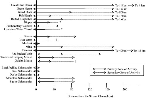
cies, were reported for the citrus orchards that have replaced cottonwood forests along the lower Colorado River (Wells et al., 1979).
Many of the engineered buffer zones employed in eastern and Midwestern agricultural landscapes exhibit a simplified vegetative diversity and structure. Thus, efforts have been made to increase habitat diversity with the planting of trees and shrubs to create a more varied agricultural field edge. Identifying native species for this purpose through the use of reference sites can be a formidable task where agricultural practices have so altered soil characteristics that they are no longer suitable for some native vegetation. The Plant Materials Program of the NRCS (www.nhq.nrcs.usda.gov) has begun to assemble information on the use of native plant species for conservation as well as to identify seed sources. In agricultural areas that were originally a mosaic of uplands and prairie sloughs, the establishment of trees and many shrubs represents creation of habitat that was not present in pre-settlement times. Nevertheless, these species can provide valuable habitat adjacent to intensively managed farmland, consistent with the management paradigm of naturalization (Rhoads and Herricks, 1996) whereby managers strive for diversity, stability, and self-regulation within the framework and constraints of human utilization of the natural resources. It should be noted that the use of such trees or plants could affect the trophic structure of the aquatic ecosystem by changing instream temperatures and acting as a source of carbon and energy inputs.
Managing riparian areas for wildlife may be as simple as identifying and eliminating those practices that render the area unsuitable as habitat. For example, timber harvest in forested riparian areas, even selective harvesting, produces changes in the forest and ground cover structure that often result in reduced habitat complexity and losses in species richness and abundance (Conner et al., 1975; Niemi and Hanowski, 1984), as well as changes in microclimates that may extend as much as 1,000 feet from a harvest (Brosofske et al., 1997). Before timber harvest is proposed for a riparian area, management objectives for plant and animal diversity need to be identified. For the most part, current silviculture in riparian areas employs the same techniques used on uplands—techniques that are based on a paradigm of relatively homogeneous forest patches and that fail to address the spatial and temporal diversity inherent in riparian areas. Some foresters, however, are working to develop approaches that are more compatible with the heterogeneity of the riparian ecotone (Ilhardt et al., 2000). For example Short (1985) advocates managing for optimized vertical structure of habitat within a riparian buffer. One might also consider ways to perpetuate the horizontal patchiness of vegetative types that typifies many riparian areas with carefully targeted selective harvesting. Substantial innovations in silvicultural and agricultural protocols are needed before most vegetative management will be effective at perpetuating diverse natural riparian communities.
Corridors for Movement. Riparian areas may provide the best opportunity for restoring linkages between larger patches of more natural ecosystems and promoting gene flow between populations (MacClintock et al., 1977; Noss and Harris, 1986; Mackintosh, 1989). This is particularly evident in developed landscapes where often the only remaining natural or semi-natural land exists along floodplains, or in agricultural landscapes where buffer zones planted for water-quality protection also serve a wildlife habitat function (Forman and Baudry, 1984; Barrett and Bohlen, 1991). Such riparian remnants frequently include wetlands where anthropogenic alterations have been limited.
Theoretical work on corridors (based on the discipline of biogeography) often involves modeling the probabilities of extinction in isolated patches versus interconnected patches (Simberloff and Wilson, 1969; Turner, 1989). Using this theory as a springboard, much attention has been paid to designing for the movements of large carnivores between reserves (Harris and Atkins, 1991; Grumbine, 1992; Noss et al., 1996). Applicable work has also drawn from percolation theory, which models different combinations of population dispersal characteristics and patterns of habitat boundaries to predict patterns of population growth and habitat utilization (Gardner et al., 1991). This type of analysis is useful in understanding how human disturbance disrupts movement of animals at the landscape scale (O’Neill et al., 1988).
With this theoretical underpinning, practical examples of corridor design and the benefits of corridors have multiplied. Of importance in any design is a consideration of quality of habitat within the corridor, as well as width and connectivity (Noss, 1993). Beier (1993) advocated the use of radiotelemetry data combined with geographical information system (GIS) mapping to identify the movement range for a far-ranging carnivore (such as the cougar) and there are several recent examples of this approach. For example, a GIS modeling analysis of movement corridors in the northern Rockies focused on a suite of species that included a carnivore (cougar), omnivore (grizzly bear), and ungulate (elk), under the hypothesis that a diverse combination of far-ranging species would provide a protective umbrella for a greater number of other species (Walker and Craighead, 1997). The Yellowstone to Yukon initiative, a conservation proposal emerging from a coalition of more than 140 environmental groups, seeks to preserve and create a series of wildlife corridors that will link populations of bear, wolves, and other large predators from Yellowstone National Park to Canada’s Yukon Territory. These corridors are based fundamentally on riparian areas and mountain ranges (The Wildlands Project, http://www.twp.org). Similarly, in Florida a GIS analysis was conducted to link significant reserve areas with the most appropriate and effective corridors; identification of linkages relied heavily on inland and coastal riparian areas (Hoctor et al., 2000). “Rewilding” is the term that has come to be applied to this approach of creating and preserving connectivity among large wild reserves, with a focus on the roles of species—frequently large carni-
vores—whose influence on ecosystem function and diversity is disproportionate to their numerical abundance (Soulæ and Noss, 1998). Riparian areas inevitably figure in the rewilding approach to landscape-scale corridor design.
Skeptics have accused managed riparian corridors of facilitating the spread of pests and diseases (Forman, 1995), and they have complained of a perceived deficit of studies regarding the effects of riparian zone design and management on biodiversity (Wigley, 1996). However, a considerable body of data exists for a variety of taxonomic levels from diverse ecoregions (Karr, 1996). Assessment of corridors is a significant challenge that continues to be addressed using both economic and scientific frameworks (Diamond et al., 1976; Simberloff et al., 1992). Often, corridors used by organisms have been designed by humans for other functions, which confounds any assessment of their effectiveness.
Solutions for providing movement corridors can be costly. The cost of one bridge that allows animal movement along a river under a road is an estimated 13 times greater than that of the usual bridge (Simberloff and Cox, 1987). Increasingly, movement corridors are being considered during major highway planning (Smith, 1999). Nevertheless, ongoing study is needed to assess the effectiveness of such created crossings. Studies from Banff National Park in Canada indicate that the effectiveness of constructed wildlife crossings can be compromised by recreational use of the same areas (Clevenger and Waltho, 2000). The time scale over which corridors may function can also make it difficult to assess effectiveness. For example, riparian areas that function as refugia for rare plants may act as migration corridors over hundreds of years. All these factors make it difficult to design and manage corridors and to assess their cost-effectiveness (Hunter, 1996). In spite of gaps in scientific and economic knowledge, there is little question that reestablishing connectivity of riparian areas as a means of counter-acting habitat fragmentation is crucial for long-term species survival and perpetuation of biodiversity (Noss, 1993; Walker and Craighead, 1997; Soulæ and Noss, 1998).
Conclusions and Recommendations on Riparian Buffers for Habitat
Riparian areas—both natural reserves and managed buffer zones—provide some of society’s best opportunities for restoring habitat connectivity on the landscape. Identification, mapping, and assessment of these areas are needed. Management of riparian areas in ways that optimize their value as habitat and movement corridors for plants and animals will require planning and action at both site-specific and landscape scales.
Much riparian buffer zone management suffers from focusing on a single species or taxon. Integrated management that uses a functional approach and seeks to optimize habitats for a variety of native species is needed. Integrated
management should include the use of reference sites and monitoring and should focus on the rehabilitation of native vegetation. Management of riparian areas should shift from focusing on stable populations of individual species to managing these species for variability as well as for their interactive roles in the ecosystem.
Current silvicultural and agricultural management approaches do not adequately address the habitat values of riparian areas. Most forestry buffers, fenced riparian exclosures, and agricultural buffers have the protection of water quality (or sometimes fisheries) as their main focus. These water-quality protection buffers are usually considerably less diverse structurally and vegetatively than they would be if wildlife habitat were actively considered in their planning.
Controlling Exotic Species
Because of their great impact on biodiversity and ecosystem function, as well as the economic burdens they exact, the control of exotic species is often a high priority in the management of riparian areas. Approaches to exotic species control include hand removal, mechanical removal, herbicide applications, controlled burns, controlled flooding, and biological controls. Biological controls essentially involve reestablishing the natural control mechanisms exerted by herbivores and pathogens in the native ranges from which exotic species come. Though very effective control has been achieved in many circumstances, there are no universal prescriptions for control of exotic species in riparian areas. The effectiveness of the various control methods will depend on the growth habit of the particular exotic species and its reproductive strategy, the extent of the infestation including whether it is urban versus rural or near critical habitat for endangered species, and the state of knowledge and of testing concerning potential biological control agents.
Control strategies must also be tailored to the relative costs and benefits, which vary among species and with land use conditions. Because these costs and benefits can be difficult to quantify, there is considerable debate in both the scientific and political arenas about whether certain exotic species can and should be eradicated from riparian areas. For example, there is no effective control agent for Chinese privet. Other species, such as saltcedar, are so widespread (1 million acres in the USA) that eradication is impossible. In addition, eradication of saltcedar is complicated by the discovery of its use as nesting habitat for the southwestern willow flycatcher, a federally listed endangered species. Each situation must be assessed in terms of the forgoing constraints, as well as whether the removal activity and associated habitat disturbance, including the application of herbicides, will result in more good than harm. Specific examples of control strategies for three exotic plant species in riparian areas are described in Box 3-4.
Managing Other Activities
Human activities and land uses have resulted in the widespread alteration of riparian areas along rivers and other waterbodies across the United States. By changing these activities, many of these riparian areas can be ecologically restored and improved. In some cases the types and extent of needed change will be minor and relatively easy to implement, as in designating leave areas exempt from traditional agriculture, grazing, or forestry. For other activities, restoration will require a new understanding of why riparian areas are important. Through continued research, educational programs, tax incentives, awards, regulations, legislation, and perhaps other approaches, the ecological importance and intrinsic values associated with these lands may be better balanced against the competing wants and needs of a modern society.
Recreation
Although it may seem insignificant compared to other land uses, recreation can impair riparian area functioning to a substantial degree in many areas and must be part of riparian management plans (e.g., Loeks, 1985). Managers of recreation must consider not only its impacts on the aquatic ecosystem—which has been the usual focus of water-based recreation (Field et al., 1985)—but also on the riparian area itself (see Chapter 3). Fortunately, the public tends to place a high value on the natural habitat present along streams and drainages (Black et al., 1985).
Some of the most relevant research regarding management of recreational activities in riparian areas comes from work on greenways. A greenway is a linear open space that is more natural than the surrounding area (Smith and Hellmund, 1993); it is typical of many recreational lands along rivers, lakes, and coasts. The challenge in the management of greenways is to preserve natural functions while still allowing for human enjoyment of these areas.
Management of recreational activities in riparian areas involves a combination of careful design, limitation of use, and public education (Cole, 1993). A frequent concern is the disturbance of soil, plants, and animals by placement and use of trails and roads. Conservation-oriented trail design suggests making use of existing roads and trails (unless they are degrading the area) rather than cutting new paths. Ideally, before designing public access to a riparian area, surveys should be conducted for rare or sensitive plants and animals or culturally sensitive sites that might be disturbed by human use, so that impacts can be minimized. Rather than placing the trail entirely within the riparian area, trails should allow access and view points in discrete locations (Trails and Wildlife Task Force, 1998). Durable areas should also be sought out as locations for placement of recreational facilities (Cole, 1993). Placement should also consider the inevitable negative edge effects on surrounding natural areas and should seek to mitigate these with buffer zones or screening. Having well-identified, highly devel-
oped riparian recreation sites such as marinas, overlooks, and picnic grounds can also channel a high percentage of users into discrete areas with the capacity to accommodate them, and thus limit impacts on the larger riparian area. Careful design and placement of such high-intensity use areas (and of other facilities such as outhouses, flush toilets, and litter receptacles) can go a long way to minimizing impacts on riparian areas.
In any riparian area, recreational impacts can be reduced by choosing a style of development that seeks to maintain as many ecological functions of the area as possible. In surfacing trails and roads, one needs to consider impacts of runoff to adjacent waterbodies; this suggests that permeable materials should be used whenever possible (Cole, 1993). Perpetuation of natural vegetation, whether preserved or restored, should be a high priority in any riparian recreational area. Where natural vegetation cannot be maintained because of unavoidable heavy use, durable, non-native species may serve some vegetative functions (Binford and Buchenau, 1993).
Certain construction techniques can alleviate impacts to sensitive areas such as spring seeps, wetlands, cliffs, or outcrops. A boardwalk can be used to route foot traffic through a fragile riparian wetland or dune. Carefully placed water bars on trails can lessen runoff to adjacent streams and lakes.
Limitations on human access to riparian areas can take many forms. Knight and Temple (1995) describe spatial, temporal, behavioral, and visual restrictions on human use. Any prohibitions require a combination of education and enforcement to be effective. Examples include bans on bicycles or horses on erosionprone trails and bans on motorized vehicles in areas where noise is an issue because of disturbance of animals. Wilderness areas often have setbacks from waterbodies for camping or horse use to protect the riparian area and aquatic ecosystem; these range from 20 to 200 feet (Cole et al., 1987). In some areas, certain activities may need to be excluded entirely if ecological restoration is the goal.
Human access can also be limited by quota or by limiting access to certain times or seasons. Recreational carrying capacity considers both ecological damage and perceptions of crowding that can be used to set such limits (Chilman et al., 1985). An example of exclusion for a discrete time period is the prohibition, by law, of people and pets from designated Great Lakes beaches during the nesting period of the rare piping plover. Similarly, a recreational area along a South Platte River reservoir in Colorado allows no visitor access for two months while herons are courting and building nests and limited access while the birds are laying eggs. In addition, the location of the viewing platform on a bluff creates a buffer between visitor and nesting birds. The mechanism for imposing these restrictions is generally signs and barriers (both artificial and natural) supplemented by educational interpretive materials and enforcement (Larson, 1995).
Finally, adaptive management is particularly appropriate in riparian recreational areas. Monitoring should be used to identify problems that can be rectified early on through restoration, redesign of structures and trails, and changes in human use patterns (Trails and Wildlife Task Force, 1998). To date, however, little effort has been expended to adaptively manage recreation within riparian areas.
Conclusions and Recommendations on Recreation
Management of recreational use in riparian areas needs to combine careful design, limitation of use, and public education. In most cases, all or many of these components are lacking in recreational management plans. The goal of managing recreational activities in riparian areas is to perpetuate natural functions (e.g., water quality, wildlife habitat, etc.) while still allowing human use and enjoyment of these areas.
Most recreational development in riparian areas lacks sound ecological assessment and planning. Recreation planning should include a landscape perspective, and it should involve the local community and other stakeholders. Some recreational uses are incompatible with preservation or rehabilitation of riparian areas and may need to be prohibited. Examples include prohibiting the use of off-road vehicles in fragile riparian wetlands or erosion-prone areas and prohibiting intensive public visitation in a habitat of a rare plant or animal species.
Education
To be effective at improving the ecological functions and integrity of the nation’s riparian areas, education must have as a primary goal increasing “riparian literacy” in the general population. In addition, education needs to effectively transfer practical interdisciplinary information to natural resources managers, policy makers, watershed councils, and those more directly affecting riparian areas such as developers and zoning officials. Finally, riparian education must encompass the ongoing training of riparian scientists for the next generation, people who will assuredly face even greater management challenges than those faced today. At its most fundamental level, riparian education should be directed at understanding the effects human activities have had and are continuing to have on these vital and vulnerable areas so that alternatives may be developed to sustain these areas for future generations (Orr, 1990a).
Riparian education is as inherently multifaceted as the ecotone it addresses. A basic education in riparian functions must integrate the physical, natural, and social sciences. A good understanding of riparian science draws from disciplines as diverse as hydrology, geology and geomorphology, soil science, ecology, and limnology. It includes all the fields dealing with organisms inhabiting aquatic and
terrestrial ecosystems: ichthyology, malacology, herpetology, entomology, mammalogy, ornithology, and botany. Also critical are disciplines that deal more directly with natural resource management such as wildlife biology, fisheries, forestry, range, and recreation. Of crucial importance is education that addresses methods for statistically sound assessment and monitoring. Riparian education also needs to include information on the legal framework that pertains to human activities in riparian areas.
The content of riparian education is, by necessity, broad and complex, yet the public at large needs to receive information about the ecological services of riparian areas in clearly understandable language and format. Hence, the challenge of educators is to integrate and distill this diverse information so that it can be presented effectively to the citizen body. It is important that the public at large quickly be brought “on board” regarding the importance of riparian areas and their contributions to quality of life. Their proximity to waterbodies, already highly valuable in the public eye (Black et al., 1985), may streamline this task. Thus, it may be easier to cultivate a positive perception of riparian areas than it has been to convince people that wetlands are valuable and deserving of protection.
Formal education about riparian areas should involve students at all levels, from elementary through graduate school. Teachers, particularly in elementary and secondary schools, will need curricula development (lessons and projects) along with training to address such an interdisciplinary and nontraditional topic within the framework of their mandated curriculum. Project-based or site-based education, such as typifies many river or watershed study programs, is an effective way to accomplish riparian education. The benefit of using environment-based education as an integrating context for learning has been well demonstrated in a study of 40 schools (elementary through high school) drawn from 13 states (Lieberman and Hoody, 1998).
Higher education needs to envision riparian science as a truly interdisciplinary field that includes a solid grounding in hydrology, limnology, ecology, conservation biology, experimental design, mapping (GIS), and statistics (Noss, 1997). Most institutions of higher education will need to revitalize their field science courses, making clear their practical connection to solving specific environmental challenges, such as riparian restoration and management, and the larger challenge of creating an ecologically sustainable society. Elder (1999) advocates the development of bioregional curricula that use place-based education to teach subjects in both the arts and sciences. Riparian areas and their waterbodies provide a natural opportunity to emphasize a bioregional perspective. Students in professional programs such as engineering, forestry, range, agriculture, and urban development will need to understand the potential impacts that various practices and land uses can have on riparian areas, the capability to minimize such impacts, and the opportunities for restoration and improvement of riparian sys-
tems across diverse landscapes. Making these changes will require the crossing of discipline barriers and cultivating a systems approach to thinking (Orr, 2000).
Natural resources managers and regulators form another crucial audience in need of information on riparian functions as well as up-to-date findings on alternative management strategies. Although it might be assumed that these professionals are adequately prepared to address the challenges associated with riparian areas and their management, the rapidly increasing information base of the last 25 years (see Chapter 1) indicates a need to ensure that they have current information and skills. Few resource managers have the broad, interdisciplinary training necessary for effective riparian management. Although all managers can benefit from information on the latest research and management approaches within their disciplines, perhaps more important to them is knowledge from disciplines outside of their formal training.
Government officials at all levels (e.g., town managers, planning and zoning officials, county commissioners, and state and federal legislators) and citizen governmental councils should also be included as recipients of information on riparian area functions and values. Non-governmental environmental organizations, often in a position to influence policy and frequently in need of solid scientific information, need to update their understanding of riparian areas in ways that help them better understand the broader consequences of their specific interests. (In states such as Arizona, Colorado, Montana, and New Mexico, nonprofit organizations have formed to help educate the public about the importance of riparian areas.) Other potential audiences include private sector entities, such as real estate professionals and developers, likely to have a disproportionate influence on riparian areas. One such educational program has been started by the North American Lake Management Society to train real estate agents selling waterfront property (as described in Box 5-13).
The mechanisms of information transfer will be varied, running the gamut of community involvement projects, printed popular material, targeted seminars, brochures, videos, multimedia computer programs, and peer-reviewed scientific papers. All approaches should strive to present interdisciplinary material in a clearly understandable and “user-friendly” way. Terminology should be clearly defined; jargon and gratuitous use of acronyms should be avoided whenever possible.
There are challenges to providing continuing education on riparian areas, the greatest of which may be effectively reaching wide and diverse audiences. El-ementary and high school teachers are often ill equipped to undertake the type of project-based education that can most effectively integrate the diverse disciplines of riparian science. Researchers may find it easier to obtain funding on narrow disciplinary topics than to develop a coordinated research proposal that requires a funding source willing to support broad-based interdisciplinary efforts. Natural resources professionals may see continuing education as impugning the value of their past education or may perceive the blurring of disciplinary boundaries as a
|
BOX 5-13 “The waterfront owner has invested in an ecosystem, not just a piece of property.” This is the operating premise of a new program designed to help real estate professionals understand the positive correlation between maintaining or increasing the health of the ecosystem and the value of waterfront property. In 1998, the North American Lake Management Society, with funding from EPA and assistance from the Wisconsin Association of Lakes, launched a pilot program to train waterfront real estate professionals in techniques for promoting the sale and maintenance of healthy waterfront property. The program links ecological understanding with property values and real estate transactions (Premo and Rogers, 1998). A real estate agent is very likely to be involved in the repeated sale of a property, particularly in a waterfront market. Thus, increasing the value of a waterfront property ensures higher commissions with each transaction. In addition, real estate professionals are a critical first point of contact with people who are planning to live near water. More often than not, their customers lack understanding about the land and water as living ecosystems and have no idea how their activities will affect the health and functioning of these areas. Providing real estate agents with solid understanding and information that they convey to customers can foster more sensitive riparian stewardship by new property owners. This training also allows the real estate agent to better match customers with property and thus minimize drastic riparian modifications by new owners. The program seminar uses a blend of illustrated lectures and activities to convey ecological functions to an audience of non-scientists who are inclined to view wildlife and vegetation as negative shoreline attributes—while seeing pavement, docks, and manicured lawns as desirable. The seminars address riparian ecology, water quality, shoreline law, and the human waterfront community, relating all topics to real estate transactions. Seminars also include an aquatic “zoo” containing macroinvertebrates and wetland plants, which provides an up-close look at riparian organisms. The day-long event concludes with a virtual real estate property selling tour conducted by the attendees using a selection of slides on riparian ecology and waterfront property. The long-range and ambitious goal of this program is to broaden the perspective of real estate agents such that healthy, functioning riparian areas become the waterfront property business standard. |
threat to their profession. Layered on this challenge are the conflicts of varied human uses of riparian areas. Educational efforts may easily break down when users perceive them as simply threats to grazing privileges or available wood fiber. Riparian education will have to address a blend of socioeconomic and ecological issues that go beyond the questions scientists usually research—issues that are often neglected by those making management decisions. To be successful, riparian education must also foster a sense of community and responsible stewardship (Orr, 1990b). The unique functions and values of riparian areas must
better understood by the layperson if there is to be a shift in society’s management of these vitally important areas.
Conclusions and Recommendations on Riparian Education
Riparian education needs to reach broad and diverse audiences if it is to succeed in effecting positive change in riparian management. It needs to include formal educational institutions and reach out directly to policy makers, natural resources personnel, government officials, developers, landowners, and the public at large. Natural resources professionals need to expand their perspectives beyond their formal background and training.
Riparian education should strive to be inclusive. It should avoid using jargon, acronyms, and single-perspective approaches. The public’s aesthetic appreciation of waterbodies is already high. This appreciation should be harnessed to further public stewardship of riparian areas.
CONCLUSIONS AND RECOMMENDATIONS
As noted by the Federal Interagency Working Group (1998) in its report on stream corridor restoration, water and other materials, energy, and organisms meet and interact within riparian areas over space and time. Riparian areas provide essential life functions such as maintaining streamflows, cycling nutrients, filtering chemicals and other pollutants, trapping and redistributing sediments, absorbing and detaining floodwaters, maintaining fish and wildlife habitats, and supporting the food web for a wide range of biota. The protection of healthy riparian areas and the restoration of degraded riparian areas relate directly to at least five national policy objectives: protection of water quality, protection of wetlands, protection of threatened and endangered species, reduction of flood damage, and beneficial management of federal public lands. The following conclusions and recommendations are intended to bring national awareness to riparian areas commensurate with their ecological and societal values.
Restoration of riparian functions along America’s waterbodies should be a national goal. Over the last several decades, the nation (through both federal and state programs) has increasingly focused on the need for maintaining or improving environmental quality, ensuring the sustainability of species, protecting wetlands, and reducing the negative impacts of high flow events—all of which depend on the existence of functioning riparian areas. Unless an ambitious effort to restore the nation’s riparian areas in undertaken, it will be difficult to achieve the goals of the Clean Water Act, the Endangered Species Act, wetland protection, and flood damage control programs. There is a clear need for legal guidance at the federal, state, and local levels that explicitly recognizes the im-
portance of riparian areas and provides a legal framework for their protection, restoration, and sustainability.
Protection should be the goal for riparian areas in the best ecological condition, while restoration is needed for degraded riparian areas. Management of riparian areas should give first priority to protecting those areas in natural or nearly natural condition from future alterations. The restoration of altered or degraded areas could then be prioritized in terms of their relative potential value for providing ecological services and/or the cost effectiveness and likelihood that restoration efforts would succeed. There is only a limited track record of restoring biophysical systems that have been previously degraded. Nevertheless, where degradation has occurred—as it has in many riparian areas throughout the United States—there are vast opportunities for restoring the functions and values of these areas. Because riparian areas perform a disproportionate number of biological functions on a unit area basis (see Chapter 2), efforts focused upon restoring them could have a major influence on improving overall water quality and fish and wildlife habitat.
Patience and persistence in riparian management is needed. The current degraded status of many riparian areas throughout the country represents the cumulative, long-term effects of numerous, persistent, and often incremental impacts from a wide variety of land uses and human alterations. For many sites, substantial time, on the order of years to decades, will be required for a full sequence of high and low flows to occur, for riparian vegetation to establish and plant communities to fully function, for channels to adjust, for water quality to improve, and so on. Restoring riparian areas to fully functional condition may not be possible in those cases where permanent modifications to the hydrologic regime have been made. On the other hand, recovery may be rapid at sites where the impacts are easily reversible, such as where there is only a single stressor and where native vegetation is still present. Regardless of site condition, an adaptive management framework (NRC, 2002)—in which well-understood and relatively simple steps are taken first (such as passive restoration or pilot program initiation) and used to inform later activities (such as more active restoration or land-scape-scale and regional programs)—is ideal for approaching riparian restoration.
Many of the impacts that have altered and destroyed riparian areas are the byproducts of local, state, and federal programs designed to develop and utilize land and water resources in a variety of ways and over many decades. In the process, the values and functions of riparian systems were not recognized or considered, were devalued or marginalized, or were considered as obstacles to ongoing management or development. Restoration of the nation’s riparian areas will require a newly educated public that understands what riparian functions have been lost and what can be recovered in conjunction with a change in values,
a change in institutional perspectives, and most likely a change in laws. Like recovery of the natural system, it will take time for education and outreach programs to generate broad-based public and political support. Thus, while initiating efforts to restore riparian areas is an urgent need, patience and persistence in meeting long-term restoration goals are required.
Although many riparian areas can be restored and managed to provide many of their natural functions, they are not immune to the effects of poor management in adjacent uplands. Because the subject of this report is riparian areas, it might seem that restoration activities need only focus on those areas. Indeed, in many situations this is all that may be needed to achieve certain restoration goals. However, where upslope management practices significantly alter the magnitude and timing of overland flow, the production of sediment, and the quality of water arriving at a downslope riparian area, then simply focusing on the riparian system may be inadequate for achieving restoration goals. In such situations, upslope practices that are contributing to riparian degradation must be addressed in order for long-term success to be achieved. Restoration of riparian areas should be approached with full recognition of the larger physical structure of which it is a part; that is, riparian area management must be a component of good watershed management.
REFERENCES
Acharya, G. 2000. Approaches to valuing the hidden hydrological services of wetland ecosystems. Ecological Economics 35:63–74.
Adams, P. W. 1983. Soil compaction on woodland properties. Oregon State University Extension Circular 1109. Corvallis, OR: Oregon State University. 5 pp.
Adamus, P. R. 1983. A method for wetland functional assessment, volume II. FHWA Assessment Method. Rep No. FHWA-IP-82-24. Washington DC: Federal Highway Administration, U.S. Department of Transportation. 134 pp.
Adler, R. W. 1995. Addressing barriers to watershed protection. Environmental Law 25(4):973–1106.
Ainslie, W. B., R. D. Smith, B. A. Pruitt, T. H. Roberts, E. J. Sparks, L. West, G. L. Godshalk, and M. V. Miller. 2000. A regional guidebook for assessing the functions of low gradient, riverine wetlands in Western Kentucky. Technical Report Number WRP-DE-17. Vicksburg, MS: U.S. Army Corps of Engineers Waterways Experiment Station.
Anderson, S. 1993 (updated 1994). Threats to amphibians: grazing and wildlife: a selected literature review. Internet source: http://ice.ucdavis.edu/Toads/grzaway.html
Andreas, B. K., and Lichvar. 1995. A floristic assessment system for northern Ohio. Wetlands Research Program Technical Report WRP-DE-8. Vicksburg, MS: U.S. Army Corps of Engineers, Waterways Experiment Station.
Andrews, E. D. 1986. Downstream effects of Flaming Gorge Reservoir on the Green River, Colorado and Utah. Geological Society of America Bulletin 97:1012–1023.
Aronson J., and E. LeFloc’h. 1996. Vital landscape attributes: missing tools for restoration ecology. Restoration Ecology 4:377–387.
Arora, K., S. K. Mickelson, J. L. Baker, D. P. Tierney and C. J. Peters. 1996. Herbicide retention by vegetative buffer strips from runoff under natural rainfall. Trans. ASAE 39:2155–2162.
Barrett, G. W., and P. J. Bohlen. 1991. Landscape ecology. Pp 149–161 In: Landscape linkages and biodiversity. W. E. Hudson (ed.). Washington, DC: Island Press.
Bedford, B. L. 1996. The need to define hydrologic equivalence at the landscape scale for freshwater wetland mitigation. Ecological Applications 6:57–68.
Bedford, B. L. 1999. Cumulative effects on wetland landscapes: links to wetland restoration in the United States and southern Canada. Wetlands 19:775–788.
Beier, P. 1993. Determining minimum habitat areas and habitat corridors for cougars. Conservation Biology 7:94–108.
Belsky, A. J., A. Matzke, and S. Uselman. 1999. Survey of livestock influences on stream and riparian ecosystems in the western United States. J. Soil and Water Conservation 54:419–431.
Beschta, R. L., and J. B. Kauffman. 2000. Restoration of riparian systems—taking a broader view. Pp. 323–328 In: Riparian ecology and management in multi-land use watersheds. J. P. J. Wigington, Jr., and R. L. Beschta (eds.). Middleburg, VA: American Water Resources Association. 616 pp.
Beschta, R. L., W. S. Platts, J. B. Kauffman, and M. T. Hill. 1994. Artificial stream restoration—money well spent or an expensive failure? Pp. 76–104 In: Environmental restoration. Carbondale, IL: University Council on Water Resources, University of Southern Illinois.
Binford, M. W., and M. J. Buchenau. 1993. Riparian greenways and water resources. Pp. 69–104 In: Ecology of greenways: design and function of linear conservation areas. D. S. Smith and P. C. Hellmund (eds.). Minneapolis, MN: University of Minnesota Press.
Black, S. P., Broadhurst, J. Hightower, and S. Schauman. 1985. The value of riparian habitat and wildlife to the residents of a rapidly urbanizing community. Pp. 413–416 In: Riparian ecosystems and their management: reconciling conflicting uses. USDA/Forest Service Gen. Tech. Bull. RM-120. Washington, DC: USDA Forest Service.
Blackburn, W. H. 1984. Impacts of grazing intensity and specialized grazing systems on watershed characteristics and responses. Pp. 927–83 In: Developing strategies for rangeland management. Boulder, CO: Westview Press.
Branson, F. A. 1984. Evaluation of impacts of grazing intensity and specialized grazing systems on watershed characteristics and responses. Pp. 985–1000 In: Developing strategies for rangeland management. Boulder, CO: Westview Press.
Brinson, M. M. 1993. A hydrogeomorphic classification for wetlands. Technical Report WRP-DE-4. Vicksburg, MI: Waterways Experiment Station, Army Corps of Engineers.
Brinson, M. M. 1996. Assessing wetland functions using HGM. National Wetlands Newsletter 18(1):10–16.
Brinson, M. M., and R. Rheinhardt. 1996. The role of reference wetlands in functional assessment and mitigation. Ecological Applications 6:69–76.
Brinson, M. M., B. L. Swift, R. C. Plantico, and J. S. Barclay. 1981. Riparian ecosystems: their ecology and status. FWS/OBS-81/17. Washington, DC: U.S. Fish and Wildlife Service, Biological Sciences Program. 155 pp.
Bromberg, M., and T. Funk. 1998. Fencing livestock away from streams reduces erosion and health risks. University of Illinois Cooperative Extension Service. Internet source: www.ag.uiuc.edu/news/articles/898265683.html.
Brooks, K. N., P. F. Ffolliott, H. M. Gregersen, and J. L. Thames. 1991. Hydrology and the management of watersheds. Ames, IA: Iowa State University Press. 392 pp.
Brosofske, K. D., J. Chen, R. J. Naiman, and J. F. Franklin. 1997. Harvesting effects on microclimatic gradients from small streams to uplands in western Washington. Ecol. Applications 7:1188–1200.
Bryant, L. D. 1982. Response of livestock to riparian zone exclusion. J. Range Mgmt. 35:780–85.
Busby, F. E. 1979. Riparian and stream ecosystems, livestock grazing, and multiple-use management. Pp. 6–12 In: Proceedings of the forum: grazing and riparian/stream ecosystems, Nov. 3–4, 1978. O. B. Cope (ed.). Denver, CO: Trout Unlimited.
Cairns, J., Jr. 1993. Is restoration ecology practical? Restoration Ecology 1:3–6.
Chaney, W., W. Elmore, and W. S. Platts. 1990. Livestock grazing on western riparian areas. Eagle, ID: Northwest Resource Information Center, Inc. 45 pp.
Chaubey, I., D. R. Edwards, T. C. Daniel, P. A. Moore Jr., and D. J. Nichols. 1994. Effectiveness of vegetative filter strips in retaining surface-applied swine manure constituents. Trans. ASAE 37:845–850.
Chilman, K. C., D. Foster, and A. Everson. 1985. Using visitor perceptions in river use planning, 1972–1984. Pp. 393–397 In: Riparian ecosystems and their management: reconciling conflicting uses. USDA/Forest Service Gen. Tech. Bull. RM-120. Washington, DC: USDA Forest Service.
Clary, W. P. 1990. Stream channel and vegetation responses to late spring cattle grazing. J. Range Mgmt. 52:218–27.
Clary, W. P., and B. F. Webster. 1990. Riparian grazing guidelines for the intermountain region. Rangelands 12:209–211.
Clary, W. P. 1999. Stream channel and vegetation responses to late spring cattle grazing. Journal of Range Management 52:218–227.
Clawson, J. E. 1993. The use of off-stream water developments and various other gap configurations to modify the watering behavior of grazing cattle. M.S. thesis, Oregon State Univ., Corvallis. 80 pp.
Clevenger, A. P., and N. Waltho. 2000. Factors influencing the effectiveness of wildlife underpasses in Banff National Park, Alberta, Canada. Conservation Biology 14:47–55.
Cole, D. N., M. E. Petersen, and R. C. Lucas. 1987. Managing wilderness recreation use: common problems and potential solutions. USDA/FS Gen. Tech. Report INT-230. Washington, DC: USDA Forest Service.
Cole, D. N. 1993. Minimizing conflict between recreation and nature conservation. Pp. 105–122 In: Ecology of greenways: design and function of linear conservation areas. D. S. Smith and P. C. Hellmund (eds.). Minneapolis, MN: University of Minnesota Press.
Collier, M. P., R. H. Webb, and E. D. Andrews. 1997. Experimental flooding in Grand Canyon. Scientific American 276:82–89.
Commission for Environmental Cooperation. 1998. Sustaining and enhancing riparian migratory bird habitat on the upper San Pedro River.
Committee of Scientists. 1999. Sustaining the people’s lands: recommendations for stewardship of the National Forests and Grasslands into the next century. Washington, DC: US Department of Agriculture. 193 pp.
Conner, R. N., R. G. Hooper, H. S. Crawford, and H. S. Mosby. 1975. Woodpecker nesting habitat in cut and uncut woodlands in Virginia. J. Wildl. Manage. 39:144–150.
Conroy, S. D., and T. J. Svejcar. 1991. Willow planting success as influenced by site factors and cattle grazing in northeastern California. J. Range Mgmt. 44:59–63.
Cooper, J. R., J. W. Gilliam, R. B. Daniels, and W. P. Robarge. 1987. Riparian areas as filters for agricultural sediment. J. Soil Sci. Soc. Am. 51(2):416–420.
Cope, O. B. 1979. Proceedings of the forum: grazing and riparian/stream ecosystems. Nov. 3–4, 1978. Denver, CO: Trout Unlimited.
Crawford, C. S., L. M. Ellis, M. C. Molles, Jr, and H. M. Valett. 1996. The potential for implementing partial restoration of the middle Rio Grand ecosystem. Pp. 93–99 In: Desired future conditions for southwestern riparian ecosystems: bringing interests and concerns together. D. W. Shaw, D. M. Finch (eds.). General Technical Report no. RM—GTR—272. Fort Collins, CO: USDA Forest Service.
Cummins, K. W., and C. N. Dahm. 1995. Restoring the Kissimmee. Restoration Ecology 3:147–148.
Dahm, C. N., K. W. Cummins, H. M. Valett, and R. L. Coleman. 1995. An ecosystem view of the restoration of the Kissimmee River. Restoration Ecology 3:225–238.
Dalton, R. S., C. T. Bastian, J. J. Jacobs, and T. A. Wesche. 1998. Estimating the economic value of improved trout fishing on Wyoming streams. N. Amer. J. Fisheries Mgmt. 18:786–97.
Daniels, R. B., and J. W. Gilliam. 1996. Sediment and chemical load reduction by grass and riparian filters. Soil Sci. Soc. Amer. J. 60:246–251.
Darveau, M., Beauchesne, P., Belanger, L., Huet, J., Larue, P. 1995. Riparian forest strips as habitat for breeding birds in boreal forests. J. Wildlife Manage. 59:67–78.
David, M. B., L. E. Gentry, D. A. Kovacic, and K. M. Smith. 1997. Nitrogen balance in and export from an agricultural watershed. Journal of Environmental Quality 26:1038–1048.
Davis, K. C., and C. B. Marlow. 1990. Altering cattle behavior through grazing management. Montana Ag Research 7(1):11–14.
DeLoach, C. J. 2000. Saltcedar biological control: methodology, exploration, laboratory trials, proposals for field releases, and expected environmental effects. http://refuges.fws.gov/nwrsfiles/HabitatMgmt/PestMgmt/SaltcedarWorkshopSep96/deloach.html
Demaynadier, P. G., and M. L. Hunter, Jr. 1998. Effects of silvicultural edges on the distribution and abundance of amphibians in Maine. Conservation Biology 12:340–352.
Di Castri, F. 2000. Ecology in a context of economic globalization. BioScience 50:321–332.
Diamond, J., J. Terborgh, R. F. Whitcomb, J. F. Lynch, P. A. Opler, D. S. Simberloff, L. F Abele. 1976. Island biogeography and conservation: strategy and limitations. Science 193:1027–1032.
Dillaha, T. A., R. B. Reneau, S. Mostaghimi, and V. O. Shanholtz. 1989. Vegetative filter strips for nonpoint source pollution control. Transactions of the ASAE 32(2):491–496.
Donahue, D. L. 1999. The western range revisited: removing livestock from public lands to conserve native biodiversity. Norman, OK: University of Oklahoma Press. 388 pp.
Ehrhart, R. C., and P. L. Hansen. 1997. Effective cattle management in riparian zones: a field survey and literature review. Montana BLM Riparian Technical Bulletin No. 3. Montana State Office, BLM. 92 pp.
Elder, J. 1999. In pursuit of a bioregional curriculum. Orion Afield, Spring:26–28.
Elmore, W., and R. L. Beschta. 1987. Riparian areas: perceptions in management. Rangelands 9: 260–265.
Elmore, W., and R. L. Beschta. 1989. The fallacy of structures and the fortitude of vegetation. General Technical Report PSW-110. Washington, DC: U.S. Department of Agriculture.
Elmore, W., and B. Kaufman. 1994. Riparian and watershed systems: degradation and restoration. Pp. 212–231 In: Ecological implications of livestock herbivory in the West. M. Vavra et al. (eds.). Denver, CO: Society for Range Management.
Enrenreich, J. H., and A. J. Bjugstad. 1966. Cattle grazing time is related to temperature and humidity. Journal of Range Management 19:141–142.
Environmental Protection Agency (EPA). 1992. Federal Register 57:22746.
EPA. 1993. Guidance specifying management measures for sources of nonpoint pollution in coastal waters. EPA-840-B-92-002. Washington, DC: EPA Office of Water.
EPA. 1995. Watershed protection: a statewide approach. EPA-841-R-95-004. Washington, DC: EPA Office of Water.
Federal Interagency Working Group. 1998. Stream corridor restoration. principles, processes, and practices. Washington, DC: National Technical Information Service, U.S. Department of Commerce.
Federal Register 64:23592, May 3, 1999.
FEMAT (Report of the Forest Ecosystem Management Assessment Team). 1993. Forest ecosystem management: an ecological, economic, and social assessment. Washington, DC: USDA Forest Service.
Field, D. R., M. E. Lee, and K. Martinson. 1985. Human behavior and recreation habitats: conceptual issues. Pp. 227–231 In: Riparian ecosystems and their management: reconciling conflicting uses. USDA/Forest Service Gen. Tech. Bull. RM-120. Washington, DC: USDA Forest Service.
Fischenich, J. C. 1997. Hydraulic impacts of riparian vegetation; summary of the literature. Technical Report EL-97-9. Vicksburg, MS: U.S. Army Corps of Engineers, Waterways Experiment Station. 53 pp.
Fleischner, T. L. 1994. Ecological Costs of Livestock Grazing in Western North America. Conservation Biology 8:629–644.
Fore, L. S., J. R. Karr, and R. W. Wisseman. 1996. Assessing invertebrate responses to human activities: evaluating alternative approaches. Journal of the North American Benthological Society 15:212–231.
Forman, R. T. T. 1995. Land mosaics. Cambridge, UK: Cambridge University Press. 632 pp.
Forman, R. T. T., and J. Baudry. 1984. Hedgerows and hedgerow networks in landscape ecology. Environmental Management 8:495–510.
Foss, P. 1960. Politics and grass. Seattle, WA: University of Washington Press.
Friedman, J. M., W. R. Osterkamp, and W. M. Lewis, Jr. 1996. The role of vegetation and bed-level fluctuations in the process of channel narrowing. Geomorphology 14:341–351.
Gardner, R. H., M. G. Turner, R. V. O’Neill, and S. Lavore. 1991. Simulation of the scale-dependent effects of landscape boundaries on species persistence and dispersal. Pp. 76–89 In: Ecotones, the role of landscape boundaries in the management and restoration of changing environments. M. M. Holland, P. G. Risser, and R. J. Naiman (eds.). New York: Chapman and Hall.
Garland, J. J. 1983. Designated skid trails minimize soil compaction. Oregon State University Extension Circular 1110, Corvallis, OR. 6 pp.
Garland, J. J. 1987. Aspects of practical management in the streamside zone. Pp. 277–288 In: Streamside management: forestry and fisheries interactions. E. O. Salo and T. W. Cundy (eds.). Contribution No. 57. Seattle, WA: University of Washington, Institute of Forest Resources. 471 pp.
Gatto, M., and G. A. de Leo. 2000. Pricing biodiversity and ecosystem services: the never-ending story. BioScience 50:347–355.
General Accounting Office (GAO). 1990. Rangeland management: BLM efforts to prevent unauthorized livestock grazing need strengthening. GAO/RCED—91-17. Washington, DC: GAO.
Ghaffarzadeh, M., C. A. Robinson, and R. M. Cruse. 1992. Vegetative filter strip effects on sediment deposition from overland flow. Madison, WI: Agronomy Abstracts, ASA. 324 pp.
Gifford, G. F., and R. H. Hawkins. 1978. Hydrologic impact of grazing on infiltration: a critical review. Water Resources Research 14:305–313.
Gillen, R. L., W. C. Krueger, and R. F. Miller. 1985. Cattle use of riparian meadows in the Blue Mountains of northeastern Oregon. J. Range Mgmt. 38:205–209.
Goodwin, C. N., C. P. Hawkins, and J. L. Kershner. 1997. Riparian restoration in the western United States: overview and perspective. Restoration Ecology 5(4s):4–14.
Gore, J. A., and F. D. Shields, Jr. 1998. Can large rivers be restored? BioScience 45:142–152.
Gourley, C. R. 1997. Restoration of the Lower Truckee River ecosystem: challenges and opportunities. Paper presented at the Wallace Stegner Conference: “To cherish and renew”: restoring western ecosystems and communities. April 17–19, 1997.
Grumbine, R. E. 1992. Ghost bears: exploring the biodiversity crisis. Washington, DC: Island Press.
Gunderson, D. R. 1968. Floodplain use related to stream morphology and fish populations. J. Wildl. Manage. 32(3):507–514.
Gwinn, S. E., M. E. Kentula, and P. W. Shaffer. 1999. Evaluating the effects of wetland regulation through hydrogeomorphic classification and landscape profiles. Wetlands 19:477–489.
Hall, F. C., and L. Bryant. 1995. Herbaceous stubble height as a warning of impending cattle grazing damage to riparian areas. Gen. Tech. Rept. PNW-GTR-362. Portland, OR: USDA Forest Service, Pacific Northwest Research Station. 9 pp.
Harris, L. D., and K. Atkins. 1991. Faunal movement corridors in Florida. Pp. 117–148 In: Landscape linkages and biodiversity. W. E. Hudson (ed.). Washington, DC: Island Press.
Hart, R. H., J. Bissio, M. J. Samuel, and J. W. Waggoner, Jr. 1993. Grazing systems, pasture size, and cattle grazing behavior, distribution, and gains. J. Range Mgmt. 46:81–87.
Hauer, F. R., and R. D. Smith. 1998. The hydrogeomorphic approach to functional assessment of riparian wetlands: evaluating impacts and mitigation on river floodplains in the U.S. A. Freshwater Biology 40(3):517–530.
Hawkins, C. P., R. H. Norris, J. N. Hogue, and J. W. Feminella. 2000. Development and evaluation of predictive models for measuring the biological integrity of streams. Ecological Applications 10:1456–1477.
Hendrickson, D. A., and W. L. Minckley. 1984. Cienegas—vanishing climax communities of the American Southwest. Desert Plants 6:131–175.
Hill, M. T., W. S. Platts, and R. L. Beschta. 1991. Ecological and geomorphological concepts for instream and out-of-channel flow requirements. Rivers 2:198–210.
Hoctor, T. S., M. H. Carr, and P. D. Zwick. 2000. Identifying a linked reserve system using a regional landscape approach: the Florida ecological network. Conservation Biology 14:984–1000.
Horner, R. R., and B. W. Mar. 1982. Guide for water quality impact assessment of highway operations and maintenance. Rep. WA-RD-39.14. Olympia, WA: Washington Dept. of Transportation.
Howery, L. D., F. D. Provenza, R. E. Banner, and C. B. Scott. 1996. Differences in home range and habitat use among individuals in a cattle herd. Applied Animal Behavior Sci. 49:305–20.
Huber, S. A., M. B. Judkins, L. J. Krysl, T. J. Svejcar, B. W. Hess and D. W. Holcombe. 1995. Cattle grazing a riparian mountain meadow: effects of low and moderate stocking density on nutrition, behavior, diet selection and plant growth response. J. Anim. Sci. 73:3752–3765.
Hubert, W. A., R. P. Lanka, T. A. Wesche, and F. Stabler. 1985. Grazing management influences on two brook trout streams in Wyoming. U.S. Forest Service General Technical Report RM-120:290–294.
Hughes, L. E. 1979. Rest-rotation grazing vs. season-long grazing on Naval Oil Shale Reserve Allotment in Colorado. Rangelands 1:55–56.
Hunter, C. 1991. Better trout habitat, a guide to stream restoration and management. Washington, DC: Island Press.
Hunter, M. L., Jr. 1996. Fundamentals of conservation biology. Cambridge, MA: Blackwell Science. 482 pp.
Ilhardt, B. L., E. S. Verry, and B. J. Palik. 2000. Defining riparian areas. In: Riparian management in forests of the Continental Eastern United States. E. S. Verry, J. W. Hornbeck, and C. A. Dolloff (eds.). Washington, DC: Lewis Publishers.
Inamdar, S. P., J. M. Sheridan, R. G. Williams, D. D. Bosch, R. R. Lowrance, L. S. Altier and D. L. Thomas. 1999. Riparian ecosystem management model (REMM): I. Testing of the hydrologic component for a Coastal Plain riparian system. Trans. Am. Soc. Agr. Eng. 42:1679–1689.
Inamdar, S. P. 1991. Riparian zone management model for optimized water quality, biomass and wildlife species diversity. Unpublished Independent Study Report, University of Kentucky, Lexington, KY.
Iowa State University. 1997. Stewards of our streams: buffer strip design, establishment, and maintenance. Pub. 1626b. Ames, IA: Iowa State University Extension.
Isenhart, T. M., R. C. Schultz, and J. P. Colletti. 1997. Watershed restoration and agricultural practices in the Midwest: Bear Creek of Iowa. Pp. 318–334 In: Watershed restoration: principles and practices. J. E. Williams, C. A. Wood, and M. P Dombeck (eds.). Bethesda, MD: American Fisheries Society.
Jackson, L. L., N. Lopoukhine, and D. Hillyard. 1995. Ecological restoration: a definition and comments. Restoration Ecology 3:71–75.
Janssen, R. 1994. Multiobjective decision support for environmental management. Dordrect, The Netherlands: Kluwer Academic Publishers. 232 pp.
Jones, J. B., and P. J. Mulholland. 2000. Streams and ground waters. San Diego, CA: Academic Press.
Karr, J. R. 1981. Assessment of biotic integrity using fish communities. Fisheries 6:21–27.
Karr, J. R., and D. R. Dudley. 1981. Ecological perspective on water quality goals. Environmental Management 5:55–68.
Karr, J. 1996. Making meaning of all the science. Pp. 149–152 In: At the water’s edge: the science of riparian forestry. Conference Proceedings, January 1996. BU-6637-S. Minneapolis, MN: University of Minnesota Extension Service.
Karr, J. R. 1991. Biological integrity: a long-neglected aspect of water resource management. Ecological Applications 1:66–84.
Karr, J. R., and E. W. Chu. 1999. Restoring life in running waters: better biological monitoring. Washington, DC: Island Press.
Kauffman, J. B, R. L. Beschta, N. Otting, and D. Lytjen. 1997. An ecological perspective of riparian and stream restoration in the western United States. Fisheries 22(5):12–24.
Kauffman, J. B., W. C. Krueger, and M. Vavra. 1983. Effects of late season cattle grazing on riparian plant communities. Journal of Range Management 36:685–91.
Keller, C. R., and K. P. Burnham. 1982. Riparian fencing, grazing, and trout habitat preference on Summit Creek, Idaho. North American Journal of Fisheries Management 2:53–59.
Kenney, D. S., S. T. McAllister, W. H. Caile, and J. S. Peckham. 2000. The new watershed source book: a directory and review of watershed initiatives in the western United States. Natural Resources Law Center.
Kershner, J. L. 1997. Setting riparian/aquatic restoration within a watershed context. Restoration Ecology 5(4s):15–24.
Kilgo, J. C., R. A. Sargent, B. R. Chapman, and K. V. Miller. 1998. Effect of stand width and adjacent habitat on breeding bird communities in bottom hardwoods. J. Wildl. Manage. 62:72–83
Knight, R. L., and S. A. Temple. 1995. Wildlife and recreationists: coexistence through management. Pp. 327–333 In: Wildlife and recreationists: coexistence through management and research. R. L. Knight and K. J. Gutzwiller (eds.). Washington, DC: Island Press. 372 pp.
Koehler, D. A., and A. E. Thomas. 2000. Managing for enhancement of riparian and wetland areas of the western United States: an annotated bibliography. General Technical Report RMRS-GTR-54. Washington, DC: USDA Forest Service. 369 pp.
Kondolf, G. M., and M. G. Wolman. 1993. The sizes of salmonoid spawning gravels. Water Resources Research 29:2275–2285.
Kovacic, D. A., M. A. David, L. E. Gentry, K. M. Starks, and R. A. Cooke. 2000. Effectiveness of constructed wetlands in reducing nitrogen and phosphorus export from agricultural tile drainage. Journal of Environmental Quality 29:1262–1274.
Kovalchick, B. L. 1987. Riparian zone associations: Deschutes, Ochoco, Fremont, and Winema National Forests. USDA Forest Service, Pacific Northwest Region, Portland, OR, RG-ECOLTP-297-87. 171 pp.
Kusler, J. A., and M. E. Kentula, eds. 1990. Wetland creation and restoration; the status of the science. Washington, DC: Island Press. 594 pp.
Kusler, J., and W. Niering. 1998. Wetland assessment: have we lost our way? National Wetlands Newsletter 20(1):9–14.
Larson, J. S., and D. B. Mazzarese. 1994. Rapid assessment of wetlands: history and application to management. Pp. 625–636 In: Global wetlands: old world and new. W. J. Mitsch (ed.). Amsterdam: Elsevier Science B.V.
Larson, R. A. 1995. Balancing wildlife viewing with wildlife impacts: a case study. Pp. 257–270 In: Wildlife and recreationists: coexistence through management and research. R. L. Knight and K. J. Gutzwiller (eds.). Washington, DC: Island Press. 372 pp.
Law, D. J., C. B. Marlow, J. C. Mosley, S. Custer, P. Hook, and B. Leinard. 2000. Water table dynamics and soil texture of three riparian plant communities. Northwest Science 74(3):233–241.
Lee, D., T. A. Dillaha and J. H. Sherrard. 1999. Modeling phosphorous transport in grass buffer strips. J. Environ. Eng. ASCE 115(2):409–427.
Lee, K. H., T. M. Isenhart, R. C. Schultz, and S. K. Mickelson. 2000. J. Environmental Quality 29:1200–1205.
Lenat, D. R. 1993. A biotic index for the southeastern United States: derivation and list of tolerance values, with criteria for assigning water quality ratings. Journal of the North American Benthological Society 12:279–290.
Leon, S. C. 2000. Southwestern Willow Flycatcher. http://ifw2es.fws.gov/swwf/
Leonard, S., G. Staidl, J. Fogg, K. Gebhardt, W. Hagenbuck, and D. Prichard. 1992. Procedures for ecological site inventory – with special reference to riparian-wetland sites. Technical Reference 1737-7. Denver, CO: Bureau of Land Management, National Applied Resource Science Center. 135 pp.
Leopold, L. B., and M. G. Wolman. 1957. River channel patterns: braided, meandering and straight. U.S. Geological Survey Professional Paper 282-B, pp. 39-85.
Leopold, L. B., M. G. Wolman, and J. P. Miller. 1964. Fluvial processes in geomorphology. San Francisco, CA: W. H. Freeman and Company. 522 pp.
Lieberman, G. A., and L. L. Hoody. 1998. Closing the achievement gap using the environment as an integrating context for learning. San Diego, CA: State Education and Environment Roundtable.
Liebowitz, S. G., B. Abbruzzese, P. R. Adamus, L. E. Hughes, and J. T. Irish. 1992. A synoptic approach to cumulative impact assessment: a proposed methodology. Report EPA/600/R-92/ 167. Corvallis, OR: EPA Environmental Research Laboratory.
Lieurance, F. S., H. M. Valett, C. S. Crawford, and M. C. Molles, Jr. 1994. Experimental flooding of a riparian forest: restoration of ecosystem functioning. Pp. 365–374 In: Proceedings of the second international conference on ground water ecology. J. A. Stanford and H. M. Valett (eds.). Herndon, VA: American Water Resources Association.
Lisle, T. E. 1989. Sediment transport and resulting deposition in spawning gravels, north coastal California. Water Resources Research 25:1303–1319.
Loeks, C. D. 1985. Thinking laterally: strategies for strengthening institutional capacity for integrated management of riparian resources. Pp. 13–20 In: Riparian ecosystems and their management: reconciling conflicting uses. USDA/Forest Service Gen. Tech. Bull. RM-120. Washington, DC: USDA Forest Service.
Lopez, R. D., and M. S. Fennessy. 2002. Testing the floristic quality assessment index as an indicator of wetland condition. Ecological Applications 12(2):487–497.
Lowrance, R., L. S. Altier, R. G. Williams, S. P. Inamdar, D. D. Bosch, R. K. Hubbard, and D. L. Thomas. 2000. REMM: The riparian ecosystem management model. J. Soil & Water Conserv. 55:27–36.
Lowrance, R. R. 1992. Groundwater nitrate and denitrification in a Coastal Plain riparian forest. J. Environ. Qual. 21:401–405.
Lowrance, R. R., R. L. Todd and L. E. Asmussen. 1983. Waterborne nutrient budgets for the riparian zone on an agricultural watershed. Agr. Ecosystems and Environ. 10:371–384.
Lowrance, R., R. Leonard, and J. Sheridian. 1985. Managing riparian ecosystems to control nonpoint pollution. Journal of Soil and Water Conservation 40:87–97.
Lowrance, R., L. S. Altier, J. D. Newbold, R. R. Schnabel, P. M. Groffman, J. M. Denver, D. L. Correll, J. W. Gilliam, J. L. Robinson, R. B. Brinsfield, K. W. Staver, L. Lucas, and A. H. Todd. 1995. Water quality functions of riparian forest buffer systems in the Chesapeake Bay Watershed. Annapolis, MD: U.S. EPA Chesapeake Bay Program. 67 pp.
Lynch, J. A., E. S. Corbett and K. Mussallem. 1985. Best management practices for controlling nonpoint source pollution on forested watersheds. J. Soil and Water Conservation 40:164–167.
MacClintock, L., R. F. Whitcomb, and B. L. Whitcomb. 1977. Evidence for the value of corridors and minimization of isolation in preservation of biotic diversity. Am. Birds 31:6–16.
MacDonnell, L. J. 1996. Managing reclamation facilities for ecosystem benefits. University of Colorado Law Review 67(2):197–257.
Mackintosh, G. ed. 1989. Preserving communities and corridors. Washington, DC: Defenders of Wildlife. 95 pp.
Madison, C. E., R. L. Blevins, W. W. Frye, and B. J. Barfield. 1992. Tillage and grass filter strip effects upon sediment and chemical losses. Madison, WI: Agronomy Abstracts, ASA. p. 331.
Magette, W. L., R. B. Brinsfield, R. E. Palmer, and J. D. Wood. 1989. Nutrient and sediment removal by vegetated filter strips. Transactions of the ASAE 32(2):663–667.
Malanson, G. P. 1993. Riparian landscapes: Cambridge studies in ecology. Cambridge, UK: Cambridge University Press.
Marlow, C. B., and T. M. Pogacnik. 1986. Cattle feeding and resting patterns in a foothills riparian zone. J. Range Mgmt. 39:212–217.
Masters, L., S. Swanson, and W. Burkhardt. 1996. Riparian grazing management that worked: introduction and winter grazing. Rangelands 18:192–195.
Mattson, J. A., J. E. Baumgras, C. R. Blinn, and M. A. Thompson. 2000. Harvesting options for riparian areas. Pp. 255–272 In: Riparian management in forests of the continental United States. E. S. Verry, J. W. Hornbeck, and D. A. Dolloff (eds.). New York: Lewis Publishers. 402 pp.
Mayer, R. 1999. Estimated costs for livestock fencing. Iowa State University Extension Service. FM 1855. Internet source: www.agry.purdue.edu/ext/forages/rotational/fencing/fencing_costs.html.
McDade, M. H., F. J. Swanson, W. A. McKee, J. F. Franklin, and J. Van Sickle. 1990. Source distances for coarse woody debris entering small streams in western Oregon and Washington. Canadian Journal of Forest Resources 20:326–330.
McInnis, M. L., and McIver, J. 2001. Influence of off-stream supplements on streambanks of riparian pastures. J. Range Manage. 54:648–652.
Meehan, W. R, ed. 1991. Influences of forest and rangeland management on salmonid fishes and their habitats. Special Publication 19. Bethesda, MD: American Fisheries Society. 751 pp.
Merritt, D. M., and D. J. Cooper. 2000. Riparian vegetation and channel change in response to river regulation: a comparative study of regulated and unregulated streams in the Green River Basin, USA. Regulated Rivers 16:543–564.
Mickelson, S. K., J. L. Baker, K. Arora, and A. Misra. 1995. A summary report: the effectiveness of buffer strips in reducing herbicide losses. Proc. 50th Annual Mtg. Soil and Water Conservation Society.
Mitsch, W. J., and J. G. Gosselink. 2000. The value of wetlands: importance of scale and landscape setting. Ecological Economics 35:25–33.
Molles, M. C., Jr., C. S. Crawford, and L. M. Ellis. 1995. The effects of an experimental flood on litter dynamics in the Middle Rio Grande riparian ecosystem. Regulated Rivers: Research and Management 11:275–281.
Molles, M. C., Jr., C. S. Crawford, L. M. Ellis, H. M. Valett, and C. N. Dahm. 1998. Managed flooding for riparian ecosystem restoration. BioScience 48:749–756.
Montgomery, D. R., and J. M. Buffington. 1997. Channel classification, prediction of channel response, and assessment of channel condition. Prepared for the Washington State Timber/Fish/ Wildlife Committee. Report TFW-SH10-93-002.
Mosley, J. C., P. S. Cook, A. J. Griffis, and J. O’Laughlin. 1997. Guidelines for managing cattle grazing in riparian areas to protect water quality: review of research and best management practices policy. Rept. No. 15. Moscow, ID: University of Idaho, Wildlife and Range Policy Analysis Group.
Murphy, M. L. 1995. Forestry impacts on freshwater habitat of anadromous salmonids in the Pacific Northwest and Alaska—requirements for protection and restoration. U.S. Department of Commerce, National Oceanic and Atmospheric Administration, Decision Analysis Series No. 7, 156 pp.
Naiman, R. J., and K. H. Rogers. 1997. Large animals and system-level characteristics in river corridors. BioScience 47:521–529.
National Research Council (NRC). 1992. Restoration of aquatic ecosystems. Washington, DC: National Academy Press.
NRC. 1995. Wetlands: characteristics and boundaries. Washington, DC: National Academy Press.
NRC. 1996. Upstream: salmon and society in the Pacific Northwest. Washington, DC: National Academy Press.
NRC. 1999. New strategies for America’s watersheds. Washington, DC: National Academy Press.
NRC. 2000. Watershed management for potable water supply: assessing the New York City strategy. Washington, DC: National Academy Press.
NRC. 2001. Compensating for wetland losses under the Clean Water Act. Washington, DC: National Academy Press.
NRC. 2002. The Missouri River ecosystem: exploring the prospects for recovery. Washington, DC: National Academy Press.
Natural Resources Law Center. 1996. The watershed source book: watershed-based solutions to natural resource problems. Boulder, CO: University of Colorado.
Nichols, D. J., T. C. Daniel, D. R. Edwards, P. A. Moore, and D. H. Pote. 1998. Use of grass filter strips to reduce 17-β-estradiol in runoff from fescue applied poultry litter. J. Soil and Water Conservation 53:74–77.
Niemi, G. J., and J. M. Hanowski. 1984. Relationships of breeding birds to habitat characteristics in logged areas. J. Wildl. Manage. 48:438–443.
Noss, R. F., H. B. Quigley, M. G. Hornocker, T. Merrill, and P. C. Paquet. 1996. Conservation biology and carnivore conservation in the Rocky Mountains. Conservation Biology 10:949–963.
Noss, R. 1993. Wildlife corridors. Pp. 43–68 In: Ecology of greenways: design and function of linear conservation areas. D. S. Smith and P. C. Hellmund (eds.). Minneapolis, MN: University of Minnesota Press.
Noss, R. F. 1983. A regional landscape approach to maintain diversity. BioScience 33:700–706.
Noss, R. F. 1997. The failure of universities to produce conservation biologists. Conservation Biology 11:1267–1269.
Noss, R. F., and L. D. Harris. 1986. Nodes, networks, and MUMs: preserving diversity at all scales. Environmental Management 10:299–309.
Noss, R. F., and A. Y. Cooperrider. 1994. Saving nature’s legacy. Washington, DC: Island Press.
Noss, R. F. 1991. Landscape connectivity: different functions at different scales. Pp. 27–39 In: Landscape linkages and biodiversity. W. E. Hudson (ed.). Washington, DC: Island Press.
O’Neill, R. V., B. T. Milne, M. G. Turner, and R. H. Gardner. 1988. Resource utilization scales and landscape pattern. Landscape Ecology 2:63–69.
Ohmart, R. D., and B. W. Anderson. 1986. Riparian habitats. Pp. 169–99 In: Inventory and monitoring of wildlife habitat. A. Y. Cooperider, R. J. Boyd, and H. R. Stuart (eds.). USDI-BLM.
Olson, R. W., and C. L. Armour. 1979. Economic considerations for improved livestock management approaches for fish and wildlife in riparian/stream areas. Pp. 67–71 In: Proceedings of the forum: grazing and riparian/stream ecosystems. Nov. 3–4, 1978. O. B. Cope (ed.). Denver, CO: Trout Unlimited.
Orr, D. 1990a. Is conservation education an oxymoron? Conservation Biology 4:119–121.
Orr, D. 1990b. The virtue of conservation education. Conservation Biology 4:219–220.
Orr, D. 2000. Ideasclerosis: part two. Conservation Biology 14:1571–1572.
Palik, B. J., J. C. Zasada, and C. W. Hedman. 2000. Ecological principles for riparian silviculture. Pp. 233–254 In: Riparian management in forests of the continental Eastern United States. E. S. Verry, J. W. Hornbeck, and C. A. Dolloff (eds.). New York: Lewis Publishers. 402 pp.
Peters, M. R., S. R. Abt, C. C. Watson, J. C. Fischenich, and J. M. Nestler. 1995. Assessment of restored riverine habitat using RCHARC. Water Resources Bulletin 31:745–752.
Petersen, R. C., L. B. M. Petersen, and J. Lacoursiere. 1992. A building block model for stream restoration. P. Boon, G. Petts, and P. Calow (eds.). The conservation and management of rivers. New York: John Wiley & Sons.
Phillips, R. L., M. J. Trlica, W. C. Leininger, and W. P. Clary. 1999. Cattle use affects forage quality in a montane riparian ecosystem. J. Range Mgmt. 52:283–289.
Planning and Conservation League (PCL) Foundation. 1999. The benefits of watershed management: water quality and supply. June 23, 1999.
Platts, W. S. 1990. Managing fisheries and wildlife on rangelands grazed by livestock: a guidance and reference document for biologists. Nevada Dept. of Wildlife Rept. 114 pp.
Platts, W. S., and J. N. Rinne. 1985. Riparian and stream enhancement management and research in the Rocky Mountains. North American Journal of Fishery Management 5:115–125.
Platts, W. S., and F. J. Wagstaff. 1984. Fencing to control livestock grazing on riparian habitats along streams: is it a viable alternative? North American Journal of Fisheries Management 4:266–272.
Platts, W. S., and R. F. Raleigh. 1984. Impacts of Grazing on Wetlands and Riparian Habitat. Pp. 1105–17 In: Developing strategies for rangeland management. Boulder, CO: Westview Press.
Platts, W. S., and R. L. Nelson. 1985a. Will the riparian pasture build good streams? Rangelands 7:7–10.
Platts, W. S., and R. L. Nelson. 1985b. Impacts of rest-rotation grazing on stream banks in forested watersheds in Idaho. North American Journal of Fisheries Management 5:547–556.
Platts, W. S., and R. L. Nelson. 1985c. Streamside and upland vegetation use by cattle. Rangelands 7:5–7.
Poff, N. L., J. D. Allan, M. B. Bain, J. R. Karr, K. L. Prestegaard, B. D. Richter, R. E. Sparks, and J. C. Stromberg. 1997. The natural flow regime: a paradigm for river conservation and restoration. BioScience 47(11):769–784.
Premo, D., and E. Rogers. 1998. Promoting healthy waterfront property—a pilot program hits the ground running. Lakeline 18:16–17, 38–39.
Prichard, D., H. Barrett, J. Cagney, R. Clark, J. Fogg, K. Gebhardt, P. L. Hansen, B. Mitchell, and D. Tippy. 1993. Riparian area management: process for assessing proper functioning condition. Technical Reference 1737-9. Denver, CO: Bureau of Land Management.
Prichard, D., J. Anderson, C. Correll, J. Fogg, K. Gebhardt, R. Krapf, S. Leonard, B. Mitchell, and J. Staats. 1998. A user guide to assessing proper functioning condition and supporting science for lotic areas. Technical Reference 1737-15. Denver, CO: Bureau of Land Management, National Applied Resource Science Center. 126 pp.
Quammen, M. L. 1986. Measuring the success of wetlands mitigation. National Wetlands Newsletter 8:6–8.
Rheinhardt, R. R., M. C. Rheinhardt, M. M. Brinson, and K. E. Faser, Jr. 1999. Application of reference data for assessing and restoring headwater ecosystems. Ecological Restoration 7(3):241–251.
Rhoads, B. L., and E. E. Herricks. 1996. Naturalization of headwater streams in Illinois: challenges and possibilities. In: River channel restoration: guiding principles for sustainable projects. A. Brookes and F. D. Shields (eds.). New York: John Wiley & Sons.
Richter, B. D., and H. E. Richter. 2000. Prescribing flood regimes to sustain riparian ecosystems along meandering rivers. Conservation Biology 14:1467–1478.
Rickard, W. H., and C. E. Cushing. 1982. Recovery of streamside woody vegetation after exclusion of livestock grazing. Journal of Range Management 35:360–361.
Rinne, J. N. 1988. Grazing effects on stream habitat and fishes: research design considerations. N. Amer. J. Fisheries Manage. 8:240–247.
Rinne, J. N. 1999. Fish and grazing relationships: the facts and some pleas. Fisheries 24(8):12–21.
Robbins, C. S., D. K. Dawson, and B. A. Dowell. 1989. Habitat area requirements of breeding forest birds of the middle Atlantic states. Wildl. Monogr. 103.
Robinson, S. K. 1992. Population dynamics of breeding neotropical migrants in Illinois. Pp 408–418 In: Ecology and conservation of neotropical migrant landbirds. J. M. Hagan III, and D. W. Johnston (eds.). Washington, DC: Smithsonian Institution Press.
Rood, S. B., and J. M. Mahoney. 1990. Collapse of riparian poplar forests downstream from dams in western prairies: probable causes and prospects for mitigation. Environmental Management 14:451–464.
Rood, S. B., and J. M. Mahoney. 2000. Revised instream flow regulation enables cottonwood recruitment along the St. Mary River, Alberta, Canada. Rivers 7:109–125.
Rood, S. B., K. Taboulchanas, C. E. Bradley, and A. R. Kalischuk. 1999. Influence of flow regulation on channel dynamics and riparian cottonwoods along the Bow River, Alberta. Rivers 7:33–48.
Rood, S., and C. R. Gourley. 1996. Instream flows and the restoration of riparian cottonwoods along the Lower Truckee River, Nevada. Unpublished report to the U.S. Fish and Wildlife Service, Reno, NV.
Rosgen, D. 1995. Applied river morphology. Wildland Hydrology, Pagosa Springs, CO.
Roth, N. E., J. D. Allan, and D. E. Erickson. 1996. Landscape influences on stream biotic integrity assessed at multiple spatial scales. Landscape Ecology 11:141–156.
Salo, E. O., and T. W. Cundy, eds. 1987. Streamside management: forestry and fisheries interactions. Contribution No. 57. Seattle, WA: University of Washington, Institute of Forest Resources. 471 pp.
Schellinger, G. R., and J. C. Clausen. 1992. Vegetative filter treatment of dairy barnyard runoff in cold regions. J. Environ. Qual. 21:40–45.
Schmidt, J. C., E. D. Andrews, D. L. Wegner, D. T. Patten, G. R. Marzolf, and T. O. Moody. 1999. Origins of the 1996 controlled flood in Grand Canyon. Pp. 23–36 In: The controlled flood in the Grand Canyon. American Geophysical Union, Monograph 110. R. H. Webb, J. C. Schmidt, G. R. Marzolf, and R. A. Valdez (eds.). Washington, DC: American Geophysical Union.
Schroeder, R. L., L. J. O’Neil, and T. M. Pullen, Jr. 1992. Wildlife community habitat evaluation: a model for bottomland hardwood forests in the southeastern United States. (draft) Biological Report 92. Washington, DC: U.S. Fish and Wildlife Service.
Schueler, T. 1996. The architecture of urban stream buffers. Watershed Protection Techniques 1(4):155–165.
Schultz, R. C., J. P. Colletti, T. M. Isenhart, W. W. Simpkins, C. W. Mize, and M. L. Thompson. 1995. Design and placement of a multi-species riparian buffer strip system. Agroforestry Systems 29:201–226.
Schultz, R. C., J. P. Colletti, T. M. Isenhart, C. O. Marquez, W. W. Simpkins, C. J. Ball, and O. L. Schultz. 2000. Riparian forest buffer practices. Pp. 189–281 In: North American agroforesty: an integrated science and practice. Madison, WI: American Society of Agronomy.
Schulz, T. T., and W. C. Leininger. 1990. Differences in riparian vegetation structure between grazed areas and exclosures. Journal of Range Management 43:295–299.
Schulz, T. T., and W. C. Leininger. 1991. Nongame wildlife communities in grazed and ungrazed montane riparian sites. Great Basin Naturalist 51:286–292.
Schwer, C. B., and J. C. Clausen. 1989. Vegetative filter treatment of dairy milkhouse wastewater. J. Environmental Quality 18:446–451.
Scott, M. L., J. M. Friedman, and G. T. Auble. 1996. Fluvial process and the establishment of bottomland trees. Geomorphology 14:327–339.
Scurlock, M., and J. Curtis. 2000. Maximizing the effectiveness of watershed councils: policy recommendations from Pacific River Council and Trout Unlimited, downloadable at http://www.pacriver.org/alerts/watershed.html
Seehorn, M. E. 1992. Stream habitat improvement handbook. Atlanta, GA: U.S. Department of Agriculture, Forest Service, Southern Region.
Shafroth, P. B., G. T. Auble, J. Stromberg, and D. T. Patten. 1998. Establishment of woody riparian vegetation in relation to annual patterns of streamflow, Bill Williams River, Arizona. Wetlands 18(40):577–590.
Shafroth, P. B., J. C. Stromberg, and D. T. Patten. 2000. Wood riparian vegetation response to different alluvial water table regimes. Western North American Naturalist 60(1):66–76.
Sheffield, R. E., S. Mostaghimi, D. H. Vaughan, E. R. Collins, Jr. and V. G. Allen. 1997. Off-stream water sources for grazing cattle as a stream bank stabilization and water quality BMP. Transactions of the ASAE 40:595–604.
Shisler, J. K., R. A. Jordan, and R. N. Wargo. 1987. Coastal wetland buffer delineation. Trenton, NJ: New Jersey Department of Environmental Protection.
Short, H. L. 1985. Management goals and habitat structure. Pp. 257–262 In: Riparian ecosystems and their management: reconciling conflicting uses. USDA/Forest Service Gen. Tech. Bull. RM-120. Washington, DC: USDA Forest Service.
Simberloff, D., and J. Cox. 1987. Consequences and costs of conservation corridors. Conservation Biology 1:63–71.
Simberloff, D., J. Farr, J. Cox, D. W. Mehlman. 1992. Movement corridors: conservation bargains or poor investments? Conservation Biology 6:493–504.
Simberloff, D. S., and E. O. Wilson. 1969. Experimental zoogeography of islands: the colonization of empty islands. Ecology 50:278–296.
Skovlin, J. M. 1984. Impacts of grazing on wetlands and riparian habitat: a review of our knowledge. Pp. 1001–1103 In: Developing strategies for rangeland management. Boulder, CO: Westview Press.
Smith, D. J. 1999. Identification and prioritization of ecological interface zones on state highways in Florida. In: Proceedings of the Third International Conference on Wildlife Ecology and Transportation, FL-ER-73-99. Evink, G. L., P. Garrett, and D. Zeigler (eds.). Tallahassee, FL: Florida Department of Transportation. 330 pp.
Smith, D. S. 1993. Greenway case studies. Pp. 161–214 In: Ecology of greenways: design and function of linear conservation areas. Minneapolis, MN: University of Minnesota Press.
Smith, D. S., and P. C. Hellmund, eds. 1993. Ecology of greenways: design and function of linear conservation areas. Minneapolis, MN: University of Minnesota Press.
Smith, R. D., A. Ammann, C. Bartoldus, and M. M. Brinson. 1995. An approach for assessing wetland functions using hydrogeomorphic classification, reference wetlands and functional indices. Technical Report TR-WRP-DE-9. Vicksburg, MI: Waterways Experiment Station, Army Corps of Engineers.
Soil and Water Conservation Society (SWCS). 2001. Realizing the promise of conservation buffer technology. Ankeny, IA: Soil and Water Conservation Society. 32 pp.
Soulæ, M., and R. Noss. 1998. Rewilding and biodiversity: complementary goals for continental conservation. Wild Earth, Fall 1998:1–11.
Spackman, S. C., and J. W. Hughes. 1995. Assessment of minimum stream corridor width for biological conservation: species richness and distribution along mid-order streams in Vermont, USA. Biological Conservation 71:325–332.
Spence, B. C., G. A. Lomnicky, R. M. Hughes, and R. P. Novitzki. 1996. An ecosystem approach to salmonid conservation. Management Technology TR-4501-96-6057, Corvallis, OR, 356 pp.
Stanford, J. A., and J. V. Ward. 1993. An ecosystem perspective of alluvial rivers: connectivity and the hyporheic corridor. Journal of the North American Benthological Society 12:48–60.
Stanford, J. A., J. V. Ward, W. J. Liss, C. A Frissell, R. N. Williams, J. A. Lichatowich, and C. C. Coutant. 1996. A general protocol for restoration of regulated rivers. Regulated Rivers 12(4–5) 391–413.
Stauffer, D. F., and L. B. Best. 1980. Habitat selection by birds of riparian communities: evaluating effects of habitat alterations. J. Wildl. Manage. 44:1–15.
Swan, B. 1979. Riparian habitat: the cattlemen’s viewpoint. Pp. 4–6 In: Proceedings of the forum: grazing and riparian/stream ecosystems. Nov. 3–4, 1978. O. B. Cope (ed.). Denver, CO: Trout Unlimited.
Syndi, J. F., S. R. Abt, C. D. Bonham, C. C Watson, and J. C. Fischenich. 1998. Evaluation of flow-resistance equations for vegetated channels and floodplains. Technical Report EL-98-2. Vicksburg, MS: U.S. Army Corps of Engineers Waterways Experiment Station. 34 pp.
Thompson, K. 1961. Riparian forests of the Sacramento River Valley, California. Annals of the Association of American Geographers 51:294–315.
Topping, D. J., D. M. Rubin, and L. E. Vierra. 2000. Colorado river sediment transport Part 1. Natural sediment supply limitation and the influence of Glen Canyon Dam. Water Resources Research 36:515–542.
Toth, L. A., S. L. Melvin, D. A. Arrington, and J. Chamberlain. 1998. Hydrologic manipulations of the channelized Kissimmee River: implications for restoration. BioScience 48:757–764.
Trails and Wildlife Task Force, Colorado State Parks, and Hellmund Associates. 1998. Planning Trails with Wildlife in Mind. Denver, CO. (www.dnr.state.co.us/parks)
Trine, C. L. 1998. Wood thrush population sinks and implications for the scale of regional conservation strategies. Conservation Biology 12:576–585.
Turner, M. G. 1989. Landscape ecology: the effect of pattern on process. Annual Review of Ecology and Systematics 20:171–197.
U.S. Army Corps of Engineers (Corps). 1998. Alamo Dam & Lake Feasibility Report and EIS.
U.S. Fish and Wildlife Service (FWS). 1980. Ecological Services Manual (101-104 ESM). Washington, DC: U.S. Fish and Wildlife Service Division of Ecological Services.
USDA-NRCS. 1994. NRCS Conservation Practice Standard—Herbaceous Wind Barrier Code 422A. Washington, DC: USDA Natural Resources Conservation Service. 4 pp.
USDA-NRCS. 1998. Stream Visual Assessment Protocol. Technical Note 99-1. National Water and Climate Center. Washington, DC: USDA Natural Resources Conservation Service. Found at http://www.ncg.nrcs.usda.gov/pdf/svapfnl.pdf
USDA-NRCS. 1999a. NRCS Conservation Practice Standard—Filter Strip Code 393. Washington, DC: USDA Natural Resources Conservation Service. 4 pp.
USDA-NRCS. 1999b. NRCS Conservation Practice Standard—Field Border Code 386. Washington, DC: USDA Natural Resources Conservation Service. 3 pp.
USDA-NRCS. 1999c. NRCS Conservation Practice Standard—Contour Buffer Strips Code 332. Washington, DC: USDA Natural Resources Conservation Service. 4 pp.
USDA NRCS. 2000a. Conservation buffers to reduce pesticide losses. Washington, DC: USDA National Resources Conservation Service. 21 pp.
USDA-NRCS. 2000b. Filter Strips Conservation Reserve Enhancement Program CREP-CP21. Washington, DC: USDA Natural Resources Conservation Service. 4 pp.
USDA-NRCS. 2000c. NRCS Conservation Practice Standard—Riparian Forest Buffer Code 391. Washington, DC: USDA Natural Resources Conservation Service. 3 pp.
USDA-NRCS. 2000d. NRCS Conservation Practice Standard—Windbreak/Shelterbelt Establishment Code 380. Washington, DC: USDA Natural Resources Conservation Service. 4 pp.
USDA-NRCS. 2000e. NRCS Conservation Practice Standard—Grassed Waterway Code 412. Washington, DC: USDA Natural Resources Conservation Service. 2 pp.
USDA-NRCS. 2001. NRCS Conservation Practice Standard—Vegetative Barrier Code 601. Washington, DC: USDA Natural Resources Conservation Service. 4 pp.
U.S. Department of the Interior Bureau of Land Management (BLM) and U.S. Department of Agriculture Forest Service (USFS). 1994. Rangeland reform ‘94: draft environmental impact statement executive summary. Washington, DC: US DOI and USDA.
Verry, E. S., J. S. Hornbeck, and D. A. Dolloff. 2000. Riparian management in forests of the eastern United States. New York: Lewis Publishers. 402 pp.
Voogd, H. 1983. Multicriteria evaluation for urban and regional planning. London: Pion Limited. 367 pp.
Walker, R., and L. Craighead. 1997. Analyzing wildlife movement corridors in Montana using GIS. 1997 ESRI International Users Conference, July 8-11, 1997. (www.esri.com)
Warne, A. G., L. A. Toth and W. A. White. 2000. Drainage-basin-scale geomorphic analysis to determine reference conditions for ecologic restoration—Kissimmee River, Florida. Geologic Society of America Bulletin 112(6):884–899.
Wells, D., B. W. Anderson, and R. D. Ohmart. 1979. Comparative avian use of southwestern citrus orchards and riparian communities. Journal of the Arizona-Nevada Academy of Science 14:53–58.
Welsh, D. 1991. Riparian forest buffers—function and design for protection and enhancement of water resources. USDA-FS Pub. No. NA-PR-07-91. Radnor, PA: USDA-FS.
Wesche, T. A. 1985. Stream channel modifications and reclamation structures to enhance fish habitat. Pp. 103–163 In: The restoration of rivers and streams: theories and experience. J. A. Gore (ed.). Stoneham, MA: Butterworth Publishers. 279 pp.
Whigham, D. F., L. C. Lee, M. M. Brinson, R. D. Rheinhardt, M. C. Rains, J. A. Mason, H. Kahn, M. B. Ruhlman, and W. L. Nutter. 1999. Hydrogeomorphic (HGM) assessment—a test of user consistency. Wetlands 19:560–569.
Whipple, W. 1993. Buffer zones around water-supply reservoirs. J. Water Res. Plann. Manage. 119(4):495–499.
Whitaker, G., R. Misso, M. Schamberger, C. Cordes, and G. Hickman. 1985. HEP Review. Unpublished manuscript dated October 7, 1985. Washington, DC: U.S. Fish and Wildlife Service.
Whiting, P. J., and J. B. Bradley. 1993. A process-based classification system for headwater streams. Earth Surface Processes and Landforms 18:603–612.
Whittaker, D., B. Shelby, W. Jackson, and R. Beschta. 1993. Instream flows for recreation: a handbook on concepts and research methods. Anchorage, AK: U.S. Department of the Interior, National Park Service Water Resources Division. 103 pp.
Wigington, P. J., and R. L. Beschta, eds. 2000. International conference on riparian ecology and management in multi-use watersheds. Middleburg, VA: American Water Resources Association. 616 pp.
Wigley, T. B. 1996. Wildlife in streamside management zones: what do we really know? Pp. 85–90 In: At the water’s edge: the science of riparian forestry. Conference Proceedings, January 1996. BU-6637-S. Minneapolis, MN: University of Minnesota Extension Service.
Wilhelm, G. S., and D. Ladd. 1988. Natural area assessment in the Chicago region. Pp. 361–375 In: Transactions of the 53rd North American Wildlife and Natural Resources Conference, March 18–23, 1988 in Louisville, Kentucky. Washington, DC: Wildlife Management Institute.
Wilkinson, T. 2001. Open grazing vs. barbed wire in New West. Christian Science Monitor, Jan. 22.
Williams, J. E., C. A. Wood, and M. P. Dombeck (eds.). 1997. Watershed restoration: principles and practices. Bethesda, MD: American Fisheries Society. 561 pp.
Winter, T. C. 1992. A physiographic and climatic framework for hydrologic studies of wetlands. Pp. 127–148 In: Aquatic ecosystems in semi-arid regions: implications for resource management. R. D. Robarts and M. L. Bothwell (eds.). N.H.R.I. symposium Series 7. Saskatoon, Sasketchewan: Environment Canada.
Winter, T. C., and M.-K. Woo. 1990. Hydrology of lakes and wetlands. Pp. 159–187 In: The geology of North America. Vol. 0-1. Surface water hydrology. M. G. Wolman and H. C. Riggs (eds.). Boulder, CO: The Geologic Society of America.
Wissmar, R. C., and R. R. Beschta. 1998. Restoration and management of riparian ecosystems: a catchment perspective. Freshwater Biology 40(3):571–585.
Woessner, W. W. 2000. Stream and fluvial plain ground water interactions: rescaling hydrogeologic thought. Ground Water 38:423–429.
Wuerthner, G. 1990. Grazing the western range: what costs, what benefits? Western Wildlands: 27–29.
Xue, Y., M. B. David, L. E. Gentry, and D. A. Kovacic. 1998. Kinetics and modeling of dissolved phosphorus export from a tile-drained agricultural watershed. Journal of Environmental Quality 27:917–922.
Young, R. A., T. Huntrods, and W. Anderson. 1980. Effectiveness of vegetative buffer strips in controlling pollution from feedlot runoff. J. Environ. Qual. 9:483–487.


