
7
GIS-Based Decision-Support Systems in Africa
INTRODUCTION
The previous chapters discuss the importance of compiling fundamental data and their integration within spatial data infrastructures. This is a necessary first step toward informed decision-making, for without accurate, reliable, and interdisciplinary data from a variety of sources it will be difficult to evaluate the many facets of sustainable development (Table 1-1). When observations are made on a routine basis, as can be done with remote-sensing, and when various sources and types of data are accessible and can be integrated into a GIS, the basic infrastructure exists for making informed decisions. This chapter discusses the concepts for developing and using geographic data within spatial decision-support systems, examples of applications of these systems, impediments to their use, and opportunities for enhancing their application to challenges of sustainable development.
The Value of Spatial Decision-Support Systems
The action of accumulating data is in itself insufficient to assess and manage the complex process of sustainable development and its broad implications for the environmental, economic, health, and social issues that confront policy-makers and citizens. Capacity is needed to evaluate natural resources and environmental change in a strategic planning context, primarily through analysis or forecasting of change with models that are sensitive to policy options.
Forecasting tools are common in economic analyses, and planners and policy-makers routinely use estimates from economic and demographic analyses and forecasts to evaluate alternatives and inform their decisions. Yet, geographic information activities in Africa have tended to focus on making maps or collecting observations (EIS-Africa, 2001). An analytical framework in spatial decision-support systems is needed for environment and natural resource analysis and forecasting.
Spatial decision-support systems are interactive and computer-based (Malczewski, 1997). They help prioritize dataset development and information gathering and put geographic information in a decision-making context. These systems are used to set data and information requirements in terms of time, scale, accuracy, and methods, and make it possible to link spatial decision-support efforts with other planning efforts, such as economic development, transportation planning, or poverty reduction programs.
A spatial decision-support system allows a decision-maker to (1) build relationships, both spatial and process-based, between different types of data, (2) merge multiple data layers into synthetic information, (3) weigh outcomes from potentially competing alternatives, and (4) forecast. To do this a spatial decision-support system uses three basic elements: (1) data (e.g., see Chapters 5 and 6), (2) known relationships between data, and (3) analysis functions and models to synthesize relationships or to test scenarios of different policy or decision-making alternatives.
Spatial decision-support tools, such as GIS, are important facilitators of the use of geographic data for sustainable development. As stated in Our Common Journey (NRC, 1999a),
Ultimately, success in achieving a sustainable transition will be determined not by the possession of knowledge, but by using it, and using it intelligently in setting goals, providing needed indicators and incentives, carefully examining alternatives, establishing effective institutions, and, most generally, encouraging good decisions and taking appropriate actions.
To support good decisions, spatial decision-support systems that include GIS often are employed.
Geographic Information Systems
Geographic information systems provide an excellent medium for data integration and a basis for a spatial decision-support system (Cowen, 1988). A GIS supports decision-making by providing ways to examine and choose among alternative solutions, and takes decision-makers beyond the point of simply possessing data, information, and knowledge.
The concept of a decision-support system dates to the late 1950s (e.g., Simon, 1977), and systems using geographic data emerged in the last 10 years and subsequently grew dramatically (Densham and Goodchild, 1989; NCGIA, 1990, 1996). By 2000 over $900 million had been spent on GIS software, and GIS-related services had generated $7 billion in revenue. The annual growth rate of the GIS industry is now 15 to 20 percent, and there are over 2 million GIS users worldwide (Daratech, 2001).
Still, little of the growth in the GIS industry has taken place in Africa. Increased use of GIS in African countries depends on effective demand for geographic information and tools, and on technology cooperation with other countries. Lessons learned from past efforts to transfer technology from developed to developing countries are (Schmidheiny, 1998)
-
technology ought to be appropriate to serve user needs.
-
people should be educated and trained in the use of the technology.
-
technology should suit local conditions (e.g., climate, energy availability, customs).
-
technology should be transferred over the long term.
GIS technology is available at a variety of technology levels, or scales of implementation, from advanced systems using considerable computational power and large datasets to use of paper maps and GPS. The level of technology should be appropriate to its intended use. Hence, this report encourages the use of geographic information—not GIS technologies per se—to support decision-making, regardless of its level of technological advancement.
DECISION-MAKING AND GEOGRAPHIC INFORMATION
Decision-makers in African countries need data and tools to monitor and assess natural resource inventories and environmental and social change. These data and tools are also needed to predict scenarios (e.g., trends and needs for land and food), determine critical information needs, evaluate data quality, and identify data gaps. Entities ranging from governments to NGOs to farmers can use information from decision-support systems to reduce the impact of global change on human well-being and the environment. Needs and priorities vary among these entities. Therefore, decisions about sustainable development often involve compromises and trade-offs (e.g., setting aside land for wildlife protection versus land for farming, or deciding how much water from a river should be diverted to farming as opposed to industry or housing), and competing demands complicate the decision-making process.
From GIS to Decision-Support
A GIS aids the decision-making process by integrating and displaying data in an understandable form. Furthermore, a GIS is used to analyze relationships among different kinds of data (e.g., environmental and health data). The fundamental analytical functions of a GIS-based spatial decision-support system include (1) query analysis, (2) proximity or buffer analysis, (3) overlay analysis, (4) neighborhood analysis, (5) network analysis, and (6) modeling (Box 7-1). Various combinations of these functions are commonly used during the geographic data analysis process.
GIS is not an end in itself, however, but provides a valuable foundation for further analysis. A spatial decision-support system can be based on the primary functions of a GIS, but these basic functions need enhancements for analysis and modeling. For instance, for food-security analysis it is possible to link a GIS to a model that predicts grain yields from a range of spatial input data, such as soils, climate, and topography. This model can be linked to economic and demographic models showing where people live and the grain demand from these settlements. The combination of basic data, yield modeling, and human demand and location analysis provides a way to evaluate food security. Hence, using a spatial decision-support system is not simply a descriptive exercise. The desired outcome is not how the world looks, but instead how the world works.
A critical feature of a spatial decision-support system is its emphasis on linking data with analysis tools. Some analyses use spatial analysis functions often referred to as GIS modeling in which several data layers are merged to create a new synthetic layer. This is often the approach for risk assessment. For example, various habitat, human population, and climate data layers can be merged to provide a vector-borne disease risk map as a product (e.g., Chapter 6). This product can be updated rapidly and often is a means to marshal scarce resources.
Spatial decision-support systems also can involve numerical models, including forecast models that evaluate through simulation in map form various alternative scenarios based on different policy options. This type of decision-support usually is deployed for planning purposes. It can be useful as a way to integrate multiple planning objectives, or competing options for the use of a specific natural resource, such as land, or particular location, such as a watershed.
Lastly, a spatial decision-support system is indeed for support to decision-making—it does not make decisions by
|
BOX 7-1 Query Analysis. A query is a question asked of the decision-support system. For example, a GIS could be asked to show all primary schools, water wells, or markets within a specified geographic area. Queries with more specific conditions might include:
Proximity or Buffer Analysis. Buffer analysis is a geographically or temporally constrained version of query analysis. The GIS creates a buffer or boundary of a specified distance (measured in units of length or time) around an object represented as a point, line, or polygon. The buffer is then used to constrain the queries to within a specified distance. The types of questions that might be asked using buffer analysis include:
Overlay Analysis. This analysis involves the “electronic stacking” of spatial data (e.g., human population, land cover, soils, hydrology) as layers on “top” of each other so that the geographic position within each layer is precisely registered to all the other data layers in the database (Figure 1-2). Queries that might be addressed using overlay analysis include:
Neighborhood Analysis. This determines the characteristics of features that are in close proximity (neighbor) to an object or an area of interest. A moving window is used; for example, a window might be systematically moved across a data layer to determine the statistical characteristics of the pixels within the window such as the average elevation if the data layer were topography. Network or Connectivity Analysis. This is used on vector-based datasets to determine such network characteristics as the shortest route to a clinic. Modeling. Because data in a GIS can be accessed, transformed, and manipulated interactively, a GIS can serve as a testing area for analyzing processes, analyzing the results of trends, or projecting the possible results of decisions. The use of GIS allows non-destructive experimentation and manipulation of the environment and other factors. Changes in the geographic characteristics of features such as size or shape can be modeled over time. For example, land-use changes, such as changing farming practices can be modeled to predict per-hectare loss of soil over time. |
itself. Human inputs must be recognized, particularly in the complex arena of sustainable development. A spatial decision-support system is not simply a turn-key process by which data are ingested and buttons are pushed. Humans select the questions posed and which data and analyses to use. Humans also decide how to disseminate results (e.g., which medium will most effectively convey the information to those who need it) and encourage open participation in the process.
Decision-Makers and Data Users
The data and technology needs of decision-makers vary with the types of users. Policy-makers at the national level need different information than the residents of a town or village affected by the decision. Although good decision-making involves all the people who are likely to be affected by a decision, individuals and organizations play different roles in the decision process. People and groups are not always comfortable or familiar with direct responsibility for decision-making (e.g., Eastman, 1999, 2001a,b). For example, to decide where to build a road, policy-makers will want to know all options and be able to calculate the outcomes of alternatives. Local people, on the other hand, may want to express their priorities and views, yet defer the actual decision to others. Stakeholders in a decision, that is, those most involved in and affected by the decision, can still be indirectly involved in the decision-making process.
Technology must be useful and appropriate to its users. For example, African scientists require advanced GIS and modeling capabilities. New technology might be introduced to scientists and technical users through partnerships with their counterparts in developed nations. Non-technical users, such as policy-makers or community leaders, on the other hand, might find printed material such as brochures, satellite imagery, sample data, or maps more useful. Projects operate at both ends of this technology continuum in Africa.
Data for Decision-Support Systems
The first requirement for implementing a spatial decisionsupport system is access to data (Chapter 4). Ideally, decision-support systems use distributed GISs so that users can obtain data relevant to their needs, such as framework data and other thematic data (Chapters 5 and 6). A geolibrary is an example of an open distributed system that combines the idea of a traditional library with the resources of the Internet. Geolibraries make geographic data available to those with access to a computer and the Internet (NRC, 1999b).
Distributed geolibraries are global in reach and are part of the concept of the national and global spatial data infrastructures (Chapter 4). Data-sharing, necessary for a distributed system, often is inhibited by a lack of precedent and protocols for sharing among government agencies (EIS-Africa, 2001) and other entities. Fortunately, a number of African countries are creating protocols for data-sharing (e.g., Ghana, Mozambique, Senegal, Uganda, and Zimbabwe) as part of their participation in EIS-Africa (Chapter 4).
Types of Decisions
Decisions are on a continuum ranging from structured to unstructured. Structured decisions can be solved by computers. They require only manipulation of information and mathematical computations. Unstructured decisions involve human judgments, such as assessing risk or priorities, or human values like determining what is just or fair. These kinds of decisions cannot be made by a computer. Most decision problems fall somewhere between these two extremes and are called semi-structured decisions. Spatial decision-support systems provide computation and analytic power for structured decisions and model alternative solutions for human consideration. Through this process a semi-structured decision is made.
The process of formalizing the development of a decision-support system and related organizational requirements is referred to as “managed decision support.” J. R. Eastman (Clark University, personal communication, 2001) describes a managed decision process for applying geographic information to sustainable development that has three types of decisions: (1) resource allocation decisions, (2) resource status decisions, and (3) policy decisions.
Resource Allocation Decisions
The first step in resource allocation decision-making is the standardization of information including units of measurement and data accuracy. Assuring the accuracy of data is an important next step that adds cost and requires trained staff to collect field data for validation (ground-truthing).
Resource allocation decisions often involve tradeoffs or assessment of risk. These decisions are value questions as well as technical questions. Support for this type of decision includes (1) aggregation and weighting that enable mapping of priority and risk areas and (2) appraisal of options by modeling. Resource allocation decisions are also characterized by multiple objectives, such as food production and disease control. A decision-support system for questions about farming and disease would incorporate data on land cover, population distribution, hydrology, and other factors necessary to analyze and map the risk of disease and food insecurity. A GIS for this purpose would also allow users to analyze tradeoffs and weigh outcomes of alternative plans.
Resource Status Decisions
Resource status decisions involve merging routine observations of the status of a resource (e.g., timber, cattle, or fuel) with policy planning and management issues. Decision support requires routine, repeated collection of data on the desired parameters. There is a tendency in GIS technology transfer to focus on static factors, such as political units, elevation and slope, and other framework data sets (Chapter 5). Although these datasets are required for construction of base maps, they do not by themselves support decisions that require assessment of status and changing conditions. Analytical tools are needed to highlight changes.
FEWS (Chapters 3 and 6) is among the most successful demonstrators of resource status decision support in Africa. In FEWS, data come from routine updates of vegetation condition, through the Normalized Difference Vegetation Index (NDVI). The changes in NDVI provide an indication of moisture conditions that gives advance warning of drought. FEWS provides rapid decision support at localized scales using direct observations. Similar observations can be made for drought and fire risk; for example, the Miombo Network (Chapter 3) and programs of the MODIS land science team (Chapter 6).
Although local applications of geographic information are important, environmental effects on a large scale must also be monitored. A continental-scale application of condition and status assessment comes from programs that are developing early warning capability for El Niño1 prediction. El Niño and land use are linked. Understanding El Niño has important implications for food productivity. Systems that couple large-scale advance warning with current regional or local conditions provide decision-makers with more time to respond.
Policy Decisions
A challenge for decision support is to assess the future impact of implementing policy options. For example, analysis of future land-cover changes as a result of future land-use distribution requires analytical capabilities that are time and
space sensitive. Many predictive land-use and cover-change models are simple extrapolations from trends in variables such as estimates of population growth. Policy decision-making requires the analytic and modeling capabilities of GIS.
Many policy decisions require spatial data and analysis of overlapping sets of data layers. Necessary data analysis includes computer functions that merge various layers to produce a synthetic layer. For example, soil erosion risk maps are produced by merging land use, slope, and soil information.
EXAMPLES OF DECISION-SUPPORT SYSTEMS IN AFRICA
Geographic information technologies are used in African countries and elsewhere, but are rarely used in routine support of policy-making, natural resource management, or planning (e.g., EIS-Africa, 2001). Five examples illustrating different aspects of implementation of decision-support systems in Africa at scales ranging from the continental to the community level follow:
1. A Continent-wide Application—Mapping Malaria Risk in Africa (MARA) Project
The Mapping Malaria Risk in Africa (MARA) project maps malaria risk using in situ data on malaria occurrence in combination with spatial modeling to predict the geographic distribution, seasonality, and endemicity (peculiarity to a locality or region) of the disease. The project uses the GIS to evaluate location and risk and to disseminate information to national and international decision-makers.
The MARA project is a federated network of scientists throughout Africa who are mapping malaria risk at the district level. Five regional data collectors are responsible for obtaining malaria datasets from neighboring countries. Stratified risk maps of the type and severity of malaria transmission are produced from geographic data on demography, climate, elevation, ecological zone, vector distribution, and malaria endemicity.
MARA uses continent-wide datasets (e.g., land cover, elevation, biotype) in addition to local precipitation and temperature data. This combination of information from local and continental-level sources presents challenges for accuracy and compatibility, as does the need to organize data on an administrative district level. Health authorities in each country rank each district in terms of the severity of the malaria risk. This derived product of risk-ranking assessment is then mapped in the GIS and provided to health officials. MARA provided the first continental maps of malaria distribution and the first quantitative “burden of disease” estimates. Maps produced by MARA are widely used for planning, intervention, and prevention. In the committee’s opinion, this simple decision-support system is effective because it relies on low-cost data, operates on a routine basis, and involves a broad network of African institutions and scientists.
2. A Continent-wide Application—The Famine Early Warning System Network
FEWS NET is a network of 17 African countries working with partners to address food security issues (Chapter 3). FEWS NET operates on the principle that gradually unfolding natural disasters influencing food security give decision-makers time to prepare and take preventive action.
A range of data and information sources is used by FEWS NET including continent-wide, 10-day NDVI (Chapter 6) and rainfall estimates from NOAA and European satellites, ground-based meteorological data, data on crop and rangeland conditions, commodity pricing data and agricultural production data (Chopak, 2000). FEWS NET handles a large volume of data, and has developed automated processing and analysis tools for routine operations.
Food-security analysis is broken into five assessment activities: a start-of-season assessment, a preliminary crop forecast, an annual food balance sheet, a harvest assessment, and a current vulnerability assessment (Chopak, 2000). After the analysis stage, information is disseminated to decision-makers. Monthly updates for all member countries are posted on the FEWS NET website (FEWS NET, 2002). Additionally, memoranda are issued to warn of developing food security issues (e.g., Box 7-2).
The USGS provides technical support to FEWS NET partners in the use of remote-sensing and GIS and develops data-processing and analysis tools. Additionally, USGS as-sists with data archival and dissemination.
3. A Regional Network Application—Fire Detection and Response in the Miombo Woodlands
The Miombo Network was formed to create a regional network for environmental research on the dominant biome2 of southern Africa, the Miombo Woodlands (Chapter 3). It is an informal network of scientists funded through grants and contracts from donor and science agencies.
One of the important environmental threats in the region is fire. The Miombo Network has developed a remote-sensing approach to fire detection and mapping using the MODIS sensor onboard NASA’s Terra satellite (Chapters 5 and 6). MODIS data are retrieved and provided on an Internet-based interactive GIS, which shows the location of fires and the underlying vegetation cover.
Remotely sensed vegetation maps are incorporated into the GIS and merged with in situ data to derive fuel loads, which are then mapped and merged with fire location. The
|
BOX 7-2 August 15, 1999 RE: LIVESTOCK SITUATION IN NORTHERN BOTSWANA WORSENING The livestock situation in northern Botswana continues to deteriorate as a result of spreading disease and the late delivery of veterinary supplies. As a result of too much rainfall during the past season, the conditions were existent for a livestock disease outbreak. Since April over eighty percent of cattle have died. Although animal deaths are not unusual after heavy rains experienced this year in this part of the country, the lack of available drugs have exacerbated the already difficult situation. The result is that the productive capacity of farm households in this area will have difficulty in land preparation in the coming agricultural season. SOURCE: Chopak (2000). |
integration of fire location, area burned, vegetation type, and fuel loads enables a near-real-time prediction of fire risk and active fire. Decision-makers use these maps, which are available on the Internet, to target limited resources to areas of greatest need. In 1997 the Miombo Network produced a CD that includes a Web-based interface, GIS software, and geographic data archived in a standard format (Arcinfo export format). This CD was distributed widely and freely in Africa to overcome data access problems.
In the committee’s opinion, the Miombo Network is successful and self-sustaining because it is local need-driven, African-directed, and relevant to the missions of its participating agencies.
4. A Regional Example—The Livestock Early Warning System
Food security and famine in East Africa are related to weather variation, expanding human populations, political instability, and changing patterns of land use and land tenure. The Livestock Early Warning System (LEWS) project, which is funded by USAID and is being implemented by Texas A&M University, demonstrates the application of integrated remotely sensed weather data, point-based biophysical modeling, and geographic data on animal and vegetation distribution to serve decision-makers concerned with the welfare of pastoral communities in East Africa.
Typically, early warning systems (e.g., FEWS [Chapter 6]) provide predictive data on rainfall and vegetation condition, whereas the on-ground monitoring programs of markets, human conditions, and animal herd situations provide a “post-effect” appraisal system. However, many of the problems affecting livestock (e.g., weight loss, loss of condition) occur before the response is visible, irrespective of personal experience. This problem necessitates an early warning system that works at the local level (LEWS, 2001).
In response to this challenge LEWS applies technologies capable of (1) predicting the current nutritional status of free-ranging animals, (2) assessing the impact of weather on forage supply and crop production, and (3) linking these data with local, household-level data. Currently, there are six operational monitoring zones in East Africa (southern Ethiopia, northern Kenya, southern Kenya, central and southwestern Uganda, northern Tanzania, and central Tanzania), with two other zones under development in northeastern Ethiopia and northeastern Uganda. Each zone is comprised of 30 LEWS monitoring points. A network of households in each zone provides monthly fecal samples from cattle, sheep, and goats. Nutritional well-being of free-ranging livestock is then assessed in laboratories through fecal profiling using a technology called near-infrared spectroscopy. The fecal profiles are geographically referenced and integrated into the GIS, along with livestock population surveys, continuous 10-day weather data sets, and vegetation data (NDVI [Chapter 6]) from the FEWS program. This combination of data sources provides a foundation dataset for a linked series of predictive models involving
-
a grazing land production model;
-
a livestock nutritional balance analysis model;
-
a mixed farming crop model; and
-
a modified El Niño/Southern Oscillation model calibrated for East Africa.
Every 10 days a small data file containing the output of the predictive models is packaged for broadcasting to teams equipped with World Space Satellite radios (Chapter 4) linked to laptop computers. This process is managed by the Association for Strengthening Agricultural Research in Eastern and Central Africa’s (ASARECA) Crisis Mitigation Office in Nairobi and distributed on the African Learning Channel with help from the Arid Lands Information Network.
Over the past two years LEWS has cultivated partnerships with the Intergovernmental Authority on Development Drought Monitoring Center and the Regional Center for Mapping of Resources for Development (RCMRD [Chapters 3 and 8]), both in Nairobi. Currently LEWS is in the process of improving computer server and analytical capacity at these organizations and providing training in the use of Arcview GIS software. Texas A&M University’s Center for Natural Resource Information Technology provides staffing and server capacity to support the system.
A final component of the LEWS activity is community outreach to pastoralists. LEWS is testing early warning communication techniques in pastoral villages, with the aim of more effectively influencing decision-making at the local level.
5. A Community-Based Example—Natural Resource Man agement in Namibia
The quality of local involvement in natural resource decision support may be more important than the level of technical sophistication. In Namibia communities are experimenting with the use of paper maps generated from a GIS to manage natural resources at a community level (Figure 7-1). This work demonstrates the creation of long-term self-sustaining applications of geographic information to sustainable development.
The principal applications of geographic data in the Community Based Natural Resource Management (CBNRM) program are for mapping conservancy boundaries, land-use planning, monitoring, and communication.
-
Accurately defined boundaries are a legal requirement for registration in the conservancy. Neighbors must agree upon boundaries. Although these discussions can be contentious, displaying the proposed boundaries in a GIS map has proven to be an effective decision-support tool.
-
Land-use decisions include evaluating competing activities within conservancies such as farming, settlement, mining, tourism, and wildlife management. To aid in this process staff at the central office in Windhoek gather and integrate pertinent geographic data within a GIS and disseminate the resultant paper map products to the conservancies. Through an iterative process of participatory mapping, members of the conservancies converge on solutions.
-
Geographic information assists in annual game counts, monitoring poaching or problem animals, assessing drought risk, and monitoring trends in animal populations. Maps are central in all three stages of the monitoring process: planning, implementing, and reporting.
-
Communication within conservancies and externally to neighbors, partners, donors, and potential investors
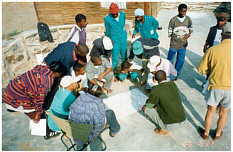
FIGURE 7-1 Paper maps used in decision support in Namibia (Source: Jo Tagg, Namibia Nature Foundation).
-
is aided by geographic information. Maps with icons (rather than words or numbers) are effective in over-coming communication challenges. And well-organized land-use plans attract potential investors who use maps of game distribution and land-use zones in their deliberations about the placement of tourist lodges that provide income and jobs for local people.
The program operates on a needs-driven approach, and promotes sharing of data and tools. Sharing has resulted in considerable cost savings, and is promoted by not charging for data; adopting standardized software, data formats, and file directory structure; and developing a metadata database. The needs-driven approach has built credibility with field users, led to a strong feeling of ownership by rural people and field-based support staff, fostered a culture of sensitivity to community needs among technical institutions that are partners in the program, generated trust and a common vision among partners (communities, government, donors), and built a critical mass to enhance sustainability of the program (Jo Tagg and Greg Stuart-Hill, Namibia Nature Foundation, personal communication, 2002).
IMPEDIMENTS TO IMPLEMENTING SPATIAL DECISION-SUPPORT SYSTEMS IN AFRICA
EIS-Africa (2001) concluded from a review of information initiatives in Ghana, Mozambique, Senegal, Uganda, and Zimbabwe that few application-oriented examples demonstrated advanced analysis of geographic information. Information systems were still insignificant in environmental decision-making. The following reasons were cited:
-
the decision-support process has not been planned, and clear objectives, goals, and responsibilities of local agencies have not been set;
-
projects are orientated toward data production and updating rather than usage or application (most organizations do not consider analysis to be part of their mission);
-
there is a focus on technical issues instead of data management in support of the decision-making process;
-
many databases are still under construction—hence many organizations have not had time to consider analysis;
-
poor communication between technical staff and those involved in environmental science;
-
lack of inclusion of universities in the environmental network in several of the countries (reducing the chance for ongoing research projects to be a driving force for analysis and data combination);
-
lack of demand and user awareness; and
-
difficulty measuring the impact of technological advances on the decision-making process.
The focus on developing data instead of the analytical environment for using data in the decision-making process partly results from limitations on data accessibility. However, there are also organizational barriers caused by a focus on applied analysis rather than basic research. Research investments have the potential to advance understanding of relationships that tie data together. For example the relationship between soil texture, slope, rain intensity, and other factors that determine soil erosion is embodied in the Universal Soil Loss Equation, which itself must be locally calibrated. This equation is a powerful analytical tool, and was an outcome of basic research. It remains to be tested and adapted for use in many parts of Africa.
Deploying a spatial decision-support system requires field research, case studies, and pilot projects. Development assistance investments targeted to research-based programs would promote a shift from descriptive to process-based analysis in spatial decision-support systems. There are some examples where these long-term investments can work. USAID’s Cooperative Research Support Program (Chapter 3) recognizes the importance of research to development assistance programs and has promoted collaborative research between U.S. land grant universities and African organizations, mostly in agriculture and natural resource management. With the increasing availability of geographic data and decision-support tools, there is an opportunity for these programs to emphasize the spatial aspects of the research.
OPPORTUNITIES FOR ENHANCING DECISION SUPPORT IN AFRICA
This section draws from lessons learned in examples from the previous sections and discusses approaches that could increase integration of decision-support systems into development policy-making and natural resources management.
The contribution of decision-support systems to policy dialog depends on geospatial capacity (Box 7-3 and Chapter 8) (e.g., good data and equipment and trained staff) and communication among policy-makers, scientists, GIS experts, and civil society (Bassolé, et al., 2001). These interactions are “most effective within a fully supportive geo-information policy environment at the national level” (Bassolé et al., 2001).
In addition to geospatial capacity, demand will spur the development and use of decision-support systems. In the committee’s opinion, the agricultural and natural resource management sectors are a likely primary source of this demand, as these sectors are the main users of geographic data and tools. The livelihoods of the majority of Africans depend on agriculture and natural resources, and pressing problems within these sectors include soil infertility and erosion, pollution from farm chemicals, pressure from grazing, and competition for resources. Addressing these problems demands better data and better ways of analyzing the relationship between human activities and changes on the land surface. Hence, decision support in the area of land cover (Chapter 6) will be one of the more fruitful application areas of geographic data and tools.
A further rationale for focusing on land cover is that it is basic information for many applications. Land use and cover change is at the nexus of a range of issues including habitat fragmentation, biodiversity, food and agriculture, water quality, urbanization and settlement, and human health and disease. Land cover is also readily obtained from satellites.
International activities could accelerate the use of decision-support systems for land-cover applications in Africa. For example, as the U.S. Geographic Information for Sustainable Development Alliance (GISD, 2002) initiatives are implemented, the need will arise to identify data for understanding land transformation processes. In addition, U.N. initiatives, notably the Global Land Cover Network and the GOFC/GOLD programs (Chapter 6), emphasize routine observations and analysis of land cover and change.
Strategies to improve or create these data sets are needed now, and these strategies should build on existing initiatives and networks. An effective land-cover decision-support system for Africa would include:
-
Development of standardized land cover and environmental classification systems. Classification systems are central to the use of the product layers in a spatial data infrastructure. Classification systems are defined and formalized but are not rigid. FAO’s Africover Land Cover Classification System (Chapter 6) is an emerging standard in Africa.
-
Development of a system for land-cover baseline and change detection across spatial scales. This component would include a baseline map and compilations of change maps from repeated observations over time. These maps can be constructed using multi-resolution remotely sensed data (e.g., AVHRR, MODIS, SPOT VEGETATION, ASTER [Annex Box 6-4], Landsat). Satellite observations alone cannot explain socio-economic and political factors that are among the causes of land-cover and environmental change, nor can they always identify trends or dynamics at the scale needed by decision-makers. Hence, remotely sensed data should be coupled with multi-scale geographically referenced economic and social data.
-
Identification of “hot spots” of change. Because resources are scarce, and there are limited opportunities for decision-makers to make comprehensive evaluations, an approach that identifies areas of rapid change, high risk, or other critical occurrences should be developed. The routine identification of such hot spots will guide decision-makers to critical locations and times for the most efficient use of resources (e.g., Figure 6-5).
-
Analysis and modeling of the relationship of land-cover change to proximate causes. Identification of
|
BOX 7-3 Based on case studies in Burkina Faso, Côte d’Ivoire, and the Gambia, Bassolé et al. (2001) made the following recommendations:
|
-
drivers of change enables decision-makers to make critical interventions. Human causes of immediate, or proximate, land-cover change include land-management strategies that convert land cover from one type to another (e.g., from forest to field). A better understanding could be developed of the links between human activities and consequences for land-cover change if it were possible to measure the magnitude, frequency, and geographic distribution of proximate causes. With GIS and other analysis tools it is possible to develop quantitative analyses of spatial relationships associated with land-cover change and their drivers.
-
Definition of important pressures and remedies through case studies and modeling. Direct observations of resource status alone do not reveal driving forces of land-cover and environmental change. If the drivers are unknown, natural resources management cannot be effective. Experience and knowledge for making policy decisions is gained by linking direct observations, case studies, and models to identify dominant drivers of environmental change. Linking observations at a range of spatial and temporal scales to empirical models that include socioeconomic activities and management goals allows a comprehensive, systematic approach to managing land-cover change.
-
Prediction of land-cover and environmental change risk zones. Once a spatial model of environmental change has been calibrated, a projection can be generated representing the probability of future land-cover changes. This projection can be overlain on a land-cover map corresponding to the current situation to highlight areas at risk of unwanted change. Land-cover change probability maps allow validation of the models because they can also be used in retrospect to compare the actual land-cover changes that took place between two past observation years used in the model’s calibration.
-
Development of environmental indicators. An environmental indicator is a phenomenon or statistic associated with a particular environmental condition. Indicators of land use and cover change, and quality can be used to assess trends over time and to determine the efficacy of policy actions. Such indicators can be developed from various observation sources. Remotely sensed data can indicate areas where change is occurring. For example, the occurrence of fires or change in the spectral properties of data, which provides an indi-
-
rect “alarm” that there has been some kind of land-cover change). Subsequently, detailed analysis can be done through ground observations.
The agricultural and natural resource management sectors are among the main users of geographic information making land cover a priority area for the development of spatial decision-support systems in Africa. A land-cover decision-support system should include a standard classification system; baseline data and change detection capabilities; hot spot detection and high risk zone prediction capabilities; analysis and modeling of proximate (mainly human) causes of change; linkages between direct observations, case studies, and models; and established environmental indicators.
SUMMARY
Management of natural resources and development in a sustainable manner is ultimately a process of evaluation and decision-making. Decision-making is a complex process that involves value judgments and analysis of a broad array of information. GIS is a decision-support tool that can be used to integrate many kinds of data into a usable format, analyze data, and produce descriptive and predictive modeling of alternative scenarios.
Many decision-makers in developed and developing countries have no experience with GIS and other spatial decision-support tools, and thus do not appreciate their potential. Additional impediments to implementation of spatial decision-support systems include the orientation of projects toward data production rather than application; lack of planning for the decision-support process; lack of communication between technicians and scientists within an organization; and lack of inclusion of university research that could drive data analysis. Nonetheless, there are demonstrations of the value of decision-support tools in the African context such as the continent-wide MARA and FEWS NET programs, the Miombo Network in southern Africa, the Livestock Early Warning System in East Africa, and the Community Based Natural Resources Management program in Namibia.
Presently, there is a limited commercial market for geographic information, services, and technologies in Africa, but the need for spatial decision-support systems and demand is likely to grow. The agricultural and natural resource management sectors are among the main users of geographic information making land cover a priority area for the development of spatial decision-support systems in Africa.
Human, societal, and organizational capacity is needed to integrate geographic information and spatial decision-support tools into the decision-making process. The next chapter discusses geospatial capacity building.
REFERENCES
Bassolé, A., J. Brunner, and D. B. Tunstall. 2001. GIS: Supporting Environmental Planning and Management in West Africa. Washington, D.C. : World Resources Institute.
Chopak, C. 2000. Early Warning Primer: and Overview of Monitoring and Reporting. Available at: <http://www.fews.net>. Accessed June 28, 2002.
Cowen, D. J. 1988. GIS versus CAD versus DBMS: What are the differences? Photogrammetric Engineering and Remote Sensing 54:1551-1554.
Daratech. 2001. GIS software revenue tops $939 million in 2000. Press Release. Cambridge, Massachusetts: Daratech Inc. Oct. 24, 2001.
Densham P. J. and M. F. Goodchild. 1989. Spatial Decision Support Systems: A Research Agenda. Pp 707-716 in Proceedings GIS/LIS’89, Orlando, FL. Bethesda, MD: ASPRS
Eastman, J. R. 1999. Multi-criteria evaluation and GIS. Pp 493-502 in Geographical Information Systems, P. A. Longley, M. F. Goodchild, D. J. Maguire, and D.W. Rhind, eds. New York: John Wiley and Sons.
Eastman, J. R. 2001a. Guide to GIS and Image Processing. Volume 2. Worcester, MA: Clark Labs.
Eastman, J. R. 2001b. Uncertainty Management in GIS: Decision Support Tools for Effective Use of Spatial Data. Pp 379-390 in Spatial Uncertainty in Ecology: Implications for Remote Sensing and GIS Applications, C. Hunsaker, M.F. Goodchild, M. Friedl, and E. Case, eds. New York: Springer-Verlag.
EIS-Africa (Environmental Information Systems-Africa). 2001. Environmental Information Systems Development in Sub-Saharan Africa: Approaches, Lessons and Challenges. E. Gavin and J. Gyamfi-Aidoo, eds. EIS-Africa.
FEWS NET (Famine Early Warning System Network). 2002. Homepage. Available at <http://www.fews.net>. Accessed June 28, 2002
GISD (Geographic Information for Sustainable Development). 2002. Geographic Information for Sustainable Development homepage. Available at <www.opengis.org/gisd>. Accessed May 15, 2002.
LEWS (Livestock Early Warning System). 2001. Available at <http://cnrit.tamu.edu/lews/description.html>. Accessed May 20, 2002.
Malczewski, J. 1997. Spatial Decision Support Systems, NCGIA Core Curriculum in GIScience. Available at <www.ncgia.ucsb.edu/giscc/units/u127/u127.html>. Accessed June 5, 2002.
NCGIA (National Center for Geographic Information Analysis). 1990. Research Initiative 6: Spatial Decision Support Systems. NCGIA Technical Paper 90-5. University of California, Santa Barbara, September 1990.
NCGIA. 1996. Report from the specialist meeting on collaborative spatial decision making, Initiative 17. National Center for Geographic Information Analysis, University of California, Santa Barbara, September 1995.
NRC (National Research Council). 1999a. Our Common Journey: A Transition Toward Sustainability. Washington, DC: National Academy Press.
NRC. 1999b. Distributed Geolibraries. Washington, DC: National Academy Press.
Schmidheiny, S. with the Business Council for Sustainable Development. 1998. Changing Course: A Global Business Perspective on Development and the Environment. Cambridge, MA: MIT Press.
Simon, H. A. 1977. The New Science of Management Decision. Englewood Cliffs, N.J.: Prentice-Hall.


