
2
Agenda 21 Implementation: Progress, Challenges, and the Role of Geographic Data
INTRODUCTION
This chapter provides an overview of the progress that has been made in implementing Agenda 21. Specifically, it examines national and local Agenda 21 activities, first for the world as a whole and then for African countries. The chapter looks broadly at what has been accomplished and discusses challenges to Agenda 21 implementation. Finally, the chapter summarizes the potential contribution of geographic data to achieving Agenda 21 objectives.
GLOBAL PROGRESS WITH IMPLEMENTATION OF AGENDA 21
The 1992 U.N. Conference on Environment and Development (UNCED) provided a political foundation and programs to facilitate the transition toward sustainable development (UNCED, 1992) (Table 1-1). Agenda 21 was accepted by more than 178 governments in 1992. Progress toward achieving Agenda 21 goals is occurring, but has been slower than anticipated (UN, 2002a). Efforts to integrate environment and development into a common sustainable development framework remain in the early stages (UN, 2002a). Meanwhile, environmental degradation and poverty at a global scale is worsening (Dernbach, 2002).
Three major trends characterize progress on Agenda 21 implementation over the last 10 years. First, the concept of sustainable development prompted a shift from focusing on single issues toward appreciating complex interactions between a wide range of environmental and developmental factors. This shift is part of what has been called “the transition to sustainability” (NRC, 1999). Second, there is a movement from international top-down norm-setting to national institution-building and more “grassroots” approaches at the local government level. Third, Agenda 21 demands place-based scientific and technical knowledge, which has resulted in increasing involvement of research-based institutions such as universities and private enterprises (Juma, 2002).
National Government Implementation of Agenda 21
At the present time at least 85 countries have developed national strategies for implementing Agenda 21 (UN, 2002a). Some common strategies include the development of the following:
-
thematic policies that articulate broad sustainable development objectives;
-
traditional master plans based on national planning cycles;
-
mechanisms for coordination with donors; and
-
strategies to address international obligations to integrate environmental considerations into thematic activities.
In a number of developing countries sustainable development principles have been introduced in existing national frameworks, such as conservation strategies, environmental plans, national vision statements, and national Agenda 21 initiatives (UN, 2002a).
Local Government Implementation of Agenda 21
The role of local governments is critical in educating, mobilizing, and responding to the public (Lake, 2000). Chapter 28 of Agenda 21 focuses on the local government role. The contents of that chapter provide the framework for the International Council for Local Environment Initiatives (ICLEI) (Box 2-1).
The U.N. undertook two surveys of Local Agenda 21 implementation. The first survey was in 1997, the second in 2001 (UN, 2002b). For the purposes of the surveys “Local Agenda 21,” or LA21, was defined as
|
BOX 2-1
SOURCES: <http://www.iclei.org/la21/igp/>, <http://www3.iclei.org/la21/ascn/ascnsum.htm>, <http://www.sustainable-cities.org/sub2.html>; <http://www.iclei.org/europe/suscam.htm>, and <http://www.iclei.org/la21/charters.htm>. |
a participatory, multi-stakeholder process to achieve the goals of Agenda 21 at the local level through the preparation and implementation of a long-term, strategic plan that addresses priority local sustainable development concerns. (UN, 2002b).
By the end of 2001 nearly 6,500 local governments in over 100 countries were involved in LA21 (Table 2-1). Of these local governments 44 percent had active programs and the remainder had committed to the process. In the four years between surveys the number of LA21 activities more than tripled (driven primarily by activities in Europe), and the number of participating countries nearly doubled. LA21 initiatives often have evolved at the local level in the absence of a national campaign. Indeed, 59 percent of the initiatives progressed without national-level impetus.
Progress can also be measured by an increase in the number of LA21 processes that have moved from the vision statement stage into the action planning stage—from 38 percent in 1997 to 61 percent in 2001 (Table 2-2). Most of these have focused on the environment (Figure 2-1). Prominent environmental issues addressed include air quality and water resources management (Table 2-3). Over the next three to five years the prominence of natural resources management issues will increase (Table 2-3).
TABLE 2-1 Number of Local Governments Involved in Local Agenda 21 Activities in December 2001, by Region
|
Region |
Number of Countries |
Number of Local Governments |
|
Africa |
28 |
151 |
|
Asia-Pacific |
17 |
674 |
|
Europe |
36 |
5,292 |
|
Latin America |
16 |
114 |
|
Middle East |
9 |
73 |
|
North America |
2 |
101 |
|
SOURCE: UN (2002b). |
||
Private Sector Implementation of Agenda 21
Companies, especially multinational corporations, dominate the transformation of natural resources into products and services. Increasingly they find it in their own interests to meet sustainable development goals. The World Business Council for Sustainable Development maintains a collection of case studies of the sustainability transition from a wide variety of firms (WBCSD, 2002). The private-sector re-
TABLE 2-2 Status of Local Agenda 21 Activities in 2001
|
LA21 Municipal Planning Documents |
Vision Statement |
Local Action Plan |
Sustainable Development Policy |
Monitoring Report |
|
Municipalities completing document |
52% |
61% |
39% |
34% |
|
Average year adopted |
1999 |
1999 |
1998 |
1999 |
|
Documents developed with stakeholder participation |
83% |
89% |
77% |
63% |
|
Level of community participationa |
Medium |
Medium |
Medium |
High |
|
Documents using indicators |
52% |
55% |
51% |
70% |
|
Average document time frameb |
4 years |
4 years |
2 years |
1 year |
|
aBased on ranking participation from 1 to 5. bThe average number of years for which the vision statement, local action plan, sustainable development policy, or monitoring report is valid. SOURCE: UN (2002b). |
||||
sponse includes technological innovation, implementation of eco-efficiency standards, adoption of social responsibility practices, adjustment of management approaches, and promotion of dialogue and partnerships (Box 2-2).
Global Challenges in Implementing Agenda 21
The goals of Agenda 21 have met with limited success (UN, 2002a). According to the U.N., challenges to the implementation of the Agenda 21 objectives are
-
a fragmented approach toward sustainable development that de-couples environment and development. The concept of sustainable development integrates environment and development in the long term (Box 1-1). The current fragmented approaches to sustainable development arise from policies and programs at national and international levels that often are short-term and inadequately merge environmental and developmental considerations (UN, 2002a).
-
a lack of integrated national policies and approaches in the areas of finance, trade, investment, technology, and sustainable development. Commonly, short-term considerations are placed above the long-term use of natural resources, and policies are often compartmentalized.
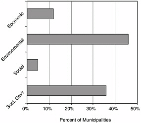
FIGURE 2-1 Focus of local Agenda 21 activities. Sust. Dev’t = Sustainable Development. SOURCE: Adapted from UN (2002b).
TABLE 2-3 Local Agenda 21 Activities Underway and Future Priority Issuesa
-
continuing unsustainable patterns of consumption and production that imperil natural life-support systems. Unsustainable consumption and production is rooted in value systems that drive how natural resources are used. Such value systems have proven slow to adapt.
-
inadequate financial resources and technology transfer from developed countries. Overseas development assistance has declined over the last decade, and debt burdens limit the opportunities of many developing countries to address sustainability issues. Additionally, private-sector investment has been volatile and focused on certain countries and sectors.
Challenges to implementation of Agenda 21 objectives have also been identified at the local level (UN, 2002b), and financial barriers are the largest impediment there. Other fac
|
BOX 2-2 Some private enterprises have demonstrated their commitment to sustainable development by signing on to the U.N. global compact that promotes sustainable growth and good citizenship through corporate leadership. The compact calls on enterprises to adopt nine universal principles in the areas of human rights, labor standards, and the environment. Several hundred companies from all over the world have pledged their support to the compact and are implementing the nine principles. In addition, enterprises are securing certification of environmental management systems under the ISO 14000 standard of the International Organization for Standardization or the European Eco-Management and Audit Scheme. Rising stakeholder participation has led to initiatives including the global reporting initiative, which is developing a common framework for voluntary reporting on the economic, environmental, and social aspects of organization-level activities, products, and services. SOURCE: UN (2002a). |
tors include lack of support from national governments, difficulties affecting change in the policy sector (lack of empowerment), difficulties in generating community interest, and insufficient expertise and information. The last of these challenges reflects the urgent need for capacity-building to strengthen decision-making on economic, social, and environmental development in an integrated, place-based manner.
Successful implementation of Agenda 21 entails two kinds of transition. First, there remains a need to convert international obligations into national policy.1 Second, this transition from normative standards to operational activities is usually associated with the creation of new knowledge (through scientific and technological research and the integration of indigenous or traditional knowledge) as part of a larger societal problem-solving process. Existing knowledge can also be applied in innovative ways. The need to reorient technology to respond to sustainability challenges was noted in Our Common Future.
First, the capacity for technological innovation needs to be greatly enhanced in developing countries so that they can respond more effectively to the challenges of sustainable development. Second, the orientation of technology development must be changed to pay greater attention to environmental factors (WCED, 1987).
The relationship between environment and development means that sustainable development requires scientific input to decision-making as well as the application of technologies. Since 1992, science has been central to addressing Agenda 21 challenges in such areas as climate change, global warming, ozone depletion, water purity, land integrity, and air quality.
IMPLEMENTING AGENDA 21 IN AFRICA
Efforts to implement Agenda 21 occur at continental, regional, national, and local levels. At the continental level the most ambitious activity is the establishment of the African Union, successor to the Organization of African Unity set up in 1963. Established in 2001, the African Union aims to enhance economic, political, and social integration and development of Africa; promote democracy; and resolve conflicts (NEPAD, 2001). To date, 37 of Africa’s 53 countries have joined the union. Currently, the African Union is strengthening 14 regional integration communities to transform them into building blocks for economic coordination in Africa.
Africa’s sustainable development aspirations are also reflected in continent-wide strategies of the New Partnership for Africa’s Development (NEPAD, 2001). The NEPAD is a pledge by African leaders to develop natural and human re-
sources. It recognizes that sustainability cannot be achieved until poverty is reduced, and living conditions are improved for the majority of the population. The NEPAD outlines the responsibility of African leaders to articulate national and regional priorities and to manage development by engaging people in their own development.
The Southern African Development Community (SADC), an intergovernmental group of 14 countries, is one example of a regional organization committed to equitable economic integration and sustainable development (Figure 2-2). In 2001 SADC completed an assessment of the regional implementation of Agenda 21 (SADC, 2001). Key issues addressed in the report are
-
Land resources. Land-tenure issues, diminishing grazing lands, and land degradation have hindered progress on Agenda 21 implementation. However, several SADC countries have developed environmental management programs aimed at protecting and rehabilitating land resources.
-
Forest resources. Rapid population growth and increased demand for food and energy resources are depleting forests. Groups have been organized to promote sustainable forestry management.
-
Water Resources. Recurrent droughts, increasing water demands, and water pollution impede the imple
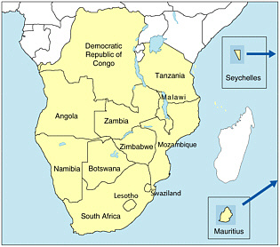
FIGURE 2-2 Map of the SADC member countries.
-
mentation of Agenda 21. SADC water resources ministers have adopted a regional approach to integrate water resources development and management. This initiative has prevented conflicts over shared waters and improved access to potable water. SADC countries have also implemented reforms aimed at sustainable management of water resources.
-
Coastal zone. Tourism and population pressure in coastal areas have thwarted implementation of Agenda 21. Critical to future implementation will be technology transfer, access to research findings and other information, and capacity-building for policy, institutional, and regulatory frameworks.
The Comité Permanent Inter-États de Lutte Contre la Sécheresse dans le Sahel (CILSS), an intergovernmental institution covering nine West African countries,2 is a second regional organization concerned with sustainable development. CILSS has launched the Sahel 21 initiative that encourages Sahelians to define the future of development in their region.
Most countries in sub-Saharan Africa have encountered difficulties in gathering and analyzing national and sub-na-
tional data on major Agenda 21 issues, such as natural resources inventories, climate change, and desertification. Thus, national-level reporting on these matters is uneven.
At the national level only South Africa has formally adopted a national Agenda 21 strategy (UN, 2002b). Although Burkina Faso, Cameroon, Cote d’Ivoire, and Ghana have not formalized national plans (NCSD, 2002), they have implemented national policies and laws that address issues related to sustainable development. For example, laws have been promulgated on environmental impact assessment; sustainable use of water, forests, and biodiversity; and management of solid wastes. In addition, over 95 percent of African countries have ratified the Rio conventions—the Convention on Biological Diversity, the U.N. Framework Convention on Climate Change, and the U.N. Convention to Combat Desertification (UNEP, 2001). At the local level there are LA21 activities in 28 African countries (Table 2-4).
African leaders discussed the challenges of implementing Agenda 21 at three regional consultations of the Rio+5 Forum3: North Africa and the Middle East (1996), West and Central Africa (1996), and South and East Africa (1997). The following challenges were identified at the consultations (Dorm-Adzobu, 2002):
-
Inappropriate institutional frameworks in most countries, particularly a lack of coordination among ministries and across sectors;
-
Inadequate coordination between governments, NGOs, and the private sector;
-
Lack of appropriate legal frameworks;
-
Lack of national consultation prior to signing international agreements and the proliferation of those agreements, which results in signing conventions without full knowledge of the implications to the countries and without having the capacity to translate these agreements into action;
-
Poverty, illiteracy, and lack of awareness create problems in the development and implementation of sustainable development programs;
-
Increasing gap between population growth and national economic output;
-
Marginalization of women in the national development process; and
-
Lack of vision and commitment by leaders to implement sustainable development.
Several documents (NEPAD, 2001; UNEP, 1999, 2001) provide detailed information on such topics as living conditions, national debt, armed conflicts, human health, environ
TABLE 2-4 African Countries with Local Agenda 21 Activities
|
Country |
Number of LA21 Initiatives |
|
Algeria |
3 |
|
Benin |
1 |
|
Burundi |
2 |
|
Cameroon |
1 |
|
Congo, Democratic Republic of |
2 |
|
Egypt |
7 |
|
Gabon |
1 |
|
Ghana |
3 |
|
Kenya |
11 |
|
Libya |
2 |
|
Madagascar |
5 |
|
Mali |
2 |
|
Malawi |
4 |
|
Mauritania |
1 |
|
Morocco |
5 |
|
Mozambique |
2 |
|
Namibia |
5 |
|
Nigeria |
5 |
|
Rwanda |
1 |
|
Senegal |
3 |
|
South Africa |
20 |
|
Sudan |
1 |
|
Tanzania |
13 |
|
Togo |
2 |
|
Tunisia |
1 |
|
Uganda |
5 |
|
Zambia |
4 |
|
Zimbabwe |
39 |
|
SOURCE: UN(2002b). |
|
ment, and education, giving a broad sense of environmental and developmental challenges facing African countries.
In summary, most of the progress in African countries toward implementation of Agenda 21 has been at the normative rather than the operational level, with the emergence of coordinating organizations such as SADC. In addition, national policies and laws relating to environment and development have been agreed upon and international environmental treaties have been signed by the majority of African countries. Effective translation of these measures into operational programs will require increased use of geographic information in decision-making (ECA, 2001). The integrative nature of GIS lends itself to a unified approach as opposed to the traditional fragmented approach to sustainable development (UN, 2002a). Application of GIS exemplifies the reorientation of technology in responding to sustainability challenges (WCED, 1987).
THE ROLE OF GEOGRAPHIC INFORMATION IN MEETING AGENDA 21 OBJECTIVES
The implementation of Agenda 21 has been slow (UN, 2002a) but the collection, analysis, and use of geographic information offers a starting point on the path to sustainable
development (Brooner, 2002). Society can benefit from the capabilities of geographic and other information sources and systems.4 The NEPAD recognizes the value of these data and technologies: “[Information and Communications Technologies (ICTs)] can be helpful tools for a wide range of applications, such as remote sensing and environmental, agricultural, and infrastructural planning. In conflict management and control of pandemic diseases, ICTs will help towards the organization of efficient early warning mechanisms by providing tools for constant monitoring of tension spots (NEPAD, 2001).” In addition, the United Nations (2002a) notes the value of satellite remote-sensing systems as data sources for supporting sustainable development (Box 2-3).
Geographic data and information have the potential to play a role in the planning, implementation, and monitoring of many of Agenda 21’s 38 action items (Table 1-1). In the committee’s opinion these data and information are directly applicable to at least 20 of these action items (Table 2-5). These geographic data are often grouped into framework foundation data, framework thematic data, and other thematic data. Framework foundation data, such as geographic position and elevation, are central to most applications, whereas framework thematic data and other thematic data have specific applications, such as determining land ownership, possession, or use (Chapters 4, 5, and 6).
TABLE 2-5 Selected Agenda 21 Action Items (numbered by chapter from Agenda 21) and the Geographic Data to Address Them
|
|
Framework Foundation Data (Fundamental layers of data used in many basic operations [Chapters 4 and 5]) |
|||
|
Agenda 21 Action Items |
Position (Geodetic Controla) |
Aerial Image (Orthoimageryb) |
Digital Elevation (Topography) |
|
|
3. |
Combating poverty |
✓ |
✓ |
✓ |
|
4. |
Changing consumption patterns |
✓ |
✓ |
✓ |
|
5. |
Demographic dynamics and sustainability |
✓ |
✓ |
✓ |
|
6. |
Protecting and promoting human health |
✓ |
✓ |
✓ |
|
7. |
Sustainable human settlement development |
✓ |
✓ |
✓ |
|
8. |
Integrating environment and development in decision-making |
✓ |
✓ |
✓ |
|
9. |
Protecting the atmosphere |
|
|
✓ |
|
10. |
Integrated planning and management of land resources |
✓ |
✓ |
✓ |
|
11. |
Combating deforestation |
✓ |
✓ |
✓ |
|
12. |
Managing fragile ecosystems: combating desertification and drought |
✓ |
✓ |
✓ |
|
13. |
Managing fragile ecosystems: sustainable mountain development |
✓ |
✓ |
✓ |
|
14. |
Promoting sustainable agriculture and rural development |
✓ |
✓ |
✓ |
|
15. |
Conservation of biological diversity |
✓ |
✓ |
✓ |
|
16. |
Environmentally sound management of biotechnology (DNA) |
|
||
|
17. |
Protecting oceans, seas, coastal areas, and rational use and development of living resources |
✓ bathymetry |
✓ |
✓ coastal |
|
18. |
Protecting the quality and supply of freshwater resources |
✓ |
✓ |
✓ |
|
19. |
Environmentally sound management of toxic chemicals |
✓ |
✓ |
✓ |
|
20. |
Environmentally sound management of hazardous wastes |
✓ |
✓ |
✓ |
|
21. |
Environmentally sound management of solid waste and sewage-related issues |
✓ |
✓ |
✓ |
|
22. |
Environmentally sound management of radioactive wastes |
✓ |
✓ |
✓ |
|
aGeodetic control is the common reference system for establishing the coordinate position (e.g., latitude, longitude, and elevation) of geographic data. bAn ortho-image is a specially processed image prepared from an aerial photograph or remotely sensed image that has the metric qualities of a traditional line map with the rich detail of an aerial image. Temp = temperature; atmo = data on atmospheric conditions; precip = precipitation. |
||||
Agenda 21 (UNCED, 1992) specifies needs with respect to geographic data and information, and related technologies, including
-
global sustainability indicators;
-
data collection and use, including satellite-based remote-sensing;
-
data assessment and analysis; and
-
geographic information systems.
Additionally, Agenda 21 expressed the need for modern information frameworks and improved standards and methods for handling information, documentation about information, electronic networking capabilities, and partnerships among governments, international organizations, and the private sector. Many of these issues are fundamental to spatial data infrastructures (NRC, 1993; ECA, 2001; see also Chapter 4) that permit multisectoral, international, and transboundary data use and sharing. However, the data foundation on which this infrastructure can be built is far from complete or accessible to those that need it (Chapter 1), and the benefits of geographic data for decision-making on Agenda 21 issues have not been fully realized (ECA, 2001).
AN APPROACH TO EVALUATING THE ROLE OF GEOGRAPHIC INFORMATION IN SUSTAINABLE DEVELOPMENT APPLICATIONS
More than one approach can be taken to evaluate the use of geographic information for sustainable natural resource management and development in African countries and
|
|
Selected Thematic Data (Supplemental layers of data that are often overlaid onto framework foundation data [Chapters 4, 5, and 6]) |
|||||||||
|
Human (Total, Population Distribution, Change) |
Land Ownership/ Possession (Cadastre) |
Land Use/Land Cover |
Biophysical Data (for Environmental Monitoring) |
|||||||
|
Local Scale |
Regional Scale |
Global Scale |
Vegetation |
Temp |
Moisture Content |
Precip |
Water Quality |
Atmo |
||
|
✓ |
✓ |
✓ |
✓ |
✓ |
✓ |
|
✓ |
|
||
|
✓ |
✓ |
✓ |
✓ |
✓ |
✓ |
|
||||
|
✓ |
✓ |
✓ |
✓ |
✓ |
✓ |
|
✓ |
|
||
|
✓ |
✓ |
✓ |
✓ |
✓ |
✓ |
|
✓ |
✓ |
||
|
✓ |
✓ |
✓ |
✓ |
✓ |
✓ |
|
✓ |
✓ |
✓ |
|
|
✓ |
✓ |
✓ |
✓ |
✓ |
✓ |
|
✓ |
✓ |
✓ |
✓ |
|
✓ |
✓ |
✓ |
✓ |
✓ |
✓ |
✓ |
✓ |
✓ |
✓ |
✓ |
|
✓ |
✓ |
✓ |
✓ |
✓ |
✓ |
|
✓ |
✓ |
✓ |
✓ |
|
✓ |
✓ |
✓ |
✓ |
✓ |
✓ |
✓ |
✓ |
✓ |
✓ |
✓ |
|
✓ |
✓ |
✓ |
✓ |
✓ |
✓ |
✓ |
✓ |
✓ |
✓ |
✓ |
|
✓ |
✓ |
✓ |
✓ |
✓ |
✓ |
✓ |
✓ |
✓ |
✓ |
✓ |
|
✓ |
✓ |
✓ |
✓ |
✓ |
✓ |
✓ |
✓ |
✓ |
✓ |
✓ |
|
✓ |
✓ |
✓ |
✓ |
✓ |
✓ |
✓ |
✓ |
✓ |
✓ |
✓ |
|
✓ |
|
✓ |
✓ |
|
✓ |
|
|
|
✓ |
|
|
✓ |
✓ |
✓ |
✓ coastal, oceanic |
✓ |
✓ |
✓ |
✓ |
✓ |
✓ |
✓ |
|
✓ |
✓ |
✓ |
✓ |
✓ |
✓ |
|
✓ |
✓ |
✓ |
✓ |
|
✓ |
✓ |
✓ |
✓ |
|
✓ |
✓ |
✓ |
✓ |
✓ |
✓ |
|
✓ |
✓ |
✓ |
✓ |
|
✓ |
✓ |
✓ |
✓ |
✓ |
✓ |
|
✓ |
✓ |
✓ |
✓ |
|
✓ |
✓ |
✓ |
✓ |
✓ |
✓ |
|
✓ |
✓ |
✓ |
✓ |
|
✓ |
|
|
|
✓ |
✓ |
|
BOX 2-3 Earth observation from space is a valuable technological tool for understanding Earth. Such observations have provided long-term, consistent measurements of key variables for studying the state and variability of Earth’s ecosystems. These observations provide a basis for rational action at global, regional, national, and local levels. Global phenomena, such as the greenhouse effect and El Niño, jostle for attention with regional problems, such as acid rain, and local problems, such as deforestation and soil erosion. Satellite remote-sensing has provided vital information on the environmental impacts, quantity and quality of resources, and inputs for integrated development planning for rural and urban areas. The launching of more than 230 instruments on more than 70 satellites over the next 10 to 15 years, with calibrated sensors providing a wide variety of data, will provide an opportunity for scientists to understand the complex interactions among various components of the Earth system. Parts of the world without the infrastructure to connect to the new global and information communication networks and people without access to education in the new technologies are being left behind. SOURCE: UN (2002a, paragraph 162). |
elsewhere. For example, in an issue-based approach each of the major natural resource or development applications is viewed separately. Major topics might include combating deforestation, conservation of biological diversity, health management, vulnerability to natural disasters, and combating poverty (e.g., Tables 1-1 and 2-5). However, most applications, especially those associated with natural resources, require approximately the same geographic information (e.g., a common coordinate system, elevation distribution, hydrologic data, land use or cover, political boundaries, transportation networks, population distribution), often collected multiple times to monitor change and evaluate impacts. Thus, the fundamental geographic information requirements repeatedly manifest themselves when marching through the issue applications (e.g., Table 2-5). Unfortunately, many developing countries lack the fundamental information for these applications.
Consequently, in order for developing countries in Africa and elsewhere to use geographic information to address sustainable development issues it is critical that (a) the importance of certain fundamental framework geographic information datasets is recognized, and (b) the current status and likely future availability of this geographic information is identified. This committee is not alone in recognizing the need for fundamental (or framework) geographic information for multiple applications. Many countries agree on the value of collecting and organizing certain geographic information within the structure of a national spatial data infrastructure (NRC, 1995, 2001; FGDC, 1997, 2002; ECA, 2001) (Chapter 4). The geographic information for a country may also be used to address global problems by adhering to Global Spatial Data Infrastructure protocols (GSDI, 2002). Once these most important geographic information layers are available they may be used many times for many different applications, ideally within rigorous decision-support systems. Thus, these data become an important national and international asset (ECA, 2001) and are the baseline for future analyses and assessments.
The following comparison demonstrates why the committee focused on assessing the major types of geographic information required by many applications rather than adopting an issue-by-issue approach. Consider the problem of famine. To predict famine and make plans to minimize its impact on humans it is useful to have information on land cover (including crop type, biomass, and leaf-area-index), precipitation (recent and predicted), soil moisture (recent and predicted), population distribution, transportation infrastructure (to deliver food relief or relocate people), and political boundaries (to help address politically sensitive issues). These types of data are used in famine decision-support systems such as the Famine Early Warning System (Chapters 3 and 7).
Similarly, consider deforestation and biodiversity assessment (e.g., Box 2-4). Both issue applications require information including population distribution (to identify the likelihood for forest-cover or biodiversity changes due to selective harvesting of forest resources or other agricultural practices), land use and cadastral information, land cover (to reveal the historical and current geographic distribution of rangeland or forest cover, in part as a surrogate for habitat in biodiversity applications), elevation distribution (to provide insight into watershed runoff, soil erosion, and habitat carrying capacity), and transportation infrastructure (to indicate new tertiary roads that provide access to forests and enable deforestation and habitat fragmentation). When these types of geographic information are modeled in conjunction with in situ faunal information it becomes possible to assess biodiversity (Savitsky and Lacher, 1998). Subsequently, biodiversity information can be used to perform “gap analysis” for wise use of financial resources to protect fragile, biologically diverse habitats (Edwards et al., 1995).
It is evident from the overlap in data needs to address biodiversity, deforestation, and famine that the same fundamental geographic information may be used in more than one issue application. Thus, this report concentrates on fundamental geographic data (Chapters 5 and 6) that provide
|
BOX 2-4 Biodiversity is the biological diversity in an environment as indicated by numbers of different species of plants and animals (Merriam-Webster, 1994). People everywhere depend on functioning natural ecosystems for their survival. Population growth, the clearing of wildlands, and overuse of pesticides and fertilizers are among the principal causes of loss of biodiversity in developing countries (Wilson, 1992). Poverty, social conflict, and disease are among the results of environmental despoliation. The economic and social benefits of biodiversity range from discovering new sources of pharmaceuticals to enhancing tourism. Coastal areas in Kenya and Tanzania (Chapter 8) gain economically from aquaculture, tourism, and disaster protection. Conservancies in Namibia also benefit through tourism. Their use of geographic information for wildlife management (Chapter 7) promotes equitable land use and tourism potential. Geographic information can be used to support African governments’ efforts to monitor the state of natural resources for environmental protection, hazard reduction, and for international environmental reporting required by treaties such as the Convention on Biological Diversity and the Convention on International Trade in Endangered Species of which many African countries are signatories. The Eastern and Southern Africa Regional Biodiversity Forum convened representatives from the public, private, and non-profit sectors in Mombasa, Kenya, in 2000 to discuss using biodiversity to strengthen livelihoods (Emerton and Maganya, 2000). Representatives from more than 20 countries identified four major conclusions:
SOURCE: Emerton and Maganya (2000) |
the geographic foundation for many Agenda 21 issues and on the decision-support systems and capacity-building efforts needed to link these data to their applications.
SUMMARY
Agenda 21 is being implemented worldwide at all scales and in all sectors, but progress has not been as rapid as anticipated at the UNCED in 1992. The use of geographic data and related technologies will help overcome a number of implementation challenges, in particular the traditional fragmented approach toward sustainable development. In Africa, organizational frameworks and coordination will enhance the use of these data and technologies. The next chapter illustrates activities in Africa that are already using geographic data.
REFERENCES
Brooner, W. G. 2002. Promoting Sustainable Development with Advanced Geospatial Technologies. Photogrammetric Engineering and Remote Sensing 68(3):198-205.
Dernbach, J. C., 2002. Sustainable Development: Now More Than Ever. Environmental Law Reporter 32 (1):10003-10019.
Dorm-Adzobu, C., compiler. 2002. Synthesis Report of Africa and the Middle East Consultations on Implementation of Sustainable Development. Available at <http://www.ecouncil.ac.cr/rio/regional/africa/afmesynt.htm>. Accessed June 25, 2002.
ECA (United Nations Economic Commission on Africa). 2001. The Future Orientation of Geoinformation Activities in Africa: A Position Paper. Available at <http://www.uneca.org/eca_programmes/it_for_development/geoinfo/FutureGIAfrica.PDF>. Accessed June 25, 2002.
Edwards, T. C., C.G. Homer, S.C. Bassett, A. Falconer, R.D. Ramsey, and D. W. Wighe. 1995. Utah Gap Analysis: An Environmental Information System. Logan, Utah: Utah Cooperative Fish and Wildlife Research Unit.
Emerton, L. and J. Maganya (eds.). 2000. Report of the First Eastern and Southern Africa Regional Biodiversity Forum: Using Biodiversity to Strengthen Livelihoods. Mombasa, Kenya: IUCN – The World Conservation Union, East Africa Regional Office, Nairobi. Available at <http://www.undp.org/bpsp/regional/docs/E_S_Africa_RBF_Feb2000.pdf>. Accessed July 8, 2002.
FGDC (Federal Geographic Data Committee). 1997. Framework: Introduction and Guide, Washington, DC: Federal Geographic Data Committee.
FGDC. 2002. Overview: What the Framework Approach Involves. Available at <http://www.fgdc.gov/framework/overview.html>. Accessed April 24, 2002.
GSDI (Global Spatial Data Infrastructure). 2002. Developing Spatial Data Infrastructure: The SDI Cookbook. D. Nebert, ed. Available at <http://www.gsdi.org/pubs/cookbook/cookbook0515.pdf >. Accessed June 28, 2002.
Juma, C. 2002. The global sustainability challenge: from agreement to action. International Journal of Environmental Issues 2(1/2):1-14.
Lake, R.W. 2000. Contradictions at the local scale: local implementation of Agenda 21 in the USA. Pp. 70-90 in Consuming Cities: The Urban Environment in the Global Economy after the Rio Declaration, N. Low, B. Bleeson, I. Elander, and R. Lidskog, eds. London: Routledge.
Merriam-Webster. 1994. Merriam-Webster Pocket Dictionary. MerriamWebster: Springfield, MA.
NCSD (National Councils for Sustainable Development). 2002. NCSD Knowledge Network. Available at <http://www.ncsdnetwork.org/ncsd/main.cfm>. Accessed May 20, 2002.
NEPAD (New Partnership for Africa’s Development). 2001. The New Partnership for Africa’s Development. Available at <http://www.dfa.gov.za/events/nepad.pdf>. Accessed May 29, 2002.
NRC (National Research Council). 1993. Toward a Coordinated Spatial Data Infrastructure for the Nation. Washington, DC: National Academy Press.
NRC. 1995. A Data Foundation for the National Spatial Data Infrastructure. Washington, DC: National Academy Press.
NRC. 1999. Our Common Journey: A Transition Toward Sustainability. Washington, DC: National Academy Press.
NRC. 2001. National Spatial Data Infrastructure Partnership Programs: Rethinking the Focus. Washington, DC: National Academy Press.
SADC (Southern African Development Community). 2001. SADC Progress Report on the Implementation of Agenda 21 and Sustainable Development: A Report Submitted to the 2002 World Summit on Sustainable Development. Available at <http://www.johannesburgsummit.org/web_pages/sadc_prepcom_progress_report.pdf>. Accessed May 20, 2002.
Savitsky, B. G. and T. E. Lacher, Jr. 1998. GIS Methodologies for Developing Conservation Strategies. New York: Columbia University Press.
UN (United Nations). 2002a. U.N.’s Rio Plus 10 Review from Prepcom2. Available at <http://www.johannesburgsummit.org/html/documents/no170793sgreport.pdf>. Accessed May 29, 2002.
UN. 2002b. Second Local Agenda 21 Survey, UN Department of Social and Economic Affairs, background paper No. 15 (DESA/DSD/PC2/ BP15). Available at <http://www.iclei.org/rioplustenfinal_document.pdf>. Accessed April 14, 2002.
UNCED (United Nations Conference on Environment and Development). 1992. Report of the United Nations Conference on Environment and Development, Rio de Janeiro, 3-14 June 1992. Rio de Janeiro: UN. (Annex I: Rio Declaration; Annex II: Agenda 21)
UNEP (United Nations Environment Programme). 1999. Global Environmental Outlook 2000. London: Earthscan.
UNEP. 2001. Assessment of Progress on Sustainable Development in Africa Since Rio (1992). Available at <http://www.ecs.co.sz/wssd/roa_assessment_of_progress.htm>. Accessed June 25, 2002.
WBCSD (World Business Council for Sustainable Development) website. 2002. Case studies. Available at <http://www.wbcsd.org/casestud/index.htm>. Accessed May 20, 2002.
WCED (World Commission on Environment and Development). 1987. Our Common Future. New York: Oxford University Press.
Wilson, E. O. 1992. The Diversity of Life. New York: W.W. Norton and Company.


