
3
Geographic Information Activities in Africa
INTRODUCTION
Africa has a small but growing community of data providers, data processors and analysts, trainers, technicians, data and information users (decision-makers at many levels), and advocates. The community is becoming increasingly coordinated, and consists of Africans and international partners from non-governmental organizations, universities, private companies, and foreign governments including the space and aid agencies that currently are a major source of geographic data, information, training, and support.
This chapter introduces some geographic information activities in Africa and highlights the applications in tables. It focuses on activities in regions of Africa targeted by the U.S. government’s public-private partnership called Geographic Information for Sustainable Development (GISD). These regions are the Upper Niger basin in West Africa, the Limpopo-Zambezi region of southeastern Africa, and two in East Africa (the African Great Lakes region and the Kenya/ Tanzania coastal zone) (Figure 3-1). The chapter presents examples of ongoing activities and enumerates the range of applications rather than evaluating individual activities.
ORGANIZATIONS WITH CONTINENT-WIDE ACTIVITIES
This section describes five organizations with continentwide activities that utilize or promote collection and analysis of geographic data. These are
-
the Famine Early Warning System Network (FEWS NET),
-
U. N. Economic Commission for Africa (ECA),
-
U. N. Food and Agriculture Organization (FAO),
-
Environmental Information Systems-Africa (EIS-Africa), and
-
the Collaborative Research Support Programs (CRSP).
Famine Early Warning System Network
FEWS NET (Chapters 6 and 7) was initiated by the U.S. Agency for International Development (USAID) in 1980. This activity uses satellite imagery1 to provide an estimate of the amount and vigor of vegetation across Africa. FEWS NET is the principal food security information-based approach to preparedness and planning in sub-Saharan Africa, and aims to empower Africans to find solutions to food insecurity problems (FEWS NET, 2002).
Seventeen African countries participate in the FEWS NET.2 The network is supported by implementation partners3 and network partners (Centre Regional AGRHYMET4 [Niamey, Niger], Drought Monitoring Centre [Nairobi, Kenya], and SADC Regional Early Warning Unit [Harare, Zimbabwe]), which provide imagery, analyses, and reports on vegetation conditions.
Economic Commission for Africa
ECA promotes the use of geographic information in Africa. Resources developed by ECA include the Inventory of Education and Training Facilities in African GIS, the Cartographic Inventory Atlas for Africa, and the Database on the Status of Cartographic Coverage and Programs in Africa. ECA supports regional Centers (e.g., Nairobi) through its
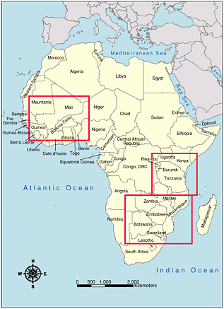
FIGURE 3-1 Case-study regions in Africa: the Upper Niger basin in West Africa, the Limpopo-Zambezi region of southeastern Africa, and two in East Africa (the African Great Lakes region and the Kenya/Tanzania coastal zone). SOURCE: Dan Zimble, ESRI.
geographic information activities at ECA headquarters in Addis Ababa. Harnessing Information for Development is one of six core programs of ECA, and geographic information is a part of the Development Information Services Division (DISD). In addition to supporting the regional centers and the five other core program areas of ECA, DISD activities include advisory services, developing inventories and databases, and organizing conferences and meetings. Since 1963 the ECA has organized a number of U.N. Cartographic Conferences, which in 1999 became part of the activities of the Committee on Development Information (CODI). This committee provides policy and technical guidance for the implementation of the core program on information for development, and these recommendations are passed on to the Conference of African Ministers of Planning and Development.
Food and Agriculture Organization
In 1995, the FAO initiated the Africover project (Chapter 6) in response to national requests for assistance in obtaining reliable, geographically referenced information on natural resources for use in early warning systems, forest and rangeland monitoring, catchment management, and biodiversity
or climate-change studies at national and regional levels. Ten countries of the eastern African sub-region5 are involved in the first application of this initiative. These countries are creating a digital geographically referenced land-cover database, the Multipurpose Africover Database for Environmental Resources (FAO, 2002). Funding for the project is from the Italian and U.S. governments.
Environment Information Systems-Africa
With goals similar to ECA, EIS-Africa (Chapter 4) is a network of public- and private-sector institutions and experts. Founded in 1999, it promotes “access to and use of environmental information in the sustainable development process.”6 EIS-Africa, currently with 24 member states, is the outgrowth of an earlier EIS project. The organization has many activities, including a bi-annual conference series called Africa GIS.7 The most recent Africa GIS conference in Nairobi, Kenya, in November of 2001 attracted 450 attendees, the largest number to date.8 EIS-Africa is a nonprofit pan-African organization funded and supported by several donors and international development agencies, including the World Bank, the Government of Norway, USAID, German Agency for Technical Cooperation, and several U.N. agencies including the U.N. Development Program (UNDP), and the U.N. Environment Program (UNEP).
Collaborative Research Support Programs
CRSPs promote agricultural research within Africa and elsewhere (Chapter 7). Created by USAID and the Board for International Food and Agriculture Development in 1975, CRSPs employ U.S. land grant universities to carry out the international food and agricultural research mandate of the U.S. government. CRSPs consist of universities working with developing-country national agricultural research systems, international agricultural research centers, U.S. agribusiness, private voluntary organizations, developing-country colleges and universities, private agencies, USAID/ Washington and USAID missions, and other U.S. federal agencies such as the U.S. Department of Agriculture (CRSP, 2002). Presently, there are nine CRSPs, and all of them have activities in Africa (Table 3-1).
GEOGRAPHIC INFORMATION ACTIVITIES IN CASESTUDY REGIONS
West Africa
The diverse populations of the Upper Niger River region (which includes the Sahelian ecological zone) (Figure 3-1) depend on the natural resources of the region’s arid ecosystems. Declines in land productivity, owing in part to desertification and climate change, have increased the vulnerability of people to food insecurity, especially over the last three decades (GISD, 2001). Table 3-2 provides a sample of some of the organizations that are using geographic data to address the region’s environmental challenges.
Featured Activities
Among the prominent, internationally supported centers in the region is AGRHYMET in Niamey, Niger. AGRHYMET uses remotely sensed data and maps to address natural resource management and food security issues for the nine West African member states of the Permanent Interstate Committee to Combat Drought in the Sahel/ Comité Permanent Inter-′Etats de Lutte Contre la Sécheresse dans le Sahel (CILSS).9 AGRHYMET is a focal point for FEWS NET activities (Chapter 6) and is a center of training and educational outreach in West Africa. Established in 1974, the center received financial assistance initially from USAID and later from Belgium, Denmark, France, and Italy, the Netherlands, and the World Meteorological Organization.
The Centre of Applied Research in Population and Development (CERPOD) (Chapter 5) is part of the Institute of the Sahel in Bamako, Mali. CERPOD concentrates on research and applied issues relating to population and development. In its work CERPOD integrates socioeconomic data with environmental data. Member countries from CILSS provide partial support for CERPOD, in addition to USAID, Canadian International Development Agency, and the U.N. Population Fund.
East Africa
In East Africa (Figure 3-1) food insecurity is a long-standing chronic issue (LEWS, 2001). Factors that have led to this situation include the region’s weather and climate variation, increasing human population, political instability, and land-use/cover changes. Indeed, in the late 1980s, an estimated 71 million people, or 46 per cent of the population in the Greater Horn of Africa, were reported to be chronically food insecure (LEWS, 2001).
In addition to food insecurity, the Great Lakes of East
TABLE 3-1 A Summary of Applications of Geographic Data by Collaborative Research Support Programs (CRSPs)
|
Name of CRSP, Year Established, Website |
Participating African Nations |
Applications of Geographic Data |
|
International Corn and Millet (INTSORMIL), 1979 |
Burkina Faso, Chad, Ghana, Mali, Niger, Nigeria, Senegal |
Soil and rainfall monitoring; tracking population and crop density to ensure proper food distribution, educating farmers to increase production |
|
Bean/Cowpea, 1980 <http://eastafricacrsp.wsu.edu/> |
Egypt, Jordan, Malawi, Nigeria, Senegal, Tanzania, Zimbabwe |
Drought, insect, and disease monitoring to improve crop yields |
|
Peanut, 1982 |
Angola, Benin, Botswana, Burkina Faso, Ghana, Senegal, Malawi |
Simulation of crop systems to improve production efficiency and natural resource management; monitoring nitrogen levels in soil |
|
Global Livestock, 1978 |
Eritrea, Ethiopia, Kenya, Tanzania, Uganda, |
Livestock monitoring; monitoring the effects of production on the environment; natural resource conservation and management |
|
Pond Dynamics/Aquaculture (PD/A), 1982 |
Egypt, Kenya, Rwanda |
Identification and monitoring of constraints to aquaculture; tracking physical, chemical, and biological processes of aquatic ecosystems |
|
Integrated Pest Management (IPM), 1993 |
Ethiopia, Ghana, Kenya, Mali, Senegal, Uganda, Zimbabwe |
Research and education programs to manage plant diseases and pests; development of Africa IPM Link for information exchange and electronic communication |
|
Sustainable Agriculture and Natural Resources Management (SANREM), 1992 |
Mali |
Enhancing decision-making capacity (by providing appropriate data, information, tools and methods of analysis) to improve the sustainability of natural resources |
|
Broadening Access and Strengthening Input Systems (BASIS), 1996 <http://aem.cornell.edu/special_programs/AFSNRM/Basis/index.html> |
Kenya, Madagascar |
Monitoring natural resource depletion and degradation of soils; assessing interactions between water, land, labor and financial markets and policy |
|
Soil Management (SM), 1981 |
Ethiopia, Ghana, Malawi, Mali, Niger, Senegal, Uganda, Zambia |
Assessing outcomes of alternative soil management practices; soil monitoring (pesticide leaching, erosion, and fertility decline) |
Africa are facing other human and environmental challenges, including
-
invasive species, such as water hyacinth that contributes to fisheries losses;
-
water and soil contamination;
-
pressure on rare wetlands and montane forests;
-
soil erosion in the densely settled East African Highlands;
-
ethnic and herder/farmer conflicts; and
-
human and animal health problems, such as schistosomiasis, Rift Valley fever, and malaria, which are often closely linked to irrigation, land-use change, and water resource use.
The coastal region of East Africa, in Kenya and Tanzania, is undergoing notable changes. These changes include intensification of agriculture and mariculture, increasing tourism, rapid expansion of coastal cities, especially Mombasa and Dar es Salaam, and increasing population through natural increase and in-migration. Pollution and over-fishing threaten important coral reefs and fish-breeding grounds from Lamu, Kenya, to Mtwara in southern Tanzania.
Geographic data illuminate most of the human and environmental issues in East Africa. Table 3-3 lists some of the organizations and programs that use geographic data in this region.
TABLE 3-2 West African Organizations, Programs, and Activities Using Geographic Data
|
Organization |
Applications of Geographic Data |
|
National Geographic Institute of Benin |
Mapping; topography |
|
National Centre of Remote Sensing (CENATEL) (Benin) |
Vegetation monitoring; environment |
|
Geographic Institute of Burkina Faso |
Mapping; topography |
|
National Program for Environment Information Management (PNGIM) (Burkina Faso) |
Vegetation monitoring; environment |
|
National Institute for Agronomic Research (Burkina Faso) |
Agriculture; natural resources |
|
Centre de SIG et de Télédétection Adjaratou (Burkina Faso) |
Training; GIS services |
|
Ecole Inter-Etats des Ingenieurs de l’Equipement Rural (Burkina Faso) |
Training; GIS services |
|
Famine Early Warning System Network (FEWS NET) (Burkina Faso, Chad, Mali, Mauritania, Niger, Senegal) |
Famine early warning |
|
Centre for Cartography and Remote Sensing (CCT) (Cote d’Ivoire) |
Mapping |
|
Comité National de Télédétection et d’Information Géographique (CNTIG) (Cote d’Ivoire) |
Applying remote-sensing and GIS technology in all economic development sectors in Côte d’Ivoire (under the office of the Prime Minister) |
|
Institut de Géographie Tropicale (IGT) at the University of Cocody in Abidjan |
Training in remote-sensing and GIS |
|
Centre Universitaire de Recherche Appliquée en Télédétection (CURAT) at the University of Cocody in Abidjan |
Training in remote-sensing and GIS |
|
Division of Water Resources (Gambia) |
Water resources |
|
National Environment Agency (NEA) (Gambia) |
Vegetation monitoring; environment |
|
Centre for Remote Sensing and Geographic Information (CERSGIS) (Ghana) |
Training; research; varied applications |
|
Environment Protection Agency (Ghana) |
Environment |
|
Sambus Company Limited (Ghana) |
Training; commerce |
|
Upper Niger Hydro-Electrical Management Project (Guinea) |
Water resources |
|
National Forestry and Waters Service) (Guinea) |
Forestry; environment |
|
National Meteorological Service (Guinea Bissau) |
Climatology |
|
Direction General of Natural Resources (Guinea Bissau) |
Water resources |
|
Sahel Institute (INSAH) (Mali) |
Demography; agronomy; research |
|
Rural Economy Institute (IER) (Mali) |
Agronomy; natural resources management; research |
|
International Crop Research Institute for the Semi-Arid Tropics (ICRISAT) (Mali) |
Agronomy; research |
|
Agrometeorology Service (Mauritania) |
Agrometeorology |
|
Regional Centre for Training in Aerospace Survey (RECTAS) (Nigeria)a |
Training; mapping |
|
University of Lagos, Laboratory for Cartography and Remote Sensing (Nigeria) |
Training; research; mapping |
|
Ecological Monitoring Centre (CSE) (Senegal) |
Natural resources; livestock monitoring |
|
Senegal Agronomic Research Institute |
Agronomy; research |
|
Interstate School for Veterinarian Sciences (Senegal) |
Livestock monitoring |
|
National Center for Research Support (Chad) |
Research; mapping; agriculture |
|
Farcha’s Laboratory for Veterinarian Research (Chad) |
Livestock monitoring |
|
Water Resources and Meteorological Service |
Water resources, agrometeorology |
|
University of Benin, Department of Geography (Togo) |
Training; research |
|
AGRHYMET Regional Centre (Niger) |
Early warning; crop production forecasts; natural resources; environment |
|
National Geographic Institute (Niger) |
Mapping; topography |
|
Environment Technical Agency (Niger) |
Forestry; environment |
|
Geographic Information System of Niger |
Water resources; hydraulics |
|
Sequestration of Carbon in Soil Organic Matter (SOCSOM) (Senegal) |
Climate change; agriculture; rural development |
|
Operation Haute Vallee du Niger (OHVN) (Mali) |
Agriculture; natural resource management |
|
U.N. Environment Programme/ Réseau pour l’environnement et le développement durable en Afrique (UNEP/REDDA) |
Environmental management |
|
aDiscussed in Chapter 8. SOURCES: A. Bassolé, EIS-Africa, personal communication, 2002; J. Oliveira, Mitchell Group, personal communication, 2002; <http://www.opengis.org/gisd>. |
|
TABLE 3-3 East African Organizations, Programs, and Activities Using Geographic Data
|
Organization |
Applications of Geographic Data |
|
Kenya Institute of Surveying and Mapping |
Training; mapping products |
|
Kenya Agricultural Research Institute (KARI) |
Agricultural and livestock research; resource management |
|
Kenya Soil Survey |
Research: soil science |
|
Department of Resource Surveys and Remote Sensing (Ministry of Planning and National Development, Kenya) |
Land use; land cover; land degradation; drought; Early Warning Systems forestry and vegetation; livestock; wildlife; crop production forecasting |
|
Kenya Wildlife Service |
Research; training; education; conserve, protect, and manage biodiversity |
|
Consultive Group on International Agricultural Research (CGIAR)/ International Center for Research in Agroforestry (ICRAF)/ International Livestock Research Institute (ILRI) (Kenya) |
Research: crop productivity, forestry and agroforestry, water management, aquaculture, and livestock; training; education; information services research and training in natural resource management, land degradation, vegetation change |
|
Kenya Polytechnic POLYGIS Centre |
Training |
|
Kenya Marine and Fisheries Research Institute (KEMFRI) |
Research: fisheries; environmental and ecological studies; chemical and physical oceanography |
|
Regional Centre for Mapping of Resources for Development (RCMRD) (Kenya)a |
Natural resource development and environmental management; training and services |
|
International Union for the Nature and Natural Resources/ Species Survival Commission African Elephant Specialist Group (IUCN/SSC) (Kenya) |
Conservation of Conservation and management of African elephants |
|
National Environmental Management Authority (Uganda) |
Environmental management; monitoring, planning and coordination of environmental matters (Under the Ministry of Water, Lands, and Environment) |
|
Uganda Land Commission |
Monitoring, management and protection of lands (Under the Ministry of Water, Lands, and Environment) |
|
International Center for Living Aquatic Resources (ICLARM) (Egypt, Malawi) |
Research: food and environment; collaboration of farmers, scientists, and policy-makers to help maintain environment and alleviate poverty |
|
African Highlands Initiative (AHI) |
Natural resource management; agriculture |
|
Global International Waters Assessment (GIWA) (East African Rift Valley Lakes) |
Water resources; environmental problems and threats to transboundary water bodies |
|
GIS-Network on Snailborne Infections with Special Reference to Schistosomiasis (GNOSIS-GIS) (Great Lakes/Horn of Africa) |
Mapping for medical research (schistosomiasis) |
|
Tanzania Coastal Management Partnership with National Environmental Management Council (TCMP with NEMC) |
Coastal change detection |
|
UNEP-DEWA (Division of Early Warning and Assessment) |
Environmental data for decision-making; sustainable human development |
|
UNEP-GRID (Global Resource Information Database) (Nairobi) |
Environmental data and information for decision-making; supports environmental research and information networks in Africa, the Mediterranean region, and West Asia; provides advisory services to other UNEP units on data management, GIS, remote sensing and environmental information systems |
|
aDiscussed in Chapter 8. SOURCE: <http://www.icraf.cgiar.org/about/about.htm>, <http://www.opengis.org/gisd>; <http://www.unep.org/unep/eia/ein/grid/web/document/grid.htm>; comments from contributors (Appendix B). |
|
Featured Activities
Established in 1997, the Integrated Coastal Management project in Tanzania and Kenya (Chapter 8) is part of the U.S. GISD initiative. This project uses Landsat satellite data and applies GIS technologies for coastal management planning and decision-making. The project measures rates of change in resource and land-use patterns and identifies priority locations for coastal-action planning, special-area management, aquaculture siting, tourism-development planning, and land-use zoning.
The Regional Centre for Mapping of Resources for Development in Nairobi (Chapter 8), one of ECA’s regional centers, was established in 1975. The original objectives of the center concentrated on training, technical and consulting services, and advisory services to member states.10 Changes in technology, capacity in the region it serves (the center has trained 3,000 Africans), and social and operational needs of member countries (now totaling 25 African countries) have resulted in re-focusing of RCMRD’s programs to address natural resource development and environmental management challenges.
Originally funded by USAID, the RCMRD now operates with funds from contracting member states, and from donors that include USAID, U.N. Development Programme (UNDP), FAO, World Bank, International Development Research Center (IDRC), United Nations Educational, Scientific, and Cultural Organization (UNESCO), Bank for Economic Development in Africa (BADEA), and a number of bilateral donors such as France, India, Italy, and the Netherlands. The center also generates its own funds from technical services such as training, aerial photography, servicing of survey and mapping equipment, and consulting in natural resources surveys and mapping (RCMRD, 2002).
The Livestock Early Warning System (LEWS) (Chapter 7) monitors nutrition and livestock health, and the food security of people in East Africa. It applies integrated remotely sensed weather data, point-based biophysical modeling, and geographic data on animal and vegetation distribution to serve decision-makers at many levels. LEWS provides timely information on projected trends in livestock condition (e.g., weight, mortality, milk, reproduction), forage supply, and crop stability—an estimated six to eight weeks earlier than other monitoring systems. LEWS is funded by USAID and is implemented by Texas A&M University.
The Global Access Initiative11 in Uganda (Chapter 8) is part of a coalition of non-governmental organizations (NGOs) from developed and developing countries. The purpose of the initiative is to ensure that civil society has in place all the critical elements of an access system (information, participation, and justice). The initiative seeks common standards for information access within and between countries.
The Limpopo/Zambezi Region of Southern Africa
The Limpopo and Zambezi river basins lie within parts of Mozambique, Zimbabwe, South Africa, Namibia, Angola, and Zambia (Figure 3-1). These river basins are prone to devastating floods and famine. Other challenges within the region include natural resource management, settlement changes and their impacts on agricultural and environmental conditions, and conflict over land and water resources. Potential and existing applications of geographic information in this region focus on natural disaster relief, community-based and transboundary natural resource management, interactions between land uses and economic development, river-basin management, flood control, and infectious disease transmission (GISD, 2001). Table 3-4 lists some of the organizations and programs that use geographic data in this region.
Featured Activities
The Miombo Network (Chapter 7) examines the rates and causes of land-cover changes (including prevalent fires), predicting the consequences of land-use and land-cover changes, developing a predictive understanding of Miombo woodland structure and function; and understanding the determinants of the distribution of species and ecosystems. The Miombo Network operates under the auspices of the IGBP/ IHDP (International Human Dimensions Programme on Global Environmental Change/ International Geosphere-Biosphere Programme) Land Use and Cover Change (LUCC) Project and the IHDP/IGBP/WCRP12 Global Change System for Analysis, Research and Training (START). Miombo members in Africa include government, university and research institutions in the Democratic Republic of the Congo, Malawi, Mozambique, Tanzania, Zambia, and Zimbabwe. The network also includes universities, research institutions and NGOs in Europe, Australia, and the United States.
The Community Based Natural Resource Management (CBNRM) (Chapter 8) program in Namibia applies geographic data for mapping conservancy boundaries, land-use planning, monitoring, and communication and training. The program was initiated through a partnership among the Namibian Ministry of Environment and Tourism and NGOs and donors that include USAID, World Wildlife Fund, Department for International Development, CIDA, Namibia Nature Foundation, Endangered Wildlife Trust, Canadian Ambassador’s Fund, Hivos, and Ford Foundation.
TABLE 3-4 Southern African Organizations, Programs, and Activities Using Geographic Data
|
Organization |
Applications of Geographic Data |
|
African Wildlife Foundation |
Wildlife conservation; habitat protection; landscape ecology; community-based natural resource management |
|
Miombo Network |
Land-use and land-cover change detection |
|
Okavango Wildlife Society |
Wildlife and ecological management |
|
Program for Regional Information Sharing and Management on Environment and Sustainable Development (PRISMES), World Bank |
Natural resource management |
|
Community Based Natural Resource Management (CBNRM) Program (Namibia) |
Ecosystem management; wildlife |
|
Geologic Survey (Namibia) |
Mineral resources; geological engineering; land-use planning |
|
University of Namibia, Department of Geography and Environmental Studies |
Physical and human geography; environmental planning; regional studies |
|
Regional Centre for Southern Africa |
Natural resources management; agriculture |
|
World Wildlife Foundation’s Living in a Finite Environment Programme (Namibia) |
Natural resource management |
|
World Wildlife Fund’s Communal Areas Management Programme for Indigenous Resources (CAMPFIRE Programme) (Zimbabwe) |
Natural resource management |
|
Food, Agriculture and Natural Resources (FANR) Development Unit (Zimbabwe) |
Food security; natural resource management; early warning; vulnerability assessment |
|
Desert Research Foundation of Namibia |
Desertification; ecosystem function and structure |
|
National Forest Research Center (Namibia) |
Desertification; forestry; remote sensing; horticulture |
|
SAFARI 2000 |
Land-atmosphere processes |
|
Southern African Fire Network (SAFNET) |
Monitoring burned areas (natural and anthropogenic fires) |
|
Flood Hazard Monitoring (Mozambique) |
Flood prediction models; rainfall analysis |
|
Institute for Fisheries Management and Coastal Community Development (IFM) |
Fisheries management and development |
SUMMARY
Africa’s geographic information community is diverse and growing. This chapter highlights some of the applications of geographic data to environmental and developmental challenges. The next chapter explores how these diverse activities can be linked together through spatial data and telecommunications infrastructures.
REFERENCES
CRSP (Cooperative Research Support Programs). 2002. Historical Perspectives and U.S. Government Policy. Available at <http://crsps.unl.edu/whycrsps.htm>. Accessed May 7, 2002.
FAO (Food and Agriculture Organization). 2002. Available at <http://www.fao.org/>. Accessed May 20, 2002.
FEWS NET (Famine Early Warning System Network). 2002. Available at <http://www.fews.net/>. Accessed May 20, 2002.
GISD (Geographic Information for Sustainable Development). 2001. Available at <http://www.opengis.org/gisd/> Accessed May 20, 2002.
LEWS (Livestock Early Warning System). 2001. Available at <http://cnrit.tamu.edu/lews/description.html> Accessed May 20, 2002.
RCMRD (Regional Centre for Mapping of Resources for Development). 2002. Available at <http://www.rcmrd.org/AboutUS/AboutUSIndex.htm>. Accessed June 25, 2002.


