
4
Facilitating the Use of Geographic Data: Spatial Data and Telecommunications Infrastructures
INTRODUCTION
Two infrastructures in particular facilitate the use of geographic data: spatial data and telecommunications infrastructures. This chapter begins by describing and illustrating national and global spatial data infrastructures.1 To realize the full potential of a spatial data infrastructure (SDI) requires a telecommunications infrastructure that eases access, use, and sharing of geographic data and information. The remainder of the chapter reviews current status and future trends in telecommunications infrastructure in Africa. Within the context of telecommunications lie fixed-line and wireless telephone services, computer infrastructure, Internet infrastructure, and media tools for dissemination of geographic information. Progress in the use of geographic information for decision-making will be enhanced when efficient spatial data and telecommunications infrastructures coexist.
SPATIAL DATA INFRASTRUCTURES
An SDI is an “umbrella of policies, standards, and procedures under which organizations and technologies interact to foster more efficient use, management and production of [geographic] data” (FGDC, 1996). The following quotations emphasize the importance of SDIs in Africa:
Building infrastructure for geo[graphic] information use is becoming as important to African countries as the building of roads, telecommunications networks, and the provision of other basic services.… The rationale for investing in information infrastructure is analogous to that for physical infrastructure: the provision of many other services is contingent upon their existence. The cost-effective development of [a spatial data infrastructure] requires the coordinated harnessing of resources and expertise residing in various government agencies, the private sector, universities, non-governmental organizations, and regional and international bodies (EIS-Africa, 2002).
African countries are going through a familiar phase that many countries have gone through in their GIS development whereby different sectors engage in GIS activities without coordination. It is not uncommon to find different agencies collecting the same data at the same or different times (ECA, 2001).
A variety of geographic data is produced, used, maintained, and shared in application areas that include transportation, environment, natural resources, agriculture, health, emergency services, and telecommunications (Lachman et al., 2001). Data are collected and archived in varied formats. These data are primarily paper maps or in digital form and can be analyzed in GISs. If the data are to be used effectively for decision-making, they must be well managed. This goal can be accomplished by producing, organizing, storing, and distributing data cooperatively using SDI concepts (NRC, 1993).
An SDI promotes data access, use, and sharing to improve the application of geographic information by decision-makers at all scales (FGDC, 2002). A National Spatial Data Infrastructure (NSDI) is a framework that is consistent for an entire country (Table 4-1) and a Global Spatial Data Infrastructure (GSDI) is a partnership of many NSDIs.
For informed decision-making and effective governance countries require knowledge about their physical and social geography (Groot, 2001). SDIs provide a framework that facilitates these actions and make it possible to use data many times for many applications. Thus, countries can benefit economically from SDIs. For example, the government of Australia is developing the Australian Spatial Data Infrastructure to underpin the planning and management of land use, infrastructure, mining, agriculture, forestry, environment,
TABLE 4-1 Countries with National Spatial Data Infrastructures
|
Argentina |
Australia |
Canada |
Colombia |
Cyprus |
Finland |
|
France |
Germany |
Ghana |
Greece |
Hungary |
India |
|
Indonesia |
Japan |
Kiribati |
Macau |
Malaysia |
Mexico |
|
Netherlands |
New Zealand |
Norway |
Pakistan |
Poland |
Portugal |
|
Russian Federation |
South Africa |
Sweden |
United Kingdom |
United States |
|
|
SOURCE: Longley et al. (2001); Moeller (2001). |
|||||
defense, and emergency services across the country. Price Waterhouse undertook a study in 1995 to evaluate the economic benefits of Australia’s investment in an SDI. The study concluded that “for every dollar invested in producing spatial data, $4 of benefit was generated in the economy. In 1989-1994 these benefits were in the order of $4.5 billion distributed across the broad spectrum of economic activities” (Nairn, 1999).
National Spatial Data Infrastructures
The concept of an NSDI is recent and acceptance by developed countries is far from complete. Developing countries can learn from the mistakes of those who have gone before and potentially bypass similar problems toward an efficient SDI (Taylor, 1997).
In the United States in 1990 the Federal Geographic Data Committee (FGDC) was created to develop a strategy for an NSDI. The goal is to have “current and accurate geospatial data that is readily available (locally, nationally, and globally) that can contribute to economic growth, environmental quality, stability, and social progress” (FGDC, 2002). The FGDC works to
-
reduce duplication of effort by government agencies in data collection;
-
improve quality and reduce costs related to geographic data;
-
make geographic data more accessible to the public;
-
increase the benefits of using available data; and
-
establish key partnerships with states, counties, cities, tribal nations, academia, and the private sector.
The U.S. NSDI gained prominence in 1994 following the publication of U.S. presidential Executive Order 12906, which emphasized the need to coordinate the acquisition, access, and sharing of geographic data in the federal government. It elevated the NSDI from a technical subject to an essential component of social and economic development (Groot, 2001). The order indicates that all efforts described in the NSDI are to be carried out through partnerships among federal, state, and local government agencies and the public, private, and academic sectors.
Two countries in sub-Saharan Africa have formal NSDIs: Ghana (National Framework of Geographic Information Management) and South Africa (National Spatial Information Framework) (EIS-Africa, 2002). In addition, eight countries (Benin, Botswana, Ethiopia, Mali, Senegal, Swaziland, Zambia, and Zimbabwe) currently have SDI-building initiatives. Several programs also have SDI-building components, including the SADC Food Security Programme (Zimbabwe), Regional Tsetse and Trypanosomiasis Control Programme (Malawi, Mozambique, Zambia, Zimbabwe), Biomass Programme of Uganda, Kenya’s Wetlands Conservation and Training Programme, the Miombo Network in southern Africa (Chapter 7), and the Community Based Natural Resources Management initiative in Namibia (Chapter 7). The barriers that hamper other countries from adopting a formal SDI include a lack of prominent SDI champions in influential positions and declines in funding for SDI-related projects.
Components of a Spatial Data Infrastructure
An SDI comprises standards, framework foundation data, framework thematic and other geographic data, metadata, clearinghouses, and partnerships.
Data Standards
Spatial data infrastructures cannot function without standards. Standards are specifications and documented practices applied to spatial data formats, data compression and decompression formats, data transmission formats, metadata formats, and computer interfaces that allow people to easily interact within the system.
A lack of standards impedes spatial data collection, distribution, and processing. Consequently, countries such as Ghana and South Africa have begun to develop standards for their spatial data. Organizations such as EIS-Africa (Box 4-1) are working to develop generic information technology-based standards (e.g., description, query language, syntax), application-independent standards (e.g., geometry, topology, metadata), and national standards tailored to specific applications (e.g., base mapping, cadastral mapping, transportation planning, and urban planning) (EIS-Africa, 2001).
Over the last 10 years several international efforts in standards development have been initiated. For example, in 1992 the European Committee for Standardization began promoting voluntary technical harmonization in Europe and
|
BOX 4-1 Focus: EIS-Africa facilitates the strategic development and use of geographic information in environmental management and sustainable development in Africa. EIS-Africa develops common principles and practices for EIS development and application, and facilitates the coordination of national and international EIS programs. Other parts of EIS-Africa’s framework are documenting and sharing best practices, building on existing activities, and partnering with other organizations. Sponsors and partners: EIS-Africa is a non-profit, pan-African organization of geo-information practitioners and institutions. Membership is open to all sectors: There are 24 member countries, mostly in sub-Saharan Africa, and over 2,000 individual and institutional members. EIS-Africa is a new organization that has evolved from the ten-year old EIS program. The original program was funded and supported by several donors and international development agencies, including the World Bank, the government of Norway, the U.S. Agency for International Development, the German Agency for Technical Cooperation, and several U.N. agencies including the U.N. Development Program, and the U.N. Environment Program (UNEP). Key results to date: The EIS-Africa network consists of information managers, decision-makers and other professionals, as well as institutions in sub-Saharan Africa that produce or use environmental information for a variety of purposes. EIS-Africa serves as a pool of expertise, technical resources, and a knowledge base for assisting African governments and civil society to meet their priority needs for information on the environment, natural resources, and sustainable development. Numerous workshops and conferences, including the Africa-GIS series (which began in 1993), have been held to exchange information, build partnerships, and develop a network of relationships throughout Africa. Additionally, EIS-Africa has authored or co-authored publications on GIS technology applications in Africa (e.g., Bassolé et al., 2001; EIS-Africa, 2001, 2002). Lessons learned: The term “environment” in EIS-Africa has become a limiting factor for the organization as it seeks to broaden its network to economic development, agriculture, transportation, telecommunications, and other areas of public policy. However, the organization is trying to address such issues (EIS-Africa, 2001). The organization also has difficulties convincing governments of the value of SDI within their own borders. It is even more difficult to persuade them of the value of cross-border data sharing and cooperation on common data policy issues. Often the bureaucratic interests are defined narrowly and provincially, and the notion of regional cooperation appears to be a low priority. To address such issues, EIS-Africa sees the future of SDI in Africa in terms of building a network of field practitioners who understand the value of cooperative activity through their own experiences. |
throughout the world. Most European countries support this effort. In 1994 the International Standards Organization (ISO) undertook a similar initiative (EIS-Africa, 2001). Both the European Committee for Standardization and the ISO reached an agreement in 2000 to ensure a joint international standard. Additionally, the Digital Geographic Information Exchange Standards were developed to support the efficient exchange of digital information among North Atlantic Treaty Organization nations. In 2000 the European Joint Steering Group on Spatial Standardization and Related Interoperability was created to insert spatial technology into mainstream information technology and to develop standards.
Organizations in the United States, such as the Open GIS Consortium (OGC), are developing geographic information processing interface software and data standards that operate on almost all computer platforms (in other words, making them “interoperable”) (Box 4-2). As a result people can use different types of GIS software and their associated data on a variety of devices (e.g., mainframe computer, personal computer, or on a hand-held personal digital assistant). Furthermore, a GIS user can process data from dispersed sources.
The OGC has an interoperability program composed of a series of initiatives to accelerate the development and acceptance of OGC specifications (M. Reichardt, OGC, personal communication, 2002). Among these initiatives are collaborative efforts called “pilot projects” that test and implement OGC specifications (Box 4-3). Another initiative is a joint project of the European Commission’s Joint Research Centre and the U.S. Geological Survey (USGS). The purpose of this project is to remove technical obstacles to sharing earth observation data. It is a direct result of the 1997 U.S. and European Science and Technology Agreement Concerning Earth Observation Technology Development and Application Research and a subsequent 1999 cooperative arrangement between the European Commission’s Joint Research Centre and the USGS (M. Reichardt, OGC, personal communication, 2002).
Framework Foundation Data
Framework foundation data usually consist of three spatial data layers: (1) geodetic control, (2) digital elevation and bathymetry, and (3) digital ortho-imagery (NRC, 1995, 2001). Because people are central to Agenda 21 issues it is appropriate for human population distribution to be a fourth foundation layer (Figure 4-1).
Geodetic Control
Geodetic control is the common reference system for establishing the coordinate position (i.e., latitude, longitude, elevation) of geographic data throughout an SDI. It ties all
|
BOX 4-2 The Open GIS Consortium (OGC) is an international industry consortium of more than 220 companies, government agencies, and universities participating in a consensus process to develop publicly available geographic information processing specifications (OGC, 2002). The OGC sets standards so that the commercially available geographic information processing software and data produced by them are interoperable. The OGC also works closely with the ISO to develop standards. The OGC is developing open, common graphical user interfaces to communicate between software system components. OGC interfaces provide access to both information and functionality. The OGC also works to develop software approaches that address inconsistent data dictionaries and metadata schemas (OGC, 2002). |
geographic features and thematic infrastructure to a common horizontal and vertical coordinate system. This system allows users to locate objects (e.g., bridges, markets, mosques) and linear features and networks (e.g., political boundaries, roads, or rivers).2
Digital Elevation and Bathymetry
Elevation is the height above a point of reference such as Earth’s surface above or below a user-specified datum (or zero line). Invariably, raw elevation data are converted into more visually understandable displays, including contour maps and shaded relief maps. Land-surface elevation is generally measured relative to mean sea level or some other datum. The elevation of terrain below a water body is referred to as bathymetric data (NSDI, 1997).3
|
BOX 4-3 The Geospatial Information for Sustainable Development Initial Capability Pilot (ICP) is the first of a series of projects to make geographic information more accessible and useful to decision-makers working on sustainable development challenges. The goal is not to create yet another network of data sources for Africa; rather, it is to create a framework of existing networks that leverage the work already accomplished by making it easier and quicker to discover, combine, and exploit existing data. ICP offers a path to this vision. It will deliver a limited but operational framework of services to illustrate how interoperable applications can improve information sharing and application in Africa. This initiative emphasizes the value of public-private partnerships and international and industry standards to make geographic information and interoperable technologies more accessible to researchers and practitioners. Often the products from different vendors meet similar requirements but fail to mesh because of vendor-proprietary formats and different processing approaches. The ICP is funded by the U.S. Department of State and the USAID, with supporting sponsorship from Natural Resources Canada and the FGDC (on behalf of the GSDI). The ICP’s implementation partners include technology companies:
and organizations in Africa including:
The intended result is a limited but operational framework of interoperable Web-based and stand-alone applications and servers operating as a single network. This will be facilitated by commercial and non-commercial software that uses OpenGIS specifications, which should greatly simplify the process of data and application sharing. SOURCE: M. Reichardt, OGC, personal communication, 2002. |
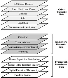
FIGURE 4-1 (Read from the bottom to the top.) A spatial data infrastructure (SDI) typically consists of framework foundation data such as geodetic control, digital elevation and bathymetry, and ortho-imagery. Because of the central nature of people in sustainable development, data on human population distribution are equally important. Where possible, SDIs also contain essential framework thematic data layers, including hydrology, political and other boundaries, transportation resources, and cadastral information. Other thematic information such as socioeconomic data, vegetation, soils, geology, and land cover may be included in the infrastructure (adapted from FGDC, 2002).
Digital Ortho-imagery
An ortho-image is a specially processed image prepared from an aerial photograph or remotely sensed image that has the metric qualities of a traditional line map with the detail of an aerial image.4 Because ortho-images are geographically referenced, they are useful in their own right or as a backdrop upon which other information can be overlaid (e.g., drainage or road networks, utilities, or government boundaries). They also can be used as a reference base map to which other maps or images can be linked to detect changes in the landscape.
Human Population Distribution
Human population distribution refers to the location of people on Earth’s surface. People are both influenced by and have an impact on ecosystems in which they live, and are therefore central to Agenda 21 issues. Information on the geographic distribution of the human population and their attributes are equally as important as other SDI framework foundation data. In the current worldwide development arena, such key issues as good governance, anti-poverty strategies, and the need to promote economic growth with social equity all require population distribution and other demographic data at the local scale. Geographically referenced, standardized census data that can be linked to other layers of geographic data are required to meet national development needs. Progress toward Agenda 21 goals is impeded by the lack of reliable data on human population distribution.
Framework Thematic Data
There is general consensus in the geographic information community that four of the most important framework thematic datasets are Hydrology, Boundaries, Transportation, and Cadastral data (NRC, 1995, 2001; NSDI, 1997).
Hydrology
There are three categories of hydrologic features: (1) surface water features (e.g., oceans, seas, lakes, reservoirs, and ponds), (2) linear features (e.g., shorelines, rivers, canals, and perennial and intermittent streams), and (3) point features (e.g., wells). A complete hydrologic dataset requires information about how the hydrologic network is connected and the direction in which water flows.
Boundaries
Boundaries range from the political borders of countries to administrative units to communal and individual holdings. Without accurate boundary information it is difficult to monitor an activity with a given legal jurisdiction or allocate resources fairly to people within a specific administrative district. Box 4-4 describes the importance of boundary information in Ghana.
Transportation
Transportation networks include roads, railways, waterways, and pipelines. Even in major cities of Africa they are inadequately mapped for such basic functions as delivery and collection services (ECA, 2001).
Cadastral Data
Cadastral data refer to the geographic extent of past, current, and future rights and interests of private and commercial property (FGDC, 2002). A cadastre is a map accompanied by a register showing the ownership or possession of individual units of land. It facilitates efficient land adminis-
|
BOX 4-4 In Ghana, boundary maps (i.e., regional, district, census, electoral, and related maps) contain inaccuracies in the location of boundaries. The problem has confronted researchers, political and security administrators, and development planners for many years. Participants at the National Framework for Geospatial Information Management Steering committee consultations at Dodowa in June 2001 recommended developing a collaborative project to address the problem. The Survey of Ghana recognizes that boundaries are an integral part of the development of a national spatial data framework for the collection, processing, and use of geographic information. Nationally accepted, accurate, and reliable district and sub-district boundary maps are needed as the basis for data collection, processing, and presentation. Presently there are as many versions of the maps as there are producers and users of information, and it is never clear which version is used in national and private documents. |
tration and expedites land-market transactions. The spatial data necessary to describe the geographic extent of property rights and interests includes surveys, legal description reference systems, and parcel-by-parcel surveys and descriptions.
Metadata
Metadata (defined as data about data) describe existing data holdings, making it possible for people outside an agency or organization to access, search, and use geographic data. Metadata help people know that data exist; how, when, or why the data were produced; and where the data reside. For example, when making important land-management decisions, it is helpful to know where to find the needed geographic data (Table 1-1).
A U.S. standardized metadata format, Content Standards for Digital Geospatial Metadata, was approved by the FGDC in 1998. An international metadata standard became available in 2002, and the National Spatial Information Framework of South Africa is compiling a metadata profile based on these standards.
Clearinghouses
Clearinghouses (or catalogs) allow government agencies, non-profit organizations, and commercial participants worldwide to make their geographic data searchable and accessible through the Internet. A clearinghouse carries the potential to reduce duplication of effort in collecting and distributing digital spatial (and non-spatial) data.
Clearinghouses serve three principal functions. First, they provide an Internet-based graphical user interface helping users search for (or “discover”) geographic data with standardized metadata. Second, they allow access to raw digital data and allow standardized access to geographic data through file-transfer-protocol5 directories and online data streaming services. Third, users may access data and process geographic information to make maps over the Internet.
In developed countries national data clearinghouses are now commonplace. For example, a shared data discovery infrastructure was set up across Europe in 1998 (the European Spatial Metadata Infrastructure [ESMI] project). The ESMI project involves mapping organizations of most European countries and provides a common research and development framework to permit discovery of geographic data. Clearinghouse efforts are also underway in the developing world (Box 4-5).
Partnerships
Partnerships bind spatial data infrastructures together at all scales. Groups and government agencies enter into partnerships to freely share geographic data. These partnerships form a basis for many spatial data infrastructures (Table 4-1). The partnership concept is extended worldwide through the GSDI.
Global Spatial Data Infrastructure
The GSDI is an emerging network of public and private national, regional, and international organizations. It involves the development and open sharing of global to local data through a network of clearinghouses. The GSDI advocates the adoption of appropriate standards and practices for sharing data. Currently the secretariat is with the U.S. FGDC (see Appendix C).
The GSDI includes such regional groupings as the European Umbrella Organization for Geographic Information, Permanent Committee on GIS Infrastructure for Asia and the Pacific, Permanent Committee on Spatial Data Infrastructure for the Americas, and the Permanent Committee on GIS Infrastructure for Africa. Such groupings enable participants to benefit from shared experiences and lessons learned in the application of geographic data.
An implementation guide, Developing Spatial Data In-
|
BOX 4-5 Under the auspices of the U.N. Environment Programme (UNEP) in Nairobi, Kenya, a global directory of environmental data is being prepared using UNEP-sponsored metadata and software. Through international collaboration, conversion of the software is underway to make it compatible with FGDC metadata standards. The UNEP metadata holdings will be made available through a search service on the Internet. In South Africa the National Spatial Information Framework project coordinates the development of metadata and an online discovery system. This system uses FGDC metadata standards and related software and supports discovery of geographic data in South Africa and in the greater southern Africa region. The CEOS Information Locator System, built by the International Committee on Earth Observation Satellites, enables users in developing countries to gain access to Earth observation information. Users can also enter, administer, and share their own data and information. Metadata host sites are maintained in China, Norway, Kenya, Japan, Italy, Germany, and Australia, providing regional access to a common and synchronized international collection of metadata. A majority of the sites are using a common method for searching for data. SOURCE: FGDC (2001). |
frastructure: The SDI Cookbook, was released by the GSDI Secretariat during the GSDI-5 conference held in Cartagena, Colombia, in 2001 (GSDI, 2002). The document introduces local, regional, national, and multinational organizations to the common concepts and issues, policies, standards, and recommendations for implementing a globally compatible SDI. The guide provides details on how to establish compatible systems within and between organizations to facilitate information discovery, applications support, and exchange. It also identifies, describes, and references relevant standards and specifications from the ISO, Open GIS Consortium, and the Internet to assemble a coherent vision for their integration (GSDI, 2002).
The GSDI is economical because it enables worldwide cost sharing of data creation and maintenance: Those who produce the data maintain and update it. As a result of the potential benefits of both the GSDI and SDI concepts, developing countries should consider using a standardized SDI that is compatible with the emerging GSDI. Data derived from international development programs (for example, those of USAID) should conform to the standards recommended by the GSDI. In this way data collected by these programs should be rendered more useful.
TELECOMMUNICATIONS INFRASTRUCTURE IN AFRICA
SDIs depend on efficient telecommunications infrastructures (Figure 4-2). In particular the accumulation of data and information without the ability to access, process, and disseminate serves little purpose. In general, telecommunications infrastructures in the developing world are inadequate to support SDIs. Telecommunications technologies that meet the needs for geographic data transfer and information dissemination are vital to close the digital divide between developed and developing countries, between urban and rural areas, and between the rich and the poor (InfoDev, 2001). As a result of this divide the potential impact of geographic information and associated technology on development challenges in Africa are largely unrealized.
Overview
Telecommunications infrastructures in Africa have generally improved during the 1990s (Table 4-2). For example, use of satellite television, the Internet, personal computers, and fixed and cellular telephones is increasing across the continent (Taylor, 1997; ECA, 1999a). Of the roughly 800 million people in Africa (Jensen, 2002)
-
1 person in 13 has a television (62 million),
-
1 in 40 has a fixed telephone line (20 million),
-
1 in 35 has a wireless telephone (24 million),
-
1 in 130 has a personal computer (6 million),
-
1 in 160 uses the Internet (5 million), and
-
1 in 400 has pay television (2 million).
As elsewhere, telecommunications in African countries correlate with the settlement hierarchy. For example, in Tanzania the adoption of telecommunications is greatest in Dar es Salaam, the economic and social nerve center of the country. In such provincial cities as Arusha, Iringa, Tanga, and Mwanza the adoption of these technologies is lower. In rural areas of Africa where 7 out of 10 people live, levels of adoption are lowest (Jensen, 1999) and much of rural Africa has been isolated from international networks. Africa’s diversity is an important characteristic that represents both a strength and a challenge to developing telecommunications infrastructures (Box 4-6). Fortunately adoption of telecommunications technologies will increase in the future because of
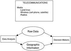
FIGURE 4-2 Ways that geographic data and information may be transferred from NSDI or GSDI clearinghouses to African decision-makers.
TABLE 4-2 Recent Telecommunication Trends in SubSaharan Africa
|
|
1996 |
1999 |
2000 |
|
Fixed line and mobile telephones (per 1,000 people) |
13.4 |
24.3 |
31.6 |
|
Personal computers (per 1,000 people) |
Not available |
8.2 |
9.2 |
|
Internet Users |
648,000 |
2.4 million |
3.7 million |
|
SOURCE: Development Gateway (2002). |
|||
declining unit costs, policy changes and liberalization of markets (ECA, 2001; InfoDev, 2001).
There are growing numbers of kiosks, cyber cafés, and telecenters that offer information and communications technology access and services to the public for a fee. At these venues people can access geographic data and information in villages and participate in technology training to address local development needs. Available technologies include telephones, fax machines, computers, photocopiers, email, and the Internet. In Ghana, for example, wireless pay-phone kiosks provide an inexpensive way to broaden rural access to the networked world (McConnell International, 2000). Regulatory policies that encourage increased telecommunications access and new administrative arrangements allow entrepreneurs to operate profitable enterprises.
Continued improvements in telecommunications infrastructures could enhance the “e-readiness” of African countries to support e-government and e-business. In The Global Information Technology Report 2001-2002: Readiness for the Networked World (World Economic Forum, 2002), Harvard University ranked countries for e-readiness6 based on their capacity to take advantage of information and communication technology networks. Four African countries were among the 75 that were ranked: South Africa, 40th; Egypt, 60th; Zimbabwe, 70th; and Nigeria, 75th. With policy reform and regulatory change African countries could become globally competitive in e-commerce, especially in services (ECA, 2001).
Other organizations are developing and improving telecommunications infrastructure in Africa. These include the African Information Society, African Development Forum, African Telecommunications Union, African Connection, ECA, Economic Commission for West African States, and Common Market for Eastern and Southern African (Box 4-7). International organizations that improve telecommunications infrastructure include the International Telecommunications Union, UNESCO, and the World Bank. In addition, InfoDev funds pilot projects and policy, networking, and human resource development activities that promote the dis-
|
BOX 4-6 Many Africans identify themselves as members of an ethnic group (one or more depending on parentage), name the language they speak as a member of that group, and identify the place (village, camp, town, city) where they live as significant. Commonly the ethnic group name and the language they speak are the same. Importantly, most Africans speak two or more languages—the home language, the lingua franca, and the language of the nation. In addition, many speak English in Anglophone Africa, French in Francophone Africa, or Arabic in North Africa. The number of ethnic groups in Africa is difficult to know precisely because estimates vary. Armstrong (1963) estimated between one thousand and two thousand different languages. For purposes of this report, the estimate of 1,000 ethnic groups is a reasonable minimum. In addition to these groups, such European settlers as the English in east and South Africa, the Boers in South Africa, and the Asians in eastern and South Africa are significant in their national populations and influence on linguistic diversity. |
|
6 |
E-readiness describes the extent to which a country’s business environment is conducive to Internet-based commercial opportunities. It is a concept that spans a wide range of factors, from the sophistication of the telecommunications infrastructure to the security of credit-card transactions and the literacy of the population (<http://www.ebusinessforum.com>). |
|
BOX 4-7 U.N. Economic Commission for Africa (ECA) In 1996 the ECA adopted an initiative to create an information infrastructure for Africa through access to a global infrastructure. The goal is to provide information for development and to build national communications capacity in member states. The ECA emphasizes the importance of the involvement of government, non-government, and private-sector institutions as well as the science and technology communities. The plan also stresses the need for policy and legislative reform at the national level to promote effective decision-making (ECA, 1999b). Economic Commission for West African States (ECOWAS) The Economic Commission for West African States spearheaded the INTELCOM I programme to connect the capital cities of West Africa by microwave links. Subsequently, ECOWAS recommended that priority be given to completing the INTELCOM II programme to facilitate telecommunications development through improved satellite or fiber-optics links. The goal of this program is to provide regional infrastructures to stimulate trade and investments, in part through involvement of the private sector. The program strives to connect existing networks in the areas of transportation, communications, and energy (ECOWAS, 2002). Common Market for Eastern and Southern Africa (COMESA) The Common Market for Eastern and Southern Africa is promoting the establishment of a regional telecommunications network to increase trade among the member states. The network includes a mixture of fiber-optic, microwave, and satellite connectivity that will facilitate the transfer of data and television programming. Where possible, the network follows the layout of existing infrastructure. The network is administered by COMTEL Communications, Ltd. and private-sector investors will have the majority equity shareholding (COMESA, 2002). |
semination of information and communication technologies. Finally, Volunteers in Technical Assistance (VITA)7 and Wavix, Inc.,8 are launching the VITA Connect Network to provide information and low-cost, remote-area connectivity for development and humanitarian organizations. The activity will rely on its Low Earth Orbiting Satellite—the first satellite operated by a non-governmental organization focusing on development (VITA, 2002).
The U.S. government also is enhancing African telecommunications infrastructure. For example, the Leland Initiative, a five-year, $15 million activity, promotes Internet connectivity and its sustainability in 21 African countries. Currently, regulatory reform is the focus of the initiative (USAID, 2002). In another example, the Radio and Internet for the Communication of Hydro-meteorological and Climate Related Information Project (RANET) provides information access and support to rural communities on topics such as weather, agriculture, education, and health (RANET, 2002). NOAA, the University of Oklahoma, and USAID provide technical and financial support to RANET.
The U.S. government (e.g., USAID and NOAA) should continue to assist African countries in improving telecommunications infrastructure so that large computer files containing geographic data can be readily distributed within national and global spatial data infrastructures.
Fixed-line and Wireless Telephone Service
In 2001 total telephone use (fixed-line plus wireless telephones) per 100 people was 121.1 in developed countries and 19.8 in developing countries (ITU, 2002b). In Africa the countries of the Sahel and central Africa, such as Niger and Democratic Republic of Congo, have less than two telephone lines for every 1,000 people. Northern Africa and South Africa have a teledensity9 around 35 per 1,000 people, and West and East African coastal countries have teledensities between 2.5 and 10 per 1,000 people (ECA, 1999a). When the Commission for Worldwide Telecommunications Development published the Missing Link Report in 1984, there were more telephones in Tokyo than in all of Africa. Today there are twice as many telephones in Africa than in Tokyo (ITU, 2002a).
Although charges for local and international phone calls are declining, they remain high in comparison with rates in Europe and North America (ITU, 2001). For most Africans, making a telephone call is an unaffordable luxury. Telephone subscription costs range from one-sixth to nearly one-half of per capita gross domestic product (ITU, 2001). Moreover, the quality of telephone service is variable (ITU, 2001), and the average waiting time for the installation of a telephone is 3.5 years in sub-Saharan Africa (ITU, 2001).
Fortunately, wireless technology is expanding telephone networks in Africa. In 2001 most countries in sub-Saharan
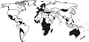
FIGURE 4-3 Countries with more wireless (mobile) than fixed telephone lines in 2001. SOURCE: ITU (2002a).
Africa had more wireless (mobile) than fixed-wire subscribers (Figure 4-3). The success of this technology relates to the lower costs of providing wireless coverage rather than installing fixed copper lines, and to liberalization of telecommunications regulations and the resulting competition in wireless services.
Computer Infrastructure
Worldwide the cost of computers is decreasing and the number of computers is increasing (Taylor, 1997). In northern Africa and South Africa there are more computers per capita than in the rest of Africa (Table 4-3). For example, South Africa has roughly 6 computers per 1,000 people, whereas other sub-Saharan countries combined have less than 1 computer per 1,000 people. By comparison, the United States had 459 computers per 1,000 people in 1998 (World Bank, 2001, Table 19).
Typically, computers are imported into African countries. Consequently, prices are high when compared to per capita gross domestic product. The high cost of computers limits the rate of Internet diffusion and access to geographic data clearinghouses. Most personal and mainframe computers are in South Africa, and most of them are confined to ministries
TABLE 4-3 Personal Computers in Africa
|
|
Personal Computers (1000s) |
Personal Computers per 100 people |
|
Northern Africa |
2,169 |
1.64 |
|
South Africa |
2,700 |
6.18 |
|
Other Sub-Saharan |
2,455 |
0.47 |
|
All Africa |
7,324 |
1.05 |
|
SOURCE: ITU (2001). |
||
of finance (for government payroll), large parastatals, telecommunications operators, banks, and insurance companies (Jensen, 1999).
The high cost of new computers is offset to some extent by organizations that transfer refurbished computers to Africa without charge or for a nominal fee. For example, Computer Aid International has distributed a total of 1,800 used computers to Ghana, Mozambique, South Africa, and Zimbabwe. Additionally, open-source software10 has become increasingly important because development and maintenance costs are incurred by communities of volunteers rather than by users, and the software is available either without charge or for the cost of disks, manuals, and technical support. Additionally, by using the Internet Africans can use computers in Europe and North America.
A range of challenges face computer users in Africa. Poor computer maintenance, insufficient skills to diagnose system problems, and underuse of existing computers are commonplace (ECA, 1999a). These problems are the result of insufficient financial resources, limited training in computer maintenance and software trouble-shooting, and lack of technical support by computer manufacturers. In sub-Saharan Africa environmental conditions (such as dust, heat, and heavy rains) and irregular or nonexistent electricity supplies also hamper computer use and disrupt Internet connections. Power outages that last many hours are a regular occurrence, even in capital cities (ECA, 1999a), and poor transportation networks hinder distribution of physical goods.
Internet Infrastructure
In November 1991 South Africa established the first Internet connection in Africa and continues to lead in
TABLE 4-4 Internet in Africa in 2001
|
Region |
Dial-Up Internet Subscribers |
International Outgoing Bandwidth Kbps |
Number of Internet Service Providers |
Population millions |
Cities with Points of Penetration |
Dial-Up Subscribers per Million People |
|
Central |
10,100 |
3,072 |
17 |
71.48 |
12 |
141 |
|
East |
120,600 |
24,894 |
80 |
216.42 |
28 |
557 |
|
North |
279,000 |
294,096 |
360 |
139.25 |
36 |
2,004 |
|
Southa |
80,350 |
33,044 |
35 |
69.42 |
38 |
1,157 |
|
South Africa |
750,000 |
350,000 |
80 |
44.31 |
100 |
16,926 |
|
West |
122,725 |
68,072 |
77 |
228.78 |
34 |
536 |
|
Africa |
1,362,775 |
773,178 |
649 |
769.66 |
248 |
1,771 |
|
aExclusive of South Africa. SOURCE :National Intelligence Council (2001). |
||||||
Internet-related developments (Table 4-4). Eritrea, the last country to be connected, linked up in November 2000 (ITU, 2001). Currently there are about 649 Internet service providers in Africa and the number will continue to increase as Internet markets open.
The number of Internet users in Africa is difficult to estimate because there may be several users per subscription and because of the popularity of public facilities (e.g., kiosks, cyber cafés, and telecenters). In 2001 Africa had an estimated 4.4 million Internet users. More than half of these users lived in South Africa, and one-sixth of them lived in the Maghreb countries. An estimated 1.3 million users were in sub-Saharan countries (excluding South Africa) (ITU, 2001). Combined, these numbers account for 0.15 percent of total global Internet connectivity (ITU, 2001).
International bandwidth11 for African countries is low (Figure 4-4). For example, the 400,000 people living in Luxembourg share more international Internet bandwidth than Africa’s 760 million people (ITU, 2001). Until recently few countries outside South Africa had international Internet links larger than 64 kilobytes per second (equal to a common capacity of telephone modems in North America), but in 2002 nearly half the countries have links of 2 megabytes per second or more, and 20 percent have outgoing links of 5 megabytes per second or more (Jensen, 2002). Because it can be measured reliably, bandwidth can be used to indicate a country’s progress toward increased access to information.
In Africa satellite-based Internet access is increasing. For example, satellite dishes provide incoming bandwidth of 64 kilobytes per second for about U.S.$30-$1,000 per month, which is cheaper than services available from local operators (Jensen, 2002). Two-way satellite-based Internet services use very small aperture terminals (VSAT)12 to connect directly to the United States or Europe when regulations permit. The adoption of VSATs is greatest in the Democratic Republic of the Congo, Ghana, Mozambique, Nigeria, Tanzania, Uganda, and Zambia. A number of consumer-oriented VSAT services are scheduled. The target price is currently between U.S.$700-$900 for VSAT equipment providing 56 kilobytes per second outgoing capacity and 200-400 kilobytes per second incoming capacity (Jensen, 2002).
Despite increasing capacity, bandwidth continues to limit data transfer of large geographic data files across the Internet. For example, a single Landsat 7 Enhanced Thematic Mapper Plus (ETM+) satellite image contains 390 megabytes of data. Similarly, a single Space Imaging IKONOS-2 (11 × 11 km area, 1 × 1m resolution) panchromatic satellite image is 121 megabytes.13 Using file-compression technologies and targeting data that are most relevant to the application are two approaches that ameliorate this problem.
Cost is another factor that limits transfer of data across the Internet. In Africa the average cost for a local dial-up Internet account is about $68 a month for 20 hours (usage fees and local-call telephone time are included but not telephone line rental) (Jensen, 2002). Internet service provider subscription charges vary from $10 to $100 a month. These variations reflect different levels of market maturity, variations in tariff policies among telecommunications operators, and different regulations on private wireless data services and on access to international telecommunications bandwidth (Jensen, 2002). According to the International Telecommunications Union (2001):
Internet access prices are generally exorbitant on the continent especially relative to the prevailing low per capita incomes.… There is a double whammy because, in addition to Internet access, dial-up users must also pay the cost of a telephone connection and telephone usage charges.
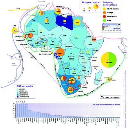
FIGURE 4-4 Internet bandwidth in African countries in March 2002. The colored circle in each country shows the international bandwidth in bits per capita (8 bits = 1 byte). SOURCE: <http://www.idrc.ca/acacia/divide/>.
Internet prices are high for three reasons. First, African countries must pay the cost of international Internet bandwidth. Second, countries do not benefit from economies of scale and do not have bargaining power to leverage cheaper prices because demand for the Internet is low. Third, land-locked countries are unconnected to the marine cables that ring the continent; therefore, Internet connectivity is limited to more expensive satellite connections.
Internet growth will continue in Africa and will be driven by technological innovations, the growth of the global Internet, and an increasingly favorable policy environment. Nonetheless, for now at least the preferred method of geographic data transfer is the compact disk.
Media
Media such as radio, television, and print are important for mass dissemination of geographic information (derived from analyses of raw data) on such topics as food security, human and livestock health, weather, environmental quality, and potential or evolving natural disasters. The audience for this information includes farmers, natural resource manag-
TABLE 4-5 WorldSpace Satellite Radio Partnership Activities
|
Partnering Organization |
Activities |
Goals |
|
African Center for Meteorological Forecasting (<http://www.acmad.ne/>) |
Provides local communities with wind-up radios and small transmitters to transmit weather data. |
Provide local populations with field weather stations to collect climate information and food security data from their villages and transmit this by laptop computers to a satellite for re-transmission to a ground station. |
|
Arid Lands Information Network (<http://www.alin.or.ke/>) |
Helps local communities transmit and receive information on disease, rainfall, crops and livestock, and other data. |
Improve the local economy. |
|
SATELLIFE (<http://www.healthnet.org/>) |
Provides a public health channel in four countries (Ethiopia, Kenya, Uganda, and, Zimbabwe). |
Connect health practitioners to information about the treatment and prevention of such diseases as HIV/AIDS, malaria, and tuberculosis. |
ers, and the general public. Radio, with the largest audience, is the primary source of information.
Media statistics should be interpreted with care because people commonly share information sources. For example, there are radio-listening clubs (Communication Initiative, 2002a), and newspaper readership is more than 10 people per paper (ECA, 1999a).
Radio
Radio is the most accessible and cost-effective means of mass communication. It overcomes barriers of distance and isolation, illiteracy, and language diversity, and is a source of information on such topics as weather, agriculture, health, local development, and education. The number of radios increased from 33 million in 1970 (93 per 1,000 people) to 158 million in 1997 (216 per 1,000 people) (UNESCO, 1999). By 1999 radio transmitter networks reached over 60 percent of sub-Saharan Africa’s population (Jensen, 1999).
Radio stations fill an important role in broadcasting to rural populations. For example, Radio Douentza in lightly settled northern Mali serves an area of 15,000 square kilometers using one 250-watt transmitter (Communication Initiative, 2002b). In addition, satellite-based broadcasting is available, though expensive. With a receiver costing U.S.$225-$375, over 100 audio and visual digital channels are accessible from WorldSpace Corporation’s AfriStar satellite. WorldSpace receivers provide digital audio channels and can serve as a modem for the Internet (Slifer-Mbacke et al., 2000). WorldSpace Foundation is partnering with several organizations, such as the African Center for Meteorological Forecasting, Arid Lands Information Network, and SATELLIFE to increase information dissemination in Africa (Table 4-5).
Television
Television provides a convenient and effective means of conveying geographic information. The coverage of television in Africa is similar to radio but more restricted to major urban centers. The number of television sets in Africa increased from 4.5 per 1,000 people in 1970 to 60 per 1,000 people in 1997 (UNESCO, 1999). By comparison, in1997, developed countries had 548 sets per 1,000 people.
New technologies such as digital television broadcasting systems offer a range of services, including transmission of Web pages, e-mail, and graphics. News and information can be obtained from WorldSpace’s Channel Africa, a satellite-based channel that was launched last year. African Journal, a weekly one-hour call-in television program broadcast live by stations in 27 sub-Saharan African countries, focuses on Agenda 21 issues.
Print Media
Although less widespread than radio and television, print also is a valuable medium for information dissemination. Print is especially useful for distributing maps, tables, and figures. Because rural populations have limited access to this medium, most readers are from urban areas. It is estimated that newspapers have a circulation of 12 million (16 papers per 1,000 people) (UNESCO, 1999).
Convergence of Telecommunications Technologies
The convergence of telecommunications technologies is important because it increases the options for transferring and disseminating geographic data and information. For example, e-mail can be delivered by wireless phone, and voice mail can be combined with public-access telephones to disseminate information to rural areas.14 These technologies play a similar role to radio wherein information generated from data analysis is communicated in a non-spatial format.
The Internet and other media also are linked. Radio stations, newspapers, and journals have Web sites and obtain information from the Internet. Radio stations also download audio and broadcast over the Internet. In Mozambique, the Internet is accessible over cable. In other words, there are
|
14 |
For example, see Voxiva’s pilot project in Latin America (<http://www.voxiva.net/>). |
multiple ways of conveying geographic information to the public, and their reach is expanding.
SUMMARY
Spatial data infrastructures (SDIs) are a popular framework for managing geographic data and information. They exist on the national and global levels (NSDI and GSDI, respectively). African countries are at various points in development of their SDIs. SDIs and telecommunications infrastructures are intimately linked. To realize the full potential of an SDI requires a telecommunications infrastructure that facilitates access, use, and sharing of geographic data and information. Although telecommunications infrastructures are improving in Africa, they currently limit transmission of vital data and information for Agenda 21 issues. However, Africa’s telecommunication links to the rest of the world likely will improve with a large number of international telecommunication infrastructure building initiatives that have been announced in the last few years (Jensen, 2002).
The next two chapters examine the rich array of geographic data sources that could be incorporated into African SDIs for effective application to environmental and developmental challenges as long as the necessary infrastructure is in place.
REFERENCES
Armstrong, R .G. 1963. Vernacular Languages and Cultures in Modern Africa. In Language in Africa, J. Spencer, ed. Cambridge, England: Cambridge University Press
Bassolé, A., J. Brunner, and D. B. Tunstall. 2001. GIS: Supporting Environmental Planning and Management in West Africa. Washington, DC: World Resources Institute.
COMESA (Common Market for Eastern and Southern Africa). 2002. COMESA Transport and Communications. COMTEL Project Brief. Available at <http://www.comesa.int/comms/comtelb.htm>. Accessed July 9, 2002.
Communication Initiative, The. 2002a. DTR Radio Listening Clubs in Zambia. Available at <http://www.comminit.com/drum_beat_141.html >. Accessed June 27, 2002.
Communication Initiative, The. 2002b. Radio Douentza: Mali. Available at <http://www.cominit.com/pdsmay15/sld-1210.html>. Accessed July 2, 2002.
Development Gateway. 2002. Available at <http://www.developmentgateway.org/>. Accessed May 1, 2002.
ECA (Economic Commission for Africa). 1999a. Strengthening Africa’s Information Infrastructure. Report from African Development Forum. Available at <http://www.uneca.org/adf99/infrastructure.htm>. Accessed January 28, 2002.
ECA. 1999b. National Information and Communications Infrastructure in Africa. Developing National Information and Communications Infrastructure (NICI) Policies, Plans and Strategies: the “why” and “how”. Available at <http://www.uneca.org/aisi/nici> Accessed July 9, 2002.
ECA. 2001. The Future Orientation of Geoinformation Activities in Africa: Synthesis. Available at <http://www.uneca.org/eca_resources/Conference_Reports_and_Other_Documents/disd/codi/docs/doc3EN.pdf>. Accessed May 15, 2002.
ECOWAS (Economic Commission for West African States). 2002. Achievements of ECOWAS: Development of Physical Infrastructure for Roads, Telecommunications, and Energy. Available at <http://www.ecowas.int/sitecedeao/english/achievements-2.htm>. Accessed July 9, 2002.
EIS-Africa. (Environmental Information System-Africa). 2001. Environmental Information Systems Development in Sub-Saharan Africa: Approaches, Lessons, and Challenges. E. Gavin and J. Gyamfi-Aidoo, eds. EIS-Africa.
EIS-Africa. 2002. Geo-information Supports Decision-making in Africa: An EIS-Africa Position Paper (draft). Available at <http://www.eisafrica.org/DOCS/EIS-AFRICAwssd_statement-draft8.doc>. Accessed June 27, 2002.
FDGC (Federal Geographic Data Committee). 1996. The National Spatial Data Infrastructure. Available at <http://www.fgdc.gov/nsdi/nsdi.html>. Accessed May 31, 2002.
FGDC. 2001. Clearinghouses in Europe and Africa. Available at <http://www.fgdc.gov/clearinghouse/participation/eurafrica.html>. Accessed April 10, 2001.
FGDC. 2002. Overview: What the Framework Approach Involves. Available at <http://www.fgdc.gov/framework/overview.html>. Accessed April 24, 2002.
Groot, R. 2001. Reform of Government and the Future Performance of National Surveys. Computers, Environment and Urban Systems 25(4-5):367-387.
GSDI (Global Spatial Data Infrastructure). 2002. Developing Spatial Data Infrastructure: The SDI Cookbook, D. Nebert, ed. Available at <http://www.gsdi.org/pubs/cookbook/cookbook0515.pdf >. Accessed June 28, 2002.
InfoDev (Information for Development Program). 2001. Annual Report 2001. Washington, DC: World Bank.
ITU (International Telecommunication Union). 2001. African Telecommunication Indicators 2001. Geneva: ITU.
ITU. 2002a. The New Missing Link: The Digital Divide. Conference proceedings: World Telecommunication Development Conference, March 18-27. Available at: <http://www.itu.int/ITU-D/conferences/wtdc/2002/brochure/missing_link.html>. Accessed May 18, 2002.
ITU. 2002b. World Telecommunication Development Report: Reinventing Telecoms . 6th Edition. Geneva: ITU.
Jensen, M. 1999. ICT Infrastructure in Africa. Available at <http://www3.sn.apc.org/africa/intra.htm>. Accessed May 3, 2002.
Jensen, M. February 2002. The African Internet: A Status Report. Updated version. Available at <http://www3.wn.apc.org/africa/>. Accessed May 3, 2002
Lachman, B. E., A. Wong, D. Knopman, and K. Gavin. 2001. Lessons for the Global Spatial Data Infrastructure: International Case Study Analysis. Washington, DC: RAND Science and Technology Policy Institute.
Longley, P.A., M.F. Goodchild, D.J. Maguier, and D.W. Rhind. 2001. Geographic Information Systems and Science. New York: John Wiley and Sons.
McConnell International. 2000. Risk E-Business: Seizing the Opportunity of Global E-Readiness. Available at <http://www.mcconnellinternational.com/ereadiness/EReadinessReport.htm>. Accessed May 13, 2002.
Moeller, J. 2001. Spatial Data Infrastructures: A Local to Global View. Available at <http://gsdi.org/PPT/unrcc01.ppt>. Accessed May 31, 2002
Nairn, A. 1999. Commonwealth Government Initiatives to Support the Development of the Australian Spatial Data Infrastructure. Commonwealth of Australia. Available at <http://www.auslig.gov.au/corpinfo/publications/technical/docs/msasdi.pdf>. Accessed July 1, 2002.
National Intelligence Council. 2001.Workshop on Information Technology in Africa: Conference Report (unpublished).
NRC (National Research Council). 1993. Toward a Coordinated Spatial Data Infrastructure for the Nation. Washington, DC: National Academy Press.
NRC. 1995. A Data Foundation for the National Spatial Data Infrastructure. Washington, DC: National Academy Press.
NRC. 2001. National Spatial Data Infrastructure Partnership Programs: Rethinking the Focus. Washington, DC: National Academy Press.
NSDI (National Spatial Data Infrastructure). 1997. Framework: Introduction and Guide. Washington, DC: Federal Geographic Data Committee.
OGC (Open GIS Consortium). 2002. Available at <http://www.opengis.org/index.htm>. Accessed June 25, 2002.
RANET (Radio and Internet for the Communication of Hydro-meteorological and Climate Related Information Project). 2002. Via satellite:
RANET Climate Information Pages. Available at <http://www.oar.noaa.gov/spotlite/archive/spot_ranet.html>. Accessed May 2, 2002.
Slifer-Mbacke, L., H. Ladd, and R. Bourke. 2000. Worldspace Foundation, SATELLIFE Create First Public Health Channel for Entire African Continent. Available at <http://www.procaare.org/newsview.php/32/>. Accessed July 11, 2002.
Taylor, D. R. F. 1997. Modern Cartography, Policy Issues and the Developing Nations. Pp 185-213 in Policy Issues in Modern Cartography, D. R. F. Taylor, ed. Oxford: Pergamon.
Thrower, N. J. and J. R. Jensen. 1976. The Orthophoto and Orthophotomap: Characteristics, Development, and Aspects of Cartographic Communication. American Cartographer 3(1):39-56.
UNESCO (U.N. Educational, Scientific, and Cultural Organization). 1999. UNESCO Statistical Yearbook, 1999. Available at <http://www.uis.unesco.org/en/stats/stats0.htm>. Accessed May 31, 2002.
USAID (U.S. Agency for International Development). 2002. Leland Initiative Website. Available at <http://www.usaid.gov/leland/>. Accessed May 2, 2002.
VITA (Volunteers in Technical Assistance). 2002. Available at <http://www.vita-connect.org>. Accessed July 11, 2002.
World Bank, 2001. World Development Report 2000/2001: Attacking poverty. Available at <http://www.worldbank.org/poverty/wdrpoverty/report/index.htm>. Accessed June 5, 2002.
World Economic Forum. 2002. The Global Information Technology Report 2001-2002: Readiness for the Networked World. G. Kirkman, P. Cornelius, J. Sachs, and K. Schwab, eds. Available at <http://www.cid.harvard.edu/cr/gitrr_030202.html>. Accessed July 1, 2002.


