
6
Geographic Data for Sustainable Development II: Other Thematic Data
INTRODUCTION
Drawing on examples of remotely sensed satellite data that are mostly low in cost, this chapter describes the sources, adequacy, and current applications of important thematic data types for monitoring and managing natural and human-made resources in Africa. These data types form the organizational framework for the chapter. First, the chapter addresses land-cover and land-use data (e.g., depicting agriculture, savannah, forest, settlements). Second, it examines biophysical data (e.g., rainfall, and data relating to the physical condition of vegetation). Finally, it describes data for managing human health (e.g., environmental data pertaining to vector habitats). These thematic data types supplement the framework foundation data (Chapter 5) that form the core of a country’s geographic data needs for addressing Agenda 21 issues. Much of the technical information on data sources in Chapter 6 is found in Annex 6.
LAND COVER AND LAND USE
The pace, magnitude, and scale of human alterations of Earth’s land surface are unprecedented in human history. Consequently, land-cover and land-use data are central to such Agenda 21 issues as combating deforestation, managing sustainable settlement growth, and protecting the quality and supply of water resources (Table 2-5). In light of the human impacts on the landscape, there is a need to establish baseline datasets against which changes in land cover and land use can be assessed. “Land cover” refers to the type of material present on the landscape (e.g., water, sand, crops, forest, wetland, human structures). “Land use” refers to what people do on the land surface (e.g., agriculture, commerce, settlement).
The International Geosphere-Biosphere Programme (IGBP) and the International Human Dimensions of Global Environmental Change Programme (IHDP) suggest that
[o]ver the coming decades, the global effects of land use and cover change may be as significant, or more so, than those associated with potential climate change. Unlike climate change per se, land use and cover change are known and undisputed aspects of global environmental change. These changes and their impacts are with us now, ranging from potential climate warming to land degradation and biodiversity loss and from food production to spread of infectious diseases (IGBP-IHDP, 2002).
In addition to understanding changes that have already occurred, land-cover data are needed to generate scenarios of future modification of the Earth system (Lambin and Geist, 2001; Geist and Lambin, 2002).
Land-use and land-cover data can be obtained using in situ field measurements or remote-sensing technology. However, access to raw remotely sensed data alone is insufficient to feed decision-support systems. To extract useful thematic information such as land-cover maps from the raw imagery decision-makers must rely on intermediate steps involving scientific expertise, use of calibration data, and image-processing resources.
Different applications of land-use and land-cover information normally require that remotely sensed data be obtained at different spatial resolutions. For convenience the land-cover information is often grouped into four levels that can be associated with remotely sensed data acquired at different spatial resolutions (Anderson et al., 1976) (Figure 6-1). Level I nominal-scale land-cover information might identify an area as forested. Level II might make a further distinction between deciduous and coniferous forest. Level III might include information on particular species (e.g., acacia). Level IV might include sub-species information. The extremely high level of detail needed for land cover Levels III and IV is usually derived from high spatial resolution remote-sensor data such as that provided by large-scale aerial photography or certain commercial satellite remote-sensing systems. Information may be extracted using classical photo-
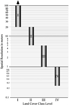
FIGURE 6-1 The relationship between U.S. Geological Survey land-cover and land-use classes and the required spatial resolution of the imagery. SOURCE: Pearson Education, Inc., adapted from Jensen (2000).
interpretation techniques applied to analog (hard-copy) imagery or digital image processing techniques applied to digital remote-sensor data (including digitized aerial photography) (Jensen, 1996).
The following discussion begins with a brief overview of the importance of high spatial resolution aerial photography and satellite imagery to obtain detailed Level III and IV land-cover and land-use information for urban applications and progresses to lower spatial resolution imagery for regional and global applications (mainly associated with Levels I and II). Several sources of remotely sensed data may be available for a given spatial resolution. This discussion deals primarily with publicly available and commercial sources from the United States.
Urban and Suburban Land Cover and Land Use
Many Agenda 21 issues concentrate on urban and suburban areas (Table 2-5). The detailed land-use and land-cover information needed in these settings is derived from high spatial resolution aerial photography or satellite imagery (Table 6-1, Figure 6-2). Since 1994, such companies as Space Imaging and DigitalGlobe have marketed high spatial resolution satellite data (approximately 1 × 1 m to 4 × 4 m) (Annex Box 6-1). Examples of Space Imaging’s IKONOS imagery are shown in Figure 6-3.
Ways need to be found to make high spatial resolution imagery accessible to users in Africa. Currently, these data are expensive (Table 6-2), and more affordable, lower spatial resolution imagery is an inadequate substitute in urban environments.
Regional and Global Land Cover
The land cover of much of Africa can be inventoried using medium to coarse spatial resolution satellite imagery (e.g., 20 to 1000 m). Normally this imagery must be multispectral. This section discusses five sources of these data, all of which can be obtained inexpensively. Additional resources can be found at the World Data Center for Remotely Sensed Land Data.1
Land-Cover Data Source A: Advanced Very High Resolution Radiometer (AVHRR) Imagery
NOAA’s AVHRR is a widely used source of satellite data for natural resource management and early warning systems in Africa. This class of sensor flies onboard NOAA’s operational satellites (Annex Box 6-2), and will likely continue operating until 2018 (Annex Box 6-3). AVHRR is a sustained source of low-cost data with a spatial resolution of ~1 × 1 km.
The Global Land Cover Dataset
AVHRR images from 1992 and 1993 are the source for the Global Land Cover dataset. The dataset was compiled for broad use in environmental research and modeling (Loveland et al., 2000). It was developed by IGBP Data and Information Systems Focus 1 activity (Townshend and Skole, 1995)2 and implemented by the USGS EROS Data Center, the European Commission’s Joint Research Centre,
TABLE 6-1 Urban and Suburban Applications and the Minimum Remote-Sensing Resolutions Required to Obtain Such Information
|
|
Minimum Resolution Requirements |
||
|
Attributes |
Temporal |
Spatial |
Spectrala |
|
Land Use/Land Cover |
|||
|
L1—USGS Level I |
5-10 years |
20-100 m |
V-NIR-MIR-Radar |
|
L2—USGS Level II |
5-10 years |
5-20 m |
V-NIR-MIR-Radar |
|
L3—USGS Level III |
3-5 years |
1-5 m |
Pan-V-NIR-MIR |
|
L4—USGS Level IV |
1-3 years |
0.25-1 m |
Panchromatic |
|
Building and Property Infrastructure |
|||
|
B1—Building perimeter, area, height, and cadastral information (property lines) |
1-5 years |
0.25-0.5 m |
Pan-Visible |
|
Transportation Infrastructure |
|||
|
T1—General road centerline |
1-5 years |
1-30 m |
Pan-V-NIR |
|
T2—Precise road width |
1-2 years |
0.25-0.5 m |
Pan-Visible |
|
T3—Traffic count studies (e.g., cars, airplanes) |
5-10 min |
0.25-0.5 m |
Pan-Visible |
|
T4—Parking studies |
10-60 min |
0.25-0.5 m |
Pan-Visible |
|
Utility Infrastructure |
|||
|
U1—General utility line mapping and routing |
1-5 years |
1-30 m |
Pan-V-NIR |
|
U2—Precise utility line width, right-of-way |
1-2 years |
0.25-0.6 m |
Pan-Visible |
|
U3—Location of poles, manholes, substations |
1-2 years |
0.25-0.6 m |
Panchromatic |
|
Digital Elevation Model (DEM) Creation |
|||
|
D1—Large scale DEM |
5-10 years |
0.25-0.5 m |
Pan-Visible |
|
D2—Large scale slope map |
5-10 years |
0.25-0.5 m |
Pan-Visible |
|
Socioeconomic Characteristics |
|||
|
S1—Local population estimation |
5-7 years |
0.25-5 m |
Pan-V-NIR |
|
S2—Regional and national population estimation |
5-15 years |
5-20 m |
Pan-V-NIR |
|
S3—Quality of life indicators |
5-10 years |
0.25-30 m |
Pan-V-NIR |
|
Energy Demand and Conservation |
|||
|
E1—Energy demand and production potential |
1-5 years |
0.25-1 m |
Pan-V-NIR |
|
E2—Building insulation surveys |
1-5 years |
1-5 m |
TIR |
|
Critical Environmental Area Assessment |
|||
|
C1—Stable sensitive environments |
1-2 years |
1-10 m |
V-NIR-MIR |
|
C2—Dynamic sensitive environments |
1-6 months |
0.25-2 m |
V-NIR-MIR-TIR |
|
Disaster Emergency Response |
|||
|
DE1—Pre-emergency imagery |
1-5 years |
1-5 m |
Pan-V-NIR |
|
DE2—Post-emergency imagery |
12 hr-2 days |
0.25-2 m |
Pan-V-NIR-Radar |
|
DE3—Damaged housing stock |
1-2 days |
0.25-1 m |
Pan-V-NIR |
|
DE4—Damaged transportation |
1-2 days |
0.25-1 m |
Pan-V-NIR |
|
DE5—Damaged utilities, services |
1-2 days |
0.25-1 m |
Pan-V-NIR |
|
Meteorological Data |
|||
|
M1—Weather prediction |
3-25 min |
1-8 km |
V-NIR-TIR |
|
M2—Current temperature |
3-25 min |
1-8 km |
TIR |
|
M3—Clear air and precipitation mode |
6-10 min |
1 km |
WSR-88D Radar |
|
M4—Severe weather mode |
5 min |
1 km |
WSR-88D Radar |
|
M5—Monitoring urban heat island effect |
12-24 hr |
5-30 m |
TIR |
|
aSpectral resolution is the extent to which an application requires detection of light within narrow bands of the electromagnetic spectrum such as visible blue, green, and red light (V), a single broad band of visible light (e.g., encompassing both green and red light; Pan), near-infrared (NIR) energy, middle-infrared (MIR), and thermal-infrared (TIR). SOURCE: Jensen and Cowen, 1999. |
|||
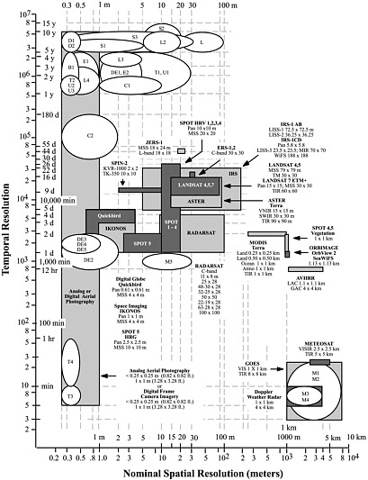
FIGURE 6-2 The relationship between the spatial and temporal resolution of urban and suburban attributes and the spatial and temporal resolution of various aerial and sub-orbital remote-sensing systems. The clear polygons represent the spatial and temporal requirements for selected urban attributes listed in Table 6-1. Gray boxes depict the spatial and temporal characteristics of selected major remote-sensing systems that may be used to extract the required urban information (updated from Jensen and Cowen, 1999).
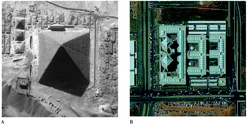
FIGURE 6-3 IKONOS 1 × 1 m panchromatic imagery of (a) the Grand Pyramid in Giza obtained on November 17, 1999, and (b) 1 × 1 m pan-sharpened image of a mosque in Abuja, Nigeria, obtained on November 7, 2001 (courtesy of Space Imaging, Inc.).
and the NASA Earth Observing System (EOS) Pathfinder program.
The Global Land Cover dataset is available by continent, including Africa (Figures 6-4 and 6-5). Additionally, there are seven global datasets, each using a different landscape classification:
-
Global Ecosystems (Olson, 1994a,b);
-
IGBP Land Cover Classification (Belward, 1996);
-
U.S. Geological Survey Land Use/Land Cover System (Anderson et al., 1976);
-
Simple Biosphere Model (Sellers et al., 1996);
-
Simple Biosphere 2 Model (Sellers et al., 1996);
-
Biosphere Atmosphere Transfer Scheme (Dickinson et al., 1986); and
-
Vegetation Lifeform (Running et al., 1995).
The first version of the dataset was released in 19973 and was subjected to a formal accuracy assessment.4 A revised version is now available, although the accuracy of this version has yet to be formally assessed. Unless protected by copyrights or trade secret agreements, all data generated for the Global Land Cover dataset (source, interpretations, attributes, and derived data) are distributed at cost of filing a user request through the USGS EROS Data Center Distributed Active Archive Center for land processes data (USGS, 2002a).
Tropical Forest Extent
AVHRR data were used by the Tropical Ecosystem Environment Observations by Satellite (TREES) project, a European Commission initiative, to map tropical forest extent.5 TREES activities were coordinated with those of the Global Land Cover project through the IGBP Data and Information Systems program.
The first phase of TREES produced a baseline assessment of humid tropical forest cover for 1992. Three regional vegetation maps (each at a scale of 1:5,000,000) have been published or are under development: (1) Central Africa (Mayaux et al., 1997), (2) South America (Eva et al., 1998), and (3) continental Southeast Asia (in preparation) (TREES, 2002). The second phase of the project assessed forested area change in the humid tropics. The resulting “Hot Spot Report” (Achard et al., 1998) highlights areas with rapid forest-cover changes. Hot spot maps are available for central Africa (Figure 6-6), West Africa, and Madagascar (TREES, 2002).
|
3 |
As an International Geosphere Biosphere Program, Data and Information System, initiative led by the Land Cover Working Group. |
|
4 |
This included validation of the land-cover maps by organizations including the Miombo Network (Chapter 7). The product is known to contain some inaccuracies, particularly for cropland which is difficult to map in Africa. Loveland et al. (2000) discuss the accuracy of the dataset. |
|
5 |
TREES, part of a project called World Forest Watch involving space agencies worldwide, was initiated during the International Space Year in 1992. |
TABLE 6-2 Costs of Remotely Sensed Satellite Imagery
|
Satellite |
Scene Width (km) |
Cost per Scene (U.S. $)a |
Spatial Resolution (m)b |
Revisit Frequency (days) |
Advantages |
Disadvantages |
|
IKONOS |
11 |
3,500 Pan 3,500 MSS |
1 Pan 4 MSS |
1-4 |
Very detailed imagery; in-orbit programming possible. |
Expensive (per km2); copyright restrictions for sharing data; sensitive to cloud cover. |
|
KVR-1000 |
40 |
3,500 |
1 Pan |
Irregular |
Detailed imagery; historic data available. |
Expensive (per km2); original data not in digital form; relatively long delivery time; sensitive to cloud cover. |
|
IRS-1C/D |
71 140 |
2,500 Pan 2,500 MSS +SWIR |
6 Pan 25 MSS 70 SWIR |
24 (12 for C/D couple) |
Proven: relatively detailed imagery. |
Expensive (per km2); copyright restrictions; sensitive to cloud cover. |
|
SPOT HRV |
60 |
2,500 Pan 2,000 MSS +SWIR |
10 Pan 20 MSS 20 SWIR |
26, but shorter frequency possible |
Proven; multiple applications; programmable; historic data record available. |
Expensive (per km2); copyright restrictions; sensitive to cloud cover. |
|
Landsat 4-5 TM |
185 |
2,500 for all channels |
30 MSS 120 IR |
16 |
Proven; multiple applications; historic data record available; compatible with previous Landsat data for change detection. |
Expensive (per km2); copyright restrictions; long revisit interval; sensitive to cloud cover. |
|
Landsat 7 ETM+ |
185 |
600 for all channels |
15 Pan 30 MSS 60 IR |
16 |
Proven; multiple applications; compatible with previous Landsat data for change detection; inexpensive (per km2); no copyright restrictions for sharing data. |
Long revisit interval; sensitive to cloud cover. |
|
SPOT Vegetation |
2,250 |
170 for all channels |
1,160 MSS |
1 |
Global daily coverage; provides aggregated 10-day average of global vegetation cover. |
Only available since 1998; copyright restrictions for sharing data; sensitive to cloud cover. |
|
NOAA AVHRR |
2,400 |
Not applicable |
1,100 MSS |
0.5 (two satellites) |
Data available since 1978; near real-time delivery; NDVI vegetation index data available at low or no cost. |
Coarse resolution; sensitive to cloud cover. |
|
DMSP OLS |
3,000 |
Not applicable |
550 VIS 2,700 IR |
1 |
Data available since 1978 at low or no cost. |
Coarse resolution. |
|
aThe cost per scene is computed using a rectangle based on the scene width listed in column 2 (unless otherwise indicated). bIR = Infrared, MS = Multispectral, Pan = Panchromatic, SWIR = Short Wave Infrared, VIS = Visible SOURCE: Adapted from U.S. Institute for Peace (2002) |
||||||
Land-Cover Data Source B: The Moderate Resolution Imaging Spectroradiometer (MODIS) Sensor
The MODIS sensor onboard NASA’s Terra satellite (Annex Box 6-4) measures a wide array of parameters, including land cover.6 The aim of the Terra research mission is to monitor and document global climate change, land use, land cover, and other factors affecting human habitability (Figure 6-7). Launched in December 1999, the Terra satellite is one of NASA’s Earth Observing System satellites. The system-
|
6 |
A comparison of Annex Boxes 6-2 and 6-4 reveals the higher spatial resolution of MODIS over AVHRR in a number of wavelength ranges. MODIS also has a wider array of potential applications to Earth resource issues (see Annex Box 6-4). |
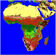
FIGURE 6-4 A much reduced map of the land cover of Africa derived from NOAA AVHRR 1 × 1 km data in 1992-1993 (courtesy U.S. Geological Survey EROS Data Center). The distance (parallel to the Equator) from the tip of Horn of Africa to the west coast off Guinea-Bissau is 7,350 km. Land cover types: pale yellow = barren; light brown = savanna; olive = shrubland; pink = grassland; bright green = deciduous forest; dark green = evergreen forest.
atic observations begun with Terra and maintained on other satellites are planned to continue for at least 15 years.
A major mission of the MODIS sensor is to characterize land cover and global primary productivity (Justice et al., 1998). A year (a complete seasonal cycle) is needed to acquire the raw data for each land-cover dataset. The MODIS land-cover product will identify 17 classes of land cover in the IGBP global vegetation classification scheme7 with a spatial resolution of 1 × 1 km. A global vegetation cover change product is also being developed at a spatial resolution of 250 × 250 m. MODIS data products are being released sequentially, with products for Africa available shortly.
NASA’s MODIS science team is engaging African scientists through networks including the Miombo Network (Chapter 7). Additionally, NASA science campaigns such as Safari2000 are working to put MODIS data in the hands of scientists.
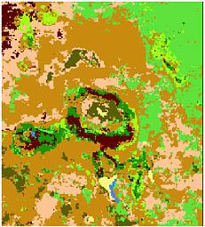
FIGURE 6-5 Full resolution land-cover map of the area centered on Mount Kilimanjaro derived from NOAA AVHRR 1 × 1 km data in 1992-1993 (courtesy U.S. Geological Survey EROS Data Center). The width of the depicted area is 190 km. Land-cover types: pale yellow = barren; light brown = savanna; olive = shrubland; pink = grassland; bright green = deciduous forest; dark green = evergreen forest; red = developed; dark brown = cropland or pasture; pale green = cropland or woodland; blue = water.
Land-Cover Data Source C: Landsat Data
Landsat data have spatial resolutions ranging from 15 × 15 m (Enhanced Thematic Mapper Plus–ETM+) to 79 × 79 m (Multi-Spectral Scanner) (Chapter 5; Annex Box 5-3). As such, Landsat data contain much more spatial information than either AVHRR or MODIS data. The visible, near-infrared, and middle-infrared Landsat Thematic Mapper bands are particularly useful for many vegetation-mapping applications. Landsat data, however, are costly and therefore inaccessible to many potential users unless the data have been purchased, and appropriate sharing arrangements negotiated by a government agency (e.g., NASA [Chapter 5] and NIMA [see below]) or other organizations (e.g., U.N. Food and Agriculture Organization [FAO] [see below]). The tradeoffs between AVHRR or MODIS and Landsat data are primarily between spatial resolution and cost of repeated data collection for change detection.
EarthSat GeoCover Land-Cover Data
In 1999 Earth Satellite Corporation began preparing a Landsat-based land-cover database called “GeoCover-Land
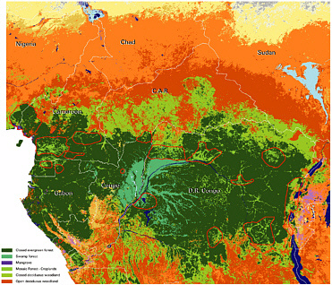
FIGURE 6-6 Forest cover for central Africa and deforestation hot spots (areas circled in red) between 1992 and 1994 derived from NOAA AVHRR data (courtesy of the Tropical Ecosystem Environment Observation by Satellite group). The width of the depicted area is 2,500 km.
Cover” for NIMA (Earth Satellite, 2002). The database for Africa has been completed.8 For example, a land-cover map of the area centered on Mount Kilimanjaro in East Africa is shown in Figure 6-8. This product was produced from EarthSat’s GeoCover-Ortho product (Figure 5-2). The database has a spatial resolution of 30 × 30 m, and contains 13 land-cover classes of Earth’s land areas. EarthSat is also processing global frames of Landsat Multi-Spectral Scanner data obtained during the 1970s and global frames of Landsat TM data obtained in the late 1990s and early 2000s.
Africover Land-Cover Mapping Project
Initiated in 1996, FAO’s Africover project responded to national requests for assistance in obtaining reliable geographically referenced information on natural resources at national and regional scales. The principal sources of data for the project are Landsat 5 Thematic Mapper and Landsat Multi-Spectral Scanner satellite images. The project aims to create two databases for Africa: one a digital land-cover database, the other a geographic database (including roads and hydrography), at a scale of 1:200,000 (1:100,000 for small countries and specific areas) (FAO, 2002a). The land-cover database can be used for forest and rangeland monitoring, watershed management, biodiversity or climate change studies, and in famine early warning systems.
The first operational module of the Africover initiative covers eastern Africa (including Burundi, Democratic Republic of Congo, Egypt, Eritrea, Kenya, Rwanda, Somalia, Sudan, Tanzania, Uganda). Representing roughly one third of Africa (by area),9 this module began in 1997 with funding from the Italian and U.S. governments.
The Africover initiative differs from other examples of land-cover monitoring described in this report because it involves Africans in many aspects of data processing. The resultant network of scientists and technicians is linking with related initiatives such as the UN program on Global Terres-
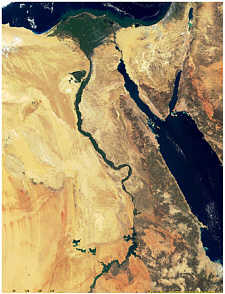
FIGURE 6-7 A land-cover image of the middle and lower Nile from Terra MODIS imagery (courtesy NASA).
trial Observing Strategy (Box 6-1). Land-cover data are derived primarily from on-screen image interpretation in host countries. The land-cover classification is performed manually (as opposed to automatically by a computer) using the “Africover Interpretation and Mapping System,” and the “FAO Land Cover Classification System” (Degregorio and Jansen, 2000). In addition to Landsat data, aerial photography and other geographically referenced data are used during the classification process, and subsequently the accuracy of classifications is verified in the field. The land-cover database is accessible through the Africover Database Gateway (FAO, 2002b).
Land-Cover Data Source D: Declassified Remote Sensor Data
Executive Order Number 12951, issued by President William Clinton on February 22, 1995, directed that
[i]magery acquired by the space-based national intelligence reconnaissance systems known as the Corona, Argon, and Lanyard Missions shall, within 18 months of the date of this order be declassified.
These declassified photographs from U.S. spy satellites are a rich source of historical land-cover and land-use information for many areas in the world (USGS, 1998; Clarke, 1999), including Africa. The satellite photographs may be browsed at no cost using the USGS Global Land Information System and purchased for U.S.$16 to $75 (depending on the size of the photograph) from the USGS EROS Data Center (USGS, 2002b).10 The photographs date from the late 1950s to early 1970s (Peebles, 1997) and often are the earliest satellite photographic record of an area. They are baseline data with which to compare later images for change detection. In an application of some of the hundreds of photographs collected over Africa, Tappan et al. (2000) used Argon and Corona data from 1963 to map historical agricultural practices in Senegal.
Corona, Argon, and Lanyard Images
In 1959 the United States launched Corona, its first reconnaissance satellite (Day et al., 1998). In it’s ninth and first successful mission Corona provided more photographic coverage of the Soviet Union than all previous U-2 spy plane missions combined. Between 1960 and 1972 the spatial resolution of a sequence of Corona satellites improved from 25-40 ft to 4.5-6 ft (Ruffner, 1995; McDonald, 1997) (Table 6-3).11 By 1972 Corona missions, which were followed by the Argon and Lanyard missions, acquired over 800,000 images of Earth (Clarke, 1999) (e.g., Figure 6-9).
Land Cover Data Source E: Space Photography
Since 1961, NASA astronauts have used hand-held cameras to capture approximately 340,000 photographs of Earth (Lulla et al., 1994). Many of these photographs have spatial resolutions similar to Landsat Thematic Mapper and Terra MODIS data.12 They indicate land cover and, in areas with repeat coverage, any change in this parameter since 1961.
Space photography was formalized in the Space Shuttle Earth Observation Photography program and is continued on the International Space Station using digital imaging systems in addition to cameras. Images with a spatial resolution
|
BOX 6-1 The Global Observations of Forest–Global Observations of Land Cover Dynamics (GOFC-GOLD) program is an international activity providing space-based and in situ observations of forest and other vegetation cover for (1) sustainable management of terrestrial resources and (2) obtaining an accurate understanding of the terrestrial carbon budget. It operates under the auspices of the U.N. program on Global Terrestrial Observing Strategy. The GOFC-GOLD program works to accomplish its objectives by (1) providing a forum for users of satellite data to discuss their needs and for producers to respond through improvements to their programs; (2) providing regional and global datasets containing information on location of different forest types, major changes in forest cover, and the biological functioning of forests (to help quantify the contribution forests make as absorbers and emitters of greenhouse gases); (3) promoting international networks for data access, data sharing, and collaboration; and (4) stimulating the production of improved datasets. The program is partnered with the FAO and its Africover project, and operates in Africa through two major networks of local participants. One network coordinates scientists from central Africa in the application of remote-sensing data for forest-cover change analysis and methods for measuring and inventorying forest resources. In southern Africa the program is implemented through collaborative links with the Miombo Network (Chapter 7), a network of scientists in the region focused on fire detection and land-use and ad cover change. The GOFC-GOLD implementation strategy is to demonstrate operational forest monitoring at regional and global scales by conducting pilot projects and developing prototype products within three themes: (1) forest cover characteristics and changes, (2) forest fire monitoring and mapping, and (3) forest biophysical processes. |
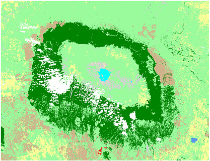
FIGURE 6-8 A land-cover map of Mount Kilimanjaro from the EarthSat GeoCover land-cover mapping project. The map contains 13 classes and was derived from Landsat Thematic Mapper imagery obtained in the early 1990s. Compare this map with the original imagery found in Figure 5-2 (courtesy of Earth Satellite Corporation). The width of the depicted area is 110 km. Dark greens represent the most dense vegetation, pale greens are sparse vegetation, yellows are no vegetation, and browns are croplands.
TABLE 6-3 Summary of Declassified Satellite Missions
|
Orbital Satellite System |
Dates of Operation |
Ground Resolution |
Frames |
|
KH-1 (Single camera) |
June 1959-September 1960 |
25-40 ft. |
1,432 |
|
KH-2 (Single camera) |
October 1960-October 1961 |
25-40 ft. |
7,246 |
|
KH-3 (Single camera) |
August 1961-January 1962 |
25-40 ft. |
9,918 |
|
KH-4 (2 cameras) |
February 1962-December 1963 |
25-40 ft |
101,743 |
|
KH-4A (2 cameras) |
August 1963-August 1969 |
9 ft |
517,688 |
|
KH-4B (2 cameras) |
September 1967-May 1972 |
4.5-6 ft |
188,526 |
|
KH-5 (Global coverage mapping camera) |
February 1961-August 1964 |
460 ft |
38,578 |
|
KH-6 (Panoramic camera) |
July 1963 |
6 ft |
< 910 |
|
SOURCE: Ruffner (1995); McDonald (1997); USGS (1998). |
|||
of 6 × 6 m are being obtained from the International Space Station (Robinson and Evans, 2002). Approximately 14 percent of NASA’s space shuttle photographs cover parts of Africa (Figures 6-10 and 6-11). The photographs are routinely digitized and are in the public domain. NASA’s Johnson Space Center maintains all cataloged space shuttle Earth photography, and digital files (in compressed format) of all the photographs may be accessed through the following web sites: <http://earth.jsc.nasa.gov> or <http://eol.jsc.nasa.gov>. Slides, prints, or high-resolution uncompressed digital files are available for the cost of processing.
FIGURE 6-9 A much reduced photomosaic of Africa produced from Argon (KH-5) photography obtained from 1961 to 1964 (courtesy U.S. Geological Survey and Keith Clarke, Project Corona at the University of California at Santa Barbara). The distance (parallel to the Equator) from the tip of the Horn of Africa to the west coast off Guinea-Bissau is 7,350 km.
The Future of Land-Cover Data Sources for Africa
There are low-cost sources of coarse and medium spatial resolution land-cover information for Africa. These come from sensors that include AVHRR (1 × 1 km), MODIS (1 × 1 km to 250 × 250 m), and Landsat satellite sensors (79 × 79 m to 15 × 15 m). The resultant datasets include Global Land Cover (AVHRR), TREES (AVHRR), GeoCover Land Cover (Landsat), and Africover (Landsat). Such datasets are valuable resources for natural resource management and development planning in rural areas. Similar datasets can be constructed in the future for change detection as long as there is continued flow of data from AVHRR, MODIS, and Landsat (or their equivalents).
Without some way to assure data continuity (NRC, 1995), investments by development organizations in training and capacity building will be less useful than they could be. And without assurances that these investments will be useful in the future, it will be more difficult for African governments to invest in their own capacity and infrastructure. Changes in data access policy, data cost, or the elimination of an observation program create uncertainties about long-term benefits of international programs to Africans.
There are two areas in particular in which U.S. government agencies should contribute to data continuity.
-
Until at least 2018 NASA, NOAA, and DOD should carry out their plan for the National Polar-orbiting Operational Environmental Satellite System to ensure that it supplies relatively coarse spatial and high temporal frequency observations (such as the AVHRR follow-on) that are necessary for a multitude of applications in Africa and elsewhere.
-
NASA and USGS should take measures to ensure that the Landsat data continuity mission(s) provides long-term continuous data, perhaps through making the Landsat program an operational system for land observations, to support sustainable
-
development and natural resource management in Africa and elsewhere. NASA should also ensure that sensors on its Terra and Aqua satellites (e.g., MODIS, ASTER, AMSR-E) continue to provide data for meteorological and land observation applications.
Declassified spy satellite images (e.g., Corona, Argon, Lanyard) and space photography are sources of early (1960s onward) land-cover information against which later sources can be compared for change detection. What is lacking is a low-cost source of very high spatial resolution, up-to-date imagery for urban areas in Africa. A number of Agenda 21 issues center on urban areas, and “image grants” would help to inventory and map the continually changing characteristics of urban infrastructures. Therefore, USAID should consider purchasing very high spatial resolution images (i.e., < 1 × 1 m) on a regular basis (at 5 to 10 year intervals) for urban areas in Africa and donating them to African organizations to ensure continuity of the data source and change detection. The imagery might include airborne analog or digital photography or satellite-derived high-resolution imagery. The areas surveyed could be requested by African organizations on the basis of importance of problem and technical and organizational capacity to use the data. One model for this concept is the U.S. Science Data Buy (Box 5-3).
THE CONDITION OF VEGETATION AND HYDROLOGIC RESOURCES
Measurements of the condition of vegetation, soil, and water resources (biophysical measurements) are needed to
FIGURE 6-10 The geographic distribution of 54,866 space shuttle photographs obtained over Africa prior to 2002 (courtesy Kamlesh Lulla, NASA Johnson Space Center). The distance (parallel to the Equator) from the tip of Horn of Africa to the west coast off Guinea-Bissau is 7,350 km.
FIGURE 6-11 Natural color space shuttle photography of Mount Kilimanjaro in Tanzania (courtesy Kamlesh Lulla, NASA Johnson Space Center). The width of the depicted area is 280 km.
address many environmental and human-induced challenges. For example, these data are pertinent to Agenda 21 issues, including integrated planning and management of land resources, combating deforestation, combating desertification and drought, and promoting sustainable agriculture and rural development (Table 2-5). This section examines the capability of remote-sensing technology to measure (1) vegetation condition, including fire, and (2) rainfall.
Vegetation Condition
The health and productivity of African ecosystems (e.g., forests, rangeland, and cropland) can be measured using vegetation indexes such as the Normalized Difference Vegetation Index, the Enhanced Vegetation Index, the Leaf Area Index, and Fraction of Photosynthetically Active Radiation. Additionally, the occurrence of vegetation on fire can be detected remotely.
Vegetation Indexes
Normalized Difference Vegetation Index
The Normalized Difference Vegetation Index (NDVI)13 is used routinely to assess vegetation condition (e.g., Tappan et al., 1992). The NDVI indicates the amount and vigor of vegetation (Prince and Justice, 1991; Tucker et al., 1991; ADDS, 2002), pointing to potential food security problems and drought. NDVI is derived (Annex Box 6-5) using data from NOAA’s AVHRR sensor (Annex Boxes 6-2 and 6-3) and the European METEOSAT remote-sensing system.
The Famine Early Warning System Network (FEWS NET) uses NDVI to determine the distribution of vegetation condition across Africa every 10 days (Figure 6-12). NDVI images are used to contrast the current condition of vegetation with that of previous times to detect anomalies that could guide famine relief efforts.
FEWS NET has built a valuable archive of NDVI in Africa over the period from 1982 to present. The archived data are not without flaws, however (Box 6-2). The planned National Polar-orbiting Operational Environmental Satellite System (NPOESS) (Annex Box 6-3) will carry an improved version of the AVHRR sensor that should solve some of the problems working with NOAA AVHRR imagery. FEWS NET NDVI data are distributed to the public through the U.S. Geological Survey’s Africa Data Dissemination Service (ADDS, 2002).
Enhanced Vegetation Index
The Enhanced Vegetation Index is derived from atmospherically corrected MODIS hyperspectral data from NASA’s Terra satellite (Figure 6-13) (Annex Box 6-4). MODIS data have higher spatial resolution (up to 250 × 250 m) than AVHRR data and greater spectral sensitivity.
Leaf-Area Index and Fraction of Photosynthetically Ac tive Radiation
The interaction of sunlight with a forest canopy or other vegetation influences climate. Knowing how much light is absorbed and distributed among the canopy, understory, and ground reveals the functional health and productivity of forests, rangelands, and croplands, and improves predictions of energy flow between the land surface and the atmosphere.
Leaf Area Index (LAI) and Fraction of Photosynthetically Active Radiation (FPAR) measurements indicate the green leaf area and how much sunlight the leaves are absorbing. Therefore, they aid in understanding interactions of sunlight with vegetation. For example, LAI and FPAR can be used to assess the grazing potential of rangelands. Both indexes can be derived from MODIS satellite imagery (Annex Box 6-4) (Knyazikhin, 2002) (Figure 6-14). Daily measurements are combined at weekly intervals into maps that show leaf area and absorbed sunlight for every square kilometer of Earth’s land surface during the period. These data products are available less than one month after collection (NASA, 2002a).
Remote Detection of Fire
Naturally induced (e.g., by lightening) and human-induced fires can be remotely detected. Two sources of data for fire detection are the Defense Meteorological Satellite
|
13 |
Annex Box 6-5 contains more details on the NDVI calculation. |
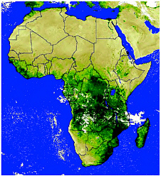
FIGURE 6-12 Ten-day composite Normalized Difference Vegetation Index (NDVI) map of Africa derived from NOAA AVHRR imagery in February 2002 (dekad 2). The image is composed of 8 × 8 km pixels. The darker colors indicate denser vegetation (courtesy U.S. Geological Survey EROS Data Center International Program, FEWS NET, USAID, NOAA, and Global Inventory Monitoring and Modeling Studies at NASA). The distance (parallel to the Equator) from the tip of the Horn of Africa to the west coast off Guinea-Bissau is 7,350 km.
|
BOX 6-2 FEWS NET is one of the most successful demonstrations of the value of remotely sensed imagery in Africa. However, AGRHYMET in Niger found the quality of the NDVI data to be inconsistent, rendering them unreliable for desertification monitoring and drought early warning. Problems included imprecise geographic registration (up to 5 km off) temporal gaps (with only the growing season covered in most years), and anomalously low NDVI values. Consequently, AGRHYMET requested technical assistance from the U.S. government (USGS and NASA) to correct its NDVI archive and improve its operational NDVI capability. A long-term, reliable NDVI archive will permit AGRHYMET to conduct detailed analyses of desertification, one of its obligations under the U.N. Convention to Combat Desertification, in addition to improving early warning information routinely distributed by AGRHYMET. AGRHYMET staff conduct the computer processing with onsite assistance from USGS and NASA staff. Subsequently, USGS and AGRHYMET are posting the data on their Web sites for public access (<http://edcintl.cr.usgs.gov/adds/index.php> and <http://www.agrhymet.ne>, respectively). |
FIGURE 6-13 Enhanced Vegetation Index map of Africa derived from MODIS hyper-spectral imagery collected between February 21 and April 21, 2001 (courtesy of NASA). The darker colors represent denser vegetation. The distance (parallel to the Equator) from the tip of the Horn of Africa to the west coast off Guinea-Bissau is 7,350 km.
Program’s (DMSP) Operational Linescan System products (Annex Box 5-6) (Cahoon et al., 1992), and NASA’s MODIS sensor (Annex Box 6-4).
The DMSP fire products are generated by overlaying the lights detected from a single orbit on a reference database of stable lights (e.g., city lights) to reveal new sources of light, such as fires (Elvidge et al., 2002) (Figure 5-12). The MODIS products include (1) surface temperature (fires are hot!) and (2) fire occurrence and burn scars (e.g. Figure 6-15) (NASA, 2002b). Fire occurrence data are produced daily (or, for rapid-response products, more frequently).
Rainfall
The livelihoods of the majority of Africans are intimately related to rainfall, which varies greatly from year to year and from place to place. Research over the last three decades has made it possible to obtain rainfall rates using remote passive microwave sensors (Annex Box 6-6). Two sources of rainfall data are the DMSP Special Sensor Microwave/Imager (SSM/I) and NASA and the National Space Development
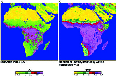
FIGURE 6-14 (a) Leaf Area Index and (b) Fraction of Photosynthetically Active Radiation maps of Africa derived from MODIS hyperspectral imagery (courtesy of NASA). The distance (parallel to the Equator) from the tip of the Horn of Africa to the west coast off Guinea-Bissau is 7,350 km.
Agency of Japan’s Tropical Rainfall Measuring Mission (TRMM) (Hou et al., 2001).14
Rainfall Detection by the Defense Meteorological Satellite Program
NOAA developed methods for estimating rainfall rates from the SSM/I onboard DMSP satellites through calibration with surface rainfall measurements. Since July 1987, global monthly rainfall data have been produced in 100 × 100 km and 250 × 250 km grids (Ferraro, 1997; Li et al., 1998). These data are available from the National Climatic Data Center Satellite Data Services Division at a cost per orbit of $8 plus cost of media (from <dmsp@ngdc.noaa.gov>).
As a contribution to the USAID-funded FEWS NET, NOAA’s Climate Prediction Center also developed a program for rainfall estimation for Africa. The program uses data from numerous sources, including thermal infrared imagery from the European geostationary meteorological satellite (METEOSAT), passive microwave data from the Advanced Microwave Sounding Unit on NOAA’s Polar-orbiting Operational Environmental Satellites (POES), DMSP SSM/I data, and rain gauge data retrieved with the World Meteorological Organization Global Telecommunication System. All of this information is processed and made available daily and in 10-day, monthly, and seasonal summaries (Climate Prediction Center, 2002)
Rainfall Detection by the Tropical Rainfall Measuring Mission
The TRMM was launched in 1997 and continues today (Annex Box 6-6). The mission’s passive microwave sensor (the TRMM Microwave Imager, TMI) supplies quantitative rainfall information at a spatial resolution of 5 to 45 km. Figure 6-16 depicts a one-month average of rainfall measurements acquired during January of 1998
A new series of experimental near-real-time precipitation estimates is available for latitudes between 50 degrees north and 50 degrees south within about six hours of observation. The data products include a TRMM-calibrated merger of all available TMI and SSM/I precipitation estimates, available in three-hour accumulations (NASA, 2002c).
FIGURE 6-15 Results of querying the MODIS Land Science Team Fire Web site (NASA, 2002b). The image shows fires (in red) during October 2001 overlaid on a vegetation surface reflectance image (courtesy NASA).
DATA FOR MANAGING HUMAN HEALTH
Human health is a major challenge for African societies and economies. Disease disrupts families, education, and the workforce. Of the 40 million people worldwide who are infected with AIDS or HIV, about 25 million are in Africa, and the number of Africans infected each year from AIDS-related tuberculosis is about 10 million (WHO, 2001). Additionally, there are approximately 110 million clinical cases of malaria worldwide per year, and over 80 percent of these occur in sub-Saharan Africa.
Although raw numbers on disease incidence are valuable to decision-makers, the distribution and rate of diffusion of disease relates to complex interactions among multiple factors, many of which are geographic (e.g., climate, vegetation, topography, elevation, demography, poverty). A geographic information system facilitates the integration and analysis of these diverse data layers (e.g., Box 6-3) and planning for distribution of medical supplies, assistance, and food. GIS also is a tool for addressing the spread of diseases.
Many of the factors that influence the spread of disease can be mapped using remotely sensed data. NASA’s Center for Health Applications of Aerospace Related Technologies (CHAART) generates data that illustrate links between disease and such factors as vegetation that can be remotely sensed (Table 6-4). CHAART evaluates existing and planned remote sensor systems enabling human health scientists to determine relevant data for epidemiological, entomological, and ecological research. It also develops remote-sensing-based models of disease transmission risk (Beck et al., 2000). CHAART conducts several research projects in Africa that apply remotely sensed data (mainly from Landsat Thematic Mapper images) to monitor and predict disease (e.g., Table 6-5).
People are using remotely sensed images and data in GISs for monitoring and evaluating factors associated with disease. They are using satellite instruments for mapping, sur-
|
BOX 6-3 Schistosomiasis is a snail-borne disease. The ability to identify this health threat and monitor the disease enables public health officials to take preventive measures (e.g., vector control). Often the identification of infected human hosts and vector snails depends on labor-intensive ground survey methods for data collection. This method introduces inconsistencies that lead to inaccuracies. By contrast, satellite remote-sensing methods make it possible to obtain standardized data over large geographic areas (Abdel-Rahman et al., 2001). As a result there is increasing interest in these methods for health-related applications. Remotely sensed data (from NOAA’s AVHRR sensor) are being used in spatial decision-support systems to manage control programs for schistosomiasis in Africa. These efforts include a program in the Lake Victoria region building on Malone et al.’s (2001) work in East Africa. The Lake Victoria program also benefits from experiences during a four-year effort in Egypt in which a schistosomiasis risk model was developed for the Ministry of Health (Abdel-Rahman et al., 2001). The model enables the ministry to make more accurate decisions in its program of controlling the spread of schistosomiasis. This GIS-based model, along with the data, constitutes the decision-support system. Two sources of remotely sensed data were used. First, diurnal temperature range and a vegetation index (NDVI) were estimated from NOAA AVHRR data. Second, Landsat Thematic Mapper imagery was used to generate a base map. These data were integrated in a GIS with a database of schistosomiasis prevalence, ground survey results on soil type and salinity, and thematic information from 1:250,000 and 1:10,000 paper maps. From this study it became clear that remote-sensing could extend the capability of the ministry to manage schistosomiasis in Egypt. |
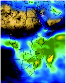
FIGURE 6-16 Average rainfall during January 1998 from the Tropical Rainfall Measuring Mission passive microwave sensor. Low rainfall is indicated by light blue and heavy rainfall by orange and red (courtesy of NASA and the National Space Development Agency of Japan).
veillance, prediction, and control of disease transmission. Moreover, they draw links between environmental variables and disease. As the availability of and access to data and decision-support tools increases, geographic information will become more prominent in efforts to control disease and protect human health in Africa.
COORDINATION AMONG DATA PRODUCERS AND USERS
Moving beyond the current state of the art in the application of geographic data in Africa will require greater attention to coordination among data providers, development assistance agencies, and the science community and end-users in Africa. Already the requirements for the next generation of remote-sensing systems are being defined or developed in many parts of the world, yet there appears to be little dialog between the space agencies and the development assistance agencies, and even less input from potential end users of the data in Africa. Few of the geographic data generation programs now in place have a formal process by which lessons learned in the application of existing data for decision-making are fed back into the definition of future observation and data system requirements, particularly in government science agencies. Consequently, data providers, U.S. government agencies, and partners should work closely with African organizations to define and integrate the data needs of African users into future data-gathering missions, and to maximize efficiency of new programs through a coordinated approach. As an added benefit, this dialog will allow users to express their data processing needs.
TABLE 6-4 Links Between Disease and Factors That Can Be Remotely Sensed
|
Factor |
Disease |
Mapping Opportunity |
|
Vegetation/crop type |
Malaria |
Breeding/resting/feeding habitats; crop pesticide vector resistance |
|
|
Schistosomiasis |
Agricultural association with snails; use of human fertilizers |
|
Trypanosomiasis |
Glossina habitat (forests, around villages, depending on species) |
|
|
Yellow fever |
Reservoir (monkey) habitat |
|
|
Vegetation green-up |
Malaria |
Timing of habitat creation |
|
|
Rift Valley fever |
Rainfall |
|
Trypanosomiasis |
Glossina survival |
|
|
Deforestation |
Malaria |
Habitat creation (for vectors requiring sunlit pools); habitat destruction (for vectors requiring shaded pools) |
|
|
Yellow fever |
Migration of infected human workers into forests where vectors exist; migration of disease reservoirs (monkeys) in search of new habitat |
|
Forest patches |
Yellow fever |
Reservoir (monkey) habitat; migration routes |
|
Flooding |
Malaria |
Mosquito habitat |
|
|
Rift Valley fever |
Breeding habitat for mosquito vector |
|
Schistosomiasis |
Habitat creation for snails |
|
|
Permanent water and wetlands |
Filariasis |
Breeding habitat for Mansonia mosquitoes |
|
|
Malaria |
Breeding habitat for mosquitoes |
|
Schistosomiasis |
Snail habitat |
|
|
Canals |
Malaria |
Dry season mosquito-breeding habitat; ponding; leaking water |
|
|
Schistosomiasis |
Snail habitat |
|
SOURCE: Adapted from Beck et al. (2000). |
||
TABLE 6-5 Research Using Remotely-Sensed Data to Map Disease Vectors
|
Disease |
Vector |
Location |
Sensora |
Reference |
|
Dracunculiasis |
Cyclops spp. |
Benin |
Landsat TM |
Clarke et al, 1990 |
|
|
Cyclops spp. |
Nigeria |
Landsat TM |
Ahearn and De Rooy, 1996 |
|
Filariasis |
Culex pipiens |
Egypt |
AVHRR |
Hassan et al., 1998a |
|
|
Culex pipiens |
Egypt |
Landsat TM |
Hassan et al., 1998b; Cross et al., 1996 |
|
Malaria |
Anoepheles spp. |
Gambia |
AVHRR, Meteosat |
Thomson et al., 1997; Beck et al., 1994 |
|
|
Kenya |
RADARSAT-1 |
Kaya et al., 2002 |
|
|
Rift Valley fever |
Aedes & Culex. spp |
Kenya |
AVHRR |
Linthicum et al., 1990; Pope et al., 1992 |
|
|
Culex. spp. |
Kenya |
Landsat TM, Synthetic Aperture Radar |
Linthicum et al., 1994 |
|
Culex. spp. |
Senegal |
SPOT, AVHRR |
Malone et al., 1994 |
|
|
Schistosomiasis |
Biomphalaria spp. |
Egypt |
AVHRR |
Rogers, 1991 |
|
Trypanosomiasis |
Glossina spp |
Kenya, Uganda |
AVHRR |
Kitron et al., 1996 |
|
|
Glossina spp |
Kenya |
Landsat TM |
Rogers and Randolph, 1991 |
|
Glossina spp |
West Africa |
AVHRR |
Rogers and Williams, 1993 |
|
|
Glossina spp |
Africa |
AVHRR |
Robinson et al., 1997 |
|
|
Glossina spp |
Southern Africa |
AVHRR |
CEOS, 1995 |
|
|
aTM = Thematic Mapper; AVHRR = (NOAA’s) Advanced Very High Resolution Radiometer; SPOT = Système Pour l’Observation de la Terre. SOURCE: Adapted from Beck et al. (2000) |
||||
For example, the option for users in developing countries to obtain geographic data in processed or raw form from government and private data sources will allow flexibility in the required level of geospatial capacity to use the data.
SUMMARY
Many types of thematic geographic data such as land cover, biophysical data, and some data for managing human health are, with the exception of very high spatial resolution urban land-cover data, available at low cost for addressing Agenda 21 issues in Africa. There are many existing applications of these data. Continuity of the data sources or their equivalents, options for raw and processed data, and coordination among data providers and users are crucial for continued and expanded use of geographic data for sustainable development in Africa.
The next chapter explores how people manage, analyze, and subsequently integrate geographic data into the decision-making process.
REFERENCES
Abdel-Rahman, M. S., M. M. El-Bahy, J. B. Malone, R. A. Thompson, and N. M. El Bahy. 2001. Geographic information systems as a tool for control program management for schistosomiasis in Egypt. Acta Tropica 79:49-57.
Achard, F., H. Eva., A. Glinni, P. Mayaux, T. Richards, and H. Stibig (eds). 1998. Identification of Deforestation Hot Spot Areas in the Humid Tropics. TREES Publications Series B. Research Report no. 4. Ispra, Italy: Joint Research Centre, European Commission.
ADDS (Africa Data Dissemination Service). 2002. Africa Data Dissemination Service homepage. Available at <http://edcintl.cr.usgs.gov/adds/NDVIPaper.php>. Accessed June 27, 2002.
Ahearn, S. C., and C. De Rooy. 1996. Monitoring the effects of dracunculiasis remediation on agricultural productivity using satellite data. International Journal of Remote Sensing 17:917-929.
Anderson, J. R., E. E. Hardy, J. T. Roach, and R. E. Witmer. 1976. A land use and land cover classification system for use with remote sensor data. U.S. Geological Survey Professional Paper 964. Washington, DC: U.S. Government Printing Office.
Beck L. R., M. H. Rodríguez, S. W. Dister, A. D. Rodríguez, E. Rejmánková, and A. Ulloa. 1994. Remote sensing as a landscape epidemiologic tool to identify villages at high risk for malaria transmission. American Journal of Tropical Medicine Hyg. 51:271-280.
Beck, L. R., B. M. Lobitz, and B. L. Wood. 2000. Remote Sensing and Human Health: New Sensors and New Opportunities, Emerging Infectious Diseases. Available at <http://www.cdc.gov/ncidod/eid/vol6no3/beck.htm>. Accessed June 5, 2002.
Belward, A.S. (ed). 1996. The IGBP-DIS Global 1 km Land Cover Data Set (DISCover): Proposal and Implementation Plans. IGBP-DIS Working Paper No. 13. Toulouse, France: IGBP-DIS Office. Meteo-France.
Cahoon, D. R. Jr., B .J. Stocks, J. S. Levine, W. S. Cofer, III, and K. P. O’Neill. 1992. Seasonal Distribution of African Savanna Fires. Nature 359:812-815.
CEOS (Committee on Earth Observation Satellites). 1995. Coordination for the Next Decade (1995 CEOS Yearbook). European Space Agency. Smith System Engineering Ltd, UK.
Clarke, K. 1999. Project Corona, sponsored by the National Science Foundation, Santa Barbara: University of California Santa Barbara. Available at <http://www.geog.ucsb.edu/~kclarke/Corona/Corona.html>. Accessed June 27, 2002.
Clarke, K., J. Osleeb, J. Sherry J. Meert, R. Larsson. 1990. The Use of Remote Sensing and Geographic Information Systems in UNICEF’s Dracunculiasis (Guinea worm) Eradication Effort. Prev. Vet. Med.11: 229-235.
Climate Prediction Center. 2002. Climate Prediction Center Africa Data Archive. Available at <http://www.cpc.ncep.noaa.gov/products/fews/data.html>. Accessed July 12, 2002.
Cross, E. R., W. W. Newcomb, and C. J. Tucker. 1996. Use of weather data and remote sensing to predict the geographic and seasonal distribution of Phlebotomus papatasi in Southwest Asia. American Journal of Tropical Medicine and Hygiene 54:530-536.
Day, D. A., J. M. Logsdon, and B. Latell (eds.) 1998. Eye in the Sky: The Story of the Corona Spy Satellites, History of Aviation Series, Washington, DC: Smithsonian Institution.
Degregorio, A. and L. J. M. Jansen. 2000. Land Cover Classification System—LCCS, Rome: U.N. Food and Agriculture Organization.
Dickinson, R. E., A. Henderson-Sellers, P. J. Kennedy, and M. F. Wilson. 1986. Biosphere-atmosphere transfer scheme (BATS) for the NCAR community climate model, Boulder, CO: NCAR Technical Note NCAR/ TN275+STR.
Earth Satellite. 2002. GeoCover—Global Land Cover Database. Rockville, MD: Earth Satellite, Inc. Available at <http://www.earthsat.com>. Accessed June 5, 2002.
Elvidge, C. D., K. B. Baugh, V. R. Hobson, E. A. Kihn, and H. W. Kroehl. 2002. Detection of Fires and Power Outages At Night Using DMSP-OLS Data. Available at <http://www.ngdc.noaa.gov/dmsp/fires/fires_desc.html>. Accessed June 5, 2002.
Engman, E. T. and R. J. Gurney. 1991. Remote Sensing in Hydrology, New York: Chapman and Hall.
Eva, H. D., A. Glinni, P. Janvier, and C. Blair-Myers. 1998. Vegetation Map of South America at 1:5,000,000. TREES Publications Series D2. Luxembourg, European Commission, EUR 18658 EN.
FAO (U.N. Food and Agriculture Organization). 2002a. Africover: Land cover assessment based on remote sensing for the whole African continent. Available at <http://www.africover.org/General%20overview.htm>. Accessed on June 28, 2002.
FAO. 2002b. Africover Database Gateway. Available at http://www.africover.org/adg.htm. Accessed July 12, 2002.
Ferraro, R. R. 1997 SSM/I Derived Global Rainfall Estimates for Climatological Applications. Journal of Geophysical Research 102(16):715-716.
Geist, H. J. and E. F. Lambin. 2002. Proximate Causes and Underlying Driving Forces of Tropical Deforestation. BioScience 52(2): 143-150.
Hassan A. N., L. R. Beck, and and S. Dister. 1998a. Prediction of villages at risk for filariasis transmission in the Nile Delta using remote sensing and geographic information system technologies. J. Egypt. Soc. Parasitol. 28:75-87.
Hassan A. N., S. Dister, and L. Beck. 1998b. Spatial analysis of lymphatic filariasis distribution in the Nile Delta in relation to some environmental variables using geographic information system technology. J. Egypt. Soc. Parasitol. 28:119-131.
Hou, A. Y., S. Zhang, A. da Silva, W. Olson, C. Kummerow, and J. Simpson. 2001. Improving Global Analysis and Short-range Forecasts using Rainfall and Moisture Observations Derived from TRMM and SSM/I Passive Microwave Sensors. Bulletin of the American Meteorological Society 82. pp. 659-680.
IGBP-IHDP. 2002. Land Use and Land Cover Change (LUCC): A Joint IGBP- IHDP Research Project. Available at <http://www.geo.ucl.ac.be/LUCC/scienceplan/scienceplan.html>. Accessed June 5, 2002.
Jensen, J. R. 1996. Introductory Digital Image Processing: A Remote Sensing Perspective. Saddle River: Prentice-Hall, Inc.
Jensen, J. R. 2000. Remote Sensing of the Environment: An Earth Resource Perspective. Saddle River: Prentice-Hall, Inc.
Jensen, J. R. and D. J. Cowen. 1999. Remote Sensing of Urban/Suburban Infrastructure and Socio-Economic Attributes. Photogrammetric Engineering and Remote Sensing. 65:611-622.
Justice, C., E. Vermote, J. Townshend, R. Defries, D. Roy, D. Hall, V. Salomonson, J. Privette, G. Riggs, A. Strahler, W. Lucht, R. Myneni, Y. Knjazihhin, S. Running, R. Nemani, Z. Wan, A. Huete, W. van Leeuwen, R. Wolfe, L. Giglio, J. Muller, P. Lewis, and M. Barnsley. 1998. The Moderate Resolution Imaging Spectroradiometer (MODIS): Land remote sensing for global change research. IEEE Trans. Geosci. Remote Sens. 36:1228-1249.
Kaya, S., T. Pultz, J. Beier, and E. Mushinzimana. 2002. The use of radar remote sensing for identifying environmental factors associated with malaria risk in coastal Kenya. Available at <http://www.pcigeomatics.com/tech-papers/igarss02_kaya_paper.pdf>. Accessed May 31, 2002 .
Kimes, D. S., B. N. Holben, C. J. Tucker, and W. W. Newcomb. 1984. Optimal Directional View Angles for Remote-Sensing Missions. International Journal of Remote Sensing 5:887-908.
Kitron, U., L. H. Otieno, L. L. Hungerford, A. Odulaja, W. U. Brigham, O. O. Okello, M. Joselyn, M. M. Mohamed-Ahmed, and E. Cook. 1996. Spatial analysis of the distribution of tsetse flies in the Lambwe Valley, Kenya, using Landsat TM satellite imagery and GIS. J. Animal Ecol. 65:371-380.
Knyazikhin, Y. 2002. MODIS Instrument on NASA’s Terra Satellite Improves Global Vegetation Mapping, Makes New Observations Possible. NASA New Archive, Release 01-126, December 20, 2001, Available at <http://earthobservatory.nasa.gov/Newsroom/NasaNews/2001/200112206806.html>. Accessed May 31, 2002.
Lambin, E. F. and H. J. Geist, 2001. Global Land-Use and Land-Cover Change: What Have We Learned So Far? Global Change Newsletter (46):27-30. Available at <http://www.igbp.kva.se>. Accessed June 5, 2002.
Li, Q., R. Ferraro, and N. C. Grody. 1998. Detailed Analysis of the Error Associated with the Rainfall Retrieved by the NOAA/NESDIS SSM/I Rainfall Algorithm: Part 1. Journal of Geophysical Research. 103(11): 419-427.
Linthicum K., C. Bailey, C. Tucker, K. Mitchell, T. Logan, and F. Davies. 1990. Applications of polar-orbiting, meteorological satellite data to detect flooding in Rift Valley Fever virus vector mosquito habitats in Kenya. Med. Vet. Entomol. 4:433-438.
Linthicum, K., C. Bailey, C. Tucker, S. Gordon, T. Logan, and C. Peters. 1994. Man-made ecological alterations of Senegal River basin on Rift Valley Fever transmission. Sistema Terra. Vol 3, pp. 45-47.
Loveland, T., B. Reed, J. Brown, D. Ohlen, J. Zhu, L. Yang, and J. Merchant. 2000. Development of a Global Land Cover Characteristics Database and IGBP DISCover from 1-km AVHRR Data. International Journal of Remote Sensing 21(6-7):1303-1330.
Lulla, K., M. Helfer, and D. Holland. 1994. The NASA Space Shuttle Earth Observations Database for Global Change Science. Pp 335-365 in Remote Sensing and Global Climate Change. R. Vaughan and A. P. Cracknell, eds. Heidelberg: Springer-Verlag.
Malone J., O. Huh, D. Fehler, P. Wilson, D. Wilensky, and R. Holmes. 1994. Temperature data from satellite images and the distribution of schistosomiasis in Egypt. Am. J. Trop. Med. Hyg. 50:714-722.
Malone, J., J.Yilma, J. McCarroll, B. Erko, S. Mukaratirwa, and X. Zhou. 2001. Satellite climatology and the environmental risk of Schistosoma mansoni in Ethiopia and east Africa. Acta Tropica 79:59-72
Mayaux, P., E. Janodet, C. Blair-Myers, and P. Legeay-Janvier. 1997. Vegetation Map of Central Africa at 1:5,000,000. TREES Series D: Thematic output No 1. Ispra, Italy: Space Applications Institute, EC-JRC. EUR 17322 EN.
McDonald, R. A. 1997. Corona, Argon, and Lanyard: A Revolution for U.S. Overhead Reconnaissance. Pp 61-79 in Corona: Between the Sun and the Earth. Bethesda, MD: American Society for Photogrammetry and Remote Sensing.
NASA (National Aeronautics and Space Administration). 2002a. MODIS Land Discipline Web site. Available at <http://modis-land.gsfc.nasa.gov/products/products.asp?ProdFamID=5>. Accessed July 12, 2002.
NASA. 2002b. Rationale for the MODIS Fire and Thermal Anomalies Data Products . Greenbelt, MD: NASA Goddard Space Flight Center. Available at <http://modis-fire.gsfc.nasa.gov/rationale/>. Accessed May 31, 2002.
NASA, 2002c. TRMM-Based 3-hr Real-time Rainfall Analyses, Greenbelt, MD: NASA Goddard Space Flight Center, Available at <http://trmm.gsfc.nasa.gov/publications_dir/precipitation_msg.html>. Accessed May 31, 2002.
NRC (National Research Council). 1995. Earth Observations From Space: History, Promise, and Reality. Washington, DC: National Academy Press.
NOAA (National Oceanic and Atmospheric Administration). 2001a. NOAA’s National Environmental Satellite, Data, and Information Service: Economic Value for the Nation. Silver Spring, MD: NOAA. Available at <http://www.nesdis.noaa.gov>. Accessed June 27, 2002.
NOAA. 2001b. National Polar-orbiting Operational Environmental Satellite System (NPOESS). #F90109-99. Washington, DC: NOAA.
Olson, J. S. 1994a. Global Ecosystem Framework: Definitions. USGS EROS Data Center Internal Report. Sioux Falls, SD: USGS.
Olson, J. S. 1994b. Global Ecosystem Framework: Translation Strategy. USGS EROS Data Center Internal Report. Sioux Falls, SD: USGS.
Peebles, C. 1997. The Corona Project: America’s First Spy Satellites. Annapolis, MD: Naval Institute Press.
Pope, K., E. Sheffner, K. Linthicum, C. Bailey, T. Logan, E. Kasischke. 1992. Identification of central Kenyan Rift Valley Fever virus vector habitats with Landsat TM and evaluation of their flooding status with Airborne Imaging Radar. Remote Sensing Environment 40:185-196.
Prince, S. D. and C. O. Justice (eds). 1991. Coarse Resolution Remote Sensing of the Sahelian Environment. International Journal of Remote Sensing. 12: 1133-1421.
Robinson, J. A. and C. A. Evans. 2002. Space Station allows remote sensing of Earth to within six meters. EOS, Transactions, American Geophysical Union 83:185-188.
Robinson, T, D. Rogers, and B. Williams. 1997. Mapping tsetse habitat suitability in the common fly belt of southern Africa using multivariate analysis of climate and remotely sensed data. Med. Vet. Entomol.11: 235-245.
Rogers, D. J. 1991. Satellite imagery, tsetse and trypanosomiasis. Prev. Vet. Med.11:201-20.
Rogers, D. and S. Randolph. 1991. Mortality rates and population density of tsetse flies correlated with satellite imagery. Nature 351:739-741.
Rogers, D. and B. Williams. 1993. Monitoring trypanosomiasis in space and time. Parasitology 106 (Suppl):77-92.
Ruffner, K. C. 1995. CORONA: America’s First Satellite Program. Washington, DC: Central Intelligence Agency.
Running, S., T. Loveland, L. Pierce, R. Nemani, and E. Hunt. 1995. A Remote Sensing Based Vegetation Classification Logic for Global Land Cover Analysis. Remote Sensing of Environment 51:39-48.
Sellers, P. J., D. Randall, G. Collatz, J. Berry, C. Field, D. Dazlich, C. Zhang, G. Collelo, and L. Bounoua. 1996. A Revised Land Surface Parameterization (SiB2) for Atmospheric GCMs—Part I—Model Formulation. Journal of Climate 9:676-705.
Tappan, G., D. Tyler, M. Wehde, and D. Moore. 1992. Monitoring Rangeland Dynamics in Senegal with Advanced Very High Resolution Radiometer Data. Geocarto International 7(1):87-98.
Tappan, G., A. Hadj, E. Wood, and R. Lietzow. 2000. Use of Argon, Corona, and Landsat Imagery to Assess 30 Years of Land Resource Changes in West-Central Senegal. Photogrammetric Engineering and Remote Sensing 6(6):727-735.
Thomson M., S. Connor, P. Milligan, and S. Flasse. 1997. Mapping malaria risk in Africa: What can satellite data contribute? Parasitology Today 13:313-318.
Townshend, J. and D. Skole. 1995. The global 1 km AVHRR data set. Pp 75-82 in Understanding the Terrestrial Environment, Remote Sensing Data Systems and Networks, P. Mather, ed. Chichester, New York: John Wiley and Sons.
TREES (Tropical Ecosystem Environment Observations by Satellite). 2002. Available at http://www.gvm.sai.jrc.it/Forest/defaultForest.htm. Accessed July 12, 2002.
Tucker, C., H. Dregne, and W. Newcomb. 1991. Expansion and Contraction of the Saharan Desert from 1980 to 1990. Science 253:299-301.
USGS (U.S. Geological Survey). 1998. Declassified Intelligence Satellite Photographs. Fact Sheet 090-96. Washington D.: U.S. Geological Survey.
USGS. 2002a. Global Land Cover Characterization Background. Sioux Falls, SD: EROS Data Center, U.S. Geological Survey. Available at<http://edcdaac.usgs.gov/glcc/background.html>. Accessed May 31, 2002.
USGS. 2002b. EROS Data Center homepage. Available at <http://edc.usgs.gov/>. Accessed July 12, 2002.
U.S. Institute for Peace. 2002. Space Aid: Current and Potential Uses of Satellite Imagery in U.N. Humanitarian Organizations. 24 p. Available at <http://www.usip.org/vdi/vdr/12.html>. Accessed May 31, 2002.
WHO (World Health Organization). 2001. Scaling up the Response to Infectious Diseases: A Way Out of Poverty. Available at <http://www.who.int/infectious-disease-report/2002/framesintro.html>. Accessed May 31, 2002.
ANNEX 6
|
ANNEX BOX 6-1 The IKONOS satellite was launched by Space Imaging, Inc., on September 24, 1999 (<http://www.spaceimaging.com>). The satellite has a linear array remote-sensing system that collects 1 × 1 m (0.45-0.90 μm) panchromatic data and four multispectral visible and near-infrared bands (0.45-0.52 μm; 0.52-0.60 μm; 0.63-0.69 μm; and 0.76-0.90 μm) at 4 × 4 m. IKONOS is in a Sun-synchronous orbit 681 km above Earth. It has cross-track and along-track pointing capability and a nominal swath width of 11 km. The Quickbird satellite, launched by DigitalGlobe has a linear array remote-sensing system that acquires 61 × 61 cm spatial resolution panchromatic data (0.45-0.90 μm) and four multispectral visible and nearinfrared bands (0.45-0.52 μm; 0.52-0.60 μm; 0.63-0.69 μm; 0.76-0.89 μm) at 4 × 4 m. It has a swath width of 20-40 km. Prices for standard panchromatic images are $22.50/km and $25/km for multispectral with a minimum order of 64 km2 (<http://www.digitalglobe.com>; <http://www.rsi.ca/products/quickbird/news/hir_qbi_news2_041802.htm>). There are several innovative characteristics associated with these remote-sensing systems.
|
|
ANNEX BOX 6-2 The POES program is a cooperative effort between NASA, NOAA, the United Kingdom, and France. The most valuable POES instrument for Agenda 21 issues is the Advanced Very High Resolution Radiometer (AVHRR). AVHRR data are used to study and monitor vegetation conditions in ecosystems, including forests, tundra, and grasslands. Applications include agricultural assessment and land-cover mapping. AVHRR has a spatial resolution of approximately 1.1 × 1.1 km at the satellite nadir from the nominal orbit altitude of 833 km (517 mi). The AVHRR measures reflected or emitted radiant energy in five spectral bands that vary according to which of nine NOAA AVHRR instruments (numbered by the satellite on which it flies) is being used.
Each satellite orbits Earth 14 times daily and has a swath width for each pass of 2,399 km (1,491 mi). NOAA/NESDIS (National Environmental Satellite, Data, and Information Service) in Suitland, Maryland, receives both worldwide recorded and direct readout AVHRR data from the Wallops Island, Virginia, and Gilmore Creek, Alaska, stations. NOAA/ NESDIS processes, archives, and reproduces the data. POES and its continuation, NPOESS (Annex Box 6-3), have the following launch dates:
SOURCE: NOAA (2001a). |
||||||||||||||||||||||||||||||||||||||||
|
ANNEX BOX 6-3 In 1994 a decision was made to eventually merge the U.S. Department of Defense’s (DOD’s) Defense Meteorological Satellite Program (DMSP) and the NOAA Polar-orbiting Operational Environmental Satellite (POES) system into a single system: the National Polar-orbiting Operational Environmental Satellite System (NPOESS). The system is jointly managed by NOAA, DOD, and NASA to:
NPOESS will provide an operational remote-sensing capability from 2008 to 2018. It consists of two satellites in two orbital planes that will replace the DMSP and POES constellations. NPOESS will also include a European Organization for the Exploitation of Meteorological Satellites (EUMETSAT) instrument called the Meteorological Operational Satellite (METOP). Six NPOESS sensor systems are currently under development (NOAA, 2001b).
SOURCE: NOAA (2001a,b). |
|
ANNEX BOX 6-4 NASA’s Terra satellite is the flagship of the Earth Observing System (EOS). This research satellite was launched on December 18, 1999, into a 705-km Sun-synchronous orbit. It contains five remote-sensing systems: the Advanced Spaceborne Thermal Emission and Reflection Radiometer (ASTER), the Clouds and the Earth’s Radiant Energy System (CERES), the Multi-angle Imaging SpectroRadiometer (MISR), the Moderate Resolution Imaging Spectroradiometer (MODIS), and the Measurements of Pollution in the Troposphere (MOPITT). MODIS began collecting science data on February 24, 2000. It views the entire surface of Earth every one to two days. It has a field of view of ± 55° off-nadir, which yields a large swath width of 2,330 km. MODIS obtains high radiometric resolution images (12 bit) of daylight-reflected solar radiation and day/night thermal emission over all regions of the globe. MODIS’s scanning, imaging radiometer collects data in 36 co-registered spectral bands: 20 bands from 0.4-3 μm and 16 bands from 3-15 μm. MODIS has one of the most comprehensive calibration systems ever flown on a remote-sensing instrument. MODIS’s relatively coarse spatial resolution ranges from 250 × 250 m (bands 1-2) to 500 × 500 m (bands 3-7) and 1 × 1 km (bands 8-36). Consequently MODIS is valuable for regional Earth-resource analyses, especially those dealing with vegetation characteristics and water quality. MODIS data can be used to compute an Enhanced Vegetation Index (EVI), Leaf Area Index (LAI), Fraction of Photosynthetically Active Radiation (FPAR), and surface temperature. There are approximately 40 MODIS data products. These products arise from MODIS Scientific Algorithm Theoretical Basis Documents (ATBD’s) that convert the radiances received by the instrument into geophysical quantities. The following list summarizes some of the major ATBDs associated with MODIS land applications. MODIS Land Algorithm Theoretical Basis Documents (ATBDs)
|
|
ANNEX BOX 6-5 Vegetation indexes from AVHRR data are based on mathematical modeling of spectral reflectance measurement in various parts of the electromagnetic spectrum. Most indexes make maximum use of the fact that vegetation absorbs much of the incident blue and red radiant energy and reflects much of the incident near-infrared radiant energy (Jensen, 2000). This inverse relationship is based on the physiological structure of healthy living vegetation and how light interacts with the vegetative matter. For example, the Normalized Difference Vegetation Index (NDVI) is calculated using the near-infrared (NIR) and visible (VIS) bands and the following relationship (Kimes, et al., 1984): NDVI = (NIR – VIS)/(NIR + VIS). The magnitude of the NDVI is related to the level of photosynthetic activity in the vegetation. NDVI is a non-linear function that varies between –1 and +1 (undefined when NIR and VIS are zero). Values of NDVI for vegetated land generally range from about 0.1 to 0.7, with values greater than 0.5 indicating dense vegetation. |
|
ANNEX BOX 6-6 Hydrologic variables such as precipitation and soil moisture can be detected using passive microwave sensors mounted on satellites or aircraft. Earth materials do not emit a tremendous amount of passive microwave energy, however a suite of radiometers have been developed that record subtle levels of passive microwave energy (Engman and Gurney, 1991). A scanning passive microwave radiometer collects data across-track as the aircraft or satellite moves forward. The result is a matrix of brightness temperature values that form a passive microwave image. Passive microwave radiometers generally record energy at frequencies between 1 and 200 GHz (at wavelengths of 0.15 to 30 cm). The most commonly used frequencies (channels) are centered at 1, 4, 6, 10, 18, 21, 37, 50, 85, 157, and 183 GHz. The recorded bandwidths (range of frequencies) are usually fairly broad so that enough passive microwave energy is available to be recorded by the antenna. For the same reason the spatial resolution of passive microwave radiometers is usually very large. Aircraft sensors flying closer to the ground may have spatial resolutions measured in meters while most satellite passive microwave scanning radiometers have a spatial resolution measured in kilometers (Jensen, 2000). Rainfall Detection from the Defense Meteorological Satellite Program The Special Sensor Microwave/Imager (SSM/I) was one of the first passive microwave sensors to obtain global passive microwave information. Beginning in 1987 it flew onboard the Defense Meteorological Satellite Program (DMSP) satellites. Annex Table 6-1 identifies the DMSP satellites that have carried the SSM/I sensor and the dates of data collection. The SSM/I is a four-channel, polarized passive microwave radiometer that measures atmospheric, ocean and terrain microwave brightness temperatures at frequencies of 19.35, 22.23, 37.0, and 85.5 GHz. The SSM/I rotates continuously about an axis parallel to the local spacecraft vertical and measures the upwelling scene brightness temperatures. The swath is approximately 1,400 km. The area of the image for each channel (its “footprint”) varies with channel energy, position in the scan, along scan or along-track direction, and altitude of the satellite. The 85-GHz footprint is the smallest with a 13 × 15 km and the 19-GHz footprint is the largest at 43 × 69 km. DMSP satellites are in a Sun-synchronous, low altitude polar orbit. The orbital period is 101 minutes and the nominal altitude is 830 km. The data are transmitted to NOAA/NESDIS in Suitland, Maryland. NOAA personnel and others developed SSM/I rainfall algorithms that use the 85.5 GHz channel to detect the scattering of upwelling radiation by precipitation-size ice particles within the rain layer. Rain rates can be derived indirectly, based on the relationship between the amount of ice in the rain layer and the actual rainfall on the surface. In addition, a scattering-based global land rainfall algorithm has been developed. Monthly rainfall at 100 × 100-km and 250 × 250-km grids have been produced for the period from July 1987 to the present (Ferraro, 1997; Li et al., 1998). Rainfall Detection from the Tropical Rainfall Measurement Mission The TRMM Microwave Imager (TMI) is a passive microwave sensor designed to provide quantitative rainfall information over a 487-mile (780-km) swath. It is based on the design of the SSM/I and measures the intensity of radiation at five frequencies: 10.7 (45-km spatial resolution), 19.4, 21.3, 37, and 85.5 GHz (5-km spatial resolution). Dual polarization at four frequencies provides nine channels. The new 10.7-GHz frequency provides a more linear response for the high rainfall rates common in tropical rainfall (Jensen, 2000). Calculating the rainfall rates from both the SSM/I and TMI sensors requires complicated calculations because water bodies such as oceans and lakes emit only about one-half the energy specified by Planck’s radiation law at microwave frequencies. Therefore, they appear to have only about half their actual temperature at the surface and appear very “cold” to a passive microwave radiometer. Fortunately, raindrops appear to have a temperature that equals their real temperature and appear “warm” or bright to a passive microwave radiometer. The more raindrops, the warmer the whole scene appears. Research over the last three decades has made it possible to obtain relatively accurate rainfall rates based on the temperature of the passive microwave scene. Land is different from oceans because it emits about 90 percent of its real temperature at microwave frequencies. This reduces the contrast between the rain droplets and the land. Fortunately, the high-frequency microwaves (85.5 GHz) are strongly scattered by ice present in many raining clouds. This reduces the microwave signal of the rain at the satellite and provides a contrast with the warm land background, allowing accurate rainfall rates to be computed over land as well as water. Rainfall Detection from NASA’s Aqua Satellite The Advanced Microwave Scanning Radiometer-EOS (AMSR-E) is flown on NASA’s Aqua satellite in a polar, Sun-synchronous orbit. It was launched on May 4, 2002. The 12-channel passive microwave radiometer measures frequencies at 6.9, 10.7, 18.7, 23.8, 36.5, and 89 (HV polarization) and 50.3 and 52.8 (VV polarization). It has a 7-km field of view at 89 GHz and 60-km field of view at 6.9 GHz and a 1,600-km swath width. The AMSR measures total water-vapor content, total liquid-water content, precipitation, snow-water equivalent, soil moisture (using the 6.9- and 10.7-GHz frequencies), sea-surface temperature (SST), sea-surface wind speed, and sea-ice extent. The specifications of the sensors are subject to change. |
ANNEX TABLE 6-1 Defense Meteorological Satellite Program Operational Line Scan and SSM/I Data Available for Distribution from the Various Satellites (e.g., F10 to F14)
|
Sensor |
F10 |
F11 |
F12 |
F13 |
F14 |
|
OLS |
4/12/92-2/8/95a |
4/12/92-4/22/95a |
9/25/94-present |
4/24/95-present |
4/28/97-present |
|
SSM/I |
4/12/92-11/14/97 |
4/12/92-4/22/95 |
Nonea |
4/24/95-present |
4/28/97-present |
|
|
4/21/97-present |
|
|||
|
aData stopped due to sensor problems. |
|||||


