
2
The U.S. Weather and Climate Enterprise
The goal of any weather or climate information system is to provide credible information that the public needs, including forecasts, warnings, and information on which to base quality-of-life decisions (e.g., likely demand for air conditioning or heating). Preparing a forecast or weather advisory begins with the collection of data from a variety of specialized sensors. The data are calibrated, validated, checked for quality, analyzed to determine the state of the atmosphere, and incorporated into models of the atmospheric and hydrologic systems. Finally, meteorologists integrate the model predictions with local information and their knowledge of specific weather phenomena to generate forecasts, advisories, and other weather and climate products. The products and services cover the past, present, and future states of the atmospheric and hydrologic systems and are issued on scales ranging from a few minutes for a tornado warning, to tomorrow’s weather forecast (now extending 10 to 14 days), to seasonal and interannual climate outlooks, to decades and centuries assessments. User demand and the economic and social benefits of more accurate forecasts and more useful products drive the collection of better data (new measurements, more sensitive or accurate instruments, denser coverage) and the development of more realistic models, so the weather information system is constantly improved. All three sectors— public, private, and academic—contribute to the weather and climate information system, and all have an interest in improving its quality and usefulness. In this chapter the committee describes the current weather and climate information system, the goals and motivations of the three sectors for contributing to it, and some user demands driving improvements to the system.
THE WEATHER AND CLIMATE INFORMATION SYSTEM
The U.S. government invested about $2.7 billion in fiscal year 2002 for meteorological operations and supporting research, 93% of which was channeled through the National Oceanic and Atmospheric Administration (NOAA), the Department of Defense (DOD), and the Department of Transportation (DOT).1 The NOAA share (including satellite operations, weather and climate services, research, and archiving) is $1.6 billion, of which $745 million supports National Weather Service (NWS) activities and $2.3 million supports the six regional climate centers.2 Weather-related research, including in-house government research and academic research funded by government agencies, constitutes about 17% of the federal budget for weather activities.3 A significant but unknown amount of money is also invested by the private sector and state agencies to create weather and climate services. There are about 400 commercial weather companies and independent contractors in the United States,4 with revenues of about $500 million.5 All but four states have a state climatologist,6 and most contribute funding to the regional climate centers as well as to relevant state government agencies (e.g., transportation, environment, natural resources, emergency management). The value of data and products generated by the entire U.S. weather enterprise, including the media and financial services, is estimated to be in the billions and perhaps tens of billions of dollars.7
Each of the sectors participates in the weather enterprise for different reasons. The government participates because weather information and forecasts are critical to public safety, which is a government responsibility, they enhance the national economy, and they are necessary to support a
|
1 |
Other agencies that offer meteorological services and support associated research include the U.S. Department of Agriculture, Department of Interior, Environmental Protection Agency, National Aeronautics and Space Administration, and Nuclear Regulatory Commission. See Office of the Federal Coordinator for Meteorological Services and Supporting Research, The Federal Plan for Meteorological Services and Supporting Research, Fiscal Year 2002, <http://www.ofcm.gov/fp-fy02/fedplan.htm>. |
|
2 |
See National Climate Program Act, <http://www.cfda.gov/public/viewprog.asp?progid=184>. |
|
3 |
Office of the Federal Coordinator for Meteorological Services and Supporting Research, The Federal Plan for Meteorological Services and Supporting Research, Fiscal Year 2002, <http://www.ofcm.gov/fp-fy02/fedplan.htm>. |
|
4 |
A voluntary list of more than 320 commercial weather providers is maintained by the NWS Office of Strategic Planning and Policy at <http://205.156.54.206/im/dirintro.htm>. |
|
5 |
R.A. Guth, 2000, Japan’s weather mogul to storm U.S., Wall Street Journal, p. B15. |
|
6 |
A list of state climatologists appears at <http://lwf.ncdc.noaa.gov/oa/climate/stateclimatologists.html>. |
|
7 |
Placing a value on weather information is difficult, in part because of a paucity of information on the size, investments, and revenues of the commercial weather industry. The |
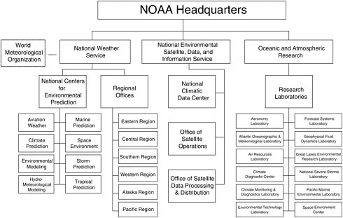
variety of national needs (e.g., agriculture, military, transportation). Providing reliable weather and climate information to the public requires expensive observing systems, long-term monitoring, and the synthesis of current and retrospective data from around the world, all of which NOAA, as a government agency, is well placed to do. NOAA has the primary civilian responsibility for installing and maintaining weather observing systems, negotiating data exchange agreements with other countries, and operating a climate data center that will hold the data in perpetuity. These functions are carried out by different parts of NOAA (Figure 2.1). State governments also collect data and operate data centers for the economic and public benefits they bring to the state.
Weather information disseminated to the public takes the form of forecasts, advisories, and other weather products. It is essential that the public be able to trust this government-generated information. Trust results from five primary characteristics of the information: (1) accuracy, (2) reliability,8 (3) objectivity, (4) open and unrestricted access, and (5) scientifically based error estimates. Making data easy and affordable to obtain also helps NOAA (and to some extent state agencies) fulfill its mandate of promoting scientific understanding of weather and climate phenomena, creating a more informed public, providing unbiased information (e.g., for legal or forensic purposes), and giving the commercial weather industry an opportunity to flourish.
The academic sector (i.e., universities and nonprofit research corporations such as the University Corporation for Atmospheric Research [UCAR])9 participates in the weather enterprise to fulfill its research and education mission. Scientists want to better understand the state of the
|
|
value of weather and climate services, not including the media and financial services, is estimated to be $500 million to $1 billion. See R. Pielke, Jr., and R.E. Carbone, 2002, Weather impacts, forecasts, and policy: An integrated perspective, Bulletin of the AmericanMeteorological Society, v. 83, p. 393-403; W.D. Nordhouse, 1986, The value of informa-tion, in Policy Aspects of Climate Forecasting, R. Krasnow, ed., Resources for the Future, Washington, D.C., pp. 129-134; R.M. Adams, K.J. Bryant, B.A. McCarl, D.M. Legler, J. O’Brien, A. Solow, and R. Weiher, 1995, Value of improved long-range weather informa-tion, Contemporary Economic Policy, v. 8, p. 10-19. If media and financial services are considered, the value of the market is considerably higher. For example, in 2000, weather derivatives contracts with a total value of $2.5 billion were issued in the United States (PricewaterhouseCoopers, 2001, The weather risk management industry: Survey findings for November 1997 to March 2001, A report to the Weather Risk Management Associa-tion, <http://www.wrma.org>). |
atmosphere and related systems such as the oceans and how they are changing. They also want to communicate this knowledge to their colleagues, students, funding agencies (primarily NOAA, the National Science Foundation [NSF], and the National Aeronautics and Space Administration [NASA]), the local community, and the general public. The resulting research results, models, technology, and information are generally placed in the public domain, either in scientific publications or on the web, or are transferred to the private sector. Some university researchers also consult for the weather industry for fees, and the resulting research is usually proprietary.
Finally, private companies—weather companies, university spinoffs, and the media—participate in the weather enterprise to sell weather products and services on an ongoing basis in a commercial market. Many industries (e.g., utilities, transportation, insurance, agriculture) also have meteorologists on staff to prepare weather products for internal purposes. Market incentives encourage private companies to generate innovative products or ways of presenting weather information. Private companies are usually highly specialized and provide products and services that are tuned to the needs of specific paying customers. Revenues are generated from a broad customer base (government, private, academic, general public), through either direct sales or advertising.
CURRENT ACTIVITIES OF THE SECTORS
Observations
A variety of federal, state, local, private, and international organizations collect and exchange meteorological data. An overview of the complexities of the U.S. observing system is given in Appendix C. NOAA collects data from satellites (e.g., images of clouds, global atmospheric temperature and water vapor profiles, and winds), reconnaissance aircraft (e.g., snow cover, profiles via dropsondes in tropical storms and hurricanes), upper-air balloons (vertical profiles of winds, temperature, and humidity), and land and marine surface sites (e.g., precipitation, streamflow, air and sea-surface temperature, humidity, winds, and other variables) (Table 2.1). Some of these stations are automated, such as those located at airports, and an additional 11,000 ground stations are staffed by volunteers through NOAA’s Cooperative Observer Network.10 NOAA also obtains
TABLE 2.1 Federal Facilities or Stations for Taking Meteorological Observations, FY 2001
|
Type of Observation |
NOAA |
Other Agency |
Total |
% NOAA |
|
Land surface |
841 |
2942 |
3783 |
22 |
|
Ships |
140 |
541 |
681 |
21 |
|
Buoys |
95 |
0 |
95 |
100 |
|
Other marine stations |
260 |
2 |
262 |
99 |
|
Atmospheric profilers |
0 |
7 |
7 |
0 |
|
Upper-air balloons |
108 |
237 |
345 |
31 |
|
Upper-air rockets |
0 |
2 |
2 |
0 |
|
Radars |
181 |
140 |
321 |
56 |
|
Aircraft |
3 |
10 |
13 |
23 |
|
Satellites |
4 |
5 |
9 |
44 |
|
SOURCE: Office of the Federal Coordinator for Meteorological Services and Supporting Research, The Federal Plan for Meteorological Services and Supporting Research, Fiscal Year 2002, <http://www.ofcm.gov/fp-fy02/fedplan.htm>. |
||||
real-time access to weather data from 184 countries through the World Weather Watch, including data from 9 satellites, 10,000 land stations, 7,000 ship stations, and 300 moored and drifting buoys.11
The core observations collected under the auspices of NOAA are supplemented by data collected by other federal agencies, state agencies, private companies, and academia. For example, DOD collects weather data to support military operations, and DOT collects data to improve the safety and efficiency of air, railroad, coastal waterway, and highway transportation systems.12 At the state level, all but four states deploy roadway weather information sensors, and several operate networks of soil moisture instruments. Some even own automated weather observing systems.13 Both state and private sector organizations collect local and regional air quality measurements. For-profit companies also measure basic meteorological parameters from ground stations (about 10,000 sensors)14 and from sensors
|
11 |
The World Weather Watch is the backbone of the World Meteorological Organization’s activities. See <http://www.wmo.ch/index-en.html>. |
|
12 |
Office of the Federal Coordinator for Meteorological Services and Supporting Research, The Federal Plan for Meteorological Services and Supporting Research, Fiscal Year 2002, <http://www.ofcm.gov/fp-fy02/fedplan.htm>. |
|
13 |
For example, see the Iowa Mesonet at <http://mesonet.agron.iastate.edu/pipermail/dailyb/2002-June/000125.html>, Michigan airport sites at <http://www.michigan.gov/aero/0,1607,7-145-6775_7025—,00.html>, and Florida Automated Weather Network at <http://fawn.ifas.ufl.edu/>. |
|
14 |
One of the largest networks is operated by AWS Convergence Technologies, Inc., which collects temperature, humidity, wind, pressure, and precipitation data at 5,000 sites. See <http://www.aws.com>. |
mounted on commercial aircraft (Appendix C). In addition, many television stations own a Doppler radar and operate networks of meteorological sensors, and many have dozens of observers in the field. Finally, some universities make local measurements or maintain networks for research purposes, such as SuomiNet.15 A few universities partner with government agencies and private companies to create state and regional networks, such as the Oklahoma Mesonet and MesoWest.16
Some of the data collected by private sector companies are used by the NWS for creating forecasts and warnings, particularly if the data are unique. For example, commercial airlines collect temperature, humidity, and wind data and provide them in real time to the National Centers for Environmental Prediction (NCEP), where they have proven very valuable to numerical forecasts. They also make them available for non-real-time government and academic research purposes (Appendix C). Another example is the lightning data that the NWS purchases from Vaisala-Global Atmospherics, Inc., which owns the nation’s only lightning network.17 However, the cost, difficulty of keeping track of and enforcing restrictions, and uncertainties about the quality of proprietary data mean that most private sector data are not used for public purposes (see Chapter 4).
Modeling
The federal government—mostly the eight NWS National Centers for Environmental Prediction but also DOD (the Navy and Air Force)—runs operational global and regional models. NCEP develops models for weather prediction (1-15 days), ocean prediction (daily to annual), and climate prediction (monthly, seasonal to interannual). These models are used by government agencies, academia, and the private sector. Other countries also produce numerical weather and climate models, such as the models of the European Centre for Medium-Range Weather Forecasts (ECMWF), but some of their model output is restricted, hindering their use by all sectors, particularly the private sector.18
|
15 |
SuomiNet is a university-based network of Global Positioning System receivers that produce vertical profiles of water vapor. A description is given in R.H. Ware, D.W. Fulker, S.A. Stein, D.N. Anderson, S.K. Avery, R.D. Clark, K.K. Droegemeier, J.P. Kuettner, J.B. Minster, and S. Sorooshian, 2000, SuomiNet: A real-time national GPS network for atmospheric research and education, Bulletin of the American Meteorological Society, v. 81, p. 677-694. |
|
16 |
<http://okmesonet.ocs.ou.edu/>, <http://www.jmet.utah.edu/jhorel/html/mesonet/info.html>. |
|
17 |
See <http://www.lightningstorm.com/ls2/discover/nldn/index.jsp>. Global Atmospherics, Inc., originated as a commercial spinoff from the University of Arizona. |
|
18 |
National Research Council, 1998, Capacity of U.S. Climate Modeling to Support Climate Change Assessment Activities, National Academy Press, Washington, D.C., 65 pp. |
Numerical models are used for both weather and climate forecasting. Weather forecast models are deterministic and must start out with initial conditions based on observations that are as accurate as possible. The accuracy and skill of the deterministic forecasts diminish with time until the limit to deterministic atmospheric predictability is reached, which is approximately two weeks. In contrast to weather forecast models, climate models are run for months to many years into the future. They generally contain models of the components of the climate system—the atmosphere, ocean, land, and ice—and these components interact in the coupled climate model. Details of the initial conditions of the climate models are of less importance than those of the weather prediction models, although climate models run out for a few months to a couple of years require good estimates of the ocean structure, especially near the surface. Climate models are used in many ways—to understand present and past climates, to project the climate many years into the future under various scenarios of climate forcing (such as changing greenhouse gas emissions or land use patterns), and to predict short-term climate change associated with seasonal and interannual variability (e.g., El Niño events).19
Academic scientists create atmospheric models capable of simulating weather and climate phenomena primarily for research and education purposes. Examples include the highly detailed models of convective cloud clusters produced by Colorado State University or models of squall lines produced by Oklahoma University. Some models are also run in an operational mode in which the resulting predictions are provided to the public, usually via the World Wide Web. The fifth-generation Penn State-National Center for Atmospheric Research (NCAR) Mesoscale Model (MM5)20 is often used this way (see the Antarctica rescue example in Chapter 3). Other models are intended to supply predictions for local use by state governments and private companies.21 Unlike NCEP models, however, these academic models do not have to be run every day on schedule, nor do they have to deliver specified products. Academic models are used by all the sectors. For example, in 2000, MM5 was used by 44 universities, 28 federal and state agencies, 60 foreign organizations, and 28 private companies.22
To better serve specific needs, the private sector usually modifies models developed by academia or the NWS, using initial conditions obtained from NCEP global models. For example, WSI runs a version of MM5 and the NWS seasonal model, which are in the public domain. The models are often run in operational or on-demand mode, depending on customer needs. Mesoscale models are useful complements to the global models run by NCEP and other international weather centers because they are scalable, will run on personal computers, produce very local predictions, and meet market demand for frequent forecast periods and updates. However, national and regional-scale models are also used. For example, Weather Central, Inc., runs Adonis, a variation of a University of Wisconsin model, at high resolution on a national scale. The predictions from these tailored models, as well as from NWS models, are used by hundreds of television stations to prepare their forecasts and graphics.
Forecasts and Other Weather and Climate Services
Weather Services
All three sectors produce forecasts and provide weather services. The major services provided by the NWS include weather advisories, watches, warnings, and forecasts; river forecasts; aviation weather services; marine weather services; fire weather services; tsunami warnings; and community preparation for weather-related disasters or storms. Forecasts and warnings are prepared by and disseminated through a national network of 122 weather forecast offices and 13 river forecast centers. The weather forecast offices are experts in their local areas and are responsible for watches, warnings, advisories, forecasts, and community interactions for an assigned geographic area. NCEP provides guidance on specific weather phenomena, from short-range forecasts to seasonal and interannual climate outlooks; the models used to prepare the forecasts; and forecasts and warnings from its specialized centers (e.g., tropical storms, aviation and marine weather). Other NWS offices deal primarily with topic-specific issues, such as aviation services. In addition to their primary research activities, some of the NOAA research laboratories develop numerical models, improve forecast methods, and produce other weather and climate services. They also provide training on the use of weather software and technologies developed at the laboratories to other government agencies (in the United States and abroad)23 and the private sector. Systems and software are placed in the
|
23 |
For example, the Forecast Systems Laboratory provides consulting on the development of wind profilers to DOD, NASA, and the Department of Energy, as well as the governments of Canada, Australia, New Zealand, China, Japan, and the European Union. See <http://www.fsl.noaa.gov/~vondaust/fir99/fir99c.html>. |
public domain, but ongoing technical support and weather and climate services to users are subject to full cost recovery.24
The academic sector creates weather products for research and educational purposes. A number of meteorology departments operate a campus weather service to train students to create and disseminate local forecasts. Some of the products are quite practical in nature, such as forecasts produced by Penn State University for the New York Times weather page.25 Penn State faculty members believe that this activity helps educates the students in the department. At the universities that the committee visited, professors drew a distinction between developing a unique product to advance the science and educate students and the general public, and providing commercial products, which they did not see as a university role. However, these products may also have value in the marketplace.
The private sector is a major generator of forecasts and weather products and services. These products and services are generally aimed at specific users who want products tailored to their application, local area, or economic need, compared to the more general weather products created by the NWS. Some companies use publicly available government information and add value by packaging the information in a form that is easier to understand or more convenient to use. For example, television stations use colorful graphics to make weather patterns predicted by the NWS more understandable to the public. However, an increasing number of products are a sophisticated synthesis of data, analyses, and model output gathered from government, academic, and private sources. Examples include weather forecasts with wind and temperature information to help trucking companies improve fleet fuel efficiency or wave and sea forecasts aimed at helping shipping companies reduce shipping time and costs.
Climate Services
NOAA, state government agencies, and academia provide longer-term climate data and services, including historical climate and paleoclimate records, seasonal to interannual predictions, and decadal to centennial as-
sessments. Within NOAA the National Climatic Data Center (NCDC), in partnership with the NWS, provides a wide range of climate data, information, and products that are used for planning purposes, such as designing buildings as well as power and water systems and for hedging against extreme weather and climate events.26 For example, regional climate data were recently used to support decisions on dam operations in the Grand Canyon.27 The regional climate centers provide climate information in their multistate area, develop climate products, conduct applied climate research, and monitor and assess the impact of climate conditions (e.g., drought, soil moisture) on the region.28 State climatologists perform a similar function in their state and also provide an important link to local users, including state and local officials and the media.
The NWS has the primary responsibility for developing operational seasonal to interannual predictions, such as those related to improving El Niño-Southern Oscillation (ENSO) forecasts.29 However, as understanding of the atmosphere and forecasting skills improve, private sector interest in providing these predictions will likely increase. Work on decades and longer timescales (e.g., to distinguish between anthropogenic forcing and natural climate variability) is still mainly in the research stage and is handled by NOAA laboratories—particularly the Climate Diagnostics Center and the Climate Monitoring and Diagnostics Laboratory—and academia.
Standards
In addition to carrying out the tasks outlined above, NOAA sets and maintains the observational and historic standards and records for operational meteorology and climatology in the United States. As the weather, oceanographic, and climatic “source of record,” NOAA is responsible for the collection of regular observations of the Earth’s atmosphere and oceans,
|
26 |
NOAA, 2001, NOAA’s Climate Observations and Services, Washington, D.C., 26 pp. |
|
27 |
R.S. Pulwarty and T.S. Melis, 2001, Climate extremes and adaptive management on the Colorado River: Lessons from the 1997-1998 ENSO event, Journal of Environmental Management, v. 63, p. 307-324. |
|
28 |
Information on the products and services of the regional climate centers can be found through links at <http://met-www.cit.cornell.edu/other_rec.html>. |
|
29 |
Seasonal to interannual forecasting grew out of the Tropical Oceans and Global Atmosphere Program (TOGA). Academic researchers developed many of the models, and forecasts and other products are produced by NOAA’s Climate Prediction Center (among other organizations). An assessment of short-term climate prediction can be found in National Research Council, 1996, Learning to Predict Climate Variations Associated with El Niño and the Southern Oscillation: Accomplishments and Legacies of the TOGA Program, National Academy Press, Washington, D.C., 171 pp. |
assembly of derived data from meteorological and climatic models, and calculation of climate averages. This task is difficult because data of different types and scales, often with incompatible formats and/or insufficient documentation, must be integrated and analyzed to be made useful to current and future generations of scientists. Failure to do so greatly diminishes the potential value of the climate record.30
NOAA is also responsible for verifying that its data and derived products (including forecasts) are rigorously checked for scientific validity. The meteorological and other user communities must be assured that advisories, warnings, and statements are prepared and verified in a scientifically objective manner. Finally, because weather and climate are global phenomena, the NWS must help set and adhere to international standards for data collection and exchange.
Archive
The primary archive for official weather and climate data is NOAA’s National Climatic Data Center. NCDC holds more than 1.4 petabytes of data from state institutions (state climatologist program and regional climate centers), federal agencies (e.g., Departments of Agriculture, Commerce, Defense, Energy, and Transportation; NASA, NSF), and international organizations (e.g., World Meteorological Organization, world data centers).31 However, 99% of the holdings are derived from NOAA-sponsored and -operated observing systems. The data and products, some of which extend back 200 years, are available at a nominal cost of retrieval and delivery to the customer and are used for operational, research, education, decision-making, business (e.g., consulting meteorology, legal, insurance, engineering, tourism), and individual purposes.
State climatologists and regional climate centers archive and disseminate data collected by state agencies and programs as well as data from NWS and cooperative observer stations in their state. Most of these data are available without restrictions, but the data are not always easily accessible and users often pay a small fee to obtain them.
Researchers also use the data collections hosted by NCAR. The data come from a variety of sources, including NCAR, university, NOAA, and ECMWF models and historical and global observations collected by other organizations. Private companies store data they collected, but operating a
long-term archive is not lucrative and some companies hope to eventually transfer their data to NCDC. Data held by private companies are available under whatever terms the company sets and cannot be considered part of the long-term climate archive.
USERS OF WEATHER AND CLIMATE INFORMATION
A strong positive feedback exists between increasing demand for weather and climate information and increasing accuracy of the information. As accuracy increases and as society’s sensitivity to weather and climate increases, the number of applications, the degree of specialization of products, and the number of customers who can use the information will also increase. Continuing advances in forecast accuracy not only will enable greater protection of life and property, but will also improve environmental management and create new business opportunities.32 One of these opportunities is helping users learn about useful weather and climate products and integrating imperfect forecast information into decision making.33
A wide variety of individuals and industries use weather and climate information to carry out their daily activities and to manage weather-related risk. The major users and uses of weather and climate information have been discussed in a recent National Research Council report Making Climate Forecasts Matter34 and are summarized below.
Agriculture
The agriculture industry depends on weather and climate information for coping with weather and climate risk. Examples of ex ante (based on expectations) decisions that are influenced by weather information include choices of crop mix, cultivar traits, amount of land to cultivate, frost protection, herd size, and placement of animals on rangeland and pastures.35
Longer timescale climate forecasts may be used to develop hedging strategies, such as purchasing crop insurance or using commodities futures markets to lock in a desired price before producing a crop. Ex post (based on event realization) decisions that are influenced by weather and climate information include the timing and amount of irrigation, application of pesticide and fertilizer, rate of animal feed, marketing of animals, drying of grain, and in the extreme whether or not to continue to grow and harvest a weather-damaged crop. The conditions predicted in the forecast (hot, cold, wet, dry) are of primary importance for these purposes,36 although inaccuracies in seasonal predictions require that they be taken with a grain of salt.
The Internet has been one of the biggest influences on the use of weather and climate information in agriculture.37 In 2001, 43% of farms had access to the Internet and 55% had access to a computer. Farmers can now obtain general weather forecasts for any part of the country, near-real-time radar data every six minutes, accumulated precipitation data, drought indices,38 and specialized forecasts and services. However, although the variety and accessibility of information products have never been greater, data coverage is still a limitation, especially west of the Mississippi where there are few cooperative observer stations. Linking mesonets and micronets would help fill in the data gaps and form a more effective observing network for agriculture applications.39
Forestry
Weather and climate information is relevant to many forestry practices, especially fire and pest management.40 Wet winter-spring conditions stimulate vegetation growth that, when followed by dry summer conditions, leaves a large fuel load and increases fire risk. Long-term forecasts and other weather and climate products are used to make decisions on when and where to restrict burning. Drought indices are used to monitor moisture stress on commercial forests.
|
36 |
Presentation to the committee by S. Hillberg, director, Midwestern Regional Climate Center, June 27, 2002. |
|
37 |
Presentation to the committee by S. Hillberg, director, Midwestern Regional Climate Center, June 27, 2002. |
|
38 |
Important tools include the weekly U.S. Drought Monitor and the U.S. Seasonal Drought Outlook, both of which are prepared under a multiagency partnership. See <http://www.cpc.ncep.noaa.gov/products/expert_assessment/drought_assessment.html>. |
|
39 |
The NWS is compiling a database of non-NOAA mesonets for improving data coverage. Integrating these networks into the national observing system will require harmonization of standards, formats, and data policy. |
|
40 |
National Research Council, 1999, Making Climate Forecasts Matter, P.C. Stern and W.E. Easterling, eds., National Academy Press, Washington, D.C., 175 pp. |
Pests and pathogen outbreaks are often induced and regulated by weather conditions. Weather information is used to help decide what pesticides to use and when and how they should be applied.
Water Supply and Flood Management
Weather and climate information is key to managing water supply systems at the individual, local municipal, and interregional levels.41 Historical climate information is critical to planning the size and operation of reservoirs. Except in cases of flooding, water supply systems tend to respond slowly and cumulatively to weather and climate variability. Strategic reservoir water releases are governed in part by seasonal streamflow forecasts and by observed seasonal snowpack amounts. Surface irrigation water allocations are influenced by information about cumulative soil moisture conditions over the growing season.
Flood events occur on shorter timescales (days or even hours) than the weather and climate conditions that regulate normal water supply operations. Real-time weather information and forecasts are crucial for posting short-term warnings and deploying protective measures such as sandbagging, pumping, and evacuation.
Transportation
Both surface and air transportation systems rely heavily on weather information. The Federal Highway Administration promotes the deployment of integrated road weather systems. Motor carriers use forecasts of road conditions for routing and scheduling. Weather information used includes road condition and temperature maps, severe storm warnings, and satellite and radar imagery.42 The marine cargo and passenger industries rely on integrated weather and navigation information systems, which provide high-resolution weather information and tools to compute alternative routes and fleet positions to accommodate different weather conditions.
The aviation industry uses a wide array of weather products, including radar imagery, current weather conditions, severe weather maps and warnings, hurricane tracking maps, winds and temperature aloft, and satellite imagery. These products are used extensively by airline operations control centers and flight crews.43 Dispatchers need weather data for pre-flight
planning and in-flight monitoring; airline meteorologists need forecasts for major hubs and gateway cities; and pilots need data for tactical purposes. Each carrier must use weather data from an approved source, usually a government agency (mainly the NWS), but if that is not available, from a private observer or automated weather observing system. The Internet is an approved distribution channel of data, but the Federal Aviation Administration cautions users that weather information obtained from qualified Internet communications providers may not be accurate, timely, or useful.44 Improvements that the industry would like to see include (1) Internet-based graphical products that portray current and forecast hazards to flight crews, (2) terminal-specific forecasts, (3) digital data that can be integrated into flight planning systems, and (4) more real-time data.
Energy
Producers and distributors of natural gas and electricity use weather and climate information to predict and monitor changes in demand and thereby improve planning in power production.45 Cumulative indices of heat and cold, such as heating and cooling degree-days, are widely used to monitor demand across all classes of consumers (industrial, residential, commercial). Improvements in seasonal to interannual forecasts will improve predictions of energy demand on longer and longer timescales.
Petroleum producers use information on tropical weather systems, high winds and wave heights, and abnormal currents to manage offshore drilling operations and to plan the transportation of supplies and personnel.46 Suppliers of hydroelectric power use streamflow forecasts and electric power distributors use weather forecasts to assist in dispatching crews to deal with the effects of severe weather on power lines or to take proactive measures to
|
43 |
Presentation to the committee from R. Gold, director, Airline Operations Control/Meteorology, Air Transport Association, November 5, 2001. |
|
44 |
Federal Aviation Administration, Criteria for Internet communications of aviation weather, Advisory Circular, November 1, 2002, <http://www1.faa.gov/ATS/ARS/QIPC/AC.DOC>. |
|
45 |
National Research Council, 1999, Making Climate Forecasts Matter, P.C. Stern and W.E. Easterling, eds., National Academy Press, Washington, D.C., 175 pp. |
|
46 |
M.G. Altalo, 2000, Defining the requirements of the U.S. energy industry for climate, weather, and ocean information, Report to NOAA’s Office of Oceanic and Atmosphere Research, 146 pp. |
minimize outage time.47 Local natural gas distribution companies in some states use weather information to normalize their revenues in preparing applications to regulatory agencies for price changes.
Public Health
Extreme and prolonged cold and heat cause hypothermia and heat stress, and less directly, weather conditions influence disease ecologies that can result in major outbreaks of infectious diseases such as influenza, hantavirus pulmonary syndrome, and malaria. Weather information is routinely used to convey alerts for heat waves and extreme cold. Climate-based forecasts of disease outbreaks, such as influenza, are used to develop and disseminate vaccination programs. It may soon be possible to forecast pollution levels that trigger asthma or other respiratory problems.48 Public health officials would benefit greatly from improved tools and procedures for incorporating weather information into risk management. Timely climate predictions, coupled with sophisticated models developed in collaboration with epidemiologists and entomologists, will offer new tools for combating disease.49
Disaster Insurance and Reinsurance
Insurers provide financial compensation to subscribers who experience loss from extreme weather events such as tornadoes, hurricanes, hail, and floods.50 They also reduce the vulnerability of subscribers by offering incentives such as lower premiums to those who take preventive actions (e.g., making structural improvements to insured buildings, constructing on lower-risk property). Some insurers spread their own risk even further by purchasing reinsurance from private companies or the government. Reinsurance helps insurers cope with catastrophic loss such as the esti-
mated $16 billion in insured losses from Hurricane Andrew in 1992.51 Reinsurance spreads risk across a larger clientele (in some cases, all taxpayers) than are served by individual insurance companies.
Insurers and reinsurers use weather and climate information to calculate actuarial risk. Many insurance companies employ atmospheric scientists or contract with private weather service firms to aid in such calculations. A special type of insurance is provided by the weather derivatives industry, which uses weather information to defray risk associated with normal weather variability.52 The weather derivatives industry depends on reliable, quality-controlled weather information from objective sources. In particular, the industry needs indices—heating and cooling degree-days, total precipitation, annual streamflow, and accumulated snowfall—tailored to the needs of specific clients (e.g., ski slope operators, natural gas distribution companies, outdoor apparel manufacturers). Further improvements in the analysis of weather derivatives will depend on improvements in seasonal prediction models (especially land-atmosphere interactions), dense geographic coverage of measurements, and homogeneous climate time series on daily and hourly timescales.53
Emergency Preparedness and Response
Responsibility for emergency preparedness and response falls mainly on governments at all levels (local, state, federal) and on nongovernmental organizations (e.g., the Red Cross). Emergency managers are concerned almost exclusively with extreme weather—drought, wildfires, floods, severe weather, and tropical cyclones—or temperatures.54 Weather and climate information is used ex ante for issuing warnings and evacuations and positioning staff and supplies, and it is used ex post to manage rescues and
coordinate cleanup operations.55 Weather products that are useful to emergency managers include hazards assessments and maps, drought indices, and precipitation and severe weather forecasts, all of which are created by the NWS or the academic community and are available through the Internet. To get the most out of existing weather products, emergency managers need information in formats suitable to nonscientists and training to apply weather information to actions.
Because of the costly and disruptive nature of evacuations, it is important to have accurate forecasts of hurricane track and intensity, for example, to reduce overwarning.56 Long-term warnings (one- to three-day forecasts) have improved greatly over the last five years and are now being used for decision making.57 Further improvements should be aimed at providing longer lead times (some areas must be evacuated before a watch or warning is issued), better quantification of forecast uncertainties in hurricane and flood warnings, and tools for integrating probabilistic forecasts with other data sets.58
Other Users
Many other industries, groups, and individuals use, or could use, weather and climate information. For example, the construction industry uses weather information to schedule specific activities and to purchase materials. Fisheries managers use weather information to manage fleet operations and monitor fish stocks. The recreation industry uses weather information in a variety of ways ranging from issuing avalanche warnings, backcountry conditions, and boating conditions to managing snowmaking operations for skiing. The legal industry uses certified weather and climate information in court cases. The list of potential uses is long and growing longer as the accuracy and reliability of weather and climate forecasting improve and the portfolio of weather services offered to the public grows.
SUMMARY
The public, private, and academic sectors collect data, run models, generate forecasts, and disseminate weather products to support their respective missions. NOAA operates the national observing system and is responsible for the U.S. contribution to the global observing system. State and local governments, academia, and the private sector supplement the national network with denser arrays of instruments. Integrating these local data into national databases will help fill data gaps, once the issues of standards, formats, data quality, and data policy have been resolved. Models are developed primarily by the NWS and academia, although the private sector is becoming more sophisticated in customizing existing models and developing its own. Weather and climate products produced by the NWS tend to be general, except for products aimed at industries specified in the NWS mission, such as aviation and emergency management. NWS and state agency products are also used preferentially by user groups that require official and/or unbiased information, such as the weather derivatives and legal industries. Other industries and user groups employ a combination of government, academic, and commercial products. Weather products created by the private sector (including meteorologists working in industries affected by weather) tend to be much more specialized than NWS products to meet the needs of particular user groups. Climate products fall mainly in the domain of NOAA, state climatologists, and regional climate centers, but the private sector will be an increasing player as the accuracy of seasonal to interannual forecasts improves and climate products become more useful to industries such as insurance, energy, health, and agriculture.


