1
Introduction
The Earth’s atmosphere, oceans, landsurface, interior, and near-Earth space form an integrated system in which changes in one element of the system may affect the others. Understanding the elements of this system, the way they interact, and how they have changed through time requires the collection and synthesis of a wide variety of scientific data acquired, often continuously, over long periods of time from a wide range of scientific instruments located in different geographic regions and different regions of the near-Earth space environment. These data provide the basis for understanding the causal relationships between physical processes that occur within this complex system. An example is the determination that major geomagnetic storms are initiated by sporadic ejections from the outmost layer of the solar atmosphere propagating through space and affecting the Earth’s magnetosphere.1 Over longer periods of time geophysical data are necessary for detecting and monitoring environmental trends. For example, changes in the Earth’s magnetic field over decades to centuries contain a wealth of information on the dynamics of the Earth’s deep interior; changes in the composition of seafloor sediments over hundreds of thousands to millions of years are used to reconstruct past climates and to help elucidate the cause and variability of global
|
1 |
Office of the Federal Coordinator for Meteorology, 1995, National Space Weather Program: Strategic Plan, FCM-P30-1995, Washington, D.C., <http://www.ofcm.gov/nswp-sp/text/a-cover.htm>. |
climate change; and long-term changes in the level of geomagnetic activity are used to infer changes in the Sun’s magnetic field and the solar wind, possibly of significance to global change.2 Long-term, continuous data records are also useful for practical applications, such as planning for geomagnetic-storm-induced power and communications disruptions3 or for establishing reliable baselines for geomagnetic surveys. Much of the data used in the above applications are archived at the National Oceanic and Atmospheric Administration’s (NOAA’s) National Geophysical Data Center (NGDC).
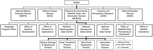
Although a number of federal and state government agencies collect environmental data, NOAA is responsible for providing long-term stewardship of environmental data, thereby ensuring their usefulness to current and future generations of scientists.4 This mission is carried out under the auspices of NOAA’s National Environmental Satellite, Data, and Information Service (NESDIS), which operates three environmental data centers: NGDC, the National Climatic Data Center (NCDC), and the National Oceanographic Data Center (NODC). Together, the data centers disseminate and archive over 1 petabyte (1015 bytes) of data that are used to study processes operating anywhere from the center of the Earth to the Sun. NGDC has the smallest base budget of the NOAA data centers (Table 1.1), but its holdings span the most disciplines. NGDC’s holdings include information on aurora, cosmic ray, ionospheric, and solar phenomena; bathymetry, topography, and relief; earthquake, volcano, and tsunami hazards; ecosystems; geomagnetism; marine geology; marine trackline geophys-
|
2 |
J.D. Hays, J. Imbrie, and N.J. Shackleton, 1976, Variations in the Earth’s orbit: Pace-maker of the ice ages, Science, 194, 1121-1131; N.J. Shackleton, S.J. Crowhurst, G.P. Weedon, and L.J. Laskar, 1999, Astronomical calibration of Oligocene-Miocene time, Philosophical Transactions of the Royal Society of London, Series A, 357, 1907-1930; C.T. Russell, 1975, On the possibility of deducing interplanetary and solar parameters from geomagnetic records, Solar Physics, 42, 259-269; M. Lockwood, 2001, Long-term variations in the magnetic field of the sun and heliosphere: Their origin, effects and implications, Journal of Geophysical Research, 106, 16,021-16,038. |
|
3 |
Use of good geomagnetic storm forecasts could save the U.S. electricity industry $350 million over three years. See NOAA economic statistics, May 2002, <http://www.publicaffairs.noaa.gov/worldsummit/pdfs/economicstats.pdf> and references therein. |
|
4 |
At the federal level environmental data are collected by the 10 agencies that participate in the U.S. Global Change Research Program: Departments of Agriculture, Defense, Energy (DOE), and Health and Human Services; Environmental Protection Agency; National Aeronautics and Space Administration; NOAA; National Science Foundation; Smithsonian Institution; and the U.S. Geological Survey (USGS). See Climate Change Science Program and the Subcommittee on Global Change Research, 2002, Our Changing Planet: The Fiscal Year 2003 U.S. Global Change Research Program and Climate Change Research Initiative, Washington, D.C., 124 pp. DOE and USGS also have a formal mission to archive environmental data. However, the vast majority of environmental data collected by federal agencies is eventually archived at NOAA. |
TABLE 1.1 Vital Statistics of the NOAA Data Centers
|
FY 2002 Budget |
||||||
|
Data Current |
Number of Staffa |
Base ($M) |
Total ($M) |
Base/Total (%) |
Base/Staff ($k) |
Center Holdings (TB)b |
|
NCDC |
173 |
12.0 |
44.4 |
27 |
69 |
704.7 |
|
NODCc |
56 |
5.3 |
7.9 |
67 |
95 |
1.5 |
|
NGDC |
51 |
4.3 |
9.0 |
48 |
84 |
37.6 |
|
a Full-time equivalents, including only federal workers. NGDC figures include two vacancies. b TB = terabyte. Single copy of data; all the data centers also hold backup copies, which doubles the data volumes shown, to comply with National Archives and Records Administration standards. c Figures exclude the National Coastal Data Development Center and the NOAA library, which are funded through NODC. |
||||||
ics; land geochemistry, geothermal, and gravity data; and marine well log data (Appendix C). The collocation of this wide array of data and information products provides a number of scientific advantages, such as enhancing opportunities for cross-disciplinary research. However, it also poses management challenges, such as maintaining sufficient expertise in the data to serve users or defining the center’s focus to NOAA and the broader community. This report reviews NGDC’s practices in collecting, disseminating, and archiving marine, solar-terrestrial, and geophysical data and assesses how well the center is managing its holdings, serving its users, and supporting NOAA’s mission. The formal charge to the committee is given in Box 1.1.
|
BOX 1.1 Committee Charge At the request of Gregory Withee, assistant administrator for satellite and information services, the National Research Council Committee to Review NOAA’s National Geophysical Data Center was established to review NGDC, with particular emphasis on answering the following questions:
|
HISTORY OF NGDC
NGDC was created in 1965 from existing data programs in the Department of Commerce, particularly the Coast and Geodetic Survey and the Central Radio Propagation Laboratory. Initial holdings included gravity, seismic, tsunami, geodetic, and geomagnetic data. NGDC also operated world data centers (WDCs) for gravity, seismology, and geomagnetism, which archived and disseminated data related to the International Geophysical Year.5 In 1972 NGDC merged with the Solar-Terrestrial Data Center, and marine geology and geophysics data were transferred from NODC to NGDC over the next few years. By 1975 the three main foci for the center emerged: solid earth geophysics, solar-terrestrial physics, and marine geology and geophysics.6 World data center activities were organized under the solid earth geophysics and solar-terrestrial physics divisions at that time, and the WDC for Marine Geology and Geophysics was established in 1982.7 The National Snow and Ice Data Center was also created in 1982 and took over responsibility for the World Data Center for Glaciology. Since then, the holdings of NGDC have grown and diversified, but the only major change in focus came in 1990, when the NOAA paleoclimatology program was created at NGDC. However, responsibility for paleoclimate data was transferred to NCDC in 2002 to “improve the performance of our climate work within NESDIS.”8 Other holdings that have been transferred from NGDC to other agencies in recent years include seismic data (earthquake, strong motion, multichannel) and operational
|
5 |
The International Geophysical Year of 1957-1958 was intended to allow scientists from around the world to take part in a series of coordinated observations of various geophysical phenomena. These observations were archived and disseminated through world data centers operated under the auspices of the International Council for Scientific Unions and hosted by the United States, Soviet Union, Europe, Asia, and Australia. Since that time, the World Data Center system has broadened into new disciplines and now comprises about 50 centers that collect, archive, and distribute a wide range of solar, geophysical, and environmental data for scientific purposes for no more than the cost of filling a user request. See S. Ruttenberg and H. Rishbeth, 1994, World Data Centers—past, present and future, Journal of Atmospheric and Terrestrial Physics, 56, 865-870; International Council for Scientific Unions, 1996, World Data Center System Guide, Boulder, Colo., 109 pp. |
|
6 |
The Marine Geology and Geophysics Division was a branch of the Solid Earth Geophysics Division until 1981. |
|
7 |
The list of world data centers, including the three operated by NGDC—World Data Center for Marine Geology and Geophysics, World Data Center for Solar Terrestrial Physics, and World Data Center for Solid Earth Geophysics—appears at <http://www.ngdc.noaa.gov/wdc/wdcmain.html>. |
|
8 |
Memorandum from Gregory Withee, assistant administrator, satellite and information services, to Michael Loughridge, director, NGDC, April 17, 2002. |
activities in geomagnetism, which were transferred to the USGS in 1973.9 The USGS now operates U.S. seismic and geomagnetic observing stations, although NGDC retains certain archive, dissemination, and international data responsibilities in these areas. Aeromagnetic data were returned to the USGS in 1999 when the agency obtained resources to reanalyze and disseminate them.10 Despite these changes NGDC remains organized along historical lines, with three scientific divisions—solid earth geophysics, marine geology and geophysics, and solar-terrestrial physics—and an information services division (Figure 1.1).
ORGANIZATION OF THE REPORT
This report considers the purpose, function, and operation of NGDC and the opportunities and challenges it has within NOAA to provide comprehensive access to and stewardship of a wide range of geophysical data. The review was conducted from the perspective of the scientific user community; biographical sketches of the committee members are given in Appendix A. Chapter 2 gives an overview of NGDC data center functions, from data acquisition to customer service to long-term archiving. These data center functions were evaluated using criteria listed in Appendix B. A list of NGDC holdings is given in Appendix C. The remaining chapters are organized to answer the questions posed to the committee. Chapter 3 focuses on ways to improve the effectiveness of NGDC in the areas of data collection, customer satisfaction, and data management. It also deals with management issues such as organization, resources, and performance measures. NGDC’s performance measures for fiscal year 2002 are given in Appendix E. Chapter 4 examines NGDC’s mission and vision and its role within NESDIS and NOAA. The missions, themes, and strategic objectives of NGDC, NESDIS, and NOAA are given in Appendix D. Chapter 5 contains the conclusions of the report. Finally, a list of acronyms is given in Appendix F.