
3
A Common Coastal Zone Reference Frame: The Seamless Coastal Map and Consistent Shoreline
Working in the coastal zone presents aspecial challenge, as coastal processes are dynamic and often continuous across the land-sea interface, whereas the maps and charts that are used have historically been collected in either one realm or the other. Differences among agency missions and onshore versus offshore topographic and bathymetric mapping techniques, different vertical reference frames used for each of these products, and the inherent difficulty of collecting source data in the surf and intertidal zones have combined to produce a fundamental incompatibility between onshore maps and offshore charts. Yet as seen in the preceding chapter, seamless geospatial datasets across the land-water interface are needed by almost all users wrestling with issues of navigation, resource management, planning, hazard delineation and mitigation, environmental studies, and regulation issues. Often under contractual pressure, the problem of creating a seamless product is frequently solved by ignoring—through data blending and large-scale spatial averaging—datum transformation issues and the unmapped intertidal region. In so doing, what had originally been carefully positioned geospatial data becomes geospatially error-ridden in the interest of product delivery. An additionally troublesome feature of this approach is that no true database is generated—the product is one of a kind and cannot serve as an accurate base for additional studies. Furthermore, the geospatially compromised product is often exported to downstream users without their awareness of the inherent geospatial errors and uncertainties.
These error-ridden products may go on to be applied in inappropriate ways. For instance, modeling studies of marine hazards such as tsunami
inundation, high-wave flooding, and storm surge flooding rely on integrated depth and elevation data. Such modeling exercises are often based on geospatial data that have positional uncertainties of tens of meters, in addition to the model prediction uncertainties of tens of meters. The final product, with its partially undetected errors as well as uncertainties of many tens of meters in horizontal space and several meters in vertical space, may be used by authorities for hazard management and mitigation (e.g., the identification of evacuation routes). There is enormous potential for catastrophe if vehicles are directed to use a flood-prone evacuation route that was selected because of faulty elevation data input to a storm surge model.
As discussed in Chapter 2, an additional critical information element for a wide variety of public and private entities is the shoreline position. Although depicted as a fixed line on maps and charts, shorelines are dynamic features that present unique challenges to coastal managers. The diminishing amount of land area available for development and the overwhelming importance of shorelines as economic, cultural, environmental, and recreational resources place a premium on understanding shoreline dynamics and mapping the characteristics of shoreline change.
Few state, local, or private organizations make their own maps and charts and thus must extract shoreline information from either U.S. Geological Survey (USGS) topographic maps or National Oceanic and Atmospheric Administration (NOAA) nautical charts. In a great many cases the jurisdictional needs of state and local agencies are not represented by the boundaries provided on these federal maps, and the maps themselves leave the zone between Mean Sea Level (MSL; as delineated by the USGS shoreline) and Mean High Water (MHW) or Mean Lower Low Water (MLLW; as delineated by the NOAA shoreline) unmapped because of the gap between USGS maps and NOAA charts. As a result, state and local needs are often left unfulfilled. Even worse, errors are frequently promulgated through imprecise attempts to rectify this situation. The problem of consistent shoreline definition applies equally to the Great Lakes coastline. In a funding environment where coastal zone management funds are allocated on the basis of shoreline length, equity among the states requires that a consistent set of definitions and procedures be applied.
The lack of accurate maps and charts that seamlessly cross the land-sea interface creates a serious obstacle for the coastal zone managers of our nation. These managers need precise, accurate, and timely data and products that are easily accessible and usable for a wide variety of applications. A remedy for this situation, and the committee’s vision for the future, is the development of a seamless transformation framework that is available through a single digital portal that offers data, maps and charts, and tools as well as the ability to translate rapidly from one jurisdictional
shoreline to another. Such a portal would be constantly updated with timely datasets and would offer transformations to all major international, federal, state, and local shoreline needs coupled with tailored map production. In the following sections the impediments to fulfilling this vision of a seamless coastal geospatial product and possible strategies to overcome these impediments are described in more detail.
THE NEED FOR A COMMON FRAMEWORK
The most critical technical barrier to completing the vision of a seamless coastal map is the lack of a common reference framework that would allow cartographers and coastal zone data managers to weave together topographic datasets (e.g., USGS Digital Elevation Models [DEMs]) and bathymetric datasets (e.g., NOAA’s hydrographic survey data) in a way that is faithful to cadastral, geodetic, and cartographic standards. This deficiency arises for a number of reasons primarily related to differences in the projections, scale, and horizontal and vertical datums. While problems with horizontal datums, scales, and projections can be resolved with well-documented digital data and existing tools, resolving vertical datum discrepancies is a much more difficult task.
All geospatial datasets must be referenced to some kind of a vertical datum. Unfortunately, there is no consistent level that is used for this reference. This is due to both historical technical limitations (inaccuracies in locating points in a pre-global positioning system [GPS] world) and also because of the different protocols and datums used to produce onshore maps and offshore charts. For instance, USGS DEMs are horizontally referenced to the North American Datum 1983 (NAD83) and vertically referenced to an orthometric datum that approximates MSL (defined by the North American Vertical Datum 1988—NAVD88). Older USGS map products used an earlier vertical reference—NAVD29. However, the shoreline depicted on USGS map products does not represent the position where these datums intersect the earth’s surface but instead is the opportunistic instantaneous waterline captured in aerial photographs used in making the map. NOAA nautical charts are also horizontally referenced to NAD83, but all soundings are referenced to contemporaneous local MLLW—the average of the lower low water height of each tidal day taken over the National Tidal Data Epoch. NOAA charts depict both MHW and MLLW as two shorelines located using tide-controlled aerial photography. Neither of these shorelines corresponds to the MSL shoreline of the land-based USGS topographic maps.
A map producer will encounter additional inconsistencies in datum delineation when integrating modern and historical data for the purpose of delineating environmental and cultural changes through time. For
instance, the USGS National Shoreline Assessment project (as well as several state-sponsored projects) attempts to incorporate historical NOAA topographic maps (“T-sheets”) with modern orthorectified aerial photographs, as well as topographic and bathymetric Light Detection and Ranging (LIDAR) data. Historical T-sheets from the pre-World War II era were referenced by surveyors of the time to the local high-water mark, as delimited by debris and other indicators along the shoreline. There are substantial uncertainties associated with how these historical local levels correlate to modern MHW, given the influence of subsequent sea-level changes, land-level changes, seasonal wave conditions, and thermal changes in water level since the time of these past surveys, together with changes in shoreline position due to sediment flux. It is widely misunderstood that the older historical T-sheets present MHW when in fact they simply present a high-water mark on the shoreline. Further, modern NOAA nautical charts present a line that is identified as the position of MHW. In reality the line is the drafted waterline from aerial photography flown at the approximate time of MHW (as predicted by a model). This line differs from the true position of MHW due to the influence of wind and wave set-up (or set-down), which is capable of changing sea-level position by a meter or more. Finally, the position of any given water level (e.g., MLLW) constantly moves along the shoreline in response to the migration of the tide wave as it responds to gravity and friction. A cartographer tasked with integrating bathymetric data with topographic data must know the instantaneous position of that wave (the water level) at closely spaced positions along the mapped area to properly correct geospatial data. This requires a numerical model that predicts the position of the tide level through the highly crenulated bays and promontories of the U.S. shoreline.
The problem of vertical datums is confounded by the fact that multiple agencies at many levels of government (federal, state, and local), researchers, and the private sector also use different horizontal datums, different scales, and different projections. If only paper products are produced, there is little opportunity to transform and thus seamlessly integrate these individual products. However, if data are digital and well documented, tools currently exist to correct and transform differences in resolution, horizontal datum, scale, and projection (e.g., Figure 3.1). Unfortunately, we do not yet have the infrastructure in place to ensure that data are collected in such a form. Thus, along with the difficulties in producing mapping products that are continuous across the shoreline, there are also inconsistencies in producing mapping products that are continuous along the shoreline, particularly where such products cross jurisdictional boundaries.
With these unresolved differences or discrepancies in vertical datums associated with onshore versus offshore data, it is not possible to generate
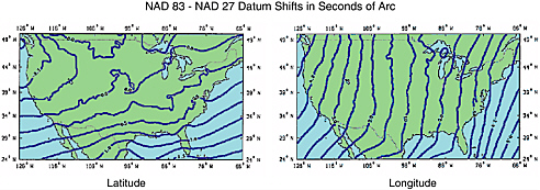
FIGURE 3.1 Maps showing datum shifts (in seconds of arc) between NAD 83 and NAD 27 datums, output from NADCON software, the federal standard for NAD 27 to NAD 83 datum transformation produced by NOAA-National Geodetic Survey (NGS). Similar tools are available for projection conversions, but the data must be digital and well documented. Image courtesy NOAA-NGS.
an accurate map that seamlessly crosses the land-water interface. Although very useful generalized products that ignore these discrepancies by averaging over large spatial area (e.g., the National Geophysical Data Center’s Coastal Relief Model with 90-meter spatial resolution) can be produced, these products will be of little or no use for detailed study of any process that needs to be accurately mapped across the land-water interface (e.g., mapping for flood hazard mitigation).
STRATEGIES FOR DEVELOPING A COMMON FRAMEWORK
The first step toward developing a truly useful coastal mapping product is to produce a seamless bathymetric/topographic model across the land-water interface. To accomplish this, it is necessary to reference all data (land-based elevations and offshore depths) to a common, continuous, and universal datum. Fortunately, modern GPS measurements provide the opportunity to use just such a common datum—the ellipsoid. GPS measurements are made using a three-dimensional coordinate system that is converted to an ellipsoidal coordinate system. The ellipsoid provides a geometric model that approximates the shape of the earth’s surface (without the topography). The GPS ellipsoidal coordinates combined with gravity (geoid) data provide elevations compatible with the orthometric heights (approximating MSL) used on USGS topographic maps. Therefore, both elevation and bathymetric data collected with GPS can be referenced to this continuous (albeit mathematically projected) ellipsoidal surface.
While elevations and depths can both be referenced to the ellipsoid datum, there will always be a need to present data with respect to the more traditional tidal or orthometric datums. Nautical charts, for example, must always be referenced to a tidal datum to ensure that a mariner will know the depth of water with respect to the real water level (and thus avoid running aground). To assist safe navigation, NOAA uses MLLW because it is a very conservative estimate of the water level. Topographic maps are typically referenced to an orthometric datum because it approximates MSL. The key to producing a seamless dataset across the coastal zone, however, is to understand the differences between the reference surfaces used to make the measurements (i.e., the differences between the ellipsoid and real terrain, between the ellipsoid and the geoid, between the ellipsoid and MLLW, etc.). These differences are expressed as “separation” or “difference” models, and with detailed knowledge of these models, conversions can be made among the various reference frames to produce a seamless dataset—a Coastal Terrain Model (CTM) across the coastal zone (see Figure 3.2).
Vertical information collected on land is measured from fixed platforms or from airborne or spaceborne platforms whose elevations can be very precisely determined in a fixed reference system. Bathymetric data, on the other hand, present a more difficult problem because they have historically been collected shipboard on a surface that constantly changes with the tide. True vertical reference frames for bathymetric data exist only at a few discrete points where water-level gauges have precisely defined a datum like MLLW (and thus where a difference or separation model exists). In order to extend (spatially integrate) the vertical reference frame established at the discrete points where MLLW has been accurately measured by tide gauges, sophisticated hydrodynamic models are needed.
Development of the CTM thus requires vertical datum integration, supported by appropriate tide gauge stations and meteorological observations, together with tools for hydrodynamic modeling. Since the depths are defined based on the MLLW level, long-term observations of water gauge stations are needed to determine the MLLW, and GPS surveys are then required to transform the MLLW to the orthometric datum. Consequently, the depth information can be referenced to the orthometric datum, and the topographic and bathymetric data can be integrated into one unique CTM. Once a continuous CTM is available, the hydrodynamic model can be used as a tool to produce water datum surfaces of MHW, MLLW, or any other mean water levels required by the various users. The intersection of the CTM and a water datum surface will generate a digital shoreline defined to that water datum. Thus, in order to generate a shoreline of a particular definition (e.g., MHW), the MHW surface needs to be output by the model and the MHW shoreline can then be produced as the
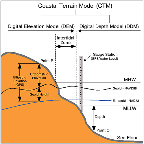
FIGURE 3.2 Coastal reference systems and observations, illustrating the components of onshore elevation (e.g., Point P) and offshore bathymetric (e.g., Point Q) data. Based on Li et al. (2003).
intersection line of the CTM and the MHW surface. Therefore, this approach provides a means to digitally produce any datum-defined shoreline and to transform between shorelines with differing definitions.
The development of a hydrodynamic tidal model also allows the transformation of historical datasets to a common ellipsoidal datum. NOAA, USGS, and other partners have undertaken a pilot project in Tampa Bay, Florida, that has demonstrated both the complexity and the feasibility of generating a seamless bathymetric/topographic dataset (see
Box 3.1). This project required the establishment of a fully calibrated hydrodynamic model for Tampa Bay and the development of a vertical datum transformation tool (Vdatum) that allows the easy transformation of elevations among as many as 26 orthometric, three-dimensional, or tidal datums. This pilot project has proven very successful and provides a clear indication of an optimum mechanism for producing seamless coastal charting products.
IMPLEMENTATION OF A COMMON NATIONAL FRAMEWORK
The Tampa Bay Bathy/Topo/Shoreline Demonstration Project demonstrated that, although complex, it is possible to establish a seamless coastal framework. The project has also demonstrated the value of interagency collaboration. The next step is to establish a national framework that provides a seamless bathymetric/topographic dataset for all U.S. coastal regions. Although horizontal datum issues can be readily resolved with existing transformation tools, vertical datum issues present the most serious challenge to this effort. To resolve the vertical datum issues, a project to apply Vdatum tools on a national scale is needed, involving the collection of real-time tide data and the development of more sophisticated hydrodynamic models for the entire U.S. coast, as well as the establishment of protocols and tools for merging bathymetric and topographic datasets. The resulting dataset must be documented and disseminated in such a way that it can become the basemap for a wide range of applications, including the definition of local, regional, or national shorelines.
Based on presentations and information provided by NOAA-NGS, a national Vdatum project would require an initial five-year effort to expand the current tidal modeling efforts to include all geographic areas of the U.S. coast. This would involve the development of numerical tidal models1 that in some areas would require the installation of additional tide gauges. Modeling results would be available to users on an area-specific basis through a Web-accessible database. This database could be linked to the single Web-based coastal geospatial data portal described below (see Chapter 5).
A national Vdatum Web site, linked to a national coastal zone mapping portal, would ensure that the full suite of Vdatum (and other) transformation tools would be easily available to the user community as well as ensure that data standards and acquisition details would be fully
|
BOX 3.1 In this joint demonstration project for the Tampa Bay region, NOAA’s National Ocean Service (NOS) and the USGS’s Geography Discipline (formerly the National Mapping Division) blended their bathymetric and topographic datasets into a DEM with all data initially referenced to the ellipsoid. A fully calibrated hydrodynamic model of Tampa Bay was used to determine the geographic distribution of tidal datums, and the Vdatum tool was used to transform all bathymetric data from the MLLW datum to the ellipsoid (Parker et al., 2001). Recent high-resolution third-party bathymetric and topographic data are being incorporated into the DEM. An up-to-date high-resolution shoreline is being developed using data from various airborne and satellite remote sensing sources. The DEM, shoreline, and additional data layers will ultimately be available from a Web-accessible database and on CD-ROM. The Web-accessible bathy/topo DEM and accompanying shorelines will not only solve the problem of inconsistency between NOAA and USGS products that has caused difficulty for coastal managers but will also provide a standard DEM (or framework) on to which others can append their bathymetric, topographic, or other data and will allow detailed modeling of storm-surge or sea-level rise effects. This is the first step toward the development of a mutually agreed upon “national shoreline.” It is also an excellent example of interagency collaboration and cooperation and a clear indicator of a viable approach to addressing the issue of a seamless vertical datum for the coastal zone. For NOAA and USGS it represents the beginning of a new way of doing business with each other that will reduce duplication of effort and better meet the needs of state and local agencies. |
described with metadata. Once established, the national framework would need to be maintained and regularly updated. Again, a Web portal is the key to the dissemination and timeliness of information. In addition to the modeling efforts associated with a national framework for seamless coastal data integration, there would be the need to collect additional coastal zone framework data (topography, bathymetry, and tidal information), particularly in the very shallow region at the land-water interface. Such an expanded mapping effort is discussed in Chapter 4.
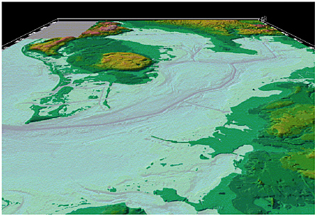 Three-dimensional model of seamless dataset produced by Tampa Bay Bathy/Topo/Shoreline Demonstration Project with high stand of sea level superimposed. Image courtesy of the Center for Coastal and Ocean Mapping, University of New Hampshire. |
WHERE AND WHAT IS THE SHORELINE—IS A NATIONAL SHORELINE NEEDED?
Inextricably linked to the establishment of a national framework for seamless coastal mapping products is the issue of a national shoreline. As the fundamental boundary for so many applications and studies, the lack of a consistently defined shoreline has frustrated coastal zone managers, planners, and scientists for many years. Since shoreline definitions typically relate to a water level, the shoreline is dynamic, changing over
various temporal and spatial scales. As noted earlier, the shoreline is not a deterministic physical line but rather a conceptual line defined on a statistical basis over a finite time. The long-term accuracy and consistency of shoreline maps cannot be assured, in part because they are subject to ceaseless natural and man-made processes that continually alter the shoreline’s shape and character. Modernization of the nation’s definition and depiction of the shoreline through development and application of state-of-the-art geospatial mapping techniques is urgently needed to address a wide variety of management, policy, and legal issues on local, national, and international scales.
Although a public law passed by Congress in 1998 provides explicit authority for NOAA to promulgate national standards for all information acquired for nautical charting purposes, including shoreline delineation, several different shoreline definitions are in use by various federal, state, and local authorities to meet non-navigational needs. A single nationally accepted and consistent U.S. shoreline does not exist, and the use of inconsistent shoreline definitions between maps, charts, GIS outputs, and other products leads to user confusion and ill-informed decision making. Another reason for this lack of consistency appears to be the significant overlap in federal efforts to acquire coastal shoreline data and in the subsequent generation of derived products, such as shoreline erosion and accretion maps. This issue is important enough that it will be discussed separately in Chapter 6.
As discussed in Chapter 2 and illustrated in Figure 2.1, the U.S. coastal zone encompasses a bewildering array of shoreline designations and definitions. The management and regulatory environment includes the different concepts of the USGS topographic maps and NOAA charts with a MHW shoreline that is actually a waterline photographed at high tide, leading to the situation where the boundary between private lands and state jurisdiction is defined as Mean Higher High Water (or a proxy) in some cases, MHW in others, and MLLW in still others. And as noted earlier, the Bureau of Land Management (BLM) defines the shoreline as the approximate seaward limit of land vegetation. The use of inconsistent shoreline definitions between maps, charts, GISs, and other sources leaves all but the most knowledgeable scratching their collective heads.
Such differences in definitions and boundaries not only result in confusing map products (with different agencies producing maps with different positions of the shoreline) but also can have serious legal and financial ramifications. A striking example of this is The Dinkum Sands Case (Reed, 2000), where the state of Alaska claimed that a sand body off the northern coast of Alaska was an island and thus constituted a baseline from which to calculate a 3-mile state boundary. This baseline extended the area under which the state was allowed to grant oil and gas leases
under the Submerged Lands Act. The federal government claimed that the sand body was not an island and that consequently the area was under federal jurisdiction. After 17 years of litigation the U.S. Supreme Court ruled in favor of the federal government, denying Alaska the rights to approximately $1.6 billion in oil and gas revenues.
Differences in shoreline definition can also lead to unnecessary duplication of data acquisition efforts (typically the most expensive aspect of coastal mapping), with individual agencies collecting independent datasets in accordance with their own definitions of the shoreline. In the course of presentations to the committee, it became apparent that some agencies maintain their own crews and collect their own shoreline data (e.g., BLM collects its own data to define the vegetation line as the basis for its shoreline). In contrast, other agencies accept shoreline definitions provided by NOAA (e.g., the Minerals Management Service [MMS] uses NOAA’s MLLW shoreline definition). A consistent definition of the shoreline would thus not only reduce legal and jurisdictional confusion but also would undoubtedly lead to increased data acquisition efficiency (see Chapter 6).
While a call for a nationally consistent shoreline is laudable (and practical for some applications), we cannot escape the fact that embedded in local, state, and federal laws are an array of legislative definitions of the shoreline that will not be easily changed. With this in mind, it seems impractical to recommend adoption of a single national shoreline. However, an alternative is the consistent geodetic framework—the CTM—described above. With the CTM and appropriate difference or tidal models, different agencies can adopt common and consistent horizontal and vertical reference frames and have the ability to transform and integrate shoreline definitions within this common framework. National consistency can be achieved when all parties define their shorelines in terms of a tidal datum, so that vertical shifts can be easily calculated between and among the various datum-based shoreline definitions. This approach has the advantage of allowing agencies and users to maintain their existing legal shoreline definitions if required. Accordingly, the Vdatum tool kit and associated Web sites are critical for establishing internally consistent shorelines between and among disparate surveys and studies. In those situations where legislation or application does not preclude adoption of a national shoreline, the internationally recognized shoreline as defined by NOAA-NGS should be adopted.


