
6
Continental Glaciation through Geologic Times
JOHN C.CROWELL
University of California, Santa Barbara
INTRODUCTION
For about two and a half billion years the Earth’s surface temperatures have been near the transition between water in its three phases: ice, liquid, and vapor. During this long span of time, ice has accumulated to form huge glaciers on the continents from time to time, separated by intervals when they dwindled and disappeared (Figure 6.1). Here we examine briefly the geologic documentation of the record of waxing and waning of continental glaciers and discuss hypotheses to explain the ice ages.
NATURE OF THE GLACIAL RECORD
Glaciers scour into hard rock and cut characteristic landforms such as U-shaped valleys, stoss and lee shapes, and roches moutonnées. In addition, the surfaces of these landforms are scratched by stones frozen fast within the ice as the glacier inexorably scrapes across bedrock. Such landforms along with faceted and striated stones, after the ice has long melted, have been confidently identified beneath sedimentary rock as old as 2200 million years (m.y.). They provide convincing evidence of glaciation and have been identified in association with strata of all the major ice ages on Earth (Figure 6.1).
Such surfaces are at places overlain by unsorted mixtures of blocks, stones, sand, and mud, which, when hardened into rock, are known descriptively as diamictite (or mixtite). If diamictite is closely associated with ice-sculptured landforms and pavements, and especially if it also contains glacially faceted and striated stones, it is interpreted genetically as consolidated glacial moraine or till (tillite). In contrast, beds and lenses of diamictite are formed where unsorted debris slides downslope into a sedimentary basin from nearby sources and is in no way associated with glaciers (Crowell, 1957; Dott, 1963). The interpretation of diamictite as tillite and the recognition of its glacial origin involve the reconstruction of paleogeography based primarily on the study of associate stratal facies. Where did the ice lie with respect to outwash plains, river systems, shorelines, and the sea? Observations from widespread outcrops are interpreted to reveal the geography over a large region. They must come from beds that are close time equivalents. Distinction is also needed between
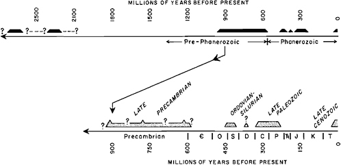
FIGURE 6.1 Occurrence in time of ancient ice ages plotted linearly, to two scales. O, Ordovician; S, Silurian; D, Devonian; C, Carboniferous; P, Permian; Tr, Triassic; J, Jurassic; K, Cretaceous; T, Tertiary.
huge continental ice sheets, smaller ice caps, piedmont ice sheets or aprons, and alpine glaciers confined to mountain ranges.
Where glaciers reach the sea, icebergs calve and float away, carrying within them clots of debris including large boulders. This debris drops to the seafloor when the ice melts and may accumulate in an environment where currents are weak and where thin-bedded or laminated deposits are being laid down. Ancient deposits of laminated shales with sporadic large stones, or clots of unsorted debris, may therefore be properly interpreted as the result of rafting. If these drop-stones in turn are large and angular and are composed of mixed rock types carried from great distances, and especially if some of them are glacially faceted and straited, we can infer that the rafts were thick icebergs from calving glaciers rather than thin sheets of shore ice or sea ice. Root mats and kelp holdfasts may also raft oversized stones and debris to environments of laminated deposition but are not so efficient as ice. In the Precambrian, however, plants did not yet exist, so ice rafting is confidently inferred.
Another sedimentary facies indicative of glaciation consists of thick deposits of massive diamictite containing widely dispersed stones. The stones may have been emplaced either by rafting or by downslope mixing. If some of these stones are glacially faceted and straited, it is especially reassuring for the glacial interpretation. Such deposits accumulated around the margins of Antarctica in the Ross and Weddell Seas during the late Cenozoic. Here glacial detritus is deposited in water deepening irregularly toward the deep sea and in part beneath ice shelves extending seaward from the eroding land (Kurtz and Anderson, 1979). Similar facies are identified in Late Paleozoic strata in the Falkland Islands, in the southern Cape Ranges of South Africa, in the Sentinel Range of Antarctica, and in Precambrian strata of the western United States (Crowell and Frakes, 1975; Blick, 1976).
Features preserved within the sedimentary strata range from those features clearly indicative of glaciation where erosion and deposition occur directly beneath glaciers in contrast to features at great distance from the glaciers themselves. Near-glacier features such as eskers, kettle holes, englacial and subglacial stream deposits, and patterned ground formed by seasonal freezing and thawing in terrains marginal to glaciers, for example, are identified in some ancient rocks. Some features, however, are difficult to interpret. Twisted and folded sand lenses within massive diamictite may have formed either by the bulldozing of an advancing glacier or by sliding down submarine slopes where nearby glaciers played no part. Continuing research on the modern and Pleistocene glacial and periglacial environments will help in characterizing ancient environments.
Studies of the Late Cenozoic Ice Age, both of the land record of the advance and retreat of ice sheets and of the distribution of ice-rafted debris in deep-sea cores, provide helpful clues in interpreting the more ancient rock record. Ice-rafted dropstones and debris have been recovered from the middle latitudes of all oceans. The conclusion follows that currents can carry icebergs great distances. Debris now dropped from melting icebergs on the Grand Banks south of Newfoundland, for example. have drifted in currents mainly from west Greenland glaciers. The nearest land (Newfoundland and
Nova Scotia) is not the source because at present these regions are free from ice caps. Ancient strata containing glacial drop-stones demonstrate the existence of glaciers somewhere. If the beds can be dated adequately, the timing of the glaciation can be determined, but the ice source can be located with confidence only when much is known about the paleogeography and the patterns of ancient ocean currents. This confidence will depend in turn on confidence in our environmental interpretations from the strata, on our regional tectonic reconstructions, and on our ability to correlate strata over great distances so that we are dealing with relatively synchronous shreds of data. As we go back farther and farther into the past, strata containing the evidence have been eroded away or covered up, or deformed and metamorphosed, so that the older the beds the less able we are to deal with time synchroneity and the less confidence we have in our reconstructed geography.
In examining the record of ancient ice ages, it may be difficult to distinguish between continental ice sheets, ice caps, and mountain glaciers. Tectonic reconstructions may indicate that plate convergence took place near the preserved strata, and so we may infer with confidence that alpine glaciers prevailed. Such a situation exists today along the coast of Alaska, where glaciers in high mountains next to the sea debouch debris onto a narrow coastal shelf and then seaward into deep sedimentation troughs. If, on the other hand, the record lies at the margin of a shield area, and deposition took place within a sedimentary prism marginal to it, an ice sheet is more likely. This situation existed around the periphery of the Scandinavian ice caps during the Pleistocene Epoch. Clast types within the diamictites or dropstone facies may also be helpful in such interpretations. Shields yield mature sedimentary rocks from a variety of granitic, gneissic, migmatitic, and similar sialic types; arcs rising inboard on continents from a convergent plate boundary are likely to yield calcalkaline volcanic and granitic debris to make immature sediments. The regional tectonic environment must therefore be reconstructed carefully as the glacial record is evaluated.
In working out the timing of such paleogeographic reconstructions, stratigraphic methods are first employed to find the age of the beds that contain the glacial record. For Phanerozoic beds, fossils are useful, but fossils within glacial beds are rare at best and may have been reworked from older deposits. The strata that are indisputably glacial are usually terrestrial and only locally contain marine fossils, which are most helpful for worldwide correlation. The strata lying above pavements scoured by glaciers are probably those laid down as lodgment till as the glaciers dwindled and retreated and as the sediments encroached landward across previously glaciated terrain. Their age will therefore document the ending of the glaciation rather than its maximum or its beginning. As an ice cap grows into a widespread ice sheet, the sediments brought to its margin are quickly worked over by outwash streams before reaching the sea. Sediments laid down at the same time, but at a distance within a basin where the sedimentary record is more complete, will contain little if any imprint of the glaciation. Stones and sand grains have been worn by river, beach, and marine processes so that no vestige of the glacial history may remain. Only when an ice sheet has grown so that tongues of ice reach the sea will icebergs calve to drift away in currents, to leave on melting a record within a distant sedimentary section, Sedimentary sections peripheral to glacial centers therefore need special scrutiny. In fact, since the direct evidence of continental glaciation is sparse at best, we need to employ indirect observations such as results from changes in sea level and attempt to interweave arguments from many sources, including paleomagnetism, as we reconstruct the geography during ancient ice ages (Crowell, 1978).
ICE AGES THROUGH TIME
Ice ages on Earth are first documented about 2300 m.y. ago (Ma), followed by an immensely long interval of about 1300 m.y., when, so far as we now know, none took place (Figure 6.1). Several glaciations occurred in the Late Precambrian and several during Paleozoic time until the Late Permian about 240 Ma. Continental ice sheets then disappeared and only began to wax again beginning about 25 Ma. We are still living during an ice age, but during one of the mild interglacial fluctuations within it. Continental glaciers have therefore come and gone on the Earth (Hambrey and Harland, 1981).
An early widespread glaciation between 2500 and 2100 Ma is documented in what is now southern Ontario, and the ice sheet may have reached as far as southern Wyoming (Young, 1970). In Canada, the Huronian glacial sequence includes several tillite horizons and dropstone facies and locally overlies a striated pavement. In South Africa a similar glaciation may also be recorded (Visser, 1971), but investigations have not gone far enough to demarcate paleogeography, and the dating is uncertain—somewhere between 2720 and 2200 Ma. Possible tillites are also reported from western Australia (Trendall, 1976). At present we can be reasonably sure that glaciation affected North America and perhaps other distant regions between 2700 and 2100 Ma but probably not continuously for this entire time, a span of 600 m.y., which is as long as all of Phanerozoic time, There may have been several glaciations during this long interval, and outstanding questions remain, concerning not only the nature, extent, and timing of these most ancient of recorded ice ages but also why there is no record of continental glaciation during the ensuing billion years.
In the late Precambrian, continental glaciation flourished intermittently from about 950 Ma to about 560 Ma (the beginning of the Paleozoic) (Harland and Herod, 1975; Williams, 1975). During this interval of about 400 m.y., ice sheets lay upon all the continents (with the possible exception of Antarctica) and at places waxed and waned more than once. Unfortunately, dating through either fossils or isotopic methods is uncertain so that we do not know whether distant strata are of the same age. Data now in hand, however, suggest three glaciation peaks: one about 940 Ma, another near 770 Ma, and a third near 615 Ma (Williams, 1975). Two of the three glacial culminations are recorded within the same
stratal sequence in regions around the present North Atlantic; in central and southwestern Africa; and in Brazil, western North America, and Australia.
Near the end of the Ordovician Period, and lasting into the Silurian, continental glaciation left an incontrovertible imprint on Gondwana, especially in northern Africa (Beuf et al., 1971). The record extends in scattered localities from northern Europe to South Africa and from the Saharan region to Bolivia and Peru (Harland, 1972; Frakes, 1979; Crowell et al., 1980). This refrigeration was introduced by cold-water faunas of Early Ordovician age in northern Europe, culminated during the latest Ordovician (Ashgillian) in Saharan regions, and then reached into Andean South America during the Early Silurian (Wenlockian and part of Ludlovian). This ice age is therefore recorded over a time span of about 50 m.y. between 400 and 450 Ma. In addition, probable glacial sediments of mid-Devonian age (about 365 Ma) are reported from the Amazon Basin (Caputo et al., 1972).
The Late Paleozoic Ice Age, recorded on all Gondwana continents, lasted for about 90 m.y., from 330 to 240 Ma (Crowell and Frakes, 1970, 1975; Crowell, 1978). It began in South America, culminated over much of Gondwana, and ended in Australia. On each continent the glacial record is preserved around the margins of deeply eroded sialic shields and within local basins. In Australia, six or more ice centers are suggested, but paleontological control does not allow determining whether they were all flourishing at the same time or at somewhat different times. In Antarctica, glaciers primarily lay adjacent to the now Transantarctic Mountains and also just south of the Sentinel Range. In Africa, several ice lobes reached into South Africa and Namibia from the interior, and farther north ice extended into the Congo Basin from the east and also occupied the vicinity of Gabon. On the east, lobes extended into southern Madagascar. In South America, ice tongues from Africa reached into Brazil and Uruguay and left a convincing and detailed record in the Parana Basin. Centers also accumulated over Paraguay and adjacent Bolivia, the Pampean Ranges, at several places in Argentina, and in the Falkland Islands. In Asia, ice caps bordered several of the basins in northeastern and central India and along a belt marginal on the south to the present Himalayan Ranges and were sited as far northwest as central Pakistan. In the Verkoyansk region of northeastern Siberia, mid-Permian beds may also record refrigeration. Although the record of the Late Paleozoic glaciation is widespread it is likely that ice caps came and went during the long span of 90 m.y. inasmuch as sea level was not drastically lowered, as would have been the case with one huge ice cap. Moreover, cyclic sedimentation (cyclothems) on distant continents, as in North America and Europe, suggest that slight fluctuations in sea level were caused both by the waxing and waning of ice caps and by the replacement by new ice centers as old ones melted away.
The Late Cenozoic Ice Age began slowly and locally in the Paleogene with the growth of the Antarctic Ice Cap, and by early-Miocene time, about 22 Ma, worldwide refrigeration had set in (Frakes, 1979, p. 223). Cooling continued, so that by 3 Ma sea-level glaciation is recorded in Iceland and within cores recovered from the floor of the Labrador Sea. The pattern of ice sheets around the Arctic and reaching southward, so characteristic of the Pleistocene Period, had already developed.
CAUSES OF GLACIATION
Explanations for ice ages fall into two groups: those based on extraterrestrial influences and those resulting from changes on Earth itself (Crowell and Frakes, 1970). Variations in solar radiation conceivably could cause glaciations, but as yet there is no evidence that fluctuations in solar heat output have been greater than a few percent (Jerzykiewicz and Serkowski, 1968). Heat arriving at the Earth might also be reduced if the Earth were to pass through a dust cloud, but there is no evidence for this either. Although we do not yet understand the extent of normal variations in the Sun’s heat flux, we must at present look to changes on Earth for the basic causes of ancient ice ages.
Variations in the geometry and mechanics of the Earth-Sun system are now well established (Broecker, 1965; Imbrie and Imbrie, 1980). The precession of the equinoxes with a period of about 21,000 yr, changes in the obliquity of the ecliptic over 40,000 yr, and variations in the eccentricity of the orbit over about 96,000 yr introduce climatic variations that are detected in the Late Cenozoic record and largely account for the glacial and interglacial stages. Such orbital influences on the amount and pattern of distribution of heat received by the Earth have certainly operated back into the readable geologic past. They are considered here as part of the noise’ superimposed upon changes taking place on the Earth itself. Whether there are significant longer cycles seems doubtful at present. The record of ancient ice ages as plotted in Figure 6.1 apparently is too irregular to contain effects of some cosmic cycle.
The changing arrangement of continents has long been advocated as influential in bringing about climatic change including glaciation and with the evolution of the concepts of plate tectonics has received new attention (Crowell and Frakes, 1970). With continents in polar or subpolar sites, and otherwise appropriately located so that uplands acrete snow from year to year to build up an ice cap, glaciation ensues. Studies in paleomagnetism show that during the Paleozoic, for example, continents with a record of glaciation also occupied a high-latitude position (McElhinny, 1973). As the united supercontinent of Gondwana drifted across the south poles, glacial centers roughly followed the migrating poles. Despite incompleteness of paleomagnetic data and controversy concerning interpretation, recently published apparent wander paths (Figure 6.2) cross glacial sites in chronological order throughout the Paleozoic Era (Morel and Irving, 1978). For glaciations during the Paleozoic and Late Cenozoic, the polar hypothesis is supportable.
Between Late Permian and Late Paleogene times, however, there is no record of continental glaciation, even though Antarctica occupied a position at or near the south pole. Dur-
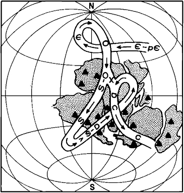
FIGURE 6.2 Apparent polar wander path for Gondwana for the Paleozoic Era. Redrawn and simplified from Morel and Irving (1978, Figure 1). Glacial strata, with ages appropriate to the apparent polar wander path, are shown with black triangles. Data on occurrence of glacial strata from many sources. X, alternative path. The close association of the glacial beds to the south polar position, for the different geologic periods (as indicated by the letters as in Figure 6.1), supports the concept that continental ice sheets developed when their sites were in near-polar positions.
ing most of this long interval the north pole lay within an Arctic Ocean or nearby and in a position not too different from that of today (Smith and Briden, 1977). Other factors therefore must have played a role in accounting for the lack of glaciation. Among these are sea-level changes. With marked raising of sea level so that continents are widely flooded, the albedo of the Earth is reduced, with the result that the Earth is warmed. Perhaps this is related to a speeding up of seafloor spreading (Pitman, 1978). In addition, during the Mesozoic Era, continents were arranged differently from that before and after so that the oceanic circulation followed different paths in both low latitudes and high latitudes. These changing continental arrangements in turn affected the heat exchange between the equatorial regions and the polar regions. With warm water in high latitudes, evaporation is facilitated so that snow on nearby continental sites is enhanced (Crowell and Frakes, 1970). When the continents are arranged so that the latitudinal flow is reduced and longitudinal flow enhanced, a different pattern of heat exchange between equatorial and polar regions follows.
The air-ocean system that controls climate on land is complex and beset with feedbacks. Many interrelated factors interweave to account for climate, and as these factors change, so does the climate. For example, the Earth’s albedo will rise when clouds are plentiful, but the average temperature at the surface may increase because of trapped infrared radiation. Albedo will increase when inland seas are frozen and when the ground is snow covered in the middle latitudes.
Back in time for the last half billion years the air-oceancontinent system apparently operated dynamically as it does today, although we still do not understand the complex interweaving of the many forcing factors. Back that far the record of climate and life on Earth, including glaciation, can be explained in terms of processes operating today, in nearly the same balance, but with still ill-defined variability. In the late Precambrian, however, a body of evidence from paleomagnetism suggests that continental glaciation occurred at low latitudes (Tarling, 1974; McWilliams and McElhinny, 1980), for which as yet no satisfactory explanation has come forth. In fact, an important reason for studying the climatic history during the long interval of recorded Earth history is to document the extreme ranges in flucuations of the air-oceancontinent system. Documentation of this record will then provide mankind with better understanding of the causes of variations, including those to be expected in the future. Such investigations will aid significantly in arriving at a satisfactory theory to explain climate and especially climate change.
REFERENCES
Beuf, S., B.Biju-Duval, O.DeCharpal, P.Rognon, O.Gariel, and A. Bennacef (1971). Les Grès du Paléozoïque Inférieur au Sahara—Sédimentation et Discontinuities, Evolution Structurale d’un Craton, Inst. Fr. Pétroles-Sci. Tech. Pétroles 18, 454 pp.
Blick, N.H. (1976). Late Proterozoic glaciation: Evidence in Sheep-rock Mountains, Utah, Geol. Soc. Am. Abstr. Programs 8, 783–784.
Broecker, W.S. (1965). Isotope geochemistry and the Pleistocene climate record, in The Quaternary of the United States, H.E. Wright, Jr., and D.G.Frey, eds., Princeton U. Press, Princeton, N.J., pp. 737–753.
Caputo, M.W., R.Rodrigues, and D.N.N.de Vasconcellos (1972). Nomenclatura estratigrafica da bacia do Amazonas, An. XXVI Congr. Bras. Geol., Soc. Bras. Geol. 3, 35–46.
Crowell, J.C. (1957). Origin of pebbly mudstones, Geol. Soc. Am. Bull. 68, 993–1010.
Crowell, J.C. (1978). Gondwanan glaciation, cyclothems, continental positioning, and climate change, Am, J. Sci. 278, 1345–1372.
Crowell, J.C., and L.A.Frakes (1970). Phanerozoic ice ages and the causes of ice ages, Am. J. Sci. 268, 193–224.
Crowell, J.C., and L.A.Frakes (1975). The late Paleozoic glaciation, in Gondwana Geology, K.S.W.Campbell, ed., Australian National U. Press, Canberra, pp. 313–331.
Crowell, J.C., A.C.Rocha-Campos, and R.Suarez-Soruco (1980). Silurian glaciation in central South America, in Gondwana Five, M.S.Cresswell and P.Vella, eds., Proc. Fifth International Gondwana Symposium, Wellington, New Zealand, February 1980, pp. 105–110.
Dott, R.H., Jr. (1963). Dynamics of subaqueous gravity depositional processes, Am. Assoc. Petroleum Geol. Bull. 47, 104–128.
Frakes, L.A. (1979). Climates Throughout Geologic Time, Elsevier, Amsterdam, 310 pp.
Hambrey, M.J., and W.B.Harland (1981). Earth’s pre-Pleistocene Glacial Record, Cambridge U. Press, Cambridge, 1004 pp.
Harland, W.B. (1972). The Ordovician ice age, Geol. Mag. 109, 451–456.
Harland, W.B., and K.N.Herod (1975). Ice ages: Ancient and modem, Geol. J. Spec. Issue No. 6, A.E.Wright and F.Moseley, eds., Sell House Press, Liverpool, pp. 189–216.
Imbrie, J., and J.Z.Imbrie (1980). Modeling the climate response to orbital variations, Science 207, 943–953.
Jerzykiewicz, M., and K.Serkowski (1968). A search for solar variability, in Causes of Climatic Change, J.M.Mitchell, Jr., ed., Am. Meterol. Soc. Meterol. Monogr. 8, no. 30, pp. 142–143.
Kurtz, D.D., and J.B.Anderson (1979). Recognition and sedimentologic description of Recent debris flow deposits from the Ross and Weddell Seas, Antarctica, J. Sedimentary Petrol. 49, 1159–1170.
McElhinny, M.W. (1973). Palaeomagnetism and Plate Tectonics, Cambridge U. Press, Cambridge, 358 pp.
McWilliams, M.O., and M.W.McElhinny (1980). Late Precambrian paleomagnetism of Australia: The Adelaide geosyncline, J. Geol. 88, 1–26.
Morel, P., and E.Irving (1978). Tentative paleocontinental maps for the early Phanerozoic and Proterozic, J. Geol. 86, 535–561.
Pitman, W.C., III (1978). Relationship between eustacy and stratigraphic sequences, Geol. Soc. Am. Bull. 89, 1389–1403.
Smith, A.G., and J.C.Briden (1977). Mesozoic and Cenozoic Paleocontinental Maps, Cambridge U. Press, Cambridge, 63 pp.
Tarling, D.H. (1974). A paleomagnetic study of Eocambrian tillites in Scotland, J. Geol. Soc. London 130, 163–177.
Trendall, A.F. (1976). Striated and faceted boulders from the Turee Creek Formation—evidence for a possible Huronian glaciation on the Australia continent, Geol. Surv. W. Australia, Ann. Rept., pp. 88–92.
Visser, J.N.J. (1971). The deposition of the Griquatown Glacial Member in the Transvaal Supergroup, Trans. Geol. Soc. South Africa 74, 186–199.
Williams, G.E. (1975). Late Precambrian glacial climate and the Earth’s obliquity, Geol. Mag. 112, 441–544.
Young, G.M. (1970). An extensive early Proterozoic glaciation in North America? Palaeogeogr. Palaeoclimatol. Palaeocol. 7, 85–101.


