
11
Water Resources and the Global Hydrologic Cycle
OVERVIEW
The global water cycle describes the circulation of water—a vital and dynamic substance—in its liquid, solid, and vapor phases as it moves through the atmosphere, the land, and the rivers, lakes, and oceans. Water affects everything—animal, vegetable, and mineral—on the surface of Earth and in the oceans. Life in its many forms exists because of water, and humans have flourished as a hydraulic civilization. Modern civilization depends on learning how to live within the constraints imposed by the availability of water—its excesses and its deficiencies (Figure 11.1).
Water is the link among most dynamic processes on land. It controls the growth of plants through water availability related to soil moisture and through radiation reaching the land surface—controlled largely by clouds—that is available for photosynthesis. Evaporation and transpiration from plants act to transfer not only water vapor but also energy from the surface to the atmosphere, enabling a feedback that has important implications for precipitation over global land areas. The carbon, water, and energy cycles are strongly interdependent—latent heat flux is essentially proportional to evaporation, and photosynthesis is closely related to transpiration.
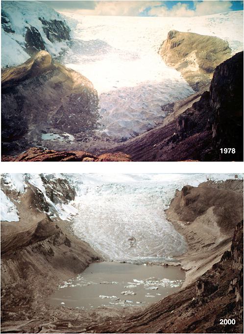
Snow cover, glaciers, and sea ice affect climate through feedback between reflected solar energy and temperature. This feedback effect exists not only over the polar areas but also more seasonally or ephemerally over much of the Northern Hemisphere’s land area as well as high-elevation areas of the Southern Hemisphere. Glaciers and ice sheets store much of the freshwater on the planet, but changes in such storage occur on timescales of decades to centuries. The melting of ice sheets (mostly in Antarctica and Greenland) is a major contributor to sea-level rise, and mid- and low-latitude glaciers, although much smaller in comparison with polar ice storage, are important contributors to water supply in some parts of the globe. Those glaciers are almost all in retreat, and this will eventually lead to a loss of this source of usable water (see, e.g., Figure 11.2).
On a global scale, there are important gaps in knowledge of where water is stored, where it is going, and how fast it is moving. Global measurements from space open a vision for the advancement of water science, or hydrology. This vision includes advances in understanding, data, and information that will
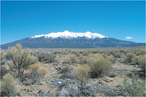
FIGURE 11.1 Water in many parts of the United States, especially in the Southwest, is a critically scarce resource for most of the year. This view of the Snake Range was taken along the Great Basin National Park access road. Great Basin National Parkin eastern Nevada is known for its ecological diversity ranging from low, desert basin to high, alpine tundra, with many ecozones and habitats in between. SOURCE: Courtesy of the U.S. Geological Survey.
improve the ability to manage water and to provide the water-related infrastructure that is needed to provide for human needs and to protect and enhance the natural environment and associated biological systems.
The scientific challenge posed by the need to observe the global water cycle is to integrate in situ and space-borne observations to quantify the key water-cycle state variables and fluxes. The vision to address that challenge is a series of Earth observation missions that will measure the states, stocks, flows, and residence times of water on regional to global scales followed by a series of coordinated missions that will address the processes, on a global scale, that underlie variability and changes in water in all its three phases.
The accompanying societal challenge is to foster the improved use of water data and information as a basis for enlightened management of water resources, to protect life and property from effects of extremes in the water cycle—especially droughts and floods. The recent western U.S. drought (see Box 11.1) has renewed a focus on more effective management of water resources in the perennially water-stressed West. More generally, a major change in thinking about water science that goes beyond its physics to include its
|
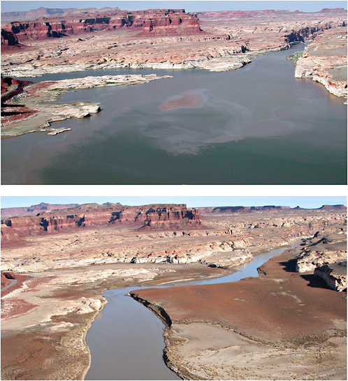
BOX 11.1 DROUGHT IN WESTERN NORTH AMERICA Drought is a nebulous concept for which there is no universal definition. All definitions—whether based on precipitation, soil moisture, or availability of water in rivers or reservoirs—are ultimately driven by conditions of abnormally low precipitation or high evaporative demand. Those conditions are particularly chronic in the western United States where water is scarce. The settlers of the 1800s found,for instance, that although land was in ample supply, the success of settlements depended heavily on ample rainfall. Post-Civil War settlers flourished during a period when precipitation generally was ample, but immense hardship followed in the generally dry decade of the 1880s. In modern history, the Dust Bowl years of the 1930s made an indelible impression on a generation of Americans. Although the 1930s drought was not restricted to the West (see Figure 11.1.1), its implications were most serious there (few of the major water systems now in place existed then). The drought of the 1950s was also widespread, but its effects were felt more in the Great Plains region than in the far West. The most recent western U.S. drought began in the late 1990s and persisted for at least 5 years over parts of the region. It has resulted in damages estimated at tens of billions of dollars. Reservoirs in the Colorado River system in particular have declined to near record low levels (see Figure 11.1.2). An important property of droughts in arid and semiarid regions is that small decreases in precipitation can produce large decreases in runoff. Figure 11.1.3 shows stream flow in the Rio Conchos River of northern Mexico, a major tributary of the Rio Grande. During the 1990s, precipitation fell short of its long-term average by only about 10 percent. Runoff, however, fell by about 50 percent. In contrast, in humid basins, a 10 percent dropoff in precipitation would produce only about the same decrease in runoff, which helps to explain why the severity and duration of droughts tend to be greater in the western than in the eastern United States. 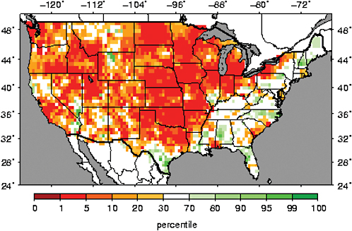 FIGURE 11.1.1 Drought extent in August 1934. Soil-moisture percentiles expressed relative to 1960–2003 climatology. SOURCE: See www.hydro.washington.edu/forecast/monitor.shtml. Courtesy of Land Surface Hydrology Research Group, University of Washington. |
|
Industrialized societies have generally become less susceptible to drought because of their ability to provide buffers to water supply in the form of either reservoir storage or groundwater. Short, 1- or 2-year droughts in the Colorado River basin are barely noticed, for instance, because total reservoir storage exceeds four times the mean annual flow. But the explosion of population in the “sunshine belt” of the Southwest is changing the balance of supply and demand, and the western states have been more aggressively pursuing management options, including drought plans. Basic sources of hydrologic data that allow “nowcasting” and forecasting of drought evolution that are required for effective drought response are incomplete. Among the key deficiencies is information about the space-time distribution of soil moisture and snow-water storage—information that is nearly impossible to obtain from in situ sensors but would be produced by the SMAP and SCLP mission concepts proposed in the section “Prioritized Observation Needs.” 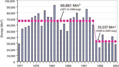 FIGURE 11.1.3 Rio Conchos discharge, 1955–2001. The 1993–2001 discharge was less than half that of 1955–1992 and included the 3 lowest discharge years on record, but precipitation over the same period was only about 10 percent below the long-term mean. SOURCE: After Vigerstol (2002). Courtesy of Kari Vigerstol. |
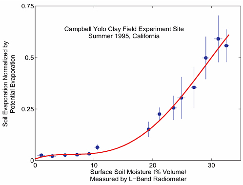
FIGURE 11.3 Soil moisture exerts substantial control on evapotranspiration in terrestrial ecosystems. Field measurements of soil moisture by a truck-mounted L-band radiometer are plotted with normalized evapotranspiration flux in a California agricultural field. As the soil becomes drier, the flux is reduced. Evapotranspiration is the key flux that links the water, energy, and carbon cycles in terrestrial ecosystems. SOURCE: Dara Entekhabi, Massachusetts Institute of Technology, after Cahill et al. (1999).
role in ecosystems (Figure 11.3) and society is also required. Better water-cycle observations, especially on the continental and global scales, will be essential.
Water-cycle predictions need to be readily available globally to reduce loss of life and property caused by water-related natural hazards, notably floods (see Box 11.2) and droughts. The panel envisions a future in which surface, subsurface, and atmospheric water will be tracked continuously in time and space over the entire globe and at resolutions useful for timely inclusion into models for prediction and decision support related to use of water for agriculture, human health, energy generation, and hazard mitigation. Space-based observations and supporting infrastructure can help to make that vision a reality for the next generation. Such predictions will have enormous social and economic value for the management of water, food security, energy production, navigation, and a range of other water uses.
SCIENCE AND APPLICATIONS NEEDS AND REQUIREMENTS
The previous section offers a rationale for the importance of understanding the global water cycle as a major feature both of the Earth system and of human society. This section presents a strategic overview of planned and new water-cycle missions and mission concepts that the Panel on Water Resources and the Global Hydrologic Cycle believes should constitute the U.S. water-cycle observing system from space over the decade 2010–2020. It also reviews the status and heritage of planned missions and programs that are the underpinnings of the new mission concepts described in the section “Prioritized Observation Needs” below. The primary focus in this respect is on the Global Precipitation Measurement (GPM) mission and the National Polar-orbiting Operational Environmental Satellite System (NPOESS), for which the panel offers recommendations on the basis of issues of immediate urgency to both programs.
Observing the Global Water Cycle: A Strategic View
Precipitation arguably is the most important part of the global water cycle. It dominates the land-surface branch of the water cycle and is, in terms of magnitude, second only to evaporation over the oceans. Furthermore, because the fraction of Earth covered by oceans is so large, even relatively small changes in the net of oceanic evaporation minus precipitation can lead to large changes in precipitation over adjacent land areas, and so, indirectly, ocean precipitation strongly affects land conditions.
Over the last decade, the ability to observe and thereby understand the dynamics of tropical precipitation has advanced immensely. Much of the advancement is attributable to the launch of the Tropical Rainfall Monitoring Mission (TRMM) in 1997 and the continuing data stream it has provided for over 9 years. The improved understanding that has been gained by flying active and passive microwave sensors on the same platform has been instrumental in better characterizing precipitation not only from the TRMM sensors but also from operational sensors, such as the Special Sensor Microwave Imager (SSM/I). Those improvements have come from a better understanding and interpretation of brightness temperature (Tb) information at wavelengths that are most sensitive to precipitation. The improved understanding has also translated into better precipitation products from the Advanced Microwave Scanning Radiometer-EOS (AMSR-E) sensor on Aqua and forms the basis of the approved GPM mission.
The success of precipitation measurements from space forms a blueprint for strategic thinking about observation of “fast” storage terms in the global hydrologic cycle, such as moisture storage in soil, in rivers, lakes, reservoirs, and wetlands, and as ephemeral snow. While estimates of soil moisture are routinely produced from the AMSR-E sensor, their quality is at best experimental (the wavelength is too short to produce good soil-moisture estimates for all but sparsely vegetated areas), and the AMSR-E soil-moisture product is insufficient to constrain the surface hydrologic models in any useful way. The same is true for snow-water equivalent, especially in mountainous terrain, which is critical for the water resources of many parts of the globe, such as the western United States. Here, the issue has to do primarily with spatial resolution. Aside from very large inland water bodies, which are captured by such ocean altimeters as Ocean Topography Experiment (TOPEX)/Poseidon and Jason, surface-water variations are not captured by current sensors. Estimation of river discharge from space remains an elusive goal.
Having high-quality estimates of those variables, coupled with measures of surface-water storage and transport, would substantially improve the ability to model and understand the amounts and flows of surface water and in turn to provide an integrated understanding of the water cycle globally. The four highest-ranked water-cycle missions (listed in rank order) would contribute to that goal as follows:
-
The approved GPM mission will provide estimates of precipitation at a sampling interval (3–4 h) sufficient to resolve the diurnal cycle and at a spatial resolution sufficient to resolve major spatial variations over the continents and oceans.
-
A soil moisture mission would provide estimates of a key part of the land-surface water balance, which controls land-atmosphere fluxes of heat and water over many parts of the globe (in particular, recycling of moisture from the land to the atmosphere) and is a key variable that affects the nonlinear response of runoff to precipitation.
-
A surface-water and ocean-topography mission (see the section “Prioritized Observation Needs”) would provide observations of the amount and variability of water stored in lakes, reservoirs, wetlands, and river channels and would support derived estimates of river discharge. It would also provide critical information necessary for water management, particularly in international rivers.
-
A cold-season mission would estimate the water storage of snowpacks, especially in spatially heterogeneous mountainous regions that are the source of many of the world’s most important rivers.
Taken together, those four missions, described in some detail in the section “Prioritized Observation Needs,” would form the basis of a coordinated effort to observe most components of the surface water cycle globally. They also would provide critical information about precipitation over the world’s oceans and the basis for prediction of circulation in coastal areas that is not possible with current sensors.
In addition to measurements that would be made by these four missions, several measurements that would benefit analyses of the water cycle were highly rated by the water-cycle panel but with somewhat lower priority. They include missions that would estimate water vapor transport, sea ice and glacier mass balance, groundwater and ocean mass, and inland and coastal water quality (see Table 11.1). Those measurements and water-cycle issues are discussed in the section “Other High-Priority Water-Cycle Observations.” As discussed in that section, all the measurements have direct relevance to the measurement needs identified by other panels, and that synergy was considered in the selection of the integrated missions recommended in Chapter 3.
Summary of Existing and Planned Missions and Products
As noted in this chapter’s “Overview” section above, the queue of approved U.S. Earth science missions is sparse, especially those relevant to the global water cycle. It consists of CloudSat and Cloud-Aerosol Lidar and Infrared Pathfinder Satellite Observations (CALIPSO), launched in April 2006; the GPM mission, which was further delayed for more than 2 years by NASA in spring 2006 despite the decadal survey committee’s recommendation against further delays (NRC, 2005). Aquarius, which will measure ocean salinity and facilitate estimation of E—P (evaporation minus precipitation) over the oceans, is scheduled for launch in 2009. On the operational side, the staggering cost growth in NPOESS has resulted in cancellation or descoping of instruments that are central to water and climate science, including cancellation of the ocean altimeter and cancellation of the Conical-Scanning Microwave Imager/Sounder (CMIS). This section does not discuss the implications of CloudSat/CALIPSO, in light of its recent launch; however, it does address the necessity of and urgency for GPM and for measurement of certain key water-cycle variables that will be observed by NPOESS.
Global Precipitation Measurement Mission
Precipitation is the central component of the global water cycle. It regulates the global energy balance through coupling to clouds and water vapor (the primary greenhouse gas) and shapes global winds and
atmospheric transport through release of latent heat. Precipitation is also the primary source of freshwater in a world that is facing an ever more severe freshwater crisis. Accurate and timely knowledge of global precipitation is essential for improving the ability to manage freshwater resources and for predicting high-impact weather events, such as floods, droughts, and landslides.
The objective of GPM is to provide a reference standard for unifying a constellation of dedicated and operational microwave radiometers to provide accurate and frequent measurements of global precipitation for basic research and applications (Smith et al., 2006). The GPM core spacecraft will carry a first-ever, dualfrequency precipitation radar and a multifrequency microwave radiometric imager with high-frequency capabilities to serve as a precipitation physics laboratory (with detailed microphysical measurements) and a calibration standard for constellation radiometers in terms of brightness temperature measurements and precipitation retrievals. In addition, NASA will provide a constellation radiometer to be flown in an orbit that optimizes the sampling and coverage of global precipitation. GPM is thus the key to providing a uniform global-precipitation data product leveraging all available satellites capable of precipitation measurement. By extending the success of TRMM to the entire globe with new capabilities to measure rain, snow, and precipitation microphysics, GPM is poised to improve the understanding of the water cycle and the modeling and prediction of weather, climate, and hydrologic systems.
GPM is in formulation at NASA and the Japan Aerospace Exploration Agency (JAXA), with potential participation by other international space agencies. This is a complex international partnership, and any further delay in launching the GPM core spacecraft jeopardizes the mission by increasing the total cost and creating development problems for all partners. The viability of GPM will depend critically on NASA’s commitment to a firm launch schedule, thus providing a solid basis for securing international partnership. The president’s FY 2007–2008 budget supports a GPM launch in mid-2013 (rather than 2012, as suggested in NASA documents), which may further jeopardize the NASA-JAXA partnership. Maintaining the viability of the JAXA partnership adds another compelling reason for not delaying the GPM launch to 2013. As noted above, the decadal survey committee strongly recommended that GPM be launched without further delay (NRC, 2005), and the water resources panel repeats that recommendation here: The panel recommends that GPM be launched in a timely manner, without further delay.
NPOESS
NPOESS was originally intended to include several measurements that are of key importance to understanding climate and the global water cycle. They included snow-covered area, which would be measured at high spatial resolution by the Visible/Infrared Imaging Radiometer Suite (VIIRS), similar to the Moderate Resolution Imaging Spectroradiometer (MODIS) product, and at lower resolution (but all-weather, or nearly so) by CMIS; snow-water equivalent, by CMIS (similar to AMSR-E); soil moisture, by CMIS (6-GHz channel, assuming that AMSR-E radio interference problems at this frequency could be resolved, and otherwise at 10 GHz); ocean-surface height, by a nadir-pointing radar altimeter; and precipitation, by CMIS. In addition, NPOESS was to include the capability to measure ocean wind speed and direction (needed for estimation of water vapor transport) and all-weather sea-surface temperature (needed for evaporation estimation), both by CMIS. The CMIS instruments on all three NPOESS platforms were also intended to act as “constellation” satellites for GPM. The highest frequency (183 GHz) would facilitate retrievals of falling snow, not possible with AMSR-E or Defense Meteorological Satellite Program (DMSP) satellites. The recent cancellation of CMIS and problems with VIIRS call into question whether many of those observations will be made by NPOESS. The extent of the problem is difficult to determine until the nature of a downscaled CMIS replacement is known. However, it appears likely that the lowest-frequency channel or channels will be lost. That would eliminate all soil-moisture information that may have been available from CMIS.
|
BOX 11.2 FLOODS IN LARGE RIVERS—THE POTENTIAL FOR GLOBAL FLOOD FORECASTING Floods are among the most destructive of natural disasters. From a monetary standpoint, flood damages in the United States averaged around $5 billion per year in the 1990s in 1995 dollars (Table 3.1 in Pielke et al., 2002). Outside the United States, the impact is even more striking; flood losses globally increased 10-fold (inflation-corrected) over the second half of the 20th century to a total of around $300 billion in the decade of the 1990s (Kabat and van Schaik, 2003). Aside from the economic costs, the social consequences of flooding can be staggering. The Mississippi River flood of 1927 displaced over 700,000 people and had impacts on the social structure of the lower Mississippi River valley that persist to this day (Barry, 1997). Both the number of floods (Figure 11.2.1) and flood damages (in constant dollars) have been increasing in recent decades (UNDP, 2004). Although it is not clear whether climate change or increased economic development is playing a greater role in those changes (Pielke, 2005), the trend is of concern to both governments and the insurance industry. The magnitude of flood losses is generally greatest in the developed world (losses from the 1993 Mississippi River flood were estimated to be about $15 billion, and from the 2003 Elbe River flood about 9 billion Euros, or about $11 billion), but the impact—in terms of loss of life and economics—is greatest in the developing world. For instance, flooding associated with Hurricane Mitch caused an estimated $3 billion to $4 billion (U.S. dollars) in damages in Honduras, which was almost 70 percent of that country’s gross domestic product (GDP) (UNDP, 2004). In comparison, the 1993 Mississippi River flood damages represented less than 0.3 percent of the U.S. GDP. Most of the developed world has reasonably sophisticated flood-forecasting systems. They are based on a combination of precipitation-gauge and radar precipitation observations, river-stage observations, and hydrologic models coupled with quantitative precipitation forecasts derived from weather prediction models. However, the forecast systems are almost all regional. For instance, in Europe, each country has an agency (generally affiliated with the weather services) that is responsible for flood forecasts in that country. In the United States, flood-forecasting responsibilities lie with the National Weather Service River Forecast Centers, of which there are 13 (generally partitioned according to major river basins). On a global basis, there is no coherent flood-forecasting capability as there is for global weather (Lettenmaier et al., 2006). The absence of a global flood-forecasting capability affects the developing world especially. In the Mozambique flood of 2000, for instance (Figure 11.2.2), there were only a handful of precipitation stations reporting on the Global Telecommunications System, and the precipitation radar systems that are a key element of flood-forecasting systems in the developed world were nonexistent. But the capability for global flood forecasting clearly exists, particularly for large river floods, which are responsible for most loss of life and economic damages (Webster et al., 2006). Accurate flood forecasting requires good knowledge of the initial state of the land system (primarily soil moisture and, where relevant, snow-water storage) and river levels, an accurate forecast of the space-time dis 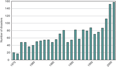 FIGURE 11.2.1 Number of major flood disasters globally, 1975–2001. SOURCE: Reprinted from UNDP (2004). Copyright 2004 United Nations, with the permission of the United Nations. |
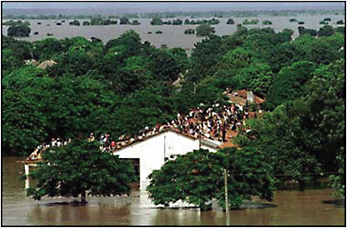 FIGURE 11.2.2 The Mozambique flood of 2000 flooded over 19,000 square miles at its maximum and damaged as much as 90 percent of the country’s irrigation infrastructure. Some 45,000 people were rescued from rooftops. SOURCE: AP/Wide World Photos. tribution of future precipitation, and an accurate hydrologic and river-routing model. The missions proposed the section “Prioritized Observation Needs” will especially improve the ability to estimate initial conditions for flood forecasting: the proposed SMAP soil-moisture mission will provide direct estimates of near-surface soil moisture, the SCLP cold-lands mission will provide estimates of snow-water storage, and the SWOT swath altimetry mission will provide estimates of initial conditions of river levels and floodplain storage. Other missions, such as atmospheric moisture profiles and transport, will also help to improve weather forecasts, especially in parts of the world where in situ (e.g., radiosonde) methods of measuring atmospheric profiles are sparse. Already, impressive advances have been made in the ability to “nowcast” precipitation in data-sparse parts of the globe (Figure 11.2.3), and these nowcasts (in combination with land-surface models) also help to estimate soil moisture, following approaches pioneered in the North American Land Data Assimilation System (Mitchell et al., 2004). Those advances, coupled with improved global water-cycle observations, not only will facilitate the development of flood forecasts globally but also will enhance the quality of existing forecasts in the developed world. 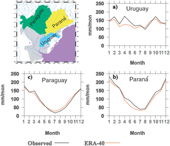 FIGURE 11.2.3 European Centre for Medium-Range Weather Forecasts’ 40-yr global reanalysis (ERA-40) and observed (from gridded station data) mean monthly precipitation for the Uruguay, Paraná, and Paraguay tributaries of La Plata River, 1979–1999. The figure suggests that weather-model precipitation-analysis fields (for which ERA-40 is a surrogate) offer a useful alternative to surface networks to force land-surface models and in turn to estimate initial soil moisture for flood forecasts. SOURCE: Lettenmaier et al. (2006). Reproduced courtesy of Fengge Su, University of Washington. |
The viability of the snow product (which is measured by using higher-frequency channels that may survive) is not known. Similarly, the effects on GPM are not known. The proposed extension of the Special Sensor Microwave Imager/Sounder will provide continued rainfall information, but its resolution and thus the quality of the retrieved rainfall products will be substantially degraded compared with CMIS.
Even in the absence of the CMIS difficulties, the NPOESS observations would have had serious limitations. The wavelengths (even with 6- and 10-GHz channels) are too short for soil-moisture estimating other than in areas of sparse (or low-biomass) vegetation. Hence, NPOESS would not obviate the need for a dedicated soil-moisture mission. The nadir-pointing ocean altimeter would not have addressed the needs outlined in the section “Sea Ice Thickness, Glacier Surface Elevation, and Glacier Velocity” of either the hydrology or the oceanography community for high-resolution swath altimetry. In particular, it would not have provided the spatial resolution required for inland-water and near-coastal applications or the two-dimensional profiles needed for bathymetric estimation. For snow, the resolutions are quite coarse (around 15 km) and will not work well in areas with complex topography or in forested areas. The cold-lands mission proposal is targeted specifically at those issues. Nonetheless, the NPOESS data over selected low-vegetation areas of modest topographic relief would be useful for validation of the cold-land mission observations. For ocean surface wind, the wind-direction measurements from CMIS would be poor at low wind speeds. Finally, the CMIS precipitation estimates would be much less useful without the “training” that would result from coincident observations from the planned GPM precipitation radar, which, as noted above, has been placed at risk by recent launch delays.
PRIORITIZED OBSERVATION NEEDS
The panel met for a total of 5 days to review and discuss the mission concepts submitted in response to the decadal survey committee’s request for information (RFI; see Appendixes D and E). Of 47 RFI responses that were screened for possible relevance to the water cycle (see Table 11.A.1 in the attachment at the end of this chapter), 20 were identified that were not of primary importance to other panels. Those 20 were reviewed and divided into two groups. The first group consisted of missions and instruments that are already slated to fly or are in orbit. They included Aquarius, MODIS/Flora, and GPM. The proposal to measure evaporation was dropped because the panel is not confident that this can be accomplished with existing technology. Nevertheless, the panel recognized it as a key need, and the section titled “Evaporation” is devoted to issues associated with measurement and prediction of evaporation over the oceans and land. Twelve mission concepts were aggregated from the remainder by combining proposals that could be adopted with data from the same sensors.
Table 11.1 summarizes the seven mission concepts identified by the panel in the order of their final ranking. Mission concepts were evaluated primarily from the perspectives of their potential contributions to science and to societal benefits. Secondary considerations were incremental mission cost, technology readiness, mitigation or backup for other missions, contribution to long-term monitoring, and consistency with multidisciplinary contribution to science or applications.
The panel conducted an iterative process of priority-setting, using the criteria noted above. The panel found that the rankings were quite stable with respect to inclusion of secondary criteria (ranking was ultimately based on equal weighting of the two primary criteria, scientific and societal benefits). The panel also found that the first three mission concepts ranked substantially higher than the other four, and for this reason the first three are described in greater detail than the subsequent four. The panel also reaffirmed the critical importance of GPM. GPM is an approved mission, but the panel consensus was that if it were not, then it would have the highest water-cycle priority, just as it did in the Easton post-2002 planning process (NRC, 1999).
TABLE 11.1 Water Resources Panel Candidate Missions in Rank Order
Soil Moisture and Freeze-Thaw State
Mission Summary—Soil Moisture and Freeze-Thaw State
|
Variables: |
Surface freeze-thaw state, soil moisture |
|
Sensors: |
L-band radar, radiometer |
|
Orbit/coverage: |
LEO/global |
|
Panel synergies: |
Climate, Weather |
|
Related RFI responses: |
WOWS (27), Hydros (56), MOSS (70) |
Mission Objectives and Technical Summary
The soil moisture mission concept (called SMAP, or Soil Moisture Active/Passive, in Parts I and II) is a Pathfinder-class concept for global mapping of soil moisture and its freeze-thaw state with sampling and accuracies that meet key requirements for water-, energy-, and carbon-cycle sciences; weather and climate applications; and natural-hazards decision-support systems. The technical approach is to make simultaneous active and passive low-frequency L-band microwave measurements. The radar makes overlapping measurements that can be processed to yield a resolution of 1–3 km. The radar and radiometer share a large, deployable, lightweight mesh reflector to make conical scans of the surface. That measurement approach allows passive microwave global mapping at 10-km resolution with 2- to 3-day revisit (Entekhabi et al., 2004). The SMAP concept draws heavily from the canceled Hydrosphere State Mission (Hydros) but would include enhancements.
Several RFI responses included the Hydros/SMAP measurement approach at their core but added frequencies to meet broader requirements. For example, the WOWS and water-cycle mission concepts would have additional and higher-frequency microwave channels for snow, ocean winds, salinity, precipitation, and other variables. The MOSS concept would add a lower-frequency (VHF) radar to allow deeper penetration sensing into the soil to characterize the root-zone soil-moisture profile. The VHF radar would also be capable of sensing through denser vegetation canopies. A key issue associated with VHF observations is the requirement for a very large (several tens of meters) antenna, technology for which is not yet developed. The deep-soil moisture measurements that the MOSS concept would support would be of great value to a range of science endeavors, but the panel felt that the technology is a key constraint and that the MOSS/VHF concept is better considered in the context of a broader long-term coordinated water-cycle observation strategy (see the section “Next-Generation Challenges” below).
Science Value
Over land, soil moisture (and its freeze-thaw state) is the key variable that links the water, energy, and biogeochemical cycles (NRC, 1991). Soil moisture is a key determinant of evapotranspiration. The availability of soil moisture data will assist the water, energy, and biogeochemistry communities by allowing the linking of these cycles over land regions.
In boreal latitudes, the switching on and off of the land-atmosphere carbon exchange is coincident with freeze-thaw transitions. Depending on the timing of the transitions, those areas can switch from a net source of carbon to a net sink. Such a transition, and its sensitivity to a warming climate, has been suggested as a possible component of the “missing sink” in carbon-cycle science (Myeni et al., 2001). A soil moisture mission will directly support science to reduce that major uncertainty.
Societal Benefits
Through its control of the rate of land-atmosphere exchange of water, soil moisture is a determinant of lower-atmosphere water vapor and buoyancy flux. Experiments have demonstrated that the position and intensity of severe weather and the forecasting skill of numerical weather prediction (NWP) models are extended when the model soil moisture state is realistically assigned (e.g., Chen et al., 2001).
Over land regions where seasonal climate prediction has the most societal value, soil moisture is a major determinant of the climate state. The recycling of precipitation over continental regions is an important feedback mechanism associated with persistent drought and flood events, and soil moisture is a key element of the feedback mechanism (e.g., Hong and Kalnay, 2000).
It is also a critical input into drought decision-support systems. Rather than using proxy data for soil moisture, as in most drought-monitoring systems, such as the Huang et al. (1996) model used by the NOAA Climate Prediction Center, SMAP will provide realistic and reliable soil moisture observations that will potentially open a new era in drought monitoring and decision support.
Floods depend on both the amount of precipitation and the soil infiltration conditions (see Box 11.2). The current practice of main-stem river flood forecasting and the delivery of flash-flood guidance to weather-forecasting offices depend heavily on the availability of soil moisture estimates and observations.
Complementarity
The soil moisture and freeze-thaw estimates from SMAP—as measurements of key components of the terrestrial hydrosphere—will contribute to the disciplinary sciences throughout the Earth system community. Because soil moisture determines rates of energy and moisture exchange between the land surface and atmosphere and is a critical measure of the terrestrial portion of the water cycle, numerous branches of basic and applied Earth science require this measurement, including operational weather applications, climate science and seasonal climate forecasting, and terrestrial ecology and carbon-cycle science.
The measurements would also allow all-weather high-resolution sea ice mapping and would provide knowledge of the soil background emissivity needed for snow-water equivalent retrievals and solid-Earth interferometry. Finally, for single looks, SMAP retrievals of ocean salinity would not be as accurate as those of a dedicated salinity mission (e.g., Aquarius). However, through averaging in time (and reduction of effective spatial resolution), SMAP would be able to provide temporal averages of ocean salinity that would meet the Aquarius salinity accuracy standard of 0.2 PSU (practical salinity unit) and would be the basis for estimating climatologic E—P over the oceans, which would be a useful constraint on two components of the global water balance.
Cost
The proposed SMAP soil moisture mission builds on significant system risk reduction performed for the previous AO-3 Earth System Science Pathfinder (ESSP) Hydros mission. The understanding of the system components and costs is mature. The Hydros components and system are all at technology readiness level 7 and higher. The end-to-end cost of formulation, implementation, launch, and operations is estimated to be about $300 million (in 2006 dollars). The radar and radiometer share a lightweight mesh deployable antenna with substantial cost savings. The antenna subsystem has already undergone cost and engineering analyses, including numerical and scale-model testing.
Long-Term Observations
Accurate and reliable soil moisture and surface freeze-thaw measurements will allow testing of complementary measurements (e.g., at 6 and 10 GHz) from current and planned (e.g., GPM and NPOESS) sensors. The SMAP data set will provide much more accurate and higher-resolution information than can be retrieved from those higher-frequency observations. The SMAP data will help to form a benchmark for determining where 6- and 10-GHz data (currently produced by TMI and AMSR-E and possibly in the future by NPOESS) are usable and their errors, so that at least partial global coverage (albeit not of the quality that SMAP will provide) will be possible past the end of the SMAP mission.
Multidisciplinarity
The global mapping of soil moisture has broad and important multidisciplinary benefits for ecosystem, weather, climate, and applications aspects of Earth systems. Ecosystems are limited primarily by soil moisture and its freeze-thaw state. Weather and climate forecasting models need mapped soil moisture observations as initial and boundary conditions. Many natural-hazards applications are affected by soil moisture status, for example, freshwater availability and supply, flood prediction, drought monitoring, and decision support for malaria and other waterborne diseases.
Readiness
The SMAP concept is built on the foundations of low-risk and proven components. The concept requires a large (6-m diameter) reflector to meet the resolution requirements. Existing lightweight mesh reflectors with space heritage are used for telecommunication. At L-band, those reflectors have very low emissivity and are suitable for making Earth observations with both active and passive sensors. The SMAP components and system are all at technology readiness level 7 and higher.
Surface Water and Ocean Topography
Mission Summary—Surface Water and Ocean Topography
|
Variables: |
River and lake elevation; ocean circulation |
|
Sensors: |
Radar altimeter, nadir SAR interferometer, microwave radiometer, GPS receiver |
|
Orbit/coverage: |
LEO/global |
|
Panel synergies: |
Climate, Ecosystems, Health, Weather |
|
Related RFI responses: |
Hydrosphere Mapper (56), OOLM (62), WaTER (108) |
Mission Objectives and Technical Summary
The Surface Water and Ocean Topography (SWOT) mission concept uses a radar altimeter that would measure the height of inland water surfaces (rivers, lakes, reservoirs, and wetlands) and the ocean. Over inland waters, the measurements are critical for determining the location of and changes in stored water (in reservoirs, lakes, wetlands, and rivers), which are needed for the effective management of water resources globally, and of its movement (in rivers). Furthermore, knowledge of changes in seasonally and ephemerally inundated areas (e.g., floodplains) is important scientifically for understanding carbon exchange with the atmosphere and the processes that affect floodplain evolution and biological processes in wetlands. Over
the oceans and coastal areas, dynamic ocean surface topography controls ocean currents, and knowledge of spatial variations in static surface topography can be used to infer ocean bathymetry.
The SWOT concept will provide images (as opposed to tracks, as are observed by all current and past altimeters) of water surface topography at very high resolution (about 10 m). When averaged over surface water areas of about 1 km2 and linear distances of 10 km for slope (assuming a 100-m-wide river channel), the images will provide surface topography measurements accurate to within several centimeters in vertical precision and one microradian for slope at repeat intervals of about 3 to about 21 days for latitudes up to 78°. The coverage will be nearly global for all latitudes lower than 78°, and there will be only small gaps around the equator, which will not affect the spatial coverage of rivers, lakes, or mesoscale activity (Figure 11.4). For rivers, the mission would also be intended to recover channel cross-sectional profiles to within 1 m vertical accuracy to low water, composited from multiple overpasses, which would provide a basis for estimation of the discharge of selected large (≥100 m wide) rivers through assimilation of surface elevation, slope, and channel cross section into river hydrodynamic models. For the ocean, the mission would measure mesoscale topography with a height precision of several centimeters over areas of less than 1 km2,
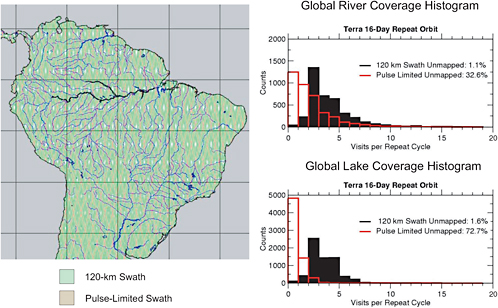
FIGURE 11.4 Spatial coverage of the proposed SWOT swath altimeter for a 16-day-repeat mission. The swath of the instrument is shown in green, and the nadir altimeter coverage is in red. The figures to the right show the coverage of rivers and lakes for the swath instrument (black) and the nadir instrument (red). Even at the equator, near-global coverage is achieved by the swath instrument, whereas most global lakes and rivers are missed by the nadir instrument. SOURCE: Alsdorf et al. (2007). Copyright 2007 American Geophysical Union. Reproduced by permission of American Geophysical Union.
depending on latitude. It would extend the current sea-level measurements into the coastal zones. A slope resolution of 1 microradian would also provide the basis for retrieval of global ocean bathymetry; small variations in gravitational attraction due to the contrast in density between seawater and the ocean crust are manifested in small slopes in ocean surface topography, which in turn allow retrieval of bathymetry when averaged over multiple overpasses to average tidal effects.
The mission concept included here is similar to the Hydrosphere Mapper (56) and WatER (108) RFI responses and is called SWOT (Surface Water and Ocean Topography) in Parts I and II. The main difference between SWOT and Hydrosphere Mapper/WatER is the use of the Ku rather than the Ka band for the swath altimeter (which results in improved performance during precipitation, with some reduction in vertical precision) and the use of a 21-day, rather than 16-day, repeat (10.5- and 8-day revisits, respectively) to avoid complications due to tidal aliasing for ocean retrievals. This section retains the original Hydrosphere Mapper configuration (Figure 11.5), but there are changes in SWOT as presented in Parts I and II.
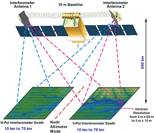
FIGURE 11.5 Conceptual drawing of the Ka-band Hydrosphere Mapper interferometer. Swaths on either side of nadir are mapped by horizontal (red) and vertical (blue) polarizations to avoid signal contamination. The spatial resolution will be 2 m in the along-track direction and will vary from 70 m in the near-nadir to 10 m in the far swath. SOURCE: Courtesy of Ernesto Rodriguez, jet Propulsion Laboratory.
The decision between the Ka (Hydrosphere Mapper/WatER) and the Ku (SWOT) band will require careful consideration and should be the basis of a study of tradeoffs.
To meet the science objectives, Hydrosphere Mapper would fly a suite of instruments on the same platform: a Ka-band near-nadir SAR interferometer (see Figure 11.5), a three-frequency microwave radiometer, a nadir-looking Ku-band radar altimeter, and a GPS receiver. The Ka-band SAR interferometer is the same as has been proposed for inland water applications (WatER) and draws heavily on the heritage of the Wide Swath Ocean Altimeter (WSOA) and the Shuttle Radar Topography Mission (SRTM). The Kaband synthetic-aperture radar interferometer would provide centimeter precision with a swath of 120 km (including a nadir gap). The nadir gap would be filled with a Ku-band nadir altimeter similar to the Jason-1 altimeter with the capability of synthetic-aperture processing to improve the along-track spatial resolution. Because the open ocean lacks fixed elevation points, additional sensors are required to attain the desired height precision: the microwave radiometer to estimate the tropospheric water vapor range delay, and the GPS receiver for a precise orbit. A potential side benefit is that the GPS receiver could in principle also be used to provide radio occultation soundings (see the section “Water Vapor Transport” below).
Orbit selection is a compromise between the need for high temporal sampling for surface-water applications, near-global coverage, and the swath capabilities of the Ka-band interferometer. A swath instrument is key for surface-water applications because a nadir instrument would miss most of even the largest global rivers and lakes. An additional issue is controlling the aliasing of ocean tides (or any other diurnal signal), for which the choice of a Sun-synchronous orbit is problematic.
To achieve the required precision over water, a few changes in the SRTM design are required. The major one would be reduction of the maximal look angle to about 4.3°, which would reduce the outer swath error by about a factor of 14 compared with SRTM. A key aspect of the data-acquisition strategy is reduction of height noise by averaging neighboring image pixels, which requires an increase in the intrinsic range resolution of the instrument. A 200-MHz bandwidth system (0.75-m range resolution) would be used to achieve ground resolutions varying from about 10 m in the far swath to about 70 m in the near swath. A resolution of about 5 m (after onboard data reduction) in the along-track direction can be achieved with synthetic-aperture processing.
To achieve the required vertical and spatial resolution, SAR processing must be performed. Raw data would be stored on board (after passing through an averaging filter) and downlinked to the ground. The data downlink requirements for all the ocean and land-water bodies can be met with eight 300-Mbps X-band stations.
Science Value
The change in water stored in lakes, reservoirs, wetlands, and stream channels, and the discharge of streams and rivers, are major terms in the water balance of global land areas. Yet both terms are poorly observed globally; observations of these variables are now provided almost exclusively by in situ networks whose quality and spatial distribution vary greatly from country to country. More important, even where the density of in situ gauges is relatively high, the point data are unable to capture the spatial dynamics of wetlands and flooding rivers (Alsdorf and Lettenmaier, 2003).
Over the open ocean, the scientific value of altimetric sea-level observations has been well established for ocean circulation, tides, waves, sea-level change, ice sheet dynamics, geodesy, and marine geophysics. A large body of scientific publications has resulted from TOPEX/Poseidon and Jason-1 missions (see, for example, Fu and Cazenave, 2001, and references therein). Nonetheless, despite the enormous contributions of nadir altimeters to the field, scientific understanding is limited, especially in coastal regions, by the
coarse (300-km) resolution of the measurements. The swath altimeter would provide a basis for estimating coastal currents, ocean eddies, and global sea level.
In addition to the benefits related to the land-surface water cycle and oceanography, a swath altimetry mission would have important scientific benefits related to weather and climate prediction, floodplain hydrodynamics, aquatic ecosystem and carbon dynamics, mesoscale currents and eddies, coastal processes, and ocean bathymetry. Furthermore, although the overpass frequency would not be sufficient for SWOT to fulfill a tsunami-warning function, in cases where SWOT overpasses would allow it to capture tsunamis these data could be extremely valuable for assessment of tsunami-prediction models.
Societal Benefits
The paucity of global measurements of surface water storage changes and fluxes limits the ability to predict the availability of water in the future and to predict flood hazards (IAHS, 2001). Furthermore, many major rivers cross international boundaries, but information about water storage, discharge, and diversions in one country that affect the availability of water in its downstream neighbors is often not freely available (e.g., Hossain and Katiyar, 2006). Major health issues, such as malaria, are also linked to freshwater storage and discharge. Yet there is no source of either archival or real-time observations of those highly dynamic and sometimes ephemeral water bodies. Many benefits of the mission would be global, but there are important applications within the United States. For instance, a large investment is being made in restoration of the Florida Everglades, a large free-flowing sheet of water that behaves like an unconfined river. Small variations in water surface elevations over this large area signal large changes in environmental quality but are difficult or impossible to observe with in situ methods.
Notwithstanding issues that need to be resolved regarding how best to perform atmospheric corrections in near-coastal regions, a swath altimeter would provide greatly improved altimetry in coastal regions, where continued population pressures threaten resources. Currents and bathymetry from a swath altimeter would improve navigation, marine rescue operations, and planning for resource management. Marine operators use predictions of eddy currents to schedule oil drilling in the Gulf of Mexico, and fishery managers use currents from satellites to pinpoint locations of target species. The swath altimeter would improve climate and weather forecasts. Hurricanes in the Gulf of Mexico have been shown to intensify over the warm Loop Current and its eddies (Goni and Trinanes, 2003), features not well resolved by the current nadir altimeters. Ocean circulation and climate models rely heavily on the assimilation of altimeter data on ocean circulation, but eddies and the energetic current systems are poorly resolved and do not accurately reflect the effects of the smaller-scale processes.
Cost
For surface-water applications, the swath altimeter would be sufficient, with a total cost of roughly $300 million. For oceanographic and near-shore applications, the Ka-band nadir altimeter and three-frequency microwave radiometer would increase the cost by roughly $200 million, to about $500 million. These enhancements are included in the mission concept of Hydrosphere Mapper (and SWOT in Parts I and II of this report).
Long-Term Observations
Long-term observations of river stage from the USGS will be invaluable for testing and evaluation of models and methods that will be needed to extend surface altimetry observations, for example, through
data assimilation. Furthermore, the data on the stage of a relatively small set of global lakes that are large enough to be represented by TOPEX/Poseidon and Jason-1 will be extended. Similarly, long-term observations of sea level will be extended from the open ocean to the coastal regions.
Complementarity
The observations from a surface water mission would complement observations of global precipitation (from GPM) and soil moisture observations from the planned ESA SMOS mission and a proposed SMAP mission. They would also complement data from a proposed Cold Lands Processes Pathfinder mission, especially during the spring melt season, when surface water dynamics change rapidly. The high-spatial-resolution sea-level observations would complement ocean color measurements from MODIS, the Visible Infrared Imager/Radiometer Suite (VIIRS) aboard NPOESS, and a proposed hyperspectral mission to create a more complete picture of coastal ecosystems. The altimetric observations of eustatic sea-level change, when compared with estimates of mass change measured with GRACE and GRACE-II, would allow partitioning of the sea-level change between thermal expansion and increased ocean mass.
Multidisciplinarity
The surface water mission concept contributes observations needed for studies of climate variability and change; weather; human health and security; land-use change, ecosystem dynamics, and biodiversity; solid-Earth hazards and dynamics; and societal benefits of Earth science and applications, in addition to water resources and the global hydrologic cycle. Among many possible examples, knowledge of changes in surface water over land can provide important information about long-term changes in climate (e.g., Smith et al., 2006). As noted above, knowledge of ocean surface topography helps to identify warm pools, which affect hurricane tracks and intensity. Waterborne diseases (malaria is a notable example) depend on surface saturation or ponding, which could be identified routinely with swath altimetry (mapping is required; hence track altimeters cannot provide this kind of information). Changes in the extent of wetlands, which swath altimeter would make visible as surface inundation, are important for ecosystem productivity. And, as noted above, making information about water stored in reservoirs freely available across international boundaries has many implications for societies, not the least of which is the potential to mitigate flood and drought losses.
Readiness
The surface water mission draws heavily on development work on WSOA and SRTM, as well as the numerous radar altimeter and SAR missions. This technology is relatively mature.
Snow and Cold Land Processes
Mission Summary—Snow and Cold Land Processes
|
Variables: |
Snow water equivalent, snow depth, snow wetness |
|
Sensors: |
SAR, passive microwave radiometry |
|
Orbit/coverage: |
LEO/global |
|
Panel synergies: |
Climate, Ecosystems, Weather |
|
|
|
|
Related RFI response: |
CLPP (19) |
Mission Objectives and Technical Summary
Over most of the Northern Hemisphere land areas and the high-elevation areas of the Southern Hemisphere, snow is a key component of the water cycle. In the western United States, for instance, over 70 percent of annual stream flow originates as snowmelt, mostly from mountainous areas. The discharge of the major Arctic rivers originates almost entirely as snowmelt. Yet knowledge of this critical resource is extremely sketchy and comes mostly from relatively sparse networks of in situ measurements, which at best can provide indexes of snow water storage (for instance, the Natural Resource Conservation Service’s SNOTEL network, which provides measurements of snow water storage over the western United States, consists of about 600 stations). Measurements of the spatial distribution of snow water storage are essentially impossible to make with in situ methods, owing to extreme topography or remoteness of the areas where most snowfall occurs and the expense associated with dense surface networks. But the temporal and spatial distribution of snow water storage is changing (see, e.g., Mote et al., 2005), and better knowledge of the changes will be essential both for scientific purposes and for water management.
The Snow and Cold Land Processes (SCLP) mission objective is to measure the snow-water equivalent (SWE), snow depth, and snow wetness over land and ice sheets at 100-m spatial resolution and 3- to 15-day temporal resolution. The proposed measurement approach will use dual-mode high-frequency (X- and Ku- band) SAR and high-frequency (K- and Ka-band) passive microwave radiometry in a multiresolution configuration. Ku-band has demonstrated capability for estimating snow-water equivalent in shallow snowpacks (Figure 11.6), and X-band provides greater penetration for deeper snow. The dual-polarization (VV and VH) SAR enables discrimination of the radar backscatter into volume and surface components, and the dual high-frequency band selections would effectively sample a range of snow depths and improve the accuracy of retrievals. The passive microwave radiometer would provide additional information to aid the radar retrievals and would also provide a link to snow measurements from previous, recent, and planned passive microwave sensors (SMMR, SSM/I, AMSR-E, and a proposed microwave imager on NPOESS C-2).
Two levels of measurement-accuracy requirements for SWE are addressed. In areas where shallower snowpacks are predominant, differences of a few centimeters can have important hydrologic consequences. In deeper snow areas, such as mountainous areas where SWE often exceeds 100 cm, less stringent information is required. That leads to a two-tiered accuracy requirement of 2 cm RMSE for SWE less than or equal to 20 cm and 10 percent RMSE for SWE greater than 20 cm. The minimal detection threshold is 3 cm. Observations are required over land areas above 30° latitude and over ocean areas above 50° latitude, with specific exceptions for orbits over regions of interest at lower latitudes, such as the Himalayas or the Sea of Okhotsk. As an exploratory pathfinder, global sampling is acceptable; complete observation coverage between orbital swaths is highly desirable but not required. Coverage beyond that domain is welcome and may benefit other observation needs and concepts but is not strictly necessary.
To resolve important terrain-related processes, observations with spatial resolution on the order of 50–100 m are required to support the understanding necessary to link local-scale physical processes to the larger picture. That is the minimal baseline spatial-resolution requirement. It is not essential, however, to have such resolution everywhere all the time. A second mode of operation with a moderate subkilometer spatial resolution would often be sufficient if 50- to 100-m observations were regularly available to provide a link to higher-resolution local and hillslope-scale processes. The temporal drivers of the observing strategy are to resolve intraseasonal and synoptic-scale snow accumulation and ablation processes. Resolving intraseasonal changes in snow accumulation and ablation requires temporal resolution of about 15 days. To resolve the effects of synoptic weather events, a shorter repeat interval of 3 to 6 days is needed.
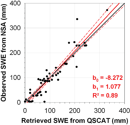
FIGURE 11.6 Comparison of snow-water equivalent (SWE) retrieved from QuikSCAT Ku-band data with a SWE radiative-transfer model function; SWE analyzed from NWS National Snow Analyses (NSA) observations in and near the scatterometer footprints throughout a single season at four sites in the Colorado Rocky Mountains. SOURCE: Courtesy of Don Cline, National Operational Hydrologic Remote Sensing Center.
Science Value
In the global water cycle, terrestrial snow is a dynamic freshwater reservoir that stores precipitation and delays runoff. Snow properties influence surface water and energy fluxes and other processes important for weather and climate, biogeochemical fluxes, and ecosystem dynamics. The SCLP mission will fill a critical gap in the current global water-cycle observing system. It will enable determination of the relevant spatial and temporal variations in the global distribution of cold-season precipitation, water storage, and surface fluxes. Snow covers up to 50 million km2 of the global land area seasonally (about 34 percent of the total land area) and affects atmospheric circulation and climate on local to regional and global scales. The SCLP mission will provide initial and boundary conditions for numerical weather prediction models. It will also provide quantitative information needed to help to understand the effects of snow on vegetation dynamics, soil moisture, soil freeze-thaw state, permafrost, and biogeochemical fluxes.
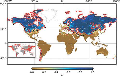
FIGURE 11.7 Accumulated annual snowfall divided by annual runoff over global and land regions. Red lines indicate regions where stream flow is snowmelt-dominated and where there is not adequate reservoir storage capacity to buffer shifts in seasonal hydrograph. Pink lines indicate additional areas where water availability is influenced predominantly by snowmelt generated upstream (but runoff generated within these areas is not snowmelt-dominated). Inset shows regions of globe that have complex topography according to the criterion of Adam et al. (2006). SOURCE: Reprinted from Barnett et al. (2005). Copyright 2005, by permission from Macmillan Publishers Ltd.
Societal Benefits
One sixth of the world’s population relies on water derived from seasonal snowpacks and glaciers (Barnett et al., 2005; see Figure 11.7). Freshwater derived from snow is often the principal source of water for drinking, food production, energy production, transportation, and recreation, especially in mountain regions and surrounding lowlands. That is true not only in high-latitude areas; snow is particularly important in many densely populated areas of North America, South America, Europe, the Middle East, and Asia. Climate warming seriously threatens the abundance of this freshwater resource and calls for immediate action to improve the understanding of climatic effects on water balance and hydrologic processes. Snow can also be hazardous—snowmelt has been responsible for some of the most damaging floods in the United States. The SCLP mission will also help to improve prediction of snowmelt-induced debris flows and periglacial dam breaches in mountain catchments.
Cost
Near the center of the range of cost options (about $300 million), the fundamental baseline mission concept is a dual-frequency, dual-polarization SAR combined with a dual-frequency radiometer at 19 and 37 GHz with H-polarization. Costs are reduced by using the same antenna for both the radar and the radiometer, maintaining a simple deployment strategy for the antenna and solar panels, and eliminating
scanning mechanisms needed for wide-swath systems. If the budget were increased to about $500 million, the instrumentation (dual high-frequency radar system and a radiometer) would remain essentially the same but would add global coverage with conical scanning (in the baseline configuration, there are gaps in coverage because of the relatively narrow swath, which conical scanning would expand).
Long-Term Observations
The SCLP mission will extend measurements of snow-covered area from optical instruments including the Advanced Very High Resolution Radiometer (AVHRR) and MODIS, as well as passive microwave radiometers such as SMMR, SSM/I, and AMSR-E, by increasing the spatial resolution over that of previous passive sensors. Since the passive microwave measurements from SCLP are at the same frequencies as those of the past and present space-borne radiometers, the SCLP measurements can contribute to a sustained record of over 25 years of passive microwave observations of snow properties. Furthermore, SCLP will enable establishment of more accurate relationships with long-term in situ snow observations (e.g., snow pillows or manual snow courses), owing to its higher spatial resolution.
Complementarity
The SCLP observations would complement high- to moderate-resolution observations of snow cover extent from optical sensors such as MODIS and VIIRS. Although the success of this mission does not depend on the existence of other missions, it would complement past, current and planned low-resolution snow observations from passive microwave sensors (AMSR-E and possibly a proposed microwave imager on NPOESS C-2, depending on specifics of the CMIS replacement) and scatterometry (the European Remote Sensing [ERS] satellite, the SeaWinds Scatterometer on QuikSCAT, and the Advanced Scatterometer [ASCAT] on MetOp).
Multidisciplinarity
The SCLP mission concept will contribute to advances in understanding climate variability and change; weather; land-use change, ecosystem dynamics, and biodiversity; and societal benefits of Earth science and applications in a number of ways. Changes in snow cover extent have key implications for the climate system because of the strong contrast in albedo between snow-covered and snow-free areas. If shorter time scales, snow cover extent globally is an important land-surface attribute for assimilation into weather prediction models. Ecosystem function in ephemerally snow-covered areas depends strongly on snow cover status and snowpack depth. Finally, as indicated above, snow-water storage is a critical variable over much of the Northern Hemisphere land areas for water supply; hence, the mission has important societal benefits.
Readiness
Because the proposed sensors have a substantial heritage, their technology readiness is high. The single shared pushbroom antenna will use low-cost, mature lightweight composite-reflector technology flown on the SSM/I, QuikSCAT, and WindSat missions. The radar and radiometer electronic technologies also have a high level of heritage from current and past space missions. As noted above, SCLP in its base configuration is identified as a Pathfinder-class mission; however, a larger budget would expand the coverage to global and would support operational uses of the data. A formal technology-assessment study is being performed
for instruments that are included in the ESA Explorer proposal—specifically, the radar (the ESA proposal does not include a passive radiometer).
Other High-Priority Water-Cycle Observations
Water Vapor Transport
Mission Summary—Water Vapor Transport
|
Variables: |
Water vapor profile; wind speed and direction |
|
Sensors: |
Passive microwave; GPS |
|
Orbit/coverage: |
LEO/global |
|
Panel synergies: |
Weather, Climate |
|
|
|
|
Related RFI responses: |
AIRS (8), WOWS (27), GPSRO (92) |
Water vapor transport is a major component of the global hydrologic budget. The freshwater flux (E-P) must ultimately be constrained by the divergence of water vapor over oceans and by the divergence of water vapor, surface storage (soil moisture, snow water equivalent), and runoff over land. Simultaneous measurement of those terms constitutes a strong constraint on each of the elements of the global hydrologic budget and is valuable to research efforts aimed at understanding fluxes in the global water budget. The transport of water vapor can be divided into two problems: the measurement of the vapor profile and the three-dimensional motions that transport the moisture. Measurement of vapor profiles can be accomplished with a number of combined infrared-microwave sounders, such as the current AIRS/AMSU instrument aboard EOS Aqua and the CrIS/ATMS instrument being planned for NPOESS. Advances in radio occultation measurements expected from the COSMIC constellation (Sokolovskiy et al., 2006) show great promise in adding valuable water vapor information in the atmospheric boundary layer. Together, those measurements and expected progress from research will form the basis for estimation of global three-dimensional water vapor fields. Still missing are the three-dimensional wind fields that transport the moisture. That is a highpriority observation for the Panel on Weather Science and Applications (Chapter 10), but it is important for the global water cycle as well.
The transport of water vapor constrains the hydrologic variables and lends insight into their mutual relationships. For example, a recent estimate of the water balance in South America (Liu et al., 2006) was made by combining measurements from the sensors listed in Table 11.1; the sum of precipitation, water vapor transport, and river discharge was shown to be consistent with an estimate of a seasonal change in the continent’s gravity (owing to changes in water storage). The Water and Ocean Wind Sensor (WOWS; RFI response 27) embodies many of those water-cycle objectives. It combines active and passive microwave concepts to provide coincident and improved measurements of many key oceanic, atmospheric, terrestrial, and cryospheric characteristics measured with a variety of separate current and planned space missions. By sharing a 6-m rotating parabolic deployable mesh antenna for active and passive microwave channels from 1.26 to 37 GHz, made feasible by recent advances in antenna technology, WOWS would enhance the spatial resolution of many measurements. This system would also provide the coincident measurements needed to optimize the retrieval of geophysical characteristics, and to characterize the multiscale and nonlinear interaction of the turbulent atmosphere and ocean.
The coincident measurements will provide comprehensive characterization of all the essential terms in hydrologic balance over oceans and the oceanic influence of the cryospheric and terrestrial hydrologic
cycles. It has strong potential for being part of and cost-sharing with the Global Change Observation Mission (GCOM)-W, which is actually a series of space missions planned by JAXA and is part of the constellation of GPM.
WOWS offers a strong complement of hydrologic observations over oceans, but its ranking as a water vapor transport mission was reduced by the panel somewhat because it lacks resolved vertical winds and therefore requires that transport itself over oceans be inferred indirectly and because transport cannot be inferred over land. That shortcoming is mitigated by its additional capabilities to measure ocean circulation, oceanic evaporation, and air-sea interaction and to map the cryosphere.
Sea Ice Thickness, Glacier Surface Elevation, and Glacier Velocity
Mission Summary—Sea Ice Thickness, Glacier Surface Elevation, and Glacier Velocity
|
Variables: |
Sea ice thickness, glacier surface elevation, glacier velocity |
|
Sensors: |
Lidar, InSAR |
|
Orbit/coverage: |
LEO/global |
|
Panel synergies: |
Climate, Solid Earth |
|
|
|
|
Related RFI responses: |
InSAR (83), ICESat++ (111) |
Glacier ice and sea ice are important components of the global water cycle and are highly sensitive to changes in climate. More than three-fourths of the freshwater on Earth is stored in the great ice sheets that cover most of Greenland and Antarctica and in glaciers. The dramatic decreases in extent and volume of glacier ice (see, for example, Figure 11.2) and sea ice are already having direct effects on society and will have more severe consequences if current warming trends continue.
Two concepts have the potential to provide important observational improvements of the global distribution of land and sea ice. A combined lidar (e.g., ICESat++) and InSAR mission such as that proposed by the climate, ecosystems, and solid-Earth panels would aid in monitoring changes in ice sheet elevation, sea ice freeboard, and glacier velocity. That concept is described in greater detail in Chapter 9.
Groundwater Storage, Ice Sheet Mass Balance, and Ocean Mass
Mission Summary—Groundwater Storage, Ice Sheet Mass Balance, and Ocean Mass
|
Variables: |
Groundwater storage, glacier mass balance, ocean mass distribution |
|
Sensor: |
Laser ranging |
|
Orbit/coverage: |
LEO/global |
|
Panel synergies: |
Climate, Solid Earth |
|
|
|
|
Related RFI responses: |
GRACE follow-on (GRACE-II) (42), ICESat++ (111) |
Water storage is an essential component of the hydrologic cycle and requires knowledge of the water mass stored in aquifers, soil, surface reservoirs, snowpack, ice sheets, and oceans. While GRACE, a NASA ESSP mission launched in 2002, has successfully demonstrated the feasibility of space-based gravity measurements for global land hydrology. Even though its relatively coarse spatial resolution (effectively about 500 km, although spatial resolution of GRACE has to be interpreted in a manner somewhat different from that of electromagnetic sensors) has limited its use to large regional-scale observations, breakthrough science has resulted, including observations of seasonal and multiyear variations in mass of the Antarctic and Greenland ice sheets. The only way to determine whether the multiyear trends are representative of
long-term changes in mass balance is to extend the length of the observations. Other hydrologic measures, such as mean river-basin evapotranspiration, may also be inferred for large river basins (Rodell et al., 2004), but are likewise constrained by the short data record. The somewhat improved spatial resolution of a proposed GRACE follow-on mission (GRACE-II) and the continuation of the observation record would provide invaluable observations of long-term climate-related changes in the mass of the Antarctic and Greenland ice sheets and large Arctic ice caps. Longer records that would allow better characterization of interannual changes in soil moisture and groundwater storage for use by hydrologists and for use in global land surface models would also result, although the coarse spatial resolution will continue to be a critical constraint.
Oceanography is another fertile field for microgravity measurements. Improved knowledge of absolute surface currents based on satellite altimetry is expected in the near future with precise measurements of the static geoid (e.g., with the European Gravity Field and Steady-State Ocean Circulation Explorer [GOCE] mission to be launched in 2008). Satellite altimetry cannot distinguish between sea-level changes from steric effects (temperature and salinity-induced) and those from water-mass effects. However, the separation is possible by combining altimetry with GRACE, which measures the ocean mass component only. Such a separation allows an independent estimate of glacier melt volume. However, the current GRACE mission has a low signal-to-noise ratio over the oceans. GRACE-II would provide more precise estimates of the vertically integrated ocean mass (or equivalent bottom pressure) variations associated with ocean currents. Assimilation of data from satellite altimetry and GRACE-II into general circulation models would allow determination of the vertical structure of the ocean circulation.
Sea-level rise is another potential application of microgravity measurements. Precise measurements of sea-level rise have been obtained with satellite altimetry for more than a decade. The main contributions to sea-level rise are thermal expansion due to ocean warming and water-mass input from continental reservoirs (glaciers, ice sheets, and land). GRACE-II would provide a basis for estimating the contribution of land water storage, including the anthropogenic contribution (effects of dams, irrigation, urbanization, deforestation, and so on), to the water budget of large river basins—measurements that are not now available from any source.
Inland and Coastal Water Quality
Mission Summary—Inland and Coastal Water Quality
|
Variables: |
Inland, coastal water quality; land-use, land-cover change |
|
Sensors: |
Hyperspectral imager, multispectral thermal sensor |
|
Orbit/coverage: |
LEO or GEO/global or regional |
|
Panel synergies: |
Climate, Ecosystems, Health |
|
|
|
|
Related RFI responses: |
FLORA (38), SAVII (97) |
Inland and coastal ecosystems convey many diverse and important benefits to society, including food, commercial navigation, waste processing, and recreation. But a growing body of evidence indicates that these systems are now experiencing major threats from the combined forces of upstream river management, overuse, and pollution (see, e.g., Figure 11.8). These changes are embedding a major human signature in the global biogeochemical cycles, including modification of thermal regimes, acceleration of nutrient flux, and interception of continental runoff and retention of suspended sediment otherwise destined for the world’s oceans. The world’s fisheries depend heavily on the high productivity of the estuaries and the coastal zones. For most of the globe, water-quality monitoring and assessment are highly fragmented. In the developed world, individual focused studies and routine monitoring provide some basis for evaluation
FIGURE 11.8 Rivers transport, process and deliver substantial quantities of constituents mobilized by erosion and dissolution of the continental land mass and pollutants attributable to human activities. The figure shows time series (September 1997-October 2000) of organic matter and sediment near the mouth of the Mississippi River (top panels: A, 1-2), and mean organic matter (lower left) and sediment (lower right) for that interval. SOURCE: Salisbury et al. (2001). Copyright 2001 American Geophysical Union. Reproduced by permission of American Geophysical Union.
of water-quality status and trends, but global-scale knowledge based on in situ observation has never been adequate and is in decline. Moreover, those fixed-point measurements do not characterize the interaction of spatial and temporal variability inherent in such complex, spatially distributed processes. A major opportunity presents itself for remote sensing to fill this strategic information gap.
Two mission concepts are designed to aid in monitoring the overall health of lakes, rivers, reservoirs, and coastal regions using indicators such as eutrophication from algal blooms, nuisance-plant growth, and increases in temperature. A hyperspectral sensor (e.g., FLORA) combined with a multispectral thermal sensor (e.g., SAVII) in low Earth orbit (LEO) is part of an integrated mission concept described in Parts I and II that is relevant to several panels, especially the climate variability panel. The hyperspectral sensor, with 30-m spatial resolution, would improve mapping capabilities for both algal blooms and sediments. Imaging spectrometry also provides the capability for integrated mapping of land and water properties. Land-use and land-cover changes can be monitored and used to infer nutrient leaching and sediment transport. The suggested 45-m spatial resolution of SAVII would be effective for high-resolution thermal monitoring of many coastal regions and inland water bodies but not smaller lakes and streams. The SAVII multispectral thermal imager would provide the capability for identifying thermal plumes associated with industrial point sources, seasonal runoff, and coastal upwelling, as well as longer-term changes in thermal regimes in lakes, rivers, and reservoirs.
A second mission concept would use a hyperspectral imager in geosynchronous orbit over North America as part of a coastal ecosystems mission concept and is described in greater detail in Chapter 7. That sensor would have variable spatial resolution (250–1,500 km) and subhourly observation timescales. The spectral range of 350–1,050 nm and spectral resolution of 1 nm would provide the capability to monitor rapid changes in water quality in coastal regions, such as the onset and dynamics of algal blooms and ocean surface eutrophication.
NEXT-GENERATION CHALLENGES
In the previous section, the panel ranked seven mission concepts that will make key contributions to water-cycle science. The missions were ranked primarily on the basis of their potential science contributions and societal relevance but also on the basis of other considerations, such as technical readiness. The panel identified several additional observation and estimation challenges that must be addressed but are not yet at the point that they can be recommended as specific mission concepts. Those challenges are described below.
Evaporation
Evaporation from land and ocean surfaces is poorly observed with in situ instruments, and its climatology is not well known. Evaporation also is not readily observable with remote sensing. Despite the observation issues, evaporation is central to Earth system science and its constitutive cycles (water, energy, and biogeochemical). Many aspects of climate and weather prediction depend on accurate determination of these fluxes, and current meteorological products are not advanced enough to provide accurate information. Development of the capability to monitor evaporation directly constitutes a grand challenge for Earth system science.
Despite the inability to measure evaporation directly with remote sensing, it is possible to measure states and processes that are needed to estimate evaporation. More accurate estimation will require a new perspective on how multisource measurements and models can be combined. The goal should be to facilitate estimation of the diurnal cycle of evaporation over land and ocean surfaces with errors (at temporal
resolutions sufficient to resolve the diurnal cycle) of less than 30 W m−2 at 10-km resolution and over the open ocean with an accuracy of 5 W m–2 at a spatial resolution of 1° (about 100 km). Those errors, although still substantial, would be small enough to be comparable with those in other terms in the global (and regional) water and energy budgets and so would facilitate direct estimation of evaporation errors rather than estimation as a residual term, as is often done (see Roads et al., 2003, for an example of water and energy budget estimation for the Mississippi River basin).
Under turbulent conditions, evaporation is directly proportional to latent heat flux (a component of the surface energy balance) and carbon flux in the surface carbon balance. Evaporation also codetermines—with precipitation—the rate of the global water cycle. The difference between evaporation and precipitation should be zero when globally aggregated, which gives a long-range performance goal for this grand challenge.
The difficulty in measuring evaporation from space is that bulk parameterizations, which are the primary means for estimating evaporation, require knowledge of the near-surface specific humidity, a measurement that continues to elude the scientific community. Even space-borne profilers with very high vertical resolution are unable to resolve the boundary layer with the needed precision. Other quantities necessary for estimation of the latent heat flux are surface wind speed and surface and near-surface temperatures. Over the oceans, surface wind estimates are possible with both active and passive microwave instruments with reasonable accuracy, although under high wind conditions only scatterometers have proven utility. Over land, direct measurement of surface wind from space is not now possible. Although not a direct input to the latent heat flux parameterization, surface temperature is needed to determine saturation vapor pressure at the surface in the case of ocean evaporation, and the actual surface humidity in the case of evaporation over land. Furthermore, the surface and air temperatures together determine the stability of the surface layer, which affects the transfer coefficients used in the calculation of latent heat flux.
Sea-surface and land temperature measurements with a variety of current and planned sensors in both the visible-infrared and microwave wavelengths can provide diurnally varying values with a relatively high level of accuracy, and a continued mix of space-borne microwave radiometers will continue this record. It should be noted that in addition to the satellite-data limitations there are still unresolved issues with the bulk flux parameterizations themselves (Curry et al., 2004).
Remote sensing of land radiometric surface temperature (LST) is critical for all current schemes to estimate evapotranspiration remotely. LST is directly related to the sensible heat component of the energy balance and is thus inversely proportional to latent energy and evaporation rates. The Bowen ratio (H/LE) summarizes the relationship between sensible and latent heat flux from a surface. Thermal remote sensing can provide an integrated look at land surface evaporation, although overpass timing is critical (midafternoon radiant heating of the land surface provides the most useful signal). For some purposes, data from the Geostationary Operational Environmental Satellites (GOES) also can be used to derive LST and surface evapotranspiration every hour under cloud-free conditions.
Other methods for inferring evaporation can, with a combination of measured and modeled techniques, give some understanding of this flux over large areas. For instance, atmospheric budget analysis using moisture convergence in combination with observed precipitation can be used to estimate evaporation by difference—a technique that is applicable over both land and ocean. Over the oceans, changes in upper-ocean salinity combined with oceanic advection can be used to produce an estimate of E—P (global time-varying salinity measurements from Aquarius are expected to improve the basis for estimating space-time fields of E—P over the oceans). In both cases, knowledge of precipitation is necessary—a constraint that is especially limiting over the oceans and portions of the land where precipitation is poorly observed. Other promising techniques involve the fusion of satellite data with global or regional climate-
model products. However, the use of those model products eliminates the possibility of comparing the resulting evaporation fields as independent data sources.
Given the inability to measure evaporation directly over large areas (with in situ or remote sensing methods), it is likely that the most important progress in this area will be in combination with improvements in assimilation into models that have improved boundary-layer physics. The panel believes that progress in this area should be a primary focus of the community over the next decade. Although it is not possible at present to define a satellite mission that would address the key science questions in this area, several planned satellite missions will have a central role and should be supported. They include VIIRS aboard NPOESS, which will provide functionality in estimating land and sea-surface temperature under clear skies and vegetation information over land, similar to what currently can be derived with the Terra and Aqua MODIS sensors. A high-resolution thermal infrared sensor equivalent to those previously flown on Landsat satellites would also be useful. Nonetheless, a more focused effort to address the complex problem of combining observations and modeling to produce consistent estimates of ocean and land evaporation is a pressing need, progress on which is essential before observation requirements can be fully specified.
Coordinated Observing Systems
The panel recognized that the current paradigm is for missions that focus on single primary measurements designed to address a primary science question, perhaps with so-called secondary science, but it also recognizes an alternative paradigm that attempts to address measurements of the water cycle in a more coordinated fashion—for example, by focusing on a broader set of issues and attempting to realize synergies associated with multiple, coordinated observations. Two such strategies are outlined here: one addresses coordinated measurement of global water-cycle variables, and the other is a cloud-aerosolprecipitation initiative.
Integrated Water-Cycle Observing System
Society’s welfare, progress, and sustainable economic growth—and life itself—depend on the abundance and vigorous cycling and replenishing of water throughout the global environment. The water cycle operates on a continuum of time and space scales and exchanges large amounts of energy as water undergoes phase changes and is moved from one part of the Earth system to another.
A central challenge of a future water-cycle observation strategy is to progress from single-variable water-cycle instruments to multivariable integrated water-cycle instruments, probably in electromagneticband families. Experience has shown that the microwave range in the electromagnetic spectrum is ideally suited for sensing the state and abundance of water because of water’s dielectric properties. Until now, limits on antenna technology have stymied the harvesting of the synergy that would be afforded by simultaneous multichannel active and passive microwave measurements. The removal of that roadblock is now possible.
A coordinated water-cycle observation strategy will require innovative technology in large microwave antennas that probably will come after the time frame of this decadal review. However, it is an essential element of the technology development needed to support advanced multivariate retrieval methods that can exploit the totality of the microwave spectral information and will facilitate next-generation watercycle observing systems. It is possible to see how existing technology and extensions thereof would support a multidisciplinary water-cycle measurement strategy—for example, through use of rotating-antenna technology.
A cross-disciplinary multichannel active and passive microwave concept would provide coincident and improved measurements of many key oceanic, atmospheric, terrestrial, and cryospheric dimensions. One possibility would be for active and passive microwave channels from 1.26 to 37 GHz to share a large (6-m) rotating parabolic deployable mesh antenna. That appears to be feasible as a result of recent advances in antenna technology and would have the effect of enhancing the spatial resolutions of many measures and providing the coincident measurements needed to optimize the retrieval of geophysical information. It would also allow characterization of the multiscale and nonlinear interaction of the turbulent atmosphere and ocean.
The mission would be a water-cycle and terrestrial-biomass observatory. The simultaneous multichannel active and passive microwave measurements would allow improved-accuracy retrievals of dimensions that were the focus of several Explorer-class mission concepts. To be concise, that means that the multiple instruments are not just sharing a spacecraft. Their simultaneous measurements lead to retrievals that are not possible with isolated measurements. Furthermore, the simultaneous monitoring of several of the land, atmospheric, oceanic, and cryospheric states brings synergies that will substantially enhance understanding of the global water cycle as a system.
A flagship mission based on that concept would combine the following measurements that in the present paradigm constitute individual missions (specific missions referred to elsewhere in this chapter are also indicated):
-
Precipitation measurement (GPM follow-on),
-
Ocean wind,
-
Soil moisture and land freeze-thaw mission (Hydros),
-
Cold-land processes Pathfinder (CLPP),
-
Biomass monitoring, and
-
Very-low-frequency subcanopy and subsurface observations (see, for example, discussion of the MOSS RFI response (70) in the section “Soil Moisture and Freeze-Thaw State”).
A shared-antenna subsystem would allow many of the requirements outlined in Table 11.2 to be met. It would accommodate the following measurements: scatterometry at P-, L-, C-, and Ku-bands and radiometry at L-, C-, and X-bands. The measurements would be simultaneous and would have the advantage of a common and steady look angle. The rotating antenna would facilitate a wide swath for 2- to 3-day repeat coverage.
Because the antenna subsystem would be shared, the instrument cost would not scale with the number of scatterometer and radiometer channels. Total mission cost would probably be around $700 million to $1 billion, which, although considerably larger than the cost for any of the individual component measurements, would represent a substantial savings relative to the sum of the costs for stand-alone missions for each of the elements. The cost is end-to-end with 30 percent reserves and for 5 years of operation. The instruments would share a single 6-m lightweight deployable mesh reflector capable of supporting multiple frequencies up to Ku-band. The sharing of elements of the antenna and digital subsystems results in substantial cost savings.
To reap the benefits of the synergy, some tradeoffs need to be made with respect to the constitutive Explorer-class mission. The principal one is to trade some spatial resolution loss for gains in revisit time and multichannel observations. That trade particularly affects biomass, snow, and deep-soil moisture (P-band). However, because carbon biomass, deep-soil moisture, and snowpack vary slowly, it may be possible to regain the resolution by combining multitemporal passes. On the other hand, the multichannel approach affords advantages to some constituent retrievals—for instance, simultaneous retrieval of vegetation biomass
TABLE 11.2 Elements of an Integrated Water-Cycle Observing System
|
Mission |
Science Objective |
Science Requirement |
|
SMAP-extended (includes P-band) |
|
|
|
Biomass monitoring |
|
|
|
SCLP |
|
|
|
Ocean-surface monitoring |
|
|
would improve soil-moisture retrieval by avoiding the need for auxiliary vegetation information. It should be noted that because altimetry, although based on radar, uses SAR rather than scatterometry, such a system would not monitor surface-water stage and surface area (hence volume) or river slopes. In addition, one shortcoming of shared-antenna systems is that an entire system is susceptible to complications in any of the individual instruments; that is, the cost savings are achieved by accepting the risk of multi-instrument “slippage,” as has been the case with NPOESS.
Cloud-Aerosol-Precipitation Initiative
One of the key uncertainties in weather, climate, and freshwater supply remains the processes that govern the interaction among aerosols, clouds, and precipitation (see Figure 11.9). The need to understand those processes better has been articulated by a number of studies, including the Intergovernmental Panel on Climate Change report Climate Change 2001: The Scientific Basis (IPCC, 2001), the Strategic Plan for the U.S. Integrated Earth Observation System (IWGEO, 2005), and Our Changing Planet: U.S. Climate Change Science Program for Fiscal Year 2006 (CCSP, 2005). Because aerosols serve as nuclei for cloud
FIGURE 11.9 Saharan dust storm of July 24, 2003, showing dust cloud over the Atlantic Ocean and Canary Islands off north-west Africa, as captured by NASA’s MODIS instrument on the Terra satellite. Earlier, USSR cosmonaut Vladimir Kovalyonok had observed, “As an orange cloud formed as a result of a dust storm over the Sahara and, caught up by air currents, reached the Philippines and settled there with rain, I understood that we are all sailing in the same boat.” SOURCE: Image courtesy of NASA.
particles and affect their growth to precipitation-size particles—as well as influencing the opacity of clouds to sunlight—the close interaction among these processes is evident.
The main objective of an integrated cloud-aerosol-precipitation mission would be to provide a more quantitative basis for predicting changes in the planet’s hydrologic cycle and energy balance as a step toward prediction of severe weather, climate, and climate change with much higher confidence than now exists. The cloud-aerosol-precipitation climate problem is complex and progress will probably require a
coordinated combination of observation and theoretical techniques, platforms and vantage points, and strategies that explicitly plan for integration of the components. The rewards, however, are also extremely high and could include advances in issues of air pollution and human health, availability of freshwater, prediction of weather and extreme events, aerosol effects on climate, and cloud influences on climate.
Portions of the space-based component of a coordinated observation plan along those lines were articulated in various RFI responses dealing with cloud-aerosol, aerosol-precipitation, and cloud-aerosol-precipitation relationships. This mission concept and package might involve the addition of instruments to approved missions (e.g., GPM and NPOESS). Additional assets, such as a new high-spectral-resolution lidar for aerosol detection and analysis combined with multifrequency Doppler radar for cloud content and vertical motions, are required. Tropospheric wind observations would also be needed to help to separate the effects of atmospheric motions from the effects of aerosol concentrations. That will be addressed in part by the Aerosol-Cloud-Ecosystem (ACE) mission concept (Parts I and II) but is referred to here as an initiative because the complexity of the problem requires careful coordination of the ACE mission with other proposed missions, such as Wind Lidar (3D-Winds in Parts I in II) and potential international contributions (e.g., EarthCARE and potential follow-ons).
A coordinated cloud-aerosol-precipitation initiative requires close coordination among the weather, climate, and water communities. International cooperation, specifically with Japanese and European scientists and agencies, would be needed to bring such an initiative to fruition. A working group to plan and coordinate the addition of targeted observations to future missions should be established immediately to bring this grand challenge in Earth sciences to bear in the 2015–2025 time frame. The initiative—which would involve multifrequency Doppler radars, high-spectral-resolution lidars, wind lidars, and radiometers—would be expensive. It should not be envisioned as a stand-alone mission, but rather as an initiative that would enable systematic planning among national and international agencies to bring the measurement concept to fruition. By systematic leveraging of assets approved for other missions, the cloud-aerosol-precipitation initiative would focus mostly on optimizing (and coordinating) planned missions rather than on new launches. The complexity of the problem, and the great wealth of potential assets in the form of planned missions globally, require that this effort be undertaken by a body more formal than an ad hoc group of interested scientists.
End-to-End Information-System Needs
Managing the next generation of satellite data will be more challenging, and user requirements much greater, than today. Global water-cycle information must be synthesized from a wide variety of sensors—optical, thermal, passive and active microwave, polar orbiting, geostationary, and so on. Some of the data must be delivered in real time, especially for weather forecasting and flood warnings. Other data must be archived stably to allow retrieval for analysis of climate trends over many decades. Additionally, critical in situ information—such as stream flow, snowpack, and lake and reservoir stage data—must be integrated with the satellite data for optimal interpretation and policy analysis.
Scientifically, it is most valuable to have water-cycle data harmonized and accessible from one (possibly virtual) location and at multiple time and space resolutions. For instance, one cannot understand or forecast runoff trends, including floods, without first knowing about precipitation. Lead responsibility for observing various aspects of the water cycle crosses NASA, NOAA, USGS, and USDA. Building and sustaining integrated hydrologic data sets for the United States will require coordination among those agencies that, although technologically feasible, does not yet exist—notwithstanding efforts such as those of the Corporation of Universities for the Advancement of Hydrologic Sciences Hydrologic Information System “WaterOneFlow” Web services enterprise.
NASA may have responsibility only for delivering the satellite-based data stream, but the agencies named above collectively have responsibility for building the coordinated data system that an integrated hydrologic forecast model requires. Furthermore, although some of the measurements needed to understand and predict water-cycle changes are included in the observation systems that support global weather forecasts (e.g., NPOESS), the measurements that have demonstrated potential for research and applications will need to be sustained (see the section “Prioritized Observation Needs”) to monitor trends and to allow the development of prediction schemes. One or more of the above agencies will need to be responsible for sustaining the observations beyond the individual proposed missions.
Global hydrologic information presents an even greater challenge, particularly because in situ data sets are the property of individual nations and are generally less openly available than is the case in the United States (IAHS, 2001). Because water is an economic commodity, cross-border water jurisdiction issues require international data sets. Satellite data represent the only unbiased repeatable measurements available from some countries and so are exceptionally valuable for global hydrologic studies. Given that U.S. scientists must rely more on foreign satellites for data, sharing global data sets will be essential for scientific progress.
SUMMARY
Water is central to life on Earth, but there are substantial gaps in understanding of the location of stored water and the processes that control its movement. Better understanding of the water cycle not only would have important science benefits but also would benefit society by facilitating more effective management of this renewable resource. That better understanding will require new and more comprehensive measurements, which are feasible only through a combination of remote sensing and in situ observations. The imperative for future water-cycle missions is the ability to address both scientific and societal challenges. The scientific challenge is to integrate in situ and space-based observations to quantify the key water-cycle state variables and fluxes. The centerpiece of this vision will be a series of Earth observation missions that will measure the states, stocks, flows, and residence times of water on regional to global scales, followed by a series of coordinated missions that will address the processes, on a global scale, that underlie changes in the state parameters. The accompanying societal challenge is to make better use of water data produced by in situ and remote-sensing missions to manage water resources more effectively.
The four highest-ranked water-cycle missions proposed in this chapter would contribute greatly to the science and societal goals associated with water. The approved GPM mission is recommended for launch without further delay. It will provide diurnal estimates of precipitation at a spatial resolution sufficient to resolve major spatial variations over land and sea. A soil moisture mission (Soil Moisture Active/Passive, or SMAP in Parts I and II) would provide estimates of soil moisture over most of the globe. Soil moisture is a key term in the land surface water balance that controls land-atmosphere fluxes over many parts of the globe (in particular, recycling of moisture from land to atmosphere); it is a key variable that affects the response of runoff to precipitation and hence is critical for flood and drought prediction. A surface water mission (a generalization of which is SWOT, Surface Water and Ocean Topography, in Parts I and II) would provide observations of the variability of water stored in lakes, reservoirs, wetlands, and river channels and would support estimates of river discharge. It would also provide information necessary for water management, particularly in international rivers. And a snow and cold lands mission would estimate the water storage of snowpacks, especially in spatially heterogeneous mountainous regions that are the source areas for many of the world’s most important rivers.
Taken together and in coordination with in situ and airborne sensors, these four missions would form the basis of a coordinated effort to observe the terrestrial surface water cycle globally. However, building
and sustaining integrated hydrologic data sets for the United States will require close coordination among many federal agencies and a commitment to sustaining the observations beyond the individual proposed missions.
In addition to the four missions, several that would benefit analyses of the water cycle were highly rated by the water resources panel, albeit less highly than the four identified above. They include missions that would estimate water vapor transport, sea ice thickness and glacier mass balance, groundwater storage and ocean mass, and inland and coastal water quality (see Table 11.1). Those measurements and watercycle issues are discussed in the section “Other High-Priority Water-Cycle Observations” above. Some of the measurements have direct relevance to the needs of other panels, and that synergy was considered in the selection of the integrated missions recommended in Parts I and II.
The panel identified several next-generation observation and estimation challenges that must be addressed but need additional time for technology development. They included development of the capability to monitor evaporation directly from space and creation of coordinated observing systems. Two examples of the latter might be a cloud-aerosol-precipitation initiative and a global water-cycle system to “simultaneously” measure precipitation, ocean wind, soil moisture and land freeze-thaw, snow-water equivalent, biomass, and the subsurface.
BIBLIOGRAPHY
Adam, J.C., E.A.Clark, D.P.Lettenmaier, and E.F.Wood, 2006. Correction of global precipitation products for orographic effects. J. Climate 19(1):15–38.
Alsdorf, D.E., and D.P.Lettenmaier. 2003. Tracking fresh water from space. Science 301(12):1491-1494.
Alsdorf, D.E., E.Rodriguez, and D.P.Lettenmaier. 2007. Measuring surface water from space. Rev. Geophys. 45:RG2002, doi:10.1029/ 2006RG000197.
Barnett, T.P., J.C.Adam, and D.P.Lettenmaier. 2005. Potential impacts of a warming climate on water availability in snow-dominated regions. Nature 438:303–309, doi:10.1038/nature04141.
Barry, J.M. 1997. Rising Tide: The Great Mississippi flood of 1927 and How It Changed America. Simon and Schuster, New York.
Cahill, A., M.Parlange, T.Jackson, P.O’Neill, and T.Schmugge, 1999. Evaporation from non-vegetated surfaces: Surface aridity methods and passive microwave remote sensing. J. Appl. Meteorol. 38:1346–1351.
CCSP (Climate Change Science Program). 2005. Our Changing Planet: The U.S. Climate Change Science Program for Fiscal Year 2006. CCSP, Washington, D.C.
Chen, F., T.T.Warner, and K.Manning. 2001. Sensitivity of orographic moist convection to landscape variability: A study of the Buffalo Creek, Colorado, flash flood case of 1996. J. Atmos. Sci. 58(21):3204–3223, doi:10.11 75/1520–0469(2001)058.
Curry, J.A., A.Bentamy, M.A.Bourassa, D.Bourras, E.F.Bradley, M.Brunke, S.Castro, S.H.Chou, C.A.Clayson, W.J.Emery, L. Eymard, C.W.Fairall, M.Kubota, B.Lin, W.Perrie, R.R.Reeder, I.A.Renfrew, W.B.Rossow, J.Schulz, S.R.Smith, P.J.Webster, G.A.Wick, and X.Zeng. 2004. SEAFLUX. Bull. Am. Meteorol. Soc. 85:409–424.
du Plessis, L.A. 2002. A review of effective flood forecasting, warning and response system for application in South Africa. Water SA 28:129–137.
Entekhabi, D., E.Njoku, P.Houser, M.Spencer, T.Doiron, J.Smith, R.Girard, S.Belair, W.Crow, T.Jackson, Y.Kerr, J.Kimball, R.Koster, K.McDonald, P.O’Neill, T.Pultz, S.Running, J.C.Shi, E.Wood, and J.van Zyl. 2004. The Hydrosphere State (HYDROS) mission concept: An Earth system pathfinder for global mapping of soil moisture and land freeze/thaw. IEEE Trans. Geosci. Remote Sens. 42(10):2184–2195.
Fu, L-L., and A.Cazenave, eds. 2001. Satellite Altimetry and Earth Sciences: A Handbook of Techniques and Applications. International Geophysics Series Vol. 69. Academic Press, New York.
Goni, G., and J.Trinanes. 2003. Ocean thermal structure monitoring could aid in the intensity forecast of tropical cyclones. EOS 84:573–580.
Hong, S.-Y., and E.Kalnay. 2000. Role of sea surface temperature and soil-moisture feedback in the 1998 Oklahoma-Texas drought. Nature 408:842–844.
Hossain, F., and N.Katiyar. 2006. Improving flood forecasting in international river basins EOS 87(5):49–50.
Huang, J., H.M.van den Dool, and K.P.Georgakakos. 1996. Analysis of model-calculated soil moisture over the United States (1931– 1993) and applications to long-range temperature forecasts. J. Climate 9:1350–1362.
IAHS (International Association of Hydrological Sciences). 2001. Global water data: A newly endangered species. EOS 82(5):54, 56, 58.
IMF (International Monetary Fund). 2002. The World Economic Outlook (WEO) Database. IMF, Washington, D.C.
IPCC (Intergovernmental Panel on Climate Change). 2001. Climate Change 2001: The scientific basis. Contribution of Working Group 1 to the Third Assessment Report of IPCC. Cambridge University Press, Cambridge, U.K.
IWGEO (Interagency Working Group on Earth Observations). 2005. Strategic Plan for the U.S. Integrated Earth Observation System. National Science and Technology Council, Washington, D.C.
Kabat, P., and H.van Schaik. 2003. Climate Changes the Water Rules: How Water Managers Can Cope with Today’s Climate Variability and Tomorrow’s Climate Change. Delft, The Netherlands. Available at http://www.waterandclimate.org.
Lettenmaier, D.P., A.De Roo, and R.Lawford. 2006. Towards a capability for global flood forecasting. WMO Bull. 55:185–190.
Liu, W.T., X.Xie, W.Tang, and V.Zlotnicki. 2006. Spacebased observations of oceanic influence on the annual variation of South American water balance. Geophys. Res. Lett. 33LL08710, doi:10.1029/2006GL025683.
Mitchell, K.E., D.Lohmann, P.R.Houser, E.F.Wood, et al. 2004. The multi-institution North American Land Data Assimilation System (NLDAS): Utilizing multiple GCIP products and partners in a continental distributed hydrological modeling system. J. Geophys. Res. 109:D07S90, doi:10.1029/2003JD003823.
Mote, P.W., A.F.Hamlet, M.P.Clark, and D.P.Lettenmaier. 2005. Declining mountain snowpack in western North America. Bull. Am. Meteorol. Soc. 86:39–49.
Myneni, R.B., J.Dong, C.J.Tucker, R.K.Kaufmann, P.E.Kauppi, J.Liski, L.Zhou, V.Alexeyev, and M.K.Hughes. 2001. A large carbon sink in the woody biomass of Northern forests. Proc. Natl. Acad. Sci. U.S.A. 98:14784–14789.
Nemani, R.R., C.D.Keeling, H.Hashimoto, W.M.Jolly, S.C.Piper, C.J.Tucker, R.B.Myneni, and S.W.Running. 2003. Climate-driven increases in global terrestrial net primary production from 1982 to 1999. Science 300:1560–1563.
NRC (National Research Council). 1991. Opportunities in the Hydrologic Sciences. National Academy Press, Washington, D.C.
NRC. 1999. Appendix C in “Assessment of NASA’s Plans for Post-2002 Earth Observing Missions,” letter from SSB chair Claude R. Canizares, Task Group chair Marvin A. Geller, Board on Atmospheric Sciences and Climate co-chairs Eric J.Barron and James R. Mahoney, and Board on Sustainable Development chair Edward A.Frieman to Ghassem Asrar, NASA’s associate administrator for Earth Science, April 8.
NRC. 2005. Earth Sciences and Applications from Space: Urgent Needs and Opportunities to Serve the Nation. The National Academies Press, Washington, D.C.
Pielke, R.A., Jr. 2005. Attribution of disaster losses. Science 310:1615–1616.
Pielke, R.A., Jr., M.W.Downton, and J.Z.Barnard Miller. 2002. Flood Damage in the United States, 1926–2000: A Reanalysis of National Weather Service Estimates. University Corporation for Atmospheric Research, Boulder, Colo.
Roads, J., R.Lawford, E.Bainto, E.Berbery, S.Chen, B.Fekete, K.Gallo, A.Grundstein, W.Higgins, M.Kanamitsu, W.Krajewski, V.Lakshmi, D.Leathers, D.Lettenmaier, L.Luo, E.Maurer, T.Meyers, D.Miller, K.Mitchell, T.Mote, R.Pinker, T.Reichler, D.Robinson, A.Robock, J.Smith, G.Srinivasan, K.Verdin, K.Vinnikov, T.Haar, C.Vorosmarty, S.Williams, and E.Yarosh. 2003. GCIP water and energy budget synthesis (WEBS). J. Geophys. Res. 108(D16):8609.
Rodell, M., J.S.Famiglietti, J.L.Chen, S.I.Seneviratne, P.Viterbo, S.Holl, and C.R.Wilson. 2004. Basin scale estimates of evapotranspiration using GRACE and other observations. Geophys. Res. Lett. 31:L20504, doi:10.1029/2004GL020873.
Salisbury, J.E., J.W.Campbell, L.D.Meeker, and C.Voorsmarty. 2001. Ocean color and river data reveal fluvial influence in coastal waters. EOS 82:221–227.
Smith, E.A., G.Asrar, Y.Furuhama, A.Ginati, C.Kummerow, V.Levizzani, A.Mignai, K.Nakamura, R.Adler, V.Casse, M.Cleave, M.Desbois, J.Durning, J.Entin, P.Houser, T.Iguchi, R.Kakar, J.Kaye, M.Kojima, D.Lettenmaier, M.Luther, A.Metha, P. Morel, T.Nakazawa, S.Neeck, K.Okamoto, R.Oki, G.Raju, M.Shepherd, E.Stocker, J.Testud, and E.Wood. 2006. International Global Precipitation Measurement (GPM) Program and Mission: An Overview. In Measuring Precipitation from Space: EURAINSAT and the Future (V.Levizzani and F.J.Turk, eds.). Kluwer Publishers, Dordrecht, The Netherlands.
Sokolovskiy, S., Y.-H.Kuo, C.Rocken, W.S.Schreiner, D.Hunt, and R.A.Anthes. 2006. Monitoring the atmospheric boundary layer by GPS radio occultation signals recorded in the open-loop mode. Geophys. Res. Lett. 33, doi:10.1029/2006GL025955.
UNDP (United Nations Development Program). 2004. Guidelines for Reducing Flood Losses. United Nations, Geneva.
Vigerstol, K. 2002. Drought planning in Mexico’s Rio Bravo basin, MS Thesis, Department of Civil and Environmental Engineering, University of Washington.
Webster, P.J., T.Hopson, C.Hoyos, A.Subbiah, H.-R.Chang, and R.Grossman. 2006. A three-tier overlapping prediction scheme: Tools for strategic and tactical decisions in the developing world. Pp. 645–673 in Predictability of Weather and Climate (T. Palmer and R.Hagedorn, eds.). Cambridge University Press, Cambridge, U.K.
ATTACHMENT
Table 11.A.1 lists 47 responses to the decadal survey committee’s RFI (see Appendixes D and E) that were considered by the Panel on Water Resources and the Global Hydrologic Cycle for possible relevance to the water cycle. The panel’s use of the RFI responses is discussed in the section “Prioritized Observation Needs” earlier in this chapter.
TABLE 11.A.1 Water-Cycle-Relevant RFI Responses Examined by the Panel
|
RFI Response Number |
Response Title |
Comment |
|
2 |
SIRICE |
Submillimeter Infrared Radiometer Ice Cloud Experiment (SIRICE): Daily Global Measurements of Upper Tropospheric Ice Water Path and Ice Crystal Size |
|
5 |
ATOMMS |
Active Temperature, Ozone, and Moisture Microwave Spectrometer: Constellation of small satellites to provide high vertical resolution moisture,ozone,temperature and pressure measurements in troposphere and middle atmosphere |
|
9 |
ARIES |
Atmospheric Remote-Sensing and Imaging Emission Spectrometer: Observe the infrared spectrum from 3.6 to 15.4 µm at high spatial resolution ≥ 1×1 km globally; both of these features are critical for the study of the hydrology cycle and for understanding the water vapor feedback |
|
13 |
CHARMS |
Cloud Height and Altitude-Resolved Motion Stereo-imager |
|
14 |
CHASM |
Cloud Hydrology and Albedo Synthesis Mission: Mission to measure the water content of clouds, concurrently with their albedo and cloud-top height |
|
17 |
Climate Scope Reanalysis Mission Concept |
A mission to produce, validate, and disseminate physically consistent climate research quality data sets from separate missions and satellite platforms |
|
19 |
CLPP |
Cold Land Processes Pathfinder: Advanced Space-based Observation of Fresh Water Stored in Snow |
|
21 |
COCOA |
Coastal Ocean Carbon Observations and Applications: Integrated observations (hyperspectal from GEO) and models to discriminate and quantify particulate and dissolved carbon species in coastal waters, as well as the exchanges of carbon between the land, atmosphere, and ocean |
|
23 |
C-CAN |
Continuous Coastal Awareness Network will measure sea surface height,coastal currents and winds and sea spectral reflectance from different Earth vantage points at high spatial and/or temporal resolution |
|
25 |
Daedalus |
Daedalus: Earth-Sun Observations from L1: Simultaneously observe key solar emission/space weather parameters and spectrally resolved radiances over the entire illuminated Earth to characterize the direct influence of solar variability on the Earth system |
|
27 |
WOWS |
Water and Ocean Wind Sensor using active and passive microwave concepts |
|
36 |
Emory CU Surge |
GPS to measure ocean wind speed/direction, sea surface height and land surface soil moisture |
|
38 |
FLORA |
Global, high spatial resolution measurements of vegetation composition, ecosystem processes and productivity controls, and their integrated responses to climate |
|
42 |
Grace Follow-on Mission |
GRACE follow-on |
|
44 |
GISMO |
Glaciers and Ice Sheets Mapping Orbiter |
|
46 |
Global Water Resources Mission |
An international effort consisting of about two dozen satellite systems, each of which is comparable with current operational GEO and LEO satellites |
|
49 |
GPS-HOT |
High resolution/high temporal revisit oceanography mission for mesoscale process characterization, will also yield data suitable for global tsunami warning |
|
50 |
H2S Ocean Emissions |
H2S emitting from ocean surface |
|
55 |
Human-Induced Land Degradation |
Detecting Human Induced Land Degradation Impact on Semi-Arid Tropical Rainfall Variability. Uses satellite-derived precipitation data, satellite-derived vegetation index data (no apparent observation program proposed) |
|
56 |
Hydros |
Hydrosphere Mapper: Radar interferometry system to make high-resolution measurement of the surface of the ocean and water bodies on land |
|
61 |
CAMEO |
Composition of the Atmosphere from Mid-Earth Orbit |
|
RFI Response Number |
Response Title |
Comment |
|
62 |
OOLM |
Operational Ocean and Land Mission: Wide swath ocean altimeter, and dual frequency (C- or X-band and L-band) SAR, plus Visible/Infrared Imaging Spectrometer on two satellites,for various (primarily ocean/coastal) needs |
|
66 |
CLAIM 3-D Mission |
Satellite mission to advance understanding of cloud and precipitation development by measuring vertically resolved cloud microphysical parameters in combination with state of the art aerosol measurements |
|
67 |
MATH |
Monitoring Atmosphere Turbulence and Humidity |
|
70 |
MOSS |
The Microwave Observatory of Subcanopy and Subsurface is a synthetic aperture radar (SAR) operating at the two low frequencies of 137 MHz (VHF) and 435 MHz (UHF) with the primary objective of providing measurements for estimation of global soil moisture under substantial vegetation canopies (200 tons/ha or more of biomass) and at useful soil depths (2–5 meters) |
|
71 |
GEOCarb Explorer |
GEOCarb mission will provide continent-wide measurements of ecosystem carbon and water dynamics with multiple observations per day |
|
72 |
Multiplatform InSAR |
Forest Subcanopy Topography and Soil Moisture |
|
74 |
Suborbital Earth System Surveillance |
UAVs to be used for synoptic weather, hurricanes, air quality, stratospheric ozone, ozone depleting substances, greenhouse gases, ice sheets, forest fires, droughts, and storm damage |
|
76 |
Far IR |
Far-Infrared for understanding natural greenhouse effect, atmospheric cooling by water vapor, and the role of cirrus clouds in climate |
|
79 |
Integrated Water Cycle Observations |
Coordinated water cycle observations from space |
|
80 |
Low-Cost Multispectral Earth Observing System |
Global land observation system that enhances Landsat and OLI with stereo multispectral imaging, greater coverage, revisit (eight days and better), and higher resolution |
|
82 |
Surface Uncertainty |
Surface Shortwave and Longwave Broadband Network Observation Uncertainty for Climate Change Research |
|
83 |
InSAR |
InSAR from orbital platform, in particular to produce spatially continuous maps of ground displacements at fine spatial resolution, for natural hazards science and applications |
|
86 |
OCEaNS |
Ocean Carbon, Ecosystem and Near-Shore Mission designed to advance quantification of ocean primary production, understanding of carbon cycling,and capacity for predicting ecosystem responses to climate variability |
|
87 |
OLOM |
Ocean and Land Operational Mission: Similar to OOLM except that second satellite would carry a 2 frequency Delay-Doppler Altimeter and a Water Vapor Radiometer rather than WSOA |
|
88 |
Our Vital Skies |
Program to address scientific questions at the interface between aerosol, cloud and precipitation research using combination of in situ and space-based observations |
|
90 |
Polar |
Polar Environmental Monitoring, Communications, and Space Weather from Pole Sitter Orbit |
|
91 |
ABYSS |
Radar altimeter for bathymetry, geodesy, oceanography |
|
92 |
GPSRO |
Contributions of Radio Occultation Observations to the Integrated Earth Observation System |
|
97 |
SAVII |
Spaceborne Advanced Visible Infrared Imager Concept: Hyperspectral measurements in vis-near IR; multispectral measurements in short wave infrared, and multispectral measurements in thermal infrared for vegetation studies, changes in surface cover and composition,and thermal monitoring |
|
RFI Response Number |
Response Title |
Comment |
|
|
|
|
|
99 |
SH2OUT |
Sensing of H2O in the Upper Troposphere |
|
100 |
GPM |
Global Precipitation Mission |
|
103 |
Surface Observatories in Support of Observations of Aerosols and Clouds |
Surface observations of water vapor, temperature, and winds, plus surface radiative fluxes and cloud and aerosol properties |
|
104 |
Terra-Luna |
Earth-Moon science mission that would provide Earth measurements over a relatively short period during Earth-orbiting phase, revisited at intervals of a decade or so, including boreal and tropical forest land cover and biomass mapping, global ocean eddies, coastal currents and tides, and land cover and canopy height |
|
107 |
Water Vapor Monitoring Missions |
|
|
108 |
WatER |
The Water Elevation Recovery Satellite Mission |
|
110 |
Climate-Quality Observations from Satellite Lidar |
Lidar measurements to address the themes of climate variability and change, weather, and water resources and the global hydrologic cycle |
|
111 |
Advanced ICESat |
Ice Cloud and land Elevation Satellite |
|
NOTE: A complete list of RFI responses is provided in Appendix E. Full-text versions of the responses are included on the compact disk that contains this report. |
||


