APPENDIX D
A Visual Impact Assessment Process for Evaluating Wind-Energy Projects
Evaluating aesthetic impacts requires a process of information-gathering, analysis, and evaluation. This appendix provides a more detailed outline than is in Chapter 4 of the steps involved and some of the underlying visual principles that form the basis of aesthetic impact assessment.
The steps are as follows:
-
Project Description.
-
Project Visibility, Appearance, and Landscape Context.
-
Scenic-Resource Values and Sensitivity Levels.
-
Assessment of Aesthetic Impacts.
-
Mitigation Techniques.
-
Determination of Acceptability or Undue Aesthetic Impacts.
PROJECT DESCRIPTION
A detailed description of all elements of a proposed project is an essential first step. All site alternatives that will have potential visual impacts should be identified by the developer in detail. These should include the characteristics of the turbines (e.g., height, rotor diameter, color, rated noise levels), the number planned, their locations; information about meteorological towers; roads; collector, distribution, and transmission lines; temporary or permanent storage (“laydown”) areas; substations; and any structures associated with the project. In addition all site clearing should be identified, including clearing for turbines, roads, power lines, substations, and laydown areas. Information also is needed on all site regrading that will
be engineered, including the amount of cut and fill, locations, and clearing required. This information forms the basis for all aesthetic review.
PROJECT VISIBILITY AND LANDSCAPE CONTEXT
A number of tools and techniques are available for determining visibility and for describing relevant landscape and project characteristics. The key techniques outlined below often are required as part of a permit application.
Computer Viewshed Analysis
Computer-generated maps based on digital-elevation models (DEMs) illustrate where any hypothetical point (such as the tip of a turbine blade) could potentially be visible within a given area, such as a 10-mile radius around the proposed project (Figure D-1). They also can indicate approximately how many turbines are likely to be visible from a given point. They are based on digital-terrain modeling and may not account for surface elements like vegetation or buildings that might block views. Field analysis is essential to verify actual visibility. It also is possible to do a “partial viewshed analysis,” which examines the visibility of particular turbines, or to look at a particularly sensitive viewing point on the ground to examine an area of potential visibility.
Line-of-Sight Visual Analysis
When complex topography makes it difficult to determine whether a particular turbine or other object will be visible from a particular point, a line-of-sight analysis can provide a useful check (Figure D-2).
Simulations (Visualizations)
Several types of simulations can be used to help predict how the project will appear. Photographic simulations or photomontages based on still photographs taken from selected viewpoints are the most common (Figures D-3 and D-4). Some professionals prefer 3D visualization models, which create a digital image from selected viewpoints. These images eliminate the variability and lack of clarity in some photographs and can depict conditions ranging from clear blue skies to nighttime lighting conditions, but they are not as realistic in appearance and details as a photographic simulation. Animated simulations illustrate the rotation of the blades on the turbines at accurate speeds. Photographic simulations generally show only a narrow window of a particular view (wide-angle lenses result in inaccurate perspec-
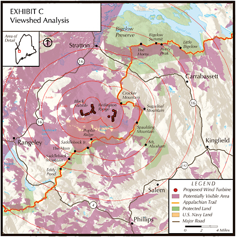
FIGURE D-1 Example of a simple viewshed analysis map showing areas from which a proposed wind-energy project would potentially be visible (shaded areas). Field assessment is necessary to determine actual visibility and the characteristics of the views. Source: Appalachian Trail Conservancy 2007. Reprinted with permission; copyright 2007, Appalachian Trail Conservancy.
tives). In understanding visual impacts it is useful to understand the broader context of the view. Whether the broader panorama will contain turbines as well, or whether it will remain undeveloped, will be an equally important part of the analysis. Several 3D visualization programs allow “fly-through” simulations, and are based on a virtual landscape.
Creating technically accurate simulations is critically important. Simulations can be manipulated to produce images that either exaggerate or minimize the visual impacts of a proposed project. Accuracy should be
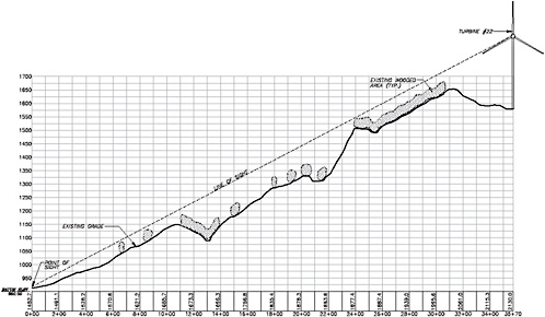
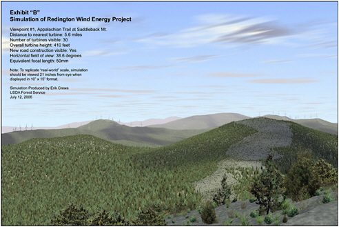
FIGURE D-3 Example of a “virtual” simulation using 3-D Nature Studio software. Whether they are based on photographs or created entirely from a Digital Terrain Model and 3-D software, the image must rely on accurate terrain modeling and GPS (Global Positioning System) point recording, and on an image that represents the equivalent of a 50-mm lens or a field of view of 38.6 degrees.
SOURCE: Erik Crews, Department of Agriculture, National Forest Service.
checked by experts in the field of digital images. Another check is to have at least two independent parties provide simulations from the same point. The following description provides an overview of good practice, but consulting technical experts and developing standards will be important.
Photographs should be taken with a 50-mm lens or digital equivalent that creates a 38.6° angle of view, which most closely matches human visual perception. Shorter focal lengths tend to flatten out topography and the vertical impression of the turbines, while longer focal lengths tend to exaggerate these features. However, the human eye is much sharper than any camera lens, and so photographs should be taken at high resolution, whether a film or a digital camera is used. Clear weather provides the best clarity of the scene as well as “worst-case conditions,” which should be represented in all simulations to allow a complete evaluation. Foreground clutter such as power poles should be avoided if possible in the photograph. Global-positioning system (GPS) location points should be recorded for each simulation viewpoint, preferably using a GPS unit with submeter ac-
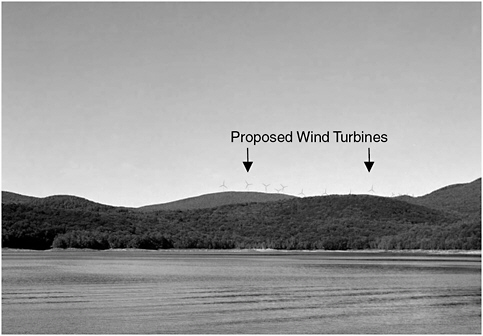
FIGURE D-4 Photographic simulation (photomontage) showing proposed 1.5 MW turbines with existing 0.55 MW turbines (right), Wilmington, Vermont.
SOURCE: Photograph by Jean Vissering, Jean Vissering Landscape Architecture; Simulation by AWS-Truewind for Vermont Environmental Research Associates.
curacy, but at least 3 m accuracy, to ensure repeatability. Some landscape architects fly weather balloons to mark locations of the nacelle in the field, but on windy sites it may be difficult to get a vertical position.
Using a DEM, various 3D programs create accurate digital images of the terrain from a particular point that has GPS coordinates recorded, along with the angle of view. Exact turbine locations as well as roads, meteorological towers, and other project infrastructure can be inserted into the model. Available Geographic Information System (GIS) data may vary from 10- to 30-m digital elevation (DE). For example, 30-m DE is accurate to within 15 m vertically and 12 m horizontally, while 10-m DE can be accurate to within several meters. Once the DEM is created, the photograph that contains important detail information such as structures and vegetative patterns can be superimposed on the DEM. Images of the turbine and other structure can be created on the DEM using programs such as Visual Nature Studio and merged with a photograph using a digital photo-editing program. The color, brightness, shadows, and sharpness of the turbines can be adjusted to appear consistent with the photograph. Depending on lighting
conditions, the turbines may appear white, or black if they are silhouetted against the sky. Illustrating various lighting conditions can be helpful.
The relationship between the size of the photograph and the distance of the observer is important for creating a realistic image. A minimum image size of “10×12” can be viewed at a comfortable arm’s length, and it is preferable to smaller simulations. Poster-size simulations that can be viewed from about 4-5 feet away are suitable for public display. The formula for determining the correct size of the image in relation to the distance viewed is as follows:
HFOV should equal 38.6 when using a 50-mm lens or equivalent. Animated images illustrating the rotation of the blades can be projected using PowerPoint and are particularly useful.
Field Assessment and Inventory of Views
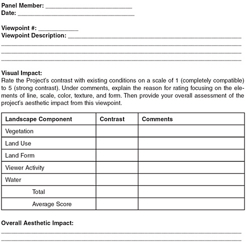
A field inventory of views of all public viewpoints within a 10-mile radius of the project provides the basis for evaluating the extent of visibility as well as the visual characteristics of views in the study area. In addition to photographically documenting and mapping viewing locations, the following information should be recorded: distance from project, duration of view,2 characteristics of the view (intermittent, panoramic, and foreground, middleground and background elements in the view) (Table D-1). Views should be recorded from parks and recreations areas, hiking trails, natural areas, wilderness areas, designated scenic areas or roads, areas with panoramic views, village or town centers, water bodies, state and federal highways, designated scenic roads, other roads receiving heavy traffic (the U.S. Forest Service defines this as an average of 150 vehicles/day), areas with concentrations of residences, and historic sites. Any sites noted in local, regional, and state planning documents as having scenic, recreational, cultural, or natural values can be considered to be potentially sensitive sites.3 Some viewpoints are more sensitive than others because of differences in viewer expectations, the duration of view, proximity to the project ridges, or the scenic quality of the viewpoint.
TABLE D-1 Sample Summary of the Characteristics of Inventoried Viewpoints
|
VP# |
Location |
Distance from Turbines (miles) |
Extent of View Duration or Area |
|
1 |
Rt. 9 East of Wilmington SIMULATION POINT |
4.8-8 |
0.6 mile; intermittent views for 2.5 miles into Wilmington |
|
2 |
Fire Tower Molly Stark State Park |
6.5 |
Point |
|
3 |
Stowe Hill Road |
6-6.5 |
0.4 mile; plus 0.4 mile intermittently |
Visual assessment is particularly important in sensitive areas. Residential areas generally cannot be inventoried in detail, but information can be provided about the number of residences that may be affected. In addition to views of the project ridges, other scenic features within the study area need to be documented.
Public Participation in Identifying Viewpoints
For people who live, work, and recreate in a region, the landscape consists of layers of meaning that may not be understood by an outside professional conducting a visual assessment. If local residents and other interested parties can participate in the selection of sites to be inventoried
|
Description of Existing View |
Relationship of New Turbines to Existing Context |
|
For travelers heading west on Route 9, views begin near the top of the ridge just east of Molly Stark State Park. Views focus on a sequence of hills to the west including rounded foreground hills and the flat ridge with the existing turbines near the center of this view. This view is relatively narrow. West of Lake Raponda Road, views become difficult to see due to foreground trees, hills, and buildings interfering with the view. The fire tower offers a 360° view of the myriad hills, mountains and ridges in the area. Since it is close to the ridge dividing Wilmington from Marlboro and Brattleboro, it offers views much farther to the east and west than anywhere else in the area. A communications tower can be seen in the foreground. The fire tower is a popular hike especially during the summer and fall. Broad views open up around White Road. Due to trees along the road the views alternate between the southern hills and; or to the northern mountains, Haystack and Mt. Snow. The existing turbines are easily visible but appear as a small part of the overall view. Several houses are in the foreground view. |
The turbines along the eastern string will be visible along the background ridge, and will be in the center of the view. Several of the western expansion turbines will be visible behind the existing turbines but will be farther away. As travelers descend into the Wilmington valley, closer hills and ridges will increasingly interfere with the view of the turbines. Rt. 9 is the gateway into the Wilmington valley. The proposed towers will be easily visible from this vantage point. They will occupy a small portion of the overall view, and will be seen in the background of the view. The larger size of the new turbines will make them more visually dominant. A foreground hill will partially obscure some of the eastern string of turbines. The turbines will not be visible in the northwestern views of Haystack and Mt. Snow. |
and the simulations to be produced, the result of the process usually is more widely accepted. Pre-construction surveys of residents, business owners, and tourists can provide a useful complement to public hearings to the degree that they reflect expertise in survey design and are free from bias. Other public-participation techniques are discussed in Chapter 5.
SCENIC RESOURCE VALUES AND SENSITIVITY LEVELS
Evaluating the aesthetic impacts of wind-energy projects ideally begins with an understanding of the elements and locations of the proposed project, as well as particular visual characteristics of the surrounding area that contribute to or detract from scenic or visual quality.
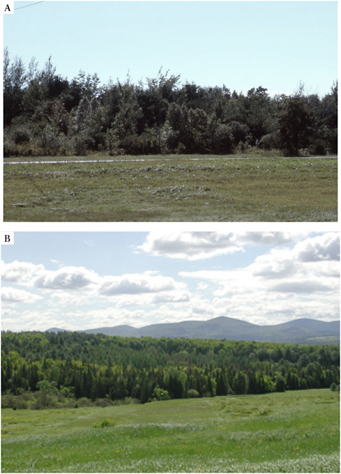
FIGURE D-5 Examples of landscapes of increasing visual diversity. (A) Landscape with no topographic and little vegetative diversity. (B) Increasing topographic diversity, some vegetative diversity (meadow, deciduous, and evergreen) and foreground, middleground, and background distance zones.
SOURCE: Photographs by Jean Vissering, Jean Vissering Landscape Architecture.
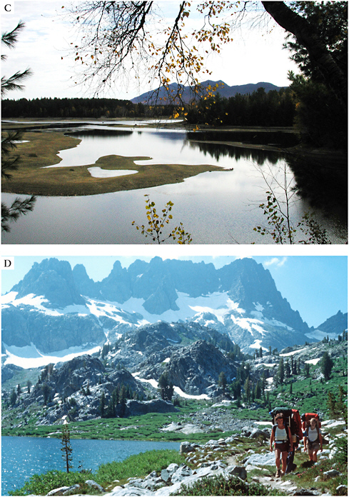
FIGURE D-5 (C) The contrast between high, irregular mountains and the flat lake create a dramatic setting. (D) The combination of highly diverse topography, exposed ledges, water, and vegetation in this scene make it highly scenic.
SOURCE: Photographs by Jean Vissering, Jean Vissering Landscape Architecture.
Regional Landscape Character and Distinctive Features
Landscape character depends on a combination of the natural and human or built landscapes. All landscapes are composed of unique combinations of topography (land form), vegetative patterns, and water features (lakes, rivers, streams, wetlands) that contribute to visual character. Superimposed on the natural landscape is the human or built landscape, also characterized by distinct patterns. For example, patterns of towns or villages may contrast with patterns of farms, fields, and forests. Some regions are characterized by numerous hills and ridges, while others have only a few distinct and prominent ridges or mountains. In some landscapes, certain natural or cultural features become focal points. Forestry practices, mining, suburban development, and recreational structures also are superimposed on the landscape and become part of its overall visual character.
Identifying Important Scenic Resources, Focal Points, and Unique Areas
Processes for determining relative scenic quality are well documented (USFS 1974, 1995; MADEM 1982; RIDEM 1990) (Box D-1). As noted above, however, these processes need to be combined with public review since landscape features that are locally or regionally valued may not be obvious to outside professionals. Identifying areas of high, medium, and low scenic quality is not difficult, although scenic quality is relative. A highly scenic area in upstate New York, for example, looks different from a highly scenic area in the Rocky Mountains. Scenic resources may be of local, regional, statewide, or even national significance. The underlying visual principles, however, are the same. Scenic quality alone is not necessarily sufficient reason to exclude a wind-energy project.
ASSESSMENT OF AESTHETIC IMPACTS
Factors affecting the visual impacts of a wind-energy project are listed below. The first set of factors concerns the particular landscape characteristics of the site and its surrounding context that may affect the sensitivity of views and the degree of aesthetic impact. The second set of factors relates to the characteristics of the project itself, how it is seen in these views, and how these may affect the overall experience of the landscape context. Visual impact assessments consider the combined effects of a proposed project throughout a region or on a locality as it is seen from all views, and particularly from sensitive viewpoints. No single view is likely to create serious impacts. Wind-energy projects inevitably are visible, but how they are seen within views, their relative prominence as seen throughout the region, and the degree to which they interfere with regional focal points or degrade unique or highly sensitive landscapes are important factors.
|
BOX D-1 Principles for Determining Scenic Quality
|
Factors Affecting the Landscape Context
-
Distance from the Project: In general, visual impacts are greater when objects are seen at close range (Figure D-6A-B; compare Figure 3-3 for a close view of the Mountaineer facility in West Virginia). In foreground
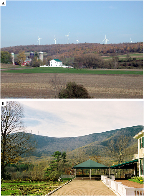
FIGURE D-6 View of wind-energy projects at various distances. (A) Madison Wind Project, Madison, New York from approximately 1 mile. (B) Simulation of proposed Equinox Wind Project in Manchester, Vermont, at 2.4 miles.
SOURCE: Photographs by Jean Vissering, Jean Vissering Landscape Architecture; simulation by EDR for Bennington County Regional Commission.
-
areas (up to a half-mile away) details can be seen and objects appear large and often occupy a large part of one’s overall view.4 Middle-ground views extend up to 5 miles away.5 At this distance landscape patterns can be perceived, as can individual wind turbines, although they will appear smaller and part of a larger context than turbines in a foreground view. Background views are those greater than 5 miles where larger landforms tend to dominate the view. Wind turbines may be seen from 15 miles away, and even farther under optimal atmospheric conditions, but they appear very small at such distances, and appear as small portions of a larger panorama. Noise also diminishes with distance, and is of greatest concern within a half-mile (Chapter 4). Shadow flicker is also experienced only within close range (Chapter 4).
-
View Duration: View duration refers to how long the project is visible as one drives along a road or paddles along a lake, for example. In many cases views of the project may be intermittent and seen through groupings of trees or buildings as one moves through the landscape. As with all considerations, view duration is evaluated along with other factors such as the distance of the project, sensitivity of the viewing area, and prominence of the land feature involved.
-
Angle of View: Whether the project is seen directly ahead in views or to one side may influence the degree to which it is likely to be a focal point in views. Viewing a project from above usually makes roads and site clearing more visible than if seen from below.
-
Panoramic versus Narrow View: When one sees a project as part of a wide panorama, it may appear to occupy a relatively small part of the view unless a particular landscape features make it a focal point.
-
Scenic Quality of View: Highly scenic views are generally those with a high degree of landscape diversity, and with little or no landscape degradation (Figure D-7). Landscape degradation results from development that erodes existing scenic landscape patterns, or land uses that become unintended focal points due to their contrast in form, color or pattern with their surroundings. Panoramic views of high scenic quality are considered to be visually sensitive.
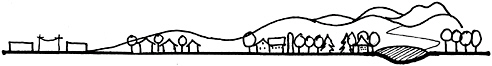
FIGURE D-7 Diagram of increasing scenic quality.
SOURCE: Jean Vissering, Jean Vissering Landscape Architecture.
-
Focal Point within a View: Distinct cultural or natural focal points often enhance scenic quality (Figure D-8). When a focal point exists, new development will generally be more adversely perceived if it conflicts with or degrades the visual quality and prominence of a focal point.
-
Number of Observers: Heavily used public areas, such as a heavily traveled road or a popular recreation area, are sometimes considered to be more sensitive than other areas. This criterion needs to be compared with other factors such as viewer expectations (below).
-
Viewer Expectations: For certain uses there may be expectations for a primitive setting (wilderness camping) or for a natural setting (natural area) (Figure D-9A,B). Recreational areas restricted to non-motorized uses may be more sensitive to changes involving built elements than other settings.
-
Documented Scenic Resources: Local, regional, or state planning documents that have been publicly adopted and that identify a particular site or area as having particular values merit serious attention. National and state recognition may carry greater weight than local recognition, but the latter still is worthy of attention.
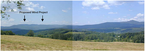
FIGURE D-8 Haystack Mountain is a regional focal point due to its pyramidal shape (right). The proposed wind project would be located quite far away and along a less visually distinct ridgeline.
SOURCE: Photographs by Jean Vissering, Jean Vissering Landscape Architecture.
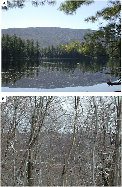
FIGURE D-9 Viewer expectations. (A) Water bodies used exclusively for nonmotorized boats may be more visually sensitive than those used predominantly by motorized craft. (B) Wilderness areas can be considered highly visually sensitive, but are often predominantly wooded. Nevertheless, there may be views during leaf-off conditions that should be inventoried.
SOURCE: Photographs by Jean Vissering, Jean Vissering Landscape Architecture.
-
Visibility: Projects that would be seen with great frequency within the study area may have higher impacts than projects that would be seen infrequently. Visibility must be studied along with the sensitivity, resource values, and prominence of the project within the views for an adequate assessment.
-
Weather Conditions: Generally, projects are evaluated using “worst-case conditions,” e.g., leaf-off visibility and clear skies. An abundance of clear skies makes aesthetic impacts in that area no worse or better than visual impacts in a region that has more cloudy skies. Indeed, a scenic view that is only rarely visible may be even more highly valued than one that usually can be seen.
Project Characteristics That May Affect Scenic Resources
-
Scale: We perceive the size of an object in relation to its surroundings. The actual size of a wind turbine is less relevant than its perceived size in relation to its surroundings. Vertical scale (apparent height) in relation to the associated landmass, horizontal scale, and the overall project size are relevant. Despite the height of modern wind turbines, it is difficult for most people to distinguish between a 200-foot turbine and a 400-foot turbine unless they are side by side. Both appear much larger than surrounding trees and buildings, but the size becomes relevant in most cases only when it begins to appear to diminish the size and importance of a nearby natural feature such as a ridgeline.6
Horizontal scale contributes to the relative prominence of the project throughout the region. Certain western landscapes can accommodate larger projects than eastern landscapes of smaller scale. Projects may be too large when turbines become a constant occurrence within a landscape and when it is difficult to enjoy any views or ridgelines without wind turbines. Overall project size appears to be a significant issue in public acceptance of wind-energy projects in the United States (Figure D-10) (Pasqualetti et al. 2002).
-
Number of Turbines in the View: The number of turbines visible at any one time may affect the prominence or relative scale of the project (Figure D-11). When wind turbines would be seen looking in all directions, or entirely covering the major landforms within a locality, the project may be viewed negatively, and further study probably will be needed.
-
Visual Clutter: The accumulation of diverse built elements on a site, especially elements that contrast with their surroundings in form, color, and texture, can result in visual clutter (Figure D-12A,B). While it may seem
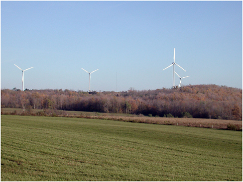
FIGURE D-10 This project in Fenner, New York, generally works well in this high-elevation rolling agricultural landscape. The vertical relationship of turbines to distinct hills or ridgelines needs to be examined in simulations. The ridge above does not appear as prominent from most vantage points, but the issue could arise in other situations.
SOURCE: Photographs by Jean Vissering, Jean Vissering Landscape Architecture.
FIGURE D-11 Simulation of a proposed project in the Berkshire Mountains in Massachusetts. The proposed project would occupy only a portion of this longer ridge.
SOURCE: Photographs by Jean Vissering, Jean Vissering Landscape Architecture.
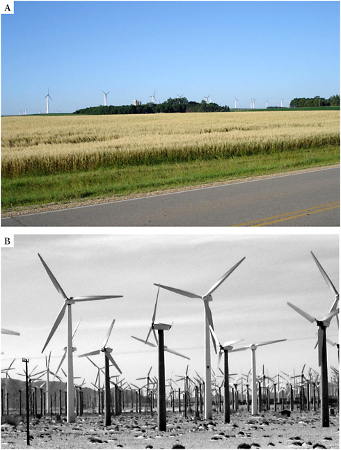
FIGURE D-12 (A) The repetition of identical elements that is characteristic of wind-energy projects helps to create a sense of order. (B) The valley location at San Gorgonio (Palm Springs, CA) diminishes the scale of this large project, but the overall accumulation of different turbine types results in a much more cluttered appearance than is likely in future project planning and maintenance.
SOURCE: (A) Photograph by Sandy Wobeck, East Montpelier Gully Jumper; (B) Photograph by David Policansky.
-
logical to place wind-energy projects in already-built landscapes, too much development can result in an increasingly chaotic or cluttered landscape. Because wind-energy projects involve the repetition of like elements, they often result in greater unity and less clutter than some other types of development. Even combining wind turbines with cell towers may increase visual clutter and therefore, visual impact. The introduction of different sizes and types of wind turbines over the life of a project can potentially severely degrade a landscape (Gipe 2003).
-
Visibility of Project Infrastructure: Visibility of project roads, power lines, substations, and other infrastructure can substantially increase visual clutter (see above) and therefore visual impacts. These also increase the perceived scale of a project. In wooded landscapes, clearing resulting from installation of roads, power lines, and grade changes can visually alter a forested landscape.
-
Noise: To the extent that noise degrades the character and experience of a particular landscape, it is an aesthetic concern. Most modern turbines are relatively quiet, but noise can be an aesthetic concern primarily for residents living within half a mile of a wind-energy project. Careful siting of individual wind turbines as well as selection of turbines rated for low noise can help to reduce these impacts.
-
Lighting: Night lighting can be one of the most difficult aspects of a wind-energy project to evaluate, and may result in some of the greatest concerns. The importance of changes in landscape depend on where it occurs on the continuum of urban to wild landscape, as well as the project’s overall visibility and proximity. In many landscapes where projects have been built or proposed, there currently is little night lighting. Red lights have less contrast than white lights with the night sky in terms of value, but they differ markedly from colors typically observed in the night landscape (except where other objects occur with obstruction lighting).
Other Issues Affecting Visual Impacts
-
Cumulative Impacts: This issue relates both to the expansion of existing projects and to the addition of new projects within a geographic area. The first possibility raises concerns of the overall project scale and its appropriateness for the particular landscape. The second raises concerns of both scale and overburdening a particular locality with development impacts. Developing state-wide or region-wide siting guidelines can help prevent the undue impacts that may result from numerous projects being proposed over time within certain areas.
-
Meaningful Benefits: Perceptions of aesthetic attractiveness are often linked to real or tangible benefits. For many people, however, the benefits of “cleaner air” or “less dependence on foreign fuels” may seem
-
too intangible, and usually they occur at least in part away from the areas subject to aesthetic impacts. Linking wind-energy development to both economic benefits at the local level and a meaningful program of pollution reduction at the state, local, and federal levels can enhance public perception of the benefits of wind energy. Developing direct community participation and links to the wind-energy projects they are hosting also can help these projects become a meaningful part of “place” (Pasqualetti et al. 2002).
Other Methods for Identifying Aesthetic Impacts
Public Participation and Surveys
Communities around the country have used a range of techniques for eliciting public opinions, and the effectiveness of these approaches needs further study. When a specific project is proposed in a particular area, the focus must be on understanding the site and the perceptions of the community members who live and work in the area. Aesthetic effects are sitespecific and individual communities react differently. There is considerable evidence that public acceptance increases with a sense of involvement in the project. Involvement includes active efforts to inform neighbors, providing thorough analyses, responding to expressed concerns with alterations in project design, and providing material or monetary benefits to affected individuals or to the community at large.
Much of what we know about public reactions is anecdotal. Statistically valid and independently conducted pre- and post-construction surveys provide useful information about public perceptions of wind-energy projects and help determine what factors are important in public perceptions. Such surveys are commonly conducted in Europe, but much less often in the United States. To permit generalization of information gathered from public perceptions, surveys need to be carefully designed to factor in particular project attributes, site features, and the public processes followed in presenting the project to the public (Priestly 2006). Attitudes of nearby residents and recreational users from elsewhere may be quite different.
Independent and Peer Review
Experts in aesthetics hired by developers may be perceived as biased in favor of the developer. Two approaches have been used for obtaining independent reviews of proposed wind-energy projects. Some state or local governments hire independent experts to conduct visual impact assessments. In other states a process of peer review is used. Two or more independent experts in aesthetics review the work of the developer’s consultant. Usually they are presented with project information including visibility maps, simu-
lations, and photographs of landscape character. They are asked to evaluate a number of sensitive viewpoints for which simulations have been prepared and to score the degree of contrast resulting from the proposed project. This process could easily be institutionalized by reviewing bodies. In both cases, the developer generally pays for this independent review process.
MITIGATION TECHNIQUES
Some visual impacts will be inevitable with any wind-energy project. Reducing or minimizing negative impacts can be achieved in a number of ways. A well-sited and designed project will have incorporated some of the techniques into the original application. If there appear to be significant visual impacts resulting from the project, additional mitigation approaches can be used. If none can adequately reduce the visual impacts, the project may be found to be unsuited for the particular site. Mitigation techniques include the following:
-
Appropriate Siting: This critical mitigation technique involves avoiding a site that is located on valued regional scenic resources, or that appears very prominent throughout a region. Selecting a site that can comfortably accommodate the number of turbines desired without visually overwhelming sensitive scenic resources on or near the site and the region as a whole also is important. Appropriate siting may also need to address potential issues of cumulative impacts (see below) so that a particular area or landscape type is not overburdened with wind-energy development.
-
Downsizing: Reducing the scale of the project (numbers of turbines or height of turbines)7 can help the project fit more comfortably into its surroundings. In some cases one or more turbines may be particularly prominent from sensitive viewpoints, or the overall scale of the project may overwhelm the particular land form or surrounding landscape. In most settings the difference in overall turbine height are difficult to distinguish. The difference between a 200-foot turbine and a 360-foot turbine (hub or nacelle height) can be difficult to perceive, especially when the turbines are seen against the sky. Size may make a difference if the height of the landform begins to be overwhelmed by the height of the turbine. Generally, fewer larger turbines can result in a better visual outcome than a larger number of smaller turbines.
-
Relocation: Moving turbines from one location to another can help, but it may not be possible in all cases. Relocation can be used to
-
avoid proximity to residences or visual prominence from sensitive viewing areas.8
-
Lighting: The revised Federal Aviation Administration (FAA) lighting guidelines reduce lighting impacts. Lighting impacts often are of greatest concern to residents and recreationists, and should be minimized to the greatest extent possible. Any new technologies or modification of FAA lighting requirements that can further reduce lighting for wind turbines ideally should be incorporated into design standards.
-
Turbine Pattern: In most cases turbines are located to take advantage of small rises in the land, flatter terrain, or other site features that determine their pattern or organization on the ground. Some studies suggest that turbine configurations can be designed to respond in meaningful or visually pleasing ways to their surroundings. In rolling landscapes a less rigid arrangement that reflects topography may be preferable, while in flatter landscapes, especially with patterns of rectangular fields or roads, a more geometric or linear pattern may work better. Simulations provide a useful way to study the effects of different turbine patterns from sensitive viewing areas.
-
Infrastructure Design: Paying attention to project infrastructure such as meteorological towers, substations, power poles, and project buildings in addition to the turbines themselves is important. Generally, it is advisable to screen all project infrastructure from view to the greatest extent possible.
-
Color: A recent FAA study showed that daytime lighting could be eliminated provided that turbines are white. White often is regarded as more cheerful and less industrial than other colors, which may be part of the reason some people find wind turbines more visually appealing than, for example, cell towers. Bright patterns and obvious logos can be avoided. Unobtrusive colors are important in other project infrastructure such as operations buildings, transmission support poles, and road surface materials. In general, darker colors are less noticeable, especially against a background of vegetation.
-
Maintenance: People find wind turbines more visually appealing when the blades are rotating than when they are still (Pasqualetti et al. 2002). Requirements for immediate repairs of wind turbines can be part of permit requirements. Also the replacement of wind turbines with visually different wind turbines can result in visual clutter, so replacing wind turbines with the same or a visually similar model over the lifetime of the project may be an important requirement. Sufficient funds need to be assured for this purpose.
-
Decommissioning: Once a project or individual turbine can no longer function, requirements for removing the project infrastructure and reclaiming the site are important. A plan for decommissioning may be required as part of the permit application. In some cases, money is reserved in escrow for this purpose.
-
Non-reflective Materials: Use of materials that will not result in light reflection may be required, for all project components.9
-
Minimizing Vegetation Removal: Ideally, existing vegetation should be retained to the greatest extent possible. Clearcuts generally have negative visual impacts (Brush 1979). Screening areas of cleared forest may be advisable, as well as maintaining vegetation along roadsides and around turbines.
-
Screening: While turbines cannot be screened from view, other project infrastructure (roads, power lines, substations, and buildings) can be. Existing vegetation is usually preferable, but plantings may be needed and should incorporate typical indigenous vegetation.
-
Noise: Noise and siting standards can help reduce impact on residents near the project (generally within half a mile). Noise standards can be set at firm levels such as 40 dB(a)h (decibels corrected or A-weighted for sensitivity of the human ear) nighttime and 50 dB(a) daytime at the property line or at residential structures; or can be set as an increment above ambient noise levels (e.g., a maximum of 5 dB(a) above ambient noise levels). Post-construction monitoring is important here as in many aspects of the impacts of wind-energy facilities.
-
Burial and Sensitive Siting of Power Lines: Collector lines often are buried between turbines. In very sensitive viewing locations other collector and transmission lines may also need to be buried (see Figures 3-2A and 3-2B).
-
Offsets: In some cases protecting an offsite visual resource can help to offset the impacts of the project if mitigation cannot be accomplished on site.
DETERMINATION OF ACCEPTABLE OR UNDUE AESTHETIC IMPACTS
Decision makers usually need guidance to evaluate under what circumstances the degradation of aesthetic resources may outweigh the benefits of a proposed project. The immediate question may be: would this particular project result in undue harm to valuable aesthetic resources in this particular setting? At a policy level, the question is broader: how can wind-energy projects be accommodated while retaining the valued scenic resources of
the state and of individual communities? These questions can be addressed systematically using the process described above and relying on well-established aesthetic principles. Many sites are likely to be suited to wind-energy development, and where these occur, the question becomes: does this project as designed work on this site or will mitigation be required? Mitigation possibilities are discussed above, but there will be circumstances when mitigation techniques fail to address critical problems with the site itself. Visibility alone generally does not result in a wind-energy project’s being perceived as unacceptable. If the project appears to result in many issues, to involve important regional scenic resources, and to significantly affect the ability of people to enjoy these resources, then the project may be perceived as or judged to be unacceptable. Some questions to consider in revieweing wind-energy projects are listed below. Assuming that a high-quality wind site is involved, decision-making agencies may feel more comfortable in concluding that the aesthetic impacts are undue if more than one of the following concerns is involved. Ideally, the criteria will be weighed against the overall public benefits of the project and along with the general suitability of the site in other respects (see Box D-2 and Chapter 5 of this report).
Questions to Consider in Determining Acceptability of Visual Impacts
-
Is the project located within an area of identified scenic or cultural significance?10
-
Would the project significantly degrade views or scenic resources of regional or statewide significance?
-
Is the project on or close to a natural or cultural landscape feature that is a regional focal point?
-
Is the project in a landscape area that is visually distinct and rare or unique?
-
Is the project unreasonably close (usually less than a half-mile) to many residences that would be severely affected, especially as a result of noise, shadow flicker, or by being completely surrounded by wind turbines?
-
Will the project occupy an area valued for its wildness and remoteness? If these values have been specifically documented, then consideration of the appropriateness of a wind-energy project becomes even more important.
-
Would the project’s scale in terms of turbine height or numbers
|
BOX D-2 Maine’s Department of Environmental Protection Visual Impact Assessment Criteria (MEDEP 2003)
|
-
of turbines overwhelm the landscape in which it occurs? (For example, would scenic views that are free of turbine remain throughout the region, or would wind turbines occupy all or most notable ridgelines within view of the area?)
-
Will the project result in unreasonable visual clutter due to its combination with existing built features that already degrade landscape features? This is an issue of cumulative impacts.
-
Has the applicant used reasonable and available mitigating techniques that would reduce the project’s impacts?
-
Does the project violate a clear, written community standard intended to protect the aesthetics or scenic beauty of the area? Such a standard ideally will be legally adopted by a community or state, and provide clear guidance to developers and be based on sound principles of aesthetic resource assessment.