
3
Partnerships with Federal Agencies
The Applied Sciences Program (ASP) uses partnerships with other federal agencies to apply National Aeronautics and Space Administration (NASA) research products in operational decision making. Such partnerships are ASP’s primary conduit to end users. Fourteen federal agencies are involved in these partnerships (Table 3.1), which accounted for roughly half of the projects (75 out of 141) funded through ASP in fiscal year (FY) 2006. This chapter lays the foundation for examining the extent to which the partner agencies and organizations have found that their collaboration with NASA through the ASP is helping them carry out their decision-support goals. The discussion continues in Chapter 5.
This chapter has three parts. First, it presents examples of ASP’s engagement with federal partners. These examples provide a cross section of agency experience and include the U.S. Department of Agriculture (USDA) and Environmental Protection Agency (EPA)—as two of ASP’s longer-term partners—and the National Geospatial-intelligence Agency (NGA), Department of Homeland Security (DHS), and Minerals Management Service (MMS)—as agencies with less mature partnerships. In general, there is great variety in the strength and maturity of federal partnerships (Box 3.1). The second part of the chapter examines the complex relationship between NASA and the National Oceanic and Atmospheric Administration (NOAA). NOAA plays a dual role as an operational home for research sensors developed by NASA and as a user of NASA products. The third part summarizes common challenges encountered by federal agencies in achieving research-to-operations transitions with NASA and identifies aspects of NASA’s process that could be improved.
To produce this chapter, the committee drew on presentations and written input from agency representatives. In addition, the committee presented questions to ASP (Appendix B; ASP, 2006). The committee received ample information from some agencies, particularly NOAA (NOAA Research Council, 2006), either through meeting presentations or material submitted in response to committee questions. Not all ASP partnerships with other agencies were as readily documented.
THE PROCESS OF ENGAGEMENT
A variety of constraints influence ASP’s collaboration with federal partners and its processes to promote collaboration. The committee examined several federal partnerships to understand common elements and areas for improvement. Each of the five examples below describes partner agencies’ requirements, mechanisms used in collaboration with ASP to enhance the partnership process, and the results. The examples begin with the most mature partnerships.
|
BOX 3.1 Unevenness in NASA’s Relationships with Federal Partners NRC (2007a) observed that “new measurements for applications in weather forecasting can be evaluated within the existing structures of NASA and NOAA because those agencies have for the most part worked out the processes by which the importance of such measurements can be evaluated, notwithstanding the known difficulties of transitioning new measurements to operations. However, new measurements for land-cover, geological hazards, or water resources, to mention just a few, do not have existing relationships between client agencies and the space agencies that naturally lead to evaluation of their potential for applications. New measurements that would be relevant to such critical issues as deforestation and the loss of biological diversity or interruption of ecosystem services essentially have no client agency, and must rely on individual university researchers or staff in non-governmental organizations to lobby the space agencies, without benefit of strong institutional ties to those agencies.” |
Table 3.1 NASA Partnerships with Other Federal Agencies in Each of the 12 Application Areas
|
National Application |
Partner Agencies |
NASA Contributions |
Partner Agencies Decision-Support Tools |
Decadal Outcomes of Agencies’ Use of NASA Data and Information |
|
Energy Management |
DOE, EPA |
Extended weather forecasts, seasonal climate prediction, and distribution of incoming solar radiation via Terra, Aqua, SORCE (Solar Radiation and Climate Experiment), CloudSAT, NPP (NPOESS Preparatory Project), GPM (Global Precipitation Measurement) |
RETScreen Natural Resources Canada (NRCan) |
Energy management sources and integration into the power grid through use of RETScreen Location of energy management facilities Biomass crop selection and maintenance strategies |
|
Agricultural Efficiency |
USDA, EPA |
Seasonal temperature and precipitation, extended weather forecasts, and soil moisture via GPM, Aqua, Terra, NPP, Landsat, Aquarius, suborbital |
Crop Assessment Data Retrieval and Evaluation (CADRE) |
Improved crop production assessments Increased agricultural productivity and reliability |
|
Carbon Management |
USDA, EPA, DOE, USGS, USAID |
Measurement of carbonaceous gases and aerosols, terrestrial biomass and marine productivity via Terra, Aqua, Aura, NPP, OCO, and suborbital |
CQUEST tools developed to implement Section 1065(B) of Energy Act of 1992 (EA92) voluntary sequestration of greenhouse gases |
Operational decision-support system (DSS) with improved assessment of carbon sources and sinks for a carbon-trading regime |
|
Aviation |
DOT/FAA |
Improving weather nowcasting, monitoring of volcanic aerosols via Terra, Aqua, NPP-Bridge, GPM, and suborbital, improving cockpit capabilities via:
|
National Aerospace System (NAS) Controller/pilot decision aids Runway incursion prevention |
Enhanced National Airspace System, AWIN (Aviation Weather Information Project), and SVS that reduce the aviation fatal accident rate by a factor of 10 by 2022 |
|
National Application |
Partner Agencies |
NASA Contributions |
Partner Agencies Decision-Support Tools |
Decadal Outcomes of Agencies’ Use of NASA Data and Information |
|
Homeland Security |
DHS, NIMA, USDA, USGS, NOAA, DOD |
Observation and modeling of atmospheric chemical transport and precipitation via Terra, Aqua, NPP, GMP, and suborbital |
Department of Homeland Security (DHS) situation control |
Improved capabilities of homeland security officials to prepare, warn, and response to homeland security threats, especially air and water exposure |
|
Ecological Forecasting |
USGS, USDA, USAID |
Observation of land cover change, vegetation structure, and biomass and use in ecosystem in models via Landsat, NPP, and suborbital |
Models of habitat change Impacts of El Niño |
Enhancing ecosystem sustainability as economics and populations shift and grow |
|
Disaster Management |
FEMA, USGS, NOAA, USDA |
Observations of topographic change and crustal strain and motions, extended weather forecasts via Aqua, SeaWinds, SRTM (Shuttle Radar Topography Mission), Landsat, GPM, and suborbital |
HAZUS (Hazard U.S.) risk Prediction Carrier for Integration of Natural Disaster Information (CINDI) |
Enhanced risk assessment, warning and response for hurricanes, tornadoes, flooding, earthquakes, and landslides |
|
Public Health |
CDC, DOD NIH, EPA, USGS, NOAA |
Observations and modeling of weather, climate, and other environmental factors influencing disease vectors and air quality via Aura, NPP, Jason, GPM |
Environmental Public Health Tracking Network (EPHTN) Arbovirus Surveillance Network (Arbonet) Malaria Modeling and Surveillance (MMS) |
Improved a surveillance systems (Arbonet) Integrated environmental factors into EPHTN Improved accuracy and precision of disease predictions with a corresponding increase in warning time |
|
Coastal Management |
NOAA, EPA |
Measurement and modeling of ocean temperatures, winds, color, and salinity associated with harmful algae blooms via Terra, NPP, SeaWinds, Landsat, Jason |
Harmful Algal Bloom Mapping System/Bulletin (HABMap/Bulletin) |
Improved capability of DSS to forecast HAB initiation, transport, toxic severity, landfall, and demise |
|
Invasive Species |
USGS, USDA |
Observations and modeling of land cover change, biomass, and climate influencing species proliferation in areas where newly introduced, via Terra, Aqua, NPP, Landsat |
Invasive Species Forecasting System (ISFS) |
Operational, robust, and early detection and monitoring of plant invasions to protect natural and managed ecosystems |
|
Water Management |
USBoR, EPA, USDA, USGS |
Improved models of water transport, storage, and quality using observations of snow cover, soil moisture, and topography via Aqua, NPP, GRACE, GPM, Landsat, and suborbital |
RiverWare Better Assessment Science Integrating Point and Nonpoint Source (BASINS) Agricultural Water Resources and Decision Support (AWARDS) |
Improved water quality and quantity assessments Forecasts of precipitation and daily crop water use toward reduction of real irrigation Seasonal predictions for optimum vegetation selection and improved water use efficiency |
|
Air Quality |
EPA, NOAA, USDA, FAA |
Measurements of aerosols, ozone, emissions, and modeling of aerosol and chemical atmospheric transport via Terra, NPP, Aura, Glory, and suborbital |
Community Multiscale Air Quality (CMAQ) modeling system AIRNow and Air Quality Index |
Multiple-day air quality forecasts and robust emissions control planning |
|
NOTE: See Appendix D for Abbreviations and Acronyms List SOURCE: NASA, 2004, p 47-48. |
||||
Department of Agriculture
The mission of the USDA is to provide “leadership on food, agriculture, natural resources, and related issues based on sound public policy, the best available science, and efficient management.” The USDA has a long history of partnering with NASA. The relationship began in the 1970s with the NASA-initiated Large Area Crop Inventory Program (LACIE, Box 1.1) and continued into the 1980s with the USDA-initiated Agriculture and Resources Inventory Surveys Through Aerospace Remote Sensing (AgRISTARS) Program. Those programs led to the operational use of remote sensing data by the Agricultural Research Service, Forest Service, and Foreign Agricultural Service (Box 3.2), among others.
Examples of requirements
USDA has wide-ranging requirements for remote sensing data. These requirements are driven by the need to analyze the health and quantity of trees and crops and the natural resources (water, air, soil) that support agriculture. Such requirements can be grouped under eight themes that align with focus area working groups (FAWGs) set up by USDA and NASA. The NASA/USDA FAWGs are agriculture efficiency, air quality management, carbon management, disaster management, homeland security, invasive species, resource inventory and monitoring, and water management. The FAWG on air quality focuses on a number of new NASA data sources for supplementing ambient air quality measurements of ozone, aerosols, ammonia, and volatile organic compounds. For example, a strong need exists, particularly in USDA’s Forest Service, to measure emission sources of ozone and particulates, because burning on agricultural and forest lands affects regional haze and ambient air quality. USDA activities relating to another FAWG—agricultural efficiency— require higher spatial resolution than is available from NASA. In addition, they need user-friendly data formats and more rapid access to NASA data than is currently available. Activities under the disaster management theme require hyperspectral data, a continuous Landsat data series, and expertise in unmanned aerial vehicles (UAVs). Activities under the water management and conservation theme that already use NASA tools and resources in conjunction with USDA in situ data to forecast water availability have unmet needs for high-resolution hyperspectral data for water quality assessment.
|
Box 3.2 Use of NASA Data by the Foreign Agricultural Service USDA’s Foreign Agricultural Service (FAS) partners with NASA through its Production Estimates and Crop Assessment Division (PECAD) (Doorn, 2006). PECAD’s Crop Explorer (see http://www.pecad.fas.usda.gov/cropexplorer/) has tools for assessing crop production worldwide using various NASA data sources, including MODIS, Advanced Microwave Scanning Radiometer (AMSR-E), and Tropical Rainfall Measuring Mission (TRMM). Landsat has been a key data source for FAS, and the NASA/USDA Global Reservoir and Lake Monitor Project uses lake and reservoir levels from NASA’s Jason-1 satellite every seven to ten days for estimates of lake and reservoir height to develop estimates of irrigation potential. |
Process
Given the long history of USDA-NASA collaboration, this discussion focuses only on partnership processes established under the present iteration of ASP. A USDA-NASA Memorandum of Understanding (MOU) in 2003 established a Federal Interagency Working Group on Earth Science Applications (IWGESA) with a joint funding Announcement of Opportunity through ROSES (Chapter 2). USDA has subsequently supported several projects through ROSES. This ASP-coordinated NASA-USDA collaboration led to formation of the aforementioned FAWGs. The FAWGs are tasked to identify projects for collaborative development by USDA and NASA and to develop prospectuses for these new projects. USDA provides feedback to NASA through these working groups and through publications and reports on activities that use NASA data. In addition, NASA and USDA have held two interagency workshops to fuel collaboration. At the first workshop, held in Denver in 2003, IWGESA initiated several research proposals. The follow-up meeting, in 2005 in New Orleans, assessed progress on proposed collaborations and attracted a wider range of USDA participants.
Results
USDA needs a wide range of data and models to support its diverse applications. The NASA-USDA partnership has supported a subset of these needs. For example, NASA has provided new tools that are particularly useful in the areas of air quality, precipitation, soil moisture, and water resource monitoring. There are unmet needs in applications that involve high-spatial-resolution and hyperspectral remote sensing data, particularly for assessment of disasters and agricultural efficiency. USDA also has requirements for high-frequency, high-resolution multispectral satellite data, but no formal process exists for expressing scale and resolution requirements for such data. Issues of data continuity—particularly
with respect to Landsat—are of growing concern to USDA agencies such as FAS. While this issue is one of policy with respect to the continuity of the Landsat project and not under ASP’s mission, the importance of this project and other data continuity issues to ASP and its partners is clear. ASP’s voice, for its activities and as a representative for federal partners in this larger policy issue, is an important one for NASA to consider.
Environmental Protection Agency
EPA’s mission is to protect human health and the environment. The agency has worked closely with NASA for two decades. In the early 1990s, land cover issues were at the forefront of their interaction. EPA scientists developed remote sensing applications together with NASA scientists at Langley and Ames Research centers. More recently EPA has worked directly with ASP and has tried to provide feedback to NASA through this program.
Examples of Requirements
EPA requires predominantly high-spatial-resolution multispectral data to aid in its decision making. Because of the regulatory nature of EPA and the need for data to withstand judicial scrutiny, the quality and reliability of these data are more important than developing new research applications (Worthy, 2006).
In the federal government only the U.S. Geological Survey's Earth Resources Observation Systems Data Center (USGS EDC) provides such data—from Landsat. Images can cost $400 to $700, although with any image quality problems the imagery may be provided at a lower cost. In addition, many images are free to the public domain outside EDC. EPA does not routinely use commercial satellite data for its operational environmental monitoring because these data are not designed with science quality in mind, they are costly, and the options for data sharing may be controlled by a license agreement.
Process
EPA’s partnership with ASP is focused on application of low-spatial-resolution data. Between 1998 and 2004 EPA used SeaWiFS data in some of its programs. These data were acquired through the NASA data buy (Chapter 1). EPA now uses NASA MODIS data, which are free and provide frequent revisits over the same location. NASA and EPA have used several MOUs or Memoranda of Agreement (MOAs) to define the
formal mechanisms of their partnerships. EPA has implemented these partnerships with an employee dedicated to developing tools with NASA.
Results
Formal arrangements and a direct liaison working with NASA have helped facilitate the partnership process and created the potential for establishing EPA’s requirements. Unfortunately, NASA and ASP have had difficulties dedicating staff to these interactions. In addition, NASA’s competitive process for funding projects has slowed some project development. It is possible for EPA to pay for internal projects through base funding, and EPA believes direct funding to some collaborative projects may expedite the process of transferring research to operations. Additional resources as well as greater continuity in formal partnership mechanisms may also strengthen the feedback loop from the EPA user community to NASA.
National Geospatial-Intelligence Agency
The NGA has had a relationship with NASA since 2003. Its mission to supply geospatial information to the defense complex and to society requires multiscale, multiresolution data with global coverage. In addition to supporting military operations, these data are used in such applications as environmental assessments, ground planning, and disaster support. Where possible the agency uses unclassified data and fuses these data inhouse with classified images (Powers, 2006).
Examples of Requirements
NGA routinely uses NASA data (e.g., from MODIS) though they also require higher-spatial-resolution multispectral data than are available from NASA. While some NASA data formats require extra processing for use by NGA (for example, the MODIS data), NASA data quality is considered good for NGA applications. Because open use of the Internet compromises NGA’s network security, one common additional requirement is a direct data feed through nonpublic channels.
Process
NGA demonstrated its commitment to use of NASA products by appointing a full-time liaison at NASA in 2003. The liaison facilitates communication of needs and requirements. There are, however, no other
formal arrangements that could provide a complete cycle of requirements establishment, feedback, and transition of NASA research to operations.
Results
NGA acknowledges that NASA has always been responsive to its needs but has not requested feedback. In addition, NGA notes that a NASA help desk would be useful. With respect to assisting with NGA’s data needs in the long term, there is no NASA-NGA mechanism to develop new technologies to support pressing NGA requirements for high-frequency, high-resolution multispectral satellite data. In general, under the current arrangement NGA uses what it can obtain from NASA until the source is either put into operation by another agency or is discontinued.
Department of Homeland Security
The NASA-DHS relationship is young, evolving, and has yet to be formalized. DHS is involved in all phases of disaster management and is responsible for providing data to a multitude of users, from policy- and decision makers to field workers across a wide range of agencies. DHS is primarily a data user, not a producer, and works closely with NGA, NOAA, and USGS to acquire data. DHS also uses data that originate at NASA (from orbital and suborbital sources) and the USDA National Agricultural Imagery Program, among a number of freely available sources. From the standpoint of DHS, the focus of use for remote sensing data is toward emergency or disaster response, recovery and mitigation. Examples of applications include oil seepage detection, detection and scope of metropolitan power outages, natural disaster response (tornadoes, hurricanes, floods, and wildfires) (Barnard, 2006).
Examples of Requirements
Many of the DHS agencies require frequent high-spatial-resolution multispectral, multiplatform data, and on occasion live and dynamic data feeds. In addition, DHS wants unclassified data that are available to responders on the Internet for the most rapid dissemination.
Process
In DHS one person at FEMA coordinates GIS and remote sensing with all relevant agencies and directs selection of the appropriate remote sensing data for a given situation. DHS consults with the U.S. Army Corps of Engineers (USACE) on data interpretation. Amongst the 12 spectral satellite systems available and appropriate for use by DHS in 2006, four of the systems were NASA’s.
Results
Currently, DHS is a consumer of NASA products, and no formal mechanism exists for ASP to help develop new technologies to support DHS requirements. Placement of a NASA employee with remote sensing expertise on detail at DHS occurred for a brief period and was deemed successful in encouraging initial interactions between DHS and NASA through ASP (see Section 3.3.2 for these itemized formal agreements). Otherwise, DHS has relied primarily on other federal agencies to provide processed NASA data to meet their decision-support needs and to speak to NASA about its data requirements. A primary issue for a relatively new agency like DHS has been to establish its own requirements, prior to making direct communications about these requirements to agencies like NASA (Barnard, 2006). As DHS’ requirements crystallize, identification of specific persons within DHS to serve as contacts with NASA and ASP was suggested as an additional practical step for DHS to follow to foster better communication with NASA.
Minerals Management Service
The Minerals Management Service (MMS) of the Department of the Interior manages the nation's oil, gas, sand, gravel, and other mineral resources on the seafloor in the U.S. Exclusive Economic Zone (EEZ). The MMS has increasing responsibilities for managing and leasing of outer continental shelf (OCS) areas for activities related to offshore wind energy, wave energy, ocean current energy, offshore solar energy and hydrogen generation, and programmatic environmental impact statements (EISs). The MMS’s geographic focus is the Gulf of Mexico, which is home to over 95 percent of U.S. offshore oil and gas production, although there is still some offshore production in Southern California and limited leasing and exploration in federal waters off Alaska (Lugo-Fernandez, 2006). MMS relies on accurate oceanographic and weather forecasts to make decisions that impact the nation's energy and offshore mining processes.
Examples of Requirements
NASA satellite images provide a unique means to observe and monitor the EEZ frequently, repeatedly, and in a synoptic manner. Using these images, MMS works with industry to monitor and understand oceanographic conditions such as eddies and currents. Such water motions are of particular interest because they affect drilling operations and dispersal of spills. Eddies can result in shutdown of drilling operations, and strong ocean currents and winds (Figure 3.1) can damage equipment and cause substantial economic losses.
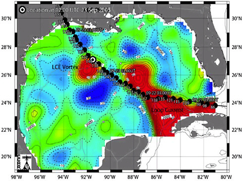
FIGURE 3.1 Path of Hurricane Rita over the Loop Current and Loop Current eddy "Vortex" in the Gulf of Mexico. Image shows color map of sea surface height overlaid with the National Weather Service observed and predicted path and maximum sustained wind speed for the hurricane from the 7 am CDT forecast on September 23, 2005. High sea surface height (red) is associated with very deep and warm waters of Caribbean origin. Altimeter data from the NASA/CNES Jason-1 and T/P, ESA Envisat, and U. S. Navy Geosat Follow-on altimeter satellites were used to map the height field. Hurricane Rita passed over the main concentration of U.S. outer continental shelf oil and gas drilling operations in the Gulf. SOURCE: Courtesy of Dr. Robert Leben of University of Colorado
Process
MMS has no formal mechanisms for dialogue with NASA. Nonetheless, MMS uses NASA data and, mostly over the last decade, has awarded contracts (including those for 43 oceanographic projects) for environmental research and monitoring.
Results
The MMS-NASA relationship is an example of an agency’s reliance on NASA data without a formal partnership that includes official contacts or a means to impact sensor specifications by communicating observational requirements.
NASA’s RELATIONSHIP WITH NOAA
NASA’s relationship with NOAA is different from those described above because NOAA is both a user of NASA products and a conduit for extending NASA products into an operational setting (Box 3.3). This section covers both facets of this relationship. The first element of discussion in this section is NOAA’s operational use of NASA data. This is followed by discussion of the research-to-operations transition. NOAA, through its Research Council, was particularly responsive to the committee’s questions (NOAA Research Council, 2006). Quotes from the council’s response are used throughout this section.
|
Box 3.3 Example of the Complexity of the NASA-NOAA Relationship NOAA’s National Environmental Satellite, Data and Information Service’s (NESDIS’s) Center for Satellite Applications and Research (STAR) has extensive interactions with NASA in (1) remote sensing instrument development, (2) remote sensing research, (3) calibration/validation of new instruments and products, and (4) real-time use of experimental satellite products. Several staff members of STAR were on the Atmospheric Infrared Sounder (AIRS) and MODIS science teams and provided science and guidance, from an operational perspective, for the development and use of those instruments. STAR provided the routine ground truth buoy data (Marine Optical Buoy, MOBY) for calibrating the MODIS ocean color bands and products; STAR scientists on the AIRS science team contributed atmospheric profile retrieval algorithms and methodology to test the usefulness of AIRS data for numerical weather prediction. MODIS data are used operationally by NOAA to derive wind vectors over the polar regions. These polar winds have had a measurable impact on the accuracy of numerical weather forecasts. The AIRS is proving to be an excellent test instrument for future operational hyperspectral atmospheric sounders such as the Infrared Atmospheric Sounding Interferometer (IASI) and Cross-track Infrared Sounder (CrIS). SOURCE: NOAA Research Council (2006). |
NOAA as a User of NASA Products
The National Center for Environmental Prediction (NCEP) is a major operational processing center in NOAA’s National Weather Service (NWS). The NOAA Coastal Services Center (CSC), part of the National Ocean Service, supports decisions on coastal management, recreation, and hazards. Both NOAA centers use NASA data.
National Center for Environmental Prediction
NCEP produces weather and climate analyses and forecasts derived from NOAA, NASA, and other data sources (e.g., radiosonde networks, radar networks, surface stations) to NWS field offices, the public and private sector, and academia. NCEP, or its equivalent predecessor, has used NASA data since the early 1960s.
Examples of Requirements
NCEP relies heavily on a range of models and satellite and surface weather observations to complete its mission. In addition to relying on NOAA’s operational data sources, NCEP draws on many NASA satellites (e.g., MODIS, Box 3.3; TRMM [NRC, 2005a]; and TOPEX, JASON, Box 3.4). NCEP operationally uses models and methodologies developed by NASA (e.g., Box 3.4).
|
Box 3.4 NOAA Application of NASA Data and Models The NOAA Research Council presented the following as examples of successful applications of NASA data and models in NOAA:
SOURCE: NOAA Research Council (2006). |
Process
Despite a long history of NCEP use of NASA data and models, there is no formal mechanism to transmit, review, revise, and develop requirements. One source of optimism is the Joint Center for Satellite Data Assimilation (JCSDA) (NRC, 2007b), whose participating members include the Department of Defense (DoD), NASA, and NOAA. The participants’ shared goal is to accelerate the use of satellite data in numerical weather prediction. The center provides resources and scientific interactions that facilitate timely use of NASA experimental satellite data in operational models.
Results
NOAA’s input to the committee underscored the cultural differences between agencies with research and operational missions. NCEP emphasized that its requirements are not well understood or appreciated by NASA. The stringent steps required for operational assessment, acceptance, and implementation require careful and continuous coordination by agency managers to ensure that the academic community is provided with a clear set of requirements to focus the research, and that the results of the research are then implemented. The NOAA response to the committee stated,
Yet, the difficulties involved with the transition from research to operations are still not fully appreciated by either the research community, the operational community and especially the policy and budget community: From a sociological point of view, the stringent steps required to modify operational systems and related software (that assures operational product delivery) are viewed by the research community as a roadblock. From a budgetary point of view, the resources required to assess and implement new procedures and related IT [information technology] infrastructure are underfunded by both sides, and no one really wants to assume these costs. NOAA Research Council (2006).
In the past, a program called OSIP facilitated the transition from research to operations. To further quote the NCEP response to the committee:
One bright spot in the transition process involved the satellite community. In the beginning of the satellite era in the 60's and early 70's, NASA and NOAA worked through the ‘Operational Satellite Improvement Program’ (OSIP) in true partnership to test
satellites, assess the data and validate the instruments (NASA lead), before deploying and sustaining an operational satellite network (NOAA). The rapid spin up of the GOES [Geostationary Operational Environmental Satellites] program came out of this effort (among other success stories). OSIP was halted in the 1980s by a mutual agreement between NASA and NOAA. With the demise of the OSIP went the strong inter-agency support for the satellite R2O [research to operations] transition process, and here we are today.
According to the NOAA Research Council the process for stating requirements is informal, with NASA making the final decision on research projects they fund. JCSDA has identified a need for high-frequency, high-resolution multispectral satellite data from NASA. Yet, even with NASA’s involvement in the JCSDA, there is no mechanism to influence new research on space technologies that would lead to future satellites and products designed to address requirements not satisfied with existing NASA data. Since the demise of OSIP, no formal program exists for NASA to develop and test new space observation systems that would make the transition into NOAA operations. Furthermore, NASA no longer necessarily accepts the responsibility to develop and space test future satellite systems needed by NOAA to improve operational weather forecasting. The Geostationary Imaging Fourier Transform Spectrometer (GIFTS), which is capable of enabling revolutionary improvements in hurricane and severe convective storm (including tornado) predictions, is an example of a new system not being space demonstrated by NASA for NOAA. NASA did fund the development of a highly successful GIFTS Engineering Demonstration Unit. The space demonstration of GIFTS by NASA and NOAA was recommended in the Decadal Survey (NRC, 2007a) report. This is one example of the “disconnect” in the space system responsibilities shared by these two agencies, and underscores the sense that broader issues than just those under ASP’s purview require resolution in order for ASP to be as effective as expected in its “bridging” role.
In general, there is no clear sense at NCEP of which programs need mutual support by NOAA and NASA. Success depends on the overall investment and balance of investment among observations, computational power, and research and transition support. On the observational side, airborne and surface systems receive fewer resources than space systems (Box 3.5) even though the former could contribute to high-resolution data needs of the community. Support for computational power and research and transition support is also inadequate. This has, for example, caused a multiyear backlog of new satellite products waiting at JCSDA to be tested before they can be used operationally (NOAA Research Council, 2006).
Coastal Services Center
The Coastal Services Center (CSC) has attempted to integrate NASA data into its work since the mid-1990s.
Examples of Requirements
CSC uses remote sensing data to achieve performance goals relating to (1) build regional capacity to address coastal hazards and other weather and water conditions, (2) adequately characterize coastal and marine areas for management, and (3) improve ecosystem management through tools, technologies, and information services used by NOAA partners and customers. Operational data are required for several applications to implement decision-support tools. CSC performance is gauged by the number of such tools generated and their usability.
CSC customers and partners work on topics that generally require higher spatial resolution multispectral data than are available from NASA. In many cases customers also require a higher temporal and spectral resolution. Consequently, CSC often turns to private sector vendors to collect and process data for decision-support tools. Where requirements are less restrictive, CSC works with NASA and the private sector on data and tools development (Box 3.6).
Process
Collaboration between NOAA/CSC and NASA is informal—through in-kind contributions in the case of the Harmful Algal Bloom (HAB Forecasting System. There is no formal mechanism for communicating data needs and results back to NASA, and there is little funding from CSC for the NASA science community or interaction between the two groups.
|
BOX 3.5 Insufficient Resources for Airborne and Surface Systems “There are insufficient resources being allocated to airborne and surface systems, which can be more responsive and produce higher data quality than space systems for high-resolution requirements. Current surface, in situ, and seafloor instruments are insufficient to provide the spatial coverage and integrated knowledge necessary to ground-truth and calibrate space and airborne imaging systems.” SOURCE: NOAA Research Council (2006). |
|
BOX 3.6 Coastal Services Center Partnership with NASA and the Private Sector The NOAA Harmful Algal Bloom (HAB) Forecasting System team has been working with Applied Coherent Technologies (ACT) to develop the Rapid Environmental Assessment and Composition Tool (REACT) that may use NASA data (e.g., from MODIS) and other data (e.g., SeaWiFS and OrbView-2 data from GeoEye) for HAB forecasting. ACT is funded by a NASA REASoN grant (Chapter 2). A formal Interagency Working Group on Harmful Algal Blooms, Hypoxia, and Oceans and Human Health is preparing the five reports required by the Harmful Algal Bloom and Hypoxia Amendments Act of 2004 (HABHRCA). The NOAA National Centers for Coastal Ocean Science’s Center for Sponsored Coastal Ocean Research (CSCOR) has the interagency lead for preparing those reports. CSCOR also interacts less formally with NASA via interagency peer-review panels for projects such as the Ecology and Oceanography of Harmful Algal Blooms (ECOHAB). National Ocean Service scientists are also asked to review proposals for NASA. Under an informal collaboration with NASA (through Goddard Space Flight Center and the Jet Propulsion Laboratory), NOAA (NOS and NESDIS) has purchased high-resolution SeaWiFS data for continental U.S. research applications and the NASA Ocean Color Program provides in-kind support by distributing the data to CSC’s research community using the same standards as earlier NASA-purchased data. SOURCE: NOAA Research Council (2006). |
Results
Although the NASA science community develops and tests the SeaWiFS algorithms that contribute to the GeoEye product used in the HAB Forecasting System (Box 3.6), there are no formal NOAA-NASA partnership mechanisms to support the NASA science community. Most research results are published in peer-reviewed journals. NOAA members of NASA science teams report quarterly on progress during formal science team meetings, but NOAA has no formal mechanism for communicating back to NASA, although informal communication has occurred through the NASA Goddard Space Flight Center and the NASA Jet Propulsion Laboratory.
Extending NASA Research to NOAA Operations
Because NASA is a research and development agency, the long-term benefits of its contributions to operational decision support hinge on effective processes for transferring sensors to operational entities such as NOAA. NOAA has dual responsibilities in this regard: ensuring that it carries NASA sensor systems into full operation and that its requirements for NASA products are conveyed to and considered by NASA and its science community. The research-to-operations transition between NASA and NOAA has a long history, particularly with respect to weather
monitoring and prediction. Despite some successes the overall NASA-NOAA relationship is mixed (Boxes 3.7 and 3.8).
|
BOX 3.7 Operational Satellite Improvement Program The Operational Satellite Improvement Program (OSIP), which operated between 1973 and 1982, aimed to facilitate the transition of NASA research to NOAA operations. Several groups who addressed the committee hailed OSIP as a success in coordinating budgets and programs to achieve this goal. NASA-NOAA cooperation was guided by a formal 1973 agreement that was funded at about $15 million per year. The budgets for NASA and NOAA (and its predecessor) reflected this agreement. NASA used its funding to develop prototype sensors, fly them on high-altitude aircraft, and transfer them to research spacecraft for evaluation. Successful instruments were then provided to NOAA for transition to operational status. The program fell victim to NASA budget pressures and a desire on the part of the Office of Management and Budget (OMB) to offload “routine” functions from NASA, and was cancelled in 1982 (OTA, 1993; NRC, 2003). |
|
BOX 3.8 Key Recommendations from Satellite Observations of the Earth’s Environment: Accelerating the Transition of Research to Operations NRC (2003) observed that there are examples of successful transition from research to operations but that the process was largely ad hoc. In addition, it noted that for every successful transition there were many more that were not successful, and there was no mechanism to ensure the process was efficient and effective. The report’s main recommendations were that:
In addition to these primary recommendations, others include:
SOURCE: NRC (2003). |
The 2003 NRC report (Box 3.8) was generally well received by NOAA but less so by NASA. There were several reasons for this disparity, and they highlight the cultural and perceptual problems in trying to bring about change in federal organizational relationships. In particular, NASA was a reluctant sponsor of the study, which was initiated by NOAA/NESDIS. NASA believed the existing ad hoc system was working well and did not need to be formalized. NASA was concerned about focusing too much on the NOAA customer and that other customers would be left behind. NASA also did not want to contribute manpower to an effort it believed was unnecessary. Lastly, NASA believed the formal process would slow progress and negatively impact their budget.
Little has changed since the 2003 NRC report, as summarized in NRC (2007a) (Box 3.9). NASA and NOAA have grappled with how to better coordinate their programs but other priorities have intervened. As an indication of the uncertainty in developing lasting agency formal relationships, a draft transition plan was presented but then withdrawn as this committee was beginning its work. The NOAA Research Council’s feedback to the committee gives further insights into where the relationship could be improved (Box 3.10).
The research-to-operations processes between NOAA and NASA’s Earth Science Division are currently termed “research and operations” (R&O) by NASA. To the Earth Science Division, R&O means making the transition from NASA-developed research-grade sensors and sensor-level components into NOAA operations and to assess NOAA operational measurements that can satisfy NASA Earth science research needs (e.g., developing long-term climate data records). Missing in this definition is a clear path to inform NASA-supported scientists of NOAA requirements, a mechanism for NOAA to help participate in supporting this research, and a formal mechanism to develop such technologies aimed to make the transition to operations for purposes of data continuity.
In summary, neither NASA nor the ASP has a formal mechanism to plan missions that support NOAA’s operational activities, or to transfer sensor-level components directly to users in these areas. Past successes in cooperative programming and budgeting under OSIP provide a model for NASA and NOAA to address this need. There is no doubt that some significant successes in research-to-operations transitions have occurred in spite of the lack of overarching formal arrangements, of requirement-generation processes, and of dedicated funding. Personal relationships and hard work of individuals on science teams and joint working groups have provided the foundation to overcome some of these issues and have led to the successes of this partnership. However, the informal background to the successes is problematic in that it causes peaks and valleys in the achievement curve and greatly affects the confidence of users and
the rest of the community in the continuity and strength of individual programs. Given ASP’s focus, it clearly has a central role in advancing and improving NASA’s cooperation with NOAA.
|
BOX 3.9 The State of the Research-to-Operations Transition Several Quotes from NRC (2007a) provide a sense of the current state of the research-to-operations transition. “An efficient and effective Earth observation system requires an ongoing interagency evaluation of the capabilities and potential applications of numerous current and planned missions for transition of fundamental science missions into operational observation programs. The committee is particularly concerned with the lack of clear agency responsibility for sustained research programs and the transitioning of proof-of-concept measurements into sustained measurement systems. To address societal and research needs, both the quality and the continuity of the measurement record must be assured through the transition of short-term, exploratory capabilities into sustained observing systems. Transition failures have been exhaustively described in previous reports and the committee endorses the recommendations in these studies.” “The committee is concerned that the nation’s institutions involved in civil space (including NASA, NOAA, and USGS) are not adequately prepared to meet society’s rapidly evolving Earth information needs. These institutions have responsibilities that are in many cases mismatched with their authorities and resources: institutional mandates are inconsistent with agency charters, budgets are not well matched to emerging needs, and shared responsibilities are supported inconsistently by mechanisms for cooperation.” “Recommendation: U.S. civil space agencies should … plan for transitions to continue demonstrably useful research observations on a sustained, or operational, basis and foster innovative new space-based concepts. In particular, NOAA should increase investment in identifying and facilitating the transition of demonstrably useful research observations to operational use.” “Because no one space agency or its partners can hope to encompass the full range of the measurements to applications chain, interagency coordination will certainly be required to enable the larger effort to ‘exceed the sum of its parts’ in fully realizing benefits. There are likely to be needs for interactions among staff with different types of backgrounds and training that are difficult to foresee now but that will demand new interdisciplinary relationships to be built.” SOURCE: NRC (2007a). |
|
BOX 3.10 Feeding NOAA Requirements into NASA Mission Planning “NASA requests requirements from NOAA, but only as broad enquiries that lump operational needs with the requirements of the research community and the NASA research program. While it is recognized that NASA does not have operational responsibilities, the direction taken by research and experimental missions is driven by the requirements NASA identifies. The use of NOAA requirements information we have developed for NOAA customers and partners would allow NASA to develop instrumentation that would meet those requirements.” SOURCE: NOAA Research Council (2006). |
IMPROVING THE EFFICIENCY OF NASA’S FEDERAL RELATIONSHIPS
Three common themes emerged from the committee’s discussions with federal agency representatives that affect the effectiveness of ASP’s processes: (1) more formal arrangements are needed to ensure systematic transfer of data or knowledge from NASA to partner agencies; (2) there is no effective feedback mechanism to collect requirements or coordinate joint funding from other agencies so that NASA can initiate research and engineering programs to develop the most appropriate technologies, products, and decision-support system (DSS) components to address the nation's needs; and (3) support provided by ASP is always short-term—from rapid prototyping funds lasting a few months to three years at most—and there is no vision (or provision) for long-term continuity of partnerships or the research underpinning them. Of the many facets of the partnership process that could be strengthened to address these challenges, three stand out: (1) the feedback loop between NASA and its partners, (2) the formality of agency partnerships with NASA, and (3) the role of joint, or interagency, working groups.
The Feedback Mechanism
NASA and NOAA worked jointly to develop a conceptual model for the NASA-NOAA research-to-operations transition (Figure 3.2). The model has no direct link with the extra-governmental research community, and there is no active feedback mechanism. Such a mechanism is needed from the initial stages of mission planning onward to ensure that requirements are appropriately considered. A feedback mechanism needs to be sustained, even as sensors and models move to operations, to ensure science-based support, data quality, and a path for developing new and creative management solutions.

FIGURE 3.2 NASA and NOAA’s conceptualization of the NASA-NOAA Research-to-Operations Funnel. SOURCE: Uccellini (2006).
Formal Agreements
Although NASA has developed a number of formal partnership agreements (e.g., Table 3.2), NASA and its partners would benefit from more. NOAA, for example, desires more formal arrangements such as MOUs for transfer of resources from NASA to NOAA once an operational capability has been demonstrated (NOAA Research Council, 2006). One challenge is that no mechanisms have been identified to transfer capabilities, especially without negative impacts on budgets at NASA.
In general, such formal agreements can (1) establish requirements that lead to prioritization of NASA research based on greatest need and benefit, (2) guide the transition of research to operations and commitments by participating parties to achieve common goals, and (3) clarify
(for key groups such as Congress, for example) the common interests of partner agencies. As the NOAA Research Council (2006) recognizes, MOUs (as well as MOAs) could be the basis for these arrangements. They do not have the force of law or necessarily the backing of Congress or the OMB, but they could point the way to more formal agreements that might have this backing.
Interagency Working Groups
Climate change has recently become a high-priority issue for the Executive Office and Congress, and NASA’s role as a provider of long-term data records that document various aspects of climate change have been highlighted in these discussions (see Chapter 1). Interagency coordination is desirable on such multidisciplinary topics as climate change and can potentially be achieved through the structure of interagency working groups (IWG). The Climate Change Science Program (CCSP) (Box 3.11) and the Earth Observing System (EOS) have used this approach. EOS produced the NASA Terra and Aqua satellite programs that have provided significant support to federal and private entities concerned with global synoptic datasets and climate change. Some data streams from the Terra and Aqua programs have also been incorporated into program planning within several interagency working groups under the aegis of CCSP (Box 3.11). Detailed examination of the CCSP will be reported in a forthcoming study by the NRC titled “Strategic Advice on the U.S. Climate Change Science Program” (http://www8.nationalacademies.org/cp/projectview.aspx?key=209); our review of ASP’s interactions with this group was based on information that could be derived from public sources.
The bridging function of ASP is particularly suited to the IWG function of linking NASA research to other federal agencies responsible for climate change DSS. ASP’s defined mission casts itself directly over CCSP’s four core approaches: scientific research, observations, decision support, and communications. Support at NASA and from ASP for the CCSP is demonstrated in part by the active role the ASP has taken in several CCSP working groups, including co-chairing the subgroup on Decision Support Resource Development and Human Contributions and Responses [to climate change] (for information on the working group’s goals, see http://www.usgcrp.gov/usgcrp/Library/ocp2007/ocp2007-hidecisionsupport.htm).
The committee found it difficult to extract from public sources any neutral information about the direct impact of NASA and ASP on achieving CCSP’s goals. NASA contributions are noted on the CCSP website,
but whether these contributions are tied directly to the actions of ASP, a NASA center, or other scientific team at NASA is not easily assessed. The relatively early phases of some of the CCSP working group projects may also preclude a detailed evaluation of the success of data transfers to DSS under the CCSP umbrella that might be attributed to ASP.
The committee also recognizes that the effectiveness of the working group approach requires interagency coordination and significant startup time to establish common goals and operating procedures. Successes (or failures) to date in implementing some of the goals of the working groups under CCSP may simply not be attributable to the actions of one or another agency within the group. Regardless, ASP is authorized and in a position to take a strong contributing role in establishing productive exchanges of information and facilitating data and research transfers in CCSP.
|
BOX 3.11 Climate Change Science Program CCSP was launched in February 2002 as a collaborative interagency program under a new cabinet-level organization (Figure 3.3) designed to improve the government-wide management of climate science and climate-related technology development. The program aims to provide a scientific basis for evaluating contributions to climate change to aid policy makers. CCSP incorporates and integrates the U.S. Global Change Research Program (USGCRP) with the Administration’s Climate Change Research Initiative (CCRI). CCSP includes a number of working groups with interests in satellite observations and improving DSS. Among many CCSP interagency working groups, three have specific interests in improving DSS. These are the groups focused on Climate Variability and Change (CVC), Climate Variability and Predictability (CLIVAR), and Decision Support Resource Development and Human Contributions and Responses. |
Table 3.2 NASA Agreements with Federal Agencies and Nonfederal Organizations
|
Earth Science and Applied Sciences Program |
||||
|
Agreement Type |
NASA Signatory |
Partner(s) |
Title/Purpose |
Enacted |
|
MOU |
Administrator |
USDA |
Cooperation and Coordination in Science and Technology Research, Development, Transfer, Utilization, and Commercialization |
Apr. 1998 |
|
Basic Agreement |
Administrator |
DoC |
Collaborative programs, especially in area of satellite programs, data systems, research and analysis, and other areas |
June 1998 |
|
MOU |
Administrator |
DOT |
Cooperation on the Remote Sensing Technology Application in Transportation |
Sep. 1999 |
|
MOU |
ESE (Earth Science Enterprise) |
USGS |
Collaborative programs. Purpose is to facilitate the conduct of scientific research and long-range technology development |
Jan. 2000 |
|
MOU |
Administrator |
Western Governor s’ Association (WGA) |
Concentration in the application of remote sensing data and technology in development of environmental policy |
Aug. 2000 |
|
MOU |
Administrator |
FEMA |
Alignment of NASA’s development and adoption of science and space technologies by FEMA |
Dec. 2000 |
|
LOA (Letter of Agreement) |
ESE |
Association of American State Geologists (AASG) |
LOA describes the support and cooperation that will be provided by NASA and AASG to advance mutual objectives |
Jan. 2001 |
|
LOA |
ESE |
USAID |
Research, development, and application of remote sensing technology to monitor environmental aspects of economic aspects of economic development activities that impact the carbon cycle |
May 2001 |
|
MOU |
ESE |
International City/County Management Association (ICMA) |
Promote cooperation between NASA and ICMA in order to disseminate geographic information technology |
Sep. 2001 |
|
MOU |
ESE |
Multiple Agencies |
Interior, Defense, Agriculture, NASA: MOU among federal agencies responsible for data related to the criteria and indicators for sustainable forest management in the United States. Initial MOU in Oct. 2000; NASA joined Sep. 2001 |
Sep. 2001 |
|
Agreement |
SMD |
National Association for Search and Rescue |
Technology Solutions to Search and Rescue Applications |
Nov. 2001 |
|
Strategic Partnership |
ESE |
DHS - FEMA |
Formal working relationship in the development and enhancement of FEMA’s HAZUS Decision-Support System |
c. 2002 |
|
MOU |
ASP |
DOE/NREL |
Apply NASA Earth Science data and model products to enhance the ability to expand the use of renewable energy technologies in a number of end-user applications |
Feb. 2003 |
|
MOU |
Administrator |
USDA |
Cooperation in Earth science. Framework to facilitate science and technology research, development, transfer, utilization, and commercialization effort in the area of Earth remote sensing |
May 2003 |
|
MOU |
ESE |
EPA Office of Water |
Cooperation in Water, Coastal and Earth Science |
c. 2003 |
|
MOU |
ESE |
DHHS – CDC |
Applications of Earth Science Research and Development for Environmental Public Health with NCEH and ATSOR |
Feb. 2004 |
|
MOU |
SMD |
DOI/National Park Service |
MOA between NASA and the National Park Service. Purpose: Use Earth Science imagery and NASA exploration and science programs for the preservation, enhancement, and interpretation of the natural resources of the United States |
Jan. 2005 |
|
MOU |
SMD |
Multiple Agencies |
DHS, NOAA, DoD, EPA, NRC, NASA – Interagency Modeling and Atmospheric Assessment Center |
Apr. 2005 |
|
MOU |
Administrator |
FAA |
Support the FAA/NASA Executive Research Steering Committee in oversight of the FAA and NASA join aviation and space transportation research and development efforts |
May 2005 |
|
Interagency Agreement |
Center |
USFS |
Collaborative Research and Applications in Support of Disaster Management and Natural Resource Studies |
Oct. 2005 |
|
MOU |
SMD |
DHS |
Agreement for temporary (one-year) assignment of NASA employee |
Dec. 2005 |
|
MOU |
SMD |
DHS |
MOU between NASA and Department of Homeland Security |
Dec. 2005 |
|
MOA |
Administrator |
EPA |
Cooperation in Environmental and Earth Science and Applications |
Dec. 2005 |
|
MOU |
SMD (Science Mission Directorate) |
Bureau of Reclamation |
Cooperation in water resource management |
Pending in 2006 |
|
SOURCE: ASP (2006). |
||||
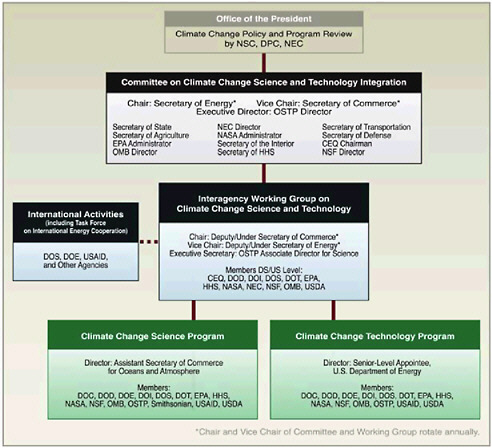
FIGURE 3.3. Organizational context for the Climate Change Science Program. SOURCE: CCSP (2003).
In addition to CCSP, which clearly has some current public attention through ongoing climate change discussions, ASP participates in 11 other domestic interagency organizations (Table 3.3) and numerous national subcommittees and task forces. Representation in these groups may be either through a representative of the ASP or through the Earth Science Division or other unit within NASA. As of August 2006 ASP was also involved in 10 international committees or working groups, including the Intergovernmental Panel on Climate Change, the World Meteorological Organization, the United Nations Educational, Scientific and Cultural Organization, and the Central American Commission for Environment and Development. The committee recognizes the relevance of these organizations and ASP’s effort to participate in their activities. However, similar to CCSP, determining the direct involvement of ASP in the organizations’ activities as opposed, or in addition, to the involvement of NASA generally was difficult either through public references for these organizations or through NASA’s and ASP’s web pages.
Table 3.3 Domestic Interagency Organizations in which ASP Participated in 2006
|
Organization |
Participants |
Focus |
|
Climate Change Science Program |
Federal agencies |
Climate change |
|
Climate Change Technology Program |
Federal agencies |
Energy Research and Development Portfolios |
|
United States Group on Earth Observations |
Federal agencies |
Earth observation systems |
|
Commercial Remote Sensing Space Policy |
Federal agencies |
Commercial remote sensing |
|
ederal Geographic Data Committee |
Federal agencies, state agencies |
Standards for geospatial data |
|
Geospatial One Stop |
Federal agencies |
Portals for geospatial data |
|
U.S. Weather Research Program |
Federal agencies |
Weather research |
|
Committee on Environment and Natural Resources Subcommittees |
Federal agencies |
Coordination of interagency science and technology programs |
|
Civil Applications Committee |
Civil agencies; intelligence community |
Coordination of Civil agency use of national assets |
|
Joint Planning and Development Office |
Federal agencies |
Aviation issues |
|
Ocean US |
Federal agencies |
Coordination of Oceans Research and Resources |
|
Subcommittee on Integrated Management of Ocean Resources |
Federal agencies |
Coordination of Management of Ocean Resources |
|
SOURCE: ASP (2006). |
||
SUMMARY
The ASP has focused on supporting other federal agencies as the primary method of reaching operational and resource management users. ASP has identified some specific successes in achieving societal benefits through transfer of NASA products to external applications and these include: (1) improved warning, monitoring, and recovery support from national disasters, such as hurricanes and floods; (2) more timely detection of tropical storms, resulting in much improved evacuation decisions; (3) improved wildfire detection; and (4) improvements in El Niño forecasting for the planning and protection of crops. The successful outcomes of use of NASA data in these types of projects are not solely attributable to ASP’s activities in facilitating partnerships, as many pro-
jects have had their genesis in other units within NASA where partnerships with external users were already established. The committee was challenged by the need to try to differentiate between what ASP could consider “their” successes and those successes that had input from other NASA units. The suggestion is therefore made that the requirement to document “successes” as measures of performance should be viewed and used as a means to encourage communication within NASA and not to obscure the intended collaborative nature of the relationship ASP has with its internal NASA colleagues, or the intended external partnerships between NASA and user communities.
While successful transfers of research to operation and DSS are documented, the committee identified room for improvement. In particular, the committee concludes that:
-
The lack of formal processes to establish requirements, coordinate activities, and make the transition from NASA research to partner operations affects ASP’s overall effectiveness.
-
Federal partners have received a broad range of attention and support from ASP. NOAA and agencies in DoD have committed dedicated personnel resources to ensure they receive NASA priority support. Others, such as USDA and EPA, have generated specific programs that help focus NASA efforts to solve their problems. Yet others, such as DHS, have a relatively passive relationship in which they have been simply recipients of NASA data. As an area in which to concentrate federal partnership development with “younger” agencies, disaster and risk management, in particular, may be one of the most obvious to provide direct and immediate societal benefit through application of remotely sensed data.
NASA’s relationship with NOAA is the most mature with respect to weather research and prediction applications but there is much room for improvement in the research-to-operations transition process.
-
A systematic feedback mechanism from end users to NASA program planners and decision makers is lacking. Many federal partners have expressed a requirement for high-resolution multispectral satellite data, for example, but indicate that they do not find an effective mechanism at NASA to absorb this feedback. In general, federal users have a wide range of needs in terms of satellite data continuity, quality, format, and resolution. They often adapt to data formats provided by NASA, but express that they have limited or no influence over data characteristics (see also Chapter 5, section 5.1.2).
The committee concludes that the most successful federal partnerships could include an explicit link to the partner federal agency’s user community and a plan for continuation after ASP funding ended.


