Appendix C
Mitigation Approaches Presented by NASA and NOAA at the Workshop
Mitigation Approaches to Address Impacts of NPOESS Nunn-McCurdy Certification on Joint NASA-NOAA Climate Goals
Joint NASA-NOAA Draft Study for OSTP (Phase II) June 19, 2007
Executive Summary [p. 2]
-
OSTP requested NOAA and NASA to provide:
-
An analysis of possible mitigation options of the climate impacts of the NPOESS Nunn-McCurdy Certification through 2026
-
An assessment of the potential costs of these options
-
-
Primary goal: Ensure continuity of long-term climate records
-
NOAA and NASA analyzed the following options:
-
Remanifesting the climate sensors on NPOESS spacecraft
-
Placing sensors on currently planned non-NPOESS spacecraft
-
Developing new gap-filling climate satellite missions
-
Partnering opportunities
-
-
Key results:
-
Work in progress: still assessing options
-
Multiple options exist to mitigate the loss of sensors from NPOESS
-
Options consistent with Decadal Survey recommendations
-
Partnering for altimetry could provide significant cost savings
-
NOTE: B. Cramer, NASA Headquarters, “Mitigation Approaches to Address Impacts of NPOESS Nunn-McCurdy Certification on Joint NASA-NOAA Climate Goals. Joint NASA-NOAA Draft Study for OSTP (Phase II),” presentation to the Options to Ensure the Climate Record from the NPOESS and GOES-R Spacecraft Workshop, June 19, 2007, available at http://www7.nationalacademies.org/ssb/SSB_NPOESS2007_Presentations.html. The presentation as delivered at the workshop has been reformatted somewhat for publication. Page numbers in brackets refer to the original presentation. All information presented is pre-decisional, and assessments involve preliminary rough-order-of-magnitude cost estimates only.
Climate Sensor Impact Assessment (summarized from January 2007 NASA/NOAA Joint Assessment) [pp. 3-4]
-
Total Solar Irradiance Sensor (TSIS)
-
Essential to discriminate between natural and anthropogenic causes of climate change
-
Would continue 25+ year long data record
-
-
Earth Radiation Budget Sensor (ERBS)
-
Continuously monitors the Earth’s radiation budget to identify subtle long-term shifts related to climate change
-
Would continue 21+ year long data record
-
-
Ocean Altimeter (ALT)
-
Monitors sea level
-
Would continue 15+ year long data record
-
-
Ozone Mapping and Profiler Suite (OMPS) – Limb Subsystem
-
Measures the vertical distribution of stratospheric ozone to monitor and understand the ozone recovery resulting from the Montreal Protocol
-
Would continue 23+ year long data record
-
-
Aerosol Polarimetry Sensor (APS)
-
Measures the global distribution of aerosols and their impact on the Earth’s energy balance, clouds, and precipitation
-
-
Conical Scanning Microwave Imager (CMIS) – Reduced Capability
-
Provides sea surface temperatures, sea ice and snow cover extents, soil moisture, ocean surface wind speed, water vapor, and precipitation rates even in the presence of heavy cloud cover
-
Continuous records date back to 1987
-
-
Visible Infrared Imaging Radiometer Suite (VIIRS) – Reduced Coverage (Absent from 0930 Orbit)
-
Multi-spectral imagers sample the spectral signatures of features on or near the Earth’s surface important to climate science
-
For over three decades, scientists have depended on this imagery for a wide variety of weather and climate applications
-
-
Cross-track Infrared Sounder (CrIS)/Advanced Technology Microwave Sounder (ATMS) – Reduced Coverage (Absent from 0530 Orbit)
-
No mitigation recommended for climate science
-
-
Space Environment Sensor Suite (SESS)
-
Not considered here
-
Development of Mitigation Options [p. 5]
-
Multiple options exist to mitigate the loss of sensors from NPOESS
-
Developed options using following criteria:
-
Minimize risk to measurement continuity
-
First priority for existing climate data records
-
-
Minimize risk to existing programs
-
Cost effectiveness
-
Economies of scale
-
Leverage planned missions and sensors including partnerships with other space agencies
-
-
Potential Mitigation Options [p. 6]
-
Option 1: NPOESS + Gap Filler Climate Satellite
-
Option 2: Sequential Climate Satellites
-
Option 3: Sequential Climate Satellites w/TSIS Redundancy
-
Option 4: Sequential Climate Satellites w/TSIS Redundancy & Operational Risk Reduction
-
These options also include free-flyer altimetry missions and climate data record science support
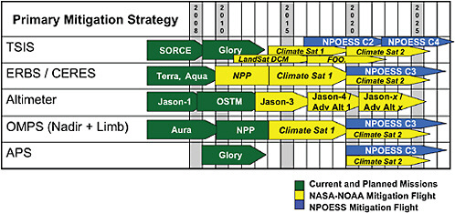
FIGURE [C.1] Range of Options Examined for Climate Data Continuity. [p. 7]
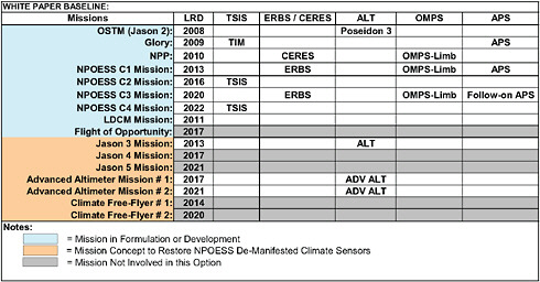
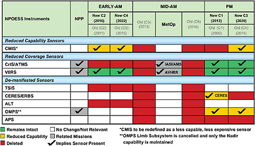
FIGURE [C.2] Initial Recommendation from January 2007 Joint Assessment. [p. 8]
NOTES:
• VIIRS flies on NPP, C1, C2, C3, and C4
• AVHRR flies on METOP mid-morning orbit
• CMIS to be replaced by MIS starting with C2
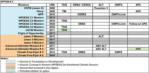
FIGURE [C.3] Option 1. NPOESS + Climate Satellite. [p. 9]
NOTES:
• The manifest for C1 is frozen based on technical risk considerations
• VIIRS flies on NPP, C1, C2, C3, and C4
• AVHRR flies on METOP mid-morning orbit
• CMIS to be replaced by MIS starting with C2
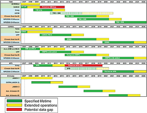
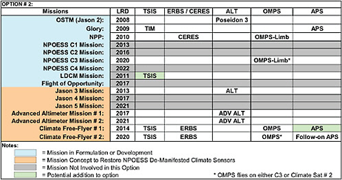
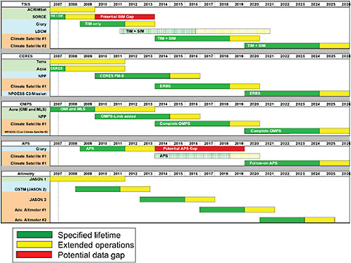
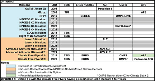
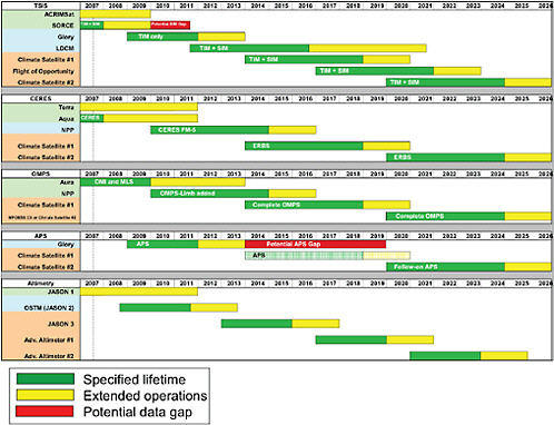
FIGURE [C.8] Option 3 and 4. Continuity Timeline. Sequential Climate Satellites + TSIS Redundancy. [p. 14]
Current Studies [p. 15]
-
Work in progress: still exploring options
-
NPOESS remanifest
-
Assessed 2 options for earliest return to NPOESS flights (C2-C4)
-
NASA procures and delivers sensors to NPOESS as Government Furnished Equipment (GFE)
-
The Integrated Program Office (IPO) procures sensors via current prime contractor overseeing subcontracted instrument vendors
-
-
-
Altimetry
-
Altimetry capability explored as free-flying Jason follow-on and as advanced altimeter missions
-
-
Climate satellite missions
-
Examined 2 research-grade missions
-
Additionally explored TSIS (total and spectral) on Landsat Data Continuity Mission (LDCM) and International Space Station (ISS)
-
Currently assessing CERES on NPP
-
-
-
Examined 2 operational-grade missions
-
Used sensor analysis from NASA plus spacecraft development analysis from NOAA Polar Extended Mission study (2006)
-
Climate Data Record (CDR) Science Support [p. 16]
-
Includes development, production, reprocessing, stewardship, and distribution
-
Assumes data from all NPOESS certified sensors and mitigation sensors / sources
-
Covers about 30 Climate Change Science Program essential climate variables
-
Will be covered in more detail in following presentation
Free Flyer Climate Satellite [p. 17]
-
Would fly in formation with NPOESS PM to provide imager data
-
Two options were examined:
-
Research spacecraft
-
Planned 5-year mission
-
Single string development with selective redundancy
-
Inexpensive, non-standard launch vehicle
-
Ground segment leverages existing systems.
-
-
Operational spacecraft
-
Planned 7-year mission with additional redundancy
-
Standard launch vehicle
-
Additional investment in ground segment
-
-
-
Current cost estimate range for a 3-sensor satellite is approximately $700M-$1100M
-
CDR Science Support is an additional $300M-$450M
-
Altimetry Options [p. 18]
-
NPOESS sun-synchronous orbits are NOT ideal for precision altimetry
-
Flight of an altimeter on NPOESS is NOT recommended
-
For this analysis, “free flyer” satellites in the NOAA / EUMETSAT JASON series are assumed
-
Three satellites beyond JASON 2 required to provide coverage to 2026
-
Costs estimated for JASON 3, 4, and 5
-
Advanced altimeter costs also estimated
-
May replace JASON class missions starting with JASON 4
-
-
-
Independent of this study, U.S. Navy is working with the IPO to develop costs and options to procure an operational oceanography radar altimeter
-
Current total cost estimate for a series of 3 missions ranges from approximately $1.5B-$2.1B
-
CDR Science Support is an additional ~$200M
-
Current cost estimate for a single JASON follow-on is approximately $470M with the potential for 50/50 cost sharing with partners
-
TABLE Climate Goal Partnering Opportunities (Preliminary) [p. 19]
|
|
Partner |
Sensor or Capability |
Timeframe |
Role |
|
Increasing Potential → |
EUMETSAT |
Jason-3 |
2013-2018 |
Mitigate |
|
NASA/Navy |
Adv. Altimeter |
TBD |
Mitigate |
|
|
ESA/JAXA (Earthcare) |
APS/ERBS-like |
2010-20xx |
Mitigate |
|
|
ESA GMES Sentinel 3 |
Altimeter |
|
Complement |
|
|
Navy (NPOESS) |
Altimeter (Op) |
2016-2026 |
Complement |
|
|
Navy (DoD Space Test Program) |
Altimeter (Op) |
|
Complement |
|
|
CNES Megha-Tropiques |
ERBS-like |
|
Complement |
|
|
Chinese SOA (HY series) |
Altimeter |
|
Mitigate |
|
|
Brazilian Space Agency (Amazonia) |
Flight Opportunity |
2010/2015 |
Accommodation |
|
|
EUMETSAT (MSG) |
ERBS-like |
on-orbit |
Complement |
|
|
Chinese Met. Agency (FY series) |
ERBS-like |
|
Mitigate |
|
|
ESA PARASOL |
APS-like |
on-orbit |
Complement |
Related Concerns [p.20 ]
-
VIIRS
-
Reduced imaging capability for mid-morning orbit
-
Discussions on-going with EUMETSAT about an advanced imager on METOP-D
-
-
Optical Crosstalk
-
-
MIS
-
Reduced capability microwave imager
-
First MIS scheduled to fly on NPOESS C2 (2016)
-
Discussion on-going with JAXA about AMSR-2
-
Pursuing several options for continuity of ocean vector wind measurements
-
TABLE Near-Term Planning [p.21 ]
|
|
Decision/Funding Commitment |
Launch Readiness Date |
|
CERES on NPP |
September 2007 / FY07* |
September 2009 |
|
TSIS on LDCM |
January 2008 / FY09 |
Late 2011 |
|
JASON-3 |
Decision CY08 / FY10 |
2013 |
|
First Climate Free-Flyer |
Mid 2009 / Pre-Phase A FY08 |
2014 |
|
* Would require re-allocation of existing funds |
||
Next Steps [p.22 ]
-
Listen closely to the input from this Workshop
-
Continue to work with OSTP
-
Continue dialogue regarding potential international and/or domestic partnerships