
APPENDIX J
Response to the Chilean-Earthquake Generated Tsunami: The Hawaii Case Study
EVENT TIMELINE
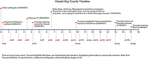
On Friday, February 26, 2010, at 20:34:14 Hawaii Standard Time (HST) (Saturday, February 27, 2010, at 06:34:14Z; Figure J.1) a magnitude 8.8 earthquake occurred offshore of Maule, Chile, in position 35.909ºS, 72.733ºW, approximately 35 km below the surface of the earth.1 The Pacific Tsunami Warning Center (PTWC) transmitted its first tsunami information message to the Civil Defense in the State of Hawaii (see Figure J.2) 15 minutes after the earthquake at 20:49 HST (February 27 at 06:49Z)2 and issued its first tsunami warning bulletin to the Intergovernmental Oceanographic Commission (IOC) at 20:46 HST (February 27 at 06:46Z). The West Coast/Alaska Tsunami Warning Center (WC/ATWC) issued its first tsunami information statement at 20:49 HST (February 27 at 06:49Z). The first tsunami waves arrived at Valparaiso, Chile, approximately 34 minutes after the initial earthquake.3
Around 06:00 HST (16:35Z) on February 27, evacuation alarms were sounded in low-lying counties in Hawaii. The first waves reached Hawaii shortly after 11:35 HST (21:35Z), approximately 14.5 hours after the initial earthquake. Life in Hawaii started to return to normal at approximately 14:00 HST (February 28, 00:35Z) when the tsunami warning was lifted.
DESCRIPTION OF TSUNAMI WARNING CENTER MESSAGES TRANSMITTED TO CIVIL DEFENSE IN THE STATE OF HAWAII2
The PTWC transmitted its first tsunami message to Civil Defense in Hawaii at 20:49 HST on February 26. The message introduced a tsunami advisory, stated that the PTWC had issued an “expanding regional tsunami warning and watch for parts of the Pacific located closer to the earthquake” and advised that the earliest arrival of any tsunami wave would be 11:19 HST on February 27. Updated messages were released approximately every hour. Measurements and reports of tsunami wave activity were introduced in Message 3 and were continually updated through Message 20.
Message 6 issued a tsunami warning at 00:46 HST (approximately 11.5 hours before the forecast arrival of the tsunami). Message 12 (Box J.1) introduced the first forecasts of combined wave arrival times and amplitudes (crest to trough) for Hawaii. No additional forecasts were provided in Messages 13-16. Updated forecasts were provided in Message 17. Message 18 reported the arrival of the tsunami in Hawaii. Message 20 canceled the tsunami warning and was the final message issued for the tsunami generated by the Chilean earthquake.
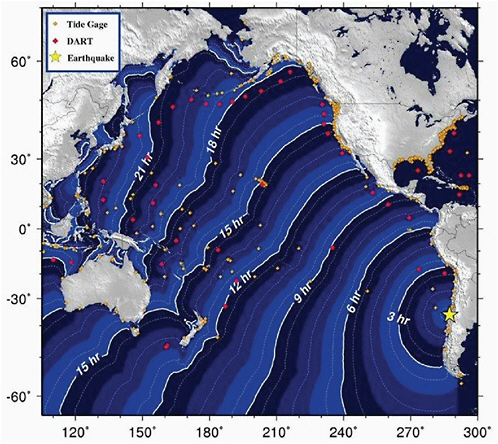
FIGURE J.1 Travel times for the February 27, 2010, Chilean tsunami. SOURCE: http://wcatwc.arh.noaa.gov/previous.events/Chile_02-27-10/Images/traveltime.jpg; West Coast/Alaska Tsunami Warning Center, NOAA.
DECISIONS MADE IN HAWAII
A statewide evacuation was not ordered; evacuation decisions were left to local counties.4 On September 27, the Oahu Emergency Management Department spokesman was quoted at 03:51 HST in the Honolulu Advertiser as saying, “If you live anywhere in the evacuation zone, you have to evacuate. This is a serious event. We’re going to treat this as a destructive-type tsunami” (Box J.2). The Department of Emergency Management issued a Tsunami Evacuation Information notice (no time stamp available) notifying residences in the coastal tsunami evacuation zones on Oahu that they should begin evacuation immediately at 06:00 HST when
|
BOX J.1 BULLETIN TSUNAMI MESSAGE NUMBER 12 NWS PACIFIC TSUNAMI WARNING CENTER EWA BEACH HI 624 AM HST SAT FEB 27 2010 TO - CIVIL DEFENSE IN THE STATE OF HAWAII SUBJECT - TSUNAMI WARNING SUPPLEMENT A TSUNAMI WARNING CONTINUES IN EFFECT FOR THE STATE OF HAWAII. AN EARTHQUAKE HAS OCCURRED WITH THESE PRELIMINARY PARAMETERS ORIGIN TIME - 0834 PM HST 26 FEB 2010 COORDINATES - 36.1 SOUTH 72.6 WEST LOCATION - NEAR COAST OF CENTRAL CHILE MAGNITUDE - 8.8 MOMENT MEASUREMENTS OR REPORTS OF TSUNAMI WAVE ACTIVITY GAUGE LOCATION LAT LON TIME AMPL PER ------------------- ----- ------ ----- --------------- ---- RIKITEA PF 23.1S 134.9W 1536Z 0.16M / 0.5FT 48MIN DART MARQUESAS 5140 8.5S 125.0W 1531Z 0.18M / 0.6FT 18MIN QUEPOS CR 0.0N 9.4E 1416Z 0.24M / 0.8FT 52MIN BALTRA GALAPAGS EC 0.4S 90.3W 1452Z 0.35M / 1.2FT 14MIN EASTER CL 27.2S 109.5W 1205Z 0.35M / 1.1FT 52MIN ANCUD CL 41.9S 73.8W 0838Z 0.62M / 2.0FT 84MIN CALLAO LA-PUNTA PE 12.1S 77.2W 1029Z 0.36M / 1.2FT 30MIN ARICA CL 18.5S 70.3W 1008Z 0.94M / 3.1FT 42MIN IQUIQUE CL 20.2S 70.1W 0907Z 0.28M / 0.9FT 68MIN ANTOFAGASTA CL 23.2S 70.4W 0941Z 0.49M / 1.6FT 52MIN DART LIMA 32412 18.0S 86.4W 0941Z 0.24M / 0.8FT 36MIN CALDERA CL 27.1S 70.8W 0843Z 0.45M / 1.5FT 20MIN TALCAHUANO CL 36.7S 73.4W 0653Z 2.34M / 7.7FT 88MIN COQUIMBO CL 30.0S 71.3W 0852Z 1.32M / 4.3FT 30MIN CORRAL CL 39.9S 73.4W 0739Z 0.90M / 2.9FT 16MIN SAN FELIX CL 26.3S 80.1W 0815Z 0.53M / 1.7FT 08MIN VALPARAISO CL 33.0S 71.6W 0708Z 1.29M / 4.2FT 20MIN |
|
LAT - LATITUDE (N-NORTH, S-SOUTH) LON - LONGITUDE (E-EAST, W-WEST) TIME - TIME OF THE MEASUREMENT (Z IS UTC IS GREENWICH TIME) AMPL - TSUNAMI AMPLITUDE MEASURED RELATIVE TO NORMAL SEA LEVEL. IT IS …NOT… CREST-TO-TROUGH WAVE HEIGHT. VALUES ARE GIVEN IN BOTH METERS(M) AND FEET(FT). PER - PERIOD OF TIME IN MINUTES(MIN) FROM ONE WAVE TO THE NEXT. EVALUATION A TSUNAMI HAS BEEN GENERATED THAT COULD CAUSE DAMAGE ALONG COASTLINES OF ALL ISLANDS IN THE STATE OF HAWAII. URGENT ACTION SHOULD BE TAKEN TO PROTECT LIVES AND PROPERTY. A TSUNAMI IS A SERIES OF LONG OCEAN WAVES. EACH INDIVIDUAL WAVE CREST CAN LAST 5 TO 15 MINUTES OR MORE AND EXTENSIVELY FLOOD COASTAL AREAS. THE DANGER CAN CONTINUE FOR MANY HOURS AFTER THE INITIAL WAVE AS SUBSEQUENT WAVES ARRIVE. TSUNAMI WAVE HEIGHTS CANNOT BE PREDICTED AND THE FIRST WAVE MAY NOT BE THE LARGEST. TSUNAMI WAVES EFFICIENTLY WRAP AROUND ISLANDS. ALL SHORES ARE AT RISK NO MATTER WHICH DIRECTION THEY FACE. THE TROUGH OF A TSUNAMI WAVE MAY TEMPORARILY EXPOSE THE SEAFLOOR BUT THE AREA WILL QUICKLY FLOOD AGAIN. EXTREMELY STRONG AND UNUSUAL NEARSHORE CURRENTS CAN ACCOMPANY A TSUNAMI. DEBRIS PICKED UP AND CARRIED BY A TSUNAMI AMPLIFIES ITS DESTRUCTIVE POWER. SIMULTANEOUS HIGH TIDES OR HIGH SURF CAN SIGNIFICANTLY INCREASE THE TSUNAMI HAZARD. THE ESTIMATED ARRIVAL TIME IN HAWAII OF THE FIRST TSUNAMI WAVE IS 1119 AM HST SAT 27 FEB 2010 FORECAST WAVE ARRIVAL TIMES AND AMPLITUDES CREST TO TROUGH. HILO 1105AM HST 2.5 METERS HONOLULU 1137AM HST 0.5 METERS KAHULUI 1126AM HST 2.2 METERS NAWILIWILI 1142AM HST 0.9 METERS HALEIWA 0.5 METERS KAWAIHAE 0.6 METERS THESE ARE ONLY ESTIMATES…ACTUAL VALUES MAY DIFFER. MESSAGES WILL BE ISSUED HOURLY OR SOONER AS CONDITIONS WARRANT. |
outdoor warning sirens sounded. Residents not located in evacuation zones were instructed to stay off the roads so that they would be open for evacuees and first responders.5 Similar messages were released by Kauai Civil Defense.6 Roads and businesses in low-lying areas throughout Hawaii were closed through the morning. Low-lying county facilities, including sewage treatment plants and wastewater pump facilities on Oahu and Maui, were closed, later resulting in sewage spills.7 Private boats and commercial and military vessels evacuated Hawaiian harbors for deeper water.4 Media sources and residents reported long lines at gas stations and at supermarkets where customers sought water, batteries, generators, and food supplies. Many of these supplies were later returned to the supermarkets.4
SUMMARY OF LESSONS LEARNED
Wave Height Forecasts by Tsunami Warning Centers
Availability of Deep-ocean Assessment and Reporting of Tsunamis (DART) buoy data from a buoy near Peru allowed for near-real-time forecasting of the wave heights relatively soon after the initial earthquake. The committee believes that PTWC chose to forecast wave heights using a model developed in-house (Table J.1).
Education of Officials/Citizens
Reports from this event suggest that responsible officials and citizen understanding of tsunamis is insufficient. Specifically, there was a lack of understanding of the different nature of a tsunami wave, which is similar to a massively high tide that cycles on the order of minutes or several hours rather than a common breaking wave, and the potential for strong local currents after the initial waves had passed. One public safety official was quoted as saying that extensive preparations were occurring in Hilo, which was directly exposed to the tsunami, whereas parts of Hawaii that are sheltered by the Big Island would take the brunt of its force.8 This is untrue; tsunamis can wrap efficiently around islands, and local hydrographic features can significantly magnify the effects of a tsunami (as is the case in Hilo Bay, Hawaii).
It was apparently unclear to many citizens where, beyond higher ground, they should evacuate to. Evacuation shelters were opened in some locations. Others remained closed because they were intended only to shelter displaced residents after a natural disaster, not temporary evacuees.9 Residents formed long lines at supermarkets to stock up on emergency supplies, many of which were subsequently returned after the tsunami warning was lifted. This indicates an ongoing reluctance of citizens to heed advice to be prepared for emergencies by stocking up in advance.
TABLE J.1 Tsunami Wave Height—Forecast and Observed
|
Tsunami Wave Height—Forecast and Observed |
|||
|
PWTC Forecast “Crest to Trough”a |
PWTC Observed Wave Amplitudesb |
||
|
0624 HST Forecast2 |
1338 PTWC Message2 |
||
|
Hilo |
2.5m |
Hilo |
~1m1 |
|
Kahalui |
2.2 |
Kahalui |
0.98m |
|
Nawiliwili |
0.9m |
Nawiliwili |
0.28m |
|
Haleiwa |
0.5m |
|
|
|
Kawaihae |
0.6m |
Kawaihae |
0.52m |
|
|
|
Barbers Pt |
0.19m |
|
|
|
Kaumalapau |
0.18m |
|
|
|
1Media Reported PTWC Value |
|
|
1025 HST Forecast2 |
|
|
|
|
Hilo |
2.1-2.5m |
|
|
|
Honolulu |
0.5-0.7m |
|
|
|
Kahului |
1.1-3.0m |
|
|
|
Nawiliwili |
0.9-1.4m |
|
|
|
Haleiwia |
0.5-1.1m |
|
|
|
Kawaihae |
0.6-1.6m |
|
|
|
a Reported as “Amplitudes Crest to Trough.” b Amplitudes reported relative to normal sea level (approximately one-half of wave height or “amplitude measured crest to trough”). SOURCE: Committee staff. |
|||
Response by Decision Makers
The first evidence of evacuation recommendations appears in a 03:51 HST newspaper article in the form of a quote from the spokesman for the Oahu Emergency Management Department (“If you live anywhere in the evacuation zone, you have to evacuate. This is a serious event. We’re going to treat this as a destructive-type tsunami;” Box J.2); an official release from the Department of Emergency Management provided additional evacuation information. The official release did not contain a time/date stamp, but refers to the 06:00 HST activation of the evacuation sirens in the future tense, indicating that it was released prior to the siren activation.6 This suggests that the decision to evacuate low-lying areas was made after a tsunami warning was announced at 00:46 HST, but before the first wave amplitudes (crest to trough) forecasts were received at 06:24 HST.
Actions taken by local officials have been praised, but also criticized as excessive in light of observed tsunami activity. At this time, it is still unclear what information led officials to order the evacuation of low-lying areas and undertake other preparatory measures such as securing power to sewage treatment plants and associated infrastructure.
|
BOX J.2 Updated at 3:51 a.m., Saturday, February 27, 2010 Residents along shorelines told to evacuate in advance of waves Advertiser Staff Oahu officials are urging anyone who lives in a tsunami inundation zone to evacuate in advance of the waves hitting just after 11 a.m. today. Warning sirens will start sounding at 6 a.m. “If you live anywhere in the evacuation zone, you have to evacuate,” said John Cummings, Oahu Emergency Management Department spokesman. “This is a serious event. We’re going to treat this as a destructive-type tsunami.” The last time there were voluntary tsunami evacuations in Hawaii was in 1994. Cummings said getting out of the inundation zone could be as simple as crossing the street or walking to higher ground. He and others urged people to stay off the roads as much as possible. After the warning sirens sound this morning, first responders and Civil Defense volunteers will start going door-to-door in coastal areas to tell people to evacuate. Cummings also said that there will be city buses going up and down shoreline areas picking up anyone who needs to get out of the inundation zone. The ride will be free and the special city buses will say “evacuation,” Cummings said. The buses will take people to safe areas where they can wait out the waves. People in need of the ride can flag down the buses, and don’t have to wait at bus stops, he said. The tsunami expected to hit just after 11 a.m. will likely create the biggest problems in enclosed bay areas, including Hilo, Kahului, Haleiwa, where the waves could reach six to eight feet, officials said. Along other shorelines, the waves are expected to be less than three feet, said Pacific Tsunami Warning Center geophysicist Brian Shiro. He said the warning sirens that will go off at 6 a. m. and sound regularly as the tsunami gets closer mean that residents in tsunami inundation zones should evacuate. He said people should not get in their cars to evacuate, but should walk to higher ground. “All of our predictions and models are suggesting the tsunami in Hawaii is going to be less than three feet. That’s not huge,” he said. “But in places like Hilo Bay, Kahului, Haleiwa, the tsunami is going to probably get trapped and … be as high as 6 to 8 feet.” He urged people to stay away from the water. SOURCE: Honolulu Advertiser. 2010. Residents Along Shorelines Told to Evacuate in Advance of Waves. [Online]. Available: http://the.honoluluadvertiser.com/article/2010/Feb/27/br/hawaii100227012.html [2010, June 29]. |
Findings
-
The decisions to order evacuations at the county level on Oahua and Kauai apparently preceded transmission of the first tsunami “amplitude (crest to trough)” model results.
-
The Tsunami Warning Centers provided forecasts to Civil Defense in the state of Hawaii that proved to be within the range of observed conditions.
REFERENCES
1. U.S. Geological Survey. 2010. Magnitude 8.8–Offshore Bio-Bio, Chile 2010 February 27 06:34:14 UTC. [Online]. Available: http://earthquake.usgs.gov/earthquakes/recenteqsww/Quakes/us2010tfan.php [2010, June 29].
2. National Oceanic and Atmospheric Administration. 2010. Index of PTWC Messages Hawaii 2010. [Online]. Available: http://www.prh.noaa.gov/ptwc/messages/hawaii/2010/ [2010, June 29].
3. National Oceanic and Atmospheric Administration. 2010. Tsunami Event—February 27, 2010 Chile Main Event Page. [Online]. Available: http://nctr.pmel.noaa.gov/chile20100227/ [2010, June 29].
4. New York Times. 2010. Hawaii Exhales as Tsunami Warning Is Canceled. [Online]. Available: http://www.nytimes.com/2010/02/28/us/28warning.html [2010, June 29].
5. City and County of Honolulu. 2010. Department of Emergency Management Issues Tsunami Evacuation Information. [Online]. Available: http://www.honolulu.gov/csd/publiccom/honnews10/DEMTsunamiEvacuation.htm [2010, June 29].
6. County of Kauai State of Hawaii. 2010. Civil Defense Program Description. [Online]. Available: http://www.kauai.gov/Government/Departments/CivilDefenseAgency/tabid/90/Default.aspx [2010, June 29].
7. Honolulu Star Bulletin. 2010. Tsunami Response Flaws Draw Review. [Online]. Available: http://www.starbulletin.com/news/20100228_Tsunami_response_flaws_draw_review.html [2010, June 29].
8. The Wall Street Journal. 2010. Hawaii Unaffected by Tsunami. [Online]. Available: http://online.wsj.com/article/SB10001424052748704231304575091624043844744.html [2010, June 29].
9. The Maui News. 2010. Officials Assess Tsunami Response. [Online]. Available:http://www.mauinews.com/page/content.detail/id/529308.html


