
CHAPTER ONE
Introduction
THE TSUNAMI THREAT IN THE UNITED STATES
The 2004 Indian Ocean tsunami resulted in catastrophic losses of life and property and demonstrated how destructive tsunamis can be. More than 200,000 people died, with most occurring in Indonesia, which was near the tsunami source, but deaths were also reported in countries as far away as Somalia. Recently, the Samoan (September 2009) and Chilean (February 2010) tsunamis reminded the world of how quickly a tsunami can move onshore and destroy lives. In comparison to extreme weather—such as floods, hurricanes, or tornadoes—tsunamis have caused comparatively few fatalities in the United States over the past 200 years. Modern records kept since 1800 tally less than 800 lives lost due to tsunamis in the United States and territories.1 In 1960, a magnitude 9.5 Chilean earthquake generated tsunami waves that killed 61 people and caused $24 million in property damage in Hilo, Hawaii (Eaton et al., 1961). The 1964 Good Friday earthquake in Alaska generated a tsunami that devastated local Alaskan communities and inundated distant communities as far south as Crescent City, California.
Earlier tsunamis—yet to be repeated in modern times—include tsunami waves of North American origin in the year 1700 that caused flooding and damage as far away as Japan. Paleo-records indicate that the Cascadia subduction zone off the Washington, Oregon, and northern California coasts has repeatedly generated potentially catastrophic tsunamis (Atwater et al., 2005). Because of the relative infrequency of catastrophic tsunamis in recent U.S. history, mobilizing the required resources to maintain the nation’s warning and preparedness capabilities is challenging.
Tsunamis are caused by a variety of geological processes, such as earthquakes, subaerial and submarine landslides, volcanic eruptions, or very rarely from meteorite impacts (Box 1.1). However, it takes a large event (e.g., typically an earthquake of magnitude greater than 7.0) to generate a damaging tsunami. Therefore, determining the likelihood of future tsunamis for U.S. coastal communities requires an understanding of the likelihood of reoccurrence of such geological processes, the likely magnitude of such events, and the location of the sources (see Chapter 3 for additional details). Because most tsunamis result from earthquakes, the tsunami hazard is high along U.S. shores that adjoin boundaries between tectonic plates, particularly along the subduction zones of Alaska, the Pacific Northwest, the Caribbean, and the Marianas (Figure 1.1). However, U.S. shores are also exposed to tsunamis generated far from them. For example, Hawaii has been struck by tsunamis that have been generated by earthquakes off the coasts of South America, Russia, and Alaska (Cox and Mink, 1963). Submarine landslides,
|
BOX 1.1 What Is a Tsunami? A tsunami is a series of waves generated by an impulsive disturbance in a body of water such as a lake or ocean. The disturbance is typically a fault displacement. Less commonly, the displacement results from a landslide (into or below the water surface), volcanic activity, or rarely from a meteorite impact. It typically takes a large earthquake (magnitude >7.0) to generate a damaging tsunami in the near-field and a great earthquake (magnitude >8.0) to generate a tsunami in the far-field. The height of a tsunami ranges from centimeters to more than tens of meters and depends on the initial disturbance and the bathymetry of the seafloor over which the waves travel. The waves are very small in deep water, but grow in height once they move into shallow water. The velocity at which the tsunami travels away from the source depends on the water depth. A tsunami in deep water (≥4 km) is about as fast as a jetliner (700-800 km/hr) and slows to the speed of a car (60 km/hr) in shallow water. For example, a tsunami originating in the central Aleutian Islands near Alaska would arrive on the Hawaiian shores in about five hours. Such tsunamis, originating far from where it runs ashore, are commonly referred to as “far-field” tsunamis, which allow at-risk communities several hours to evacuate if the warning is received promptly. However, a tsunami triggered by an event close to shore (e.g., an earthquake associated with the Cascadia subduction zone), would reach communities in low-lying coastal areas in a few minutes, allowing for little time to warn and evacuate. When the tsunami originates close to the at-risk community, it is termed a “near-field” tsunami. For the near-field tsunami, people need to recognize the triggering earthquake as their warning to evacuate. Tsunami arrival times can range from minutes to many hours. The report mainly discusses the near- and far-field tsunamis (at either extreme end of the arrival time range) because of the unique challenges they pose to the warning and preparedness efforts. However, a tsunami can be triggered by an earthquake that is only weakly felt onshore, yet may arrive in under an hour. Such events are also considered and mentioned because they heighten the challenges associated with preparing and warning the public. |
probably triggered by earthquakes, account for much of the known tsunami hazard along the U.S. Atlantic and Gulf coasts, and in southern California (Dunbar and Weaver, 2008). Seismically active faults and the potential for landslides in the Caribbean pose a significant tsunami risk for that region (Dunbar and Weaver, 2008).
Tsunami hazard zones of U.S. coastal communities contain thousands of residents, employees, and tourists, and represent significant economic components of these coastal communities (Wood, 2007; Wood et al., 2007; Wood and Soulard, 2008). The economic and social risks from tsunamis grow with increasing population density along the coasts. To reduce societal risks posed by tsunamis, the nation needs a clear understanding of the nature of the tsunami hazard (e.g., source, inundation area, speed of onset) and the societal characteristics of coastal communities (e.g., the number of people, buildings, infrastructure, and economic activities)
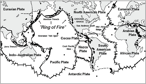
FIGURE 1.1 Global map of active volcanoes and plate tectonics illustrating the “Ring of Fire” and depicting subduction zones; both areas associated with frequent seismic activity. SOURCE: http://vulcan.wr.usgs.gov/Imgs/Gif/PlateTectonics/Maps/map_plate_tectonics_world_bw.gif; USGS.
that make them vulnerable to future tsunamis. With a clear understanding of the tsunami hazards and social vulnerability that comprise tsunami risk, officials and the general public can then prepare for future events and hopefully reduce this risk.2
When assessing tsunami hazard and developing risk reduction measures, it is important to consider the distance between a coastal community and potential tsunami sources as well as the probability of occurrence. Near-field tsunamis (see Box 1.1) pose a greater threat to human life than far-field tsunamis because of the short time between generation and flooding; because the extent of flooding is likely greater; and because the flooded area may be reeling from an earthquake (National Science and Technology Council, 2005). Near-field tsunamis account for most U.S. tsunami deaths outside of Hawaii, but even Hawaii has suffered losses from near-field tsunamis. Because it takes a very large earthquake to impact the far-field, more triggering events have the potential to impact communities that are within an hour or less from the source. For example, an earthquake generated within the Cascadia fault zone along the northern California, Oregon, and Washington coasts will allow only minutes for evacuation of
the coastal communities after the earthquake is felt. In addition, tsunami observations demonstrate an increase in wave height with proximity to the source, resulting in extensive coastal flooding by a near-field tsunami. Consequences of a near-field tsunami are far greater for any given location.
Far-field tsunamis afford hours of advance notice for evacuation and are likely to have smaller wave heights than those in the tsunami’s near field. However, the farther a coastal community from the earthquake source the less likely it is to have felt the earthquake and the more dependent it is on an instrumental detection system to provide warnings. Timely and accurate warnings are required to implement orderly evacuations and to avoid frequent unnecessary evacuations, which can be costly. The National Science and Technology Council (NSTC) report (2005) concludes that “the challenge is to design a tsunami hazard mitigation program to protect life and property from two very different types of tsunami events.”
GOALS AND SCOPE OF THIS REPORT
The 2004 Indian Ocean tsunami, spurred two congressional acts intended to reduce losses of life and property from future tsunamis. The Emergency Supplemental Appropriations Act for Defense, the Global War on Terror, and Tsunami Relief, 2005 (P.L. 109-13), included $24 million to improve tsunami warnings by expanding tsunami detection and earthquake monitoring capabilities. This Act was followed in 2006 by the Tsunami Warning and Education Act (P.L. 109-424), which directs the National Oceanic and Atmospheric Administration (NOAA) to strengthen the nation’s tsunami warning system (TWS), work with federal and state partners toward the mitigation of tsunami hazards, establish and maintain a tsunami research program, and assist with efforts to provide tsunami warnings and tsunami education overseas.
Section 4(j) of the Tsunami Warning and Education Act calls upon the National Academy of Sciences (NAS) “to review the tsunami detection, forecast, and warning program established under this Act to assess further modernization and coverage needs, as well as long-term operational reliability issues.” In response, NOAA asked the NAS to assess options to improve all aspects of the tsunami program. This request is reflected in the first part of the committee’s charge (see Appendix B) and accordingly focuses on efforts on tsunami detection, forecasting, and warning dissemination.
The NAS, in accepting this charge and in consultation with NOAA, broadened the review’s scope to include an assessment of progress toward additional preparedness efforts to reduce loss of life and property from tsunamis in the United States as part of the National Tsunami Hazard Mitigation Program (NTHMP). The main rationale for this broadened scope was to address Section 5(a) in P.L. 109-424, which called for “a community-based tsunami hazard mitigation program to improve tsunami preparedness of at-risk areas in the United States and its territories.” Such a tsunami hazard mitigation program requires partnership among federal, state, tribal, and local governments. Its strategies include identifying and defining tsunami hazards, making inventories of the people and property in tsunami hazard zones, and providing the public with knowledge and infrastructure for evacuation, particularly for near-field
tsunamis that come ashore in a few minutes. The broadened scope aims at encompassing the range of national tsunami warning and preparedness efforts.
The Range of Options Available for Tsunami Hazard Mitigation
As the scope of the study was broadened to include aspects of tsunami hazard mitigation, the committee recognized the need to define the term “mitigation” and set some boundaries for the study, because the full suite of mitigation options exceeds the purview and capacity of this particular study. The definition of hazard mitigation and the actions it includes differ among various hazard communities. Some members of the academic community consider the full range of hazard mitigation options to include three classes of actions (White and Haas, 1975): (1) modifying the natural causes of hazards, (2) modifying society’s vulnerability (e.g., levees, wind- and seismic-resistant houses), and (3) redistributing the losses that occur (e.g., insurance, emergency response). In contrast, natural hazard practitioners consider the range of human adjustment to natural hazards to fall into two major classes of actions: (1) mitigation of potential losses through interventions in the constructed world in ways that lessen potential losses from nature’s extremes (e.g., land-use management, control and protection works, building codes), and (2) preparedness for, response to, and recovery from specific events and their associated losses (Mileti, 1999).
Focus on Warning and Preparedness
Although land-use planning and adjusting building codes is important in mitigating the impacts of tsunamis, the charge to the committee is focused primarily on the detection, forecast, and warning for near- and far-field tsunamis and issues directly related to the effective implementation of those warnings. To be responsive to its charge, the report focuses on the second class of mitigation actions, which generally includes pre-event planning to develop preparedness plans, appropriate organizational arrangements, training and exercises for issuing event-specific public warnings, an adequate emergency response, and plans for recovery and reconstruction. These types of adjustment are based on the notion that the adequacy of pre-event planning determines the effectiveness of event-specific response. This view also places insurance in the preparedness class.
THE NATION’S TSUNAMI WARNING AND PREPAREDNESS EFFORTS
Only very recently has there been a national interest in tsunami warning and preparedness. Before 2004, most efforts were spearheaded by local, state, or regional initiative operating on very limited budgets. Integrating these existing individual efforts into a national tsunami program has led to a very different type of program than that of a national tsunami warning program designed from the outset. The history of tsunami warning and preparedness efforts can be traced back to two of the six destructive tsunamis that caused causalities on U.S. soil.
These efforts were originally part of the National Geodetic Survey, which developed the two tsunami warning centers (TWCs) in Hawaii and Alaska after the 1946 Aleutian tsunami (Unimak Island, AK) and the 1964 Alaskan tsunami (Prince William Sound, AK) (Figure 1.2). These centers eventually became part of NOAA’s National Weather Service (NWS), but each is located in different NWS regions and is managed independently.
Concern about tsunamis in Washington, Oregon, and California increased in the late 1980s and early 1990s when several new scientific studies revealed their near-field tsunami threat from the Cascadia subduction zone (Atwater, 1987; Heaton and Hartzell, 1987). California was reminded of its potential tsunami threat by an earthquake near Cape Mendocino in 1992, which generated a small tsunami that arrived in Eureka only minutes after the earthquake occurred. These and other developments prompted a more urgent call to produce comprehensive assessments of tsunami risk and preparedness at the state and federal level.
Congress responded to this call in a 1995 Senate Appropriations Committee request to NOAA to develop a plan for reducing tsunami risk to coastal communities. NOAA suggested the formation of a national committee to address tsunami threat, leading to the establishment of the NTHMP that same year. The NTHMP is tasked with coordinating the various federal, state, territorial, and commonwealth tsunami efforts. NOAA’s Tsunami Program was established in 2005 to incorporate all the current tsunami efforts at NOAA (see below). To respond to the committee’s charge (see Appendix B) and assess progress made toward improved tsunami warning and preparedness, the committee begins its evaluation with an inventory of the elements of the NTHMP and NOAA’s Tsunami Program.
National Tsunami Hazard Mitigation Program
The NTHMP has a Coordinating Committee (steering committee) that works to collaborate on the tsunami mitigation efforts of the NTHMP and three subcommittees: a Mapping and Modeling Subcommittee, a Warning Coordination Subcommittee, and a Mitigation and Education Subcommittee.3 In addition to coordinating individual efforts, the NTHMP provides guidance to NOAA’s TWSs. Federal partners include NOAA, the U.S. Geological Survey (USGS), and the Federal Emergency Management Agency (FEMA). State partners originally included Hawaii, Alaska, Washington, Oregon, and California, and now include all 29 U.S. coastal states and territories.
The USGS contributes to the seismic network that the TWCs use through operating and maintaining their respective seismic networks and to the tsunami research and risk assessments and conducts an independent seismic analysis of potential tsunamigenic earthquakes at its National Earthquake Information Center (NEIC). The USGS and NOAA both support the Global Seismographic Network (GSN), which provides high-quality seismic data to assist earthquake detection (including tsunamigenic earthquakes). Both agencies also support earthquake and seismic studies to improve tsunami warning efforts and tsunami disaster response and hazards assessments. FEMA is responsible for hazard mitigation and emergency response; as
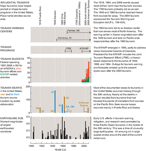
FIGURE 1.2 Timelines for U.S. tsunami warning centers, programs, tsunami budget, deaths from tsunamis in the United States and its territories, and earthquakes of magnitude 8.0 or larger worldwide since the year 1900. Sources of data for this figure include: NOAA (federal spending); http://www.ngdc.noaa.gov/hazard/tsu_db.shtml (tsunami fatalities); http://earthquake.usgs.gov/earthquakes/eqarchives/ (great earthquake history). SOURCE: Committee member.
part of its mitigation efforts it has issued Guidelines for Design of Structures for Vertical Evacuation from Tsunamis (Federal Emergency Management Agency, 2008). FEMA becomes the lead federal agency in managing the emergency response once a tsunami has caused damage to U.S. coastlines.
The National Science Foundation (NSF) used to be a partner of the NTHMP, but as its involvement decreased the decision was made in 2009 to remove it from the NTHMP. Its primary function is to provide research funding and to partner with other federal agencies in research and development. NSF provides funding for the GSN. NSF has also been actively involved with investments regarding tsunami research infrastructure, such as the Network for Earthquake and Engineering Simulation (NEES), Earthquake Engineering and Research Centers (EERCs), and the Southern California Earthquake Center (SCEC) (Bement, 2005). Because it is not part of the NTHMP and its funding decisions are primarily driven by the demand in the research community, this report does not include an explicit discussion of NSF’s role but rather discusses the role of the broader research community in the nation’s tsunami efforts.
NOAA has been carrying most of the responsibility and obtains most of the funding to provide tsunami warnings, maintain observing networks (including seismic networks not funded by the USGS in Alaska and Hawaii), manage and archive data, and conduct research (further discussed in the next section).
The coastal states, U.S. territories, and commonwealths contribute their own initiatives and resources to the nation’s preparedness and education efforts; these vary in extent and approach from state to state. In particular, states are responsible for providing communities with inundation maps that allow municipalities to produce evacuation maps and guidance, and to educate the public about the hazard and appropriate responses. Local officials in turn are responsible for transmitting tsunami alerts throughout their respective jurisdictions, issuing evacuation orders, managing evacuations, and declaring all-clears.
NOAA’s Tsunami Program
In 2006, the Tsunami Warning and Education Act (P.L. 109-424) charged NOAA with addressing the nation’s priorities in tsunami detection, warning, and mitigation. NOAA’s Tsunami Program assumed the responsibilities to plan and execute NOAA’s tsunami efforts, primarily the program’s budget, strategic plan, and the coordination of activities among its NOAA organizational components and external partners, including the NTHMP. NOAA’s Tsunami Program advocates an end-to-end TWS, which includes detection, warnings and forecasts, message dissemination, outreach and education, and research.
NOAA’s Tsunami Program is supported by five line offices (Table 1.1): NWS; the Office of Marine and Aviation Offices (OMAO); the National Ocean Service (NOS); Oceanic and Atmospheric Research (OAR); and the National Environmental Satellite, Data, and Information Service (NESDIS). The NWS, as the administrator for NOAA’s Tsunami Program, is primarily responsible for helping community leaders and emergency managers in strengthening their local tsunami
TABLE 1.1 Tsunami Program Matrix
|
Tsunami Program Capabilities |
Line Offices |
|||||
|
NWS |
OAR |
NOS |
NESDIS |
OMAO |
||
|
Weather and Water Goals |
Hazard Assessment |
Modeling and Mapping (tsunami source, propagation, coastal elevations, and inundation) Assessments (exposure and vulnerability, historical event records, social and economic impacts) |
||||
|
Warning Guidance |
Earthquake Detection |
|
Sea level Monitoring, Inundation Detection |
Geophysical and Oceanographic Data Management and Long-Term Archive |
Detections System O and M Support |
|
|
Bottom Pressure (Tsunami) Detection |
Water Current and Geodetic Reference |
Aerial and Ship Coastal Survey |
||||
|
Data Management and Communication |
Ocean-Data Management and Communications |
|
||||
|
Warning and Forecast Analysis and Notification |
Warning and Forecast Development |
|
||||
|
Mitigation and Preparedness |
Coordination (Federal-State-Local-Tribal) for Community-Based Education, Outreach, and Planning |
|
||||
|
Capacity Building; Standards and Guidelines; Coastal Resilience |
||||||
|
Hazard Awareness and Integrated Coastal Area Management |
||||||
|
Technology Transfer, Transition, and Training |
||||||
|
Research |
||||||
|
Tsunami Science, Modeling and Mapping, Sensors, Detection and Prediction, Ocean Exploration |
||||||
|
International Coordination |
Inter-governmental (IOC, WMO, ISDR, GEO…):a Hazard Mapping, Technology Transfer and Education, Data/Information Exchange, Observations and Communication, Standards and Policy |
|||||
|
Interagency (USGS, FEMA, NSF, DOS/USAID):b Hazard and Risk Assessment, Coastal-Ocean Observations, Data Management, Direct Foreign Assistance, Capacity Building, and Foreign Policy |
||||||
|
a IOC: Intergovernmental Oceanographic Commission; WMO: World Meteorological Office; ISDR: International Strategy for Disaster Reduction; GEO: Group on Earth Observations. b USGS: U.S. Geological Survey; FEMA: Federal Emergency Management Agency; DOS: Department of State; USAID: U.S. Agency for International Development. SOURCE: Data from National Oceanic and Atmospheric Administration, 2008a. |
||||||
warning and preparedness programs through its TsunamiReady program as well as operating the TWCs.
The Pacific Region’s Pacific Tsunami Warning Center (PTWC) and the Alaska Region’s West Coast/Alaska Tsunami Warning Center (WC/ATWC) are administered within the NWS, although the two TWCs report to their respective regional NWS offices. The two TWCs have distinct areas of responsibility as described in Chapter 5. The NWS also houses the National Data Buoy Center (NDBC), which operates and maintains the Deep-ocean Assessment and Reporting of Tsunamis (DART) buoys. These buoys monitor and alert the TWCs of sea level changes associated with a tsunami. OMAO collaborates by providing detection system maintenance support and conducting coastal surveys. NOS provides state and local coastal emergency managers with hazard-related information such as training and assessment tools, and also operates coastal tide stations and sea level gauges that monitor changes in sea level. OAR comprises a research network involving internal research laboratories, grant programs, and collaborative efforts between NOAA and academic institutions. Pacific Marine Environmentla Laboratory (PMEL), within OAR, focuses on designing optimal tsunami monitoring networks, improving forecast modeling, and improving impact assessment on coastal communities. NESDIS provides access to global environmental data; such as climate, geophysical, and oceanographic data. The National Geophysical Data Center (NGDC), housed within NESDIS, manages a database for historic tsunami events, maps, and DART and tide gauge records. Some negative consequences arising from this distribution of tsunami detection, forecast, warning, and planning functions across different parts of NOAA and across different NTHMP partners is discussed in greater detail in Chapters 3 and 5.
ASSESSING THE NATION’S EFFORTS
Because tsunami warning and preparedness efforts are distributed across federal and state agencies and were historically conducted without a federal coordination mechanism, the committee faced a number of challenges in assessing progress in the nation’s ability to warn and prepare for the threat of tsunamis. The first challenge results from the need to assess many individual activities. Secondly, it is difficult to extrapolate from these individual activities to assess whether all the distributed efforts can function coherently during a tsunami to warn and evacuate people in a timely fashion. To help address these challenges, the committee began its analysis by sketching the required functions and elements of an idealized integrated warning and preparedness effort based on available research findings in the hazards and high-reliability organizations (HRO) literature (see section below). The committee then sought to compare its vision of an idealized system with the evolving status quo.
An ideal integrated TWS comprises multiple technologies, systems, individuals, and organizations. A comprehensive view of the elements therefore includes technical, organizational, social, and human components. The ideal system incorporates risk assessment, public education, tsunami detection, warning management, and public response (Figure 1.3).
Protecting and warning the public begins with an understanding of the tsunami risk envi-
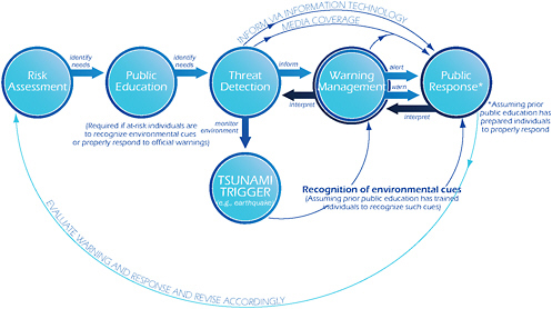
FIGURE 1.3 Components of an integrated warning system: Risk assessment includes all assessments required to effectively plan evacuations (including tsunami source determination, inundation modeling, and evacuation mapping) and prepare the communities to evacuate in the event a warning is issued or received. Risk assessments identify needs for public education. Public education aims to ensure maximum preparedness and a public that knows what to do when it receives a warning or feels the ground shaking in the case of near-field tsunamis. Threat detection comprises the continuous monitoring of the natural and technological environments that could create an emergency; it informs the warning management and public response component using threshold criteria and communication technology. Warning management interfaces the threat detection component with the public response component and is responsible for tsunami alerts, warnings, and evacuations; in consultation with the threat detection component it will alert and warn the public. Public response is the ultimate outcome of the integrated warning system, and it integrates public education, threat detection, natural cues from tsunami triggers, and warning management. SOURCE: Committee member; design by Jennifer Matthews, University of California, San Diego.
ronment. This must be done before a tsunami is generated in order to design the threat detection system, the education and awareness campaigns, and the evacuation and response plans. To understand the risk environment, both hazards (the physical characteristics of tsunamis and the inundation area) and vulnerabilities (the people and properties in harm’s way) need to be characterized (National Research Council, 2006). Pre-event public education is required to enable at-risk populations to correctly interpret: (1) natural cues from the environment (e.g., ground shaking from the earthquake) or (2) warnings from a technical detection system as a signal to evacuate to higher ground in a timely fashion. The threat detection component monitors the environment for threshold events using cues from natural and technical systems (Mileti, 1999; Mileti and Sorenson, 1990).
Once a significant tsunami is detected, the warning process needs to be managed. Tsunami information needs to be analyzed and decisions have to be made about the extent of the warning. Managers and decision makers issue warnings directly to the public. Ideally, officials managing the response also maintain situational awareness and information flow between the technical detection system and the public to update warnings and messages with the required protective actions to be taken. Because of the dominance of real-time communications, the Internet, and social networking, both the general public and media will increasingly access tsunami information directly from real-time information sources (e.g., the TWCs, seismometers, and water-level gauges) before local officials are able to respond. The public’s real-time access to different information sources, such as social media and networking systems, underscores the importance of public education to prepare both the public and the press for proper interpretation of information and response to detected hazards. An effective warning system monitors the public’s response and reactions in order to improve its processes for effective, understandable, actionable, reliable, and accurate warnings of impending danger. In the following chapters, the report covers the system components and compares the idealized system with current and/or planned efforts.
An integrated TWS has an impact on large populations and on a wide range of resources and, in the event of failure, has the potential to cause enormous economic, social, organizational, technological, and political losses. Although often seen as mainly comprising technical and technological elements, a warning system must, out of necessity, include the human dimension, such as people’s behavior, policies, procedures, and organizations. However, it is the human dimension that poses a significant challenge:
This involves the setting and running of national services (people), and the implementation of complex emergency-preparedness and awareness plans at the national and local levels to immediately inform every person of the threat. In the building of any early warning system, this is the difficult part. (Intergovernmental Oceanographic Commission, International Strategy for Disaster Reduction, and World Meteorological Organization, 2005).
CHALLENGES TO REDUCING THE NATION’S VULNERABILITY TO TSUNAMIS
Reducing the vulnerability of coastal settlements and infrastructure to tsunami risk poses some unique challenges. Although tsunamis can be devastating, as was seen during the 2004 Indian Ocean event, catastrophic tsunamis are relatively infrequent. This infrequency makes it more challenging to sustain the capacity to educate, warn, and prepare for this particular hazard. As discussed above, the history of tsunami warning and mitigation efforts in the United States shows that significant new funding is often made available only after a tsunami has devastated a coastal community and caused casualties. High funding levels and commitment to tsunami mitigation dissipate over time, leading to difficulties in maintaining efforts, knowledge, and lessons learned over time. Another challenge is the need to relay warnings from the fed-
eral government to state and local officials in just minutes (in the case of a near-field tsunami) or hours (in the case of a far-field tsunami). Sustaining the organizational preparedness and coordination across many jurisdictional boundaries presents a daunting challenge.
The committee recognizes that the nation’s tsunami detection, warning, and preparedness efforts originated in many diverse efforts distributed across several coastal states, and that attempts to integrate these distributed components into a coherent program have only recently begun. In particular, because tsunamis are rapid onset events, there is very little margin for error in the system before failure becomes catastrophic. An organization that operates in a low probability, high-risk environment, allowing few errors, is called an HRO (Roberts, 1990). HROs manifest a number of common properties: flexible and adaptable organizational structures, continually reinforced organizational learning, decision making that is both flexible and mobile, a strongly reinforced organizational culture, constant and effective communication, and trust among members of the system, particularly across organizations (Grabowski and Roberts, 1999; Grabowski et al., 2007). Because the committee identified the need for high-reliability operations in TWSs, the committee draws from the research literature on HROs (Roberts, 1990) and resilient systems (Hollnagel et al., 2008) to highlight particular characteristics that reduce the risks of failure in an idealized end-to-end warning system:
-
Situational Awareness in an Emergency: Because tsunamis are events that allow only minutes to hours for evacuation, a keen sense of situational awareness and the ability to respond quickly and effectively is required (Weick, 1990, 1993, 2003). HROs require decision making that is adaptable to change and surprise, and that is able to continually reassess needs across distributed organizations (Weick, 1993, 1998; Weick et al., 1999). Such is the case with the nation’s tsunami warning and preparedness efforts, where the TWCs, the state and local offices, and emergency managers and the affected public are geographically dispersed and often lack face-to-face contact. The dispersed and decentralized nature of the end-to-end tsunami warning and preparedness efforts make it a significant challenge to maintain awareness of the evolving situation during a crisis.
-
Learning and Training: To maintain situational awareness under changing conditions requires training. Therefore, an effective TWS requires that watchstanders, emergency managers, regulators, the public, and the media learn together, and engage in learning that enhances sense-making and developing alertness to small incidents that may cascade into much larger disasters (Weick, 1993; Farber et al., 2006). Because of the low frequency of tsunamis (e.g., California is issued an alert bulletin on average once every three years; Dengler, 2009), a TWS has few opportunities to learn from an event and therefore needs to learn from exercising the system through drills. Trial and error can be disastrous not only because disasters are rare, but also because in the absence of a major catastrophe to focus attention in the system, lessons learned from previous events may be forgotten or misapplied (March et al., 1991; Levitt and March, 1988; De Holan and Phillips, 2004). Learning in a high-reliability organization needs to be systematic, continually reinforced, measured, and made part of the system’s core values.
-
Fluid Organizational Structures: HRO structures are often adaptable and fluid, allowing the system to expand or contract in response to its environment (Roberts, 1990). TWSs with flexible organizational structures would be able to expand and contract resources in response to shifts and changes in environmental demands, disasters, or periods of slack resources. In the event of a tsunami, TWS managers need to grow effective, functioning response organizations in a period of less than 24 hours, and then adjust the organizational structures to the needs of the response (Tuler, 1988; Bigley and Roberts, 2001). The ability to provide varied organizational structures in response to environmental demands may be critical to the success of TWS organizations, similar to the way fire and emergency organizations expand and contract in response to fire demands (Grabowski and Roberts, 1999). Distributed information technology that connects the system responders can provide the technological glue that ties HRO members together, and fluid organizational structures can allow the organization to grow, expand, contract, and respond to changes in a dynamic, high tempo environment (Bigley and Roberts, 2001). Similar requirements for members and organizations in TWSs can be envisioned as tsunami conditions unfold.
-
Strong Organizational Culture: Schein (1992, 1996) defines “culture” as a set of basic tacit assumptions, that a group of people share, about how the world is and ought to be; it determines their perceptions, thoughts, feelings, and to some degree, their overt behavior. In many organizations, shared assumptions typically form around the functional units of the organization and are often based on members’ similar educational backgrounds or experiences (Grabowski and Roberts, 1996, 1997). HROs are characterized by strong cultures and norms that reinforce the organization’s mission and goals and that focus attention on procedures, policies, and reward structures consistent with the organization’s mission and safety (LaPorte and Consolini, 1991). HROs have cultures attentive to errors; cultures where closely held ideas about the organization, its mission, and member roles in reliability enhancement are articulated; cultures that encourage learning; and cultures where safe areas—for decision making, communication, and the like—are created as buffers (Weick, 1993). Constructs such as oversight and checks and balances reinforce the strong cultural norms of the HRO. Melding the varied cultures that integrate the system into a cohesive whole can be extremely difficult in distributed systems that are connected by linkages that can dissolve and wane as requirements, organizational structures, and political will change (Weick, 1987; Weick and Roberts, 1993; Grabowski and Roberts, 1999).
Managing decision making across organizations that report to different management structures is a challenge for highly dispersed efforts; this is certainly the case with U.S. tsunami detection, warning, and preparedness efforts. A particular challenge is that the federal government has responsibility to forecast and warn about potential hazards, yet local governments order evacuations. Failure to consider distributed decision making within groups and across multiple units can lead to lack of readiness for the next large-scale catastrophe; e.g., Hurricane Katrina (Roberts et al., 2005; Farber et al., 2006). Building good communication and trust aid in
effective decision making and can increase the likelihood of success in geographically dis-tributed organizations. Trust can be built by common training; opportunities for scientific and operational exchange; and workshops, conferences, exercises, and simulations that build community and coherence across distributed organizations.
TYING IT ALL TOGETHER: REPORT ROADMAP
In the following chapters, the committee assesses progress in the nation’s distributed tsunami preparedness, detection, and warning efforts and compares it to its vision of an idealized warning system (Figure 1.3). Chapter 2 evaluates progress in hazard and vulnerability assessments and identifies potential improvements that could guide the nation’s tsunami risk-assessment efforts. Chapter 3 discusses education and outreach efforts and evaluates pre-event community and organizational preparedness and the coordination between the various entities at the local, state, and federal levels. Chapter 4 examines the technical hazard detection system, including the seismic and sea level sensor networks. Chapter 5 examines the TWCs’ operations and how technology and human capital are used to provide their functions. Appendices present supporting data on tsunami sources, hazard and evacuation maps, educational efforts, seismological methods, and several case-study tsunamis.


