
CHAPTER SEVEN
International Information Needs
Information from other countries is essential to plan for and respond to climate change for a number of reasons: (1) the economic and market couplings of the United States with the rest of the world, particularly in agriculture; (2) shared water and other natural resources; (3) disease spread and human health; (4) humanitarian relief efforts; and (5) national security. This chapter highlights that the United States needs to be an active participant in improved sharing of global data, increased monitoring and surveillance of climate variability and climate change, and developing institutions that can be flexible and respond to changing circumstances.
ECONOMIC AND MARKET COUPLINGS
The world is connected by the flow of goods, materials, food products, and more. This means that activities and events that affect one region halfway across the world, or across our borders, can affect the U.S. economy. The reverse is also true. In particular, agricultural linkages are very important, especially when considered in the context of climate change. In general, countries that currently import most of their food may have to increase their net imports as climate changes negatively affect their crops and domestic agriculture. Developing countries, where climate change will make presently dry areas even drier, will become increasingly reliant on food imports (World Bank, 2010). The trade markets in food are very dependent on key regions, with just the United States, Australia, and Russia being major net exporters (Figure 7.1) (FAO, 2008). Countries that import most of their food will become increasingly dependent on the agriculture and food production from those major net exporters and thus will become more vulnerable to shifts in production and price due to extreme weather events associated with climate change (World Bank, 2010). Severe weather events, such as droughts, floods, and typhoons, have reverberations around the world as the recent food crises have shown. United States farmers and commodity markets are sensitive to changes in climate and markets across the world and can benefit from timely and accurate information about crop conditions elsewhere. Such information is currently provided by the USDA Foreign Agricultural Service, U.S. embassies, the USAID Famine Early Warning systems, and initiatives such as NOAAs ENSO forecasts and benefits
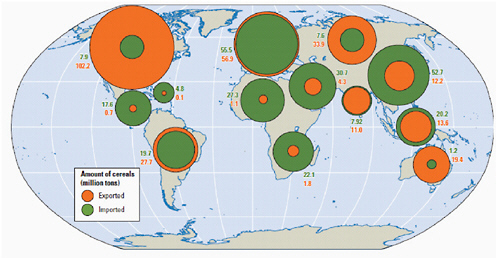
FIGURE 7.1 This world map illustrates how global cereal production and trade depends on very few countries. SOURCE: FAO (2008), as redrawn in World Bank (2010).
from innovations in remote sensing. United States food and fiber processing industries also require information on conditions in key countries exporting to the United States, with some companies maintaining in house climate expertise in order to gain comparative advantage in climate-sensitive global markets. Climate change will make it harder to produce enough food for the world’s growing population, and the global rate of agricultural productivity growth will need to almost double while minimizing the associated environmental damage (IPCC, 2007; Rosegrant et al., 2009). This will require dedicated efforts to identify crop varieties able to withstand climate shocks, as identified by the reports Advancing the Science of Climate Change (NRC, 2010b) and Adapting to the Impacts of Climate Change (NRC, 2010a), as well as improved early warning information about extreme weather events. Global events such as the 1997-1998 strong El Niño and the weaker El Niños in 2002, 2004, and 2006 have shown how timely and effective climate forecasts and assessment information lead to enhanced resilience in domestic and international sectors such as disaster management and agriculture (NRC, 1999). Better forecasting and management of continental drought, with an emphasis on risk management rather than crisis management, can help in coping with more extensive climate change in the future. Two models of such approaches are the Australian Drought Policy (Wilhite et al., 2005) and the U.S. Western Water Assessment (WWA).1 The United States will increasingly need information about seasonal,
|
1 |
Boulder, CO, http://wwa.colorado.edu/index.html. |
interannual and decadal extreme events to effectively prevent and respond to domestic and international food crises.
SHARED RESOURCES AND ECOLOGICAL SERVICES
The United States shares not only water across our borders (Figure 7.2), but also fisheries, migrating species (birds, whales, waterfowl, etc.), and many ecosystem services (such as flood control by buffer areas and wetlands filtration of pollutants). As climate change makes resources harder to manage, and growing populations increase demand, countries will need to cooperate more intensively to manage international waters, forests, wildlife, and fisheries (SEG, 2007). Thus, the United States must provide and procure information across borders, making sharing of real-time data more important. For example, changes in the timing and availability of water will affect agricultural production, sanitation, drinking-water quality and cost, water supply reliability, ecosys-
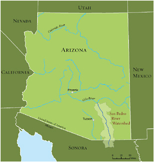
FIGURE 7.2 The San Pedro River watershed is an example of shared water resources across our borders. SOURCE: Dale Turner and The Nature Conservancy; TNC (2010).
tem services, and hydropower generation in neighboring Canada and Mexico. Impacts in more distant countries will also have broader economic and trade effects on the United States.
Climate change impacts will also strain existing domestic and international institutions and resource-management capabilities. Given the universal and transnational character of climate impacts on natural resources, there is a special role for integration of international information and agencies to facilitate helping the United States and other nations to cope with climate change. Few international organizations were designed with climate change in mind but will increasingly need to incorporate information about changing trends. For example, the International Joint Commission was set up between the United States and Canada to protect water quality and quantity in the Great Lakes regions (GLWQ, 2003). Future lake water levels are expected to drop as climate changes with concomitant increase in evaporation and decreases in ice cover. This will require managing outside of historic norms and both countries will need to set new operating rules (Bierbaum et al., 2008). Similarly, the United States is currently a party to (or considering becoming a party of) a number of environmental treaties designed to tackle problems other than climate change, but which will interact with efforts to respond to climate change. The established goals and roles of different countries in these treaties should be revisited. Among the pertinent treaties are those on biodiversity (Convention on Biological Diversity) and desertification (United Nations Convention to Combat Desertification), the Ramsar Convention on Wetlands, the Convention on Shared International Watercourses, and the International Treaty on Plant Genetic Resources for Food and Agriculture. The United States and other nations need to jointly evaluate how to sustain international ecological services from lands and waters in the face of climate change. Decisions will have to be with other countries about how to allocate harvesting of marine resources and (already overexploited) fisheries, and how to manage species as they relocate into new areas, such as the Arctic Ocean, to find suitable conditions. This will also be true for terrestrial species, as climate change is proceeding at rates 2 to 10 times the normal rates of migration (IPCC, 2007a); many ecosystems are being disrupted already and may not be able to persist without nations facilitating migration toward the poles or active preservation of individual species.
State and local governments along borders also have strong interest in the management of shared waters and ecosystems, as do the large number of U.S. conservation groups that operate internationally in attempts to protect internationally significant ecosystems. Non-federal governments and conservation groups are generating useful data and information at the local level, can supplement information that is missing at
national and international levels, and are major users of international data generated by the U.S. Federal government and international organizations.
HUMAN HEALTH
The H1N1 outbreak has reinforced how easily infectious agents cross borders. Historically, the Centers for Disease Control and Prevention in the United States focused mainly on health effects within our borders and on efforts to keep these under control. Many threats to human health will clearly increase as the U.S. climate becomes warmer and leads to more heat stress in vulnerable populations. As well, warmer temperatures provide suitable habitat to more disease vectors. Increasingly, U.S. doctors will need to be trained in tropical medicine in order to recognize new diseases. For example, dengue fever (a viral disease) has been expanding its geographic range northward to the United States, and climate change is already accelerating the comeback of dengue to the Americas. In the United States, the incidence has already doubled over the past decade (PAHO, 2009). To detect and monitor the spread of diseases and prevent them from reaching epidemic proportions, national health systems will need to upgrade surveillance and enhancement of early warning systems and include information about conditions along and beyond the U.S. border (WHO, 2008).
The United States is also dependent on receiving good information from international sources to protect its own citizens from disease spread as they travel the world. Today, surveillance in many parts of the world fails to anticipate new disease pressure, for example, in Africa, where malaria is increasing rapidly (Keiser et al., 2004). Satellite remote-sensing and biosensors can improve the accuracy and precision of surveillance systems and prevent disease outbreaks through early detection of changes in climate factors (Rogers et al., 2002). Advanced seasonal climate forecast models can now predict peak times for malaria transmission and give regional authorities in Africa information to operate an early warning system and longer lead times to respond more effectively. Improving such capabilities will also safeguard American travelers (Frumkin and McMichael, 2008). The United States benefits from close cooperation and information sharing with other countries and with international organizations such as the World Health Organization as well as international foundations (e.g., The Gates Foundation).
HUMANITARIAN REASONS
The United States responds to global disasters with increases in foreign aid following floods, droughts, cyclones, earthquakes, and tsunamis for humanitarian and strategic
reasons. Even in the absence of climate change, the United Nations University’s Institute for Environment and Human Security cites predictions that by 2010 the world will need to cope with as many as 50 million people fleeing environmental degradation (SEG, 2007). Climate change could further augment the number of environmental refugees given that the frequency and intensity of floods, droughts, and fires will increase. Flooding of low-lying areas as sea level rises will displace additional tens of millions of people across the globe. As well, hurricanes and cyclones that form are expected to be more intense as climate changes, with higher wind speeds and increased rainfall (IPCC, 2007b). Environmental refugees due to climate may already being appearing as the climate warms and the environment deteriorates (Black, 2001). Natural droughts, compounded by poor agricultural practices and land-tenure policies, have contributed to severe famines in recent decades, which in turn led to the displacement of large numbers of people worldwide. Closer to home, Hurricane Mitch created so much local devastation in Central America that it drove thousands of displaced people to relocate, causing significant refugee pressures in nearby countries, including the United States (Glantz and Jamieson, 2000). Worldwide, weather-related disasters in 2005 exceeded $300 billion in insured and uninsured losses.
No nation is immune to the impacts that these global disruptions cause. The United States has experience in responding to climate-driven disasters such as hurricanes and droughts and such recovery efforts would benefit from good information systems to evaluate the success of the responses, and to reduce vulnerability in the future. The United States needs better information on the frequency and intensity of extreme events, which requires improved global monitoring systems. Also, federal and international organizations need to prepare to respond to a refugee and resettlement problem of significantly greater magnitude and longer duration than that for which they have currently planned.
Humanitarian NGOs have considerable interest in international disaster response because responding to international humanitarian emergencies is at the core of their missions. For example, following Hurricane Mitch in 1998 (Figure 7.3), emergency response teams from aid organizations such as USAID and Oxfam were sent to care for the injured and to provide water, food, and shelter. Humanitarian NGOs are an important source of information on what is happening at the local level within other countries (e.g., Oxfam’s climate witness program and Red Cross/Red Crescent’s Climate Centre) and use information generated by the U.S. government and international organizations to target their efforts, inform the public, and assess the successes and failures of their programs. In addition, the U.S. military has the capability to respond quickly and effectively to disasters and to promote stability in the affected regions; however, the expected in-
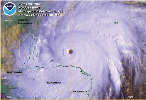
FIGURE 7.3 Hurricane Mitch. SOURCE: NOAA (1998).
crease in the frequency and intensity of natural disasters may negatively affect military readiness in other parts of the world (CNA, 2007).
NATIONAL SECURITY
Many of our overseas deployments reflect the strategic decision to ensure the free flow of oil to the United States and to our allies (CNA, 2009). But climate disruption and consequent social upheaval anywhere in the world can also lead to conflicts that will adversely affect U.S. interests of one kind or another, potentially necessitating a U.S. diplomatic and/or military response. Climate change itself can have impacts on the types of missions security forces must perform as well as the ways in which the military carries out those missions. For example, the effectiveness of some military operations could be influenced by the durability of equipment in extreme weather, the location and vulnerability of military bases to issues such as sea level rise and hurricanes, and a lack of reliable infrastructure to support transportation and energy needs (CNA, 2007). Impacts such as floods, droughts, wildfires, powerful storms, and pest outbreaks
can increase “civil defense” demands. An ice-free Arctic will lead to shipping traffic, which will increase patrol requirements (see Box 5.1).
Climate change could interact with other international tensions and increase the chance of conflict (CNA, 2007). Water shortages in international basins, contention over ownership and access to ice-free arctic resources, and disputes and tensions over responsibility and compensation for climate-change damages are likely to ensue. If the United States struggles to relocate its own citizens as sea level rises (e.g., some of the land south of New Orleans will lose up to a meter this century from subsidence alone; sea level rise of up to a meter will be on top of that), migration to our borders of millions of people from Latin America and the Caribbean could tax humanitarian assistance (Woolsey, 2008).
Remedies chosen to address climate change could either reduce or enhance the potential for conflict. Reducing dependencies on Middle East oil could lessen conflict. Efforts to increase natural gas use (because its CO2-to-energy ratio is better than that of oil or coal) may increase dependence on Russian gas and the potential for conflict. Expanding nuclear energy enough for a big impact on CO2 emissions means thousands of reactors globally; controlling enrichment (highly enriched uranium) and reprocessing (plutonium) at this scale is daunting and the potential for proliferation would greatly increase.
In the face of these challenges to national security, several military experts recommended that the United States adjust its national security and national defense strategies to account for the possible consequences of climate change. For example, the Department of Defense could conduct an impact assessment of how rising sea levels, extreme weather events, and other effects of climate change might affect U.S. military installations over the next three to four decades. Beyond the direct military dimension, enhancing the resilience of the international community in the face of climate-related threats by strengthening the governance, health care, and disaster prevention and relief capabilities of foreign countries will also indirectly help the United States (Campbell and Parthemore, 2008).
WAYS FORWARD
Creating a Global System of Observations
Demand for sustained and reliable data and information on trends, unusual events, and long-range predictions at international scales has never been greater than it is today. Each of the international information needs sections above highlights the im-
portance of observations for monitoring short- and long-term climate trends, warning of ecological or socioeconomic tipping points, characterizing regional vulnerability and impacts, and evaluating the efficacy of mitigation and adaptation responses. Climate information from both domestic and international sources must be increasingly incorporated into planning by sectors as diverse as agriculture, transportation, energy, insurance, water, and fisheries.
Improved seasonal outlooks for both U.S. and overseas locations can be used to assist farmers in the choice and timing of crops they plant and animal stocking levels, and to help water resource managers plan storage levels in dams to avoid floods and retain water needed for irrigation. Improved observations of the atmosphere will lead to more accurate and more extended weather forecasts, which will become particularly important as climate change leads to more intense convective rainfall events, more powerful and flood-inducing tropical cyclones, and more intense and frequent heat waves. Increased warning times will allow more effective protection of human life and property, better prediction of storm tracks and flood potential, and improved forecasts of air pollution levels. Advanced observations of the land surface will allow careful monitoring of the state of forests, grasslands, and other ecosystems, which will become particularly important as climate change shifts their natural ranges. This information should help in identifying those regions most susceptible to fire, in managing wildlife as snow cover and sea-ice extent change, and in irrigating crops and reducing pest damage through periods of drought or excess moisture. Coupled to a broader network of observations to be assembled into a Global Earth Observation System of Systems (GEOSS), these measurement systems and others—along with special measurements of the state of the polar ice sheets, the melting of which could more rapidly raise sea level around the world—have the potential to reduce the vulnerability to adverse impacts of climate change by enhancing warning times and resilience (see Box 7.1).
A global climate observing system could provide the climate-relevant information that society needs to better plan for and anticipate climate conditions on timescales from months to decades. Such an enterprise would build on existing observation systems but must go far beyond them. It must provide information to help farmers decide on appropriate crops and water management during droughts, on appropriate infrastructure to cope with the new 100-year extreme precipitation and storm surge events, monitor changing carbon stocks and flows in forests and soils, and evaluate efficacy of disaster response strategies under changing climate conditions. The original scientific objectives of NASA’s Orbiting Carbon Observatory (OCO), which failed on launch in February 2009, was to study natural CO2 sources and sinks. However, OCO would also have provided proof of concept for spaceborne technologies to monitor greenhouse
|
BOX 7.1 TOGA-COARE and Seasonal Climate Prediction The Tropical Ocean Global Atmosphere Coupled Ocean Atmosphere Response Experiment (TOGA-COARE) has made major advances in the understanding of the strongest climate variation on seasonal-to-interannual time scales, El Niño and Southern Oscillation (ENSO). ENSO events, which occur every 3 to 8 years, involve a periodic change in the tropical Pacific atmosphere and ocean. These events are associated with extreme weather and climate anomalies, such as droughts in Australia, India, and Africa; floods in South America; and severe winter storms in the United States. Climate variations such as ENSO have serious impacts on human affairs, including loss of life, crop failures, and depletion of fisheries. In the past, these events could not be predicted in advance, which inhibited decision makers and governments from take effective actions to respond to their impacts. The 1982-1983 ENSO, which was not predicted or even detected, resulted in economic damages in the North and South Americas, including the United States, and also in Africa and Asia. This event spurred concrete actions by decision makers. To better understand the implications of the ENSO and predict climate phenomena on time scales of months to years, the TOGA program was initiated in 1985 by the World Meteorological Organization (WMO) with contributions from 16 nations including the United States. Goals were achieved through long-term monitoring of the upper ocean and the atmosphere, specific process-oriented studies, and modeling (WCRP, 1985), which were implemented by a series of national, multinational, and international efforts (e.g., NRC, 1986b; WCRP, 1986a). In-situ observation programs such as the array of moored buoys in the Pacific known as the Tropical Atmosphere-Ocean (TAO) project were developed to provide these oceanographic data sets along with satellite observations and other sources of data. Seasonal forecasting of the ENSO cycle has dramatically influenced operational decisions made within industries such as agriculture and utilities. Research has estimated that ENSO forecasting may benefit U.S. agriculture decision making, resulting in a net economic value between $507 and $959 million/year (Chen et al., 2002). According to the 1986 NRC report, “TOGA opened the way to the future of seasonal-to-interannual climate predictions. The follow-on programs will further develop the means of predicting the climate for the ultimate benefit of humankind.” The TOGA program is widely regarded as an epitome of success, bringing together observation and monitoring, research and modeling, and service elements, and resolving issues of practical significance that were traceable to climate variations. This entails resources of all kinds (intellectual, monitoring, computational, etc.) and highlights the importance of relevant milestones of progress. Nevertheless, the success of the TOGA program brought together a multiplicity of countries, along with climate and social scientists, and economic and resource planners, and it represents a stark success of the goals that can be achieved provided the problem and the pathway to solving it are framed in a substantive manner and executed with due diligence. |
gas emissions, as well as baseline emissions data. Such monitoring and verification of emissions reductions to support a greenhouse gas reduction treaty will also be needed (NRC, 2009c, 2010e). A successor to OCO will be decided on by the U.S. government in the next year.
Some of the additional necessary information to develop a Global System of Observations is being provided by United States National Meteorological and Hydrologic Service Centers and increasingly by Global Climate Observing System contributions through various government agencies and nongovernmental institutions. When the UNFCCC was negotiated, provision for the establishment of a Global Climate Observing System (GCOS) was initiated. Subsequently, GCOS was established by the WMO, UNEP, ICSU, and the Intergovernmental Oceanographic Commission (IOC) of UNESCO to ensure that all the observations required for climate monitoring, research, prediction, services, assessment, and climate change mitigation and adaptation are obtained, archived, and made broadly accessible to address multiple societal needs.) Also, a number of other institutions, such as the World Data Centers and the International Research Institute, regularly provide climate-related data and products including forecasts on monthly to annual timescales.
There are also a few examples of fledgling regional but international climate services. One such example is the Pacific Climate Information System (PaCIS), which provides a regional framework to integrate ongoing and future climate observations, operational forecasting services, and climate projections. PaCIS facilitates the pooling of resources and expertise, and the identification of regional priorities. One of the highest priorities for this effort is the creation of a web-based portal that will facilitate access to climate data, products, and services developed by the NOAA and its partners across the Pacific region.
Another example is the formation of regional climate centers, which the WMO has formally sought to define and establish since 1999. The WMO has been sensitive to the idea that the responsibilities of regional centers should not duplicate or replace those of existing agencies but instead support five key areas: (1) operational activities, including the interpretation of output from global prediction centers; (2) coordination efforts that strengthen collaboration on observing, communication, and computing networks; (3) data services involving providing data, archiving it, and ensuring its quality; (4) training and capacity building; and (5) research on climate variability, predictability, and impacts in a region.
Building a comprehensive and integrated system to monitor environmental changes across the planet is beyond the means of any single country, as is analyzing the wealth of data it would generate. That is why the Group on Earth Observation (GEO),
a voluntary partnership of governments and international organizations, developed the concept of a Global Earth Observation System of Systems (GEOSS). Providing the institutional mechanisms to ensure the coordination, strengthening, and supplementation of existing global Earth observation systems, GEOSS supports policy makers, resource managers, scientific researchers, and a broad spectrum of decision makers in nine areas: disaster risk mitigation, adaptation to climate change, integrated water resource management, management of marine resources, biodiversity conservation, sustainable agriculture and forestry, public health, distribution of energy resources, and weather monitoring. Information is combined from oceanic buoys, hydrological and meteorological stations, remote sensing satellites, and internet-based Earth-monitoring portals. Some early progress includes the following:
-
In 2007, China and Brazil jointly launched a land-imaging satellite and committed to distribute their Earth observation data to Africa.
-
The United States recently made freely available 40 years of data from the world’s most extensive archive of remotely sensed imagery.
-
A regional visualization and monitoring system for Mesoamerica, SERVIR, is the largest open-access repository of environmental data, satellite imagery, documents, metadata, and online mapping applications. SERVIR’s regional node for Africa in Nairobi is predicting floods in high-risk areas and outbreaks of Rift Valley fever.
-
GEO is beginning to measure forest-related carbon stocks and emissions through integrated models, in situ monitoring, and remote sensing.
Improving Analytical Capabilities, Sharing of Best Practices, and “Learning by Doing”
Increasing observational capabilities is only the first step in a longer process of improving decision making in the context of climate change. The data collected by satellites, gauges, and instruments, and the information produced by modeling and forecasts, are only helpful if useable. Acting upon this information requires not only distilling and packaging the information into formats familiar to decision makers, but also domestic and international managers, consultants, and practitioners to acquire and employ new techniques, methods, and skill sets. Throughout this report the panel has described various information needs for different decision makers such as a hydroelectric dam manager, transportation official, and a fisheries manager (see Boxes 2.3, 5.2, and 5.3, respectively). Box 7.2 also illustrates analytic and information needs for decision makers in the health and land management sectors.
While it is certainly helpful to be able to observe changes and shifts in climate (and
|
BOX 7.2 Examples of Information Needs Human Health A public health official is concerned with long-term climate impacts associated with major disease vectors and vulnerabilities, poor air quality, malnutrition, and extreme weather events to assess the various effects of climate change on human health to determine the portion of the population that is most at risk. However, the limited amount of research and data available hinders the official’s understanding of the magnitude and distribution of current and future health risks. The impacts need to be understood in order to address appropriate preventative measures and response systems to manage the risks. As with other aspects of climate change research, extensive monitoring programs are needed to track the health impacts in order to improve responses. Climate change forecasts, including meteorological and air quality predictions, are needed to characterize the specific vulnerabilities of populations in relation to the environmental or societal stressors that are already in place. Similarly, research and testing should take advantage of local knowledge and perspectives to identify patterns of severe health impacts and to develop effective adaptation methods. Federal Land Manager The ecosystems on federal land supply a wide range of services, including energy production, recreation, mining, and agriculture, as well as “non-market goods” such as carbon storage, air purification, and flood control. A land and resource manager must consider a variety of impacts related to climate change, including rising temperatures and the increase of extreme events such as drought, floods, and wildfires. For example, the land resource manager needs to understand how multiple stresses such as invasive species, forest fires, changes in the hydrologic cycle, and other impacts associated with shifts in temperature and precipitation will affect specific regions and populations and how to make decisions on land use changes. Moreover, synthesizing this information into proactive planning documents that identify priorities, thresholds, and decision triggers will require vulnerability and adaptation assessments (World Bank, 2010). This requires extensive monitoring to anticipate changes in the distribution and abundance of various plant and animal species (GAO, 2007). The land resource manager will also have to determine to what extent the demand for exploration and expansion of energy resources, either biomass or fossil fuel, will compete with the demand to maintain carbon reservoirs. These decisions made by the federal resource manager will have implications across various space and time scales and could hinder or empower similar decisions made by private, municipal, or state entities. |
the subsequent impacts from these changes), anticipating the implications of these impacts in advance will likely reduce economic, resource, health, humanitarian, and security costs.
To understand the range of potential impacts, there is clearly a need for conducting detailed integrated vulnerability and adaptation assessments at local, regional, and national scales. Support for such assessments and the synthesizing of changing vulnerabilities and response capabilities is important to determine the level of risk that the United States faces from both internal and external pressures. Understanding how other countries will be affected by climate change will in turn help the United States understand potential impacts on trade, international aid needs, and spread of disease vectors.
Shared data sets of “best practices” can help identify decisions that have proven to be robust across a range of possible outcomes. In particular, compiling and sharing best practices across a variety of sectors and socioeconomic development patterns will be helpful for jumpstarting domestic and international mitigation and adaptation as cities, regions, and nations “learn by doing.” Establishing and managing a “clearinghouse” that processes and makes available success stories and options from around the world will help communities design appropriate strategies. The America’s Climate Choices panel report Adapting to the Impacts of Climate Change (NRC, 2010a) concluded such a clearinghouse should be “built on a series of consistent metrics and deliver information, training, and capacity-building services for climate change adaptation and mitigation that are broadly available to government, NGOs, and private sector interests.”
Verifying efforts to reduce emissions, reduce vulnerability, and enhance adaptive capacity will require frequently updated international socioeconomic data, such as population density, changing land use and land cover, and infrastructure development (Bowen and Ranger, 2009). Changing carbon stocks and flows and changing demands on water and land can then be tracked in real time. Satellite and geographic information technology provide powerful means to generate physical and socioeconomic information rapidly and cost-effectively in a changing climate (NRC, 2007b,c). In order to monitor and verify treaty commitments, such rapid assessment tools will be necessary.
Recurrent extreme climate events—storms, floods, droughts, and wildfires—characterize many parts of the world. To cope with climate-related disasters, the United States and the world need to expedite development of enhanced forecast models for the likelihood of occurrence of these extreme events and for increasing the effectiveness of capabilities for coping with them. The U.S. forecast modeling centers should also consult with several international organizations such as the WMO,
the World Health Organization, and UNESCO, in addition to other modeling centers around the world.
Early warning and surveillance systems can harness information technology and communication systems to provide advance warnings of extreme events. For such information to save lives, disaster management agencies need mechanisms in place to receive and communicate information to communities well ahead of the event. This requires systematic preparedness training; capacity building and awareness raising; and coordination between national, regional, and local entities. Taking swift and targeted action after a disaster is equally important, including social protection for the most vulnerable and a strategy for recovery and reconstruction. Climate change will change patterns of extreme events, but negative impacts can be reduced through systematic risk management—assessing risk, reducing risk, and mitigating risk (World Bank, 2009).
Finally, facilitating knowledge infrastructure in developing countries is key in order to avoid unsustainable development and promote clean energy and adaptation options. Supporting the development of institutions such as universities, schools, training institutes, research and development institutions, and laboratories, and such technological services as agricultural extension and business incubation, can support the private and public capacity to utilize mitigation and adaptation technologies.2 Research institutes can then partner with government agencies and private contractors to identify and design appropriate coastal adaptation technologies and to implement, operate, and maintain them. They can help devise adaptation strategies for farmers by combining local knowledge with scientific testing of alternative agroforestry systems or support forestry management by combining indigenous peoples’ knowledge of forest conservation with genetically superior planting material. If developing countries can better prepare for the consequences of climate change, it will reduce the chances for catastrophic losses, reduce the need for international aid, and promote adaptation and sustainable development.
CONCLUSIONS AND RECOMMENDATIONS
Informing the response to climate change in the United States can benefit from information about climate impacts and responses in other regions of the world. International information needs to be integrated into U.S. decisions to integrate information
to gain the best understating of how climate is changing and how national and international polices interact with each other. A wide range of users—farmers, business, humanitarian NGOs, transboundary resources managers, and security agencies—can benefit from access to international information on climate change and thus from U.S. investment in international information systems. Information on impacts, greenhouse gas emissions, and response strategies internationally is essential for effective United States decisions because of the effect that international conditions have on United States climate, competitiveness, carbon prices, security, standards, and protocols for business. Valuable information is provided through federal agencies that collect, monitor, and disseminate international information such as the U.S. Department of Agriculture, U.S. Fish and Wildlife Service, USAID, and the U.S. military.
Recommendation 9:
The federal government should support the collection and analysis of international information, including (a) climate observations, model forecasts, and projections; (b) the state and trends in biophysical and socioeconomic systems; (c) research on international climate policies, response options, and their effectiveness; and (d) climate impacts and policies in other countries of relevance to U.S. decision makers.


