
1
Introduction
The Missouri River basin extends across portions of ten states in the Midwest and Great Plains—and covers roughly one-sixth of the continental United States (Figure 1-1). Up until the mid-twentieth century, the mainstem Missouri River freely migrated back and forth across its wide floodplain. The Missouri was a shallow river and in some areas it assumed a braided pattern with no single, distinct river channel. Before construction of river engineering structures in the twentieth century, the Missouri was well known for its frequent floods, some of them severe. This “unruly river” (Schneiders, 1999) posed flood risks to cities along its course including Omaha, Kansas City, and St. Joseph, Missouri. In rural areas, the river’s flooding regime inhibited extensive agricultural use of floodplains.
There was a public desire to moderate these adverse effects of flooding, as well as meet demands for reliable water supplies for irrigation and for cities, hydropower production, and a reliable navigation channel. To satisfy these demands, a network of dams and bank stabilization projects was constructed on the Missouri River mainstem and its tributaries, much of it after World War II, with the intent of controlling and then managing the volumes and patterns of flow of both water and sediment in the river.
Congress authorized most of the mainstem dams on the Missouri River in the Flood Control Act of 1944. The dams were built following the broad outlines of the “Pick-Sloan Plan,” a merger of plans for Missouri River basin developed by the U.S. Army Corps of Engineers and the U.S. Bureau of Reclamation. The Corps of Engineers constructed mainstem dams to promote flood control, commercial navigation, and other related purposes, while the Bureau of Reclamation was given responsibility for water devel
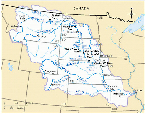
FIGURE 1-1 Missouri River basin, major tributary streams, and mainstem dam and reservoirs. © International Mapping Associates.
opment along tributary streams and for irrigation. In addition, private entities and the U.S. Department of Agriculture (USDA) built dams of different sizes on the tributaries further, affecting water flow and sediment transport. Also, the USDA and the states encouraged private landowners to implement practices that would hold water and sediments on their farms and ranches.
In the 1945 Rivers and Harbors Act, Congress authorized the Missouri River Bank Stabilization and Navigation Project (BSNP). This act resulted in channelization of most of the Missouri River below Sioux City, Iowa—a process that had begun in the nineteenth century—via a combination of dikes, revetments, and other engineering structures. Today, the dams and bank stabilization projects are maintained and operated by the Corps, Reclamation, and other entities. Management objectives of the system are hydropower generation, recreation within the pools and in reaches between the structures, reliable municipal and irrigation water supplies, fish and wildlife, and maintenance of a commercial navigation channel. In the process of impounding and channelizing the Missouri River, the Pick-Sloan dams and the BSNP projects have provided numerous economic and social
benefits. Implementation of these projects has also had extensive and lasting implications for the river’s hydrologic, sedimentary, and ecological systems.
As the Missouri’s hydrologic regime became increasingly controlled, the river basin’s sediment regime—including the processes of sediment erosion, transport, and deposition—also was changed dramatically. Active migration of the Missouri River channel and the recycling of its floodplain largely ceased, and the Missouri’s chutes and sloughs, islands and sandbars, oxbow lakes, and backwater areas went from being dominant to remnant features of the landscape. Many of the native species that had adapted to that river and floodplain, and its aquatic and terrestrial habitats were reduced in population, with some listed as threatened and endangered species.
In addition, the historic volumes of sediment formerly transported downstream by the Missouri River were dramatically reduced. At the river’s mouth near St. Louis, the preregulation Missouri River delivered large amounts of sediment into the Mississippi River that were transported farther downstream and that eventually contributed to deltaic sedimentary processes in coastal Louisiana. Today that sediment supply delivered to the mouth of the river has been reduced to one-third or less of its former volume (Meade and Moody, 2009).
Changes to the river’s sediment regime initiated by the mainstem dams and bank stabilization and channelization projects have had a variety of impacts. For example, the river channel immediately downstream of both mainstem and tributary dams has degraded and lowered because of erosive forces of clear-water releases from the dams. Lowered riverbed elevations downstream of the dams in heavily used recreational areas are a matter of concern for river users. There also are threats associated with lowered riverbed elevations, as this may undercut flood protection works, municipal intakes, and bridges across the mainstem river and tributaries (these latter problems are all seen in and near Kansas City, for example). Of particular note is that three native fish and bird species on the Missouri mainstem—the pallid sturgeon, the least tern, and the piping plover—are today listed under the federal Endangered Species Act as threatened or endangered (USFWS, 2000). The declines of these species have been attributed to the river engineering projects that created a colder, deeper, and less turbid river, and to the loss of large areas of sandbar habitat.
The Corps of Engineers has recognized and taken actions to address the adverse consequences of river development on these three species, in compliance with the terms of a Biological Opinion of 2000 (and amended in 2003) issued by the U.S. Fish and Wildlife Service (FWS) under its Endangered Species Act (ESA) responsibilities (USFWS, 2000, 2003). The expectations of the Biological Opinion have made sediment management a focus of attention since 1989 when consultation began between the FWS and the Corps. The Biologic Opinion of 2000 and the 2003 amendment identi-
fied alternatives and measures to prevent species extinction and included requirements to construct shallow water habitat to improve conditions for the pallid sturgeon and to build emergent sandbar habitat to benefit the two listed bird species. Habitat creation targets in the 2000/03 Biological Opinion were defined as acres of habitat created by these construction activities.
The Corps’ habitat construction activities, however, met with resistance—specifically, in Missouri—where it was argued that discharging sediment into the river as the habitat was being constructed violated federal and state water pollution control laws (these topics are discussed in greater detail in Chapter 3). It also was argued that adverse effects of such discharges on water quality may be felt not only locally, but also far downstream in the Gulf of Mexico. The Corps argued for the need to restore a portion of the river’s sediment regimes and cited the authority of the Biological Opinion. Meanwhile, in this historically sediment-rich river, additional sediment might not only support the recovery of native species, but also reduce the extent of channel bed lowering, and partially restore sediment supply delivered to coastal Louisiana.
Increasing attention to sediment management along the Missouri River and the associated conflicts, demands understanding of river hydraulics and geomorphic processes, relationships between physical responses and habitat quality, and the relationship of sediment management to water quality in a formerly sediment-rich river such as the Missouri. Presently, most direct sediment management responsibilities on the Missouri River mainstem lie with the U.S. Army Corps of Engineers, under the agency’s flood control and navigation authorities, and its responsibilities for habitat loss mitigation.
In 2008, to provide independent advice on Missouri River sediment and related resource management decisions, the Corps of Engineers requested that the National Research Council (NRC) Water Science and Technology Board (WSTB) convene an expert committee to address seven sediment-related questions for the Missouri River system. In response to that request, the NRC appointed the Committee on Missouri River Recovery and Associated Sediment Management Issues. (Box 1-1 contains the committee’s full statement of task.) The breadth of the task statement required this committee to assume a broad and long-term perspective on sedimentary processes in the Missouri River and how they have changed over time. Discussion and explanation of the sediment regime of the Missouri River, how it has changed over time, and its roles in many river management decisions, are central themes of this report. Those discussions relate to several parts of this report, including the role of sediments in Gulf of Mexico hypoxia (task 2), land building in the Gulf (task 3), Missouri River water quality (task 4), species recovery and bed lowering (task 5), and future management actions (tasks 6 and 7).
|
BOX 1-1 Committee on Missouri River Recovery and Associated Sediment Management Issues Statement of Task
|
This report provides information and recommendations of interest to a broad audience, including several federal agencies—namely, the Corps of Engineers, the FWS, and the U.S. Geological Survey; the U.S. Congress and congressional staff members; Missouri River basin state governments and citizens; nongovernmental organizations; Missouri River communities and citizens, commercial sectors, such as navigation and recreation; and river science and management experts from academia, the private sector, and elsewhere.
Responses to the questions posed in this report’s statement of task about sediment management and nutrient loadings into the river system are not based solely in science or engineering. Rather, they also are grounded within a larger context that includes federal and state water laws and acts, governmental decision-making processes, and the history of settlement and economic development along the river. Therefore, in addition to the science of Missouri River sediment dynamics and ecology, this report discusses, for example, authorizations for Corps of Engineers dam and bank stabilization projects, federal laws (e.g., the Clean Water Act and ESA) that relate to sediment management actions, and organizations with decision-making responsibilities for sediment and related resources.
There is considerable overlap among the seven topic areas presented in the statement of task to this committee. It was neither practical nor efficient to arrange the report chapters according to that list. The resulting sequence of chapters addresses those seven tasks, but does not correspond directly to the questions defined in the statement of task.
Chapter 2 addresses topics of Missouri River sediment, the setting and history of the river, and sediment-related processes. It addresses questions 1 and 5—the significance of sediment, and consequences of a lack of sediment.
Chapter 3 discusses the governance structure—laws, authorities, and institutions—for Missouri River management. It provides background on organizations and river management initiatives that are referred to in subsequent chapters and offers advice for improving Missouri River recovery and management actions.
Chapter 4 discusses the consequences for ecosystems and species of various sediment management actions. It addresses question 7—Corps of Engineers Missouri River restoration strategies.
Chapter 5 discusses implications to the river’s sediment regimes of various sediment management actions. It addresses questions 3 and 6—sediment management alternatives, and constraints and prospects for improvement.
Chapter 6 discusses Missouri River water quality and sediment. It addresses questions 2 and 4—effects of sediment management on Gulf hypoxia, and the challenges of designing a water quality management system for a river like the Missouri mainstem.
Chapter 7 is a short epilogue that presents some observations regarding science and decision making for Missouri River sediment and related resources.


