
![]()
USGS Historical International Engagement: Background Paper
The statement of task for this study calls for a background paper to be prepared in collaboration with the USGS. This background paper provides a summary of past and present USGS international scientific interactions and collaborations. It has been prepared by the USGS International Programs Office and has been reviewed by the USGS Bureau International Committee (BIC), but it is not an official document of the USGS.
THIS DOCUMENT IS IN REVIEW AND HAS NOT RECEIVED THE DIRECTOR’S APPROVAL FOR RELEASE AND IS SUBJECT TO CHANGE
PREFACE
The National Academies, through its Board on Earth Sciences and Resources, have been funded by USGS to examine: “Opportunities and Challenges for International Science at the U.S, Geological Survey (USGS).” The Statement of Work for this study calls for a background paper to be prepared in collaboration with the USGS. This background paper is a summary of past and present USGS international scientific interactions and collaborations. Its purpose is to assist the NAS study committee in its deliberations.
This background paper has been prepared by the USGS International Programs Office and has been reviewed by the USGS Bureau International Committee (BIC), but is not an official document of the USGS.
EXECUTIVE SUMMARY
The role of the USGS in the international arena has evolved over its 131-year existence. These changes have been influenced by changing national priorities, the available of funding, changing USGS expertise, and the evolution of foreign policy. However, throughout its
history, the USGS has remained unique among the world’s earth science agencies in terms of its size and breadth of expertise. No other geological survey has the ecosystem and satellite missions of the USGS and few have national responsibility for both geology and hydrology.
The USGS and its partners in the Federal Government have examined the role of the USGS in the international arena before. The salient aspects of these previous studies are discussed in the pages that follow and in Annex 2. More recently, in 2010, the USGS has been reorganized to emphasize its commitment to multidisciplinary science. In so doing, the USGS established offices for six science “mission areas,” including: climate; ecosystems; natural hazards; minerals, energy and health; water; and core sciences including mapping. These recent changes make this an appropriate time for the USGS to make an objective assessment of how the USGS can best serve the interests of the United States in the international arena.
This background paper is a summary of past and present USGS international scientific interactions and collaborations. It documents the early years of USGS international engagement, the rapid growth of USGS international work in the years following WW II, and the recent changes within the last decade as the USGS has increasingly emphasized multidisciplinary work and has grappled with post 9/11-related changes. The paper cites a number of different USGS international activities, not as a comprehensive discussion of USGS work, but as examples of the breadth and depth of USGS international efforts. Finally, this paper examines some of the critical issues that will influence the future of USGS international activities.
This background paper has been prepared to assist the National Academy of Sciences committee regarding the study on “Opportunities and challenges for international science at the U.S. Geological Survey,” USGS looks forward to the committee deliberations and its recommendations and final report.
INTRODUCTION
At irregular intervals over the 131-year history of the U.S. Geological Survey (USGS), various efforts have been made to take stock of USGS’ unique scientific and technical capabilities and to analyze the potential for an increased USGS role in international science and in the Nation’s foreign affairs programs. Over the years studies have been carried out by the USGS, the U.S. Department of State, and the National Academy of Sciences (DOS and USGS 1983; NRC, 1987; NRC, 2001). The results of these studies have been fairly consistent: they recognize USGS’ unique contributions and capabilities, encourage a larger international role for the USGS, and acknowledge the financial, legal and political constraints on the growth of USGS’ international activities.
A new study is being undertaken by the National Academy of Sciences in the 21st century, with a new USGS Director, Dr. Marcia McNutt, a new science strategy (USGS,
2007), a recent realignment of the USGS under “mission areas” and a vastly changed geopolitical scene. Global science issues such as climate and global change, invasive species, food shortages, emerging diseases, changing ecosystems, biodiversity energy and mineral resources, natural hazards, and water quantity and quality are all of great concern today, and are examples where USGS science is involved internationally. In addition, more than any time in recent memory, there exists at this time a heightened expectation of the potential for science diplomacy to inform foreign policy and contribute towards world peace and mutual understanding around the globe. It is increasingly important that global science issues be well understood before proceeding with foreign policy development, and the USGS is playing an increasing role in advising the Department of State about global science issues. This paper presents a historical summary of the USGS international activities and some of the critical issues the USGS is currently confronting. This background paper is intended to serves as a starting point in discussing ways that the USGS can become more effective in addressing its priority issues in the international arena.
EARLY USGS INTERNATIONAL HISTORY FROM 1879 THROUGH WORLD WAR II
Beginning 131 years ago, the USGS established itself as a world leader in international earth science, providing training, technical assistance and institution building on both a bilateral and a multilateral basis, to countries around the world. The results of these efforts can be seen in the earth science and hazard monitoring agencies in many Lesser Developed Countries (LDC’s).
The first international efforts of the USGS were quite modest and included:
- 1882, Clarence Dutton conducted volcanic studies in the Kingdom of Hawaii.
- 1884, the USGS began cooperative work on boundary waters with the Geological Survey of Canada.
- 1890, Herbert Wilson studied irrigation in India.
- 1897, Willard Hayes and Arthur Davis assisted the Canal Commission with geological and hydrogeological studies of proposed routes for what would become the Panama Canal.
Before and during World War II, USGS geologists, hydrologists and cartographers assisted in the war effort by identifying sources of water for military installations, identifying strategic mineral reserves, and compiling maps and charts of strategic international locations. In 1942, a Military Geology Unit (MGU) was started within the USGS, employing approximately 100 scientists fully funded by the U.S. Army Corps of Engineers. This unit was later transformed into the Military Geology Branch. Much of this Branch’s work was
international in nature and involved the preparation of hand layered (geologic, hydrologic, lithologic and botanical) maps.
POST WW II THROUGH 1995 USGS INTERNATIONAL HISTORY
In the post WW II era, the USGS continued to expand its international engagement. However, organizationally, the USGS conducted this work from separate international offices that were administratively housed within the Geology, Mapping, and Water Divisions. Significant activities included country specific work such as the following.
Brazil The USGS began new, significant, long-term international technical assistance programs in Brazil involving 180 temporary duty assignments over 35 years.
Saudi Arabia One of the longest and most successful USGS international activities involved hydrologic and geologic work in Saudi Arabia. This program extended over 40 years, involved over 200 long-term, and more than 400 temporary, duty assignments, and resulted in the establishment of the Saudi Geological Survey (Worl, 2003).
Pakistan In the 1950’s, the USGS began a technical assistance program in Pakistan that included stationing hydrogeologists in country for several years to collaborate on groundwater resource assessments. This work led to the creation of the Geologic Survey of Pakistan.
During this period the USGS continued international work through its Military Geology Branch. It made notable Cold War era contribution in the use of seismic monitoring to assist the Defense Intelligence Agency and other federal agencies to detect nuclear weapons testing around the world.
Also in the 1950s, the USGS Mapping Division began the Antarctic Research Program, which continues to this day in close cooperation with the National Science Foundation (NSF).
During the post WW II period, training became an increasing part of USGS international work. Between 1943 and 1963, more than 600 foreign geologists were trained by USGS staff, while thousands of others were trained in cartography and hydrology. Additionally, in the 1960s the USGS, in cooperation with NASA, began an Astrogeology Branch in Flagstaff, AZ. That Branch trained astronauts for lunar missions and the USGS was placed in charge of handling and testing the rock samples retrieved from the moon. Beginning in 1963, the International Water Resources Branch coordinated the training of thousands of foreign visitors, primarily through the Techniques of Hydrologic Investigations for International Participants (THIP) program.
This period also saw a dramatic rise in USGS engagement with international organizations.
In 1973, the USGS co-founded the Circum Pacific Council (CPC), a non-profit international organization of Earth Scientists and Engineers that continues to this day to develop and promote research and cooperation among industry, government and academia for the sustainable utilization of earth resources in the Pacific Region. The USGS also began its involvement with UNESCO’s International Geological Correlation Program (IGCP), a program which has been critical in bringing USGS specialists in contact with similar specialists from around the world. In 1991, the USGS partnered with UNESCO to develop the Reduction of Earthquake Losses in the Extended Mediterranean Region (RELEMR) program. This program engages Middle East Countries by using seismology and a common interest in reducing earthquake hazards as a means to bridge political difference and promote regional cooperation.
Additionally, in 1991, the USGS partnered with the United Nations Environmental Program (UNEP), resulting in the USGS hosting the North American Node of its Global Resource Information Database (GRID) at the USGS Earth Resources Observation and Science (EROS) Center in Sioux Falls, South Dakota (see Figure C.1). This is the only UN office in the United States outside of New York and Washington (see figure showing current world offices of UNEP GRID). Today the USGS has played a major role in the popular UNEP publications—“One Planet Many People: Atlas of our Changing Planet”, and “Africa Atlas of our Changing Environment”. The USGS is also supporting a planned
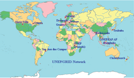
FIGURE C.1 Location of all UNEP GRID Centers. SOURCE: USGS.
UN Educational, Scientific, and Cultural Organization (UNESCO) atlas illustrating the use of remote sensing to monitor endangered World Heritage Sites.
The USGS leadership in remote sensing and land characterization took a big step forward in 1966 when it worked with the National Aeronautics and Space Administration (NASA) and other U.S. agencies to provide continuous global coverage of the land surfaces of the Earth. Since 1972, the United States has flown Landsat satellites that have ably served the economic, security, and environmental interests of the United States and its foreign partners. Recently, the 2010 U.S. National Space Policy confirmed USGS leadership role for future land imaging, and directed the USGS, NASA, OSTP, and OMB to develop plans and procedures to maintain continuity of land imaging satellite observations. Today, the USGS owns and operates the Landsat system, and provides open and free access to the entire Landsat archives, where over 4 million scenes have been downloaded and provided to some 184 countries around the world (see Figure C.2 and Figure C.3). To maintain the global archives, 14 Landsat ground stations are operated by a network of International Cooperators that are members the international Landsat Ground Station Operators Working Group managed by the USGS.
In 1985, the USGS began the Volcano Disaster Assistance Program (VDAP) in cooperation with USAID’s Office of Foreign Disaster Assistance (OFDA). VDAP provides training and technical assistance for volcano monitoring agencies in Lesser Developed Countries. This program has saved thousands of lives and many millions of dollars in property. One of its most notable successes was the 1991 early warnings of the pending
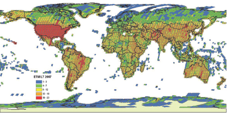
FIGURE C.2 Landsat 7 provides unique systematic coverage of the global land surface on a seasonal basis via a long-term acquisition plan (LTAP). The legend shows the number of scenes collected over each land area. SOURCE: USGS.
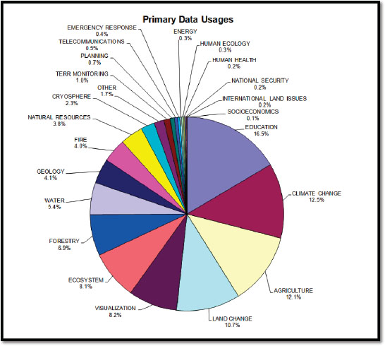
FIGURE C.3 User reported primary use of Landsat data. SOURCE: USGS.
eruption of Mt. Pinatubo, thus enabling the evacuation of Clark Air Base in the Philippines and the saving of hundreds of lives and hundreds of millions of dollars in aircraft and related equipment.
Recent (Post 1995) Developments at the USGS
In the decade of the nineties, the USGS continued to expand its international engagement. In 1995, the Office of International Geology became a Bureau-level International Programs Office, called the International Programs Office, under the Associate Director for Geology. During this same time period, the USGS established the Biological Resources Division (BRD) as a result of reorganization in the Department of the Interior. From this time forward, the USGS international dimension was concerned with the science disciplines
of geology, geography, water, and biology. The following is an accounting of a few of the notable international efforts from 1995 to date.
Traditional Engagements
Post 1995 the USGS has continued, and expanded, many of its traditional areas of international engagements. Often these are in support of, and funded by, USAID. Examples of these efforts include:
FEWS: The USGS is continuing its highly successful involvement in the more than 25 years old Famine Early Warning System (FEWS) program. This program is able to detect impending drought situations 3 month in advance of crop failures, thus providing assistance agencies time to prepare an emergency response. Originally deployed in a few countries in Africa, this very successful program is used throughout Africa and Asia and was one of the first development tools used by the U.S. in Afghanistan.
USAID/OFDA: Supported by USAID’s Office of Foreign Disaster Assistance (OFDA), the USGS has responded to disasters such as the December 2002 tsunami, the recent Haiti earthquake, the eruption of Chiatin volcano in Chile, and volcanic eruptions in Kenya. Similarly, OFDA has supported USGS development of the PAGER system, a system that rapidly locates significant earthquakes, estimates their magnitude, estimates the intensity of ground shaking, estimates the amount of infrastructure and numbers of people likely to have been subjected to strong shaking, and then makes a preliminary evaluation of damage and loss of life. PAGER has been repeatedly used by first responders to prioritize their relief efforts. Finally, after the South Asian Tsunami of 2004, OFDA provided funds that allowed the USGS to install a Caribbean Tsunami Warning System to help protect the Caribbean region.
Hurricane Mitch support: In 1998, with the support of USAID, the USGS launched one of its first interdisciplinary efforts in the international arena. The successful Hurricane Mitch Project involved USGS staff from the Geography, Geology and Water Divisions, working together in four Central American nations under a USAID financed disaster recovery program. USGS was one of the many Federal agencies which joined together to from the “Hurricane Mitch Reconstruction Task Force”, designed to provide aid and assistance to the affected Central American countries. Resulting efforts, including training in GIS, remote sensing application, coupled with The Treaty on Open Skies, produced photographs and imagery to reveal detailed information about natural and man- made structures for in-country decision makers.
International Wetlands Research and Observation: As part of the State Department’s Lower Mekong Initiative, the USGS Delta Research and Global Observation Network
(DRAGON) partnership is using its experience with the Mississippi River and its expertise in earth science modeling to help the Mekong countries assess how climate change and human activities could impact the ecology and food security of the Mekong basin. Despite a geographic difference of twelve time zones, there are many cultural, economic and ecological similarities between the Mississippi and Mekong River Deltas. DRAGON has created an international community of practice among scientists and resource managers to share data on the great deltas and rivers of the world. The Forecast Mekong project, a component of the DRAGON partnership, will continue moving forward with building the foundation for later activities through strengthening relationships with Mekong region scientists and organizations, data sharing and joint research.
USGS Funded International Missions
As previously noted, as an agency within the Department of Interior, the USGS mostly engages in domestic work. In large measure the budgets of USGS are directed nationally. However, there are some notable exceptions where the USGS is funded out of its budget to work internationally in order to be more effective domestically. Three examples are of note.
Global Seismic Network: The USGS is an active partner in setting up and operating the Global Seismic Network (Figure C.4), a system which monitors earthquakes around the world.
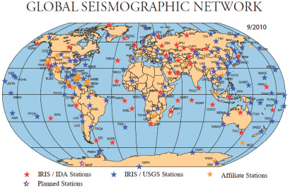
FIGURE C.4 The Global Seismic Network. SOURCE: USGS.
World Petroleum Assessment Program: Energy resources are critical to our Nation’s future. The USGS World Petroleum Assessment program is an ongoing activity to estimate total petroleum resources and identify new targets for exploration.
Global Mineral Resource Assessment Project: mineral resources are also of National importance and the USGS Global Mineral Resource Assessment Project attempts to assess the global availability of selected critical minerals while the USGS minerals information team tracks the global supply and demand for virtually all minerals commodities. An example is provided as USGS (2010). As Figure C.5 shows, the U.S. is heavily reliant on imports for most minerals and such information is critical for anticipating and responding to minerals shortages. China’s recent restriction on exports of rare earth elements, materials that are critical for manufacturing of many high tech products, highlights the need for this information.
Global Wildlife Disease News Map: The USGS has created the Global Wildlife Disease News Map (see Figure C.6), which displays news articles from the Wildlife Disease News Digest.1 On it users can easily see wildlife disease headlines both locally and globally. The Map displays Wildlife Disease News Digest articles that have been posted within the last 45 days that have a geographical reference. The complete collection of articles, going back to December 2005, can be found on the online Digest.2 With no global surveillance system in existence for the monitoring of wildlife health, this tool helps to fill the void by harvesting unstructured, disparate information about disease outbreaks and other wildlife related topics. Not only supplied for the wildlife professional, the information is directly applicable to those who study diseases of concern for livestock, domestic animals, and human health.
Invasive Species: Invasive species represent a serious threat to many vital U.S. interests, including the livelihood of commercial fishermen, the danger to threatened species and sensitive habitats, and the importation of wildlife and human disease agents. By definition, invasive species have entered the U.S. from other countries, and to understand their biology and thus mitigate the damage they cause, it is essential to work collaboratively with foreign researchers. USGS scientists study the life cycle of the non-native Asian carp to better understand how to manage this invasive species in the Missouri River. Asian carp were introduced into the United States for use in aquaculture production of food fishes, and biological control of plankton in aquaculture ponds and sewage treatment lagoons. The carp escaped confinement, however, and spread to the waters of the Mississippi River basin and other large rivers. Today, the carp live in 23 states; their population numbers
__________________
1 See wildlifedisease.nbii.gov/wdinNewsDigestMap.jsp.
2 See wdin.blogspot.com.
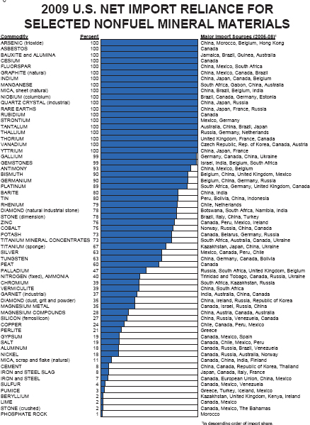
FIGURE C.5 2009 U.S. net import reliance for selected nonfuel mineral materials. SOURCE: USGS.
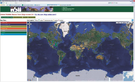
FIGURE C.6 Global Wildlife Disease News Map. SOURCE: USGS.
increasing exponentially, and they are close to entering the Great Lakes. Nutria are invasive semiaquatic rodents whose populations in the United States have become so large that their marsh habitats often cannot sustain them, or our native species. USGS has developed and continues to improve tools to assess nutria population densities, movements and life history characteristics. Such tools can lead to ecological forecasting models, enabling a proactive response to reduce their harmful impacts.
USGS Center of Excellence: The USGS has several Centers of Excellence around the U.S. that have played a role in various international efforts and could play a larger role in the future. The Antarctic Resource Center in Reston, VA has hosted international explorers and researchers for decades. It has evolved into a Polar Center and could be a great asset to climate change researchers. The National Wetlands Research Center in Lafayette, Louisiana has hosted wetlands managers from around the world. The National Earthquake Information Center (NEIC) in Golden, Colorado hosts international seismic experts on a regular basis (see Figure C.7). The National Wildlife Health Center in Madison, Wisconsin is a world-class facility that conducts research on wildlife diseases, including those that affect human health. The USGS EROS facility in Sioux Falls, South Dakota hosts the World Data Center for medium resolution satellite imagery, the UNEP GRID North American
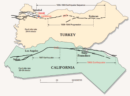
FIGURE C.7 The striking resemblance between the San Andreas and North Anatolian faults suggests that understanding one fault may help to understand the other. SOURCE: Ross S. Stein, USGS (2000a).
office, and conducts remote sensing and geographic information training for geographers from developing countries. Most of these facilities are collocated with a university.
Finally, many USGS scientists are leaders in their area of specialization. As such they are an important part of a global community of scientists and their profession demands that they engage internationally both in their research and in their communications and collaborations.
USGS Support to Department of Defense
The post 9/11 era has seen an increased emphasis on national security issues. The USGS, as have many Federal Agencies, has responded to this change. A result has been an increase in USGS partnership with both the Department of Defense and Department of State. The following are some examples of this increase:
Afghanistan: Since 2002, the USGS has had a significant program in Afghanistan, including a more than 2 year long assignment of a resident advisor at the U.S. embassy in Kabul. With funding from USAID and, more recently, DOD, the USGS has conducted interdisciplinary studies of energy, mineral, and water resources, hazard assessments, and capacity building (Peters et al., 2007). These assessments are intended to promote Afghanistan’s use of its natural resources and to stimulate its sustainable economic development. One result of these efforts is the recently released evaluations of Afghanistan’s mineral resource potential, work that shows that large mineral deposits are likely to be present (Figure C.8). In evaluating this work, one Deputy Undersecretary of Defense noted that, “The USGS work has fundamentally changed the discussion of how Afghanistan might economically develop.”
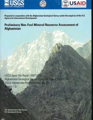
FIGURE C.8 USGS preliminary mineral resource assessment of Afghanistan. SOURCE: USGS.
Iraq: In 2009, the USGS executed an intense, year-long effort to evaluate Iraq’s mineral and water resources, while also providing capacity building in the geological and hydrological sciences. One result of this training and new instrumentation is that Iraq can now directly monitor the snow fall and water resources outside of its borders and thus is in a stronger position to discuss trans-boundary water issues with its neighbors.
Additional support to DOD Commands: The USGS continues to cooperate with DOD in a number of other areas. It has a full time employee in Colorado serving as a liaison with the Northern Command (NORTHCOM). It has cooperated in a series of training exercises with the Southern Command (SOUTHCOM). As noted above it has been active in its support of the Central Command (CENTCOM) with work in Afghanistan and Iraq. Currently, the USGS is also working with the recently established African Command (AFRICOM) to detail a USGS scientist to Stuttgart, Germany to support AFRICOM’s “soft power” agenda in Africa.
Department of State Support
In the post 9/11 world, the U.S. Department of State has placed renewed emphasis on science diplomacy. President Obama’s Cairo speech is one example of this. Not surprisingly, the Department of State has repeatedly recognized the USGS as one of its most important partners in its science diplomacy efforts. The Department of State’s Bureau of Oceans, Environment, and Science (OES) is one of the principal groups with which the USGS engages. Recently, OES identified its 5 priority topics. In order, these are:
- Climate Change
- Science Diplomacy
- Global Health
- Water and Sanitation
- Environmental Protection
- Clean, Safe, Secure Oceans and Polar Regions
- Sustainable Natural Resource Management
There is clearly significant overlap between these priorities and the new USGS restructuring into mission areas (see discussion of Organization Structure above; also note that OES priorities that closely match USGS mission areas are marked in bold text.)
Although “science diplomacy” is not a USGS mission, many of the USGS international scientific activities clearly support diplomatic objectives. A previously cited example is USGS leadership of the RELEMR program which uses earthquakes to bring Middle East countries together. Similarly, USGS leadership of the Middle East EXACT program used
common interests in water resources to bring Israel together with Jordan and the Palestinian Authority to discuss water resource concerns. Both efforts were funded by the Department of State as part of its Middle East Peace Process. Science diplomacy efforts are becoming increasingly important and one may reasonably expect them to become a larger part of USGS’ international activities.
Embassy Science Fellows Program: The USGS is an important participant in the State Department’s Embassy Science Fellows (ESF) program, which began in 2002. Participants in the program are detailed to an embassy, consulate, or cooperating host country institution for a short period of time to address a particular issue or problem. Most Embassy Science Fellows are assigned 1-3 months at post. Because the embassy only provides office space and some housing, the main cost of the program is borne by the USGS. This cost has limited USGS participation to only one to three scientists per year.
Conflict Diamonds: In response to the Department of State’s support of the Kimberley Process, an effort to reduce the trade in “Conflict” diamonds, the USGS has performed a number of geologically based diamond production capacity assessments and capacity building work in Liberia, Ghana, the CAR, Mali, and Guinea.
Muslim Majority Countries: In 2009 President Obama gave a speech in Cairo which emphasized the importance of U.S. science and technology engagement with Muslim Majority countries. Subsequently, the USGS has been actively supporting the President’s position with S&T engagements in Kuwait, UAE, Saudi Arabia, and Indonesia.
USGS Organizational Outreach and Support
Since 1995, USGS engagements with international organizations have significantly expanded. The USGS continued its outreach efforts by providing scientists to a wide variety of organizations, and included many opportunities to lead development of international science plans and standards.
The USGS has a long history of support for UNESCO. This support continued, even during the period when the U.S. was not a UNESCO member, and has included direct support for UNESCO’s Intergovernmental Oceanographic Commission (IOC) activities and the previously mentioned USGS/UNESCO RELEMR program. Now the United States is fully engaged in UNESCO and the USGS continues to provide U.S. leadership to UNESCO International Hydrological Programme (IHP), UNESCO International Geological Correlation Program (IGCP), and the UNESCO Category II Center (the International Center for Integrated Water Resources Management) that is to be established in the United States. Finally, the U.S. Ambassador to the U.S. Mission to UNESCO has recently
requested a USGS detailee to support the U.S. science agenda at UNESCO headquarters in Paris, France.
The USGS has been active in carrying out cooperative trainings and studies with a variety of other UN organizations (UNDP, IAEA, FAO, and the World Meteorological Organization, WMO). These have provided multiple benefits as well as the ability to interact with scientists from countries that do not have diplomatic relations with the United States.
The USGS has also been a leader or cooperator with several smaller earth science organizations, including CCOP, CPC, OAS, SOPAC, PAIGH, and Eurogeosurveys (see list of acronyms in Annex 3). The USGS also has a special relationship with some of the more established bilateral and multilateral earth science organizations. Collaborative research, sharing of equipment and reciprocal visits of scientists are common with these comparable agencies, including BGR (Germany), BGS (UK), BRGM (France), GA (Australia), GSC (Canada), Environment Canada, and National Institute of Water and Atmospheric Research Limited (New Zealand).
The USGS has leadership roles in efforts to promote Geospatial Data Infrastructure (GSDI), Global Biological Information Facility (GBIF), the International Union of Geological Sciences (IUGS), the Inter-American Biodiversity Information Network (IABIN), the Global Invasive Species Information Network (GISIN), and the hydrology program at the WMO. Traditionally, at least two USGS staffers are members of the National Academy of Sciences’ National Committee for Geological Sciences.
Another highly successful USGS engagement has involved the Group on Earth Observation (GEO), the Committee on Earth Observation Satellites (CEOS), and efforts to implement the Global Earth Observation System of Systems (GEOSS). USGS leadership in these efforts started in 2003 and continues to the present day. As an example, the USGS just participated in the Earth Observation Summit in Beijing in November 2010. The USGS provides critical resources for GEO, such as maintaining the global clearinghouse for remote sensing and geospatial data, and participation in the agriculture, climate, disasters, ecosystems and energy societal benefit areas. More than 80 percent of the imagery for the GEO project on Global Land-Cover Data Initiative can be obtained from USGS Landsat missions. In addition, for the past three years, the USGS has funded an employee in Geneva to serve on the GEO Secretariat.
The USGS has also played a key role in the International Charter for Space and Natural Disasters. Since 2005, this effort has involved 19 agencies that have worked to provide a unified system to acquire remote sensing imagery and to delivery those images to areas affected by natural or man-made disasters. The USGS participates in the Charter insures that it receives foreign remote sensing data in support of U.S. disaster response and recovery efforts. In turn, the USGS involvement ensures provision of U.S. land imaging data to support foreign disaster response and recovery efforts.
Future Directions and Challenges
USGS international work has a long and distinguished history. From its beginning in 1882 through the post World War II era, the USGS international work supported its domestic research priorities as well as provided support to many developing countries. During World War II, the Military geology branch played a role in supporting the Nation’s security and foreign policy. In the post 9/11 world, USGS international work has increasingly emphasized issues associated with national security and support for U.S. foreign policy. At the same time, USGS international work has also increasingly emphasized multi-disciplinary science, an emphasis that reflects organizational changes within the USGS. The transfer of USGS International Programs into the Director’s office in 2010 emphasizes the USGS commitment to have International Programs represent all of the USGS science capability and its six “mission” areas.
Although the USGS is part of a domestically oriented Department of the Interior (DOI), the scientific research it conducts is not limited by international, political boundaries. The USGS has long recognized the mutual benefits that ensue from interaction with scientific colleagues overseas. Such interactions contribute to a better understanding of earth and life science issues here in the United States. In addition, there are many scientific issues, such as invasive species and climate change, which can only be dealt with on an international scale. For example, significant lessons have been learned about the San Andreas Fault in California by studying the similar Anatolian Fault in Turkey. As described in 2000 by the Science Priorities Team for International Activities, “In a world that increasingly recognizes that the earth is a system, the USGS has a unique opportunity and responsibility to provide global scientific leadership” (USGS, 2000b).
The international activities of the USGS continue to evolve to meet other National needs. Often this work is in support of USAID’s foreign assistance efforts, work that almost invariably incorporates training, technical assistance and institution building. Increasingly, USGS international efforts have had and will continue to have an element of support for U.S. foreign policy. The most recent example is the DOS effort to promote S&T engagement with Muslim-Majority Countries. The USGS has a more than 50-year record of successful S&T engagement with the Islamic world, work that includes cooperative projects with Afghanistan, Bangladesh, Indonesia, Pakistan, Saudi Arabia, and the United Arab Emirates. Most recently, the USGS has worked with DOD in a number of efforts to promote regional stability and economic growth.
The new USGS reorganization makes this an excellent time to review past USGS international engagements and contemplate what changes might be made to support and strategize future USGS international science. In making these evaluations, it will be critical to consider the role of international work in supporting the USGS core responsibilities as a domestically focused agency that is committed to multi-disciplinary science. It will also be
critical to consider the increasing demands that other organizations, such as the Department of State, USAID, and the Department of Defense, are making of the USGS in support of foreign development, international diplomacy, and National security. In that connection, it may be useful to balance an idealistic vision with realistic constraints posed by limited and uncertain funding and restricted legal authorities for international work (USGS, 2005). The USGS looks forward to the NAS findings and recommendations as a critical part in developing a new international strategic plan and engagement strategy.
ANNEX 1
USGS INTERNATIONAL PROGRAM OFFICE
In 1995, the Office of International Geology became a Bureau-level International Programs Office under the Associate Director for Geology. During this same time period, the USGS established the Biological Resources Division (BRD). BRD was formed at the behest of Secretary of Interior Babbitt who transferred most of the research biologists from the various Bureaus of DOI into this new USGS Division. The result of these changes was that International Programs assumed responsibility for representing all USGS scientific disciplines (geology, hydrology, cartography, and biology) in the international arena.
Further changes occurred in 2010, at which time the USGS completed an internal reorganization that moved it from a discipline focused (geology, water, mapping, biology) Agency, to one focused in the application of integrated science in support of critical “mission areas”. The scientifically focused mission areas are:
- Ecosystems
- Climate and Land-Use Change
- Energy and Minerals, and Environmental Health
- Natural Hazards
- Water
- Core Science Systems
An additional result of this change was that International Programs was administratively placed directly under the Director of the USGS. As a Bureau-level function, International Programs is supported by contribution from all of the USGS mission areas.
Although the USGS structure has changed, International Programs Office remains charged with representing USGS interests and capabilities in the international arena. New emphasis is placed on the broader USGS interest in pursuing integrated science in support of all of its critical mission areas.
To accomplish this, International Programs Office has five regional specialists whose primary jobs are to represent USGS interest and coordinate USGS activities around the globe. The five regions covered by these specialists are:
- Europe and the Former Soviet Union
- Africa and the Middle East
- Asia and the Pacific
- Latin America and the Caribbean
- Canada, the Arctic, and the Antarctic
In practice, these specialists have extremely diverse tasks which include support of USGS scientists engaged in international work, representing USGS to organizations such as USAID, Department of State, Department of Defense, and the World Bank, and developing contacts and programs in the countries that are part of their region. A number of programs and activities developed and coordinated by these specialists are discussed in this background paper/
The second group within the International Programs Office is the Bureau Support Unit. Their primary task is to obtain passports, visas, State Department clearances, and other logistical support that is required for USGS international travelers, which amount to over 1000 per year. Additionally, this group processes and maintains the approximately 70 international bilateral agreements which the USGS has in place. Finally, the Bureau Support Unit also is shepherding approximately 30 additional international agreements through the often lengthy approval process.
In 1997, the Bureau International Committee (BIC) was established to support International Programs and to promote closer coordination between IP and the operational scientific parts of the USGS. The BIC makes contributions in two main areas. First, it provides advice used to set Bureau international policy. Second, when needed, it can help to identify the scientific units and scientists that might best respond to an international opportunity. The BIC is now transitioning to include representatives from all the USGS Mission Areas.
ANNEX 2
PREVIOUS USGS INTERNATIONAL REVIEWS
In January 1983 the State Department and the USGS completed a joint report titled “International Role of the U.S. Geological Survey”. This report drew heavily on previous USGS summaries of international activities that were updated about once every decade.
In 2000, the Associate Director for Geology convened a Bureau wide meeting to discuss international science priorities for the USGS. This meeting followed on the heels of the
decision by the Director to consolidate the Bureau’s international activities into a single office under the leadership of Associate Director for Geology. The results of this meeting are summarized in the report, “Science Priorities Team for International Activities” (USGS, 2000b).
In 2001, the National Academy of Science National Research Council published the results of a study “Future Roles and Opportunities for the U.S. Geological Survey”. This study (NRC, 2001), made several references to the potential international role of the USGS and made several recommendations including:
…it is appropriate for the USGS to become more active at international and global levels as well. By playing a strong role on behalf of the U.S. in promoting, facilitating, and conducting international and global studies to develop critical science information, the USGS lends support to national security as well as foreign policy… (p. 52)
Because many science issues today are global and international in nature, the USGS in the 21st century should place high priority on the following:
- Performing a more vigorous role in pursuing foreign area and global studies,
- Providing increased technical assistance to foreign countries,
- Becoming more active internationally. (p. 63)
…the USGS is encouraged to play a stronger international role, on behalf of the United States, in order to accomplish its mission. The Committee believes that the importance to the United States of USGS international activities and collaboration cannot be overstated. (p. 87)
In 2007, the USGS developed its Science Strategy for the coming decade (USGS, 2007). The USGS is implementing the recommendations outlined in this Strategy by realigning its management and budget structure around the six scientific mission areas proposed in the Science Strategy. The six mission areas, which are inherently international or global, include global climate change, water resources, natural hazards, energy and minerals, ecosystems, and data integration.
ANNEX 3
LIST OF ACRONYMS AND ABBREVIATIONS
| AFRICOM | Africa Command, DOD, Stuttgart, Germany |
| ARC | Arctic Resource Center, USGS, Reston, VA |
| BGR | German Geologic Survey |
| BGS | British Geologic Survey |
| BIC | USGS Bureau International Committee |
| BRD | Biological Resources Discipline or Division, USGS |
| BRGM | French Geologic Survey |
| CCOP | Coordinating Committee for Geoscience Programmes in East and Southeast Asia |
| CCP | Circum Pacific Council |
| CEOS | Committee on Earth Observation Satellites |
| CPC | Circum Pacific Council |
| CTWS | Caribbean Tsunami Warning System |
| DOD | Department of Defense |
| DOE | Department of Energy |
| DOI | Department of Interior |
| DOS | Department of State |
| DRAGON | Delta Research and Global Observation Network |
| EDC/EROS | EROS Data Center/Earth Resources Observation and Science Center |
| ESF | Department of State’s Embassy Science Fellows Program |
| FAO | Food & Agriculture Organization of United Nations, Rome |
| FEWS | Famine Early Warning System |
| GA | Geoscience Australia |
| GBIF | Global Biological Information Facility |
| GEO | Group on Earth Observations |
| GEOSS | Global Earth Observation System of Systems |
| GISIN | Global Invasive Species Information Network |
| GRID | Global Resource Information Database |
| GSC | Geological Survey of Canada |
| GSDI | Geospatial Data Infrastructure, USGS |
| GSN | Global Seismic Network |
| IABIN | Inter-American Biodiversity Information Network |
| IAEA | International Atomic Energy Agency, Vienna |
| ICA | International Cooperative Agency |
| IGCP | International Geological Correlation Program (UNESCO) |
| IHP | International Hydrologic Program (UNESCO) |
| IOC | Intergovernmental Oceanographic Commission |
| IOTWS | Indian Ocean Tsunami Warning System |
| IUGS | International Union of Geological Sciences |
| LDC | Lesser Developed Countries |
| MGU | Military Geology Unit, USGS |
| NAS | National Academy of Sciences |
| NASA | National Aeronautics and Space Administration |
| NEIC | USGS National Earthquake Information Center |
| NOAA | National Oceanic and Atmospheric Administration |
| NRC | National Research Council |
| NSF | National Science Foundation |
| OAS | Organization of American States |
| OES | Department of State’s Bureau of Oceans, Environment, and Science |
| OFDA | USAID’s Office of Foreign Disaster Assistance |
| OIG | Office of International Geology |
| OMB | Office of Management and Budget |
| OSTP | Office of Science & Technology Policy, White House |
| PAGER | Prompt Assessment of Global Earthquakes for Response |
| PAIGH | Pan American Institute of Geography and History |
| RELEMR | Reduction of Earthquake Losses in the Extended Mediterranean Region |
| RGEG | USGS’ Research Grade Evaluation Guide |
| S&T | Science and Technology |
| SOPAC | South Pacific Council |
| SPTIA | Science Priorities and Training for International Affairs |
| THIP | Techniques of Hydrologic Investigations for International Participants |
| UAE | United Arab Emirates |
| UNDP | United Nations Development Program |
| UNEP | United Nations Environmental Program |
| UNESCO | United Nations Educational, Scientific and Cultural Organization, Paris |
| USAID | U.S. Agency for International Development (aka “AID”) |
| USGS | United States Geological Survey |
| USTDA | U.S. Trade and Development Agency, Dep’t. Of Commerce |
| VDAP | USAID/USGS Volcano Disaster Assistance Program |
| WMO | United Nations World Meteorological Organization, Geneva |
ANNEX 4
REFERENCES
DOS and USGS (U.S. Department of State and U.S. Geological Survey). 1983. “International Role of the U.S. Geological Survey.” USGS internal document.
NRC (National Research Council). 1987. International Role of U.S. Geoscience. Washington, DC: National Academy Press.
NRC. 2001. Future Roles and Opportunities for the U.S. Geological Survey. Washington, DC: National Academy Press.
Peters, S.G., S.D. Ludington, G.J. Orris, D.M. Sutphin, J.D. Bliss, and J.J. Rytuba (eds.) and the USGS-Afghanistan Ministry of Mines Joint Mineral Resource Assessment Team. 2007. Preliminary Non-Fuel Mineral Resource Assessment of Afghanistan. Open-File Report 2007-1214.
USGS (U.S. Geological Survey). 1976. Historical Review of the International Water-Resources Program of the U.S. Geological Survey 1940-70. USGS Professional Paper 911. Washington, DC: U.S. Government Printing Office.
USGS. 2000a. Implications for Earthquake Risk Reduction in the United States from the Kocaeli, Turkey, Earthquake of August 17, 1999. USGS Circular 1193.
USGS. 2000b. “Science Priorities Team for International Activities” (SPTIA), Denver, CO. USGS internal document.
USGS. 2005. USGS Authorities to Work Outside the National Domain. Available at international.usgs.gov/usgs/travel/user_guide/ex2.html (USGS internal document).
USGS. 2007. Facing Tomorrow’s Challenges: USGS Science in the Decade 2007-2017. USGS Circular 1309. Available at pubs.usgs.gov/circ/2007/1309/.
USGS. 2010. Minerals Commodity Summaries 2010. Available at minerals.usgs.gov/minerals/pubs/mcs/.
USGS (U.S. Geological Survey). No date. Review of the History of USGS Efforts in Support of Geologic and Mineral-Resorce Studies in the Kingdom of Saudi Arabia. USGS Ineternal document.
Worl, R (U.S. Geological Survey). 2003. The U.S. Geological Survey in Saudi Arabia: A Review of the History of USGS Efforts in Support of Geologic and Mineral-Resource Studies in the Kingdom of Saudi Arabia. USGS internal document.


