
![]()
Ongoing International Scientific Activities at the USGS
The U.S. Geological Survey (USGS) is charged by the Department of the Interior (DOI) to respond to evolving national priorities with sound, unbiased scientific advice (DOI, 2011). In approaching its charge, the USGS science strategy recognizes that “the earth behaves as a system in which oceans, atmosphere and land, and the living and nonliving parts therein, are all connected” (Steffen et al., 2004) and the USGS therefore uses a systems approach in a number of its studies. Such an approach is comprehensive in scope and enables the USGS to use the breadth and depth of its strengths, expertise, and capacities to monitor, analyze, and provide better understanding of a range of Earth processes through time.
In support of the systems approach to studying the Earth, the USGS organization comprises seven mission areas that are explicitly cross-cutting, problem-based, and interdisciplinary: (1) Climate and Land-Use Change, (2) Core Science Systems, (3) Ecosystems, (4) Energy and Minerals, (5) Environmental Health, (6) Natural Hazards, and (7) Water (USGS, 2007b; 2011a). These science areas are not isolated disciplines but rather broad domains that interact with one another. This chapter describes the seven mission areas, their core activities and international activities, and the specific benefits and relevance of international activities in these areas for both the USGS mission and U.S. national interests.
Although the mission of the USGS focuses on national resources, international approaches are necessary in at least three situations: (1) when a major resource or ecosystem spans an international boundary, (2) when threats or changes to a resource originate outside U.S. borders, and (3) when information relevant to management or conservation is available only through international collaboration or research.
Some USGS mission areas document a longer history of engagement in international activities due to the existence of their core science domains as part of the USGS structure since the Survey’s inception. For example, international research in areas such as natural hazards, energy and minerals, and water has a long tradition at the Survey, and each of these
areas has a strong basis in mapping. Other areas (e.g., ecosystems, environmental health, and climate science and land-use change) are comparatively younger in terms of concentrated scientific pursuit at the Survey and thus have shorter records of international engagement. These differences are reflected in the historical record of international projects provided to the committee by the USGS (see Appendix C).
The committee interpreted its assignment to include an overview of all USGS mission areas regardless of their historical precedents in international research, and did not consider its charge to include a detailed evaluation of current (or past) international activities. Rather, the committee considered possibilities for new international science opportunities across the entire Survey organization (see Chapter 4) based on a selection of ongoing activities that the committee found to represent the breadth and depth of USGS expertise and experience as outlined in this chapter.
The information in this chapter is based on (1) presentations made to the committee by USGS scientists in each of the mission areas; (2) a document about the Survey’s historical engagement in international activities, prepared by the USGS for the committee’s use (see Appendix C); (3) discussions with Survey scientists; (4) information provided by project sponsors and partners (see Chapter 2); and (5) information that the committee gathered from publications and online resources (e.g., Box 3.1 and elsewhere in the chapter). This chapter does not provide an exhaustive description of all current international projects at the USGS but provides context for the strategic international opportunities identified in Chapter 4. A selected bibliography of peer-reviewed scientific publications written by USGS scientists is compiled in Appendix E for the reader’s interest.
Climate system research examines the Earth’s surface, ecosystems, and hydrosphere, and inherently requires a global perspective. Climate anomalies and patterns develop over scales that transcend political borders, and changing land-use patterns have global causes, feedbacks, and impacts. Thus for climate research, international activities require the capacity to anticipate the impacts of climate on the Earth and its inhabitants, and to suggest strategies for adaptation to and mitigation of ongoing climate change (e.g., NRC, 2010; 2011a).
Mission Area and Core Activities
The current DOI strategic plan charges the USGS with “conduct[ing] reliable scientific research in ecosystems, climate and land use change…to inform effective decision making and planning” and with “lead[ing] the effort on climate change science research for the Department” (DOI, 2011). The plan recognizes the need to engage internationally in this
BOX 3.1
The USGS Web Presence for International Science
The committee had the advantage of becoming well informed about the Survey’s international science activities from a variety of sources both within and external to the USGS. These sources included published literature, personal communication with and presentations from individuals familiar with USGS international work, and information from various parts of the USGS website.
Examination of the USGS website revealed no central listing or description of all of the Survey’s ongoing international projects. Some international information was found through a search on the USGS website for the word “international” or using the “International Activities” link near the bottom of the “About USGS” page. These options lead the viewer to the page for the Office of International Programs (OIP), which has informative descriptions of the OIP and how the USGS conducts its international activities, but no information on the many and diverse international projects themselves.
On the web pages for the individual mission areas, descriptions or mention of international science activities is inconsistent. Some mission areas, such as Energy and Minerals, describe their international activities seamlessly, together with their domestic activities on the mission area’s main page. For other mission areas, international work that the committee knows to be taking place is difficult to find on the mission area’s web pages or elsewhere on the Survey website.
In the same vein, information about publications—whether official USGS reports, fact sheets or other publications, or articles in peer-reviewed journals—that have resulted from international activities are not collected in a central location or organized within the individual mission area pages. With assistance from the USGS library staff, the committee was able to generate a bibliography of peer-reviewed journal articles by USGS scientists and collaborators on international work; a selection from that bibliography of nearly 300 journal articles is provided in Appendix E.
The lack of consistency with respect to a web presence for international science on the USGS web site is significant because the value of this Survey work— identified and described in this chapter by the committee through access to many well-informed sources—would not be evident to someone in the general public attempting to understand more about USGS international science. The websites of the Geological Surveys of Denmark and Greenland, the British Geological Survey, and of the Bureau de Recherches Géologiques et Minières (www.geus.dk/; www.bgs.ac.uk/; www.brgm.fr/) are examples of other national geological surveys with direct links on the organizations’ main web pages to centralized, informative descriptions (and maps) of their international work.
and other mission areas as a core mission responsibility, and identifies key activities and strategies related to sustainable resource management (DOI, 2011).
The USGS has clarified its priorities for climate and land-use change in a recent document entitled USGS Global Change Science Strategy: A Framework for Understanding and Responding to Climate and Land-Use Change (Burkett et al., 2011; hereafter referred to as the GCSS report). The GCSS report describes the science necessary to “broadly inform global change policy,” identifies core competencies in global change science, and outlines key research questions and strategic goals. The six major research goals are to improve understanding
of (1) rates, causes, and impacts of past global changes; (2) the global carbon cycle; (3) land-use and land-cover change rates, causes, and consequences; (4) droughts, floods, and water availability under changing land use and climate; (5) coastal response to sea-level rise, climatic hazards, and human development; and (6) biological responses to global change. The first two goals are explicitly global, whereas the latter four require a global scope to derive a full understanding of the problems.
Complementing the science priorities outlined in the GCSS is USGS participation in a variety of national and international climate research initiatives. The USGS is one of 13 partnering agencies in the national U.S. Global Change Research Program1 (USGCRP), and USGS scientists have contributed to Intergovernmental Panel on Climate Change2 (IPCC) assessments both as authors of influential papers and as participants in writing and reviewing these reports. USGS scientists have also participated in international dialogues— in meetings, workshops, and visits—that advance worldwide understanding of climate data and information.
Current International Activities
The USGS has developed a portfolio of international activities that effectively leverage its capabilities in the science of climate and land-use change, particularly in Earth surface observations and studies of climate-ecosystem-land cover interactions. The Survey’s climate work includes the cycling of carbon, nitrogen, and water; the effects of climate change on hydrology and ecosystems; the integration of climate and land-cover change; and proxy-based studies of past changes and interactions of climate, landscapes, and ecosystems. The structure of the Survey’s climate activities promotes integration and synergies with other mission areas (e.g., Water and Ecosystems). At the same time, the focal areas draw on the Survey’s scientific strengths and capacities in ways that help distinguish the USGS climate science program from that of other federal agencies.
The GCSS report updates these focal areas that take advantage of USGS core strengths and provides linkages to other Survey-wide science directions, all of which include an international dimension. An important asset to the USGS and international science is the management of the Landsat system and the related Earth Resources Observation and Science (EROS) Center. Landsat’s comprehensive, global view of the Earth’s surface over time provides rich opportunities for basic and applied science related to climate variability and change. The extensive land surface observations acquired by Landsat over the past decades are a highly valuable resource to the scientific community worldwide, particularly as these images are freely available to researchers. Landsat-based observations are a key
__________________
1 See www.globalchange.gov/.
2 See www.ipcc.ch/.
resource for melding climate and other USGS priorities, and support a strong role for the USGS in international collaboration and coordination efforts (see next section on Core Science Systems).
A further fundamental strength of the USGS lies in the in situ datasets that have resulted from its long history of monitoring and observing and that are highly useful for environmental change research. These datasets include observations of hydrological, cryospheric, ecological, and other environmental variables that provide a sound basis for analyzing climate and land-use change impacts. The scope of many such studies extends far beyond U.S. borders. Box 3.2 presents examples of climate- and land-use change-related international projects in which the USGS plays a crucial role.
VALUE TO USGS DOMESTIC MISSION
The science of climate and land-use change encompasses observations of natural phenomena across space and time; the synthesis and integration of datasets at multiple scales; assessment and modeling of fundamental processes and systems; development of near-term projections; and support for environmental decisions. Domestically, the USGS provides scientific input to understand climate and land-use change through collaborations with governments at local, state, tribal, and national levels, and with academic, nongovernmental, and private sector organizations. The knowledge, experience, data, and examples that are gained through international collaborations and studies enhance the capacity of USGS scientists to provide useful information in support of U.S. domestic needs.
Climate projections and reconstructions are also important in assessing how future climate could impact resource management and environmental decisions. Such work has led to or nourished international partnerships, which can bring into focus changes occurring outside U.S. borders that could prove to be instructive for evaluating the effects of a future changing climate (e.g., the impact of climate change on sensitive ecosystems, such as coral reefs or Arctic ecosystems). Theoretical advances that enable better analysis of complex environmental systems are another area in which USGS science benefits from collaboration with international research programs.
RELEVANCE TO U.S. NATIONAL INTERESTS
The USGS addresses national interests in several ways through its international activities in climate and land-use change science. The priorities set forth in the GCSS report (Burkett et al., 2011) align closely with many research elements of the USGCRP: climate variability and change; global water cycle; ecosystems; land-use and land-cover change; and the global carbon cycle. Through its management of the Landsat activities, the Survey is a key resource for USGCRP’s cross-cutting element of “Observing and Monitoring the
BOX 3.2
Examples of USGS International Activities in Climate and Land-Use Change
Earth observation networks yield observations of land cover and land-use change for quantifying and attributing fluxes of carbon from terrestrial systems. These networks monitor biodiversity, desertification, ecosystem performance, and mangroves in regions vulnerable to tsunami. USGS is an active member of the Committee on Earth Observation Satellites (CEOS), and is involved in the Forest Carbon Tracking project led by the Group on Earth Observations (GEO), which supports national carbon estimation and reporting systems worldwide.
Satellite-based monitoring of drought and flood enables better understanding, management, and prediction of these climate hazards. The Famine Early Warning System Network (FEWS NET) focuses on agriculture-related climate deviations and projects food insecurity in Central Asia, Central America, the Caribbean, and Africa.
Polar region research provides baseline data needed to assess glacier and ice sheet mass balance. Such data are critical for understanding the processes of sea-level change and local hydrologic and ecosystem impacts (see Figure).
Antarctic ice core research at the National Ice Core Lab curates information from international coring programs in Antarctica, Greenland, and at U.S. sites. Ice cores provide critical climate records across thousands of years.
Paleoclimate studies focus on global sea levels and analyze changes over the distant past. USGS scientists use global climate models to examine climate change research questions from the deep past (3.3 to 3.0 million years ago) and provide insight into the near future.
Coastal marine work links relevant global ocean processes, such as sea-level rise and ocean acidification, to climate change. The work conducted by USGS scientists provides critical coastal information for forecasting future conditions.
________________________
SOURCES: CEOS (2011); GEO (2011), Robinson and Dowsett (2010), USGS (2005, 2007a, 2009a,b, 2010a).
Climate System” and is in a position to address key elements of environmental change, such as security and humanitarian risks posed by environmental degradation. Remote observations provide data, images, and observations that are essential in global research on fundamental global change processes and trends, ecosystem mapping, carbon cycle studies, and pan-Arctic assessments. Through Earth imaging, for example, the USGS contributes to the Famine Early Warning System Network3 (FEWS NET) that provides information enabling rapid response to food crises in Africa and other regions. Other key partners in FEWS NET are the U.S. Agency for International Development (USAID), the United Nations,
__________________
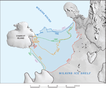
FIGURE USGS scientists studying coastal and glacier change along the Antarctic coastline have documented significant ice-sheet retreat in part of the southern Antarctic Peninsula between 1947 and 2009. Maps such as this one are presented in the USGS report Coastal-Change and Glaciological Map of the Palmer Land Area, Antarctica: 1947—2009 (map I—2600—C). SOURCE: USGS (gallery.usgs.gov/photos/02_18_2010_hLc5FSq11Y_02_18_2010_0).
the U.S. Department of Agriculture, the National Aeronautics and Space Administration (NASA), and the National Oceanic and Atmospheric Agency (NOAA).
In another example, management of Landsat enables the Survey to play an important role in developing international protocols and conventions for coordinating Earth observations (e.g., through the Committee on Earth Observation Satellites). Furthermore, Landsat activity integrates across nearly all USGS science strategy areas, and strongly supports national-interest activities such as disaster response, biodiversity monitoring, and hydrologi-cal analyses on a worldwide basis (see also next section on Core Science Systems).
Individually and collectively, USGS scientists bring expertise and approaches to work in climate and land-use change that strengthen the national climate science enterprise and contribute to the global advancement of climate and land-use science.
Mission Area and Core Activities
The USGS conducts surveys in geology, hydrology, geography, and biology to support work of user communities in USGS mission areas. Such work has a strong spatial component and requires a comprehensive mapping capability and infrastructure that is in the purview of the Core Science Systems function, which is carried out through the Biological Informatics Program, National Geospatial Program, National Cooperative Geologic Mapping Program, National Geological and Geophysical Data Preservation Program, USGS Libraries, and Core Science Informatics (see Box 3.3).
Current International Activities
In the USGS Biological Informatics Program, the Integrated Taxonomic Information System (ITIS) is building a database of species names and their hierarchical classification, for which coordination with both national and international biodiversity programs is essential. Similarly, the National Biological Information Infrastructure (NBII) Geospatial Interoperability Framework (GIF) strategy is based on International Standards Organization (ISO) standards and Open Geospatial Consortium (OGC) specifications (see next paragraph), to ensure reciprocal mobility of data at the international level. Other major USGS international initiatives are the World Data Center for Biodiversity and Ecology, the Global Biodiversity Information Facility (GBIF), and the Inter-American Biodiversity Information Network (IABIN).
Within the National Geospatial Program, the Global Earth Observation System of Systems (GEOSS) and the Group on Earth Observations (GEO) are important international coordination mechanisms. In addition, through the Federal Geographic Data Committee (FGDC), the USGS is engaged in the OGC, an international consortium of over 400 companies, government agencies, and universities that participate in a consensus process to develop publicly available interface standards designed to spatially enable Web, wireless services, and location-based services. These standards enable technology developers to make complex spatial information and services accessible and useful with a broad range of applications.
As previously mentioned, Landsat is another example of a comprehensive global program coordinated by the USGS. Landsat represents the world’s longest continuously acquired collection of space-based moderate-resolution land remote sensing data. It provides a valuable resource for users worldwide who work in agriculture, geology, forestry, regional planning, education, mapping, and global change research.4
__________________
4 Landsat satellites were initially designed, built, launched and operated by NASA throughout the 1970s; operational control and management of the satellites was transferred to NOAA in 1981. USGS assumed operational management of Landsat in 1999. Further information on the history of Landsat is available in NRC (2011b).
BOX 3.3
Programs in Core Science Systems at the USGS
Biological Informatics Program examines issues at the intersection of biological and information science. The program works with partners to maintain the informatics framework needed for the understanding and management of U.S. biological resources. Major program components include state, regional, and national conservation assessments of native vertebrate species and natural land-cover types; taxonomic, biological, and vegetation information and characterization; and the USGS Science Center Informatics Programs.
National Geospatial Program makes and maintains topographic mapping to produce The National Map. The program works cooperatively to share the costs of acquiring and maintaining geospatial data. It also encompasses the Federal Geographic Data Committee, which promotes consistent data and metadata standards, system interoperability, and cross-government best business practices for geospatial resources, policies, standards, and technology as part of the National Spatial Data Infrastructure.
National Cooperative Geologic Mapping Program produces geologic mapping to enhance understanding of earth materials, processes, and history across areas including energy, mineral, and water resources, and natural hazards. The program coordinates and supports the production of most geologic maps in the United States through cost-shared federal-state-university partnerships.
National Geological and Geophysical Data Preservation Program is responsible for archiving geologic, geophysical, geochemical, and engineering data, maps, well logs, and samples. The program provides and maintains a national catalogue of archived materials and provides technical and financial assistance to state geological surveys.
USGS Libraries support comprehensive access to USGS literature, data, and information and serve both internal and external users. There are four branch libraries and there is support for 22 Center Libraries. The collection features 1.5 million volumes of data spanning over 400 years, and 500,000 maps over the globe. The Digital Library Plan encompasses digitization of all USGS-published literature within 5 years, migration of services online, and curation of digital content for long-term accessibility.
Core Science Informatics coordinates and develops data integration services, capacity, and framework for Bureau science programs. It supports identification and development of best practices and standards to ensure efficiencies and innovation. It also works with USGS science programs, partners, and industry to improve methods for accessing, integrating, visualizing, and delivering USGS information.
The National Cooperative Geologic Mapping Program (NCGMP) provides accurate geologic maps and three-dimensional framework models that support efforts to mitigate natural hazards. The Program works to integrate geologic mapping with progress in geologic research worldwide, including using classifications, symbols, and terminology compatible with usage throughout the international business and research communities, and ensuring that maps are usable by a broad range of clients. For decades, these requirements have been achieved through close coordination with the International Commission on Stratigraphy (ICS), the International Geological Correlation Programme (IGCP), and the Commission for the Geological Map of the World (CGMW). In recent years, OneGeology,
an international initiative of the world’s geological surveys dedicated to making geologic map data for the Earth widely accessible, has been of escalating importance.
VALUE TO USGS DOMESTIC MISSION
Core Science Systems addresses mapping, monitoring, and regional geology directly in support of all other science activities at the USGS. Well described as “ground truth,” geologic maps constitute the worldwide test of the theories, measurements, and analyses of all other mission areas of the USGS. Geologic maps are indispensable for understanding the deep Earth, energy and mineral resources, Earth surface processes, and groundwater availability and quality. Such cartographic data inform and support DOI land management decisions, hazard mitigation, resource identification and evaluation, ecological and climatic monitoring and modeling, and understanding of onshore-offshore sediment processes.
RELEVANCE TO U.S. NATIONAL INTERESTS
Mapping and related monitoring activities help to sustain and improve the quality of life and economic vitality of the nation by providing the basis for decisions about natural hazard mitigation, land-use planning and management, natural resource development and conservation, and ecosystem and environmental issues. In addition, oversight of global, space-based, moderate-resolution land remote sensing data, Landsat, and other geographically referenced datasets enables users in federal, state, and local governments to conduct tailored research with layered, georeferenced data in many different areas of the United States and the world. This access facilitates project reconnaissance, planning, and data collection on the ground; research in areas that are otherwise difficult or impractical to access for ground-based field studies; and continuous monitoring of regions with the potential to collate different kinds of data for the same location to understand changes in Earth processes over time.
Mission Area and Core Activities
USGS expertise allows the Survey to advance the understanding of U.S. terrestrial, freshwater, coastal, and marine ecosystems and predict ecosystem change. The USGS mission on Ecosystems involves activities such as reporting on the state of the nation’s ecosystems; studying the causes and impacts of ecological change; and monitoring and providing methods for the protection and management of biological components and processes of ecosystems. Issues such as the distribution, condition, and conservation of organisms and
predictions of biodiversity change—in conjunction with climate and land-cover change— also fall under the purview of this science direction (DOI, 2011).
Core activities focus on ecological and environmental change in the nation’s ecosystems and on the implications for resource managers and the public. The USGS organizes its ecosystem science work into major programs on Invasive Species, Fisheries Resources, Terrestrial Resources, and Terrestrial Freshwater and Marine Environments. Although many of the programs and activities in this science area are conducted at USGS science centers and field stations, understanding the full range of stresses and vulnerabilities and the potential ecosystem responses is enhanced by investigations conducted outside U.S. borders. Such studies yield information about how similar systems respond to change (e.g., Figure 3.1) and provide understanding of corresponding international perspectives on resources and management strategies. Many USGS scientists and collaborators have developed considerable expertise and experience in this area as a result of their international research and collaborations.
Current International Activities
USGS international work provides key information on global drivers of ecosystems in U.S. territory. Ecosystem and biological science activities with international components
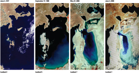
FIGURE 3.1 “The Vanishing Aral Sea.” Located in Kazakhstan and Uzbekistan, the Aral Sea was previously one of the largest inland bodies of water. USGS Landsat images capture its diminishing capacity over the span of 30 years due to water usage upstream for crop irrigation. The shrinkage has changed the ecological balance of the area and contributed to habitat loss, increased numbers of sandstorms, and noticeable changes in climate conditions for the region. SOURCE: USGS (landsat.usgs.gov/about_LU_Vol_3_Issue_4.php).
conducted by the USGS range from wildlife disease research to invasive species studies and conservation programs. For instance, to better understand the threats of invasive species into the United States, the USGS Invasive Species Program strategically seeks to “initiate/expand research efforts and cooperation with source countries for introduction of new invasive species into the United States (e.g., China, Russia, and Ponto-Caspian region of Russia, South Africa, Australia/New Zealand, Canada/Mexico)” (USGS, 2004). Further examples of USGS activities involving an international approach are described in Box 3.4.
VALUE TO USGS DOMESTIC MISSION
USGS ecosystems activities support the larger DOI mission to “provide a scientific foundation for decision making” by identifying and predicting ecosystem change and by
BOX 3.4
Examples of USGS Ecosystem Activities with International Dimensions
Global Wildlife Disease News Map. Carried out under the auspices of the National Wildlife Health Center through the National Biological Information Infrastructure program, the Global Wildlife Disease News Map presents a visual display of data illustrating the locations of reported wildlife disease outbreaks worldwide. It is the only global surveillance system for monitoring wildlife diseases in the world. Users can see wildlife disease headlines, both locally and globally, and study how such diseases (e.g., West Nile virus) can impact livestock and human health (see Figure).
National Invasive Species Management Plan. USGS scientists play a leading role in implementing a plan to provide a scientific basis for preventing, detecting, and managing invasive species, which can pose a serious threat to U.S. interests. For example, USGS scientists are studying how to better manage the population of nonnative Asian carp, whose population numbers have been increasing exponentially and posing a threat to native fish populations.
North American Breeding Bird Survey. The North American Bird Breeding Survey (BBS) generates data critical for conservation and regulatory purposes (e.g., setting hunting limits for game birds and waterfowl). It is a cooperative effort between the USGS and the Canadian Wildlife Service, and USGS scientists use BBS data to provide information management for the bird banding program.
Partners in Flight. The USGS partners with other federal agencies and with state, local, nongovernmental, and private groups to advance science-based conservation and management of bird species throughout the Americas. Initially focused on neotropical migrants, the program has expanded its goals to include conservation of all birds that require terrestrial habitats.
Great Lakes Fisheries. USGS scientists study this high-priority ecosystem for domestic purposes (especially the high-value fisheries in the lakes) where international considerations are essential. The Great
providing an understanding of connections between the natural environment and wildlife and human health (DOI, 2008). Most USGS capabilities in ecosystem science originated in the transfer of research staff and responsibilities from other DOI agencies in the creation and then reorganization of the U.S. Biological Survey, and thus there are intrinsic linkages and partnerships between USGS and federal resource management agencies (e.g., Fish and Wildlife Service, National Park Service).
Transboundary examples of USGS work include major research efforts in the Great Lakes region, where the Upper Midwest Environmental Sciences Center partners with several Canadian governmental agencies on fisheries and on river science, restoration, and management efforts. In addition, USGS capabilities in monitoring and spatial technologies have made the agency a core participant in North American collaborations to understand migratory birds, especially waterfowl. For example, USGS scientists have worked with
Lakes Science Center is the only organization in the United States and Canada that has a research vessel with deepwater capability on each of the Great Lakes, enabling comparative offshore field studies on fish population dynamics and related habitat research topics.
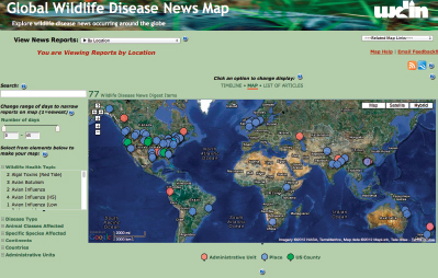
FIGURE Screenshot of the USGS Global Wildlife Disease News map. SOURCE: USGS (wildlifedisease. nbii.gov/wdinNewsDigestMap.jsp).
Canadian and South American colleagues to develop technologies for tracking migratory birds (e.g., Farmer et al., 2004).
As globalization affects the speed and distance with which disease and invasive species cross the planet, vital U.S. resources may be vulnerable. The USGS has unique capabilities in geospatial technologies and information management that are key elements in efforts to track and project emerging threats to biological resources from outside the nation’s boundaries. The USGS National Wildlife Health Center is the primary source of support for the Wildlife Data Integration Network and the Global Wildlife Disease News Map, which shows the emergence and movement of disease outbreaks in wildlife species outside the United States. USGS mapping and data-sharing capacity are essential for forecasting diseases that could affect U.S. wildlife resources and for real-time tracking of wildlife pathogens that may be zoonotic (e.g., avian influenza, West Nile virus) and affect human health. For example, international collaboration has allowed geneticists at the Western Fisheries Research Center to lead efforts to describe and better understand serious threats to commercial fisheries in the Great Lakes posed by viral hemorrhagic septicemia virus (USGS, 2010b).
Similarly, species that cross international borders during natural or human-influenced migration can affect local human populations, indigenous plant and animal species, and ecosystems. USGS has built on its expertise in detection, monitoring, and mapping to develop major programs aimed at understanding and mitigating the threats of invasive species. Unique data-sharing capabilities, such as the Global Invasive Species Information Network and the Pacific Basin node, were established through the NBII to track and share information on highly invasive species and their associated threats among U.S. territories and other Pacific island nations. These core capacities in mapping and monitoring have built a foundation for forecasting the arrival and spread of invasive species from outside the nation’s boundaries. For example, the USGS Southeast Ecological Science Center has been involved in mapping and understanding the impacts of the exotic lionfish (Pterois spp., see Figure 3.2) through the Caribbean, whose explosive spread is severely impacting native fish populations and coral reefs (USGS, 2011b).
International work related to the nation’s ecosystems is necessary to improve understanding of certain threats by studying them in their place of origin. While the scientific literature and other data-sharing approaches provide adequate background to assess threats, such information is not always available. For example, many plant species that have proven to be invasive in North America are not weedy or aggressive constituents in their home ranges and thus have not attracted much attention from researchers there. New work is thus essential to identify natural enemies for biocontrol.
RELEVANCE TO U.S. NATIONAL INTERESTS
Ecosystem function and health are increasingly being understood as having national security implications. The DOS has identified soil conservation, sustainable development

FIGURE 3.2 Adult lionfish (Pterois spp.). The lionfish is an invasive species whose population has rapidly spread throughout the Atlantic Ocean, Caribbean, and the Gulf of Mexico. SOURCE: USGS, photo by James Morris, Jr.
-
of watersheds, and other environmental issues as critical to short- to medium-term security and foreign relations (Reynolds, 2011). Accordingly, the USGS has been involved in relevant ecosystem projects such as
- Southwest Border monitoring. The USGS partners with the Department of Homeland Security (DHS) to quantify the impacts of fencing, barriers, lighting, and other border security infrastructure on natural and cultural resources along a 700-mile-long section of the U.S.-Mexico border.
- Information management support. From genomics and biological diversity to geospatial and remote system data, USGS has been a leader in developing advanced information management capabilities that facilitate data sharing, international collaboration, and effective problem-solving. Among its contributions are the Global Biological Information Facility, Global Invasive Species Information Network, NBII, and International Taxonomic Information System (see also Core Science Systems section, above).
- Delta Research and Global Observation Network (DRAGON). The USGS studies major coastal delta systems similar to the Mississippi River Delta by drawing
-
on scientific studies of massive river systems in Asia, Africa, Europe, and South America (Figure 3.3). DOS’s lower Mekong River activities are built on DRAGON collaborations, which in turn draw on the expertise of the USGS National Wetlands Research Center (Farris, 2010). The modeling and management tools being developed as a result of this work can strengthen domestic capabilities in the Mississippi Basin, and the associated international collaborations have considerable value for foreign relations (Reynolds, 2011).
- Arctic sea ice ecosystem and species conservation work. Modeling sea ice and the relationship of key species populations (e.g., polar bears and walruses) for conservation
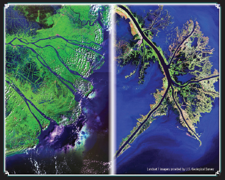
FIGURE 3.3 Research on major river delta systems around the globe have allowed USGS scientists to improve understanding of the U.S. Mississippi Delta (right) and the Mekong Delta (left) in southeast Asia. The USGS Delta Research and Global Observation Network (DRAGON) partnership, operating through the U.S. government’s Lower Mekong Initiative, draws on USGS expertise to assist countries in the Mekong Delta area in assessing the actual and potential impacts of human activities and climate change on the ecology and food security of the Mekong River basin. SOURCE: USGS (deltas.usgs.gov/).
-
and management in the Arctic region has been a high-priority USGS effort for several years. Changing sea ice patterns and ecosystem function in the Arctic have major implications for access to both biological (fisheries) and abiotic (mineral, oil, and gas) resources in the region (see section on Climate and Land-Use Change). For instance, access to new resources is tied to ongoing diplomatic and commercial negotiations among the Arctic nations, including Russia, Canada, and several northern European countries. USGS wildlife and ecosystem scientists have been key participants in multinational studies of marine mammal and fisheries resources in the Arctic, and USGS scientists are collaborating to provide research and monitoring for multinational polar bear management efforts (e.g., Stirling et al., 2011).
- Environmental status of boundary rivers. The USGS Columbia Environmental Research Center conducts a program on Biomonitoring of Environmental Status and Trends in the Large Rivers Monitoring Network. USGS scientists collect data on biological and contaminant condition of resources in the Colorado, Rio Grande, and Yukon river basins that are important to U.S. relationships with Canada and Mexico.
Mission Area and Core Activities
The USGS conducts strategic research to identify and understand the occurrence, size and extent, and genesis of energy and mineral resources. Data and information acquired with this research inform national decisions about domestic land management and use, management of energy supplies and mineral resources, international trade, national security, and environmental quality. The USGS identified four strategic areas to focus its efforts in energy and minerals for the 2007-2017 period: (1) natural resource security for the future,5 (2) environmental health, 6 (3) economic vitality of the nation, and (4) management of DOI and other lands. The core activities within energy and mineral resources are described separately below (Brady and Doebrich, 2011).
CORE DOMESTIC ENERGY RESOURCE ACTIVITIES
The main activities in energy resource research at the USGS include oil and gas; coal; other energy (such as gas hydrates, geothermal energy, wind energy, uranium, and oil shale);
__________________
5 See www.usgs.gov/start_with_science/docs/energy_minerals.ppt (accessed July 11, 2011).
6 See www.usgs.gov/resources_envirohealth (accessed July 11, 2011).
and geologic carbon sequestration (Box 3.5). Core activities related to oil and gas include (1) national assessments of undiscovered oil and gas resources in areas such as the Gulf Coast and Cook Inlet, Alaska; (2) identification of unconventional oil and gas projects;
BOX 3.5
Geologic Carbon Sequestration
The Energy Resources Program has been a primary contributor to the USGS Carbon Sequestration Program by developing a method to estimate the CO2 storage potential of different geologic formations in the United States (Brennan et al., 2010). This method is used by the USGS to assess storage resources on a large scale (the scale of geologic basins). The USGS is also conducting research to refine current and future CO2 storage potential. Some of this work has been undertaken in response to the Energy Independence and Security Act of 2007.a The Carbon Sequestration Program spans multiple mission areas at the Survey (see Figure), including Climate and Land-Use Change, where the program is administered, and Environmental Health, which contributes research about the potential environmental impacts of carbon sequestration.
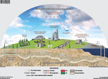
FIGURE Illustration depicting the concept of geologic carbon sequestration. SOURCE: USGS; Duncan and Morrissey (2011).
________________________
aPublic Law 110-140 (available at www.gpo.gov/fdsys/pkg/PLAW-110publ140/content-detail.html
(3) monitoring of reserve field growth—or the potential for oil and gas fields to increase total proved reserves over time; and (4) research in energy economics.
Coal research entails resource assessments, analysis of coal quality, research on coalbed natural gas, and studies of the impact of coal on human health. Gas hydrate and geothermal research are two examples of work within “other” energy sources at the USGS. These activities include cross-agency, interdisciplinary research and development projects for gas hydrates on the Alaska North Slope and offshore Gulf of Mexico (NRC, 2010) and projects to support exploration for geothermal resources and potential energy development, especially in the western United States.7 The USGS collaborates extensively with other DOI bureaus as well as with the Department of Energy (DOE), National Science Foundation, Environmental Protection Agency (EPA), and Department of Defence (DOD) on these topics.
CORE DOMESTIC MINERAL RESOURCE ACTIVITIES
The Mineral Resources Program supports research for two primary functions: (1) research and assessment and (2) data collection, analysis, and dissemination (USGS, 2011c). Quantitative assessments are conducted to determine the potential for undiscovered mineral deposits. Such work involves updating national mineral resource assessments, assessing techniques for evaluating concealed mineral deposits, developing an understanding of mineral systems, developing data and information for minerals on federal lands, evaluating risk and uncertainty in mineral resource assessments, investigating minerals and materials used by industry, and conducting mineral life cycle analysis (including materials flow and supply chain studies). These studies also include data collection, modelling, and development of methods to determine the potential environmental impacts on federal lands of mineral exploration and production. The collection, analysis, and dissemination of mineral commodity information (see discussion of international activities in next section) have been the subject of enormous interest in the last decade, and particularly in the last several years as interest in important minerals such as the rare earths has increased dramatically (e.g., NRC, 2008).
CURRENT INTERNATIONAL ACTIVITIES—ENERGY AND MINERALS
The USGS World Petroleum Assessment 2000 is an impartial, science-based resource on global petroleum information and data. The USGS is updating these assessments and has also begun to conduct newer, more detailed assessments for the Circum-Arctic, basins in Ukraine, Russia, and Belarus, coastal West Africa and north-central Africa, and South America (Figure 3.4).8
__________________
7 See also energy.usgs.gov/Coal.aspx; energy.usgs.gov/OtherEnergy/Geothermal.aspx.
8 See energy.usgs.gov/OilGas/AssessmentsData/WorldPetroleumAssessment.aspx.
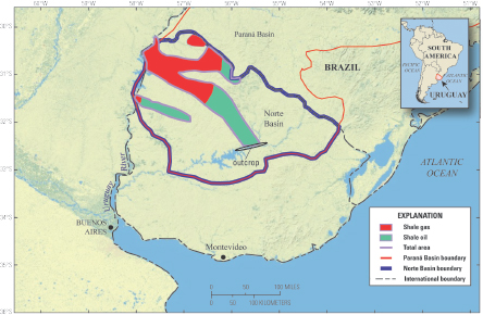
FIGURE 3.4 The Norte Basin in Uruguay and the areas of the Devonian Cordobés Formation Shale Gas Assessment Unit (red) and Devonian Cordobés Formation Shale Oil Assessment Unit (green). SOURCE: Schenk et al. (2011).
Estimates of high concentrations of gas hydrates on the world’s continental shelves have encouraged international interest in gas hydrate as a potential energy source. The USGS has been engaged in gas hydrate research for several decades and been a key collaborating partner in such research with Japan, South Korea, India, Canada, and several other countries, generally working together with the Department of Energy (e.g., NRC, 2010). In the area of geothermal energy, USGS scientists have engaged in planning experiments at geothermal fields in Soultz-sous-Forêt (France), Iceland, and Tyrniauz (Russia), and have participated in several projects in Japan.
The quantitative Global Mineral Resource Assessment Project addresses the needs of the federal government, industry, and research community for global minerals information to aid in decision making. Regional reports provide assessment of nonfuel mineral deposits in Latin America, Canada, Asia and the Pacific, Europe and northern Central Asia, and Africa and the Middle East (e.g., Schulz and Briskey, 2005). Analyses are also available for specific types of resources, such as minerals containing rare earth elements (e.g., Long et al., 2010; USGS, 2011c) and porphyry copper in South America (Cunningham et al., 2008) and Mexico (Hammarstrom et al., 2010).
The annual Mineral Commodity Summaries (USGS, 2011c) and Minerals Yearbook9 compiles information on the worldwide supply, demand, and flow of minerals and materials, with analysis of mineral production, consumption, and resource information for 180 countries. The USGS also provides mineral life cycle analysis (including global materials flow and supply chain) of different minerals. One such study was requested by the Organization for Economic Cooperation and Development on global flow of aluminium, and another was recently released on the effects of the March 2011 earthquake and tsunami on mines and mineral processing in Japan (Menzie et al., 2010, 2011).
An example of a cross-cutting international research activity among Mineral Resources, the Toxic Substances Hydrology Program (in the Environmental Health science area), and the Water science area (see subsequent sections) is the examination of mercury sources and global mercury cycling. This activity is described in detail in the next section on Environmental Health.
VALUE TO USGS DOMESTIC MISSION
An important function of the USGS Energy and Mineral Resources mission area is the quantification of current energy and mineral resources production, consumption, imports and exports. USGS expertise and information on these topics directly support numerous energy and mineral resource activities across the federal government, and the Survey often collaborates with other DOI agencies (e.g., Bureau of Land Management, Bureau of Ocean Energy Management, Fish and Wildlife Service, Bureau of Indian Affairs) and with the DOE, DOD, DOC, EPA, and U.S. Forest Service. Each of these collaborating agencies has specific responsibilities and roles in terms of regulation, permitting, leasing, land management, oversight, and environmental protection. In partnership with these other federal agencies and the private sector, the USGS fulfils a key domestic mission as a purveyor of reliable and unbiased energy and mineral data and information to the federal enterprise, industry, and the American public.
RELEVANCE TO U.S. NATIONAL INTERESTS
The ongoing and recently completed projects and activities in this mission area have complementary domestic and international benefits, as is evident from the strong U.S. and foreign interest in the global distribution of energy and mineral resources. Imports of these resources have the potential to affect U.S. economic development and national security, thus information on global and domestic resource distribution and availability can inform decisions about risks associated with import dependence and possible actions to mitigate supply risk. Understanding the life cycle of energy and mineral resources and of practices
__________________
9 See also minerals.usgs.gov/minerals/pubs/myb.html.
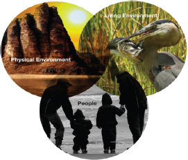
FIGURE 3.5 The interrelationship of the quality of the physical environment, the health of the living environment, and human health as it relates to environmental health science. SOURCE: USGS (www.usgs.gov/start_with_science/docs/enviro_overview.pdf).
to make resource use more efficient and less harmful of the environment is also important for the country.
From a geopolitical perspective, the USGS also plays a key role in assessing the availability and potential role of energy and minerals in other countries, as part of the effort to support investment, development, and political stability in these countries while potentially increasing supply to the world market (see Section 3.8 for a detailed description of an Afghanistan project). Some international energy and mineral projects include collaboration with developed nations to enhance the scientific exchange of ideas and information, develop national and global databases, and bolster the quality of scientific energy and mineral resource development in the participating countries (including the United States).
Mission Area and Core Activities
The USGS defines environment health as “The multi-disciplinary study of relationships among the quality of the physical environment, the health of the living environment, and human health” (Figure 3.5).10 The link between environmental health and human
__________________
10 See www.usgs.gov/start_with_science/docs/enviro_overview.pdf.
BOX 3.6
Environmental Impacts on Human Health
Human health is determined by intrinsic characteristics and influenced by external exposures through air, water, food, or contact. It is also dependent on the health of the surrounding environment and wildlife. Environmental contaminants and increasing evidence of zoonotic and vector-borne diseases are of concern around the world. Current scientific information is important to understand and address chemical and pathogenic contaminants in water, air, dust, and soil, and in food that may threaten public health. According to the Institute of Medicine’s Roundtable on Environmental Health Sciences, Research, and Medicine, “In its broadest sense, the environment is one of the major determinants of human health and well-being … Underlying the need for enhanced education of health professionals is the need for more research… that will further elucidate the linkages that exist between the environment and human health” (IOM, 2004).
Many adverse exposures stem from anthropogenic disturbances of the natural environment, others from natural sources near or at the Earth’s surface. Research on Earth sciences–including geology, geophysics, geochemistry, geomorphology, soil science, mineralogy, hydrology, mapping, remote sensing, and other subdisciplines–yields critical information about natural Earth materials and processes to enhance understanding of such adverse exposures.
________________________
SOURCE: IOM, 2004; NRC, 2007; USGS, 2008.
health is well established, but the relationship between environmental health and Earth processes has not been examined as extensively, although such information is necessary for protecting public and environmental health and supporting U.S. national interests. The impact of Earth minerals and processes on human health was recognized in the 2007 National Research Council report Earth Minerals and Health: Research Priorities for Earth Science and Public Health (NRC, 2007). A recent USGS report also acknowledged the nexus between environmental health and human health (USGS, 2008; see Box 3.6).
The USGS has undertaken a systems approach to examine the impacts of Earth processes on environmental health, with the following goals outlined for activities in this area:11
- Anticipate, detect, and assess emerging threats from contaminants and diseases that affect aquatic and terrestrial organisms and humans.
- Characterize both the environmental factors that control exposure to natural and anthropogenic contaminants and their effects on aquatic and terrestrial organisms and humans.
- Elucidate the ecological and environmental factors that influence the occurrence
__________________
11 See www.usgs.gov/start_with_science/docs/enviro_overview.pdf.
-
and evolution of infectious diseases that affect aquatic and terrestrial organisms and humans.
- Determine interactions among contaminants, pathogens, environmental changes, and other stressors that together affect the health of aquatic and terrestrial organisms and humans.
- Enhance methods to anticipate and rapidly assess the environmental impacts of natural or anthropogenic disasters on the health of aquatic and terrestrial organisms and humans.
- Synthesize and communicate integrated environmental health science information to decision makers and the public.
Determining routes of exposure through which human health can be adversely impacted might be a helpful way to identify work in other USGS mission areas that has direct links to environmental and human health (see Table 3.1). Quantitative microbial risk assessments require exposure and dose response data to characterize risk, yet such data may not be readily available for risks that are not prevalent in the United States. By studying cases outside the United States, USGS scientists can glean valuable information to examine linkages between environmental contaminants and human health. For example, in Bangladesh, historical contamination of surface waters with waterborne pathogens necessitated the drilling of tube wells to reach pristine groundwater, which inadvertently resulted in the largest mass poisoning of arsenic-contaminated water ever recorded. The USGS has since been involved in decade-long studies in Bangladesh to develop new analytical methods for arsenic detection and for understanding processes that affect arsenic mobilization. All of these efforts are directly applicable to arsenic issues in the United States and illustrate how the route of exposure (in this case, consumption of potable water) can result in devastating adverse human health effects.
Current International Activities
USGS domestic and international activities related to environmental health address public health impacts of arsenic groundwater contamination, wildlife diseases (particularly zoonotic diseases, which are transmissible between animals and humans), natural hazards, and water, air, and soil quality (see Box 3.7). For example, the Global Wildlife Disease News map (see Box 3.4) provides an invaluable service by tracking the emergence of diseases such as avian influenza in migratory birds and West Nile virus in wild birds, and serves as an “early warning system” for emerging wildlife pathogens. The USGS National Wildlife Health Center is also involved in disease surveillance of birds, sea turtles, fish, amphibians, and coral reefs, and in detecting invasive pathogens and emerging diseases in wildlife (USGS, 2011d). These and many other Environmental Health activities involve expertise from several USGS mission areas.
TABLE 3.1 Routes of Exposure That Result in Adverse Human Health Effects: Links to Research in Other USGS Mission Areas
| Exposure Route | Explanation of Risk |
Example of Specific Activity |
USGS Mission Areo(s) |
Adverse Health Effect |
| Inhalation | The human respiratory system consists or organisms and tissues in the upper body which allow us to breathe ambient air, extract oxygen, and respire carbon dioxide back into the atmosphere. Inhalation of hazardous materials in ambient air can cause adverse health effects and disease. Such hazardous materials can be found in gas, liquid, or solid matter. | Volcanic eruption in Laki Iceland | Natural Hazards | Death From volcanic gas inhalation (SO2), HCI and HFJ (Stone, 2004) |
| Ingestion: water | Water is essential to life and good health, but unfortunately safe, healthy potable water is in limited global supplies. In addition, interactions between potable water and anthropogenic or natural contaminants can compromise potable water quality. | Tube well drilling in Bangladesh | (1) Water (2) Energy and Minerals | Mass poisoning via arsenic (Chowdhury et al., 2000) |
| Ingestion: Food | Food is essential to life and good health, and it is alio susceptible to contamination by anthropogenic or natura contaminant. | Mine and smelting in Toyama Province, Japan | Energy and Minerals | Cadmium contamination of rice (Alloway, 2005) |
| Infection | A variety of viral, bacterial, and protozoan pathogens can infect humans and cause disease. In addition, helminth infections from organisms such as A$cari$ infect billions of people worldwide (Fleming et al., 2006). Exposure to such pathogens can be due to multiple and diverse factors. | Global worming induced El Nino events in South America | Climate and Land-Use Change | Enhanced incidence of cholera (Gil etal, 2004) |
| Reforestation in northeastern United Stales | Ecosystems | Enhanced incidence of Lyme Disease (NRC, 2007) | ||
BOX 3.7
Examples of USGS Projects in Environmental Health
Arsenic groundwater contamination. USGS involvement in studies of groundwater contamination in Bangladesh has yielded information that is directly applicable for arsenic groundwater contamination issues in the United States. Specifically, results from examining the microbiological, biochemical, and hydrogeologic processes that control the mobilization of arsenic from geologic materials critically enhance understanding and thus support efforts to mitigate the impacts of such contamination. Over the past decade, USGS has participated in multiple international evaluations of arsenic contamination and used new methods of analyses (Breit et al., 2006, 2007).
Avian influenza. The USGS has been active in efforts to sample and test high-priority migratory bird species for highly pathogenic avian influenza. The National Wildlife Health Center performs laboratory testing of birds known to migrate between Asia and North America and investigates wild bird mortality events throughout the United States (USGS, 2007c).
Natural hazards. The USGS has been critically involved in international activities and partnerships that use predictive monitoring for disaster prevention and mitigation, as well in providing assistance after earthquakes, tsunamis, or volcanic eruptions. Such participation benefits national USGS studies in support of efforts to reduce the impacts of natural hazards on public health (Ewert et al., 2005).
Water, air, and soil quality. The USGS engages in interdisciplinary research on the relationship between human health and environmental quality on both sides of the U.S.-Mexico border, evaluating water, air, and soil quality (including the effects of heavy metals and pesticides) (Papoulias et al., 2006).
VALUE TO USGS DOMESTIC MISSION
USGS information on the effects of water, air, and soil contaminants on environmental health supports work and collaboration with other DOI agencies (e.g., Fish and Wildlife Service, Bureau of Reclamation, Bureau of Land Management, Bureau of Indian Affairs), as well as other federal agencies such as the Environmental Protection Agency, Department of Homeland Security (DHS), DOD, and the Centers for Disease Control and Prevention (CDC). For example, research on natural hazards and their effects on human health is relevant to emergency managers and incident specialists in the Federal Emergency Management Agency (FEMA) and DOD, as is work related to climate and land-use change for the CDC (e.g., climate change influencing the incidence of thermo-tolerant organisms such as Legionella pneumophila and Naegleria fowleri). Research studies related to energy and minerals in the area of bioremediation are of interest to the National Institute of Environmental Health Sciences. International data collection in the areas of exposure and dose response can be extremely beneficial to domestic risk characterization and assessments.
RELEVANCE TO U.S. NATIONAL INTERESTS
Environmental health can impact public health; therefore, several USGS international activities in this area are of national interest, as illustrated by the following examples:
- A USGS scientist joined a team at the Pasteur Institute in Tunis, Tunisia, to study the transmission and prevention of zoonotic cutaneous leishmaniasis, a pathogen commonly found in parts of Africa that is transmitted by sand fly and carried by rodents.
- USGS wildlife experts use satellite telemetry in support of avian influenza surveillance programs, tracking the waterfowl movement across Hong Kong and India in order to understand migratory pathways and interactions between wild and domestic birds.
- A USGS scientist who studied the source of mercury in the ocean helped demonstrate that mercury from the atmosphere settles in the ocean and can end up in fish that are harvested for human consumption (Krabbenhoft, 2009). Health managers use this knowledge to minimize human exposure to mercury through marine fish consumption.
- USGS researchers explore links between coal aquifers and the kidney disease Balkan Endemic Nephropathy (BEN), which is suspected of decreasing viability and inducing cell death in human kidney cell lines. The research helps U.S. scientists to understand links between kidney disease and coal aquifers that supply drinking water in the United States.
Escalating losses from natural disasters have become a societal problem worldwide—all too evident from the recent impacts of major earthquakes, tsunamis, floods, volcanic eruptions, hurricanes, and landslides. A chronicle of such major disasters12 indicates their alarming frequency. To address these events, the USGS Natural Hazards mission area encompasses six program elements: Earthquake Hazards, Volcano Hazards, Landslide Hazards, Global Seismographic Network, Geomagnetism, and Coastal and Marine Geology (USGS, 2007d).
Mission Area and Core Activities
The strategic science direction for the USGS Natural Hazards mission area (USGS, 2007b) calls for continuous collection of accurate and timely information from Earth
__________________
12 International Charter: Space and Major Disasters (see www.disasterscharter.org/web/charter/activations).
observation networks, natural hazards risk assessments, and research to improve hazard predictions. This mission area also coordinates and supports the broader work of the USGS— including floods, hurricanes and severe storms, tsunamis,13 and wildfires—and it coordinates USGS response activities following disasters (Eichelberger, 2011). These activities fall under Goal 4, Increase the Resilience of Communities to Geologic and Environmental Hazards, articulated in USGS Circular 1369 on Implementing the USGS Science Strategy, which “emphasizes the need for providing real-time, integrated national monitoring and warning systems, conducting research to better understand risk, and planning effective communications products and partnerships to build resilient communities across the globe” (Gundersen et al., 2011, p. 2). Key information sources for the activities of the six program elements described below include the DOI (USGS, 2011a), Eichelberger (2011), and the USGS Natural Hazards website.14
EARTHQUAKES AND VOLCANOES
The USGS has the lead federal responsibility to monitor and provide notification of earthquakes in the United States and worldwide, and the USGS Earthquake Hazards Program is a central part of the National Earthquake Hazards Reduction Program (see NEHRP, 2011), a joint effort of the USGS with the National Science Foundation (NSF), DHS (FEMA), and the National Institute of Standards and Technology. Seismic monitoring for the nation is achieved through the Advanced National Seismic System (ANSS), a real-time earthquake information system operated by the USGS together with state and university partners. As an integral part of ANSS, the USGS operates the National Earthquake Information Center (NEIC), located in Golden, Colorado, and staffed on a 24/7 basis to provide rapid and accurate information on earthquakes worldwide.
Critical data for continuous worldwide earthquake monitoring and rapid reporting by the USGS come from the Global Seismographic Network (GSN), a permanent digital network of more than 150 globally distributed seismic stations, operated as part of a joint USGS-NSF program. GSN stations provide near-real-time data to tsunami warning centers operated by NOAA, and 97 percent of GSN stations transmit real-time data continuously to the NEIC (DOI, 2011).
The Volcano Hazards Program (VHP) monitors active and potentially active volcanoes, assesses their hazards, responds to volcanic crises, and conducts research on volcanic phenomena. In 2005, the VHP completed a systematic assessment of volcanic threat and
__________________
13 The National Tsunami Hazard Mitigation Program of 1995 designates the National Oceanic and Atmospheric Administration (NOAA) as the lead federal agency for addressing tsunami hazards affecting the U.S.—in partnership with the USGS, the Federal Emergency Management Agency (FEMA), the National Science Foundation (NSF), and the 28 U.S. Coastal States, Territories, and Commonwealths.
monitoring capabilities for all 169 of the nation’s active volcanoes and developed a framework for a National Volcano Early Warning System (NVEWS), with state-of-the-art volcano monitoring and 24/7 alerts (Ewert et al., 2005). Implementation of NVEWS is now the central goal of the VHP (DOI, 2011).
LANDSLIDES, GEOMAGNETISM, AND MARINE GEOLOGY
USGS scientists working in the Landslide Hazards Program (LHP) assess landslide hazards, investigate landslides, monitor landslides in critical areas, provide technical assistance to respond to landslide emergencies, and engage in outreach activities. Relevant data and timely information are provided by the USGS National Landslide Information Center and in advisories issued in conjunction with the National Weather Service. The LHP has a unique, large-scale experimental facility for the study of mass flows used by scientists from around the world (Eichelberger, 2011).
The Geomagnetism Program focuses on real-time and long-term monitoring of the Earth’s magnetic field. Its main activities include the operation of a network of 14 ground-based geomagnetic observatories in the United States and its territories; data management, processing and dissemination; and research to better understand geomagnetic processes and help mitigate adverse effects of magnetic storms on technological infrastructure in space and on the ground. The program is an integral part of the U.S. government’s National Space Weather Program, whose observations, warnings, and forecasts are important for national security and the U.S. economy (see Love et al., 2008).
The Coastal and Marine Geology Program (CMGP) involves capabilities and activities in marine geology, geophysics, geochemistry, and oceanography—all aimed at providing information and research on both naturally occurring and human-induced changes in the coastal and marine environment. CMGP data, research, and assessments support efforts to deal with critical problems such as earthquake-generated tsunamis, hurricanes, and flooding (USGS, 2011e).
Current International Activities
The following review presents a representative, but not exhaustive, description of current international activities in the Natural Hazards mission area. Using Eichelberger (2011) as a starting point, it adds information from the USGS OIP (Withee, 2011), the DOI (2011), the USGS Natural Hazards website,15 and other sources suggested by USGS research scientists during informal conversations.
__________________
RAPID RESPONSE TO FOREIGN HAZARD CRISES (AND LOCAL CAPACITY BUILDING)
U.S. government emergency assistance to other countries is facilitated and coordinated by the USAID Office of U.S. Foreign Disaster Assistance (OFDA). With support from and in partnership with OFDA, the USGS provides technical assistance overseas, when requested, in response to disasters caused chiefly by earthquakes, volcanoes, landslides, and tsunamis (Box 3.8). Two prominent USGS/OFDA programs for rapid response are the Volcano Disaster Assistance Program (VDAP), which has the only rapid-response volcano crisis team in the world, and the Earthquake Disaster Assistance Team (EDAT), modeled after VDAP. In developing countries, local capacity building is a key part of the process, generally continuing after the immediate crisis passes.
Recent EDAT activities include deployments to Mozambique and Malawi in 2008 and 2009, Indonesia in 2009, and Chile and Haiti in 2010 (Blanpied, 2010; Eichelberger, 2011; Mooney, 2011). VDAP deployments are credited with saving tens of thousands of lives, including recent VDAP activities in Huila, Colombia, and Chaiten, Chile, both in 2008, and in Merapi, Indonesia, in 2010 and 2011 (Eichelberger, 2011). During the 2010 Eyjafjallajökull volcanic eruption, USGS scientists provided advice to Iceland on radar imagery, held lead positions on a task force of the International Civil Aviation Organization dealing with ash/aviation issues, and worked with European colleagues and NOAA on improved ash cloud forecasting (Eichelberger, 2011).
The Landslide Hazards Program has worked through USAID/OFDA in responding to many foreign hazard crises—in Haiti, the Dominican Republic, China, Pakistan, and in Central American countries affected by Hurricane Mitch in 1998 (Eichelberger, 2011). The USGS also plays an important role in responding to foreign hazard crises as the leading U.S. link to the International Charter on Space and Major Disasters (Stryker and Jones, 2010).
GLOBAL HAZARD MONITORING AND NOTIFICATION
Earthquakes. Perhaps foremost in USGS global hazard monitoring and notification— and typifying the involvement of the USGS in international science—is operation of the NEIC. Recognized as “the de facto international authority on earthquake notification for both U.S. and international stakeholders” (SESAC, 2007, p. 4), the NEIC is a primary partner of NOAA’s Tsunami Program and is closely linked to NOAA’s Pacific Tsunami Warning Center in Hawaii and West Coast/Alaska Tsunami Warning Center in Alaska.
The NEIC was significantly upgraded in FY 2005 and FY 2006 through a presidential tsunami warning initiative following the catastrophic South Asian tsunami of 2004. Upgrades included the implementation of 24/7 staffing, new software for faster identification and analysis of earthquakes worldwide, modern network security measures, and new
BOX 3.8
Rapid Response to Natural Hazard Crises Abroad and Local Capacity-Building
Under the auspices of the U.S. Agency for International Development’s (USAID) Office of Foreign Disaster Assistance (OFDA), USGS scientists routinely provide technical assistance and disaster responses associated with earthquakes, volcanoes, landslides, and tsunamis in foreign countries. This involvement directly supports U.S. diplomacy and provides humanitarian benefits. In response to a request for assistance from a foreign government, USAID/OFDA and the USGS agree on scope and budget, USGS staff members are drawn as responders, and local experts work in collaboration with U.S. responders. Local capacity building, which is typically a part of emergency responses in developing countries, provides the benefit of reduced long-term need for U.S. disaster aid.
The Volcano Disaster Assistance Program (VDAP) has the only rapid-response volcano crisis team in the world, and was established after the disastrous eruption of Nevada del Ruiz volcano in Colombia that killed more than 23,000 people in 1985. In 1991, prior to a large eruption of Mount Pinatubo volcano in the Philippines, VDAP and Philippine scientists issued timely warnings that resulted in the safe evacuation of more than 75,000 people and saved of hundreds of millions of dollars by moving U.S. military aircraft and hardware at Clark Air Force Base out of harm’s way (see also Box 1.2). VDAP scientists have since responded to volcano crises in Central and South America, the Caribbean, Africa, Asia, and the South Pacific.
The Earthquake Disaster Assistance Team (EDAT) is modeled after VDAP and was established in 2008. EDAT has been engaged in earthquake responses in Haiti, East Africa, and Indonesia (see Figure). The involvement of USGS scientists in natural hazard crises abroad has demonstrably resulted in scientific advances and lessons learned that are directly applicable in the United States.
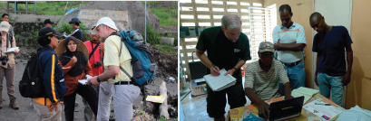
FIGURE Technical assistance in U.S. government response to natural hazard crises abroad. Left: USGS/VDAP scientist discussing with Indonesian colleagues the impacts of pyroclastic flows on villages shortly after the eruption of Mt. Merapi volcano (Indonesia) in late 2010. Right: USGS/EDAT scientist and Haitian colleagues installing a digital seismograph in a school in Port au Prince following the magnitude 7.0 earthquake in Haiti on January 12, 2010. SOURCES: Left, courtesy of Tom Uhlman, Associated Press; Right, Sue Hough, USGS.
automated earthquake information products (NEHRP, 2007, p. 35). Rapid earthquake notifications are now delivered by e-mail and text message to over 175,000 users (DOI, 2011). In addition to these features, one of the NEIC’s critical services is its automated PAGER system (for Prompt Assessment of Global Earthquakes for Response), developed with OFDA support (Box 3.9).
Volcanoes. Natural drivers for VHP international collaborations in volcano monitoring and notification (besides VDAP activities) are the geography of active U.S. volcanoes throughout a large part of the Pacific Basin (Ewert et al., 2005) and the potential impact of
BOX 3.9
USGS PAGER (Prompt Assessment of Global Earthquakes for Response)
PAGER,a developed by USGS scientists at the Survey’s National Earthquake Information Center (NEIC) in Golden, Colorado, is an automated alert system that produces information on earthquake ground shaking and loss estimates for rapid situational awareness. PAGER results, including a printable one-page report (see example below for the M 8.8 Chile earthquake in February 2010), are generally available within 30 minutes following significant earthquakes anywhere in the world—informing emergency responders, government and aid agencies, and the media (see Figure). PAGER is an example of a USGS international science activity that serves both U.S. Government international priorities and the Survey’s domestic mission in natural hazard monitoring and notification.
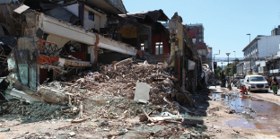
FIGURE Damage to structures in downtown Concepcion, Chile, due to the February 27, 2010, magnitude 8.8 earthquake. For significant earthquakes, PAGER information helps guide emergency responders to areas that likely require priority attention (see image and table opposite). SOURCE: Walter Mooney, USGS.
________________________
aPAGER development and maintenance are supported by the U.S. Geological Survey under the Advanced National Seismic System, with additional funding from the Global Earthquake Model project and a grant from the U.S. Agency for International Development/Office of Foreign Disaster Assistance.
volcanic ash clouds on civil aviation, maritime activities, and meteorology. Relevant VHP international activities described by Eichelberger (2011) are (1) Pacific-wide coordination with volcano and seismic observatories, aviation authorities, and meteorological agencies in Russia, Japan, and Canada; (2) assistance to Russian scientists in establishing volcanic eruption response teams for Sakhalin Island and the Kamchatka Peninsula; and (3) work with international organizations to establish ash protocols, procedures, training, and research.
Geomagnetism. Distribution of the USGS Geomagnetism Program’s 14 observatories extends to the Caribbean, Alaska, and the western Pacific Basin. The program’s work is closely
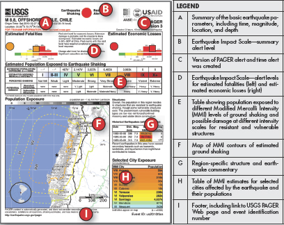
FIGURE One-page PAGER report on the February 2010 Chile earthquake. The table on the right describes the different, lettered sections of the one-page document which includes earthquake parameters, impact (fatalities and economic losses), population exposure, cities affected, and information on ground shaking.
coordinated with that of other foreign national programs through INTERMAGNET (the International Real-time Magnetic Observatory Network) and the International Association of Geomagnetism and Aeronomy (Love et al., 2008).
GLOBAL HAZARD ANALYSIS, MODELING, AND MITIGATION
Global Earthquake Model (GEM). Since 2006, USGS scientists have been involved in creating a vision and implementing a global partnership for using state-of-the-art models and tools for assessing earthquake risk worldwide to improve risk resilience and mitigation practices. The GEM16 is a global, nonprofit, public-private partnership of more than 50 companies, institutions, and organizations from 26 countries, with a Secretariat based in Pavia, Italy. Benefits to the USGS include (1) a “seat at the table” when setting global standards for seismic hazard analysis and risk assessment, (2) the opportunity to use worldwide datasets and collaborate with international scientists in developing state-of-the-art models and tools, and (3) financial support for the participation of four USGS scientists and two USGS postdoctoral fellows.17
Mitigating Volcano Hazards. In the arena of international volcano hazard mitigation, USGS/VHP collaborations include (1) formation of a tri-national consortium with Japan and Russia to promote natural hazards science relating to Japan-Kamchatka-Alaska sub-duction processes; (2) participation in the Smithsonian’s Global Volcanism Program, which seeks a better understanding of volcanoes from documentation of their eruptions during the past 10,000 years; and (3) co-convening an international forum with Italy to bring together world observatories to establish “Volcano Observatory Best Practices” (Eichelberger, 2011).
COOPERATIVE EARTHQUAKE RESEARCH PROGRAMS WITH JAPAN AND CHINA
Two prominent USGS international activities involve EHP programs and scientists in cooperative earthquake research and development with Japan (Ellsworth, 2011) and China (Mooney, 2011). These highly successful endeavors, carried out under government-to-government agreements dating back decades, involve joint panels, meetings, and workshops; collaborative research on earthquake science and disaster mitigation; exchange of researchers and seismic technologies; and access by U.S. scientists to valuable seismological datasets that otherwise might be unavailable. The USGS also assists with the bilateral operation of 10 seismic observatories in China.
__________________
16 See www.globalquakemodel.org/summary.
17 M. Blanpied, USGS, Personal communication, March 18, 2011.
VALUE TO USGS DOMESTIC MISSION
Natural hazard monitoring and the underlying science have become global. There are additional compelling arguments for the value of international activities and collaborations on earthquake, volcano, and landslide programs to the USGS domestic mission in the Natural Hazards mission area:
- International organizations and scientists drive the globalization of natural hazard monitoring, analysis, and mitigation practices and the science that underlies them (e.g., Eichelberger, 2011). USGS participation in, and in many cases leadership of, international activities relating to natural hazards help keep the USGS at the forefront of the state of knowledge and practice for domestic applications—and ensure USGS involvement in the adoption of international standards, formats, and best practices.
- The exercise of response capabilities to hazard events outside the United States greatly enhances USGS’s ability to respond effectively to similar domestic events. An example is the exercise on readiness of USGS/NEIC staff to respond to earthquakes. From 2000 to 2010, NEIC staff rapidly located and provided notification for, on average, 160 earthquakes per year of magnitude 6.0 and greater worldwide— compared to an average of 7 such earthquakes per year in the United States.18
- The development, testing, and refinement of monitoring technologies in responding to international hazard crises directly serve the associated USGS mission. The development of new volcano-monitoring techniques in responding to volcano crises overseas, together with the experience gained by USGS scientists, can be applied by VDAP to future volcanic eruptions in the United States.19 In earthquake monitoring, the escalation of NEIC activities after the catastrophic South Asian Tsunami of 2004 was a critical underpinning for the Advanced National Seismic System in the United States and led to 24/7 staffing at the NEIC, new automated response capabilities, enhanced earthquake information products such as PAGER, and robust continuity of operations.
- The participation of USGS scientists in responding to foreign hazard crises and in international collaborations has demonstrably resulted in scientific advances and lessons learned that are directly applicable in the United States. Relatively large inter-event times in the occurrence of large earthquakes and volcanic eruptions in the United States make each international case study greatly valuable for U.S. science, engineering, and hazard mitigation.
__________________
18 Based on data from the USGS Earthquake Hazards Program website (available at earthquake.usgs.gov/).
- International collaborations such as the USGS cooperative earthquake research programs with Japan and China promote the exchange of research and technologies, and give U.S. scientists access to valuable seismological data that otherwise might be unavailable.
RELEVANCE TO U.S. NATIONAL INTERESTS
The USGS National Hazards mission area is replete with international activities that are relevant and beneficial to U.S. national interests:
- Under the auspices of USAID/OFDA, USGS rapid response to foreign disasters caused by earthquakes, volcanoes, landslides, and tsunamis directly supports U.S. diplomacy and provides humanitarian benefits. USGS foreign capacity building for hazard mitigation is a typical companion activity to the USAID/OFDA emergency responses and provides the added benefit of reduced long-term need for U.S. disaster aid.
- Continuous real-time global earthquake monitoring yields critical information for rapid situational awareness. Among the recipients of rapid information from the NEIC on potentially damaging earthquakes are the U.S. Coast Guard National Command Center, White House, DOD, DHS, DOI, DOE, DOS, and Department of Transportation offices for disaster services (DOI, 2011). The immediate availability of information on significant earthquakes in Afghanistan, western Pakistan, Iran, and various theaters of U.S. military operations is of direct relevance to U.S. national interests. Data from the Global Seismograph Network also contribute to Comprehensive Test Ban Treaty monitoring.
- Partnership of the NEIC with NOAA’s Tsunami Program is vital for tsunami warnings in the Caribbean, the Pacific Basin, and other areas of U.S. government responsibility, military operations, and economic interest.
- Volcano monitoring and notification by the VHP are critical for advisories about the potential impact of volcanic ash clouds on civil and military aviation, maritime activities, and global meteorology.
- As an integral part of the U.S. government’s National Space Weather Program, the ground-based magnetic observatories of the USGS Geomagnetism Program provide essential data for warnings and forecasts associated with “space weather” (conditions relating to the dynamic interaction of the Earth’s magnetic field with the Sun). Space weather has global implications for the performance and reliability of space-borne and ground-based technological systems—ranging from satellite systems to electric power grids—and is vitally relevant to national security and the U.S. economy (Love et al., 2008; DOI, 2011).
- The USGS cooperative earthquake research programs with Japan and China support U.S. diplomacy in government-to-government protocol agreements and partnerships.
- USGS CMGP activities include membership in the U.S. Extended Continental Shelf Task Force, chaired by the DOS. The task force evaluates scientific data collected by USGS scientists to address the legally defined continental shelf that encompasses the oceanic basins in the Atlantic and Pacific (DOI, 2011).
Mission Area and Core Activities
Water plays a central role in the interactions and coupling of different components of the Earth system. The Survey addresses water in the context of local and regional hydrologic cycles that influence the way in which water can be used as a sustainable resource by providing reliable, impartial, timely information to understand the nation’s water resources, including surface and groundwater systems. The quality and quantity of water in surface and groundwater is affected by human activity and natural causes and the mission of the USGS includes activities related to monitoring water quality and quantity. The primary activities of this mission area involve collection of basic water data through long-term monitoring and project-specific data gathering, data analysis, and basic research. The Survey organizes the Water program into seven areas: (1) Groundwater Resources, (2) National Water Quality Assessment, (3) National Stream Flow Information Program, (4) Hydrologic Research and Development, (5) Hydrologic Networks and Analysis, (6) Cooperative and (7) Water Program Water Resources Research Act Program.
The executive summary of the U.S. Geological Survey Science in the Decade 2007-2017 sets forth the main direction for USGS water research under the title “A Water Census of the United States: Quantifying, Forecasting, and Securing Freshwater for America’s Future”:
The USGS will develop a Water Census of the United States to inform the public and decision makers about (1) the status of its freshwater resources and how they are changing; (2) a more precise determination of water use for meeting future human, environmental, and wildlife needs; (3) how freshwater availability is related to natural storage and movement of water, as well as engineered systems, water use, and related transfers; (4) how to identify water sources, not commonly thought to be a resource, that might provide freshwater for human and environmental needs; and (5) forecasts of likely outcomes for water availability, water quality, and aquatic ecosystem health caused by changes in land use and land cover, natural and engineered infrastructure, water use, and climate. (USGS, 2007b, p. ix)
Current International Activities
Water availability is directly linked to climate change, countries’ economies, and human existence. Climate change affects global precipitation patterns and groundwater and surface water systems. With increasing global economic interdependence, water has become an internationally-shared resource. Furthermore, human health is critically dependent on the quantity and quality of available water. Population growth and land-use changes associated with urbanization also affect the availability and management of water. Efforts to protect water as a resource and to ensure water sustainability present major scientific and technological challenges that require global knowledge.
The USGS, with its long history of research on all components of the hydrologic cycle, has a number of international research activities that contribute to understanding large river systems, flooding, groundwater availability and contamination, technology development, and aquifer assessments (particularly where aquifers cross one or more country borders). Some of the larger projects are (1) a sediment sampling and capacity-building project jointly performed with the Mekong River Commission, the USGS Louisiana Water Science Center (WSC), and the Office of Surface Water (part of the USAID/OFDA Asia Flood Network);20 (2) instrumentation training in Chile with the USGS Idaho WSC;21 (3) monitoring of Southern Africa flooding for OFDA;22 (4) development of a groundwater model for the Egyptian Nubian Sandstone Aquifer System;23 (5) groundwater resources research in West Africa (see e.g., Box 3.10); (6) Transboundary Aquifer Assessment Program, which includes collaboration with the Texas, New Mexico, and Arizona State Water Resource Research Institutes and neighboring Mexican states; and (7) a broad range of research on surface water, groundwater, and water quality as well as collaborative water monitoring projects with Canada.24
VALUE TO USGS DOMESTIC MISSION
The Water science area engages in a broad spectrum of international activities that enhance and benefit USGS domestic programs. Opportunities to study water systems and challenges abroad increase USGS capability to fulfill domestic responsibilities such as the determination of freshwater availability; evaluation of water use; identification of water
__________________
20 See “Asia Flood Network (AFN),” July 2006, available at pubs.usgs.gov/gip/130/pdf/GIP130.pdf; see also “The Office of U.S. Foreign Disaster Assistance,” October 2006, available at www.usaid.gov/our_work/humanitarian_assistance/disaster_assistance/publications/prep_mit/mods/program_updates/asia_flood_network.pdf.
21 See “USGS Hydroacoustics and Sediment Field Techniques Class, January 24–February 4, 2011, Coyhaique, Chile available at www.eula.cl/doc/Programa3.pdf.
22 See www.usaid.gov/our_work/humanitarian_assistance/disaster_assistance/countries/south_africa/template/index.html.
23 See www-naweb.iaea.org/napc/ih/IHS_projects_nubian.html.
24 J. Eimers, USGS, personal communication, September 4, 2011.
BOX 3.10
Groundwater Resource Assessment, Cape Verde Islands, West Africa
The Cape Verde Islands off the coast of West Africa host volcanic aquifers where a lens of fresh ground-water overlies a layer of brackish water at the freshwater/saltwater boundary. Groundwater is needed by the islands for human consumption, as well as for agriculture and industry. If the amount of groundwater pumped from the volcanic aquifers increases too much, the brackish water or other contaminants can be drawn up into the freshwater zone and make the aquifer unsuitable for use. Similarly, drought or climate change can affect freshwater accessibility. The USGS conducted a study on Cape Verde to evaluate baseline groundwater conditions and provide information that could be used to help develop sustainable and clean water resources.
A study of three watersheds on three of Cape Verde’s nine islands entailed data collection at varied water discharge points: wells, springs, streams, and direct submarine discharge to the ocean (see Figure). The data were used to assess groundwater budgets, travel time for rainfall through the watershed to the discharge point, depth to and vertical column of freshwater, and practical issues of potential contamination and freshwater drawdown due to pumping and the timing and potential for recharge of the freshwater aquifers.
FIGURE Hydrologic map of the Mosteiros Basin, Island of Fogo, Cape Verde Islands showing the watershed area with streams, springs, wells, and precipitation stations. Information from research in this watershed was used to identify challenges to water resource managers on Cape Verde and options for monitoring to ensure sustainable water supplies.
________________________
SOURCE: Heilwel et al. (2010).
sources; and the forecasting of outcomes for water availability and relationships to ecosystems, human health, hazard mitigation, land use practices, and development of mineral and energy resources. The Survey shares this information with other federal, state, and local water resource managers responsible for surface and groundwater management and safety, land and resource management, mine reclamation, emergency preparedness, and public health.
RELEVANCE TO U.S. NATIONAL INTERESTS
Because water is tied to climate change, human health, and geopolitical peace within and among nations, any international activities associated with the management of water are relevant to the U.S. national interest. As water becomes a scarce resource, potential exists for conflicts to arise in parts of the world that may already be experiencing dry climates or drought (e.g., Middle East, East Africa). As a preeminent science leader in water science, the USGS has a major role in serving international humanitarian needs and promoting, supporting, and implementing U.S. foreign policy concerning water. The information and expertise the USGS derives from its international water projects thus contributes directly to work conducted by the DOS, USAID, and DOD in addition to international organizations such as the United Nations.
SUCCESSFUL INTEGRATON OF EXPERTISE FROM MULTIPLE USGS MISSION AREAS: THE AFGHANISTAN PROJECT
A multicomponent, interdisciplinary research project initiated by USGS scientists in Afghanistan beginning in 2005 involved research in coal, oil and gas, minerals, natural hazards, and water (see Box 3.11), and thus engaged scientists from four of the seven USGS mission areas: Core Science Systems, Energy and Minerals, Natural Hazards, and Water. The project was conducted in cooperation with Afghan scientists and research institutions to assess the potential for resources essential to Afghanistan’s economic development and emphasized transfer of expertise in such areas as airborne geophysics and geospatial infrastructure development. A similar USGS project in Iraq, supported by the DOD Task Force for Business and Stability Operations,25 involved an assessment of nonfuel mineral and water resources of the country, assistance with development of the Iraq National Spatial Data Infrastructure, and modernization of analytical laboratories.
The considerable investment of USGS staff time in such a wide-ranging endeavor over many years cannot be overestimated. In an effort to identify critical future international science opportunities for the USGS in Chapter 4, the committee considered the challenge for Survey management and staff to allocate the scientific expertise of their personnel to
__________________
25 See iraq.cr.usgs.gov/.
BOX 3.11
USGS Projects in Afghanistan
The USGS has been active in a number of programs to assess Afghanistan’s natural resources and hazards, develop its geospatial infrastructure, and build capacity and institutions essential to the effective transfer of skills. These programs are conducted by the USGS under the auspices of the USAID and the U.S. Department of Defense Task Force for Business Stabilization Operations, and in cooperation with the Afghanistan Geological Survey (AGS) and the Afghanistan Ministry of Mines and Industry (AMMI). The long-term goals of these activities are to provide data and, more broadly, to develop institutions necessary for the reconstruction and development of Afghanistan’s economy, and to promote interest in investment and development. The activities conducted through this project address the following areas: coal resources, oil and gas resources, minerals, natural hazards, water, airborne geophysics, geospatial infrastructure development, and capacity building.
Coal resources: Afghanistan has moderate to potentially abundant coal resources. However, most deposits are relatively deep or currently inaccessible, and the scale of development has been limited. USGS scientists carried out comprehensive assessments of Afghanistan’s coal resources beginning in 2005 in cooperation with the AMMI.
Oil and gas resources: USGS scientists collaborated with Afghan scientists to characterize Afghanistan’s petroleum geology by obtaining and reviewing geochemical, geologic, seismic, tectonic, and petroleum exploration and production data. The Survey also collaborated with the AMMI to assess undiscovered oil and gas resources in northern Afghanistan.
Minerals: As part of reconstruction efforts, USAID funded a joint USGS-AGS cooperative study from 2005 to 2007 to assess nonfuel mineral resources of Afghanistan (Figure). USGS scientists worked closely with their AGS colleagues to compile information on mineral deposits, and to collect new data on potentially undiscovered deposits of non-fuel mineral resources in Afghanistan. As a result of such collaboration, a 2007 report was produced on a Preliminary Assessment of Non-Fuel Mineral Resources of Afghanistan.
Natural hazards: Afghanistan is located in a geologically active region with considerable seismic activity. With reconstruction efforts under way to rebuild infrastructure and develop natural resources, major construction plans and facility designs will need to consider the potential impact of natural hazards. Using data on the location, size, and frequency of previous earthquakes in Afghanistan and examining satellite data to locate potential fault lines, USGS researchers have created preliminary earthquake hazard maps.
Water: USGS scientists, in collaboration with the AGS and the Afghanistan Ministry of Energy and Water, collected hydrogeological data and developed data-collection networks in order to better understand and manage water resources.
Continued
Box 3.11 continued
Airborne geophysics: USGS researchers used magnetic, gravity, radiometric, and electromagnetic technologies to gather geophysical surveys and produce high-quality datasets for selected minerals. Such data can aid the AGS in their role to assist Afghanistan in business development and investment decisions.
Geospatial infrastructure development: USGS scientists have worked with the AGS and AMMI to create an integrated GIS data framework to provide state-of-the-art maps and data. Such databases capabilities can equip AGS and AMMI with the ability to assess their natural resources and restore operations for their geosciences ministries.
Capacity building: The USGS Capacity and Institution Building Project involves the transfer of knowledge, skills, and expertise from USGS scientists to their Afghan counterparts and colleagues for assisting program development in various Earth science areas.
FIGURE Mountains south of Kabul, Afghanistan. Photo taken during fieldwork for the mineral assessment portion of the project.
________________________
SOURCE: Steve Ludington, USGS (afghanistan.cr.usgs.gov/).
domestic and international projects. In the case of the Afghanistan project, benefits to both U.S. national interests and foreign policy were clearly identified by the project sponsor.
The Survey’s portfolio of current and recently completed international science activities includes widespread projects that integrate information and data on natural resources, natural hazards, ecological systems, and environmental health with which authorities and decision makers can evaluate management or policy options. The projects range from satellite monitoring of droughts and floods in foreign countries to sampling of invasive species in their countries of origin, monitoring of volcanic activity around the globe, field mapping and sampling of foreign mineral resources, and evaluation of the interaction between water quality and human health. The results from these projects not only fulfill requests from federal agencies and other organizations that call on Survey expertise, but also benefit the Survey’s domestic mission and U.S. national interests.
Although some international science projects draw on specific expertise from a single mission area—for example, the successful collaboration on earthquake research between the USGS and Japan and China—many international Earth science problems are best addressed by research that uses a systems approach. Such an approach yields more than one set of data and a broader suite of information for managers and decision makers. The Afghanistan project is one such example, as multiple datasets and analyses of a range of issues yielded a more complete foundation for addressing the country’s resource potential and resource management. Such a project demonstrates the Survey’s ability to draw on existing diverse expertise across its organization. Chapter 4 considers other types of international opportunities to make the most of USGS expertise and resources.
Alloway, B.J. 2005. Bioavailability of elements in soil. pp. 347-372. In O. Selinus, B.J. Alloway, J.A. Centeno, R.B. Finkelman, R. Fuge, U. Lindh, and P. Smedley (eds), Essentials of Medical Geology. London: Elsevier Academic Press, 812 pp.
Blanpied, M.L. 2010. Earthquake Disaster Assistance Team (EDAT): PowerPoint presentation to the Scientific Earthquake Studies Advisory Committee, Pasadena, California, November 4, 2010.
Brady, S., and J. Doebrich. 2011. “U.S. Geological Survey—Energy, Minerals, and Environmental Health.” Presentation to the Committee, February 14, 2011.
Breit, G.N., J.C. Yount, Md. N. Uddin, Ad. A. Muneem, H.A. Lowers, R.L. Driscoll, and J.W. Whitney. 2006. Compositional data for Bengal delta sediment collected from boreholes at Srirampur, Kachua, Bangladesh: U.S. Geological Survey Open-File Report 2006-1222, 51 p. Available online at pubs.usgs.gov/of/2006/1222/pdf/OF06-1222_508.pdf.
Breit, G.N., J.C. Yount, Md. N. Uddin, Ad. A. Muneem, H.A. Lowers, C.J. Berry, and J.W. Whitney. 2007. Compositional data for Bengal delta sediment collected from a borehole at Rajoir, Bangladesh: U.S. Geological Survey Open-file Report 2007-1022, 40 p. Available online at pubs.usgs.gov/of/2007/1022/.
Brennan, S.T., R.C. Burruss, M.D. Merrill, P.A. Freeman, and L.F. Ruppert. 2010. A probabilistic assessment methodology for the evaluation of geologic carbon dioxide storage. U.S. Geological Survey Open-File Report 2010–1127, 31 pp. Available at pubs.usgs.gov/of/2010/1127.
Burkett, V.R., I.L. Taylor, J. Belnap, T.M. Cronin, M.D. Dettinger, E.L. Frazier, J.W. Haines, D.A. Kirtland, T.R. Loveland, P.C.D. Milly, R. O’Malley, and R.S. Thompson. 2011. USGS global change science strategy: A framework for understanding and responding to climate and land-use change: U.S. Geological Survey Open-File Report 2010–1033, 32 pp. Available online at pubs.usgs.gov/of/2011/1033/.
CEOS (Committee on Earth Observation Satellites). 2011. CEO Members. Available online at www.ceos.org/index.php?option=com_content&view=category&layout=blog&id=30&Itemid=76 (accessed January 6, 2012).
Chowdhury, U.K., B.K. Biswas, T.R. Chowdhury, G. Samanta, B.K. Mandal, G.C. Basu, C.R. Chanda, D. Lodh, K.C. Saha, S.K. Mukherjee, S. Roy, S. Kabir, Q. Quamruzzaman, and D. Chakraborti. 2000. Groundwater arsenic contamination in Bangladesh and West Bengal, India. Environmental Health Perspectives 108: 393-397.
Cunningham, C.G., E.O. Zappettini, W. Vivallo S., C.M. Celada, J. Quispe, D.A. Singer, J.A. Briskey, D.M. Sutphin, M. Gajardo M., A. Diaz, C. Portigliati, V.I. Berger, R. Carrasco, and K.J. Schulz. 2008, Quantitative mineral resource assessment of copper, molybdenum, gold, and silver in undiscovered porphyry copper deposits in the Andes Mountains of South America. U.S. Geological Survey Open-File Report 2008-1253, 282 p.
DOI (U.S. Department of the Interior). 2008. PAR FY 2008—DOI’s Mission and Organization. Washington, DC: DOI. Available online at www.doi.gov/pfm/par/par2008/par08_1a_mission.pdf.
DOI. 2011. United States Department of the Interior Strategic Plan for Fiscal Years 2011-2016. Available online at http://www.doi.gov/bpp/data/PPP/DOI_StrategicPlan.pdf.
Duncan, D.W., and E.A. Morrissey. 2011, The concept of geologic carbon sequestration. U.S. Geological Survey Fact Sheet 2010-3122, 2 p. Available at pubs.usgs.gov/fs/2010/3122/.
Eichelberger, J. 2011. “U.S. Geological Survey—Energy, Minerals, and Environmental Health.” Presentation to the Committee on Opportunities and Challenges for International Science at the U.S. Geological Survey (USGS), February 14, Washington, DC.
Ellsworth, W.L. 2011. Overview of U.S.–Japan Cooperation in Earthquake Research Activities by the Program and Scientistis of the U.S. Geological Survey. Provided to the committee by David Applegate on March 15. 2 pp.
Ewert, J.W., M. Guffanti, and T.L. Murray. 2005. An Assessment of Volcanic Threat and Monitoring Capabilities in the United States: Framework for a National Volcano Early Warning System: U.S. Geological Survey Open-File Report 2005-1164, 62 pp. Available online at pubs.usgs.gov/of/2005/1164/ (accessed September 29, 2011).
Farmer, A., M. Abril, M. Fernandez, J. Torres, C. Kester, and C. Bern. 2004. Using stable isotopes to associate migratory shorebirds with their wintering locations in Argentina. Ornitologia Neotropical 15:377-384.
Farris, G.S. 2010. Delta research and global observation network (DRAGON) partnership. Environmental Earth Sciences 59(8):1829-1931.
Fleming, F.M., S. Brooker, S.M. Geiger, I.R. Caldas, R. Correa-Oliveira, P.J. Hotez, and J.M. Bethony. 2006. Synergistic associations between bookworms and other helminth species in a rural community in Brazil. Tropical Medicine & International Health 11:56-64.
GEO (Group on Earth Observations). 2011. Forest Carbon Tracking Portal—Task Organization. Available online at www.geo-fct.org/home/task-organisation (accessed January 6, 2012).
Gil, A.I., V.R. Louis, I.N. Rivera, E. Lipp, A. Hug, C.F. Lanata, D.N. Taylor, E. Russek-Cohen, N. Choopun, R.B. Sack, and R.R. Colwell. 2004. Occurrence and distribution of Vibrio cholera in the coastal environment of Peru. Environmental Microbiology 6:699-706.
Gundersen, L.C.S., J. Belnap, M. Goldhaber, A. Goldstein, P.J. Haeussler, S.E. Ingebritsen, J.W. Jones, G.S. Plumlee, E.R. Thieler, R.S. Thompson, and J.M. Back. 2011. Geology for a changing world 2010–2020—Implementing the U.S. Geological Survey science strategy: U.S. Geological Survey Circular 1369, 68 p. Available at pubs.usgs.gov/circ/circ1369.
Hammarstrom, J.M., G.R. Robinson, Jr., S. Ludington, F. Gray, B.J. Drenth, F. Cendejas-Cruz, E. Espinosa, E. Pérez-Segura, M. Valencia-Moreno, J.L. Rodríguez-Castañeda, R. Vásquez-Mendoza, and L. Zürcher. 2010. Global Mineral Resource Assessment—Porphyry copper assessment of Mexico. U.S. Geological Survey Scientific Investigations Report 2010-5090-A, 176 pp.
Heilweil, V.M., S.B. Gingerich, L.N. Plummer, and I.M. Verstraeten. 2010. Groundwater resources of Mosteiros Basin, Island of Fogo, Cape Verde, West Africa. U.S. Geological Survey Fact Sheet 2010-3069. Available at pubs.usgs.gov/fs/2010/3069 (accessed October 28, 2011).
IOM (Institute of Medicine). 2004. Environmental Health Indicators: Bridging the Chasm of Public Health and the Environment. Washington, DC: The National Academies Press.
Krabbenhoft, D. 2009. Landmark Study Demonstrates How Methylmercury, Known to Contaminate Seafood, Forms in the Ocean. U.S. Geological Survey Sound Waves Monthly Newsletter. Available at soundwaves.usgs.gov/2009/08/.
Long, K.R., B.S. Von Gosen, N.K. Foley, and D. Cordier. 2010. The Principal Rare Elements Deposits of the United States—A Summary of Domestic Deposits and a Global Perspective. Available online at http://pubs.usgs.gov/sir/2010/5220/ (accessed January 31, 2012).
Love, J.J., D. Applegate, and J.B. Townshend. 2008. Monitoring the Earth’s dynamic magnetic field: U.S. Geological Survey Fact Sheet 2007-3092, 2 pp., available at pubs.usgs.gov/fs/2007/3092/.
Menzie, W.D., J.J. Barry, D.I. Bleiwas, E.L. Bray, T.G. Goonan, and G. Matos. 2010. The global flow of aluminum from 2006 through 2025: U.S. Geological Survey Open-File Report 2010-1256. Available at pubs.usgs.gov/ofr/2010/1256/.
Menzie, W.D., M.S. Baker, D.I. Bleiwas, and C. Kuo, 2011. Mines and Mineral Processing Facilities in the Vicinity of the March 11, 2011, Earthquake in Northern Honshu, Japan. USGS Open-File Report 2011-1069. Available at pubs.usgs.gov/of/2011/1069/.
Mooney, W. D., 2011. 2011 Report on USGS Earthquake Research Cooperation with China and Other Countries: Report to David Applegate, USGS, dated March 24, 2011, 2 pp. [provided to the Committee by David Applegate on March 24, 2011].
NEHRP (National Earthquake Hazards Reduction Program). 2007. Annual Report of the National Earthquake Hazards Reduction Program to Accompany the President’s Budget Request to Congress for Fiscal Year 2008, 57 pp., available at fris2.nist.gov/NEHRPClearinghouse/NIST/PB2008110492.pdf.
NEHRP. 2011. Annual Report of the National Earthquake Hazards Reduction Program for Fiscal Year 2010, 86 p., available at www.nehrp.gov/pdf/2011NEHRPAnnualReport.pdf.
NRC (National Research Council). 2007. Earth Minerals and Health: Research Priorities for Earth Science and Public Health. Washington, DC: The National Academies Press.
NRC. 2008. Minerals, Critical Minerals, and the U.S. Economy. Washington, DC: The National Academies Press.
NRC. 2010. Adapting to the Impacts of Climate Change. Washington, DC: The National Academies Press.
NRC. 2011a. America’s Climate Choices. Washington, DC: The National Academies Press.
NRC. 2011b. Assessment of Impediments to Interagency Collaboration on Space and Earth Science Missions. Washington, DC: The National Academies Press.
Papoulias, D., J. Parcher, J. Stefanov, and R. Page. 2006. Interdisciplinary Science in support of Environmental Health along the United States-Mexico Border. USGS Fact Sheet 2006-3054. Available online at pubs.usgs.gov/fs/2006/3054/pdf/BEHIEnglishFS508Opt.pdf (accessed September 29, 2011).
Reynolds, A. 2011. “Grand Challenges for S&T and Engineering: USGS in Support of Diplomacy and Development.” Presentation to the Committee on Opportunities and Challenges for International Science at the U.S. Geological Survey (USGS), April 18, Washington, DC.
Robinson, M., and H. Dowsett. 2010. Why study paleoclimate?: U.S. Geological Survey Fact Sheet 2010–3021, 2 pp. Available only online at pubs.usgs.gov/fs/2010/3021 (accessed January 6, 2012).
Schenk, C.J., M.A. Kirschbaum, R.R. Charpentier, R.R., T. Cook, T.R. Klett, D.L. Gautier, R.M. Pollastro, J.N. Weaver, and M. Brownfield. 2011. Assessment of potential shale gas and shale oil resources of the Norte Basin, Uruguay, 2011. U.S. Geological Survey Fact Sheet, 2011–3100, 2 pp.
Schulz, K.J., and J.A. Briskey. 2005. Reviews of the Geology and Nonfuel Mineral Deposits of the World. U.S. Geological Survey Open-File Report 2005-1294.
SESAC (Scientific Earthquake Studies Advisory Committee). 2007. Report [for 2006] of the Scientific Earthquake Studies Advisory Committee of the Department of the Interior to the Director of the U.S. Geological Survey, 16 p., available at earthquake.usgs.gov/aboutus/sesac/reports.php.
Steffen, W., A. Sanderson, P.D. Tyson, J. Jager, P.M. Matson, B. Moore, III, F. Oldfield, K. Richardson, H. J. Schnellnhuber, B. L. Turner, II, and R. J. Wasson. 2004. Global change and the Earth system: a planet under pressure. Springer-Verlag, New York, New York, USA. 336 pp.
Stirling, I., T.L. McDonald., E.S. Richardson, E.V. Regehr, and S.C. Amstrup. 2011. Polar bear population status in the northern Beaufort Sea, Canada, 1971-2006. Ecol Appl 21(3):859-876.
Stone, R. 2004. Iceland’s doomsday scenario. Science 306:1278-1281.
Stryker, T.S., and B.K. Jones. 2010. U.S. Geological Survey disaster response and the International Charter for space and major disasters. U.S. Geological Survey Fact Sheet 2010–3062, 2 pp.
USGS (U.S. Geological Survey). 2004. USGS Invasive Species Program Five-Year Strategic Plan, 2005-2009. Available online at ecosystems.usgs.gov/invasive/documents/USGSInvasiveSpeciesProgramFiveYearProgramPlanFiscalYears2005-2009.pdf (accessed January 9, 2012).
USGS. 2005. National Ice Core Laboratory. Available online at nicl.usgs.gov/ (accessed January 6, 2012).
USGS. 2007a. Strategic science for coral ecosystems: U.S. Geological Survey Circular 1364, 23 pp. Available online at pubs.usgs.gov/circ/1364/ (accessed January 6, 2012).
USGS. 2007b. USGS Facing Tomorrow’s Challenges: U.S. Geological Survey Science in the Decade 2007-2017: U.S. Geological Survey Circular 1309. Available online at pubs.usgs.gov/circ/2007/1309/ (accessed September 29, 2011).
USGS. 2007c. Avian influenza surveillance of wild birds: U.S. Geological Survey Fact Sheet 2007-3094. Available online at www.nwhc.usgs.gov/publications/fact_sheets/pdfs/ai/AI_FS_20073094.pdf.
USGS. 2007d. Natural hazards—A national threat: USGS Fact Sheet 2007-3009, 4 p. Available online at pubs.usgs.gov/fs/2007/3009/2007-3009.pdf (accessed September 29, 2011).
USGS. 2008. Earth Science and Public Health: Proceedings of the Second National Conference on USGS Health-Related Research. USGS Scientific Investigations Report 2008-5022. Available online at pubs.usgs.gov/sir/2008/5022/ (accessed September 29, 2011).
USGS. 2009a. A Plan for a Comprehensive National Coastal Program. USGS National Coastal Program Plan – USGS Coastal and Marine Geology Program. Available online at marine.usgs.gov/coastal-plan/index.html (accessed January 6, 2012).
USGS. 2009b. Coastal-change and Glaciological Map of the Palmer Land Area, Antarctica: 1947-2009. Available online at pubs.usgs.gov/imap/i-2600-c/ (accessed January 6, 2012).
USGS. 2010a. Early Warning and Environmental Monitoring Program. Available online at earlywarning.usgs.gov (accessed January 6, 2012).
USGS. 2010b. Viral Hemorrhagic Septicemia Virus. Ecosystems – Fisheries: Aquatic and Endangered Resources Program. Available online at ecosystems.usgs.gov/faer/vhs.html (accessed January 10, 2012).
USGS. 2011a. “Science Earns Prominent Focus in the Department of the Interior’s New Five-Year Strategic Plan”: U.S. Geological Survey Press Release, January 26, 2011. Available online at www.usgs.gov/newsroom/article.asp?ID=2687 (accessed September 29, 2011).
USGS. 2011b. “Extent and Speed of Lionfish Spread Unprecedented”: U.S. Geological Survey Press Release, March 14, 2011. Available online at www.usgs.gov/newsroom/article.asp?ID=2726 (accessed January 10, 2012).
USGS. 2011c. Mineral Commodity Summaries 2011. Washington, DC: U.S. Government Printing Office. Available at minerals.usgs.gov/minerals/pubs/mcs/2011/mcs2011.pdf.
USGS. 2011d. USGS National Wildlife Health Center: Our Research. Available online at www.nwhc.usgs.gov/our_research/ (accessed January 9, 2012).
USGS. 2011e. About the USGS Coastal and Marine Geology Program. Available online at marine.usgs.gov/index.php (accessed February 2, 2012).
Withee, G.W. 2011. “USGS International Program Perspectives.” Presentation to the Committee on Opportunities and Challenges for International Science at the U.S. Geological Survey (USGS), February 14, Washington, DC.


