
ORIGIN OF THE WATER SUPPLY IMPACT STUDY
The St. Johns River Water Management District (SJRWMD or “the District”) is responsible for managing water resources in the St. Johns River basin and its surroundings—an area of 31,954 square kilometers (km2) or 12,283 square miles, which is 23 percent of the State of Florida (see Figure 1-1). The dual mission of the District is to provide water to meet the needs of human society and to protect natural systems within the basin. Each mission is challenging in its own right, and together they require careful integration of many technological, scientific, social, economic, and environmental issues.
Approximately 4.73 million people (25 percent of Florida’s population as of 2009) live in the area served by the District (Tom Bartol, SJRWMD, personal communication, 2011), which contains 110 municipalities, including the growing cities of Jacksonville, Orlando, and Gainesville. The District expects the basin population to increase to 7.2 million by 2030 (SJRWMD, 2009).
In order to meet the water supply needs of the District’s residents and its industrial and agricultural users (total water demand was 1.13 billion gallons per day in 2009—Tom Bartol, SJRWMD, personal communication, 2011), the District historically has relied on groundwater, with the upper Floridan aquifer as the primary public supply source. As a result of its ongoing planning efforts, however, the District determined that additional water demands from the increased population could not be met by further groundwater withdrawals in the basin because those supplies are reaching their sustainable limits. Indeed, groundwater withdrawals in the Central Florida Coordination Area (CFCA), near Orlando in the southwest portion of the District, are not expected to be able to satisfy new demands beyond the year 2013 (SJRWMD, 2006), and the predicted growth in withdrawals from the Floridan aquifer for most of the rest of the District is not sustainable through the 2030 planning horizon (SJRWMD, 2009). According to a District study, further water withdrawals from the aquifer would lower the level of its piezometric surface, leading to unacceptable damage to native vegetation in several areas of the basin. Alternative water supplies under consideration include three new surface water withdrawal sites in the St. Johns River and one in the lower Ocklawaha River.
In 2008 the District began a large scientific study on the potential hydrologic and ecological effects of withdrawing water from the St. Johns River and its major tributary, the Ocklawaha River. The District requested that their study, called the Water Supply Impact Study (WSIS), be reviewed as it progressed by a committee (hereafter referred to as “the Committee”)
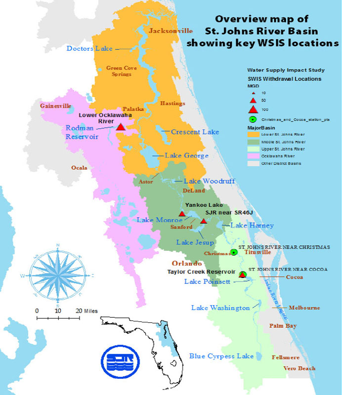
FIGURE 1-1 The St. Johns River Basin showing key features of the Water Supply Impact Study (WSIS), including the boundaries of the subbasins, major lakes along the main stem, relevant cities and towns including Cocoa and Christmas where model simulations were run, and locations of four potential surface water withdrawal sites.
SOURCE: SJRWMD (2006).
of the National Research Council (NRC). The Committee’s statement of task is in Box 1-1.
The WSIS was composed of eight major workgroups carried out by District staff scientists and aided by a suite of outside experts. The eight workgroups were focused on hydrology and hydrodynamics, wetlands, biogeochemistry, plankton, benthos, the littoral zone, fish, and wetlands wildlife. The activities of the workgroups included modeling of the relevant river basins, determining what criteria should be used to evaluate the environmental impacts of water withdrawals, evaluating the extent of those impacts, coordinating with other ongoing projects, and issuing a final report in late 2011. The Committee was asked to review scientific aspects of the WSIS, including the hydrologic and water quality modeling, how river withdrawals for drinking water would affect minimum flows and levels in the St. Johns and the Ocklawaha rivers, the impact of removing old and introducing new wastewater streams into the rivers, the impacts of water withdrawals on several critical biological targets, and the effects of sea level rise. Potential environmental impacts considered by the District that also were reviewed by the Committee include altered hydrologic regimes in the St. Johns River, increased pollutant concentrations in the river (e.g., sediment, salinity, nutrients, temperature), associated habitat degradation, and other direct effects on aquatic species due to the operation of the new water supply facilities.
The first report of the Committee (NRC, 2009a) provided comments on the initial (Phase I) work of the WSIS, which reviewed the then available hydrologic and environmental assessment tools and relevant data, and made recommendations regarding proposed work for the second phase of the WSIS. The second report of the Committee (NRC, 2009b) focused on how
Box 1-1
Statement of Task
An NRC committee overseen by the Water Science and Technology Board of the National Academies will review the progress of the St. Johns River Water Supply Impact Study (WSIS). Communities in the St. Johns River watershed in east central Florida are facing future drinking water supply shortages that have prompted the St. Johns River Water Management District to evaluate the feasibility of surface water withdrawals. At the current time, drinking water is almost exclusively supplied by withdrawals from groundwater. Reliance on groundwater to meet the growing need for public supplies is not sustainable. The St. Johns River and the Lower Ocklawaha River are being considered as possible alternatives to deliver up to 262 million gallons of water per day (MGD1) to utilities for public supply. In January 2008, the District began an extensive scientific study to determine the feasibility of using the rivers for water supply, and it has requested the advice of the National Academies as the study progresses.
The WSIS is composed of six major tasks, being carried out by District staff scientists aided by a suite of outside experts, each with national standing in their scientific discipline. These activities include modeling of the relevant river basins, determining what criteria should be used to evaluate the environmental impacts of water withdrawals, evaluating the extent of those impacts, coordinating with other ongoing projects, and issuing a final report. The NRC committee will review scientific aspects of the WSIS, including hydrologic and water quality modeling, how river withdrawals for drinking water will affect minimum flows and levels in the two rivers, the impact of removing old and introducing new wastewater streams into the rivers, the cumulative impacts of water withdrawals on several critical biological targets, and the effects of sea level rise. Potential environmental impacts being considered by the District include altered hydrologic regimes in the river, increased pollutant concentrations in the rivers (e.g., sediment, salinity, nutrients, temperature), associated habitat degradation, and other direct effects on aquatic species due to the operation of the new water supply facilities.
________________________
1 1 MGD = 0.645 cubic feet per second (cfs)
the District was responding to the recommendations in its first report, particularly on areas where the Committee concluded that additional or continued attention and work were warranted. The third report (NRC, 2010) focused on evaluating the hydrologic and hydrodynamic work performed by the District. This report, the fourth and final product of the Committee, focuses mainly on the ecological impact analyses conducted by seven environmental workgroups of the District, and provides final thoughts about the hydrologic and hydrodynamic studies and presents the Committee’s overall perspectives on the WSIS.
Several important constraints on the WSIS had to be taken into account as the committee proceeded with its review. As noted in NRC (2009a), the Ocklawaha River was not considered to the same degree as the main stem of the St. Johns River in the workgroup analyses. This is because a separate analysis of minimum flow and level requirements for the Ocklawaha is planned for the near future, during which the Ocklawaha will received the kind of intense scrutiny afforded to the St. Johns in the WSIS. Second, although large amounts of hydraulic data were available on the main stem of the river to conduct the many hydrologic analyses, data needed for the environmental impact analyses were not as readily available and in some cases were very limited. Although District scientists conducted some new monitoring and took advantage of other data collection programs, lack of data impeded the progress of certain workgroups (see Chapter 3 for details) and led to uncertainty about some of the WSIS conclusions. Finally, the WSIS focused almost exclusively on water quantity changes that would be brought about by additional water withdrawals from the St. Johns River, and as such did not directly deal with water quality issues (except for salinity changes) that would accompany the main driver for additional water withdrawals. That is, the growth in population and land use changes that would necessitate future water withdrawals from the river were not analyzed for their potential contribution to water quality degradation in the river, a fact noted in the three previous reports of this committee. The Committee understands the origins of these constraints and worked within them to be of maximum utility to the District scientists.
CONCLUSIONS OF PREVIOUS NRC REPORTS
Traditional studies undertaken by the NRC usually are in the form of a fresh investigation or review of a particular issue, program, or report. The present study was unusual (but not unprecedented) in that it was an interactive review of a significant research project as it was being conducted. During the more than 2.5-year life of the committee, it reviewed numerous documents as they were produced, met six times in person with District staff and interested parties, conducted more than a dozen conference calls, went on four extensive field trips along the river, and produced three prior reports (NRC, 2009a, b, 2010). The conclusions of the prior reports are summarized in the following discussion of overarching issues that transcend the various hydrologic and environmental analyses conducted by the District. The reader is referred to the previous three reports for details about the progress of individual workgroups.
Integration of Analyses
At the beginning of its tenure, the Committee noted that there were not clear linkages among the analyses being conducted by the various District workgroups. For example, the work
of the benthos group did not appear to be directed to the needs of the fish group, which in part depends on the expected changes in the benthic macroinvertebrate community. This problem was substantially mitigated when, following recommendations in the first NRC report, each workgroup developed a conceptual framework (analytic process flow diagram) showing not only flow within each workgroup, but required inputs of data and information from other workgroups and expected outputs to other workgroups. The Committee further recommended that interactions between any two workgroup disciplines be shown in the frameworks of both workgroups, and that the characteristics of the data and information being transferred (e.g., units of measurement, frequency, duration, etc.) be specified to improve coordination, which was subsequently achieved by all workgroups.
In NRC (2009a), the Committee expressed concern about the selection of a limited number of indicator species upon which to test effects of changes in flow and level due to water withdrawals from the river. Such narrow considerations can miss important interactions among workgroup disciplines as well as community-level impacts. The District responded by increasing the number of target species of fish, wildlife, and wetland vegetation.
Water and Nutrient Budgets
Consistent with the lack of integration among workgroups was the early absence of system-wide budgets for water and nutrients. The anticipated future growth in population not only would require increased water withdrawals, but through its impact on land use and reuse of treated wastewater effluent could potentially cause significant changes in river flow. Additionally, in early 2010 the Committee became aware of ongoing projects that will have the effect of returning flows to the upper reaches of the basin that previously had been directed out of the basin. Due to uncertainties in the timing and degree of impact of these issues, the Committee recommended that a range of future scenarios, based upon variations among these parameters, be analyzed. The District subsequently developed water budgets for locations in the middle and lower river basin under varying river flow regimes. The Committee further recommended that the District continue developing these water budgets, especially for seasons and extreme flow conditions critical to the various life stages of target indicator species. A complete water budget was developed by the District for the middle and lower river basin, in which all the conventional inflows and outflows, withdrawals, and return flows were taken into account, as discussed more fully in, Chapter 2.
The lack of a system-wide nutrient budget for the basin initially inhibited efforts to understand the impacts of future withdrawals on algal blooms in the river and especially in the larger lakes that form a major portion of the middle St. Johns River. The District thus produced nutrient budgets for some of the waterbodies in the basin that are particularly prone to algal blooms.
Dewatering of Floodplains and Wetlands
Early on, the Committee noted that detailed hydrologic and wetland modeling would be needed to determine the nature and areal extent of floodplain and wetland dewatering brought about by potential water withdrawals. The areal extent, along with the timing and duration of
events of total or partial dewatering, is critical to understanding the gross impacts on the diverse ecological web of aquatic species and those that depend on them. Efforts to this effect were constrained by the limited availability of digital elevation models (DEMs) of sufficiently fine resolution and field data supporting ecologic stress due to dewatering. The District developed refinements to their DEMs and produced hypsometric curves showing water levels in the river and adjacent floodplains and wetlands at several locations along the river. In addition, it developed the “Hydroperiod Tool,” which estimates daily water depth over an area by subtracting the ground surface elevation (obtained from a DEM) from an interpolated water surface elevation model based on river stage. The tool was used by the wetlands workgroup to determine what wetland areas would be dewatered by a potential water withdrawal and for how long.
Hydrology and Hydrodynamics
The Committee generally was satisfied with the modeling approach to predict stage, flow, and salinity at various points of interest along the river. As detailed in NRC (2010), however, it recommended that the District apply the models to more recent datasets outside the range of calibration upon which the models were developed. Also, the District was encouraged to supplement rain gage data with NEXRAD Doppler data, and to move toward 4X or higher geogrid resolution, in future work.
An unexpected result of the hydrologic and hydrodynamic modeling was the conclusion that even under the full withdrawal scenario river flows and levels would increase and not decrease as had previously been assumed. This counterintuitive finding resulted from two factors: (1) the completion of the upper basin projects, which will return some water to the river previously directed out of the basin, and (2) increased flow from impervious surfaces as a result of land use change. The Committee thus urged the District to devote as much attention to the environmental consequences of increased flows and levels as to their presumed decrease. For example, river flow in the downstream portion of the upper St. Johns (near Cocoa and Christmas) is predicted by the hydrodynamic model to increase due to increasing urbanization and as a result of the upper basin projects underway and planned for the future. The geomorphic outcome of increased stream volume, especially in smaller tributaries, could result in the deterioration of biogeochemical functioning of aquatic systems (NRC, 2010), and the District was encouraged to consider this during future work.
Projections of Future Population Growth and Land Use Changes
Population growth, which is the driver for increasing future water demand and land use changes, may not keep pace with the District’s projections. Similarly, the land use projections used by the District to develop several of its future scenarios, including the 2030 land use scenario, may prove to be less accurate than hoped for. In both cases, NRC (2010) recommended that the District acquire and use the most up-to-date projections of population growth and land use change in its periodic water supply plans and assessments.
As described in more detail in the three previous NRC reports, the St. Johns River flows in a northerly direction for most of its length—from its origins in headwater wetlands west of Vero Beach (Indian River County) until it reaches Jacksonville, where it turns east and flows another 25 miles before reaching the Atlantic Ocean at Mayport (Figure 1-1). Despite being the longest river in Florida (500 km or 310 miles), its elevation drops only about nine meters (~30 feet) from its headwaters to the ocean (an average of about 1.1 inches per mile or less than 2 cm per km), and most of the elevation drop occurs in the upper third of the river channel. As a result, a large fraction of the river is influenced by oceanic tides.
In the upper St. Johns basin, drainage activities for flood control and development of agriculture in the 20th century claimed large areas of the original floodplain and channelized parts of the river. In addition, several large areas were removed from the basin, and runoff from these areas was pumped into manmade canals that flowed directly into the Atlantic Ocean via the Indian River Lagoon. Because of environmental concerns, wetland restoration began in the upper basin in the 1980s and is still underway. Several large projects that will return tens of thousands of acres of land to the upper St. Johns River drainage basin are expected to be completed by 2015. They involve re-diverting water that currently flows into the Indian River Lagoon back to the St. Johns River.
The middle St. Johns River is a relatively short segment—approximately 60 km (37 miles)—with several large lakes and springs. It generally is defined as beginning above Lake Harney and ending below the outlet of Lake Monroe. The basin covers about 3,120 km2 (1,200 mi2), including some heavily urbanized areas northeast of Orlando. The Econlockhatchee River is a major tributary in this segment, and several large springs also contribute to the river flow. Lakes Harney and Monroe are widened areas in the main channel of the river, and Lake Jesup is a shallow off-channel lake between Harney and Monroe.
The lower St. Johns River, the longest of the three segments, is defined as the stretch of the river that is tidally influenced. It is divided into a freshwater segment, which extends downriver approximately to Green Cove Springs (river mile 48 from the ocean) and an estuarine segment, which exhibits increasing salinity as the river approaches the ocean. In turn, the freshwater segment is divided into two sub-reaches; one includes Lake George, and a second includes the freshwater reach downstream of the confluence of the Ocklawaha River. The Ocklawaha River is by far the largest tributary of the St. Johns River (and the most important in terms of water flow), draining almost one-fourth of the entire basin.
In general, the St. Johns River drainage basin has limited topographic relief, and as a result the river has extensive riparian wetlands. In the upper basin, the wetlands primarily are marshes, but in the middle and lower basins, hardwood swamps predominate. These geographic and hydrologic features provide habitat for a wide array of natural flora and fauna. The highest elevations in the basin (up to 150-200 feet above sea level) occur to the west of the river, mainly in the sand hill region east of Gainesville, which has numerous soft-water lakes, and in the Ocala National Forest in the northern part of the Ocklawaha River basin.
Although agriculture is an important activity within the St. Johns basin, a larger fraction of the drainage basin, particularly in the middle and lower basins, is forested. Much of the upland forest is in pine plantations grown for production of pulp and paper (see NRC 2010 for a summary of land use and land cover in the St. Johns basin, including the Ocklawaha sub-basin).
Cattle grazing, horse farms, citrus groves, and vegetable production (e.g., potatoes, winter vegetables) are the major farming activities.
Because of the extensive wetlands throughout the drainage basin, the St. Johns River is highly stained (brown) with humic color. Water in the river generally is quite hard—high in calcium, magnesium and alkalinity—as a result of inflows from groundwater and artesian springs connected to the calcareous Floridan Aquifer. Chloride concentrations also are high, even in the freshwater portions of the river, because of the influx of groundwater with high chloride levels. These characteristics provide challenges in treating the water for potable purposes. The river and its tributaries are rich in nutrients (nitrogen and phosphorus) as a result of runoff from agricultural and urban areas, as well as inflows of treated municipal wastewater. The nutrient levels promote luxurious growths of aquatic plants along the river edge and cause algal blooms in the major in-channel lakes, especially in the middle and lower St. Johns River.
This report is the final contribution of the NRC Committee tasked to review the WSIS. As an update of the Committee’s third report, which focused on results from the hydrology and hydrodynamics workgroup, Chapter 2 gives some final thoughts on the contributions of this workgroup, including the results of scenario analyses for the river. It also describes how the results from this workgroup were used by the seven environmental workgroups, including the issues of uncertainty and the sensitivity of the results. Chapter 3 critically evaluates the progress of the seven environmental workgroups. For each, it describes the conceptual model, summarizes the methods used by the workgroup, summarizes and analyzes the results, and makes conclusions and recommendations about the adequacy of the effort. Finally, Chapter 4 discusses a number of overarching themes, including the larger context surrounding the WSIS (such as sea level rise, dredging, water quality issues, population growth and land use change, and wastewater impacts). It makes general conclusions about the adequacy of the entire WSIS and provides some lessons to be learned for future studies on natural resource development versus impacts on environmental quality.
It should be noted that this report refers to District documents (particularly draft reports of the eight workgroups) that are likely to have been updated since the publication of this report.
NRC (National Research Council). 2009a. Review of the St. Johns River Water Supply Impact Study: Report 1. Washington, DC: The National Academies Press.
NRC. 2009b. Review of the St. Johns River Water Supply Impact Study: Report 2. Washington, DC: The National Academies Press.
NRC. 2010. Review of the St. Johns River Water Supply Impact Study: Report 3. Washington, DC: The National Academies Press.
SJRWMD (St. Johns River Water Management District). 2006. District Water Supply Plan, 2005. Technical Publication SJ2006-2. Palatka, FL: SJRWMD.
SJRWMD. 2009. Water Supply Assessment 2008. Technical Publication SJ2009. Palatka, FL: SJRWMD.


