
4
Opportunities to Improve Alignment with Decadal Survey Priorities
The inefficiencies associated with budget instability and continuing shifts in administration and congressional priorities warrant a more dynamic and robust approach to making progress on the 2007 Earth science and applications from space decadal survey vision and recommendations.1 NASA’s Earth Observing System (EOS), conceived in the 1980s and implemented in the 1990s,2 benefited from structures that existed within the NASA program that enabled senior principal investigators and engineers associated with missions and instruments to meet frequently and provide day-to-day advice to NASA managers about, for example, changes in scope and plans, new technology options, and new mission architectures. The EOS Payload Panel and Interdisciplinary Science Principal Investigators were the most visible of such groups, and their experience was built on an overall philosophy of engaging the science community and mission and instrument engineers in a coordinated way, and then using their input as a major contribution to difficult operational decisions about missions and instruments. These working groups were outside the formal broad advisory structure of the NASA Advisory Committees and the National Academies but had the benefit that they were intimately familiar with the details and overall goals of the NASA program. This committee does not see that such management structures currently exist to provide an ongoing source of broad Earth science community involvement. As a result, difficult decisions are made largely without coordinated community input, because infrequent meetings with existing high-level oversight committees cannot delve into issues at the needed level of detail.
1The 2007 decadal survey recommended that NASA “[i]mplement a system-wide independent review process that permits decisions regarding technical capabilities, cost, and schedule to be made in the context of the overarching science objectives. Programmatic decisions on potential delays or reductions in the capabilities of a particular mission would be evaluated in light of the overall mission set and integrated requirements” (p. 11). This statement is reiterated here in the form of a recommendation. See National Research Council, Earth Science and Applications from Space: National Imperatives for the Next Decade and Beyond (The National Academies Press, Washington, D.C., 2007), which included guidance in Box 3.4 for the case of budget shortfalls.
2See CIESIN, “EOS Program Chronology,” available at http://www.ciesin.org/docs/005-089/005-089art2.html, reproduced from NASA, Earth Observing System (EOS) Reference Handbook, G. Asrar and D.J. Dokken, eds., NASA Earth Science Support Office, Document Resource Facility, Washington, D.C., 1993.
An overarching cross-mission science and applications coordination effort would help ensure that programmatic decisions on potential delays or augmentations/reductions in the capabilities of a particular mission would be evaluated in light of the overall mission set and integrated requirements rather than as “one off” decisions.3 The science and applications coordination effort should include appropriate interaction with the already-established system engineering working group4 and mission system engineering teams to stay apprised of cross-mission areas of mutual interest5 and should be conducted in an ongoing manner as science requirements and mission designs and costs evolve—with the participation of other agencies and international partners/stakeholders when appropriate.
ESTABLISHING AND MANAGING MISSION COSTS
As discussed in Chapter 3, the 2007 decadal survey report put forth mission concept descriptions and notional costs that were intended mainly to set targets for each mission that are consistent with an overall program that is affordable while denoting the relative cost of one mission with respect to another, which factored into mission priority and phasing.6 After release of the survey, teams were formed by NASA to further develop each of the recommended mission concepts. Based on discussions with the director of the Earth Science Division (ESD) and individual mission team members, the committee learned that teams operated primarily in a “requirements-gathering” mode, unconstrained by even notional cost targets.7 Unfortunately, this approach created an atmosphere in which science requirements and scope tended to grow, as did cost estimates.8 Furthermore, there was apparently insufficient consideration given to the effect of individual mission cost growth on the entire queue of recommended missions.
3This cross-mission science and applications coordination effort could, for example, encourage studies and trades across missions where synergies anticipated in the survey report might not be readily realized in the mission concepts as presented, or within available resources. Indeed, the need for further optimization was recognized by the survey authors, who stated, “The selected missions reflect the panels’ prioritization of scientific observations but are not the result of an exhaustive examination of the trade-offs across the entire range of potential missions. Clearly, more detailed cost estimates are needed that examine the full range of mission tradeoffs….” (National Research Council, Earth Science and Applications from Space: National Imperatives for the Next Decade and Beyond, 2007, p. 43.)
4The Earth Systematic Missions Program Office has established a systems engineering working group with representatives from each center.
5Science stakeholder participation in the A-Train Constellation Mission Operations Working Group is an example of such effective interaction.
6The decadal survey cost estimation process and purpose are described further in Box 2.3 in the 2007 report: “Nevertheless, the estimates provided in this study set targets for each mission that are consistent with an overall program that is also affordable. The panels recognize that the missions afforded under the estimated costs will be ones that respond to the main scientific requirements articulated by the panels in Chapters 5 through 11, but not necessarily all of the desired requirements. The selected missions reflect the panels’ prioritization of scientific observations but are not the result of an exhaustive examination of the trade-offs across the entire range of potential missions. Clearly, more detailed cost estimates are needed that examine the full range of mission trade-offs. Where possible within budget constraints, augmentation of the specified set of science observations with additional desired observables should be considered; however, NASA and the scientific community must avoid ‘requirements creep’ and the consequent damaging cost growth” (National Research Council, Earth Science and Applications from Space: National Imperatives for the Next Decade and Beyond, 2007, p. 43).
7The discussion between the ESD director and the committee took place on April 28, 2011, during the committee’s first meeting in Washington, D.C. Discussions with mission team members took place during the committee’s first and second meetings, the latter of which was held on July 6-8, 2011.
8The bulk of early formulation funding went directly to the science community to support “requirements gathering.” Without pushback from engineering or cost experts, requirements can accumulate with minimal challenges or controversy. The sense is that the science is paramount and, as long as the mission is far in the future, anything is considered possible. However, this approach nurtures the development and maintenance of sometimes inappropriately high expectations and can result in untenably high costs and high cost risk.
The success of all missions is ultimately critically dependent on an end-to-end partnership between the science team and the engineering team to ensure that an iterative process emerges that continuously balances all of a mission’s constraints, both technical and programmatic. Instead of a process that starts with gathering science requirements and then determining the resulting cost of a derived mission, those with science, engineering, systems engineering, and cost expertise should all be involved from the beginning. By understanding the source of various requirements, their relative priorities, and the consequences of designing to satisfy the requirements, engineers are better able to push back if incremental science requirements will drive up a mission design’s cost or risk, identifying the “knees in the curves,” and interacting with the science stakeholder community in a productive and iterative fashion toward development of a truly optimized design.9 By fully sensitizing all involved to the factors associated with implementing and costing a mission, this interaction can help minimize the “sticker shock” associated with individual missions when they are handed off from the broader science community to the mission implementers.
Early establishment of cost and schedule constraints would allow an iterative process to emerge that could continuously balance all of the mission constraints within a known and achievable funding envelope, leading to a more robust yet affordable implementation. This way, the team can be focused on maximizing science return on investment rather than attempting to craft a “perfect” yet unaffordable mission. The committee found that process transparency is essential to ensure that the implementation of the decadal survey is regarded as a community-driven effort and not one driven by local or vested interests, and thus offers the following recommendation:
Recommendation:
• NASA’s Earth Science Division (ESD) should implement its missions via a cost-constrained approach, requiring that cost partially or fully constrain the scope of each mission such that realistic science and applications objectives can be accomplished within a reasonable and achievable future budget scenario.
Further, recognizing that survey-derived cost estimates are by necessity very approximate and that subsequent, more detailed analyses may determine that all of the desired science objectives of a particular mission cannot be achieved at the estimated cost,
• NASA’s ESD should interpret the 2007 decadal survey’s estimates of mission costs as an expression of the relative level of investment that the survey’s authoring committee believed appropriate to advance the intended science and should apportion funds accordingly, even if all desired science objectives for the mission might not be achieved.
To coordinate decisions regarding mission technical capabilities, cost, and schedule in the context of overarching Earth system science and applications objectives, the committee also recommends that
• NASA’s ESD should establish a cross-mission Earth system science and engineering team to advise NASA on execution of the broad suite of decadal survey missions within the interdisciplinary context advocated by the decadal survey. The advisory team would assist NASA in coordinating
9End-to-end system simulations performed prior to Preliminary Design Review can help to quantitatively identify the cost/benefit ratios for the baseline design, as well as a range of alternatives.
decisions regarding mission technical capabilities, cost, and schedule in the context of overarching Earth system science and applications objectives.10,11
The roots of international partnerships and joint missions to observe Earth from space come from the International Geophysical Year in the late 1950s. Throughout the 1960s and 1970s and peaking with the Global Weather Experiment (GWE) and the World Weather Watch in 1979, both bilateral and multinational space missions for weather, climate, and ocean observations became the norm. These international activities are fostered by the International Council of Scientific Unions (ICSU), the World Meteorological Organization of the United Nations, and others. NASA and other national space agencies, as well as the National Oceanic and Atmospheric Administration (NOAA) and other national weather/climate agencies, have decades of experience with joint space missions as well as hosting another nation’s instruments on their spacecraft.
On June 28, 2010, President Obama issued the new National Space Policy. One of the policy’s goals is expanded “international cooperation on mutually beneficial space activities to: broaden and extend the benefits of space; further the peaceful use of space; and enhance collection and partnership in sharing of space-derived information.”12 The policy further calls on departments and agencies to “identify potential areas for international cooperation that may include … Earth science and observation; environmental monitoring; … geospatial information products and services … disaster mitigation and relief ….”; and other areas, as well. It further looked to “promote appropriate cost- and risk-sharing among participating nations in international partnerships; and augment U.S. capabilities by leveraging existing and planned space capabilities of allies and space partners.” Clearly, this policy seeks to mitigate U.S. budget shortfalls through a non-zero-sum game, enabling increased accomplishment through international cooperation. International joint missions, hosted instruments, shared data, and coordinated satellite constellations are all becoming new realities. As such international cooperation spreads into all areas of Earth science it becomes natural and essential to include significant specific international partnerships in the planning and implementation of any Earth science and applications from space decadal survey. Several examples of international collaborations are provided below to illustrate the variety of scopes and scales such collaborations can involve.
• The successful June 10, 2011, launch and orbital insertion of the Aquarius/Satélite de Aplicaciones Científicas (SAC)-D mission to globally measure sea-surface salinity features an international partnership between NASA and Argentina’s space agency, Comision Nacional de Actividades Espaciales (CONAE).13 The 3-year mission (the fourth of this collaboration) includes a NASA instrument, an Argentine spacecraft, and a launch from Vandenberg Air Force Base on a Delta II launch vehicle.
10The team, similar to the Payload Advisory Panel established by NASA to assist in implementation of its Earth Observing System (EOS), would draw its membership from the scientists and engineers involved in the definition and execution of survey missions as well as the nation’s scientific and engineering talent more broadly. (The Payload Advisory Panel was composed of the EOS Interdisciplinary Science Investigation principal investigators and was formally charged with examining and recommending EOS payloads to NASA based on the science requirements and priorities established by the Earth science community at large.) See NASA, Earth Observing System (EOS) Reference Handbook, G. Asrar and D.J. Dokken, eds., NASA Earth Science Support Office, Document Resource Facility, Washington, D.C., 1993.
11The committee believes that NASA is best positioned to determine whether this advisory panel should be constituted as a Federal Advisory Committee Act-compliant advisory body.
12See http://www.whitehouse.gov/sites/default/files/national_space_policy_6-28-10.pdf.
• FORMOSAT-3/COSMIC, the joint Taiwan/U.S. science mission for weather, climate, space weather, and geodetic research, was launched on April 14, 2006. The mission, which includes six identical microsatellites launched together on a Minotaur vehicle, currently provides thousands of daily radio occultation profiles that yield accurate and precise information on temperature, water vapor, and electron density.14 COSMIC (Constellation Observing System for Meteorology, Ionosphere and Climate) has contributed significantly to ionospheric, stratospheric, and tropospheric sciences and to applications for space weather, weather prediction, and climate science.15 The FORMOSAT-7/COSMIC-2 planned joint mission (Appendix D), however, is at risk because of a lack of NOAA funding commitment to match Taiwan’s $160 million commitment and a similar level of support from the U.S. Air Force.
• The joint Japanese-U.S. Global Precipitation Mission (GPM)—a joint NASA/JAXA mission—is to be launched in 2013 (Figure 4.1). For this mission Japan provides the Dual-frequency Precipitation Radar (DPR) instrument and HII-A launch vehicle, and the United States provides the GPM Microwave Imager (GMI) instrument, the spacecraft, and other system components. Major international partners also include France and Canada.
• NASA and the German Aerospace Center (DLR) jointly developed the twin-satellite Gravity Recovery and Climate Experiment (GRACE) mission (launched in March 2002) and are continuing to cooperate throughout its operational phase. NASA and DLR plan to fly a GRACE follow-on continuity mission to extend the measurement of changes in microgravity due to variability (e.g., depletion, recovery) in continental aquifers, polar ice mass changes, and so on.16
• The Initial Joint Polar System Agreement,17 made between NOAA/National Environmental Satellite, Data, and Information Service (NESDIS) and the European Organisation for the Exploitation of Meteorological Satellites (EUMETSAT) in 1998, created the framework for two polar-orbiting satellite systems and their respective ground systems. This agreement—whereby EUMETSAT flies the mid-morning weather and environmental platform, and NOAA flies in the early afternoon—continues to work exceedingly well to provide meteorological and environmental forecasting and global climate monitoring services worldwide.18 It is sustained through ongoing working groups, cross-participation in satellite meteorology, oceanography, and climate conferences, and the dedication of a small number of individuals in the United States and Europe. NOAA/NESDIS and EUMETSAT are working to establish the renewed Joint Polar System by 2018.19
Recent developments in bilateral and multilateral sharing of Earth remote sensing data have been encouraging. In a continuation of its policy of open access to science data, the United States has made Landsat data widely available, and the number of data downloads, users, and applications has increased from thousands to millions.20 Working through the Global Climate Observing System (GCOS) and the Committee on Earth Observations Satellites (CEOS), NASA and NOAA coordinate activities to ensure international coordination of long-term mission planning activities and progress on issues of mutual interest. Several agreements between NASA and NOAA with international groups will bring Japanese Global Change
14See http://www.cosmic.ucar.edu/index.html.
15See http://www.atmos-meas-tech.net/4/1077/2011/amt-4-1077-2011.html.
16See http://www.csr.utexas.edu/grace/. The GRACE follow-on mission is a climate continuity mission called for in NASA, Responding to the Challenge of Climate and Environmental Change: NASA’s Plan for a Climate-Centric Architecture for Earth Observations and Applications from Space, June 2010, available at http://science.nasa.gov/media/medialibrary/2010/07/01/Climate_Architecture_Final.pdf.
17See http://www.eumetsat.int/Home/Main/AboutEUMETSAT/InternationalRelations/KeyPartners/SP_1225965119191.
18See http://projects.osd.noaa.gov/IJPS/.
19See http://www.eumetsat.int/Home/Main/AboutEUMETSAT/InternationalRelations/KeyPartners/SP_1225965119191.
20U.S. Geological Survey, “Free Landsat Scenes Go Public by the Million,” USGS Newsroom, August 20, 2009, available at http://www.usgs.gov/newsroom/article.asp?ID=2293&from=rss_home.
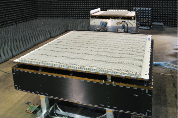
FIGURE 4.1 The Dual Frequency Precipitation Radar instrument that will fly on the Global Precipitation Measurement mission. SOURCE: Copyright © Japan Aerospace Exploration Agency.
Observation Mission-Climate (GCOM-C) and GCOM-W (water) data to the United States as well as the EUMETSAT MetOp data. In addition, the 2007 survey’s Surface Water and Ocean Topography (SWOT) mission is being considered as a multidisciplinary cooperative international effort that builds on a long-lived and successful U.S. and French partnership. The SWOT satellite mission will expand on previous altimetry flights (e.g., TOPEX/Poseidon) through wide-swath altimetry technology to achieve complete coverage of the world’s oceans and freshwater bodies with repeated high-resolution elevation measurements.21
International collaborations are well aligned with the first recommendation of the 2007 decadal survey that “the U.S. government, working in concert with … international partners, should renew its investment in Earth-observing systems and restore its leadership in Earth science and applications” (p. 2). As noted in the 2011 National Research Council (NRC) report Assessment of Impediments to Interagency Collaboration on Space and Earth Science Missions:22
21See http://swot.jpl.nasa.gov/mission/.
22National Research Council, Assessment of Impediments to Interagency Collaboration on Space and Earth Science Missions, The National Academies Press, Washington, D.C., 2011.
A prerequisite for a successful international collaboration is that all parties believe the collaboration is of mutual benefit.… agreements should not be entered into lightly and should be undertaken only with a full assessment of the inherent complexities and risks. (p. 2)
Current opportunities for new partnerships might be found, among others, with the European EarthCARE joint European-Japanese mission that observes the climate-related interactions among cloud, radiative, and aerosol processes; the Atmospheric Laser Doppler-Lidar Instrument (Aladin) on the Atmospheric Dynamics Mission-Aeolus (ADM-Aeolus), with DLR for a Tandem-L InSAR mission.
Finding: NASA has made considerable efforts to secure international partnerships to meet its science goals and operational requirements.
ALTERNATIVE PLATFORMS AND FLIGHT FORMATIONS
In addition to traditional launches on dedicated, large spacecraft, a number of promising alternative platforms and observing strategies are emerging and being proven. These include flights on piloted23 and/or unpiloted aircraft, hosted payloads on commercial satellites,24 small satellites, the International Space Station, and the flight of multiple sensors in formations rather on a single bus.25 These alternative mission concepts can offer considerable implementation flexibility.
Instrument accommodation on balloons, piloted aircraft, and unpiloted aerial vehicles (UAVs) provides a rapid and cost-effective means for proof-of-concept studies, technology maturation, or actual research/operational use. Their utility was recognized by NASA in the first Earth Venture (EV-1) announcement of opportunity, from which a diverse portfolio of five science investigations was selected.26
Also referred to as secondary payloads, hosted payloads take advantage of available capacity on commercial (e.g., communications) satellites to accommodate communications or science instruments. The Department of Defense (DOD) has been successful in using hosted payload concepts to lower program costs. NASA’s recently released draft solicitation for the first Earth Venture-Instruments (EV-I) calls for principal investigators to propose instruments for hosting on platforms of opportunity, which can include commercial satellites, opening the door to leveraging hosted payload capacity to advance NASA Earth science.27
Small satellites, notionally those with spacecraft masses less than 500 kg,28 can enable rapid development strategies (less than 36 months) that lower development costs. A 2000 NRC report, The Role of Small Satellites in NASA and NOAA Earth Observation Programs, provides an analysis of the role of small satel-
23See http://www.nasa.gov/mission_pages/icebridge/index.html.
24See http://hostedpayloadalliance.org/.
25See http://www.nasa.gov/mission_pages/a-train/a-train.html.
26See http://www.nasa.gov/home/hqnews/2010/may/Hq_10-127_Venture_Program.html.
27See http://essp.larc.nasa.gov/EV-I/.
28The ~450 kg OCO (and OCO-2) and the 70 kg COSMIC satellites are examples of small satellites.
lites in Earth observation, particularly in the context of complementing (not replacing) larger missions.29 Especially when configured with single sensors, small satellite missions can add significantly to architectural and programmatic flexibility. An emphasis on smaller platforms also potentially reduces cost through the use of smaller and cheaper launch vehicles, including opportunities for launching multiple payloads on a single launch vehicle, and “piggyback” launches, using excess capacity on larger launch vehicles.
In 2007, the Hyperspectral Imager for the Coastal Ocean (HICO) was manifested for the Japanese Experiment Module-Exposed Facility (JEM-EF) on the International Space Station (ISS), and installed on orbit on September 24, 2009. HICO was sponsored by the Office of Naval Research (ONR) to “develop and operate the first Maritime Hyperspectral Imaging from space.”30 HICO was integrated and flown under the direction of DOD’s Space Test Program. One of the HICO mission requirements was to “demonstrate new and innovative ways to develop and build the imaging payload (reduce cost, reduce schedule).”31 The sensor was delivered 16 months after project start and was installed within a total time of 3 years of its proposal. HICO has since met its demonstration requirement. HICO’s implementation demonstrated that the ISS is a viable platform for demonstrations of Earth observing technologies and Earth observations.32 (See Figure 4.2.) Another instrument scheduled for manifestation on the ISS is NASA’s Stratospheric Aerosol and Gas Experiment III-ISS (SAGE III-ISS) to measure atmospheric ozone, water vapor, and aerosols. SAGE III is scheduled for launch in 2014 on a SpaceX rocket from NASA Kennedy Space Center.33
Formation flying can deliver multiple benefits, not the least of which is the ability to flexibly combine (and maintain over time) multiple, synergistic, and multisensor measurement types.34 Advances in both station-keeping ability and coordination protocols now make it possible to achieve formation flight with a diverse set of spacecraft, whether launched simultaneously or years apart, including the large EOS observatories, small satellites, and co-manifested satellites. Constellations may remain in place beyond the lifetime of individual satellites if appropriate planning and funding remain in place. The Afternoon Constellation (A-Train) continues to exemplify the best of international scientific cooperation and coordination35 and can provide valuable experience, best practices, and lessons learned for future constellation efforts (e.g., potential establishment of a constellation based on the Joint Polar Satellite System, JPSS). Coordinated formation flight efficiencies can include the synergies of complementary measurements, where the assigned degree
29National Research Council, The Role of Small Satellites in NASA and NOAA Earth Observation Programs, National Academy Press, Washington, D.C., 2000.
30M.R. Corson (Naval Research Laboratory) and C.O. Davis, (Oregon State University), “HICO Science Mission Overview,” available at http://hico.coas.oregonstate.edu/publications/Davis_HICO_for%20IGARSS.pdf, p. 22.
31Corson and Davis, “HICO Science Mission Overview,” p. 7.
32See http://www.ioccg.org/sensors/Davis_HICO_IOCCG-15.pdf.
33See http://www.nasa.gov/topics/earth/features/sage3.html.
34Formation flight can provide a much clearer way of quantifying errors in parameter estimation and identifying major biases/flaws in past data derived from single sensors. For example, the combined cloud information from CALIPSO and CloudSat has exposed significant biases in interpretation of ISCCP (International Satellite Cloud Climatology Project) global cloudiness, the combination of CALIPSO and CloudSat has led to a new and more accurate way of retrieving aerosol optical depth, and CALIPSO has yielded powerful new information about polar stratospheric clouds, and so on.
35See http://atrain.nasa.gov/, http://www.nasa.gov/mission_pages/a-train/a-train.html, and http://eospso.gsfc.nasa.gov/eos_observ/pdf/Jan-Feb_2011_color_508.pdf.

FIGURE 4.2 HICO image of the Straits of Gibraltar, December 5, 2009. SOURCE: Naval Research Laboratory; available at http://hico.coas.oregonstate.edu/gallery/gallery-scenes.shtml.
of simultaneity is based on position within the train; train permanence (with its composition changing over time);36 a ready mechanism for international cooperation; technology insertion, with research and operational technologies operating side by side; the avoidance of engineering complexities and management difficulties associated with integration on a common bus; and a more agile and cost-effective replacement of individual sensors. Also important is the role of formation flight in enabling Earth system science by moving away from a single parameter and sensor-centric approach toward a systems approach that ties observations together to study processes important to understanding Earth-system feedbacks.37
Finding: Alternative platforms and flight formations offer programmatic flexibility. In some cases, they may be employed to lower the cost of meeting science objectives and/or maturing remote sensing and in situ observing technologies.
36S.W. Boland, M.D. Garcia, M. Vincent, S. Hu, P.J. Guske, and D. Crisp, “Ground Track Selection for the Orbiting Carbon Observatory-2 Mission,” American Geophysical Union Fall Meeting 2011, abstract #A33C-0242, American Geophysical Union, 2011.
37For example, the combination of water vapor and temperature from AIRS, together with proper cloud screening tested with other data, has provided insight on the strength of water vapor feedback; the combination of MODIS, AMSR-E, and CloudSat has revealed new insights on rain-forming processes, thus exposing major biases in climate model parameterizations; and the combination of AIRS, CloudSat, and CERES is being used to understand the sources of seasonal loss of sea ice in the Arctic.


