
Integrated Climate Observing System and Earth System Analysis
Observations are critical for monitoring and advancing understanding of the processes driving the variability and trajectory of the climate system. The evaluation and improvement of climate and Earth system models is thus fundamentally tied to the quality of the observing system for climate. The observational assessment of model performance is an important prerequisite for credible climate predictions and projections and for articulating their uncertainties. Climate observations and model assessment have become increasingly important and urgent because climate change is progressing rapidly.
A longstanding issue is the adequacy of the observational record for the purpose of model evaluation and advancement. Numerous Earth observations are made, but many are not of sufficient quality to evaluate models or meet other climate needs (e.g., NRC, 2007). In the atmosphere, most observations are made to initialize weather forecasts. Because the amplitude of weather fluctuations is large, high measurement accuracy and low bias have historically not been a priority. In contrast, climate change must discern relatively small changes over time, which requires stable calibrated measurements of high accuracy. Knowing how the measurements of today relate to those of years or decades ago is a very important component of climate science.
Another challenge for a climate observing system is that monitoring climate involves measuring many more variables than for monitoring weather. Space and time scales are also more extreme for climate—clouds vary rapidly while ice sheets and the deep ocean vary very slowly. The shortage of reliable and consistent data on the interactions between climate, environmental systems, and humans limits our ability to understand and model how humans affect climate and vice versa.
Observational data sets contain inherent limitations such as measurement uncertainties, gaps in spatial or temporal coverage, and the lack of continuity of calibrated records over extended periods of time (e.g., NRC, 2004; Trenberth et al., 2006). A proliferation of observational data sets, including retrospective reanalysis products and newly available satellite measurements, has enhanced understanding of the climate system
and its processes but has also led to a bewildering number of similar data sets. This proliferation thus demands an assessment of the various observational products and their usefulness for different purposes, as well as documentation of the differences and uncertainties among the data sets. Users, including modelers, often do not have sufficient information to appreciate the strengths and weaknesses of different data products describing the same variable, and how they may be reliably used.
The high number of important climate variables suggests there is a need to prioritize observational requirements within the climate observing system. Such prioritization is fraught with difficulty, however, because of the underlying assumptions and the fact that observations are used for multiple purposes. The Observing System Simulation Experiment (OSSE) methodology can potentially be used to advance the rigor of both climate model testing as well as climate observations (e.g., Norton et al., 2009). Although model spatial resolution and errors currently limit the utility of OSSEs, OSSEs will become more effective and powerful at prioritizing climate observations as models improve.
Although the existing collection of in situ observations covers most high-priority and currently feasible measurements, their spatial and temporal coverage is incomplete, and many improvements to the current climate observing system can be envisioned. Such improvements would be based on technical innovations in measurement techniques, the recognition of new needs for observations, and improved integration of variables for societally relevant topics. There is also a general need for integration and synthesis of satellite and in situ observations, which is partly met by reanalysis. Observations from multiple sources are not necessarily redundant, because they can complement each other and allow calibration and validation.
Some observation systems critical for model evaluation and improvement are at risk, either because they require substantial investments that cannot be done incrementally, or because budget constraints and aging equipment have gradually reduced capabilities or data quality to unacceptable levels. While nations have continued to recognize the importance of climate observations, for example through acceptance of the Global Climate Observing System (GCOS) Implementation Plans, in many cases funding commitments have not yet been made by GCOS member nations to provide or improve key components of the climate observing system. The risk of major satellite and in situ observing system holes is already present, and it may well grow in the future. As discussed by Trenberth et al. (2011), there are many good aspects of the current GCOS, but much remains to be done in order to provide the climate-quality products required to develop and test the next generation of climate models and Earth system models (ESMs). Process-oriented observations require further attention
and prioritization as well. These and other issues are explored in more detail in the following sections.
STATUS OF SYSTEMATIC CLIMATE OBSERVATION
A thorough summary of the organizational framework and status of systematic climate observations, including by satellite, is provided by Trenberth et al. (2011). The lead international organization for advisory oversight of systematic climate observations is GCOS.1 Its goal is to provide comprehensive information on the total climate system, involving a multidisciplinary range of physical, chemical, and biological properties, and atmospheric, oceanic, hydrologic, cryospheric, and terrestrial processes. One of the most important roles of GCOS is to produce regular assessments of the adequacy of climate observations, including suggestions for needed improvements. Recent GCOS reports provide an excellent reference point for discussing the status of climate observations.
Among other points, GCOS (2009) concluded that developed countries had improved many of their climate observation capabilities, but there was little progress in ensuring long-term continuity for several important observing systems and in filling gaps in the in situ observing networks, with some evidence of decline. On the positive side, GCOS (2009) concluded both operational and research networks and systems were increasingly responsive to needs for climate data and information, including the need for timely data exchange, and that space agencies had improved mission continuity observational capability, data reprocessing, product generation, and access. Overall, GCOS judged that the international climate observing system has progressed significantly, but it still falls short of meeting all the climate information needs of the United Nations Framework Convention on Climate Change (UNFCCC) and broader user communities.
The Third World Climate Conference (WCC-3 in 2009) underscored the importance of systematic observations (Karl et al., 2010; Manton et al., 2010) and recommended strengthening GCOS in several ways. Of particular note were the WCC-3 recommendations to sustain the established in situ and space-based components of GCOS; enhance existing observing systems (e.g., fill gaps in spatial coverage, improve measurement accuracy and frequency, and establish reference networks); apply the GCOS
___________________
1http://www.wmo.int/pages/prog/gcos/ (accessed October 11, 2012).
Climate Monitoring Principles (GCMPs2); improve the operation and planning of observing systems; and rescue, exchange, archive, and catalog data, and recalibrate, reprocess, and reanalyze long-term records, working toward full and unrestricted access to data and products. High priority in WCC-3 was also given to the observational needs for adaptation planning and to assisting developing countries to maintain and strengthen their observing networks.
The 2010 update (GCOS, 2010) also noted advances in observational science and technology, an increasing focus on adaptation, and the demand to optimize mitigation measures. It reaffirmed the importance of the GCMPs, emphasizing the need for continuity and stability of measurements. GCOS (2010) also provided a current listing of “essential climate variables” (ECVs) (Table 5.1) and called for collocated measurement of ecosystem variables along with the ECVs that influence or are influenced by them.
Finding 5.1: Observational networks and systems are increasingly responsive to needs for climate data and information, but still fall short of meeting information needs for climate and Earth system modeling.
CHALLENGES, GAPS, AND THREATS
Observational Needs for Earth System Models
The climate modeling enterprise differs from operational weather forecasting in several significant ways. With respect to observations in support of modeling, one important difference is the need for long-term, accurate measurements of a broad range of Earth system components, including the oceans, land surface, biosphere, and cryosphere as well as the atmosphere (GCOS, 2010, Table 1). The list of ECVs may increase as climate models embrace increasingly more sophisticated treatments of the Earth system (e.g., ice sheets, permafrost, land-surface hydrology, and the carbon cycle). Because coupled climate models can drift if one component of the system is poorly represented, subsystems that are poorly initialized, modeled, or constrained can compromise the full climate solution. Moreover, feedbacks that are often controlled by small-scale processes may cause such errors to grow and propagate in long-term (i.e., multidecadal) climate projections.
___________________
2http://www.wmo.int/pages/prog/gcos/index.php?name=ClimateMonitoringPrinciples (accessed October 11, 2012).
TABLE 5.1 Essential Climate Variables (ECVs) That Are Both Currently Feasible for Global Implementation and Have a High Impact on UNFCCC Requirements (GCOS, 2010)
| Domain | Essential Climate Variables | |
| Atmospheric (over land, sea, and ice) | Surface: Air temperature, wind speed and direction, water vapor, pressure, precipitation, surface radiation budget. Upper-air: Temperature, wind speed and direction, water vapor, cloud properties, Earth radiation budget (including solar irradiance). Composition: Carbon dioxide, methane, and other long-lived greenhouse gases; ozone and aerosol, supported by their precursors. |
|
| Oceanic | Surface: Sea-surface temperature, sea-surface salinity, sea level, sea state, sea ice, surface current, ocean color, carbon dioxide partial pressure, ocean acidity, phytoplankton. Subsurface: Temperature, salinity, current, nutrients, carbon dioxide partial pressure, ocean acidity, oxygen, tracers. |
|
| Terrestrial | River discharge, water use, ground water, lakes, snow cover, glaciers and ice caps, ice sheets, permafrost, albedo, land cover (including vegetation type), fraction of absorbed photosynthetically active radiation, leaf area index, above-ground biomass, soil carbon, fire disturbance, soil moisture. | |
For observational data sets to be most useful to climate model validation and verification, or as boundary and initial conditions for modeling studies, most climate fields need to be gridded and reasonably complete (i.e., without major geographic and temporal gaps). The spatial density of required data depends on the application and on the resolution of climate models in the coming decades (see below). As improved understanding and model representation of physical processes and feedbacks involved in regional climate variability elevates in importance, more detailed and complete regional observations will be required.
Specific examples of ECVs that are not routinely or globally available at present include sea-ice thickness, deformation, drift and export, soil moisture, land carbon stocks, the surface radiation budget, and stratospheric water vapor. Recommended monitoring strategies for these and many other climate variables are provided in Karl et al. (2010) and GCOS (2010). In other cases, climate variables may be well monitored at present, but accuracy and continuity of the observations must be ensured, as well as calibration and homogenization of data products that originate from different platforms or instruments. All these data characteristics are essential to evaluation of temporal trends, which provide some of the main “targets” for climate modeling.
Process Studies
The number of physical processes included in climate and Earth system models is increasing, and those occurring below the model grid scale are typically parameterized. The observations needed to develop and calibrate the parameterization schemes are most often obtained through intensive field campaigns of limited duration (e.g., months to a year or two). These campaigns are often referred to as process studies (Cronin et al., 2009).
The timely transfer of information from process studies into climate and Earth system models is critical, and within the United States this has been facilitated through multiagency funding of the Climate Process Team (CPT) concept. The key aim of a CPT is to bridge gaps among field and remote sensing observation programs, process modelers, and global modelers by building new communities, in which those with observational expertise and data, those with highly detailed process models, and those building global models work together to address systematically the issues that most limit progress in improving global climate models. The CPT concept has been successful in supporting cross-institutional collaborations, an important concept because it is rare to find single institutions with sufficient expertise in all of these areas. They are also designed around “best practices” for process studies (Cronin et al., 2009), for example:
• modelers and observationalists should be integrated in the study from the planning stage onward;
• integrated and synthesized data sets should be generated from the process study observations to provide model-comparable data that can be used as benchmarks for assessing and validating models; and
• broad use of the data should be encouraged through open data policies, centralized access to all components of the experiment, and data archiving in a user-friendly format.
Recent examples of process studies that followed these tenets include the U.S. CLIVAR Variability of the American Monsoon Systems (VAMOS) Ocean-Cloud-AtmosphereLand Study Regional Experiment (VOCALS-REx), the Kuroshio Extension System Study, the CLIVAR Mode Water Dynamic Experiment, and the North American Monsoon Experiment. Web sites for each of these are given in Cronin et al. (2009).
The first round of pilot CPTs began in 2003 with National Science Foundation and National Oceanic and Atmospheric Administration (NOAA) funding, and they resulted in several significant achievements (U.S. CLIVAR Office, 2008). New ocean parameterizations were developed, for instance, for both mesoscale and submesoscale eddies in the upper ocean in one CPT, while another produced new parameterizations for
the shear-driven mixing in overflows, mixing in the frictional bottom layer, and representations of dense water transport through ocean straights and down slopes. These parameterizations were included in the ocean models at both the National Center for Atmospheric Research (NCAR) and the Geophysical Fluid Dynamics Laboratory (GFDL), and they would likely not have been developed without the CPT framework.
The principal legacies of the CPTs to date are the improved global models, but they also initiated several new field experiments, trained early career scientists, and resulted in a large number of peer-reviewed publications, including several synthesis and review articles. Continued interaction between the team members from diverse fields is another lasting, but perhaps less tangible, legacy.
The major challenge identified by the pilot CPTs was the manpower resources available at the national modeling centers. The full implementation and testing of highly sophisticated parameterizations into coupled global models requires significant effort extending beyond those supported by the CPT funds, which can be a difficult task given competing demands such as Intergovernmental Panel on Climate Change (IPCC) assessments. Also, in the absence of newly funded field campaigns, full integration of observationalists can be a challenge.
Nevertheless, the CPT framework has proved effective, and a second CPT solicitation in late 2009 is currently funding several new efforts. For a CPT to lead to model improvements, several criteria need to be met (U.S. CLIVAR Office, 2008):
• Relevance: The process should be one that is currently poorly represented in climate models, but where improvement in representation could lead to better and more credible climate simulations.
• Readiness: The process should be one where recent theoretical developments, process modeling, and observations are readily transferable into climate models.
• Focus: The topic needs to be focused and well defined so as to lead to concrete results within the duration of the project.
• Model independence: The process should be of interest to developers of more than one climate model.
There are many candidate processes to be considered by future CPTs, for example: tropical convection, radiative transfer processes, aerosol indirect effects, cloud microphysics, land-surface processes including soil moisture and ice, ocean mesoscale eddy processes, sea-ice processes, equatorial ocean upwelling and mixing, Southern Ocean ventilation and deepwater formation, atmospheric gravity waves, air-sea fluxes, and ice-sheet dynamics.
Finding 5.2: By bridging gaps among field and remote sensing observation programs, process modelers, and global modelers, the Climate Process Team framework has proven to be an effective mechanism to systematically address the critical issues that limit progress in improving global climate models.
High-Resolution Models
High-resolution regional climate studies (ca. 1-10 km) are already common, and global simulations at such resolutions will become commonplace over the next decade or two. Some applications at these resolutions will be limited by the data that are available to initialize, calibrate, and evaluate models. For instance, improved observations of precipitation frequency and intensity and of snow water equivalence in most of the world’s mountain regions are needed to constrain high-resolution modeling of precipitation patterns and snowline altitudes in complex topography (Nesbitt and Anders, 2009). Details of sea-ice thickness and its variability are required to validate model simulations of the dramatic changes being observed in polar regions (Vavrus et al., 2012). Similar constraints apply to many aspects of coupled atmospheric and landsurface models, such as flood forecasting (Booij, 2005; Dankers et al., 2007), estimation of carbon fluxes due to thawing permafrost (Schuur et al., 2008), and quantification of the climate impacts of land-use changes such as urbanization or deforestation.
Other applications may lend themselves to high-resolution regional atmosphereocean modeling, but detailed data sets are needed to advance understanding of processes involved as well as to provide accurate boundary conditions. One example is modeling of ice-sheet mass balance in Greenland and Antarctica. Sea ice and open water conditions affect heat and moisture advection to the ice sheets, affecting snow accumulation and melt, so sea-ice concentration and coastal wind patterns need to be well resolved and constrained, as do the larger-scale cyclonic systems that deliver heat and moisture to the ice sheets. In addition, ocean mesoscale circulation patterns that move warm water from depth into contact with sea ice, marine-based outlet glaciers, and ice shelves play a leading role in interannual sea- and land-ice mass balance variability (e.g., Holland et al., 2008). Regional and coastal ocean models that simulate this process require high-resolution boundary forcing from three-dimensional data sets for ocean temperature, salinity, and currents as well as boundary-layer wind fields. Similar constraints apply to simulation of nutrient and carbon fluxes in coastal ocean waters.
Requirements for Sustained Data Collection and Synthesis
Data collection through satellite, airborne, radiosonde, ground-based, and marinebased observing platforms needs to be sustained and, in some cases, enhanced. Much of this can be leveraged off of the routine observations being done for weather and marine forecasts, but climate modeling also has different needs. This includes decadalscale stability and continuity, the inclusion of some “slow-varying” parts of the climate system (e.g., ice-sheet dynamics, subsurface ocean waters, forest/peatland carbon stocks), and homogenization of data sets from different generations of instruments. The latter includes changes in measurement standards and spatial/temporal sampling density. The accuracy required for climate studies (e.g., 0.1 K for temperatures) requires careful attention to data set homogenization.
There are numerous different climate reanalysis products, both within the United States and globally (next section). Because these are continuous, gridded products, they provide an essential “data set” for model calibration and validation over climatic (multidecadal) time scales, for both the mean state and for temporal trends in different meteorological variables over the past ~60 years. One challenge for climate model validation is to know which of the various reanalyzed data products is closest to “truth”: that is, which product is most appropriate to evaluate a particular variable for a particular part of the planet. There are significant discrepancies in the different products (Trenberth et al., 2011) that need to be reconciled. In addition, there is a need for more high-resolution or regional reanalysis products to validate high-resolution models.
Similarly, there are multiple renditions of many variables, and the climate research community needs to evaluate and synthesize these alternative data sets. A single or limited number of recommended data sets that best represents each ECV would be helpful for climate model validation and intercomparison exercises. One example highlighting data set differences and the need for data assessment and intercomparison is the study of 20th-century sea-surface temperature (SST) trends (Deser et al., 2010). Sea-surface temperature is a fundamental physical parameter of the climate system and hence is a critical variable for models to simulate well. It is also well suited for monitoring climate change due to the oceans’ large thermal inertia compared with that of the atmosphere and land. Accurate determination of long-term SST trends is hampered, however, by poor spatial and temporal sampling and inhomogeneous measurement practices (Hurrell and Trenberth, 1999; Rayner et al., 2009). As a result,
20th-century SST trends are subject to considerable uncertainty, limiting their physical interpretation and utility as verification for climate model simulations. This uncertainty is especially evident in the tropical Pacific where even the sign of the centennial trend is in question (Vecchi et al., 2008). Similarly, Reynolds and Chelton (2010) show results from six different SST products and highlight a number of significant differences among them.
Ongoing improvements to measurement capability and resolution for a number of climate fields will also facilitate improvements in the climate models. Many of these innovations are recent, and the data being acquired create new opportunities for climate modeling. For instance, sea-ice altimetry from ICESat, launched in 2003, provides the capability to estimate sea-ice thickness (Kwok and Rothrock, 2009), allowing for more rigorous testing and calibration of sea-ice models. The Argo float network, initially deployed in 2000 and now more than 3,300 strong, provides unprecedented global-scale data of the upper 2,000 m of the ocean (e.g., Douglass and Knox, 2009). Together with continuous and accurate top-of-the-atmosphere radiation measurements, the Argo float network is critical to constraining climate models and understanding changes in the global heat budget. Satellite-based precipitation radar offers the promise of exceptional spatial density and coverage (e.g., Nesbitt and Anders, 2009), an important supplement to ground-based precipitation networks. Such observations need to be sustained for decades for climate applications; this requires foresight and international cooperation, given the need for global coverage, the cost of satellite missions, and the inevitability of occasional failures (e.g., ADEOS, Cryosat, Glory).
Finding 5.3: To be useful for evaluating climate and Earth system models, observations need to be regionally comprehensive, global in scope, and internationally coordinated in a way that ensures consistency and transparency across measurement standards, spatial and temporal sampling strategies, and data management protocols (metadata standards, quality control, uncertainty estimates, processing techniques, etc.).
Gaps and Threats
Long-term continuity of in situ and satellite-based observations is essential to provide the data that are needed to advance climate science and to test, evaluate, and advance models. Two of many examples are the satellite-based observations from Ice, Cloud, and Land Elevation Satellite II (ICESat II) and Gravity Recovery and Climate Experiment II (GRACE II). The former, scheduled for launch in 2016, will provide the continuous
high-quality measurements of sea-ice and ice-sheet thickness essential to understanding of interannnual variability versus decadal-scale trends in the cryosphere. Similar urgency attends the continuity of satellite gravity measurements with the GRACE II mission. Over the past several years GRACE data have provided important insights into many features of the global climate, including the hydrologic cycle, sea-level rise, and mass balance of the polar ice sheets. The prognostic capability of climate models and ESMs hinges on the quality of such observational data sets and their ability to provide insight into these and other essential Earth system processes.
The NRC Decadal Survey (NRC, 2007) reiterated the need to obtain “long-term, continuous, stable observations of the Earth system that are distinct from observations to meet requirements … in support of numerical weather prediction.” It also articulated a strategy for continuing and enhancing the U.S. Earth observing satellite system, including recommended future missions to observe key processes in the Earth system that would ultimately improve predictive capacity of both weather and climate events. It is thus critical for the climate modeling community to have a coherent and active voice in the planning of new space-based missions and instruments. Unfortunately, however, the implementation of the Decadal Survey recommendations has been slow, in part because of poor budgets but also because of launch failures and delays. In the past 2 years, for instance, two climate satellites that would have provided critical data on climate forcing (OCO and GLORY) crashed at launch. Further, NOAA has made significant reductions in the scope of some future environmental satellite missions, eliminating observational capabilities assumed by the Decadal Survey to be part of NOAA’s future capability (NRC, 2012b).
Thus, despite some notable successes, the nation’s space-based observing capability is in decline, with significantly fewer space-based observations than at any time in recent decades. Earth observations face considerable challenges today (AMS, 2012), and the continuity and stability of climate observations from satellites is thus seriously threatened at just the time weather extremes are exceeding historical records. Overall, the number of in-orbit and planned NASA and NOAA Earth observing missions will decline by more than a factor of 3 by 2020, with a similar dramatic reduction in the number of space-based Earth observing instruments (Figure 5.1; NRC, 2012b). Included in this is also a looming gap in observations by polar orbiting satellites, for instance between the expiration of NPP (National Polar-orbiting Operational Environmental Satellite System [NPOESS] Preparatory Project; NPOESS was launched on October 28, 2011) and the launch of JPSS-1 (Joint Polar Satellite System; rescheduled for 2016). The data gap could be six months with an optimistic estimate of the lifetime of NPP, but could exceed two years if NPOESS lasts only 3 years. As discussed in GAO (2011), such “a data gap would lead to less accurate and timely weather prediction models used
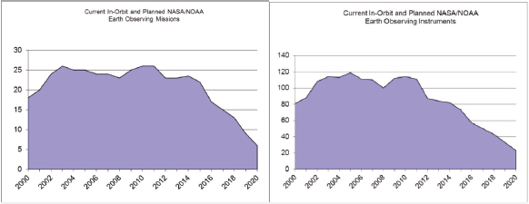
FIGURE 5.1 The number of current and planned Earth observing missions and instruments from NOAA and NASA showing a significant decline by 2020. Figure is courtesy of Stacey Boland, Jet Propulsion Lab (personal communication).
to support weather forecasting, and advanced warning of extreme events—such as hurricanes, storm surges, and floods—would be diminished,” potentially placing lives, property, and critical infrastructure in greater danger.
Another issue with climate data from all sources is that there are significant differences in the metadata, availability, and provision of error and uncertainty estimates for different climate data sets. Although it is difficult to make this globally conformable, climate model validation and intercomparison exercises require a thorough understanding of the available data and their limitations. The climate observing and modeling communities are not optimally integrated, so observations are not always used appropriately.
There needs to be more emphasis on detection and analysis of extreme weather in both the observing and modeling communities, including hydrologic events (flood, drought), severe storms (cyclones, tornadoes), snow and freezing rain events, and persistent extreme temperatures (e.g., heat waves). These are the meteorological events that impact society the most and, thus, are needed for informed decision making, but the observing system and climate models themselves are ill equipped to capture and simulate extreme conditions.
The timely availability of some climate observations may be at risk because of funding shortfalls, data-sharing issues, gaps or unforeseen failures in current and future satellite missions, or transitions between systems (Sullivan, 2011; Zinser, 2011). Parties to the UNFCCC approved the GCOS (2010) recommendations in principle, but funding commitments at a national level are not in place in many cases. Budget cuts are eroding the monitoring network in some GCOS member states.
Finding 5.4: Satellite-based observations are essential for the evaluation and advancement of climate and Earth system models. The U.S. space-based observing system is now in peril, and the timely availability of some climate observations may be at risk because of funding shortfalls, data-sharing issues, gaps or unforeseen failures in current and future satel-
lite missions, or transitions between systems.
ANALYSIS, ASSESSMENTS, AND REPROCESSING
Climate observations come from a diverse system of instruments and are spatially and/or temporally incomplete (Figure 5.2). Meshing them with global climate models to produce a best estimate of the state of the climate at a given point in time can enhance the value of diverse climate observations. The past decade has seen a proliferation of efforts to synthesize these diverse observations into a common framework to produce global synoptic data sets for evaluating the atmospheric, oceanic, and terrestrial components of climate and Earth system models. Such global analyses of climate fields have supported many needs of the research and climate modeling communities. Because they are primarily produced by operational forecasting centers, which are less concerned with long-term data consistency, many changes are made to both the models and the assimilation systems over time. These changes produce spurious “climate changes” in the analysis fields, which obscure the signals of true short-term climate changes or interannual climate variability.
For the atmosphere a solution has been to redo the assimilation of the historical collection of diverse atmospheric observations using a constant state-of-the-art numerical weather prediction model. These “reanalysis” efforts have produced fairly reliable atmospheric climate records that have enabled (i) climatologies to be established, (ii) anomalies to be calculated, (iii) empirical and quantitative diagnostic studies to be conducted, (iv) exploration and improved understanding of climate system processes, and (v) model initialization and validation to be performed (Trenberth, 2010). These products provide the essential foundation for an accurate assessment of current climate, diagnostic studies of features such as weather systems, monsoons, El Niño/Southern Oscillation and other natural climate variations, seasonal prediction, and climate predictability. Importantly, the reanalyses have also provided a vitally needed
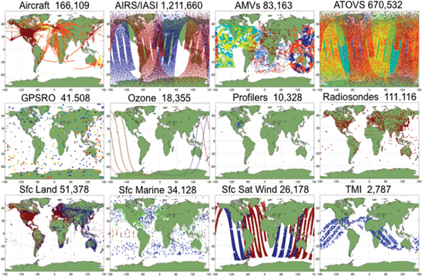
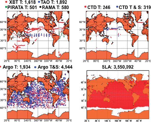
FIGURE 5.2 Climate observations come from a diverse system of instruments and are spatially and/or temporally incomplete. Meshing them with global climate models to produce a best estimate of the state of the climate at a given point in time can enhance the value of diverse climate observations. The top image shows atmospheric observations assimilated into GEOS-5 for a typical 6-hour assimilation window. The bottom image shows the daily distribution of ocean observations throughout 1 month (September 2011). AIRS/IASI, Atmospheric Infrared Sounder/Infrared Atmospheric Sounding Interferometer; AMV, Atmospheric Motion Vector; ATOVS, Advanced TIROS (Television Infrared Observation Satellite) Operational Vertical Sounder; GPSRO, Global Positioning System Radio Occultation; TMI, TRMM (Tropical Rainfall measuring Mission) Microwave Imager; XBT, expendable bathythermograph; TAO, Tropical Atmospheric-Ocean; PIRATA, Prediction and Research Moored Array in the Atlantic; RAMA, Research Moored Array for African-Asian-Australian Monsoon Analysis and Prediction; CTD, conductivity temperature depth; SLA, sea-level anomaly. SOURCE: Courtesy of Michele Rienecker, NASA.
testbed for model improvement on all time scales, especially for seasonal-to-interannual forecasts. Moreover, the basic assimilation and prediction systems are improved as deficiencies are identified and corrected by applying them both in reanalysis and routine weather and climate prediction. Besides improvement in the assimilating model and much better resolution, the data sets that have been analyzed have also evolved. Nonetheless, a serious problem is effects of changes in the observing system that produces spurious changes in the perceived climate. As a result, estimates of trends and low-frequency variability have been unreliable, and this problem is exacerbated by model bias.
Analysis and reanalysis are being extended to support research on other aspects of the climate system too. Data assimilation efforts have grown in the United States, for instance, and now include assimilation of data for weather (e.g., National Centers for Environmental Prediction), seasonal-to-interannual climate variability (e.g., Climate Prediction Center), satellite data (e.g., GMAO MERRA), ocean circulation (e.g., GODAE), and land surface (e.g., GLDAS). Moreover, as assimilation techniques for observations of atmospheric trace constituents (e.g., aerosols, ozone, and carbon dioxide) are refined, reanalysis should eventually provide the means to develop consistent climatologies for the chemical components of the atmosphere, including the carbon cycle, and thus help to quantify key uncertainties in the radiative forcing of climate (IPCC, 2007c). Analysis of ocean data has led to novel data products based on the historical ocean data, so that there are now about 20 different analyses of ocean temperatures and ocean heat content (see Lyman et al., 2010; Palmer et al., 2011). However, there are large discrepancies among them, similar to the many atmospheric analysis and reanalysis products.
Thus, as well as assessments of data sets of individual variables, assessments of reanalyses are also essential, especially with the recent proliferation of atmospheric and ocean reanalysis data sets. Many are created for specific purposes but all differ, often substantially, and the strengths and weaknesses or assumptions are currently neither well understood nor documented. Consequently, assessments are required to evaluate these aspects and help improve the data sets. Moreover, continuous reprocessing is essential. Reprocessing can account for recalibration of satellite data, take advantage of new knowledge and algorithms, and rectify problems and errors that have become evident. As stated by Trenberth et al. (2011), “repeat reprocessing and assessment should be hall marks of a climate observing system.”
Finally, promising developments are occurring in sea-ice and land-surface reanalysis, and coupled data assimilation systems are beginning to be developed. Coupled analysis and reanalysis products are necessary to provide the physically consistent
initial conditions for developing decadal prediction systems, which have the potential to advance adaptation and mitigation planning. Improvements in reanalysis depend on continued support for the underpinning research and required observations, the development of comprehensive Earth system models to expand the scope of reanalysis, and the infrastructure for data handling and processing.
Finding 5.5: Assessments of data sets, of individual variables, and of reanalyses are essential to ensure quality data for the evaluation and development of climate models.
THE WAY FORWARD
Earth is observed more extensively today than at any other time, but many of the observations are not of sufficient quality to monitor long-term climate variability and change. Moreover, some observation systems critical for process-level understanding and model evaluation and improvement are at risk, with declines in both quality and coverage. Gaps also exist in important Earth system observing systems, both in terms of existing systems and new types of observations necessary for improving our capacity to predict future changes in climate especially on regional scales. The U.S. spacebased observing system is now in peril, with an anticipated 75 percent reduction in the number of NOAA and NASA missions over the next decade, and an associated reduction in the number of observing instruments from approximately 90 today to 20 or so by the end of the current decade.
The committee thus strongly supports the findings and recommendations from a number of previous relevant National Research Council reports on the status of the climate observing systems and the importance of reanalysis efforts:
• NRC (2009): “A U.S. climate observing system … should be established to ensure that data needed to address climate change are collected or continued. [This includes] augmenting current satellite and ground observing systems … and support [for] new types of observations, including human dimensions observations that are needed for developing mitigation and adaptation strategies.”
• NRC (2009): “[E]xpand and maintain national observation systems to … fill critical gaps [and support] modeling and process studies.”
• NRC (2010b): “Redouble efforts to develop, deploy, and maintain a comprehensive climate observing system that can support all aspects of understanding and responding to climate change.”
• NRC (2009): “[The United States] should sustain production of atmosphere and ocean reanalyses, further develop and support research on coupled data assimilation techniques … , and improve coordination with similar efforts in other countries.”
In addition, several major recommendations have emerged from this report. First, the diverse suite of climate observations should continue to be scrutinized in order to diagnose the state of the changing climate and understanding the evolving dynamics of the system. Both confrontation of climate model simulations with climate observations and enhanced communication between the modeling and observational communities are critical for assessing model performance, for improving the representation of physical processes in the models, and in some cases for identifying problems with observational data sets. The assimilation of observations into models exploits known relationships among the different climate variables to select or reject the observations and to propagate and/or extrapolate the observations into data gaps in space or time. Data assimilation efforts in the United States and elsewhere, however, operate independently and use separate models. They therefore have not taken full advantage of the entire suite of observations for the Earth system.
A way to rectify this situation would be the establishment of a national Earth system data assimilation effort that simultaneously merges weather observations, satellite radiances or retrievals for precipitation and various trace constituents, ocean measurements, and land and other observations into a full Earth system model, such as one used for climate projections, so as to make full use of the coupled and interactive nature of the Earth system to constrain the data analysis products.
Hand in hand with the Earth system data assimilation effort is the renewed and continued analysis of the available observations, especially in terms of climate variability at regional scales. Regional-scale climate variability is inherently greater than largescale variability, and many aspects of it are poorly simulated in the current generation of global climate models. Furthermore, the causes and signatures of decadal and multidecadal variability need to be extracted from the observations and used to assess climate model simulations on these scales. The committee believes that the nation should continue to sustain its effort in the analysis and comparison of different data sets, including reanalysis products, to improve documentation of their strengths, weaknesses, uncertainties, and utility for different purposes, including model development and evaluation, as well as renew its effort in the analysis of available observations, especially in terms of the nature and causes of climate variability at regional scales. One effort in this direction is the web-based informed guide to selected climate
data sets of relevance to the evaluation of Earth system models, available from NCAR.3 The two main objectives of this work are to (1) evaluate and assess often-used climate data sets and (2) provide “expert-user” guidance and advice on the strengths and limitations of selected observational data sets and their applicability to model evaluations. Another effort in its early stages is “Obs4MIPs,” which is an attempt to provide modeling groups with a limited collection of well-established and documented data sets that have been organized according to the CMIP5 model output requirements.4 More activities along these lines should be supported, because they are vital to the integrity of observational, modeling, and prediction studies of climate variability and change.
Climate data archives are scattered among federal agencies, laboratories, universities, and other repositories (also discussed in Chapter 10). While data catalogs exist, it is not easy for the scientific investigator or the decision maker to access and/or download the multidisciplinary data sets in various formats, subset them, “regularize” them (put them onto common grids, time spacing, units, etc.), and analyze them to advance understanding of the Earth system. The advances of information technology (e.g., OpenDAP3, Goddard Giovanni4) have enabled the remote analysis of subsets of the climate data. These information technology (IT) advances need to be brought to bear on the entire climate data holding, linking all the data repositories (regardless of agency) with a user-friendly nonexpert interface to the data that makes it easy and fast to find variables. This interface would support the ability for interactive standard analyses of the data sets and the download of subsets of the data and the analysis results. The formatting and gridding of the various data sets should not be an issue to the user. Such a national IT infrastructure for Earth system data could facilitate and accelerate advances in data display, visualization, and analysis and could be regarded as a natural philosophical extension of the community software infrastructure proposed in Chapter 10. Ideally, the development of such an infrastructure would be primarily community organized and well coordinated with model intercomparison efforts (which require exactly this kind of product, but then also generate model outputs on the same grid). It would be useful if an entity that has the ability to coordinate the efforts of multiple agencies, laboratories, and universities were to endorse this effort and help achieve an interagency agreement for how to support it. While other organizations could perhaps fill this coordinating role, the U.S. Global Change Research Program (Box 2.1) is the most obvious possibility.
___________________
3http://climatedataguide.ucar.edu (accessed October 11, 2012).
4http://obs4mips.llnl.gov:8080/wiki/ (accessed October 11, 2012).
Recommendation 5.1: The committee reiterates the statements of previous reports that call on the United States to continue and to augment the support for Earth observations and to address the potential for serious gaps in the spacebased observation system. A particular priority should be maintaining fundamental climate-quality observational data sets that have been gathered for 20 years or longer.
Recommendation 5.2: To better synthesize the diversity of climate-relevant observations, the United States should establish a national Earth system data assimilation effort that builds from existing efforts and merges weather observations, satellite radiances or retrievals for precipitation and various trace constituents, ocean measurements, and land and other observations into the same Earth system model simultaneously.
Recommendation 5.3: Building from existing efforts, the United States should develop a national IT infrastructure for Earth system data so as to facilitate and accelerate data display, visualization, and analysis.


