
4
A PROPOSED PLAN
Introduction
In this chapter we propose a plan for the creation of a global network of fiducial stations over the next 5 to 10 years. The viewpoint that fiducial sites should be collocated with sites equipped with a variety of geophysical instruments is adopted implicitly, so that the global network of fiducial sites is equated here, for practical purposes, with the proposed FLINN concept (NASA, 1991).
FLINN is conceived as a network of stations that will provide diverse and precise data to aid in the solution of geophysical and oceanographic problems on both local and global scales. It is anticipated that many of the existing stations can be incorporated into the network; however, it will be expected that the data obtained will meet established and agreed upon standards and specifications. Although collocation of observing systems is a highly desirable feature of the network, stations that operate a limited number of systems will also provide useful information. Hence, many of the core stations considered necessary for the success of FLINN can be considered to exist, although for various scientific and operational reasons some of them will have to be upgraded. Moreover, as a consequence of the number of stations visualized in the network and the amount of data that will be generated, efficient and economic techniques for data transmission, analysis, and distribution need to be established.
The local and global studies to be supported by data from the network range from those that can be addressed by one or two individuals to those that require the attention of large groups of scientists throughout the world. Hence, individual scientists and students should have ample opportunity to contribute to the
advancement of geophysical and oceanographic sciences. The nature of the problems will determine the minimum number and maximum effective distribution of observing stations and the suite of instruments required at each.
Certain key stations may require extensive suites of instruments, whereas at other sites the configuration may not need to be as elaborate. In this regard the cooperation of the host country or group of countries will be essential if the endeavor is to succeed. Each host country will need to maintain and support its existing observing station or stations and establish additional stations where necessary. Some areas conceivably may have a redundant number of stations. In such areas the network might accept all of the data, within the processing capacity of the data centers, or it might elect to accept only those data of the highest quality. In any event, as many of the existing stations as possible should be incorporated into the network.
It will be necessary to provide data links between the observing sites and data and analysis centers, as well as a central service center where the data would be evaluated and prepared for dissemination to scientists throughout the world. Essential functions of the service center will be to provide for quality control and prepare summary reports on data availability. Because of the anticipated quantity of data to be generated and the burden that it would place on a single center, it will probably be necessary to establish regional processing service centers in each region. It will then be necessary to develop data links among these centers, thereby ensuring a truly international and global system. Early in the deployment the data centers should agree on standard formats for archiving and disseminating data and on quality control standards. A comprehensive study to determine the most effective, yet economical, solutions to data problems should be undertaken jointly under the aegis of an international organization. It is essential that the data be available to all scientists for, at most, the costs of data copying and transmission. Essentially, FLINN will require on a global basis the type of data management program already envisioned for the U.S. Global Change Research Program (National Research Council, 1991).
The FLINN program will have to be coordinated on an international scale. The cooperation of the international scientific organizations and the international networks of discipline-oriented observing stations will be essential. The International Union of Geodesy and Geophysics, in conjunction with the various international scientific organizations, might provide this coordinating function.
Strategy
A simple initial strategy for building FLINN is clearly to begin where the very successful programs of the 1980s (in particular the NASA Crustal Dynamics Project) left off. In particular, the existing VLBI and SLR global networks are in place, with well-established standards and well-defined data flow. The IERS, as a result of the MERIT experience, is operating according to a set of agreed upon standards with very extensive international cooperation. By building on existing structures, adding to the existing networks, and adapting the existing infrastructure to the expanded needs associated with the FLINN concept, we can achieve a gradual and flexible implementation and learn along the way what the best strategy should be.
The maps of existing global networks shown in the previous chapter, including in particular the rapidly growing GPS network, show clearly that the ingredients for establishing the GPS core network are nearly all in place. However, a network is much more than a collection of stations. The infrastructure for a smooth and effective flow of raw data, timely processing of these data, and wide dissemination of the data products to the end users is still lacking. As mentioned earlier, the true needs of the end users are still relatively ill defined. Setting up such an infrastructure will require a coordinated national and international effort and the allocation of substantial resources if the full potential of the data is to be realized.
To achieve this goal, the Panel proposes the following strategy:
-
Begin the operation of FLINN immediately, using existing data sources. FLINN is a very ambitious long-term program, and it is not clear that we know how to implement it from our experience to date. It is important to begin to process the data generated by existing stations as the embryonic global network, with emphasis on the processing of data from core stations and production of the relevant data products. We should not expend a large fraction of available resources on deploying new stations and augmenting the network until we have identified effective ways to collect, process, archive, and disseminate the data in a manner that is timely and satisfactory to the user community. This also means that we should explore now the role of international organizations, particularly the IUGG and its member associations. Finally, it means that participating countries should make commitments to allocate the necessary resources to the collective endeavor.
-
Experiment with the collection and processing of large data sets in the framework of time-limited tests or campaigns. This time-honored way to explore multinational, multiagency endeavors has been extremely successful in the past. The MERIT campaign, the GIG'91 experiment, and the proposed EPOCH'92 campaign fall into this category. Each campaign should have explicitly stated goals, whether to test processing capability, appropriateness of data standards, data transmission technology, or administrative structures. The lessons learned from each campaign should result in improved operations for the next one. In addition, such campaigns provide useful epoch measurements for many sites that might be incorporated into the permanent network at some future time. Existing global networks, in particular the CIGNET GPS network, should play a critical role in such campaigns in view of the many participants already involved and the associated infrastructure already in place.
-
Whenever possible, learn from the experience developed in other disciplines. This is particularly true of digital data transmission technology, data archiving techniques and technology, and organizational architecture.
A Network Design Proposal
This section discusses a network design proposal that would satisfy the scientific objectives discussed in Chapter 2. It leads to a proposed network, combining existing resources with long-term wishes, which appears to be realizable, although the task of actually building and operating it will be a major challenge for the next decade.
Core Network
As stated earlier, the GPS core stations should number about 30 or more and should be collocated with equipment using other techniques. Using existing and planned CIGNET and DSN stations, supplemented with a handful of stations that might be collocated with DORIS and PRARE sites, would allow us to meet the GPS core network requirements in the very near future. In fact, enough infrastructure is already in place internationally to begin testing GPS core network operations (orbits, Earth orientation, data flow), provided that the resources are allocated to do it.
Sea-Level Change and Postglacial Rebound
A program of tying high-quality tide gauges to a global reference frame has been initiated within the National Oceanic and Atmospheric Administration. Although relatively few of these ties will be performed with high temporal sampling initially, this program could easily grow to take advantage of new technology and data acquisition, transmission, and processing techniques.
To address all the postglacial rebound issues with a space-geodetic network, we suggest a long-term goal of approximately 100 sites distributed as described below. Of course, many of these sites will also serve other scientific goals, so the number of sites earmarked specifically for postglacial rebound studies would be smaller.
-
Antarctica—to constrain recent current melting and to discriminate among the various types of peripheral bulge behavior predicted by competing models: 10 sites, including 2 sites in the Trans-Antarctic Mountains and 2 sites on the Palmer Peninsula. The behavior of Cape Adare in Victoria Land is important in discriminating among models. Sites on Macquarie Island and/or Campbell Island would be useful, if geologically suitable. Table 5 lists potential Antarctic sites that might be considered for incorporation in the global network.
-
Greenland—to constrain recent current melting and to discriminate among the peripheral bulge behaviors predicted by competing models: at least 6 sites. Table 6 lists possible candidates.
-
North America—to constrain the behavior of the peripheral bulge, particularly in relation to tectonic provinces: 40 sites at ~500-km spacing, paying particular attention to the transition from precambrian shield and platform to fold belts in U.S. (Appalachian) and Canadian Arctic (Innuitian). The Canadian GPS network shown in Figure 15 (Delikaraoglou et al., 1990) represents a system that is currently being deployed and is a major step toward this goal.
-
Fennoscandia—to constrain the behavior of the peripheral bulge, particularly in relation to tectonic provinces: 20 sites at ~400-km spacing, paying particular attention to the transition from precambrian shield and platform to fold belt/margin.
TABLE 5. Potential Antarctic sites.
|
Site Name |
Latitude |
Longitude |
|
Beardmore |
-85.5 |
165. |
|
McMurdo |
-77.9 |
166.7 |
|
Terra Nova |
-75. |
165 |
|
Russkaya |
-75. |
225 |
|
O'Higgins |
-63.3 |
302.1 |
|
UK |
-68. |
292 |
|
Maud |
-71. |
357. |
|
Syowa |
-68. |
40. |
|
Davis |
-68.5 |
78. |
|
D'Urville |
-67. |
140. |
|
Wilkes |
-67. |
111. |
-
Far-field sites—to constrain the rate of tilting of continental margins caused by loading from the oceans: 20 sites—deployed in 5 networks of 4 sites each at ~400-km spacing in geologically stable environments far from regions where ice melted or is melting.
-
Mountain glaciers—at least one global network site at each of the top 10 proposed contributors to global sea-level rise. Densification (up to ~5 sites/region at about 200-km intervals) could be considered part of the global network, or not, on a case-by-case basis. Expected rates of motion are ~0.5 to 5 mm/yr. The regions, taken from the list of Nakiboglu and Lambeck (1991), are shown in Table 7.
TABLE 6. Potential Greenland sites.
|
Site Name |
Latitude |
Longitude |
|
Thule |
77. |
-68. |
|
Narssarssuaq |
61.5 |
-45.5 |
|
Godthab |
64. |
-52. |
|
Christianshab |
68. |
-52. |
|
Upernavik |
73. |
-56. |
|
Scoresbysund |
71. |
-22. |
|
Angmagssalik |
66. |
-38. |
|
Frobisher Bay |
63.5 |
-68. |
|
Hofn |
64. |
-15. |
|
Ny-Alesund |
79. |
16. |
Tectonic Motions and Deformation
A global GPS network will greatly enhance our ability to detect and monitor tectonic signals associated with plate motions and deformation over short times. For convenience in the discussion, we can separate the various types of motions by geological types, although from a geodetic point of view the differences are immaterial.
To monitor rigid relative motions of the major plates, we require a minimum of three global network sites per plate. Taken at face value, this requirement translates into a globally distributed network of approximately 40 sites, which could include the GPS core network discussed above.
On the other hand, to study large-scale nonrigid behavior of the plates, we need an intersite spacing smaller than about one-third of the plate dimensions. This argues for a global coverage with mean intersite spacing of 2,000 km or so, which results in a 100-site network, with fairly uniform distribution. Continuous
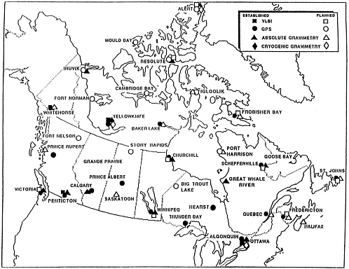
TABLE 7. Contributions of glaciers to eustatic sea-level change.
|
Region |
Characteristic Radius (km) |
Eustatic Contribution (mm/yr) |
|
Kenai Peninsula |
176 |
0.109 |
|
Central Asia |
196 |
0.091 |
|
South Andes |
104 |
0.051 |
|
Cascades, Olympics |
70 |
0.031 |
|
Alaska Range |
72 |
0.025 |
|
Svalbard |
116 |
0.022 |
|
Iceland |
63 |
0.022 |
|
Canadian Arctic |
195 |
0.020 |
|
Novaya Zemlya |
119 |
0.017 |
|
Baffin, Labrador |
121 |
0.012 |
operation is highly desirable, at least at a substantial fraction of the sites, as illustrated by existing transatlantic VLBI baseline data sets. At present, the full range of spatial and temporal scales at which plate deformation may (or may not) occur is not known. A strategy must be developed to avoid difficulties associated with spatial aliasing. For practical purposes it seems that detailed studies (with higher site densities) of a small number of plates of particular geological interest may be warranted. At high latitudes, especially in North America and Europe, this can be done at least in part by taking advantage of sites distributed for postglacial rebound studies.
It must be noted that long baselines cannot be avoided in most oceanic areas. Until such time as GPS transoceanic baselines have been shown to be reliably accurate, it is essential to continue the operation of existing techniques (VLBI/SLR) for long baselines; hence, a collocation requirement exists for this objective.
A 100-site network will achieve a 2,200-km average intersite distance if the distribution of sites is globally uniform. However, it is clear from geology that tectonic deformation is mostly concentrated in relatively narrow (<1,000 km) zones. Figure 16 shows that the regions that are currently (or that have recently been) active tectonically cover approximately 9% of the surface of the Earth. This conclusion is based primarily on geological indicators, as well as heat flow and seismicity. Densifying the global network in these areas to 1,000-km spacing would add 30 to 40 stations. Densifying the network to 500-km spacing would add about 150 stations.
In a number of areas, reconnaissance deployments would be invaluable, and probably a reasonable approach, before selecting permanent global sites. This is certainly the case in regions such as Tibet, where very little is known of the present-day patterns and rates of deformation. It should also be noted that, even if resources may not be available immediately to densify a global network with permanently occupied sites everywhere we should wish to do so, science would still be served by temporary occupations. In fact, the sooner potential sites are occupied for an epoch measurement, the better. These data will be used to make a more cogent selection of permanent sites. In this respect the proposed Epoch '92 campaign should be invaluable.
Possible Network Configuration
By collecting the information discussed above, and starting from the existing networks, the Panel devised a hypothetical network configuration to obtain a rough idea of the appearance of a possible FLINN deployment. It is shown in Figure 16 (see also Figure 1). The GPS core network is derived from existing CIGNET and DSN sites, with a few additions in locations where interested parties have stated their intention to operate a permanent GPS station (e.g., Tahiti, where the French intend to collocate GPS and DORIS sites). The selection of additional sites draws from existing and planned campaigns and from existing regional networks such as the one shown in Figure 15. Sites in Siberia, Tibet, or Africa represent fond wishes and are distributed so as to try to meet the criteria listed above. So are a number of island sites. No effort was made to incorporate ocean bottom sites.
FIGURE 16. Possible configuration of a GPS global network of fiducial stations. Core sites are taken from existing CIGNET, DSN, and other permanent tracking sites. Other sites are taken from existing campaign deployments; no such information was used for such areas as Tibet and Africa. Densification in areas of postglacial rebound and in shaded areas of current tectonic activity follows more or less the guidelines discussed in the text. Collocation with existing stations equipped with other systems (VLBI/SLR/DORIS/PRARE) can be achieved at a large number of sites. The shaded area covers approximately 9% of the total area of the Earth.
Integration with Other Geophysical Networks
Although this report naturally focuses on geodetic networks, other disciplines dealing with solid Earth science are actively deploying global networks of their own. The Panel encourages such groups to consider collocating these observations at fiducial sites along with other geophysical instruments in the expectation that such deployments will encourage a multidisciplinary approach to the study of the Earth. The detailed rationale for the deployment of geophysical networks should be considered both on a disciplinary and a multidisciplinary basis by the appropriate scientific communities. The geodetic community is of course familiar with relative and absolute gravimetric networks mentioned earlier, but coordination with other classes of measurements are also of fundamental interest. Selected global deployments of seismic stations and magnetic observatories are described briefly below.
Several countries are now deploying seismic networks. The two most active deployments are the U.S. IRIS/GSN (Incorporated Research Institutions for Seismology, Global Seismic Network) and the International Deployment of Accelero-meters (IDA), which together will ultimately consist of about 100-high quality stations worldwide. The deployment is under way; the 25 to 30 stations already installed include 6 in the USSR, which will grow to 10 in the near future, and several stations are being installed in the People's Republic of China. In parallel, the French Project GEOSCOPE has already deployed about 20 long-period broadband seismic stations worldwide.
The Group of Scientific Experts (GSE) of the Committee on Disarmament of the United Nations is conducting several Technical Tests (which would be called campaigns in geodesy) involving a global distribution of seismic stations and extensive near-real-time data exchange exercises among 27 participating countries. These tests involve an elaborate network of National Data Centers and three International Data Centers connected by high-bandwidth digital data links. In addition to these global deployments, a variety of modern digital seismic networks are being installed by a variety of countries on either a national or regional scale (e.g., the European ORPHEUS network). These activities are coordinated internationally through the Federation of Digital Broad-Band Seismic Networks. Coordination involves siting plans, data formats, data centers, and mechanisms for data exchange.
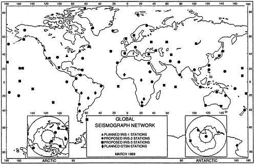
Figure 17 shows the current worldwide distribution of high-quality, broad-band, high-dynamic range, digital seismic stations of the IRIS Global Seismic Network, including the IDA stations. Note the similarity of site distribution and site density between this map and several geodetic network maps shown earlier.
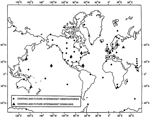
Another global geophysical network of interest will result from the INTERMAGNET program. INTERMAGNET is an international geomagnetic observatory network now managed by the U.S. Geological Survey, the British Geological Survey, the Institut de Physique du Globe de Paris, and the Geological Survey of Canada. The network is expected to grow to about 70 sites in the next few years. It calls for real-time data acquisition from state-of-the-art instruments and therefore presents a challenging communications problem, to be solved initially by using geostationary satellites with multiple downlink points in various regions of the globe. The data collected by such a network will be of immense value to both the solid Earth and space physics scientific communities. Figure 18 shows the planned INTERMAGNET network and also shows that collocation of FLINN and INTERMAGNET sites when appropriate would not visibly compromise the overall distribution of sites.
An important addendum to these brief descriptions is the rapidly growing interest in sea bottom instrumentation. A promising approach, both for seismic and geomagnetic observations, is the scientific use of undersea cables. Several workshops have explored this possibility, with broad participation. Such undersea instrumentation would also be an important element of the Global Ocean Observing System (GOOS), a concept currently being discussed and refined by the oceanographic community. Another major program with a global vocation, which would involve permanent ocean bottom observatories, is the RIDGE program (Ridge Inter-Disciplinary Global Experiments). Finally, to return to geodesy, it must be noted that sea bottom geodetic systems are the object of a vigorous technological development effort and that we should expect to see geophysically interesting results emerge before the middle of the decade (e.g., Spiess, 1990).
These few examples make clear that global geophysical networks are of great interest not only to the IAG but also to other member associations of the IUGG, such as IASPEI, IAGA, and IAPSO. There is of course no reason why the list should stop here, and other types of measurements should be considered as well, such as atmospheric, chemical, meteorological, and environmental. FLINN sites may thus serve as collection facilities for data gathered by local arrays of instruments (e.g., atmospheric and geophysical sensors deployed around a volcano) and provide a common infrastructure for transmitting the composite data stream to one of the global data centers.
The concept of FLINN as a set of globally distributed sites with a multidisciplinary vocation is therefore a logical and desirable generalization of the basic geodetic network concept. FLINN really should provide the necessary ground component of the Mission to Planet Earth, that is, the core of the Permanent Large Array of Terrestrial Observatories (PLATO) originally proposed as an integral component of the mission. Precise space-geodetic control is of course the essential ingredient of FLINN, but a coordinated program in telemetry and data management unquestionably could provide real economic and scientific advantages. Insofar as other disciplinary communities are developing advanced technological solutions to specific aspects of the problem, it seems highly probable that sister disciplines will benefit from a multidisciplinary approach.
Finally, to return to the suggestions made recently by Knickmeyer (1990) and Boucher (1990), in an exchange of correspondence published in the Bulletin Géodésique, the rationale for a “common, global, integrated, fundamental network” includes making various measurements at the same stations, simultaneously. For instance, this network would be coordinated with the International Absolute Gravity Base Station Network (IABGN), under study by the IAG Commission III. Collocation of a sufficient number of sites equipped with a variety of technologies and measurement techniques would be needed to permit the realization of a common coordinate system. A similar theme was developed in Mission to Planet Earth, based on the wide spectrum of spatial and temporal scales one faces when trying to understand the processes of change on the Earth: “This great welter of causative effects with different time scales requires measurements by a variety of means, all requiring completeness, simultaneity, and continuity” (p. 7).
In this respect we must recognize that the scientific objectives of the global network will not be achieved through a single national program, even if such a program intrinsically has a global perspective. Nor will these goals be achieved completely under the umbrella of a single disciplinary international association such as the IAG and its affiliated bodies (e.g., IERS). Instead, the full benefit can be achieved only through coordination of multidisciplinary efforts by several international bodies. This viewpoint was expressed in the report of the Committee on Earth Sciences of the Office of Science and Technology Policy (1989), which lists a variety of such bodies, including the International Union of Geodesy and Geophysics (IUGG) and its seven member associations (IAG, IASPEI, IAVCEI, IAGA, IAMAP, IAHS, and IAPSO), but also:
-
the World Climate Research Program (WCRP);
-
the International Council of Scientific Unions (ICSU);
-
the World Meteorological Organization (WMO);
-
UNESCO and its subsidiary bodies, such as the Intergovernmental Oceanographic Commission (IOC); and
-
the United Nations Environment Program (UNEP).
This list is clearly incomplete. Nevertheless, it serves to illustrate an important point, namely that the path to a more effective network of laboratories used to study the Earth is through international participation. It is also the path for future growth of the global network of fiducial sites, especially as the scientific community focuses its attention on very demanding and difficult environments, such as the bottom of the oceans.


