
2
Water Levels in the Vicinity of the Proposed Repository in the Last 100,000 Years
A brief summary of the geologic history and setting will serve to put into context the panel's field observations and evaluation of the geologic and isotopic evidence used to support the hypothesis of cyclic upwelling of ground water in the Yucca Mountain region. Moreover, models assessing future behavior of the earth systems in the area, which are considered later in this report, require realistic assumptions if the results are to be credible. Therefore, consideration of the geologic setting is key to evaluating such models.
GEOLOGIC SETTING OF YUCCA MOUNTAIN AND ENVIRONS
Yucca Mountain is situated in the southwestern part of the Great Basin physiographic province. The Great Basin is coincident with the northern part of the Basin and Range physiographic province ( Figure 2.1), which is characterized by numerous north-trending mountain ranges and intervening broad, flat valleys, or basins, spaced about 20-30 km apart. For the area of interest for this report, from west to east, Bare Mountain, Crater Flat, Yucca Mountain, and Jackass Flats constitute two such pairs of basins and ranges (Figure 2.2).
Yucca Mountain is located geologically within the Cordilleran mountain belt, an elongate region of active deformation on the western margin of the North American tectonic plate. While this tectonic belt is currently active, it has a long and complex geologic history (Figure 2.3). The modern surface appearance, or physiography, of the Cordilleran belt is mainly the result of geologic activity over approximately the last 10 million years, but the rocks record a geologic history over the last 2 billion years. Crustal deformation that defines the Cordilleran
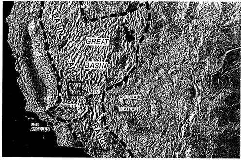
Figure 2.1 Digital shaded relief map of the Cordilleran mountain belt at the latitude of California, showing positions of Yucca Mountain, the Great Basin, and the Basin and Range Province. The northern Great Basin portion of the province drains internally, while the southern portion (south of dashed line) drains into the Gulf of California.
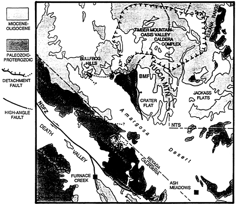
Figure 2.2 Map showing major geologic features of the Yucca Mountain area. Unpatterned areas are alluvium in modern valleys. Major active faults include the Northern Death Valley Fault zone (NDFZ) and Bare Mountain fault (BMF). Detachment faults at Tucki Mountain, in the Funeral-Grapevine Mountains, and Bullfrog Hills, and at Bare Mountain accommodated rapid, largemagnitude crustal extension over the last 15 million years, but are now mainly inactive. The Timber Mountain-Oasis Valley Caldera Complex (outlined by T's) represents the volcanic source region for tuffs that comprise most of Yucca Mountain. Furnace Creek and Ash Meadows are major hydrologic discharge areas in the southern Great Basin. NTS and associated dashed lines refer to the Nevada Test Site boundary.
belt proper dates back approximately 600 million years.
The geologic evolution of the region that includes Yucca Mountain is divisible into three main episodes, each corresponding to the three major geologic eras of the past 600 million years, the Paleozoic (570-
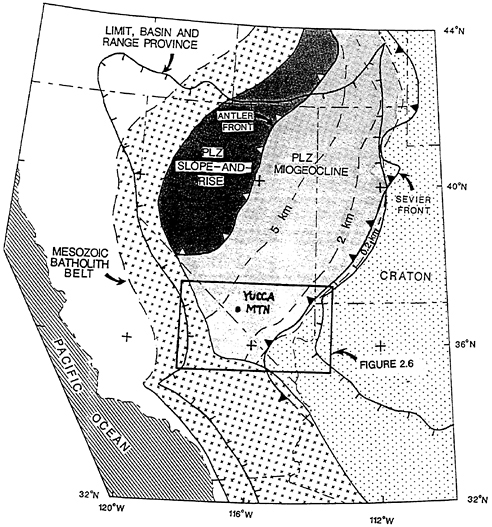
Figure 2.3 Map showing distribution of major tectonic features of the Cordilleran mountain belt. Yucca Mountain lies between an area of thin Paleozoic sediment and minor Mesozoic deformation to the east (craton) and a zone of intense igneous intrusion to the west (Mesozoic batholith belt). The intervening area (Cordilleran (PLZ) miogeocline) is characterized by a thick wedge or prism of Paleozoic sediments deposited mainly in a shallow marine sea (Figure 2.4) that was strongly shortened in Mesozoic time (Figure 2.5). The east limit of strong shortening of the miogeocline (Sevier front) coincides with the edge of thick Paleozoic sediment. Dashed contours show thicknesses of the lower, predominantly sandstone and mudstone, portion of the miogeocline. After Wernicke et al. (1988).
245 million years ago (Ma)), Mesozoic (245-65 Ma), and Cenozoic (65 Ma to the present) eras.
Paleozoic
The Paleozoic was a time of major crustal down-warping along the continental shelf and margin, which formed the miogeocline (Figure 2.4), and of sediment deposition on top of Precambrian (prePaleozoic) crystalline crust (formed ca. 1.7 billion years ago). In southern Nevada, shallow-marine deposits of the miogeocline, originally of sand, clay mud, and calcium carbonate (lime) precipitates, thicken northwestward from about 1 km thick in the Las Vegas area to more than 10 km thick in the Yucca Mountain region (Figure 2.4; Wright et al., 1981). The sand and clay muds of this wedge-shaped sedimentary deposit, called a clastic wedge or prism, are now predominantly quartzite, slate, and other impermeable rocks in its lower part. These rocks now constitute an aquitard, a rock unit that does not readily permit water to pass through. The carbonate, now limestone, that lies above it is an aquifer through which ground water flows easily in fractures and solution channels. Strong Mesozoic and Cenozoic tectonic events deformed these rocks and destroyed the simple wedge-shaped geometry and continuity of the original deposits. The thick Paleozoic limestone that once covered the region as a continuous layer is now a widespread but discontinuous deep regional aquifer through which large volumes of water flow in the southern Great Basin.
Mesozoic
Beginning approximately 250 Ma, the sedimentary prism was horizontally compressed into a major system of folds and west-dipping thrust faults (Figure 2.5). The total contraction of the prism was probably more than 100 km between the Las Vegas and Sierra Nevada regions (Wernicke et al., 1988). Yucca Mountain is situated in the central part of the zone of Mesozoic thrusting and crustal shortening. In the Las Vegas region, major compression persisted until approximately 90 Ma. In the westernmost part of the sedimentary wedge, molten rock of high silica, or granitic, composition was forced up into the crust, crystallizing several granitic bodies into a larger granite mass called the Sierra Nevada batholith (Figure 2.3). The Yucca Mountain area lies mainly to the east of this area of Mesozoic igneous activity. Both the shortening and igneous activity are believed to be related to subduction, or downthrusting, of the ancient Pacific plate beneath western North America (Hamilton, 1969).
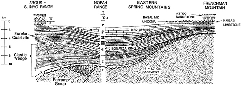
Figure 2.5 Cross-section of southern Great Basin region as it existed following Mesozoic shortening but before Cenozoic extension, showing geologic details of miogeoclinal sediments with respect to major Mesozoic thrust faults. YM shows approximate position of Paleozoic strata in the Yucca Mountain area. After Wernicke et al. (1988).
Cenozoic
A major quiet period lasting 60 million years occurred from late Mesozoic to middle Cenozoic time, from 90-30 Ma. There is no record of sedimentary deposition, or of igneous or tectonic activity during this time. Only relatively minor erosion of the thickened crust occurred. Following this hiatus, a major deformational and igneous event affected the region, and continues to the present. Although subduction of Pacific ocean crust continued into Cenozoic time and was active at the onset of renewed deformation and volcanism following the hiatus in tectonic activity, the deformation beginning about 30 Ma involved extension, or pulling apart the crust, instead of contraction. The molten rock produced by the renewed igneous activity emerged onto the earth's surface mainly as volcanoes and lava flows. This type of activity was in contrast to the deep granitic bodies that intruded the crust during the Mesozoic. Millions of years after they formed in the crust, uplift and erosion of the rocks that covered them exposed the massive granite bodies at the earth's surface, which are now called the Sierra Nevada Mountains.
Extension
Extension of the crust occurred mainly along west-dipping normal faults (roughly parallel to the older thrust faults) and associated northeast-and northwest-trending strike-slip faults (Figure 2.6). Two major north-trending belts of extension and normal faulting developed, one largely in the Las Vegas/Lake Mead area to the east (Lake Mead extensional fault system), and another within the shortened sedimentary wedge (Death Valley extensional fault system), which includes the Yucca Mountain area. The entire Basin and Range at the latitude of Las Vegas has extended about 200-300 km across the province in two phases (Wernicke et al., 1988). Although evidence of extensional activity and related development of basins and ranges dates back to approximately 30 Ma in the southern Great Basin (Axen et al., 1991), the majority of extensional strain and volcanism in the Yucca Mountain area appears to have occurred in the last 10-20 million years (Scott, 1990; Wernicke et al., 1988). Extension appears to have been most rapid from 15-5 Ma, when the rate is thought to have been 10-30 mm per year. Extension has resulted in local severe thinning of the sedimentary crust, completely removing it in some areas. As a result the thickness of the Paleozoic limestone beneath Yucca Mountain is uncertain, but was likely very much thinned or pulled apart by extension in mid-Miocene time (15-10 Ma). Extension in the southern
Figure 2.6 Map showing major Cenozoic strike-slip and normal faults in the Basin and Range province at the latitude of Yucca Mountain. OVF, Owens Valley fault; NFZ, SDF, northern and southern branches of the Death Valley fault zone; BMF, Bare Mountain fault zone; LVVSZ, Las Vegas Valley shear zone; LMFS, Lake Mead fault system. Two strongly extended areas of the Basin and Range, the Lake Mead and Las Vegas normal fault systems, lie east and west respectively of a medial unextended block that includes the Spring Mountains. Active strong extension is restricted to region west of Death Valley. After Wernicke et al. (1989).
Great Basin region (Figure 2.1) slowed down after 5 Ma to its present rate of approximately 5-10 mm per year.
The waning of major extensional activity migrated westward across the Death Valley region, beginning 10-15 Ma in the eastern part of the Basin and Range, but extension persists to the present day in the western part (Wright et al., 1984; Hamilton, 1988).
Volcanic Activity
Between 14 and 11.3 Ma, the Yucca Mountain area experienced large-volume, explosive volcanism resulting in extensive fallout of volcanic ash. The accumulation of massive layers of this ash resulted in the formation of rocks known as ash-flow tuffs (Frizzel and Shulters, 1990). Yucca Mountain itself is composed mainly of such tuffs, including the Crater Flat, Paintbrush, and Timber Mountain tuffs. In some places where there were thick accumulations of ash composed mainly of volcanic glass shards (fragments), the shards became welded together under the combined action of the heat retained by the particles, the weight of overlying material, and hot gases. Welded zones thus formed within ash-flow tuffs are very dense and, for the most part, impermeable, but they are also brittle and have responded to stresses by forming many fractures through which water may flow. The proposed repository at Yucca Mountain is designed to be excavated in a welded tuff, the Topopah Spring Member of the Paintbrush Tuff (Figure 2.7). The sources of the tuffs are volcanic centers of silica-rich rocks distributed throughout the region immediately to the north of Yucca Mountain (Figure 2.2). Nearby volcanic eruptions associated with these centers in the later stages of silicic activity extruded low silica/high iron lavas which cooled to form basaltic rocks (e.g., on Skull Mountain south of Jackass Flats).
It is important to note here that the high silica volcanic activity ended about 11.3 Ma, and that the low silica basalt volcanism occurred in two phases, about 10 Ma and between 3.7 and 0.13 Ma. Further discussion of the volcanic history of the Yucca Mountain vicinity appears in Chapter 4 of this report.
The age relationship between major extension and volcanism in the region is complex. While broadly synchronous, major extension largely preceded volcanic activity in some parts of the southern Great Basin and followed it in others. At Yucca Mountain, an episode of rapid extension likely occurred prior to the accumulation of the Paintbrush and Timber Mountain Tuffs, extending the previously shortened Paleozoic sedimentary wedge tenfold or more. Subsequently, the tuffs were mildly extended, resulting in a series of gently tilted domino-like
fault blocks (Scott, 1990). Although movement on these faults appears to have been mainly synchronous with silicic volcanism in the Miocene, at 14-11.5 Ma, a number of the faults offset Quaternary deposits (Swadley et al., 1984), indicating that extension continued to the more recent past.
Active Tectonics
While rapid extension and major silicic volcanism have ceased in the Yucca Mountain area, both continue to the west in the Death Valley/Owens Valley region, e.g., the Death Valley and Owens Valley faults, and the Long Valley Caldera. At Yucca Mountain and vicinity, Pliocene and Quaternary (5 Ma to the present) basaltic volcanic activity and slow extension appear t o have continued. See Chapter 5 of this report for a detailed discussion of, and constraints on, active deformation in the Yucca Mountain region.
EPISODIC GROUND-WATER DISCHARGE THESIS
The thesis that ground water was periodically forced up from depths of hundreds of meters and discharged repeatedly on the surface of the earth near Yucca Mountain has great importance for the long-term capability of the proposed Yucca Mountain repository to isolate radioactive waste. The present level of the water table ranges from about 200-400 m below the design level of the floor of the proposed repository. The repository is designed to be about 400 m below the surface (DOE, 1988).
The chief evidence cited to support the upwelling ground-water thesis (Szymanski, 1989; and pers. comm. 1991) is the presence of surficial calcite deposits and calcite-cemented breccias related to faults in the vicinity. The calcite deposits occur (1) within the soil in layers parallel with the surface, (2) as stream-bed deposits, (3) as cement around angular fragments of tuff (breccia), or (4) as “veins” (fracture-fillings) in steep to vertical fractures in the ash-flow tuffs that make up most of the bedrock of the Yucca Mountain area. Soil, vein, and breccia deposits are exposed in several trenches excavated across faults to assess the extent of Quaternary fault movement, and in natural exposures in ridges and stream valleys near Yucca Mountain. The thesis proposes that calcium carbonate (CaCO 3) brought up by deep ground water was deposited in the fractures, on the ground surface, or between rock fragments broken by the force of the pressurized upflowing water to become calcite-cemented breccias.
As suggested in the introduction to this report, most investigators who have conducted detailed studies of the geology, mineralogy, and
geochemistry of the fault-filling materials have concluded that these deposits resulted from surficial and pedogenic (soil-forming) processes, whereby evapotranspiration of rainwater that has infiltrated the soil and bedrock leaves behind an accumulation of calcium carbonate and silica that eventually fills the fractures (Swadley and Hoover, 1983; Taylor and Huckins, 1986; Vaniman et al., 1988; Quade and Cerling, 1990; Stuckless, 1991). Similar processes are evoked for the origin of surface-parallel and stream deposits.
The panel took into consideration the previous work done and the differing views. However, it depended heavily upon its own observations and evaluation of the evidence available to it, and its own and others ' modeling, for its deliberations and findings relative to the origin of the carbonate deposits and the likelihood of ground water upwelling hundreds of meters.
The evidence bearing on whether or not the potentiometric (water table) level in the Yucca Mountain region has exceeded the level of the proposed repository at any time during the last 100 ka can be placed into six general categories: (1) soil development and geomorphological character of the region; (2) hydrologic evidence obtained from long-lived and extinct spring systems in the region; (3) morphologic/textural evidence exhibited by chemical precipitates; (4) stratigraphic/textural/mineralogic evidence exhibited by carbonate-cemented breccias; (5) geochemical/mineralogic considerations bearing on the likely conditions of deposition of chemical precipitates; and (6) isotopic evidence for the origin of waters and solutes. In addition, the relative ages of the carbonates with respect to the associated geologic or geomorphic features can provide some measure of the reasonableness of an upwelling ground water origin for these deposits.
In considering the evidence cited in support of upwelling ground water, the panel's approach was to ask a series of questions related to the above categories. Thus, in relation to the field observations, the panel asked what features or characteristics would be expected if the carbonates were derived from soil-forming processes, and what would be expected if the water were of deep crustal origin thermally and/or tectonically driven to the surface. The first question is addressed in the following section. The second is addressed subsequently in the five other categories of evidence.
SOIL DEVELOPMENT AND GEOMORPHOLOGICAL CHARACTER OF THE REGION
Characteristics of soils in various climatic regions are well known, particularly to soil scientists studying processes of soil development. The soils in semi-arid to arid regions, like that of the southern Great
Basin, have common characteristics throughout the world that do not depend on a subsurface source of water; many of these regions are far from any tectonic or volcanic activity. The question is, are the soil characteristics and processes of soil carbonate development in the Yucca Mountain area similar to those of other regions with similar climate throughout the world, or is there something unique about the area in question?
Secondary carbonate can accumulate in the soil profile by a variety of pedogenic processes, as described by Machette (1985). These processes include in situ weathering of calcium carbonate from the parent materials and leaching of calcium carbonate from calcareous materials emplaced on the ground surface as airborne dust. The leached calcium carbonate is transferred in solution to a position lower in the soil profile where it precipitates and accumulates at a depth controlled by several interrelated soil properties and the degree of evapotranspiration (McFadden and Tinsley, 1985). Soils enriched in calcium carbonate are associated with semi-arid to arid climates and are present throughout the southwestern United State (U.S. Soil Conservation Service, 1990; Machette, 1985). In wetter environments the carbonates remain in solution and are carried out of the soil environment.
The secondary carbonate concentrated by pedogenic processes below the soil surface horizon (A horizon) accumulates in the lower horizons (Bk and K horizons) (see Box 2.1). The A horizons are generally vesicular (i.e., they contain macroscopic spherical voids) in dry climates when associated with the accumulation of airborne dust on the surface (McFadden et al., 1986, 1987). The percentage of carbonate increases with depth in the soil and then decreases with depth still lower in the soil. The thickness of the subsurface soil horizons (e.g., B and K horizons) and the strength of individual soil properties used to describe the soil increases with increasing age of the soil. Beneath progressively older surfaces the carbonates are progressively better developed. A morphological sequence involving progressive stages of development has been established by workers in the southwestern U.S. to describe the systematic changes in the pedogenic carbonates (Gile et al., 1966; Backman and Machette, 1977; Machette, 1985). A similar sequence has also been developed to describe the progressive morphological changes in the pedogenic silica common to the Yucca Mountain area (Taylor, 1986).
The morphological stages in the case of carbonate buildup change from a few filaments and (or) thin discontinuous pebble coatings in stage I to more continuous coatings and soft nodules in stage II. Stages III and higher are represented by massive carbonate accumulations
|
BOX 2.1 Soil Horizon Nomenclature A horizon 1 This is a soil horizon that has an accumulation of humified organic matter mixed with a mineral fraction, the mineral fraction being dominant. The horizon typically occurs at the ground surface. This horizon is considered vesicular when it is characterized by a high volume of spherical pores, giving a sponge-like appearance. The origin of these vesicles in desert environments is often associated with eolian (wind-blown) material being added to the surface (McFadden et al., 1987). B horizon This term refers to those horizons which have materials illuviated (transported) into them (from the weathering of minerals higher in the soil sequence (profile) or from materials first deposited as airborne dust) or residual concentrations of materials left by leaching. B horizons, which typically occur beneath the A horizon, show little evidence of the original parent material. Subdivisions of the B horizon are many, based upon the materials concentrated within the horizon. In arid environments these include: Bk horizon: the “k” denoting the illuvial accumulation of carbonates. Bt horizon: the “t” denoting a noticeable accumulation of silicate clay that either formed in place or was illuviated into the B horizon. It therefore has more clay than the overlying horizon or parent material. Bq horizon: the “q” denoting the accumulation of secondary silica. Bw horizon: the “w” denoting an increase in color (generally redder) or structure without noticeable accumulation of silicate clay. K horizon This is a subsurface horizon so impregnated with carbonate that its morphology is determined by the carbonate (Gile et al., 1965). Authigenic carbonate coats or engulfs nearly all primary grains in a continuous medium. The uppermost part of a strongly developed horizon is laminated, brecciated, and (or) pisolitic (Machette, 1986). The cemented horizon corresponds to some caliches and calcretes.
|
and notable cementation. Laminae, pisolites, and brecciation are apparent in the more advanced stages of development.
In the case of silica stages, stage I is represented by thin scale-like coatings on the bottoms of gravel clasts, while stage II has developed 2-4 mm pendants on the bottoms of the clasts. Stages III and IV have silica cementation, with laminae occurring in stage IV. The progression of morphological stages mirror the buildup in the percentage of carbonate and (or) silica in a sequence of progressively older soils. When used in association with increases in other soil properties (clay percent, reddening, thickness of the B horizons, etc.) and an awareness of soil-forming factors, these stages become strong indicators of soil age. When multiple soil properties reflect greater soil ages on geomorphically older surfaces, it is also strong evidence for a pedogenic origin of all properties, including the carbonates. (For excellent regional studies demonstrating these principles see Gile et al. (1966), Sowers (1985), and Machette (1985)). The progressive changes of associated soil horizons would not result from upwelling water.
All of the above features of arid climate pedogenesis are present in the Yucca Mountain area. A direct correlation between the relative age of the geomorphic surface and degree of Bk or K horizon development was noted in several localities by the panel. For example, the oldest geomorphic surface observed, in Fortymile Wash (probably 1-2 Ma; Taylor (1986), M. Reheis, pers. comm., 1990) exposed a clay-rich B horizon with a K horizon 1 m thick and a silica-cemented subhorizon. Progressively younger geomorphic surfaces in Fortymile Wash have progressively less pronounced textural and calcic horizons (Taylor, 1986; M. Reheis, pers. comm., 1990). Intermediate-aged surfaces, such as the slopes of Yucca Mountain and Busted Butte, a steep-sided isolated remnant of Tiva Canyon and Topopah Spring tuffs, have calcrete horizons from a few centimeters to fractions of a meter in thickness. The youngest surfaces identified, in the localized contemporary drainages throughout the region, have weakly developed soils, characterized by thin vesicular A horizons and incipient, discontinuous thin laminae of calcrete. A notable example was observed by the panel members on the flanks of the youngest volcano in the area, Lathrop Wells cone, where the cinders are coated on their bottom side with a thin carbonate film derived from windblown silt and carbonate accumulating on the slopes of the volcano. These correlations argue for a pedogenic origin for the calcretes, because thickness of carbonate deposits from upwelling waters would have no consistent relationship to stage of soil development or age of the geomorphic surface.
An important consideration in establishing the validity of the correlation of surface age and carbonate development requires that the area not have been reset to calcrete-free conditions during any prior glacial climatic episode when rainfall was greater in the region. Paleoclimate studies of the region, discussed in some detail in Chapter 3 of this report, demonstrate that regional climatic conditions over the last 100 ka were not wet enough to reset the starting time of pedogenic carbonates formed in the oldest surfaces. The older geomorphic surfaces and related soils have been dated or assigned ages of 100 ka to 1 Ma on the basis of morphology of alluvial fans and terraces along drainage systems, the stage of development of the soils, the degree of development of desert pavement (interlocking surface stones) and rock varnish (dark coating on exposed rock surfaces), and the characteristics of buried soils. For a review of surface age control, see Taylor (1986). Thus, climatic and surface water conditions have been conducive to soil calcrete development for at least several hundred thousand years.
Other well-known pedogenic features of the surface-parallel carbonates commonly observed throughout the area around Yucca Mountain are laminar (finely layered) structure of the carbonate deposits, root casts developed by former plants that filtered the soil water, leaving behind carbonate coatings on the roots, and carbonate nodules, which are spherical or orbicular concentrations formed by the deposition of carbonate in the soil around some “seed” or “kernel” that stimulated deposition.
Because pedogenic carbonate accumulation processes and rates are dependent upon the amount of calcium ion, Ca2+, and calcium carbonate (CaCO3) available to the soil, it is reasonable to ask if these are present in the area. The presence of the Paleozoic limestone at depth, comprising the regional aquifer, is well established for much of the area (Dettinger, 1989) and could provide dissolved carbonate in upwelling ground water. In the Yucca Mountain region, however, considerable surface exposure of this limestone is present in the Spring Mountains, and even nearer Yucca Mountain, in Bare Mountain, on the west side of Crater Flat. Dissolution and reprecipitation of the carbonate from the limestone could occur in surface and near-surface waters. The carbonate coatings of cinders on Lathrop Wells cone, the carbonate-bearing vesicular A horizons on the volcanic ridgetops, and dust-collecting studies being carried out by scientists involved in the Yucca Mountain site characterization project (Marith Reheis, pers. comm.), attest to the presence of calcium carbonate as airborne particles, or as Ca 2+ dissolved in rainwater. In addition, the stream-bottom carbonate deposits are laminated calcretes which suggest runoff
from surface exposures of carbonates, and reprecipitation as gullybed cementation as described by Lattman (1973) and by Bachman and Machette (1977).
Although proponents of the thesis of rising ground water assume a single source, that of upwelling deep ground water, for the secondary carbonates in the Quaternary of the Yucca Mountain region, multiple origins and ages for the carbonates are discernible. Some examples of the different sources and ages of carbonates of the region are: (1) at Travertine Point along the east flank of Death Valley, 50 km southwest of Yucca Mountain, characteristics of carbonate occurrences to be discussed later in this chapter are typical of shallow veins and spring deposits that form where CO2-charged waters flow to the earth's surface from depths in excess of 1-2 km where the water attains high partial pressure of CO2 greatly in excess of atmospheric pressure; (2) at a site about 14 km southwest of Yucca Mountain, known as Site 199, a spring mound provides evidence of a ground-water source that may still be active; (3) near the southern end of Yucca Mountain, carbonate-filled fractures in the Tertiary tuffs are truncated by the overlying Tiva Canyon tuff, verifying that the carbonates formed before the Tiva Canyon tuff was deposited, most likely during the cooling of the volcanic ash that became the tuffs about 13 Ma; and (4) in locations near Busted Butte, in a faulted valley at the southern end of Yucca Mountain informally known as Harper Valley, and on Old Stagecoach Road, stream-bottom carbonates are restricted to the modern topographic drainages and therefore indicate localized cementation from evapotranspiration of calcium-enriched surface waters (see, e.g., Machette, 1985).
One significant example will serve to demonstrate the contradictions that arise from the assumption of a single source for all secondary carbonate deposits in the area. The faulted tuff remnant, Busted Butte, contains numerous calcite deposits that have been cited as evidence for upwelling water. The Butte is flanked by gently sloping sand-ramp aprons. The sand ramps are built of windblown sand deposited on layers of cobbles swept down from the steep upper slopes by gravity and surface water runoff. Some sand ramps began depositing shortly before 740 ka, as determined by identification near the base of those ramps of an ash bed from a very well-dated and widespread volcanic ash, called the Bishop ash. Calcite deposits are exposed in the walls of gullies that cut into the sand ramps. The deposits are calcite-cemented cobbles and sand that spread laterally and parallel the present-day gently inclined ground surface. Some of the carbonate deposits are 0.5-1.0 m thick and, downslope, bend and merge into steep calcite deposits that fill vertical fractures in the
underlying sand ramps. Similar slope-parallel deposits downslope of the vertical fracture-fillings are thinner than those above the fracture, and also appear to merge with the vertical carbonate deposits. These vertical deposits merging both upslope and downslope into upwelling along faults precipitated the calcium carbonate in the fault slope-parallel carbonates were cited as evidence that ground water and spread out on the surface to form the slope-parallel deposits. Such interpretation of the carbonate occurrences leads to two important inconsistencies: (1) the thick surface-parallel deposits upslope from the fault require that water flow uphill continuously and in greater quantity than downslope to produce the observed deposit; and (2) both gently sloping and vertical calcite deposits contain delicately calcified roots of plants wrapped around cobbles of volcanic rocks. The latter observation combined with an integrated soil profile encompassing the Bk/K horizons constitutes evidence that the surface-parallel calcite cements formed in the root zone of soil horizons, not on the ground surface.
In response to the observation by panel members of increasing carbonate thickness upslope of the fracture, proponents of the upwelling ground water origin for the carbonate deposits suggested that a fault at higher elevation than that observed was probably the source of the upwelling water. Panel members examined heads of gullies for carbonate-filled fractures or faults at higher elevations on the Butte that could have acted as upwelling ground water sources for the thicker upslope, surface-parallel calcite cements, but none were found.
To the panel's knowledge, the roots, which calcified progressively through time with the soil carbonate buildup, have not been assigned to any plant species. Although the possibility exists that they could have been wet-ground plants, it appears unlikely, given the evidence discussed above.
The foregoing observations, which form the basis of the panel's conclusions with regard to the first category of evidence, soils and geomorphology, can be summarized as follows: consistent well-established arid soil characteristics of the soil (A/Bk/K horizons) and vein carbonate, field relations indicating a correlation between age of the geomorphic surfaces and the degree of soil carbonate development, strong evidence for the presence of airborne carbonate, and the physical inconsistencies in attributing an upwelling ground water source for the slope-parallel and vein carbonate. The panel concludes from these findings that (1) the soil and vein carbonates formed from normal arid climate soil-forming processes; and (2) no field evidence observed supports the thesis of cyclical or
periodic outpouring of ground water onto the surface 1 . Although both currently active springs and ancient spring deposits occur in the area, as will be shown later in this chapter, their characteristics and ages suggest differing origins, none of which require a deep ground-water source.
HYDROLOGIC EVIDENCE FROM SPRINGS
Springs are locations where ground water emerges spontaneously onto the surface as the result of some unique circumstance of the geology of the site. There are many different circumstances that can result in a spring, and the cause of any one spring may not be immediately apparent. Warm water springs may result from deep-seated ground water rising rapidly to the surface; hot water springs often arise from near a deep volcanic source that heated the water; cold water springs suggest shallow ground water. But there may be other explanations for the variations in water temperature.
Although cold, warm, and hot springs each have unique features, they have some common attributes. Among these are chemically rich water and the buildup of a mound and/or stratiform tufas on the surface. Cold spring mounds form from the accumulation of airborne silt. The more relevant process that is addressed here is the formation of warm or hot spring mounds. The mounds of these springs derive from the precipitates left by evaporation or loss of CO2 from the spring water, especially in dry climates or where chemical conditions are favorable, and from the buildup of wind-blown dust trapped by dense vegetation growing on moist soils. Often the mound is composed of a porous calcium carbonate (travertine or tufa) where water flows to the surface from a relatively shallow source region (<100°-120°C). However, mounds of other chemical precipitates are known as well, such as silica (SiO2) where water flows to the surface from a relatively hot source region (>170°C), and gypsum (CaSO4•2H2O).
Devils Hole
Reconnaissance studies of variations in the level of the water table throughout the Quaternary in the Ash Meadows area, 40 km south-southeast (SSE) of Yucca Mountain (see Figure 3.1 in Chapter 3 of this report), found no indications of large rises in the water table
|
1 |
In this report, the panel's conclusions and recommendations are in bold type. |
(Winograd and Szabo, 1988), even though the entire region is tectonically active. Winograd and Szabo (1988) synthesized regional hydrologic, tectonic, and paleoclimatologic information, including ages of vein calcite, travertine, and other features indicative of paleo-ground-water discharge. They concluded that a progressive and absolute lowering of the potentiometric surface (water table) is likely to have occurred throughout the south central Great Basin during the Quaternary.
At Ash Meadows, in an underground cavern called Devils Hole, the present water table is 16 m below the surface. Uranium-series dating of calcite deposited on the walls of this cavern by ground water shows that the elevation of the water table has not been greater than 9 m above the present water table in the last 45 ka (Winograd and Szabo, 1991). Other evidence suggests that the water table has been below the land surface at Devils Hole for hundreds of thousands of years (Winograd and Szabo, 1991). This conclusion is supported by the absence of a tufa mound or a stratiform (layered) tufa at Devils Hole.
Inasmuch as the Devils Hole area is within the same tectonic province as Yucca Mountain, the Basin and Range, and, moreover, has a rate of extension two to three times that of the Yucca Mountain area, it is reasonable to expect that if earthquakes have caused the ground water to rise hundreds of meters at Yucca Mountain, similar events would have occurred in the Devils Hole/Ash Meadows area. Yet at Devils Hole where the water table is only 16 m below the surface, and where there have no doubt been earthquakes over the hundreds of thousands of years of the cavern's existence, no evidence of episodic large and protracted upwellings of ground waters is present.
There are, indeed, small, short-lived, surging changes in the water level in Devils Hole in response to earthquakes. Instruments installed in Devils Hole continuously record water levels, but sudden upward surges greater than 0.15 m cannot be measured with this equipment because the cable extending from a float to the recorder is knocked off its pulley. However, approximate limits to the amount of upward surge of water can be determined by observing the locations of algal mat material that rises with the water and is left stranded on the rock wall when the wave recedes. A few days after the 1989 magnitude 7.1 Loma Prieto earthquake, centered about 500 km to the northwest of Devils Hole, observers in Devils Hole concluded that the upward surge of water in response to that earthquake reached a height of at least 0.6 m above the normal water level, based on the elevation of algal mat material above the water table, stuck to the
rock and to the staff gage. At the time of the observations the staff gage indicated that the pool surface was back to its pre-earthquake level. Apparently there had been a very short-lived fluctuation, or upward and downward surge, in the water table with a total amplitude of at least 1.2 m (A. C. Riggs, pers. comm., 1992).
Wahmonie Spring
About 20 km east of Yucca Mountain a locale called Wahmonie Spring has been cited as evidence of recent ground-water upwelling. The Wahmonie site is a barren outcrop of white to buff gypsum-bearing (CaSO4•2H2O) sediments interpreted by proponents of the upwelling ground water thesis as a young spring deposit 1000 years old or younger. The sulfate-rich composition of this deposit was ascribed to deep seated ground water rising along a nearby, unnamed fault. The lack of plants growing on the gypsiferous soils of the Wahmonie outcrop was cited as evidence of youthful age of this deposit.
The Age of the Wahmonie Site
In the panel's view, absence of vegetation on this outcrop is not an indication of the relative youth of the deposit. It is more likely a function of soil conditions. Although there is little in the published literature on the plant community composition of gypsiferous soils, it is widely known that gypsum substrates support few plant species and these possess adaptations to gypsum soils. The absence of plants on the Wahmonie outcrop most likely results from the lack of plant species adapted to gypsiferous soils in this part of the southern Great Basin (see, e.g., Beatley, 1976), rather than from youth of the deposit and insufficient time for plant communities to develop since its desiccation.
A more direct line of evidence relating to the age of spring deposits is material evidence of early human activity. In this desert region springs have been the locus of intense prehistoric and historic human activity. The persistent presence of Native American populations at such localities is easily noted by extensive scatters of chipped rock materials found at many presently active and extinct spring mounds in the Las Vegas Valley and the Yucca Mountain region. At the Wahmonie locality, however, no prehistoric artifacts have been found at the outcrop. Moreover, no historic Euro-American artifacts, such as tin cans or bottle glass, that would, as a matter of course, be present if there has been effluent water source present over the last century or so.
Two lines of evidence suggest that the Wahmonie deposit is of great age:
-
The apparent total absence of elemental carbon residues of plant matter in the deposit. Late Wisconsin- and Early Holocene-age spring sediments in the Las Vegas Valley typically display two types of elemental carbon, disseminated gray to dark-gray lenses resulting from organic mats incorporated into the sediments, and charcoal resulting from the deposition of carbonized wood from the time that springs were active (see, e.g., Haynes, 1967). Neither of these is evident in the profiles of the Wahmonie deposit.
-
Field relations suggesting that the gypsum-bearing spring deposit, on the down-dropped side of a fault, is being exhumed by headward erosion of an adjacent wash. The gypsum deposit, exposed as a relatively narrow band about 10-20 m in length and less than 3 m wide, appears to underlie a fan surface with a soil profile that panel members estimate required 10-100 ka of stability to develop. Erosion parallel with the fault and headward erosion on the fan surface have apparently removed the younger fan sediments overlying the gypsum deposit.
The weight of evidence appears to indicate that the Wahmonie outcrop is probably much greater than 11 ka in age (the widely accepted minimum age for the introduction of humans into North America). The apparent burial of the deposit and subsequent exhumation from beneath a surface judged by panel observers to be possibly as old as 100 ka strongly supports this conclusion.
Moreover, the significance of this site as evidence for deep-seated ground-water upwelling was based in part on the gypsiferous composition of the deposit on the assumption that the sulfur must have had a deep source. However, the panel noted that in the hills above this locale were abandoned mines and test pits into sulfide mineral deposits, the origin of which is very likely related to the early volcanic activity of the region more than 1 Ma. Thus, the likelihood that the sulfate-bearing surface deposit resulting from surface or near-surface runoff of meteoric (rain) water flowing through the sulfide mineral deposits is at least as credible as upwelling deep ground water, or more so, as the following discussion of Cane Spring will suggest.
Cane Spring
Cane Spring, located near the northeast end of Skull Mountain, about 20 km southeast of Yucca Mountain, was cited as a very recent upwelling, having broken through to the surface and wetted that
area within the last century or two. Cane Spring is an active spring site; a large mound (ca. 40 m by 20 m) of gray to dark-gray organicrich soils supports, among other species, cottonwood (Populus fremontii), willow (Salix goodingii), and cattails (Typha domingensis) rooted in perennially wet soils around an active discharge orifice with running water in evidence. The discharge of Cane Spring, however, is miniscule, on the order of 0.04±0.015 liters/sec (Lyles et al., 1990). Similar springs are symmetrically located on the southeast flank of the mountain. These springs occur near the break in slope between the steeper fractured rocky mountain and the gentler sloping fan.
The extensive buildup of organic-rich silts on this spring mound, the massive size of the trees at this locality, and the extensive development of vegetation mats attest to a long history for Cane Spring. Moreover, the occurrence around the spring of abundant prehistoric artifacts such as secondary and tertiary reduction flakes from toolmaking, ground stone, and fire-cracked rocks strongly suggests that this locality has been the focus of prehistoric activities for millennia.
The source of water for this spring is uncertain. Although it lies close to a north-south fault, four factors call into question a deepseated origin for the spring. The first factor relates to the location of several active springs like Cane Spring that occur in the area, north of Yucca Mountain. Nearly all of those currently known are located, as Cane Spring and its southeastern counterpart on Skull Mountain are, at or near the base of the rocky slopes. Secondly, the spring waters flow out at ambient temperatures, or those of the surrounding environment, not warm or hot as would be expected of water from a deep-seated origin. The third factor is the observation made by Yucca Mountain Project field investigators that Cane Spring increases in activity and flow immediately after a rainfall. The fourth factor, as discussed later in this chapter, is the oxygen and hydrogen isotope analysis of Cane Spring waters, which shows them to be similar in isotopic content to local rainwater, although enriched in both the hydrogen isotope deuterium (D) and 18O in relation to ground water by evaporation (see Figure 2.8). Taken together, these factors support the conclusion that the active spring source is the infiltration of meteoric water in the adjacent mountain mass and its subsequent emergence through rock fractures at the base.
MORPHOLOGIC/TEXTURAL EVIDENCE EXHIBITED BY CHEMICAL PRECIPITATES
Where warm waters containing carbon dioxide (CO2) gas flow upward from deep-seated reservoirs a few kilometers down in the crust and discharge at the earth's surface, steep-sided mounds, ridges, and
terraces of travertine with flat to rounded tops typically form. Well-known examples of this occur at Mammoth in Yellowstone National Park (Bargar, 1978), Big Horn hot springs at Thermopolis, Wyoming (Burk, 1952), and near Bridgeport, California (Waring, 1915). The travertine in these deposits is composed of thin layers, or bands, of relatively coarse-grained (2–3 mm) calcite. Larger mineral grains are typical of higher temperature deposits.
If, as has been suggested, deep ground water has risen repeatedly and has discharged onto the surface in the Yucca Mountain area, then spring mounds should be widespread and common occurrences. However, no such surficial travertine mounds, ridges, or terraces typical of vigorous warm spring activity have been found in the immediate Yucca Mountain region. Nor have any mounds been identified of siliceous sinter, which precipitates from silica-rich water that has been in contact with very hot rock below the surface. Low-lying mounds of finegrained calcite (calcium carbonate) may form where relatively calciumrich waters containing CO2 gas slowly discharge at the earth's surface and evaporate, a process that is occurring presently at Tecopa, California, near Death Valley. However, even at Tecopa, coarse-grained calcite (probably deposited from CO2-rich water rapidly flowing over the mound) can be found interlayered with fine-grained calcite, which is usually deposited mainly by evaporation of relatively stagnant water.
At Travertine Point, on the east flank of Death Valley, carbonate veins are well exposed that extend downward beneath tufa, or travertine, mounds through coarse pebble- and cobble-bearing rock layers known as fanglomerates. Interlayered bands of amorphous or non-crystalline silica, opal, and chalcedony are absent. These carbonate veins are relatively coarse-grained (greater than 6 mm and up to 1 cm) and exhibit a marked mirror-image symmetry, expressed by textural and color variations in alternating bands of calcite that deposited simultaneously on opposing walls of water-filled open fractures. A similar grain-size distribution and symmetry is exhibited by the veins over the approximately 60 m of vertical extent of the exposure, up to just below mounds of travertine that formed on the ancient ground surface where the fluid discharged to the atmosphere. The size of the carbonate grains within the travertine mounds at the surface varies from very small to large, as can be expected in an environment where depositional conditions vary drastically and repetitively in short periods of time. Inorganic processes of deposition of calcite are likely to be dominant in close proximity to spring orifices where waters are energetically degassing, while organic processes play an increasing role further away (Chafetz and Folk, 1984). Very fine-grained accumulations of travertine form where evaporation of water occurs in surface pools.
The features described above are characteristic of deposits that form where water no hotter than about 150°C rises through fractures in the crust, i.e. very coarse-grained carbonate minerals, distinctive symmetrical banding, and no interlayered bands of amorphous silica, opal, or chalcedony. In contrast, cool surface water precipitates carbonate, silica, and other dissolved constituents by evaporation. If the evaporating water flows down the sloping wall of an open fracture not completely filled with water, there will be no symmetrical banding and minerals will be either extremely fine-grained, or, as in the case of silica precipitates, non-crystalline.
It is well known that travertine deposits become porous and much more fine-grained where water flows over the ground (or tufa mound) laterally away from spring orifices (Allen and Day, 1935; Chafetz and Folk, 1984). Also, the size of carbonate crystals deposited from discharging spring waters becomes smaller as the rate of deposition increases (Allen and Day, 1935). Archambeau and Price (1991) suggest that the very fine grain size of the calcite found in fracture fillings in the Yucca Mountain region is the result of very rapid deposition of calcite where CO2-rich waters rapidly degas. However, at Mammoth Terrace in Yellowstone National Park, where deposition of travertine occurs at a very rapid rate from highly CO2-charged water, individual carbonate crystals are large enough to be identified with a hand lens in the most fine-grained materials sampled from feeder veins. In contrast, the fracture-filling material in the Yucca Mountain region is so fine-grained that individual carbonate crystals cannot be identified with a hand lens.
There are even more compelling morphological reasons to conclude that the extremely fine-grained nature of the carbonate fracture-fillings at Yucca Mountain is not the result of very rapid deposition from ascending water. Rapid deposition requires rapid degassing, and this, in turn, requires a rapid rate of upflow. Where rapid rates of upflow are observed in presently active spring systems that are depositing travertine, invariably deposits of travertine rapidly build up above the ground surface. The travertine forms four types of deposits where lakes are not present: (1) waterfall or cascade; (2) sloping mound, fan, or cone; (3) terraced mound; and (4) fissure ridge (Chafetz and Folk, 1984). Certainly some of these morphologic forms would be found somewhere in the Yucca Mountain region if CO2-charged carbonate-depositing fluids had been discharged onto the surface. In extensive examination of hot spring deposits throughout the world, a panel member and colleagues have never yet found a carbonate-depositing spring that did not produce a mound of travertine that rises above the ground surface. Nowhere, to the panel's
knowledge, have carbonate deposits from outflowing spring water resulted in the morphologies and textures exhibited by the calcretes observed on the land surfaces at Yucca Mountain.
Symmetrical banding on opposing walls of the faults, resulting from simultaneous crystallization of carbonate on the walls of a fracture completely filled with upwelling water, is absent from the carbonate deposits observed in shallow trenches in the Yucca Mountain region, particularly Trench 14. The absence of symmetry implies deposition of carbonate on the fault wall down which water flowed and evaporated. The vein calcite is generally extremely fine-grained, less than 6 microns (µm), or about one thousandth (10−3) the size of the calcite grains in the veins at Travertine Point, and contains thin interlayered bands of silica. The silica bands contain low temperature opal (opal CT), minor amounts of clay and other minerals, and materials commonly found in desert soils, including sand grains and volcanic ash (Vaniman et al., 1988). All of the thicker bands (up to about 2 cm) of hard “silica” from this environment that the panel examined in the field were composed of angular and rounded sand grains, material derived from soil and surface sediments, cemented by silica.
Finally, if the calcite atop Yucca Mountain formed from ascending thermal waters, dense calcite veins like those at Travertine Point should be present on the scarp slope of Yucca Mountain, but they are not. The densely welded tuffs comprising this scarp are highly fractured and would have served as ideal conduits for the hot ascending fluids.
The panel concludes, therefore, that the physical and textural evidence from the trenches in the Yucca Mountain vicinity supports a sedimentary, low-temperature origin from descending rainwater for the calcite veins, rather than one involving upwelling of thermal water from deep in the crust.
The one spring deposit exposed about 14 km southwest of Yucca Mountain, at a locale designated Site 199, is typical of marsh or seep deposits in which carbonate deposition is mainly the result of plant activity and evaporation of ground water at the earth's surface rather than the result of loss of CO2 from upflowing water (see Box 2.2). The current persistent growth of saltgrass (Distichlis spicata) in the immediate area suggests that surface water is present, and may imply a “perched” water table, a reservoir of ground water maintained above the local water table because of some characteristic of the rock strata. Saltgrass occurs only in the vicinity of springs and seeps. If this is the case, the formation of the tufa found here does not require a former higher level of the regional water table.
The alternative conjecture that fracture flow of ground water at Site 199 has brought water 100 m up from the water table some
|
BOX 2.2 Conditions of Chemical Precipitation from Thermal Waters The solubility of calcium carbonate increases with decreasing temperature of the water in which it is dissolved when the partial pressure of CO2 is constant or increasing. Therefore, where banded calcite veins have deposited underground from upwelling waters, the carbonates have precipitated as a result of the onset of calcium carbonate supersaturation caused by a decrease in partial, pressure of CO2 along the flow path. The major mechanism by which the partial pressure of CO2 decreases during upflow, is the separation of dissolved gas into bubbles that form and expand during upflow as the hydrostatic head, or water pressure, decreases. For upflowing water with an initial temperature of less than 100°C, bubbles will form if the sum of the initial partial pressures of all the dissolved gases is significantly greater than 1 atm (15 pounds per square inch (psi)). It is possible that some calcite may deposit underground from upwelling water without the partial pressure of CO2 exceeding 1 atm. This can happen as a result of chemical reactions between the liquid and the surrounding rock that remove hydrogen ions from solution (thus raising the pH), by the alteration of initially anhydrous silicate minerals and glass to clay minerals, while at the same time increasing the concentrations of dissolved cations in the liquid, particularly calcium (Ca2+) and sodium (Na+). However, in this event relatively coarse-grained crystals of calcite are likely to form because the rate of their growth would be slow. Moreover, the rate of carbonate deposition will markedly decline or come to a stop when alteration products coat the vein walls and inhibit continued reaction of the fluid with still unaltered portions of the wall rock. Also, where upwelling thermal waters flow through silicic tuffs, like those at Yucca Mountain, much more sodium than calcium is likely to be liberated where wall rocks are converted to clay minerals by acid attack. This is not a favorable environment for the underground deposition of calcite from upflowing and cooling water in which there is no separation of a CO2-rich gas phase. |
time in the past should be examined. Drilling and tests in a shallow hole of approximately 100 m could simply and conclusively discriminate between the alternate hypotheses.
EVIDENCE EXHIBITED BY BRECCIAS
The widespread occurrence of “mosaic” breccias at Yucca Mountain and Busted Butte has been viewed as supporting evidence for
upwelling of pressurized ground water (G. Frasier, pers. comm., 1990). Consisting of angular fragments of the local bedrock embedded in a matrix composed mainly of opaline silica and calcite, these rocks are interpreted to be either “explosive breccias” that formed as a result of large and fast buildups and releases of fluid pressure, or “fragmentation breccias” that formed by rapid downslope sliding of bedrock with simultaneous filling of spaces between rock fragments by minerals precipitated from upwelling deep-seated fluids (Szymanski, written communication, 1991).
As with the carbonate deposits, the panel observed a variety of breccia types originating from a variety of processes at many different times during the long and complex geologic history of this region. It is likely that there are more breccia types than the panel observed and describes here.
Levy and Naeser (in press) studied bedrock breccias along fault zones near Yucca Mountain and subdivided them into two types, primarily on the basis of rock composition: (1) crushed-tuff-matrix (CTM) breccias that contain tuff clasts (fragments) in a matrix of finely crushed tuff, with or without secondary-mineral cementation; and (2) authigenic-mineral-cemented (AMC) breccias that contain tuff clasts, large amounts of cement composed of minerals precipitated out of solutions (authigenic minerals) around the clasts, and very little fine-grained crushed-tuff matrix material. CTM breccias are composed entirely of tuff and contain no plant remains or non-tuff material, whereas AMC breccias contain abundant carbonate casts of plant roots and some exotic clasts (fragments of rocks that are different from the local welded tuffs).
On the basis of textural and mineralogic evidence, Levy and Naeser (in press) concluded that at least some, if not all, of the CTM breccia formed during cooling of the bedrock tuffs as part of the volcanic process of formation from 13-10 Ma, while the tuffs were still at least partly glassy. The panel believes that this was the case at Harper Valley, at the southern end of Yucca Mountain, where, as described earlier, Tiva Canyon caprock truncates carbonate veins in the underlying tuffs. However, AMC breccias probably formed by varying combinations of surface erosion and deposition (including contributions from eolian particles) and recent near-surface fault movement (Levy and Naeser, in press). These authors also attributed nearly ubiquitous alteration of the rock in the lower part of the Topopah Spring tuff to downward percolation of rainwater along fractures in a still-warm volcanic ash deposit.
The panel observed four types of breccias at Yucca Mountain and Busted Butte distinguished on the basis of their structure or structur-
al association: (1) cemented talus fragments; (2) cemented fault breccias; (3) cemented angular to slightly rounded rock fragments in irregular vertical pipe-like structures; and (4) “jigsaw” breccias consisting of fragments of tuff that have been broken and moved apart up to several millimeters, often with little or no subsequent rotation of the fragments. None of these can be attributed unequivocally to upwelling pressurized ground water; on the contrary, evidence strongly supports a surface process origin for some.
The cemented talus deposits (breccia type 1) typically are exposed in the floors and walls of steep-sided gullies, commonly along traces of faults. The talus fragments at the base of these gully walls have been cemented by carbonate. Casts of roots and twigs generally are found from the base to the top of the carbonate-cemented talus, suggesting that the carbonate cementation progressed simultaneously with accumulation of the deposit. This progressive and simultaneous development would be possible only if the carbonate has been deposited from locally derived meteoric water flowing intermittently in the stream channels for a long period of time, i.e. thousands of years. Apparently this water dissolved carbonate upslope, and redeposited it in the stream channel downslope as a result of evaporation. Contemporaneous downslope movement of talus blocks and deposition of carbonate where water evaporates can account for the apparent carbonate matrix support of many of the clasts. Carbonate deposition on the undersides of otherwise still unconsolidated talus blocks indicates that this process continues to the present. The panel concludes that the carbonate talus breccia cement was deposited by evaporating rain water progressively and simultaneously with accumulation of the talus deposit.
The carbonate that cements near-surface fault breccia (breccia type 2) has all of the attributes of carbonate that forms by evaporation of surface waters; it is very fine-grained (generally in the micron (µm) range), lacks concentric banding, and, as will be shown later in this chapter, is isotopically similar to pedogenic carbonates. Fission-track dating of eroded fragments of (or detrital) zircons found in carbonate that cements AMC-type fault breccia at Trench 14 and at Busted Butte gives a spread of ages showing heterogeneity of source material, with some zircon ages older and some younger than the age of the bedrock in the immediate region (Levy and Naeser, in press). However, within the analytical uncertainty, most of the ages are about 10-12 Ma, or about the same as those of the dominant volcanic rocks in the region. The ages derived for the matrix carbonates are an order of magnitude less, ranging from 40-550 ka (Swadley et al., 1984; Rosholt et al., 1985; Muhs et al., 1990). The panel concludes that the fault breccia cement
at Trench 14 and Busted Butte is of pedogenic or surficial origin, based on the presence of older detrital zircons, grain size and structural characteristics, and is not of hydrothermal origin.
Several examples of cemented angular to slightly rounded rock fragments in irregular vertical pipe-like structures (breccia type 3) a few centimeters to several tens of centimeters in diameter are exposed in the walls of Harper Valley at the south end of Yucca Mountain. They occur in unwelded upper parts of the Topopah Springs tuff, and in unwelded to partly welded lower parts of the overlying Tiva Canyon tuff. Panel members were unable to find any similar pipe-like breccias in the immediately overlying lowermost welded and columnar-jointed part of the Tiva Canyon tuff, even though these small breccia pipes are common in the rocks beneath it. These types of cemented breccia deposits are common in ash-flow tuffs and are generally thought to be fossil fumarole pipes that form where the strong upward discharge of steam winnows fine-grained rock fragments upward, leaving the coarser fragments behind. The steam may be derived from degassing of the hot tuff, from boiling of infiltrating rain water, or from evaporation of water trapped under the tuff at the time the tuff is deposited. Steam-rock interaction causes the rock fragments in the pipes to adhere to each other. The absence of the pipe-breccias in the Tiva Canyon tuff despite their presence in the older tuffs below supports a volcanic origin for these breccias during the formation of the lower tuffs from 13-10 Ma.
As a modern analog, silicification of rock fragments by interaction with fumarolic steam in irregular pipes occurred quickly in the tuff sheet at the Valley of Ten Thousand Smokes, Alaska, after the 1912 Katmai eruption (T. E. Keith, pers. comm., 1991).
The panel concludes that the most likely origin of these small, irregular breccia bodies was the channeling of steam and other gas that escaped during the initial cooling of the tuff, before emplacement of the Tiva Canyon welded tuff 10 Ma.
A high degree of hydrothermal alteration, oxidation, and evidence for fumarolic activity (pipe structures and fossil “frying pan” deposits that form as a result of steam bubbling through perched lenses of water) was observed by the panel in the unwelded upper part of the Topopah Springs tuff and lower part of the Tiva Canyon tuff. These were generally absent in and above the lowermost welded zone in the Tiva Canyon tuff. The evidence is strong that the ground-water table was relatively high at the start of deposition of the Tiva Canyon tuff or that a lot of rain fell onto the still hot and highly porous basal tuff units during their accumulation between 13 and 10 Ma.
Type 4 “jigsaw” breccias were observed in a few exposures, in-
cluding in Harper Valley. However, one of the best exposures is at a hydrologic monitoring well, WT-7, on a low ridge west of Yucca Mountain, bordering the west side of Solitario Canyon. This exposure is interpreted by proponents of the upwelling water thesis as an “explosion breccia” in which pressurized high temperature fluids forced their way through the crust, breaking up the rocks with explosive energy (G. Frazier, written comm., 1990). In the two-dimensional view provided at the outcrop, some of the fragments appear to be entirely “floating” in the carbonate-silica matrix material. However, many breccia fragments were touching other fragments, so matrix support (or “floating”) may be an illusion created by an inability to view the third dimension.
The age of the brecciation and cementation at this locality is poorly constrained, and might range from Late Miocene to Late Quaternary (Szymanski, 1989). The panel, however, believes that a Late Miocene age, contemporaneous with deposition of the ash-flow host rock, is most likely.
This view is based on two related observations: (1) thin coatings of silica (probably initially amorphous judging from the texture) were generally deposited on breccia fragments before the calcite deposition; and (2) some brecciation in the same general area occurred while unaltered glass was still present in the tuff (Levy and Naeser, in press). These two observations can best be explained by a genetic model that requires nearly contemporaneous deposition and brecciation. It is well known that heating of water while it is in contact with glassy tuff produces a much higher concentration of dissolved silica in solution at a given temperature than would be the case if crystalline quartz were the source of dissolved silica (Fournier, 1985a), because the glass is relatively unstable and thus releases the silica upon being heated. The source of heat in this locality would have been continuing or renewed volcanic activity that deposited additional hot ash-flow tuff on partially cooled ash-flow material from an earlier eruption. The later deposition of new hot tuff on slightly older and somewhat cooled tuff caused rapid heating of the underlying rock and of the water contained in fractures in that rock. Expansion of this water could cause the fragmentation, or brecciation, of the tuff. Such a mechanism would explain the early dissolution and deposition of silica on breccia fragments. The later deposition of the carbonate that partly cements the breccia may have occurred long after the initial fragmentation, or brecciation. Later movement along tiny fractures has resulted in deformation of some calcite matrix material at this locality.
The panel concludes that there is no need for, or good evidence
in support of, upwelling of deep hot waters to account for the brecciation or silica-carbonate cementation. Indeed, if there were a sudden upwelling of highly pressured ground water, and this, in turn, resulted in hydraulic fracturing and brecciation of near-surface rocks, the first water to reach those rocks would come from the relatively cold top of the ground-water system. Calcite would likely be the first phase to precipitate from this water, followed later by precipitation of silica as hotter water moved to a shallower level. Cool ground waters in siliceous, ash-flow tuff environments commonly contain 25-50 mg/kg dissolved silica, while well over 120 mg/kg dissolved silica would be required to precipitate amorphous silica. Thus, relatively cold ground water does not contain sufficiently high concentrations of dissolved silica to precipitate amorphous silica in the absence of extreme evaporation. Evaporation would not be expected to be an important process where fluid pressures are so high that hydraulic brecciation is occurring as a result of rapid upward propulsion of CO2-rich fluid. On the other hand, local ground water that is rapidly heated to >150° - 200°C in contact with newly deposited glass-rich tuff is very likely to precipitate amorphous silica upon cooling.
GEOCHEMICAL AND MINERALOGICAL CONSIDERATIONS
The mineral assemblage—calcite, opal CT, and certain clay minerals—found at shallow levels along some faults exposed in trenches near Yucca Mountain is very similar to the mineral assemblage found in surficial deposits, including pedogenic calcretes and caliches, throughout southwestern Nevada (Khoury et al., 1982; Jones, 1983; Vaniman et al., 1988). This supports an origin for the fault deposits in which wind-blown dust accumulates in fractures where it becomes cemented and crusted over by carbonate and silica precipitated from infiltrating and evaporating surface water. Indeed, the total chemical, isotopic, and mineralogic character of the fracture-filling carbonates in the vicinity of Yucca Mountain is similar to carbonate-rich deposits that have been found to form worldwide in soils in the vadose (unsaturated) zone (Quade and Cerling, 1990; Cerling, pers. comm., 1991) under similar climatic conditions.
Another method of ascertaining whether the static water level in the Yucca Mountain region came close to the present land surface within the last several thousand years is to study the distribution of tuffs with zeolite mineralization. It is generally agreed that the secondary formation of zeolites resulting from the alteration of volcanic glass fragments in the tuff requires the presence of abundant water
over a long period of time (Levy, 1991, and references therein). Levy studied the distribution of unaltered vitric (glassy) and zeolitized tuffs exposed at the surface and in drill holes in the Yucca Mountain region. The boundary between the altered and vitric tuffs indicated that water reached its highest levels and receded downward from 12.8-11.6 Ma, and that since that time the water level at central Yucca Mountain has probably not risen more than 60 m above its present position.
The panel concludes that the preponderance of geochemical and mineralogical evidence supports the interpretations that the static water level has been close to its present level deep below Yucca Mountain for at least the last 100 ka, and possibly as long as 10 Ma, and that the carbonate-rich fracture fillings exposed in trenches in the region are composed of wind-blown dust cemented by material deposited from evaporating water that had infiltrated unsaturated rock along open fractures.
ISOTOPIC EVIDENCE
Stable Isotopes: 13C and 18O
Advances in geochemical research make it possible to predict the isotopic composition of calcite precipitated from a specified ground water of known isotopic composition. Methods of isotope geochemistry can be applied to the available data on calcite deposits and ground waters of Yucca Mountain to test if these deposits are evidence for episodes of ground-water upwelling and discharge at the Earth's surface. The test consists of calculating the predicted isotopic content of calcite that would precipitate from an analyzed ground-water sample with a particular isotopic content. The predicted calcite isotopic concentration is then compared to the measured isotopic concentration of an actual calcite sample. If the predicted and measured isotope ratios agree, the analyzed calcite could have precipitated from the ground water. If predicted and measured compositions disagree, the calcite sample could not have precipitated from the ground-water sample. This is a direct test of the origin of the water that deposited the calcite deposit, i.e. ground water versus meteoric (rain) water.
The accuracy of the predictions may be evaluated by comparing predicted with measured compositions of calcite known to precipitate from analyzed ground-water. Consider, as a case study, the sub-aqueous cavern at Devils Hole, Nevada, located 40 km SSE of Yucca Mountain, in which contemporary calcite precipitation has been observed. Calcite vein deposits in the cavern date back to 566 ka. Both ground-water and calcite samples have been analyzed for oxygen,
Table 2.1 Comparison of Predicted vs. Measured Isotopic Compositions of Calcite Precipitates at Devils Hole, Nevada
|
Isotopes |
Predicted (±2σ) |
Measured (±2σ) |
|
* Oxygen (δ18OVSMOW) |
+13.3‰ (±0.3) |
+14.0‰ (±0.3) |
|
† Strontium (87Sr/86Sr) |
0.7123 (±0.00005) |
0.7123 to 0.7128 |
|
‡ Uranium (234U/238U) |
2.76 (±0.09) |
2.70 (±0.07) |
|
*δ18OVSMOW value of present day water from Winograd and Pearson (1976); measured value of contemporary calcite from Winograd et al. (1988). Predicted value calculated at 33.7°C (temperature of Devils Hole water) with fractionation factor of 26.8 (Friedman and O'Neil, 1977). †Predicted from analyses of present-day water (Marshall et al., 1990). Measured values are from calcites 100-566 ka (Marshall et al., 1990). ‡Predicted from water analyses of Winograd et al. (1988). Measured values are from calcites 60-566 ka (Winograd et al., 1988; Ludwig et al., 1990). |
||
strontium, and uranium isotopes. The results of these analyses are shown in Table 2.1. 2 The Predicted column displays the ratio of the specific isotope expected to be in a calcite crystal precipitating from the Devils Hole ground water with a known isotopic composition. The Measured column shows the actual analyzed ratio of that isotope in calcite from Devils Hole. Comparison of the two columns demonstrates close agreement between predicted and measured isotopic compositions of calcite from ground water of known isotopic composition. The agreement between prediction and measurement justifies confident application of geochemical methods to deduce the origin of Yucca Mountain calcite deposits.
Isotopic evidence for the origin of calcite deposits at Yucca Mountain is in strong contrast to that presented for Devils Hole because the isotopic content of calcites predicted to precipitate from Yucca Mountain ground water and measured isotopic concentrations of calcites at Yucca Mountain do not agree. Table 2.2 shows the results of predicted and measured isotopic compositions for calcites at Yucca Mountain and Busted Butte. The discrepancies between predicted and measured calcite isotope compositions are too large to have been caused by chance analytical errors. The panel concludes that the lack of agreement between predicted and measured compositions
|
2 |
In Table 2.1, VSMOW of δ18O is Vienna Standard Mean Ocean Water, the isotope reference standard defined by the International Atomic Energy Agency, Vienna, Austria by which oxygen and hydrogen isotopic concentrations are measured. |
demonstrates that the calcites of Yucca Mountain and Busted Butte could not have precipitated from analyzed modern ground waters. Available evidence on δ18OVSMOWand δDVSMOWsuggests that ancient ground waters were similar in composition to modern ground waters at least over the past 300 ka (Winograd et al., 1985; Szabo and Kyser, 1990). The existing data, however, are insufficient to support definitive conclusions on the isotopic compositions of paleo-ground waters.
Of the several methods available for analyzing isotopic data, an effective means of examining relationships, similarities, or differences, and trends is by plotting the data graphically. This provides a visual representation for quick comparisons of the isotopic information. The panel obtained isotopic data from several sources, both within the Yucca Mountain project and independent of it. A detailed discussion of the panel's independent analysis of the isotopic data is presented in Appendix A, which is briefly summarized here.
Differences in isotopic composition between regional ground waters, perched spring waters, and vein waters from Yucca Mountain are illustrated in Figure 2.8. The observed covariance of hydrogen and oxygen isotope abundances is controlled by the temperature at which precipitation in clouds occurs and hence by rainfall elevation. Ground water has the lowest D and 18O concentration because it originates from rain and snow falling high in the Spring Mountains
Table 2.2 Comparison of Predicted vs Measured Isotopic Compositions of Calcite Precipitates at Yucca Mountain and Busted Butte, Nevada
|
Isotopes |
Predicted |
Measured |
|
* Oxygen (δ18OVSMOW) |
+12.0 to +14.4‰ |
+18.6 to +22.0‰ |
|
† Strontium (87Sr/86Sr) |
0.7100 to 0.7115 |
0.7119 to 0.7127 |
|
‡ Uranium (234U/238U) |
5.0 to 6.9 |
<2 |
|
* δ18OVSMOW values of present day water from Benson and McKinley (1985); measured values of calcite (recent to 220 ka) from Whelan and Stuckless (1990) and Quade and Cerling (1990). Predicted value calculated at 33°C, representative of measured temperatures at water table, with fractionation of 26.8 (Friedman and O'Neil, 1977). Water table temperatures near Yucca Mountain range from 28°C to 39°C: for 28°C the predicted δ18OVSMOW of calcite is +13.0 to +15.4‰; for 39°C, δ18OVSMOW values are +10.7 to +13.3‰. † Predicted 87Sr/86Sr from ground-water analyses (Marshall et al., 1990). Measured values on calcites of unknown ages (Marshall et al., 1990). ‡ Predicted 234U/238U activity ratios from ground water analyses. Measured values from calcites 30 ka to 220 ka (Muhs, pers. comm., 1990; Muhs et al., 1990). |
||
Figure 2.8 Plot of hydrogen vs. oxygen isotopic concentrations of Yucca Mountain ground waters, springs, and precipitation on the Nevada Test Site. The global meteoric water line is labeled “MWL”; the local meteoric water line is “LMWL”. The ground-water samples are from the Ash Meadows and regional aquifers of the Alkali Flat/Furnace Creek subdivision of the Death Valley ground water system in which Yucca Mountain is located. Cane Spring flows from a perched water table beneath the east end of Skull Mountain, 30 km east of Yucca Mountain. Whiterock Spring is 45 km northeast of Yucca Mountain. Data and additional discussion in Claasen (1985, 1986); Benson and Klieforth (1989); Benson and McKinley (1985); Benson et al. (1983); Ingraham et al. (1990); and Lyles et al. (1990). Analytical uncertainty is ±0.2‰ for δ18O and ±2.5‰ for δD. SMOW is Standard Mean Ocean Water, the standard by which oxygen and hydrogen isotopic concentrations are measured.
and Pahute Mesa, among the recharge areas for the Ash Meadows– Alkali Flat/Furnace Creek part of the Death Valley ground-water system, in which Yucca Mountain is located. The low temperatures in the high mountains influence the isotopic content of the ground water. The isotopic composition of the waters from Whiterock Spring, located 45 km NE of Yucca Mountain, indicates a lower elevation than the source of ground water but a higher elevation than Cane Spring. Waters from Cane Spring show a shift in δ18OVSMOW towards
higher concentrations, indicating local evaporation. Samples with the highest D and 18O abundances are local precipitation (especially summer samples). They reflect the low elevation and a higher average temperature than the waters of the other sources.
A significant graphical plot that brings together several categories of data (Figure 2.9) illustrates the relationship between carbon and oxygen isotopic abundances among calcite of local soils of Yucca Mountain, calcite of Trench 14 and Busted Butte, ground waters at Yucca Mountain, and calcite that would precipitate in isotopic equilibrium from these ground waters. The darker triangles represent the 13C and 18O abundances of the ground water in the Tertiary/ Quaternary tuff aquifer of the Alkali Flat/Furnace Creek subsystem. Note that the 18O abundance shows little variation, but the 13C abundances vary over a range of 10‰. This is because 18O content depends mainly on elevation/temperatures of precipitation in the recharge area while the amount of 13C of ground water depends on the extent of exchange with atmospheric CO2, types of vegetation, soil pH, oxygen pressure, and other localized effects. In Figure 2.9, lighter triangles represent calcites that would precipitate in carbon and oxygen isotopic equilibrium from Yucca Mountain ground water (darker triangles) assuming 25°C. Next, the measured 13C and 18O abundances of the calcites of Trench 14 and Busted Butte are plotted (gray circles). They clearly do not plot as calcites that precipitated from the illustrated ground water. Finally, the isotopic composition of calcite found in the local soils, plotted as diamonds, is distinct from the ground water and predicted calcite composition, but strongly overlaps the Trench 14 and Busted Butte calcite compositions. Note that if a more realistic temperature for ground water is chosen (e.g., 33°C), the δ18OVSMOW content predicted for calcite shifts approximately 1.0‰ to lower abundances, thus increasing the discrepancy between measured and predicted calcite compositions.
The panel concludes, therefore, that the calcites of Trench 14 and Busted Butte formed from the same waters and by the same surface processes as the soil carbonates, and therefore are pedogenic in origin.
Tracer Isotopes: Sr, U, and Th
Analyses of the abundances of the radiogenic isotopes of strontium, uranium, and thorium of the carbonates of Trench 14 and other Yucca Mountain localities (see Appendix A) provide similar results, i.e. the ratios or amounts of these isotopes in the calcites indicate that
the calcites could not have precipitated from ascending ground waters of the Yucca Mountain region. Moreover, they show pronounced similarities to the Sr, U, and Th abundances in soil-carbonate compositions.
Subsequent to the panel's detailed analyses of stable and radiogenic isotopes, the panel received some new isotope analyses from the project scientists. The data consisted of analyzed calcites at various depths from drill cores of the area. The elevations of the samples ranged from 600 m above the water table to 1,200 m below. The samples analyzed were secondary calcite from cavities and cements in the tuffs and from vein fillings in fractures.
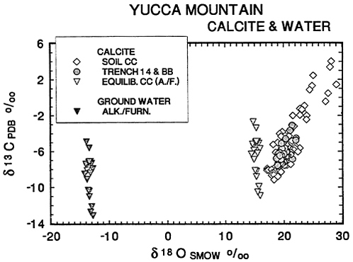
Figure 2.9 Plot of δ13CPDB vs δ18OSMOW for ground waters of Alkali Flat/ Furnace Creek flow systems, and Yucca Mountain vein calcites and soil calcites. Yucca Mountain calcite data from Whelan and Stuckless (1990), Quade and Cerling (1990), and Quade et al. (1989). The values of calcite in isotopic equilibrium with analyzed ground-waters (equilib. cc) were calculated for 25 °C with 1000 ℓn α (18O/16O) for CaCO3 − H2O = 28.5 and (13C/12C) for HCO3- − CaCO3 = −2.2 (Friedman and O'Neil, 1977). Ground-water analyses from Benson and McKinley (1985). PDB refers to the standard by which the carbon isotopic content of carbonates and water is measured.
The results showed a consistent relationship between the depth of the calcite and the content of 18O and 13C, with δ18O decreasing and δ13C increasing with greater depth. Preliminary analyses of strontium isotopic ratios showed a clear distinction in strontium isotopic composition between calcites below the water table and those above. The calcites above the water table showed a narrow range of 87Sr/ 86Sr composition (0.7106 to 0.7128) that overlaps the range of soil calcite and the calcite veins of Trench 14. Samples from 600 m to 1,200 m below the water table had Sr values similar to the low end of the range for waters from the Tertiary/Quaternary aquifers of the Alkali Flat/Furnace Creek ground-water subsystem.
These results lead the panel to conclude that the water table remained relatively stable over the period of time during which and since the secondary calcite was deposited.
It was reported that some inconsistent results were obtained in the 13C abundances from core samples above the water table; they were in the range usually found at depths below the water table. The significance of these “outliers” is not presently clear, as nearby core samples from above the water table do not indicate a rise in the water table. The small amount of dissolved carbon in ground water and the possibility of isotopic exchange between dissolved carbon and local wall rock make variations subject to a wide range of possible causes. Moreover, the ages of the calcites have not been determined. The calcites with inconsistent 13C content may have formed as a result of hydrothermal activity that occurred millions of years ago, soon after deposition of the volcanic rock as was seen at Harper Valley discussed earlier in this chapter.
CONCLUSIONS
Taking into account the expert testimony at its meetings, published information, and what was observed on the field trips and analyzed independently by panel members, the panel found no compelling evidence for the widespread discharge of deep ground water in the vicinity of Yucca Mountain that would have resulted if the regional water table had been elevated to a height sufficient to cause flow of water along the fault exposed in Trench 14 at an elevation of about 1,150 m AMSL (above mean sea level). For comparison, the estimated elevation of the present water table beneath Trench 14 is about 730m, and the design elevation of the floor of the proposed MGDS ranges from about 950 to 1,150 m (Dudley, pers. comm., 1991). Indeed, in the panel's opinion, the morphologic, textural, mineralogic, and isotopic evidence is strong that the fault-filling
materials formed by evaporation of descending meteoric water that only partly filled near-surface open fractures in the unsaturated zone.
Surficial calcite deposits consistently show a correlation between thicker surface-parallel calcretes occurring in better developed soil horizons and progressively older ground surfaces. The widespread occurrence of root casts within the calcretes associated with Bk or K soil horizons confirms that the calcium-rich waters concentrated in the soil zone rather than on the surface. This is characteristic of infiltrating rain water, not of ascending pressurized thermal waters. These observations lead the panel to conclude that surface-parallel calcretes in soils originated from meteoric water by surficial soil-forming process rather than from upwelling ground water.
In the panel's view, those breccias that appear to have formed in response to hydrothermal processes in the vicinity of Yucca Mountain and Busted Butte originated at the time of emplacement of the ash-flow tuff sequence from 13-10 Ma. They formed as a result of rapid heating of locally derived ground and rain waters. The source of energy appears to have been the heat initially contained in the tuffs, rather than the thermal and mechanical energy in the postulated hot water from a source many kilometers deep.
Younger breccias formed by a variety of processes through time, many of which show evidence of surficial water and progressive carbonate accumulation.
A variety of evidence, outlined earlier in this chapter, indicates that the water table in Devils Hole (presently 16 m below the surface) has varied less than 9 m in the past 45 ka and probably has not risen to the land surface in the past several hundred thousand years. Considering that Devils Hole is located in the same active tectonic region, and is extending at two to three times the rate of the Yucca Mountain area, the fact that earthquakes have not resulted in even a 15 m rise in the Devils Hole water table inspires serious doubt that the seismic pumping mechanism can cause a greater than 100 m rise in the water table in the Yucca Mountain area.
The currently active spring at Site 199 may rise from a perched water table. The isotopic composition of Cane Spring water is significantly different from that of ground water in the Alkali Flat/ Furnace Creek and Ash Meadows aquifer, but similar to that of local rain water, modified by evaporation. The gypsum deposits at Wahmonie are ancient and probably formed well before the present erosion cycle. The panel concludes that none of the springs or spring deposits in the Yucca Mountain area provide evidence of origin from ascending deep-seated ground water.
Isotopic evidence shows that none of the surficial calcite depos-
its analyzed to date could have precipitated from known ground waters. The analyzed deposits, including those at Trench 14 and Busted Butte that inspired the upwelling hypothesis, show isotopic affinities with local soils and pedogenic carbonates.
The panel concludes that to date the preponderance of evidence supports the view that the calcretes and other secondary carbonates in veins of the area formed from meteoric water and surface processes. The evidence cited here has convinced the panel that the ground-water level at the proposed Yucca Mountain repository site has not reached or exceeded the level of the proposed repository at any time during the last 100 ka.
RECOMMENDATIONS
The panel has identified some studies that may be useful. Because only a small number of the site characterization study plans are available, the panel is not aware of all the studies that are planned. If, therefore, some recommendations include studies that are already planned, these recommendations may be viewed as endorsements of the project plans.
The panel recommends that further efforts in the study of secondary calcite deposits be refocused. In the panel's opinion, it is well established that surface calcite deposits at Yucca Mountain, such as those at Trench 14 and Busted Butte, did not precipitate from ground waters sampled in deep wells.
Evidence for the isotopic concentrations of ancient ground waters is incomplete, however. It is recommended that analyses of calcite veins intersected in drill cores be carried out for δ18OVSMOWand δ13CPDB, as well as of fluid inclusions. Age dating with U and Th isotopes would be an essential part of this study to reconstruct the ground-water history of the Yucca Mountain area.
Additional Characterization of Carbonate Veins in Core
The panel strongly endorses the efforts that are under way to characterize the ages and isotopic compositions of calcites in core obtained from both above and below the present water table. Along with the isotopic and age results, information should be obtained on grain sizes, chemical variations found in the carbonates (particularly Ca-Mg-Mn-Sr), and whether or not fluid inclusions are present.
Fluid Inclusion Studies
Fluid inclusions provide samples of ancient waters that were present at the time of entrapment. Information on the temperature and chemistry of the water at the time of mineral crystallization may be obtained from analysis of these inclusions. A search should be made for suitable fluid inclusions in vein materials found in core to extract for hydrogen isotope analyses. The isotopic composition of the corresponding oxygen in the inclusion water can be calculated from the oxygen isotopic composition of the host mineral. The panel is aware that vein materials that contain mixtures of primary and secondary fluid inclusions that formed at different times (or that contain more than one generation of secondary fluid inclusions) are not suitable for this type of analysis unless the volume percent of one type of inclusion is much greater than that of the other.
Isotopic Composition of Windblown Dust
Windblown particles that have been collected over a long period of time in dust traps in the vicinity of Yucca Mountain should be analyzed to determine if the average isotopic composition of this dust is essentially the same or significantly different from that of pedogenic carbonates and rock units exposed in the region. This study also would provide information about the possible extent to which windblown dust might influence the isotopic composition of meteoric water percolating downward through the vadose zone.
Additional Studies at Site 199
Detailed studies should be carried out to describe and document the geology, hydrology, and geochemistry of the apparent spring deposit at Site 199. Trenching and drilling of the tufa mound at this locality should be a high priority to determine if a perched water table is present, and if carbonate is currently depositing or has deposited in veins underground. This information will be valuable as an aid in further understanding the paleohydrology of the region. The hydrologic history of the region is essential, as understanding the past will bear on predicting future changes in the hydrologic system.
REFERENCES
Allen, E. T., and A. L. Day. 1935. Hot springs of the Yellowstone National Park. Carnegie Institution of Washington Publication 466. 525 pp.
Archambeau, C. B., and Price, N. J. 1991. An Assessment of J. S. Szymanski's Conceptual Hydrotectonic Model, Minority Report of the Special DOE Review Panel. September. 144 pp. plus appendix.
Arnorsson, S. 1978. Precipitation of calcite from flashed geothermal waters in Iceland Contributions to Mineralogy and Petrology 66: 21–28.
Axen, G. J., W. J. Taylor, and J. M. Bartley. 1991 . Space-time patterns of the onset of extension and magmatism, southern Great Basin, Nevada, Utah, and California. Geological Society of America Abstracts with Programs. 26: (6) A190.
Bargar, K. E. 1978. Geology and thermal history of Mammoth Hot Springs, Yellowstone National Park, Wyoming. U.S. Geological Survey Bulletin 1444. 55 pp.
Bargar, K. E., and M. H. Beeson. 1984. Hydrothermal alteration in research drill hole Y-6, Upper Firehole River, Yellowstone National Park, Wyoming. U.S. Geological Survey Professional Paper 1054-B, pp. B1-B24.
Beatley, J. C. 1976. Vascular Plants of the Nevada Test Site, and Central-Southern Nevada National Technical Information Service Report TID-26881. 308 pp.
Benson, L. V., and H. Klieforth. 1989. Stable isotopes in precipitation and ground water in the Yucca Mountain region, Nevada - paleoclimatic interpretation In Aspects of Climate Variability in the Pacific and W. Americas. D. H. Peterson, ed. American Geophysical Union, Monograph 55. pp. 41-49.
Benson, L. V., and P. W. McKinley. 1985. Chemical composition of ground water in the Yucca Mountain area, Nevada, 1971-84. U. S. Geological Survey Open-File Report 85-484. 10 pp.
Benson, L. V., J. H. Robinson, R. K. Blankennagel, and A. E. Ogard. 1983. Chemical composition of ground-water and the locations of permeable zones in the Yucca Mountain Area, Nevada U. S. Geological Survey Open-File Report 83-484. 19 pp.
Burk, C. A. 1952. The Big Horn hot springs at Thermopolis, Wyoming. In Wyoming Geological Association Guidebook Seventh Annual Field Conference, pp. 93–95.
Chafetz, H. S., and R. L. Folk. 1984. Travertines: Depositional morphology and bacterially constructed constituents. Jour. Sed. Petrology 54: 289-316.
Clayton, R. N., J. R. Goldsmith, K. J. Johnson, and R. C. Newton. 1972. Pressure effect on stable isotope fractionation. Abstracts of the American Geophysical Union 53: 555.
Claasen, H. C. 1985. Sources and mechanisms of recharge for ground-water in the west central Amargosa Desert, Nevada: A geochemical interpretation U. S. Geological Survey, Professional Paper 712-F, pp. F1-F31.
Claasen, H. C. 1986. Late-Wisconsin paleohydrology of the west-central Amargosa Desert, Nevada, USA. Chem. Geol. 58: 311-323.
Dettinger, M. D. 1989. Distribution of Carbonate-Rock Aquifers in Southern Nevada and the Potential for their Development. Summary of Findings, 1985-88. U.S. Geological Survey, and Desert Research Institute, Univ. of Nevada, Program for the Study and Testing of Carbonate-Rock Aquifers in Eastern and Southern Nevada. Summary Report No. 1
Dudley, W. W. 1991. Personal Communication. U.S. Geological Survey.
Ellis, A. J., and W. A. J. Mahon. 1977. Chemistry and Geothermal Systems. New York, Academic Press. 392 pp.
Engebretson, D. C., A. Cox, and R. G. Gorden. 1985. Relative motions between oceanic and continental plates in the Pacific basin. Geological Society of America. Special Paper 206. 59 pp.
Fournier, R. O. 1985a. The behavior of silica in hydrothermal solutions. In Geology and Geochemistry of Epithermal Systems. B. R. Berger and P. M. Bethke, eds. Reviews in Economic Geology 2: 45–61.
Fournier, R. O. 1985b. Carbonate transport in the epithermal environment. In Geology and Geochemistry of Epithermal Systems. B. R. Berger and P. M. Bethke, eds. Reviews in Economic Geology 2: 63–72.
Frazier, G. 1990. Personal Communication. Formerly with Science Applications, Inc.
Friedman, I., and J. R. O'Neil. 1977. Compilation of stable isotope fractionation factors of geochemical interest. In Data of Geochemistry, 6th ed. M. Fleischer, ed. U. S. Geol. Surv. Prof. Paper 440-K.
Frizzell, V. A., Jr., and J. Shulters. Geologic map of the Nevada Test Site, southern Nevada. U.S. Geological Survey Map I-2046.
Gile, L. H., F. F. Peterson, and R. B. Grossman. 1965. The K horizon—A master soil horizon of carbonate accumulation. Soil Science 99: 74-82.
Gile, L. H., F. F. Peterson, and R. B. Grossman. 1966. Morphological and genetic sequences of carbonate accumulation in desert soils. Soil Science 101: 347-360.
Hamilton, W. 1969. Mesozoic California and the underflow of Pacific mantle. Geological Society of America 80: 2409-2430.
Haynes, C.V. 1967. Quaternary geology of the Tule Springs area, Clark County, Nevada In Pleistocene Studies in Southern Nevada. H. M. Wormington, and D. Ellis, eds. Nevada State Museum Anthropological Papers 13: 15-104.
Ingraham, N. L., R. L. Jacobson, J. W. Hess, and B. F. Lyles. 1990. Stable isotopic study of precipitation and spring discharge on the Nevada Test Site. Desert Research Institute, Publication 45078, University of Nevada.
Jones, B. F. 1983. Occurrence of clay minerals in surficial deposits of southwestern Nevada. Sciences Geologiques, Memoire 12: 81-92.
Keith, T. E. C., and L. J. P. Muffler. 1978. Minerals produced during cooling and hydrothermal alteration of ash flow tuff from Yellowstone drill hole Y-5. Journal of Volcanology and Geothermal Research 3: 373–402.
Keith, T. E. 1991. Personal Communication.
Khoury, H. N., D. D. Eberl, and B. F. Jones. 1982. Origin of magnesium clays from the Amargosa Desert, Nevada. Clays and Clay Minerals 30: 327–336.
Lattman, L. H.. 1973. Calcium carbonate cementation of alluvial fans in southern Nevada Geological Society of America Bulletin 84: 3013-3028.
Levy, S. 1991. Mineralogic alteration history and paleohydrology at Yucca Mountain, Nevada. In Proceedings of the Second Annual International High Level Radioactive Waste Management Conference 1: 477-485.
Levy, S., and C. Naeser. In press. Bedrock breccias along fault zones near Yucca Mountain, Nevada. U.S. Geological Survey Bulletin.
Ludwig, K. R., K. R. Simmons, B. J. Szabo, and A. C. Riggs. 1990. Mass-spectrometric 230Th - 234U - 238U dating of the Devils Hole calcite vein: a precise record of continuous growth from ~566 Ka to 60Ka Geol. Soc. Amer. Abstracts with Programs 1990 A310.
Lyles, B. F., J. Edkins, R. L. Jacobson, and J. W. Hess. 1990. Time-series analysis of ion and isotope geochemistry of selected springs of the Nevada Test Site, Nye Co., Nevada Desert Research Institute Publication 45068. University of Nevada.
Machette, M.N. 1978. Dating Quaternary faults in southwestern United States using buried calcic paleosols. United States Geological Survey Journal of Research 6: (3)369-381.
Machette, M. N. 1985. Calcic soils of the southwestern United States. Geological Society of America Special Paper 203, pp. 1-21.
Marshall, B. D., Z. E. Peterman, K. Futa, J. S. Stuckless, S. A. Mahan, J. S. Downey, and E. D. Gutentag. 1990. Origin of carbonate deposits in the vicinity of Yucca Mountain, Nevada: Preliminary results of strontium-isotope analyses In Proceedings of the American Nuclear Society International Meeting on High Level Radioactive Waste Management 2: 921-923.
McFadden, L.D., and J. C. Tinsley. 1985. Rate and depth of pedogenic-carbonate accumulation in soils - formulation and testing of a compartment model. Geological Society of America Special Paper 203, pp. 23-41.
McFadden, L. D., S. G. Wells, and J. C. Dohrenwend. 1986. Influence of Quaternary climate changes on processes of soil development on desert loess deposits of the Cima volcanic field, California Catena. 13: 361-389.
McFadden, L. D., S. G. Wells, and M. L. Jercinovich. 1987. Influences of eolian and pedogenic processes on the origin and evolution of desert pavements. Geology 15: 504-508.
Muhs, D. R., J. W. Whitney, R. R. Shroba, E. M. Taylor, and C. A. Bush. 1990. Uranium-series dating of secondary carbonates near Yucca Mountain, Nevada: Applications to tectonic, paleoclimatic, and hydrologic problems In Proceedings of the American Nuclear Society International Meeting on High Level Radioactive Waste Management 2: 924-929.
Quade, J., T. E. Cerling, and J. R. Bowman. 1989. Systematic variations in the carbon and oxygen isotopic composition of pedogenic carbonate along elevation transects in the southern Great Basin, United States Geol. Soc. Am. Bull. 101: 464–475.
Quade, Jay, and T. E. Cerling. 1990. Stable isotope evidence for pedogenic origin of fracture-filling carbonates in Trench 14 near Yucca Mountain, Nevada Science 250: 1849-1552
Quade, J., and T. E. Cerling. 1991. Personal Communication. University of Utah.
Reheis, M. 1990. Personal Communication. U. S. Geological Survey
Riggs, A. C. 1992. Personal Communication. U. S. Geological Survey
Scott, R. B. 1990. Tectonic setting of Yucca Mountain, southwest Nevada. In Basin and Range Extensional Tectonics near the latitude of Las Vegas, Nevada. B. P. Wernicke ed. Geological Society of America Memoir 176: 251-282.
Simmons, S. F. 1990. Platy calcite as an indicator of boiling in epithermal deposits: Evidence from New Zealand geothermal systems Geological Society of America Abstracts with Programs 22: A42.
Slate, J. L., W. B. Bull, T. L. Ku, M. Shafiqullah, D. J. Lynch, and Y. P. Huang. Soil-carbonate genesis in the Pinacate volcanic field, northwestern Sonora, Mexico. Quaternary Research 35: 400-416.
Sowers, J. M. 1985. Pedogenic Calcretes of the Kyle Canyon Alluvial Fan, Southern Nevada - Morphology and Development Ph.D. thesis, University of California, Berkeley. 160 pp.
Stuckless, J. S. 1991. An evaluation of evidence pertaining to the origin of vein deposits exposed in Trench 14, Nevada Test Site, Nevada In Proceedings of the International High Level Radioactive Waste Management Conference, 2: 1429-1438.
Swadley, W. C., D. L. Hoover, and J. N. Rosholt. 1984. Preliminary report on late Cenozoic faulting and stratigraphy in the vicinity of Yucca Mountain, Nye County, Nevada U. S. Geological Survey Open-File Report 84-788. 42 pp.
Syers, J. K., S. L. Chapman, M. L. Jackson, R. W. Rex, and R. N. Clayton. 1968. Quartz isolation from rocks, sediments and soils for determination of oxygen isotopic composition. Geochim. Cosmochim. Acta 33: 1022-1025.
Szabo, B. J., and T. K. Kyser. 1990. Ages and stable isotope compositions of secondary calcite and opal in drill cores from Tertiary volcanic rocks of the Yucca Mountain area, Nevada Geol. Soc. Amer. Bulletin 102: 1714-1719.
Szymanski, J. S. 1989. Conceptual Considerations of the Yucca Mountain Ground
water System with Special Emphasis on the Adequacy of This System to Accommodate a High-Level Nuclear Waste Repository. Unpublished DOE report.
Szymanski, J. S. 1991. Written Communication. U. S. Department of Energy.
Taylor, E. M. 1986. Impact of Time and Climate on Quaternary Soils in the Yucca Mountain Area of the Nevada Test Site University of Colorado, Boulder. Unpublished M.S. thesis. 217 pp.
Taylor, E. M., and H. E. Huckins. 1986. Carbonate and opaline silica fault-filling on the Bow Ridge fault, Yucca Mountain, Nevada—deposition from pedogenic processes or upwelling groundwater? (abs.) Geological Society of America Abstracts with Programs, 18: 418.
Turrin, B. D., D. E. Champion, and R. J. Fleck. 1991. 40Ar/39Ar age of the Lathrop Wells volcanic center, Yucca Mountain, Nevada Science 253: 654-657.
Vaniman, D. T., D. L. Bish, and S. Chipera. 1988. A preliminary comparison of mineral deposits in faults near Yucca Mountain, Nevada, with possible analogs. Los Alamos National Laboratory Report LA-11289-MS. 54 pp.
U. S. Department of Energy. 1988. Site Characterization Plan: Yucca Mountain Site, Nevada Research and Development Area, Nevada, DOE/RW 0199, Office of Civilian Radioactive Waste Management. Washington, D.C.
U.S. Soil Conservation Service. 1970. Soils in the United States. In National Atlas of the United States. U.S. Geological Survey, Washington, D. C., pp. 85-88.
Waring, G. A. 1915. Springs of California. U.S. Geological Survey Water-Supply Paper 338. 410 pp.
Wells, S. G., L. D. McFadden, C. E. Renault, and B. M. Crowe. 1990. Geomorphic assessment of late Quaternary volcanism in the Yucca Mountain area, southern Nevada. Implications for the high-level radioactive waste repository. Geology 18: 549-553.
Wernicke, B., G. J. Axen, and J. K. Snow. 1988. Basin and Range extensional tectonics at the latitude of Las Vegas, Nevada. Geological Society of America Bulletin 100: 1738-1757.
Wernicke, B., and Six others. 1989. Extensional tectonics in the Basin and Range province between the southern Sierra Nevada and the Colorado Plateau Field Guide T138. 28th International Geological Congress. 80 pp.
Whelan, J. F., and J. S. Stuckless. 1990. Reconnaissance δ13C and δ18O data from Trench 14, Busted Butte, and drill hole G-4, Yucca Mountain, Nevada Test Site Proceedings of the American Nuclear Society International Meeting on High Level Radioactive Waste Management 2: 930-933.
Winograd, I. J., and F. J. Pearson, Jr. 1976. Major carbon 14 anomaly in a regional carbonate aquifer: Possible evidence for megascale channelling, south-central Great Basin Water Resources Research 12: 1125-1143.
Winograd, I. J., and B. J. Szabo. 1988. Water-table decline in the south-central Great Basin during the Quaternary: Implications for toxic waste disposal In Geologic and hydrologic investigations of a potential nuclear waste disposal site at Yucca Mountain, southern Nevada M. D. Carr and J. C. Yount, eds. U.S. Geological Survey Bulletin 1790: 147-152.
Winograd, I. J., B. J. Szabo, T. B. Coplen, and A. C. Riggs. 1989. A 250,000-year climate record from Great Basin vein calcite: Implications for Milankovitch theory. Science 242: 1275-1280.
Wright, L. A., R. E. Drake, and B. W. Troxel. 1984. Evidence for the western migration of severe Cenozoic extension, southeastern Great Basin, California. Geological Society of America Abstracts with Programs, 16: 701.
Wright, L.A., B. W. Troxel, B. C. Burchfiel, R. Chapman, and T. Labotka. 1981. Geologic cross-section from the Sierra Nevada to the Las Vegas Valley, eastern California to southern Nevada Geological Society of America Map and Chart Series MC-28M.


