
2
The Study Area and Patterns of Water Use
The area under study is part of the Middle East, consisting of Israel, Jordan, and the West Bank and Gaza Strip (see Figure 2.1). For simplicity, this area is referred to in this report as ''the study area."
Because of various historical and political constraints, data on study area population, and economic and hydrologic features have been difficult to collect and analyze in a common and consistent manner. Many of the quantitative data presented in this report have been contributed by committee members or extracted and modified from a recent report prepared for the Multilateral Working Group on Water Resources and funded by the German Government (CES Consulting Engineers and GTZ [Association for Technical Cooperation], 1996). The German study was prepared by a consulting firm with input from separate Israeli, Jordanian, and Palestinian study teams, and represents the latest and most comprehensive appraisal of the water situation in the study area. While quantitative data from the German study have been used extensively in the present study, the introduction to the German report describes problems in producing study area data because of discrepancies in the interim reports prepared by the individual study teams. No efforts have been made to verify or significantly modify these data for the present report. Use of data from the Multilateral Working Group does not infer endorsement of the validity of that committee's data or findings.
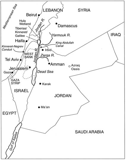
FIGURE 2.1 The study area—Israel, Jordan, the West Bank and Gaza Strip.
SOURCE: Redrawn from published maps.
Population and Economy
As of 1995, the combined population in the study area was about 12 million (Table 2.1). Population distribution is highly variable; for the most part, population centers are confined to areas of higher precipitation
TABLE 2.1 Socioeconomic Profile of the Study Areaa
|
Characteristics |
Israel |
West Bank and Gaza Strip |
Jordan |
|
Population (in millions) |
5.54 |
2.54 |
4.33 |
|
Literacy (percent) |
95 |
84 |
87 |
|
Gross Domestic Product (GDP)a |
85.7 |
2.98 |
20.9 |
|
Composition by Sector (percent) |
|||
|
Agriculture |
3.5 |
33 |
6 |
|
Industry |
22 |
25 |
28 |
|
Services |
74.5 |
42 |
66 |
|
Per Capita (US$) |
16,400 |
1,300 |
5,000 |
|
Distribution of Workforce (percent) |
|||
|
Agriculture |
3.5 |
14.1 |
7.4 |
|
Industry |
22.1 |
16.2 |
11.4 |
|
Commerce |
13.9 |
18.2 |
10.5 |
|
Construction |
6.5 |
19.1 |
10 |
|
Transport and Communication |
6.3 |
4.8 |
8.7 |
|
Other Services |
47.7 |
27.6 |
52 |
|
a GDP in billion USS; all numbers are for gross comparison only, are based on various sources and reporting years, and may not be fully consistent. SOURCE: Source of data for Israel and Jordan is the CIA Factbook, 1997 (http://www.odci.gov/cia/publications/factbook/country-frame.html). Source of data for West Bank and Gaza Strip is the Palestinian Central Bureau of Statistics (http://www.pcbs.org/english/sel_stat.htm) except for data on GDP composition by sector, which are from the CIA Factbook, 1997. |
|||
In Israel, more than 90 percent of the population lives in urban localities with the remainder living in rural communities. In Jordan, approximately 78 percent live in urban areas and 22 percent in rural communities. In the West Bank and Gaza Strip, 29 percent live in urban areas, 65 percent live in rural communities, and 6 percent presently (1997) live in refugee camps. The Gaza Strip, where most of the inhabitants live in refugee camps, is one of the most densely populated areas in the world, with an average population per square kilometer of nearly 2,200 people.
An estimated economic profile of the study area is shown in Table 2.1. The higher Israeli per capita gross domestic product (GDP) denotes an advanced economy relative to the remainder of the study area. As will be apparent throughout this report, the effect of this economic difference on the development of water resources is significant and contradictory.
For example, within Israel, the availability of running water to virtually the entire population all the time and the widespread access to water-using appliances have led to relatively high per capita water consumption. On the other hand, the robust Israeli economy has allowed for
infrastructure development and agricultural research that have reduced the quantity of potable water used for irrigation per hectare and per production unit. Palestinians and Jordanians, in contrast, with less access to reliable running water and water-using appliances, have lower per capita water consumption but use relatively more potable water for agriculture because of less efficient irrigation systems and a lack of alternative sources (for example, reclaimed wastewater from urban uses).
Agriculture plays a relatively small to moderate economic role in the study area (Table 2.1). However, as will be shown in a section below, agriculture is the principal user of water. In Israel, agriculture accounts for less than 4 percent of the workforce, 3 percent of the gross domestic product (GDP), and 57 percent of the water used (excluding wastewater); in the West Bank and Gaza Strip, 14 percent of the workforce, 33 percent of GDP, and 64 percent of water used; and in Jordan, 7 percent of the workforce, 6 percent of the GDP, and 72 percent of the water used (excluding wastewater). Improvements in irrigation efficiency, increased crop productivity, changes in the types of crops grown (including an increased reliance on dryland farming), and continued growth of wastewater and brackish water irrigation are all clearly required to reduce the freshwater used in agriculture insofar as needed for the growth of other economic sectors and improved living standards and the natural environment.
Economic growth and improved living standards are universal and natural aspirations. Indeed, economic parity and growth throughout the study area are implicit goals of the various multilateral and bilateral peace negotiations. Moves toward parity will tend to increase consumption of water in Jordan and the West Bank and Gaza Strip, thereby placing additional burdens on already-strained water resources. Measures to manage water demand, described later in this report, need to be applied both to lower water consumption in Israel without significantly degrading the standard of living and to minimize increased consumption in Jordan and the West Bank and Gaza Strip while improving the standard of living. If such measures are not taken, economic growth in the study area is likely to be affected by a deficient or expensive water supply.
The study area lacks significant energy resources other than very limited gas fields and undeveloped deposits of oil shale. Electricity is generated almost exclusively with fossil fuels that are imported and therefore costly. Except for the gravity flow of water from the Yarmouk River to the King Abdullah Canal in the Jordan Valley, all water development in the area requires pumping. Because much of the freshwater exists below sea level (in the Upper Jordan River Basin), pumping costs are significant. For example, in Israel, more than 7 percent of the total electricity production is used to transport water. Of the technologies that might
be used to augment the supply of water in the study area, some of the more promisingæwastewater reclamation, desalination, and water transfersæare all energy-intensive.
Landscapes
The region has a hot, dry climate, consisting of a dry coast and strip of dry forest upland grading into semidesert and desert. As shown in Figure 2.2, most of the study area is classified as subtropical scrubland, semidesert, and desert. To the north there is an area of temperature steppe and semidesert, and to the south a large expanse of desert, stretching from Egypt into Saudi Arabia. To the southwest the Nile delta abuts, and to the distant east the great neighboring floodplains of the Tigris-Euphrates carry water from Turkey.
The Mediterranean coast is fringed by a gently rolling plain, 15 to 25 kilometers (km) wide, covered by sparse woodland and shrub vegetation. The brown soils of the coastal plain are sandy, requiring large quantities of water and fertilizer to be productive. The plain has a mean altitude of about 50 meters (m) above sea level and gives way to steppe with grassy cover on black and chestnut soils overlying limestone. The steppe gradually rises to form a mountainous upland area with an average altitude of 600 m and having several peaks higher than 1,000 m. The steeper mountain slopes of this upland have been severely eroded and are mostly barren. Soils in the upland limestone areas tend to be shallow, stony, and suitable only for pasture and nonmechanized farming. Alluvial soils in the larger valleys are more suitable for agriculture. The eastern part of the upland is a semidesert with poor soil development.
The transition to the Rift Valley (a part of the Syrian-African rift), east of the uplands is sharp, with land altitudes falling from 600 m above sea level to 200 to 400 m below sea level over a distance of about 15 km. The Rift Valley, a continuation of Africa's Great Rift Valley, contains Lake Kinneret/Lake Tiberias/Sea of Galilee, which is 200 m below sea level, and the Dead Sea, with the world's lowest land altitude of 400 m below sea level. The land parts of the Rift Valley are underlain by fertile alluvial soils, but requiring irrigation to be agriculturally productive.
East of the Jordan Rift Valley is an upland area whose western edge forms an escarpment rising more than 1000 meters above the valley floor and with peaks exceeding 1000 m above sea level. This upland area is 30 to 50 km across and is covered with sparse forest and shrub vegetation. Soil development is generally poor here, except in the northern part, where weathering of basaltic rocks has formed rich, brown soils in some of the larger valleys containing alluvial soils. This upland area grades into a relatively featureless rock-and gravel-covered steppe with altitudes
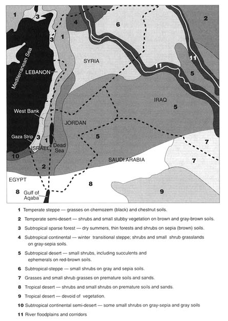
ranging from 500 to 700 m above sea level. Vegetation cover is limited to small shrubs. This area is part of the subtropical desert that makes up most of the eastern and southern portions of the study area.
Thus, the natural landscapes of the study area are diverse, although the prevailing visual impression is that of a dry, semiforested coastal highland grading into semidesert and desert. Soil development and natural vegetation, which are largely a factor of climate (see discussion immediately following) are severely limited in much of the area. Naturally arable land is found over 20 percent of the area west of the Jordan Rift Valley and 10 percent east of the valley.
Climate
The study area lies in a transition zone between the hot and arid southern part of West Asia and the relatively cooler and wet northern Mediterranean region. As a result, there is a wide range of spatial and temporal variation in temperature and rainfall. The climate of much of the northwestern part of the area is typically Mediterranean, with mild, rainy winters and hot, dry summers; the eastern and southern parts are much drier, and seasonal temperatures more extreme. Rain occurs in the study area from October to May. Maximum rainfall in the more humid northwestern part occurs in January; the sparse rainfall in the eastern and southern parts is more evenly distributed over the rainy season. Throughout the study area, summers are completely dry, requiring irrigation for crop production.
Mean annual precipitation in the study area is shown in Figure 2.3. Average annual rainfall varies from less than 30 millimeters (mm) in the southern and eastern parts of the study area to locally as much as 1,100 mm in the northwestern part. The average annual rainfall in the central and northern highlands west of the Jordan Rift Valley ranges from 200 to 1,000 mm and ranges in the highlands east of the valley from 200 to 600 mm. Rainfall along the Mediterranean coast ranges from 300 mm in the south to 600 mm in the north. In the southern inland areas, rainfall ranges from 250 mm to 25 mm annually. About 90 percent of the total area east of the Jordan Rift Valley receives less than 200 mm of annual precipitation, and more than 60 percent of the area west of the Rift Valley receives less than 250 mm annually. As is typical of arid and semi-arid climates, there is considerable interannual variability in rainfall.
The variability of precipitation over time is shown in Figure 2.4. This graph, which shows average annual precipitation for the area west of the Jordan Rift Valley, is typical of the entire study area. Precipitation in wet years is almost three times that of dry years. A five- year running mean filters nearly two-thirds of the large year-to-year variation. Nevertheless,
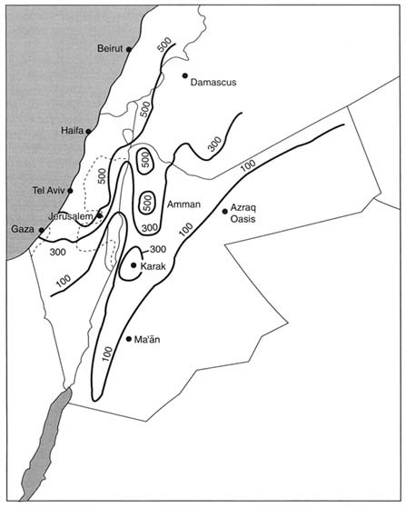
FIGURE 2.3 Mean annual rainfall in the study region in millimeters (mm). Local variations associated with topographic features, including small areas that receive 1,000 mm or more of rain annually, are not mapped. Note that much of the region receives less than 300 mm (11.8 inches) per year. For comparison, mean annual rainfall exceeds 300 mm over about two-thirds of the land area of the United States and over most of Europe. SOURCE: Complied from information in Salameh and Bannayan, 1993 and U.S. Central Intelligence Agency, 1993.
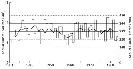
FIGURE 2.4 Annual rainfall in Palestine/Israel, 1931-1984. Solid graphed line connects 5-year running mean. Central horizontal line shows mean value for series; intermediate horizontal line (longer dashes) shows mean ± one standard deviation; top and bottom horizontal lines (shorter dashes) show mean ± two standard deviations. SOURCE: Stanhill and Rapaport, 1988.
because of the lack of significant year-to-year water storage (other than ground water), this variability is a major factor in water-supply planning in the study area.
Summer temperatures are high throughout the study area, generally in the range of 18°C to 32°C, except in the Jordan Valley, where summer temperatures may be as high as 45°C. In the winter, temperatures average about 14°C along the Mediterranean coast and about 9°C at higher altitudes; winter temperatures in the Jordan Valley often exceed 25°C during the day and can be as low as 7°C at night. Temperatures below freezing may occur in upland areas where land elevation exceeds about 500 m above sea level, but they are rare at lower altitudes.
Solar radiation is very high (20 to 30 million joules/m2/day) in the generally cloudless summer months (April through September) and consequently open water evaporation is high in the summer, accounting for as much as 70 percent of the annual total evaporation. Because more water is potentially lost through evaporation than added by precipitation, the study area displays desert characteristics. According to a recent study (Cohen and Stanhill, 1996), solar radiation in the northern Jordan Valley has declined significantly in the past 30 years, possibly owing to greater
air pollution. The reduced solar radiation has notably reduced open water evaporation. This observation is potentially significant because, as shown below, the northern Jordan Valley and adjacent highlands are the most important sources of water for the study area.
Hydrology
Precipitation falling on land is either returned directly to the atmosphere by evaporation, flows along the land surface to become surface water, or soaks into the ground. Water that infiltrates into the ground is either drawn into plants and returned to the atmosphere by transpiration or continues infiltrating, becoming ground water. Ground water moves through the earth, eventually re-emerging to the surface in streams, as springs, or as discharge to lakes or the sea. Humans alter the hydrologic cycle by removing surface and ground water, building reservoirs, reintroducing water as sewage discharge to both surface and ground water, and creating additional freshwater through artificial desalination.
Precipitation and Evapotranspiration
According to Stanhill and Rapaport (1988) the volume of annual precipitation in the part of the study area west of the Jordan Rift Valley is about 7,900 million cubic meters (million m3), based on an average rainfall of 293 mm per year over the 27,011 km2 area. For the area east of the Rift Valley, the volume of annual precipitation is almost 8,500 million m3, based on an average rainfall of 94 mm per year over the 89,900 km2 area (Water Authority of Jordan, 1996 Annual Report). Total precipitation over the study area is therefore about 16,400 million m3 per year (million m3/yr). Only a small percentage of this water can be used directly by humans. The high evaporation rates in the study area, combined with transpiration of soil moisture by plants, returns most of the precipitation directly to the atmosphere before it can infiltrate below the soil zone (in "ground-water recharge") or flow directly to wadis, streams, or lakes (as "stormwater runoff").
Evaporation rates from open water bodies can be measured. They have been found to range from about 1,550 mm along the Mediterranean coast, to more than 4,400 mm per year in eastern Jordan. These open water, or maximum potential, evaporation rates far exceed precipitation rates shown in Figure 2.3. In assessing water balance, the combined effects of actual evaporation and plant transpiration ("evapotranspiration") from land areas is a more meaningful measurement than open water evaporation. Useful information on evapotranspiration can be derived from measurements or estimates of the other components in the hydrologic
cycle (precipitation, ground-water recharge, and stormwater runoff). Such analyses, based on locally measured hydrologic data, indicate that average annual evapotranspiration in the study area ranges from 50 to 100 percent of precipitation.
In some arid parts of the study area, such as the southern and eastern deserts, 100 percent of the precipitation returns to the atmosphere by evaporation and transpiration. It is obvious that in these areas, sustainable water supplies cannot be developed without resorting to engineering schemes, such as artificially recharging stormwater before it can evaporate. In other parts of the study area, such as the seasonally humid highlands adjacent to the Jordan Rift Valley, about 70 percent of the precipitation is lost through evapotranspiration. In the sandy, flat, Mediterranean coastal areas, evapotranspiration may be as low as 50 percent of the rainfall. In these areas, sustainable water supplies can be developed by utilizing the precipitation that is not evaporated or transpired. For the area west of the Rift Valley, less than 25 percent of the annual average precipitation is available for human use. East of the Rift Valley, less than 10 percent of the precipitation is available (Al-Weshah, 1992). In the study area as a whole, no more than 17 percent of the 16,400 million m3/yr of precipitation is available as an average renewable resource (see the summary discussion below on available water in the area). This water is available either as ground water or stormwater runoff.
Ground Water
Precipitation that infiltrates into the ground and percolates below the root zone eventually becomes ground water. This process is referred to as ''recharge." Recharge rates throughout the study area vary temporally and spatially as a result of variations in the amount and intensity of rainfall and other climatic conditions. Spatial variations are also caused by geological and morphological features of the landscape.
Areas of significant recharge are underlain by permeable and transmissive rocks such as limestone, dolomite, basalt, sandstone, and unconsolidated deposits of sand. These formations that can store and transmit water the known as "aquifers." Aquifers in flat-lying areas generally receive relatively more recharge, because there is less opportunity for stormwater runoff; on some parts of the region's flat coastal plain, almost 50 percent of the rainfall may recharge the underlying sand aquifer. The greatest volume of recharge, however, occurs in the highlands where precipitation is greatest. The permeable limestone and dolomite aquifers that occur beneath the mountainous areas on both sides of the Jordan Rift Valley permit recharge rates of up to 30 percent of precipitation. Recharge to these mountain aquifers accounts for about two-thirds of the
recharge in the study area. The areas of highest recharge, and consequently the areas of greatest ground-water availability, are roughly coincident with areas where precipitation exceeds 300 mm/yr.
Total average recharge in the study area is estimated to be 1534 million m3/yr. About 679 million m3/yr of this recharge occurs in aquifers shared in unequal areas of land by Israel and the West Bank; 455 million m3/yr occurs in Israel; 55 million m3/yr occurs in the Gaza Strip; and 345 million m3/yr occurs in Jordan. These recharge figures have been adapted from the compilation prepared for the Multilateral Working Group on Water Resources (CES Consulting Engineers and GTZ, 1996, p. 2-6), to provide consistent data across the study area. The data for Israel and the West Bank and Gaza Strip include 220 million m3/yr of brackish water (Table 2.4 in CES Consulting Engineers and GTZ, 1996). These recharge values are apparently derived from sustainable average annual discharge from the aquifers, with this discharge consisting partially of brackish water pumping (virtually all the water in the Gaza Strip is brackish, because of seawater intrusion and leaching of fertilizers and other salts). Recharge in the Gaza Strip, considering return flows, may be as much as 113 million m3/yr. Data for Jordan, on the other hand, are apparently based on estimates of freshwater recharge (Table 2.4 in CES Consulting Engineers and GTZ, 1996). Because parts of some of the country's aquifers, such as in the Jordan Valley, also contain brackish water from agricultural activities and the upward movement of deeper saline water, 70 million m3/yr of brackish ground water (Table 5.2 in CES Consulting Engineers and GTZ, 1996) have been added to the Working Group's recharge value for Jordan to derive a figure comparable with the Israeli and Palestinian figures. The committee is aware that there are a variety of estimates differing from these in various respects, but uses these as conveying a rough picture of the situation.
Ground water moves from areas of recharge to areas of discharge. Natural ground-water discharge generally occurs in low-lying areas, such as the coast, the Rift Valley, and interior depressions. Ground-water discharge includes the base flow or fair weather flow of streams, the flow from springs, and seepage to surface water bodies, such as the Mediterranean Sea, Lake Kinneret/Lake Tiberias/Sea of Galilee, and the Dead Sea.
Under natural conditions, aquifers are in a state of dynamic balance. During periods of recharge (October to May), water is added to storage within the aquifer, and the water level or water pressure within the aquifer increases, causing natural discharge to increase. During periods of no recharge, water levels decline and natural discharge is diminished or, in some cases, ceases. Over the long term, and in the absence of human intervention, natural recharge equals natural discharge; the amount of
ground water stored in the aquifers, although constantly fluctuating, remains about the same.
Humans have greatly altered this natural state of balance by pumping water from wells. Withdrawals from wells are referred to as "pumping" even though on occasion, as in parts of the Yarmouk Basin Aquifer, artesian pressure may be sufficient to cause wells to flow without the use of pumps. The specific yield of an aquifer declines as more water is pumped from it and increases as more water is stored: the ground water pumped from wells is balanced by a combination of increased recharge, decreased natural discharge, or decreased storage in the aquifer up to the point where diminished storage forces a decrease in withdrawal rate. Increased recharge occurs when shallow saturated rocks are dewatered so that the aquifer can accept and store more water (although in some cases the substrate can consolidate and reduce storage capacity). But this phenomenon is of negligible importance in the overall water balance of the study area.
Decreased natural ground-water discharge as a result of pumping is well documented in the study area. The disappearance of natural spring flow in the Azraq Basin and the drying up of the springs that provided perennial flow to the Yarkon River have each been affected by ground-water pumping. Because of this relationship between ground and surface water, recharge values should not necessarily be considered as independent sources of water. For example, about 175 million m3/yr of ground water discharges into Lake Kinneret/Lake Tiberias/Sea of Galilee (Table 2.2 in CES Consulting Engineers, 1996) and significant development of the aquifers adjacent to this lake would decrease this discharge, affecting the amount of surface water available. Although the relationship of ground and surface water is generally well understood, it is not clear how it is accounted for in water management and planning in the study area.
If long-term rates of withdrawal do not exceed the rate of recharge to an aquifer, the withdrawals will mostly be balanced by decreased natural discharge with only minor quantities of water withdrawn from storage. If withdrawals exceed recharge, storage within the aquifer will be depleted. Figures 2.5 and 2.6 depict water level fluctuations for two wells in the study area—one an aquifer where long-term storage is constant, and the second an aquifer in which storage is being continually depleted. The first case (Figure 2.5), illustrates a recurring annual cycle, in which water levels decline during the nonrecharge period as water is withdrawn from storage by means of both natural and artificial discharges. Because the average rate of withdrawal does not exceed the average rate of recharge, water levels increase during periods of recharge, and the water withdrawn from storage is replaced. In the second case (Figure 2.6), although water levels increase during the recharge period, the quantity of water
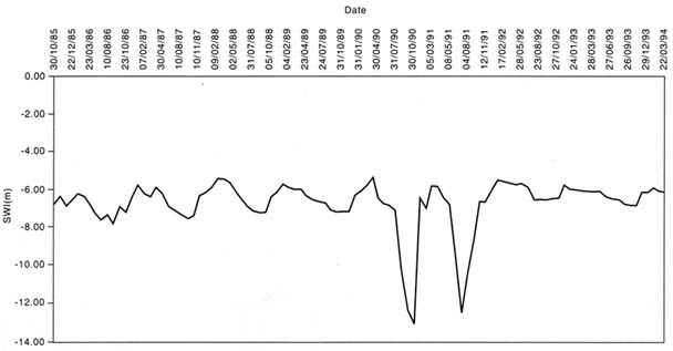
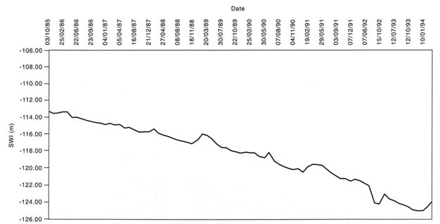
added to the aquifer is not enough to completely balance the amount discharged. The overall trend of the water level is downward, representing a continuing depletion of storage. Similar records are available for Israel and the West Bank and Gaza Strip.
As illustrated in Figures 2.5 and 2.6, the aquifers in the study area serve as reservoirs, allowing ground water to be used throughout the year and providing for drought protection. The total volume of freshwater contained in the area's aquifers is several billions of cubic meters. Although the depletion of ground-water storage has been only a small percentage of the total storage, it is indicative of an inherently unsustainable water supply. Ground-water pumping in the Gaza Strip, for example, exceeds recharge by about 2 to 18 million m3/yr; this excess pumping represents water that is permanently removed from storage in the underlying aquifer each year.
Over the past 10 years, the Disi aquifer in Jordan has been pumped at rates far exceeding its recharge rate, if it receives any recharge at all, resulting in a loss of storage expressed as a lowering of water levels by as much as 80 m. If rates of pumping continue to exceed the recharge rate, water level in the aquifer will ultimately decline below the depth at which they can be economically extracted. However, one justification for overpumping some aquifers for a short time is that it may permit development of a nonagricultural economy in a local area while transition is made to a genuinely sustainable economy in the future. Meanwhile, a nonsustainable agriculture is continued temporarily.
Of equal importance to water planners is the issue of drought contingencies. Although a drought year may severely affect the availability of surface water, it only affects the availability of ground water slightly, because of storage within the aquifers. Ground water is therefore likely to be overpumped during droughts to compensate for surface water deficiency. If the drought lasts for only one or two years, subsequent wetter years may largely replenish the losses in ground-water storage that result from the overpumping and diminished recharge during the drought. A series of drought years, however, may eventually lead to serious depletion of ground-water storage, with consequences for both short- and long-term water supply. Because of the uncertainty of future droughts, and the unknown effect on water supply caused by possible climate change, it is important to consider the probability and effect of drought years. Techniques such as optimization and simulation modeling can be used to prioritize the allocation of sustainable water resources for a variety of drought scenarios.
Surface Water
Estimated average annual surface water flow in the study area is about 1,429 million m3/yr. This figure is based on an average annual estimated flow of 1,300 million m3/yr in the Jordan Basin (CES Consulting Engineers and GTZ, 1996, p. 2-3), 47 million m3/yr in interior basins in Jordan (Salameh and Bannayan, 1993), 80 million m3/yr in coastal basins in Israel (Table 5.1 in CES Consulting Engineers and GTZ, 1996), and 2 million/m3/yr in the Gaza Strip (Palestinian Water Authority, written communication). Rates of streamflow in the study area vary significantly from year to year; in drought years, annual streamflow in the Jordan Basin may be as low as 420 million m3/yr and during wet years it may be as high as 2,460 million m3/yr (Table 2.2 in CES Consulting Engineers, 1996). Within-year fluctuations are also pronounced, with highest flows coinciding with the October to May rainy season.
Streamflow has two components: base flow and stormwater runoff. Ground water that discharges as springs or that seeps directly into streambeds constitutes the base flow or "fair weather" portion of streamflow, and accounts for virtually all the flow during the annual dry season. Perennial streams, that is, streams with a base flow component, exist only in the northwestern part of the study area, where ground-water recharge rates, and consequently ground-water discharge rates, are highest. These perennial streams include the Yarmouk River and the Upper Jordan River and its tributaries, such as the Dan River. As noted earlier, some formerly perennial streams, such as the Yarkon River on the coastal plain, no longer flow during the summer, owing to decreased natural ground-water discharge from the pumping of wells. This elimination of spring flow was planned, as part of a strategy to develop the water resource efficiently. However, instream use of perennial streams by native flora and fauna is an important and often overlooked benefit; the loss or reduction of perennial streamflow has had a profound effect on local biodiversity.
Because of the sensitivity of the base flow component of streamflow to ground-water withdrawals, surface water flow (1,429 million m3/yr) and ground-water recharge rate (1,534 million m3/yr) are not additive. This fact should be a significant consideration in water planning, particularly in the northwestern watersheds, which are the source of water transferred to the more arid southern areas via the National Water Carrier and the King Abdullah Canal. Surface- and ground-water supplies must be developed together, and not as separate resources. Unfortunately, studies to quantify the base flow component of streamflow in a consistent manner throughout the study area are lacking. As a result, efforts to define the availability of water accurately and to predict the consequences of withdrawals are somewhat hampered.
Stormwater runoff, or flood flow, is the other source of water in streams. The streams draining the northwestern part of the study area, where precipitation exceeds 500 mm/yr carry most of the annual stormwater runoff. Because the frequency, magnitude, and distribution of storm runoff are highly variable, and because many of the wadis tributary to the Rift Valley and elsewhere in the study area are not gauged, the quantity of stormwater runoff is not precisely known.
Except for very wet years, about half of the runoff in the relatively humid northwestern part of the study area is held behind impoundments and eventually utilized for water supplies. An estimated 100 million m3/yr of runoff occurs in unregulated streams and wadis. Additional development of this stormwater runoff is discussed in the section on Water Harvesting in Chapter 5. Unlike base flow, stormwater runoff has probably increased through human activities, because runoff rates are generally higher from paved areas and rooftops than from natural surfaces. The concentration of stormwater in urban areas provides a particularly favorable opportunity for the development of additional sources of water.
Some floodwaters naturally recharge underlying aquifers, particularly in the wadis tributary to the Rift Valley, and so they cannot be considered a source of supply completely above and beyond the associated ground water. More significantly, the widespread occurrence of stormwater in hundreds of small streams and wadis, together with the variability of stormwater from year to year, makes it impractical to construct impoundments that can trap all the flow. Additionally, elimination of storm flow will have adverse ecological effects on downstream waters and adjacent ecosystems.
Because of the temporal variability of surface water, this water source requires storage to increase its usefulness as a water supply. Lake Kinneret/Lake Tiberias/Sea of Galilee, a natural lake, is now highly managed to utilize the flows of the upper Jordan River drainage basin. Also, several dams have been constructed on west-flowing tributaries of the lower Jordan River, the largest of which is the King Talal Dam on the Zarqa River. The Yarmouk River, although not impounded, is diverted, partly into Lake Kinneret/Lake Tiberias/Sea of Galilee and partly into the King Abdullah Canal. Surface water management of the Jordan River watershed through impoundments and diversions provides almost one third of the water used in the study area. As a result of this management, average flow of the lower Jordan River has decreased from almost 1,400 million m3/yr to less than 300 million m3/yr (Salameh and Bannayan, 1993). The water remaining in the river is return flow from irrigated fields, the discharge of saline springs, and in wetter years, stormwater runoff.
On one hand, the decrease in the flow of the lower Jordan River can be regarded as a positive result of upstream water supply development, including 620 million m3/yr contributed to the National Water Carrier and 120 million m3/yr to the King Abdullah Canal. Additional water is also withdrawn from the Yarmouk River in Syria. On the other hand, the decreased flow and the poor quality of the remaining flow have had strongly negative effects on natural flora and fauna in the lower Jordan River, and have lowered water levels in the Dead Sea.
Other Sources of Water
Humans have greatly affected the natural hydrologic cycle in other ways. Withdrawal of water has altered streamflow and spring discharge and impaired water quality. A unique feature of the study area is the degree to which used water ("wastewater") is recycled and used again. Water supplies in the study area are supplemented by the use of 272 million m3/yr of reclaimed urban wastewater in the agricultural sector. A major concern in reusing wastewater is, of course, water quality. The present and potential use of wastewater as a water supply is discussed in the section on wastewater reclamation in Chapter 5.
In some cases, aquifers below the zone of active ground-water circulation may contain freshwater in what are referred to as "fossil" or "nonrenewable" aquifers. Because these aquifers receive little or no recharge, they cannot be said to have a sustainable yield. Nevertheless, they hold billions of cubic meters of usable water. It is estimated that about 95 million m3/yr of nonrenewable water are withdrawn from fossil aquifers in the study area. The consequences of this approach are discussed under the section on ground-water overdraft in Chapter 5.
Human activity can also create "new" freshwater through artificial desalination of water with excess salinity. This source is currently negligible within the study area, but its potential is discussed in a following section in Chapter 5 on desalination of brackish water. Another source of water is importation from outside the study area. This practice is not presently used in the study area, but some potential approaches are briefly described again in Chapter 5, in the section on imports of freshwater into the study area. Water importation has also been the object of analysis in recent planning reports, such as Biswas et al. (1997).
Water Quality and Salinity
One requirement of a sustainable water supply is that the biological, chemical, and physical characteristics of this water be suitable for its intended use. Characteristics that render a water source unsuitable for a use
may be natural, such as high salinity in some springs, or they may be introduced by human activities, such as toxic chemicals discharged to a natural water body. Treatment can, of course, turn any source into a suitable water supply, with desalination of seawater being an extreme example. Polluters rarely pay the cost of cleanup; rather, these costs usually reflect inefficiency and are borne by downstream users, or, as is commonly the case with ground-water pollution, by a future generation of users. The costs of treating water impaired by human activity therefore raise issues of both economic efficiency and intra- and intergenerational equity.
The chemical quality of ground water is determined by the nature of the rocks through which it moves. Some aquifers are composed of rocks, such as limestone, that are easily dissolved. Ground water moving through them, then, contains relatively large amounts of dissolved solids. Other aquifers are composed of relatively insoluble rocks, such as sand or sandstone, and these contain water with low dissolved solids. Human activities in recharge areas also greatly affect ground-water quality. Fertilizers, insecticides, leachate from landfills, and domestic and industrial wastes, for example, can contaminate aquifers.
Ground-water contamination by human activities at or near the land surface has only been recognized in recent years. Before about 1980, in some quarters it was believed that soils served as filters, preventing harmful substances deposited at the surface from migrating downward into ground water. Today it is known that soils and other intervening layers have a finite capacity to filter and retard substances and to protect aquifers from contamination (NRC, 1993). Because of the slow rates, and sometimes circuitous directions, of ground-water movement, remedial actions may be difficult or impossible. Protection of ground-water quality is therefore a prime consideration in the sustainability of the water supply.
Aquifers below the circulation zone generally contain brackish or saline water. Aquifers adjacent to seawater also contain saline and brackish water. Withdrawal of fresh ground water can induce the movement of brackish or saline water into freshwater parts of aquifers. Saltwater contamination is difficult to reverse and therefore also affects sustainability.
The chemical quality of surface water is determined by the quality of its two components: base flow and stormwater runoff. Ground water discharging into streams is at the end of a sometimes lengthy flow path and may contain relatively high concentrations of dissolved solids. The material dissolved in base flow generally consists of natural substances derived from the rocks that make up the aquifer, such as calcium, magnesium, sulfate, bicarbonate, and iron. Stormwater runoff generally contains
low concentrations of these substances, because it has limited contact with rocks containing them. Stormwater, however, often contains a high sediment load and, particularly when generated over urban or agricultural areas, may contain high concentrations of nitrates, phosphorus and other nutrients, as well as metals and organic material from fertilizers, pesticides, animal wastes, and trash.
Surface water generally requires more treatment prior to human consumption than does ground water. However, in the natural environment, plants and animals are in contact with untreated surface water, which often contains urban, agricultural, or industrial contaminants. Even relatively low concentrations of some of these contaminants in surface water can stress the biological integrity of lakes, reservoirs, and other receiving waters through various physical and chemical processes. Metals can be toxic to aquatic life and are often accumulated and concentrated in the food chain. Excess nutrients commonly result in the growth of undesirable aquatic plants and contribute to eutrophication. Suspended material in water causes turbidity, which affects light penetration and inhibits the growth of desirable aquatic plants. Biodegradable organic material (as measured by biochemical and chemical oxygen demand) can reduce the level of oxygen dissolved in water, killing fish.
An intrinsic problem of water management in arid areas is salinity. Salts are continually added to soils through water dissolution of rocks and minerals and degradation by plant roots (for example, the salt calcium carbonate), input of aerosols and recharge (for example, the salt sodium chloride), as well as by anthropogenic activity (for example, various salts of nitrogen and phosphorus as a result of fertilizer use). Where rainfall is sufficient, such salination is balanced by salts leaching out of the soil by infiltrating water (recharge). The salts are incorporated in groundwater and eventually discharged to streams or directly to the ocean, seas, or other terminal discharge points. In this way, humid areas are net exporters of salts and salt accumulation in soils is virtually nonexistent.
Arid regions, on the other hand, are generally net importers of salts, and salt accumulates in soils. Within the study area, experience has shown that salt accumulates in soils where annual precipitation is less than about 300 mm. Where precipitation is higher than about 400 mm, winter rains are effective in leaching out salts that have accumulated in the root zone during the previous summer. From the mean annual precipitation shown in Figure 2.3, it can be seen that only a very small part of the study area is able to sustain long-term agriculture without a management scheme that artificially removes salt accumulated in the soil.
Even within the humid parts of the study area where precipitation exceeds 400 mm/yr, the natural seasonal balance of salt accumulation
and releaching has been disturbed by human activity. Unlike precipitation, which contains very low concentrations of salts, irrigation with surface and ground water adds considerable salts to the soil zone. Even more salts are added when the source of irrigation water is recycled agricultural and municipal wastewater.
To recycle as much water as possible, drainage from agricultural lands is often recaptured and reused for irrigation. The use of this water, enriched in salts, can lead to serious problems of soil salination, as has occurred in the J'esreel Valley in Israel after about 20 years of such practice. Reuse of municipal wastewater is another serious source of salinity. Through water softening, food processing, use of detergents, and physiological sources, urban wastewater is enriched with salts. For example, an excess of 100 to 200 milligrams per litter (mg/l) of chloride is contained in wastewater in Israel when compared to the source water. Most treated wastewater in the study area has a dissolved solids content of more than 1,000 mg/l. The use of such water for irrigation has led to crop damage and reduced yields and may eventually lead to irreparable soil salination.
Both percolation of saline irrigation water and the leaching of salt by natural recharge lead to increases in dissolved solids in underlying ground water. These trends have occurred along the Mediterranean coast in Israel and the Gaza Strip, in the Jordan Valley and the Dhuleil area east of Amman, and elsewhere. The withdrawal of this enriched water for irrigation or domestic use (with ensuing treatment and reuse for irrigation) creates a cycle of increasing salination of both soil and ground water. Furthermore, the almost total elimination of natural ground water and surface water discharge effectively blocks the natural discharge of salts, so that the study area is now importing salts but not exporting them. The salts leached by winter rains from irrigated soils above the coastal aquifer accumulate in ground water at a rate of 2 mg/l chloride per year. While chloride concentration in ground water was 110 mg/l in 1963, it was 170 mg/l in 1993. Similar increases in chlorine contamination have been seen elsewhere in the study area.
One lesson from the area's history of soil and ground water salination is that total utilization of water, when coupled with significant internal recycling of water through reuse, is not sustainable because of progressive salt accumulation. A sustainable water management system should include salt removal, by natural leaching, removal of salty drainage water, or desalination.
Available Water in the Area
In the context of sustainability, the simplest definition of ''available" water is the average quantity of water available on a renewable basis. The
TABLE 2.2 Estimated Annual Average Renewable Surface- and Ground-Water Resources (in million m3/yr)
|
Source of Data |
Surface Water Resources |
Ground Water Resources |
Total Renewable Resources |
|
Multilateral Working Group |
1,200 |
1,400 |
2,600 |
|
This NRC Committee Report |
1,429 |
1,359 |
2,788 |
|
SOURCE: Multilateral Working Group data from CES Consulting Engineers and GTZ, 1996, p. S-3. |
|||
average annual rates of ground-water recharge (1,534 million m3/yr) and surface water flow (1,429 million m3/yr) are renewable resources. Unfortunately, these two water sources together cannot provide the total annual renewable water resources of the study area. As already noted, water moves from aquifers to streams (as base flow) and also from streams to aquifers (as recharge of stormwater runoff). An apparent attempt to reconcile all these factors has been made by the Multilateral Working Group on Water Resources (CES Consulting Engineers and GTZ, 1996). Although their definitions and methods are unclear, they estimate that annual average renewable water resources in the study area are 2,600 million m3/yr, consisting of 1,400 million m3/yr of ground water and 1,200 million m3/yr of surface water (Table 2.2). It is not clear how the 175 million m3/yr of ground water that discharge into the upper Jordan River and Lake Kinneret/Lake Tiberias/Sea of Galilee (Table 2.2 in CES Engineers and GTZ, 1996) are accounted for. An alternate calculation of renewable water resources, recognizing that there may be differences in accuracy of field data, would be to subtract the 175 million m3/yr from the total annual ground-water recharge (estimated in this report to be 1,534 million m3/yr), because it is eventually accounted for (and used for water supply) as surface water. This calculation yields an annual average renewable water resource of 2,788 million m3/yr (Table 2.2). Development of the total renewable resource, whether 2,600 million m3/yr or 2,788 million m3/yr, would be highly impractical because of the difficulties inherent in capturing all the storm flows.
The large amount of water stored in aquifers that could provide supplies in excess of natural replenishment is not considered in the above estimates of available water resources. Although short-term use of such storage to moderate the temporal variation in recharge is a standard water management practice, long-term and continual use of storage, or ground-water mining, would seem to be inherently a nonsustainable development. Use of fossil ground water is also nonsustainable, and this
resource is therefore not included in estimates of renewable water as well. However, it is estimated that 95 million m3/yr of nonrenewable fossil water is being used annually in the study area (25 million m3/yr in Israel and 70 million m3/yr in Jordan), and the Multilateral Working Group on Water Resources (CES Consulting Engineers and GTZ, 1996, p. 2-7) includes as much as 253 million m3/yr of fossil water (110 million m3/yr west of the Rift Valley, and 143 million m3/yr east of it) in their future water supply scenario. Social and economic issues of intergenerational equity, brought about, for example, by increased water use in new economic development, clearly need to be addressed before the fossil supplies are depleted. Hydrologic issues concerning the amount of stored ground water that can be pumped and other consequences of that pumping also need to be addressed.
Additional brackish ground water and nonconventional sources of water, such as wastewater reuse, desalination, and imports, are also available in addition to the renewable water resources. Although about 290 million m3/yr of brackish water are included in the renewable sources, hydrologic studies are needed to determine whether this or greater quantities of brackish water can be developed without significant deterioration of resource quality. The use of brackish water, primarily for industry and agriculture, is further addressed below in the section on use of water of marginal quality in Chapter 5.
At the present time, only wastewater is a significant nonconventional source of water in the study area. About 309 million m3/yr of wastewater are currently used in the area, 250 million m3/yr in Israel and 59 million m3/yr in Jordan. Opportunities to use greater amounts of wastewater are discussed in a following section on wastewater reclamation in Chapter 5. As much as 1,794 million m3/yr of area wastewater may be available for reuse in the future (Tables 5.1 and 5.2 in CES Consulting Engineers, 1996). Such large-scale use of recycled wastewater may lead to significant salination of soils and groundwater, as previously described.
Efficient use of the available water requires a high degree of planning and management, which is made more difficult by political considerations. For example, agreements between Israel and Jordan on the allocation of water from the lower Yarmouk River (Appendix A) are based on anticipated conditions of flow in the river. Average flow conditions, however, have changed in the past and may change again in the future: average annual flow between 1927 and 1964 was 467 million m3/yr; between 1950 and 1976, 400 million m3/yr; and for the most recent period about 360 million m3/yr (Salameh, 1996, p. 16). In addition to possible climatic changes, decreased flow in the Yarmouk River is attributable to upstream riparian use of surface water as well as groundwater withdrawals. Because much of this upstream use is in Syria, which is not a party to the
Israel-Jordan agreements, future availability of water from the Yarmouk is uncertain. In general, the use of transboundary water sources is subject to political considerations, but hydrologic and environmental considerations are more likely to lead to sustainable use (e.g., Feitelson and Haddad, 1995).
Another example of hydrologic uncertainty owing to political considerations is presented by the so-called mountain aquifer, underlying both Israel and the West Bank. Indiscriminate ground-water development in such cases, on either side of any future political boundaries, may result in significant depletion of this resource. To maximize the sustainable yield of this aquifer, the location of wells must be determined by hydrologic, not political, considerations. Options for the joint management of aquifers shared by Israelis and Palestinians are presented in Feitelson and Haddad (1995).
Planning and management of surface and ground water are also made difficult by inconsistent data. As pointed out earlier, it has been difficult to obtain hydrologic data collected and analyzed in a common and consistent manner, or other such study area data for hydrologic syntheses (CES Consulting Engineers and GTZ, 1996). Allocation of surface water (for example, from the Yarmouk River) or development of a shared aquifer (for example, the mountain aquifer) will be facilitated if all parties use common methods to collect and analyze pertinent data, and if all parties have access to these data. In recognition of this, the Multilateral Working Group on Water Resources implemented a Water Data Banks Plan in 1995 to work toward common methods of collecting water data in the study area. Also needed, however, are joint study teams to provide regionally consistent meteorological and hydrological analyses, if the water resources of the study area and the consequences of various water development scenarios are to be fully assessed.
Water Use
The total water used in the study area in 1994 was estimated to be 3,183 million m3/yr. Table 2.3 shows the breakdown by type of use (domestic, agricultural, and industrial) and by water source (ground water, surface water, and treated wastewater). From these data it can be seen that agriculture is the principal user of water, accounting for 66 percent of total use; about 62 percent in Israel, 64 percent in the West Bank and Gaza Strip, and 73 percent in Jordan. Excluding wastewater, agriculture accounts for 63 percent of the total surface-and ground-water withdrawals in the study area, 58 percent of withdrawals west of the Rift Valley and 72 percent east of the valley. Efforts to reduce the amount of freshwater used in the agricultural sector have been an important part of
TABLE 2.3 Estimated 1994 Water Use in the Study Area, by Subarea, Type of Use, and Water Source (in million m3/yr, except per capita use in m3/yr)
|
Type of Use |
Israel |
West Bank and Gaza Strip |
Jordan |
Total |
|
Domestic |
||||
|
Ground Water |
—a |
85 |
208 |
—a |
|
Surface Water |
—a |
0 |
33 |
—a |
|
Wastewater |
0 |
0 |
0 |
0 |
|
Subtotal |
545 |
85 |
241 |
859b |
|
Agriculture |
||||
|
Ground Water |
—a |
150 |
331 |
—a |
|
Surface Water |
—a |
0 |
382 |
—a |
|
Wastewater |
213 |
0 |
59 |
272 |
|
Subtotal |
1,180 |
150 |
772 |
2,102 |
|
Industry |
||||
|
Ground Water |
—a |
0 |
43 |
—a |
|
Surface Water |
—a |
0 |
0 |
—a |
|
Wastewater |
0 |
0 |
0 |
0 |
|
Subtotal |
129 |
0 |
43 |
172 |
|
Conveyance Lossesc |
50 |
— |
— |
50 |
|
Total Water Use |
||||
|
Ground Water |
1,006 |
235 |
582 |
1,811b |
|
Surface Water |
685 |
0 |
415 |
1,100 |
|
Wastewater |
213 |
0 |
59 |
272 |
|
Total |
1,904 |
235 |
1,056 |
3,183b |
|
Gross Water Use Per Capita |
344 |
93 |
244 |
257 |
|
a Because both ground water and surface water are conveyed in the Israeli National Water Carrier and distributed to domestic, agricultural, and industrial users, the precise sources of these supplies cannot be determined. b This figure is adjusted to eliminate the double counting of about 7 million m3/yr supplied to East Jerusalem and 5 million m3/yr supplied to the Gaza Strip by Israel and included in both the Israeli and the West Bank and Gaza Strip totals. c Conveyance losses are reported only for the National Water Carrier in Israel. Other service distribution systems, such as the King Abdullah Canal in Jordan and all piped distribution systems, have losses that are included in the water-use figures. SOURCE: Adapted from CES Consulting Engineers and GTZ, 1966. |
||||
water planning in the area, and have included, in addition to conservation measures, increased use of treated wastewater and brackish ground water. As a result of the increasing use of treated wastewater as a source of irrigation supply, the percentage of surface- and ground-water withdrawals used by agriculture has decreased from an estimated 80 percent in 1965 to the current 63 percent (Table 2.3). Further reductions in agricultural water use are discussed in the section on options for the future in Chapter 5.
There is significant disparity in water use among Israel, the West Bank and Gaza Strip, and Jordan, particularly in per capita domestic water use. Average per capita use of water in the domestic sector, based on population data from Table 2.1 and use data from Table 2.3, is 98 m3/yr in Israel, 34 m3/yr in the West Bank and Gaza Strip, and 56 m3/yr in Jordan. These per capita figures reflect water put into urban distribution networks; as much as half this water may be lost due to leaky pipes in some systems. As previously discussed, moves toward economic parity will tend to increase water consumption; one planning scenario projects future per capita domestic use of water at 90 m3/yr in Israel and 70 m3/yr in Jordan and the West Bank and Gaza Strip (CES Consulting Engineers and GTZ, 1996, p. 3-11).
The heavy reliance on ground water in the study area is apparent from Table 2.3. Ground water accounts for 57 percent of total water used and 62 percent of water withdrawn. Current total ground-water withdrawals of 1,811 million m3/yr (Table 2.3) are in excess of the estimated 1,359 to 1,400 million m3/yr of renewable ground-water resources (Table 2.2). The "overpumping" of between 411 and 452 million m3/yr consists of 95 million m3/yr of fresh fossil water (25 million m3/yr in Israel and 70 million m3/yr in Jordan), 81 million m3/yr of brackish fossil water in Israel (Table 2.4 in CES Consulting Engineers and GTZ, 1996), with the remainder, about 250 million m3/yr, taken from storage, most of it from aquifers in Jordan. The total overpumping in Jordan may be as much as 307 million m3/yr of renewable water.
In contrast to ground water, Tables 2.2 and 2.3 together indicate a surplus of between 100 and 329 million m3/yr of surface water. This surplus largely represents uncaptured stormwater runoff in the wadis tributary to the Jordan Rift Valley. According to various studies, more than 200 million m3/yr of stormwater runoff may currently be captured by retention structures throughout the study area (BRL-ANTEA, 1995; and Water Authority of Jordan 1996, open files). The possible use of stormwater to augment existing water supplies is discussed under watershed management in Chapter 5.
The Importance of Hydrologic Relationships in the Study Area
In reviewing information on the study area, the committee was struck by the absence of a consistent, comprehensive, and reliable body of data on the availability and use of water resources. This lack is attributable to three different problems. First, the reliability of some data is open to question. There is no agreement, for example, about the quantities of surface water available for diversion in an average year. Second, some important measurements are either incomplete or absent altogether. For example, there is no comprehensive characterization of the temporal variation in precipitation and runoff. Finally, data are sometimes gathered on different and incommensurate bases, leading to difficulties in characterizing the water-related features of the study area.
The committee notes that, regardless of national boundaries, the waters of the area are shared because the region is hydrologically connected. Changes in the quantities and qualities of water available in one area will have impacts on the quantities and qualities available in other areas. So long as political or other non-hydrologically based jurisdictions are used as the fundamental planning units, important hydrologic relationships are likely to be ignored in planning, to the detriment of some or all of the inhabitants of the region. The only way to ensure that these important relationships are revealed directly and explicitly is to take a regional hydrologic viewpoint in water resources planning.
Clearly, a comprehensive hydrologic data base is needed to inform and support water resources planning in the region. This need is being partially addressed by the Water Data Banks Project of the Multilateral Working Group on Water Resources of the Middle East Process, and may be further addressed by the Joint Water Committees formed as part of the Treaty of Peace between Israel and Jordan (Appendix A) and the Israeli-Palestinian Interim Agreement on the West Bank and Gaza Strip (Appendix B). Developing such a data base will require the commitment of significant human and financial resources. Thus, for these as well as scientific reasons, it is important that the data be developed consistently and that the same measurement techniques be used throughout the study area. The need for comprehensive, consistent data for planning strengthens the case for viewing the water resources of the study area regionally.
Optimal water resources planning can only be accomplished if the study area itself is taken as the basic physical management unit. Failure to plan on a regional basis and to account for important hydrologic relationships will undoubtedly destroy important opportunities to economize on water use, take advantage of joint and conjunctive uses, manage waters of different quality best, and allocate between instream and consumptive
uses optimally. In addition, as discussed in Chapter 4, cooperative water resources planning will be important to ensure that the value of ecosystem goods and services is realized.
Recommendations
The committee recommends that responsible national and international agencies should take a regional approach to achieve several critical ends:
- Acquire data on water availability and uses employing consistent methodologies, techniques, and protocols.
- Monitor both quantitative and qualitative conditions of area water resources using consistent techniques and units of measurement.
- Encourage an open exchange of scientific research results relevant to the area's water resources and encourage relevant scientific research on a regional and collaborative basis.
References
Al-Weshah, R. A. 1992. Jordan's water resources: Technical perspective. Water International 17(3)September:124-132.
BRL-ANTEA. 1995. Guidelines for a Master Plan for Water Management in the Jordan River Basin. Ingenierie, France: BRL. Not published.
Biswas, A. K., J. Kolars, M. Murakami, J. Waterbury, and A. Wolf. 1997. Core and Periphery: A Comprehensive Approach to Middle Eastern Water. Middle East Water Commission. Delhi: Oxford University Press.
CES Consulting Engineers and GTZ. 1996. Middle East Regional Study on Water Supply and Demand Development, Phase I, Regional Overview. Sponsored by the Government of the Federal Republic of Germany for the Multilateral Working Group on Water Resources. Eschborn, Germany: Association for Technical Cooperation (GTZ).
Cohen, S., and G. Stanhill. 1996. Contemporary climate change in the Jordan Valley. J. Applied Meteor. 35:1052-1058.
Feitelson, E., and M. Haddad. 1995. Joint Management of Shared Aquifers: Final Report. Jerusalem, Israel: The Palestine Consultancy Group and the Harry S Truman Research Institute. 36 pp.
National Research Council. 1993. Ground Water Vulnerability Assessment, Contamination Potential Under Conditions of Uncertainty. Washington, DC: National Academy Press. 204 pp.
Principal Organization of Soviet Ministers for Geology and Cartography. 1988. Geographical Belts and Zonal Types of Landshafts (in Russian) 1:15,000,000. Moscow.
Salameh, E. 1996. Water Quality Degradation in Jordan. Amman, Jordan: Friedrich Ebert Stiftung and Royal Society for the Conservation of Nature. 179 pp.
Salameh, E., and H. Bannayan. 1993. Water Resources of Jordan: Present Status and Future Potentials. Amman, Jordan: Friedrich Ebert Stiftung and Royal Society for the Conservation of Nature. 183 pp.
Stanhill, G., and C. Rapaport. 1988. Temporal and spatial variation in the volume of rain falling annually in Israel. Isr. J. Earth Sci. 37: 211-221.
U.S. Central Intelligence Agency. 1993. Atlas of the Middle East. Washington, DC: U.S. Government Printing Office.
Water Authority of Jordan. 1996. The Water Authority of Jordan Annual Report . Amman, Jordan. In Arabic.


