
Page 48
5
Climate-System Components
The climate attributes that influence society, as noted earlier, are themselves influenced by a broad range of physical and biogeochemical processes, or components (including forcings) of our climate system. Therefore, to improve our understanding of how changes in these attributes manifest themselves over decade-to-century time scales, we must address the issues involving those components that will most efficiently advance this understanding.
While the existence of climate patterns offers hope that some fraction of the variability in the climate attributes may be related to the state of these patterns, ultimately we must understand the physics that control both the evolution of the climate system and the patterns themselves. A relationship between climate patterns and climate attributes may afford us some statistical forecasting capabilities, but only of configurations or types of changes already documented. Forecasting future variations demands that we understand the physical and biogeochemical interactions controlling climate response and feedbacks, and identify the slow components of the system in which predictability resides.
This chapter briefly describes our current understanding of how physics and biogeochemistry influence climate, particularly the six climate attributes outlined in Chapter 2, and presents the primary issues that must be resolved to advance most expeditiously and cost-effectively our understanding of climate change and variability on dec-cen time scales. The six sections of this chapter present the components and forcings of the climate system in discipline-based discussions. This division is somewhat arbitrary, since dec-cen-scale change and variability in the atmosphere involve considerable couplings with and feedbacks from the oceans, land, and cryosphere. Consequently, the study of dec-cen change and variability entails multi- and interdisciplinary issues, and highly coupled systems. Past study of climate and its components has generally proceeded along disciplinary boundaries, however, and the funding sources for such study have been similarly partitioned. Much as we would have liked to have organized this chapter into the new cross-disciplinary structures that will ultimately be needed for future advances in dec-cen climate research, it proved quite difficult to determine an ideal, or even acceptable, cross-disciplinary structure that would conveniently present the multitude of issues, both disciplinary and cross-disciplinary, in a logical progression. We have chosen instead to indicate by cross-referencing the relationships that may guide future cross-disciplinary organizational structures.
This chapter begins with an overview of the atmospheric composition and radiative forcing, which is fundamental to externally forced (natural and anthropogenic) variability and change. External forcing of the climate system, while not properly a component of climate, is included here. Because this document articulates a plan for addressing the science of dec-cen climate change and variability, external forcing must be included for completeness, and to provide the necessary foundation for subsequent discussion in the report. Given the thoroughness of the topic's coverage in the IPCC assessment process, and the accessibility of the IPCC reports, we do not attempt to replicate that review. Rather, we draw from it and build on it in order to provide an overview of the atmospheric composition and radiative forcing most relevant to dec-cen climate issues.
The remaining sections of this chapter focus on five distinct components of the climate system. The first two, which are closely related, involve two aspects of the atmosphere: atmospheric circulation and the hydrologic cycle. (Of course, the latter section's scope involves more than just the atmosphere, since it discusses the storage of water and its movement through the atmosphere and boundaries.) These two sections are followed by the three atmospheric boundary components from which most internal dec-cen variability originates: the oceans, the cryosphere, and land and vegetation. Interdisciplinary aspects of the components' interactions are presented throughout the sections when appropriate, and several of the broader crosscutting issues that defy traditional disciplinary categorization are presented in Chapter 6.
Page 49
In each of the six sections of this chapter, the discussion is partitioned into subsections dealing with the influence of the particular climate-system component on climate attributes, the evidence of variability and change of that component on dec-cen time scales, and the mechanisms through which that component operates within the climate system. At the end of each section there is a discussion of the principal outstanding issues associated with that climate-system component, as well as an overview of some of the key observational and modeling priorities that will help resolve the outstanding issues. The discussion of the requisite observational and modeling strategies is not intended to be comprehensive; rather, it provides a broad perspective on the types of research initiatives that are most likely to be productive.
Finally, we wish to emphasize that this chapter deals with all the components of the climate system that influence dec-cen variability, whether that variability be natural, anthropogenically induced, or anthropogenically modified natural.
Atmospheric Composition and Radiative Forcing
Changes in solar output—either in terms of total radiative flux (the solar constant), or in terms of the spectral distribution of this radiation—will directly influence the radiative environment and energy budget at the Earth's surface, the response of the climate system, and the response of many life forms. Moreover, changes in the atmospheric concentration of a number of trace constituents directly influence the transfer of radiative energy throughout the atmospheric column, and therefore the energy balance in the atmosphere, including the temperature at the Earth's surface. Such direct climate influences are modified by myriad feedbacks that indirectly affect surface temperatures and radiative fluxes, the hydrologic cycle, storm frequency and intensity, sea level, and ecosystem structure and functioning. Increasing the skill with which such feedbacks can be quantified is a principal challenge for earth system science over the next decade.
The primary reason for the current widespread concern about global climate change is that human activities are increasing the greenhouse effect of the atmosphere and the tropospheric aerosol burden, and weakening the stratospheric ozone shield against ultraviolet radiation. Greenhouse gases (e.g., H2O, CO2, CH4, N2O, chlorofluorocarbons, and O3 in the troposphere) warm the Earth' s surface by trapping a portion of the outgoing longwave-radiation flux. Atmospheric aerosols tend to cause surface cooling by scattering solar radiation back into space (although they can produce the opposite effect if they consist of very dark material or if they are over a bright surface such as snow or ice), and they exert indirect effects by providing nucleation sites for the formation of cloud droplets. The net influence of the myriad feedbacks responding to changes in atmospheric gas and aerosol content has yet to be determined. Better understanding of these climatic influences will be fundamental to our ability to predict the nature and magnitude of the climate' s response to anthropogenic change in any of the forcing factors.
Radiative forcing is affected not only by anthropogenic changes, but also by natural variations in the sun's output and by the input and distribution of volcanic aerosols. Largely unpredictable, these elements exert measurable influence over the Earth's radiative budget and atmospheric chemical interactions, and account for some of the natural dec-cen variability in the Earth's climate. Solar output, volcanic aerosol contributions, and atmospheric gases and aerosols thus represent the main forcings, natural and anthropogenic, of the climate system. In this respect, they are distinct from the components of the climate system discussed in the other sections of this chapter, and changes in them will drive responses in those other components. Ultimately we need to be able to differentiate climate variations driven by changes in the forcings (internal or external) from variations that are the expression of internal or coupled modes of variability, which will occur even when forcing is steady. Our efforts to understand the behavior of climate variations may be furthered by the fact that the forcings and responses may vary with latitude or regional characteristics, possibly relating specific forcings to specific responses or climatic fingerprints. For example, the stratospheric warming by volcanic aerosols in the Northern Hemisphere winter is greater in low latitudes than in high latitudes (Labitzke and Naujokat, 1983; Labitzke and McCormick, 1992). The differential heating produces a larger pole-to-equator temperature gradient, which in turn increases the zonal winds and enhances the stratospheric polar vortex. The stronger polar vortex may affect the vertically propagating tropospheric planetary waves, and so modify the tropospheric circulation and alter surface air temperature (Mao and Robock, 1998). Thus, radiative influences associated with aerosols may differ from those driven by other types of radiative forcing in the high latitudes.
Influence on Attributes
The solar radiation striking the Earth, however it may be modified by the atmosphere's components, fundamentally mediates the Earth's energy budget and climate through a complex array of feedbacks. In the process, it influences all of the climate attributes discussed in Chapter 2. These feedbacks include changing the atmospheric concentration of water vapor, itself the major greenhouse gas; changing cloudiness; changing the surface albedo due to changes in snow, ice, and vegetative cover; changing source and sink rates for carbon dioxide, methane, and nitrous oxide; changing the formation rates for tropospheric ozone and aerosols; and changing the transport and storage of heat in the oceans. Each of these feedbacks further influences the surface temperature and radiative fields, which in turn alter the evaporation of water from, and precipitation onto, land and water
Page 50
surfaces, as well as the water balance of glaciers, ice caps, and snow fields. Soil moisture and runoff are affected, influencing the water quality and quantity of surface waters and the salinity of surface layers of the ocean. Sea level responds to the heat content of the oceans and the distribution of heat in the oceans, as well as reflecting the proportion of the Earth's total water mass that resides in the oceans. Changes in the radiation budget also affect ocean transport and storage of heat and carbon, further modifying surface temperatures and the hydrologic cycle. Changes in energy and water fluxes may also alter the pattern or strength of pressure systems in the atmosphere, thereby modifying the tracks, intensity, and frequency of storms.
Ecosystems are influenced by changes in radiation through a variety of related processes and reactions. For example, ozone is important to ecosystems and society, in part, because it filters UV-B radiation, as mentioned in Chapter 2. Ozone depletion increases the surface flux of UV-B, which increases health and ecosystem risks. Increased UV-B has been explicitly linked to damage to marine phytoplankton (Smith, 1995), which form the base of the marine trophic system and organic carbon cycle. Industrial and natural aerosols in the lower troposphere reduce the quality of the air we breathe, increasing risks to human health and to ecosystems. Changes in atmospheric carbon dioxide directly influence vegetation through both fertilization and changes in response to water stress. A number of chemical feedbacks associated with changes in aerosol and ozone levels can affect ecosystems. For example, tropospheric ozone controls the oxidizing capacity of the troposphere and its ability to remove other pollutants. It has also been implicated in reduced crop growth (see, e.g., Reich and Amundson, 1985).
Evidence of Decade-to-Century-Scale Variability and Change
External forcings of the climate system, in a number of cases, vary on dec-cen time scales. Some of these forcings are the result of human activities (e.g., emissions of chlorofluorocarbons), some are natural in origin (e.g., solar variability), and some are both anthropogenic and natural (e.g., aerosols). The primary types of radiative forcing exhibiting dec-cen variability are outlined below; each of these three classes is represented.
Greenhouse Gases
Carbon dioxide is the most important of the greenhouse gases emitted as a result of our activities. Not only is it responsible for a little over half of the current direct anthropogenic greenhouse forcing (IPCC, 1995) but its long atmospheric residence time assures that any enhancement of atmospheric concentration will persist for many centuries. Methane, which is the second greatest contributor to direct anthropogenic greenhouse forcing, is characterized by shorter residence times, but more rapid growth in atmospheric concentration than CO2 (IPCC, 1995). The increases in atmospheric carbon dioxide and methane over the last thousand years, as measured from ice cores and directly in the atmosphere, are depicted in Figure 5-1. The relative constancy of both gases until the turn of the twentieth century indicates that their natural variability in the atmosphere has been relatively small over the last millennium. During the last glacial maximum (about 18,000 BP) CO2 and CH4 were respectively about 70 percent and 45 percent of the more recent pre-industrial levels (Barnola et al., 1987; Jouzel et al., 1993; Nakazawa et al., 1993; Chappellaz et al., 1993a). Extensive analyses of sources and sinks for both of these gases (e.g., Wigley and Schimel, 1994; IPCC, 1995), leave no doubt that their steep rises during the latter part of this century, coinciding with the human population explosion, is the result of human activities. The rate of CO2 emissions from fossil-fuel burning has increased approximately 250 percent in the past 30 years (Figure 5-2, upper curve). Although the net global CO2 uptake rate exhibits substantial interannual variability in response to climatic variations (Figure 5-2, lower curve), it has generally increased as the concentration of atmospheric CO2 has risen (Figure 5-1, solid curve). Atmospheric methane's rate of growth varies substantially from year to year, but that rate has generally been decreasing over the last two decades (Figure 5-3), for reasons that are not entirely clear.
Evidence from ice cores indicates a strong coupling between global surface temperature and the concentration of atmospheric methane since at least 40,000 BP (Chappellaz et al., 1993a; Severinghaus et al., 1998). It is believed that
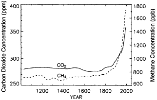
Figure 5-1
Atmospheric carbon dioxide and methane during the last 1,000 years.
CO2 (solid curve) refers to the vertical scale on the left; CH4 (dashed
curve) refers to the scale on the right. The CO2 curve is based on long
-term CO2 data from Etheridge et al. (1996) and modem CO2 data from
Conway et al. (1994). The CH4 curve is based on long-term CH4 data
from Blunier et al. (1993) and Nakazawa et al. (1993), and more recent
CH4 data from Dlugokencky et al. (1994) and Etheridge et al. (1992). (Figure
courtesy of P. Tans, NOAA/CMDL.)
Page 51
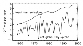
Figure 5-2
The upper curve represents the rate of CO2 emissions from fossil-fuel burning
(Marland et al., 1994). The lower curve represents the net global uptake rate of
CO2 by the oceans and the terrestrial biosphere. This uptake rate was derived
using the assumption that the Mauna Loa CO2 record is representative of the
atmosphere as a whole. The difference between the lower and upper curves is
the rate of atmospheric CO2 increase (corrected for the seasonal cycle). (Figure
courtesy of P. Tans, NOAA/CMDL.)
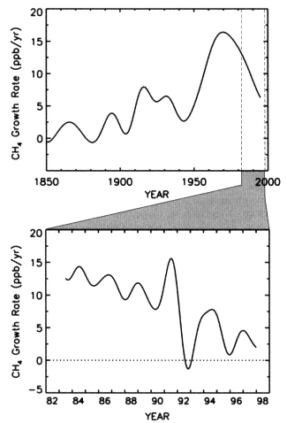
Figure 5-3
The rate of increase of atmospheric methane over the last 150 years.
Based on data from Etheridge et al. (1996) and Dlugokencky et
al. (1994). (Upper panel courtesy of P. Tans, NOAA/CMDL; lower courtesy
of E. Dlugokensky, NOAA/ CMDL.)
the changes in methane may have been responding, at least in part, to changes in soil moisture and wetland extent (which partially control methane emissions), driven by re-organizations of the climate system. Although the precise nature of the mechanisms that have caused temperature and methane to co-vary in the past are somewhat uncertain, these paleorecords indicate the possibility that temperature and methane may also co-vary in response to future climate changes.
Changes in tropospheric ozone, a third greenhouse gas, are not well documented. We have a limited number of discontinuous surface records that indicate tropospheric ozone may have doubled since the 1950s or at least since the nineteenth century (Figure 5-4). The data on free tropospheric ozone that are available from selected sites since 1970 show no consistent trends, however.
Stratospheric Ozone
One of the best-known changes in atmospheric composition observed over the last several decades is the dramatic
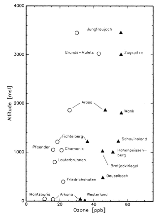
Figure 5-4
Measurements of surface ozone from different locations in Europe showing
increasing concentrations from before the end of the 1950s (circles) to 1990-1991
(triangles) during August and September, as a function of altitude. (From
Staehelin et al., 1994; reprinted with permission of Elsevier Science.)
Page 52
decrease in stratospheric ozone over Antarctica. The comparison of the annual cycle in column ozone between Arctic (Resolute) and Antarctic (Halley Bay) locations is shown in Figure 5-5. Measurements in Antarctica between 1956 and 1965 showed a difference of 200 Dobson units (one DU equals 10-2 mm·atmosphere of column ozone) between Arctic and Antarctic springtime values (Dobson, 1966). This difference is due to the differing meteorologies of the two regions, particularly the isolation of the Antarctic vortex much later in the spring. More recent measurements, made at Halley Bay by the British Antarctic Survey, demonstrate an additional 200 DU deficit, commonly called the Antarctic ''ozone hole.'' This dramatic decrease in Antarctic stratospheric ozone has been a regular feature since 1989; it represents a major decadal change in our planet. In the past few boreal springs, significant decreases in Arctic ozone have been noted as well (NOAA, 1995, 1996, 1997). Although these Arctic levels have generally not been much lower than typical tropical values (~250 DU), they do constitute a significant anomaly for that region.
Evidence of stratospheric ozone depletion over dec-cen time scales is also indicated in other records. Figure 5-6
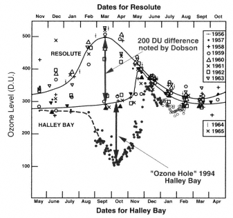
Figure 5-5
Annual cycle of column ozone from the Arctic (Resolute) and Antarctic (Halley Bay)
for 1956-1965 and 1994. The top and middle curves are smoothed representations of
the Arctic and Antarctic data, respectively. The points towards the bottom of the figure
illustrate the magnitude of the ozone "hole" at Halley Bay in 1994. Units are Dobson
units (DU). The Southern Hemisphere time scale (bottom axis) has been shifted by 6
months to line up with that of the Northern Hemisphere (top axis). (Figure courtesy of
R. Stolarski. Halley Bay data from J.D. Shanklin of the British Antarctic Survey.
After Dobson, 1966; reprinted with permission of the Royal Meteorological Society.)
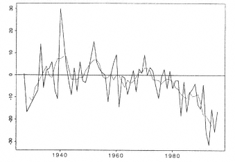
Figure 5-6
Anomalies from 1926-1996 of total ozone measured over Arosa, Switzerland,
relative the 1926-1969 mean of 339 DU. The dotted line shows the 5-year moving
average and the solid line shows the annual mean. The downward trend since
1978 averaged 1.12% per decade. (From Staehelin et al., 1998; reprinted with permission
of the American Geophysical Union.)
shows annually-averaged deviations in ozone over Arosa, Switzerland, since the 1930s; a decline over the last two decades is apparent. Losses of total ozone (i.e., the mass of ozone vertically integrated through the entire atmosphere) have been greatest in the higher latitudes, with very little change in the tropics (WMO, 1995).
The eruption of Mt. Pinatubo in June of 1991 provided a nearly hundred-fold increase in the surface area available for heterogeneous chemical processing in the stratosphere. Observations following the eruption indicated significant reductions in NO2 (Johnston et al., 1992; Koike et al., 1994) along with increased concentrations of HNO3 (Rinsland et al., 1994). These changes suggest that reactive nitrogen species (e.g., NO2) were repartitioned into less reactive forms, which in turn helped to temporarily enhance the levels of active, ozone-depleting chlorine radicals (e.g., ClO) relative to those of the more inert chlorine reservoirs (e.g., HCl). Although the predicted massive ozone loss in the volcanic cloud did not occur (Prather, 1992), observations at that time showed evidence of greater ozone depletion than that expected in response to the continued growth in stratospheric chlorine abundance (Hofmann et al., 1994; Komhyr et al., 1993). A 6-8 percent loss of ozone in the tropics immediately after the eruption is more likely to have been associated with the vertical lofting that accompanied the strong stratospheric heating by the aerosols (Kinne et al., 1992). Overall, observations by the Total Ozone Mapping Spectrometer (TOMS) showed an additional global ozone deficit of about 2-3 percent by mid- 1992 that might be attributed to Mt. Pinatubo (Gleason et al., 1993). The atmosphere had mostly returned to normal a couple of years after the volcanic perturbation, and it is difficult to determine how much of
Page 53
the ozone depletion in these years should be attributed to chlorine increases and how much to volcanic aerosols.
The decrease in polar stratospheric-ozone concentrations that has been documented over the past 30 years is strongly related, at least in part, to the increase in atmospheric chlorine (Figures 5-7 and 5-8). While levels of chlorinated compounds in the atmosphere are still high, their growth rates tend to be decreasing, and in some cases are negative.
Aerosols
Volcanic aerosols can have a significant influence on the radiative balance (defined as the difference between absorbed solar radiation and outgoing longwave radiation) of both the stratosphere and the Earth's climate system. For instance, Labitzke et al. (1983) showed that the aerosols produced by the eruption of El Chichón, which achieved a peak concentration at 24 km between about 10ºS and 30ºN (for
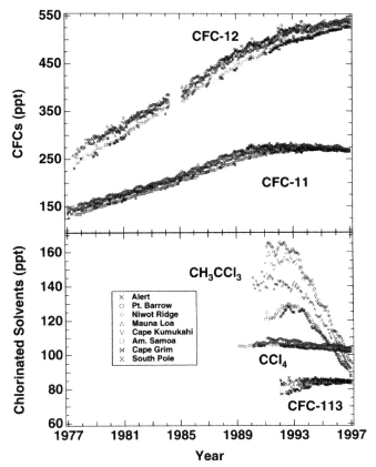
Figure 5-7
Atmospheric trends of chlorinated compounds controlled under the Montreal
Protocol from 1977 to 1995. The mixing ratios from surface measurements are
reported as monthly means in parts per trillion (ppt) in dry air. CFC-11 and CFC-
12 data are updated from Elkins et al. (1993); methyl chloroform (CH3CCl3),
carbon tetrachloride (CCl4), and CFC-113 (CCl3F-CClF3) data are updated from Montzka
et al. (1996). (Figure courtesy of NOAA/CMDL.)
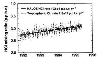
Figure 5-8
Stratospheric trend of HCl from 1991 to 1995. HALOE is the Halogen Occultation
Experiment. (From Russell et al., 1996; reprinted with permission of Macmillan Magazines, Ltd.)
the first six months), warmed this region of the atmosphere by a few degrees. Following the eruption of Mt. Pinatubo, substantial changes to the planetary albedo were observed (Minnis et al., 1993). In addition, substantial heating in the tropical stratosphere was observed immediately after Pinatubo's eruption. This heating was sufficient to cause tropical stratospheric temperatures at 30 hPa to increase as much as three standard deviations above the 26-year mean (Labitzke and McCormick, 1992). On the other hand, global surface temperature was also observed to decrease in the months following the Pinatubo eruption as a result of the increased planetary albedo (see, e.g., Dutton and Christy, 1992), and the temperature remained suppressed through 1993, as predicted (Hansen et al., 1996).
In addition to these radiative effects of volcanic aerosol, recent work by Solomon et al. (1996) demonstrates that the observed aerosol variability can influence the modeled ozone trends. Periods of peak aerosol loading appear to correlate better with additional ozone depletion than with a trend fitted to the dominant driving force in ozone depletion, stratospheric chlorine levels. It is difficult to interpret this trend in ozone over the 15 years of TOMS data without including the concurrent variations in stratospheric aerosols.
Since the late 1970s, near-global monitoring of stratospheric aerosol distribution has been carried out by in situ (Wilson et al., 1992), ground-based (e.g., Osborn et al., 1995), and satellite-based instrumentation (SAM II and SAGE measurements; see, e.g., Thomason et al., 1997b). Over this period, the primary source of stratospheric aerosol variability has been periodic injections of aerosol, or of gaseous aerosol precursors such as SO2, by volcanic eruptions. In general, stratospheric aerosols are produced in situ by processes that include the photochemical transformation of gaseous SO2 into H2SO4 aerosol. For example, the composite SAM II/SAGE/SAGE II record of stratospheric-aerosol optical depth shows large effects from the eruptions of El
Page 54
Chichón in 1982 and Mount Pinatubo in 1991, as well as effects of several smaller eruptions such as Mount St. Helens in 1980, Nevada del Ruiz in 1985, and Kelut in 1990 (McCormick et al., 1993). The eruption of Mt. Pinatubo may have caused the largest perturbation to stratospheric aerosol loading of any eruption since Krakatau in 1883.
The meridional distribution and the residence time of volcanic aerosols are strongly dictated by the latitude of the eruption, the altitude reached by the eruption plume, time of year, and phase of the quasi-biennial oscillation at the time of the initial aerosol injection (Trepte et al., 1993). As a result, any reconstructions of stratospheric aerosol loading resulting from volcanic eruptions are subject to significant uncertainties if they are extended backwards before the start of global measurements in 1978 (see, e.g., Sato et al., 1993), since many of the aforementioned parameters are poorly known. Additional indications of aerosol concentrations over longer time periods can be obtained from the longer records of Sato et al. (1993) (Figure 5-9) and from ice-core analyses (e.g., those of Zielinski et al., 1994). It has been suggested that the non-volcanic background stratospheric aerosol mass has increased by 5 percent annually over the period from 1978 to 1989 (Hofmann, 1990), though SAGE-based evaluations tend to argue against this increase (Thomason et al., 1997a).
Solar Radiation
The sun is the driving force of climate; even small variations in the amount of energy that the Earth receives can apparently have significant impact (for instance, see the last section in this chapter for a discussion of the role of solar
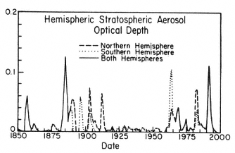
Figure 5-9
Stratospheric aerosols as a function of time. For the period 1883-1990, aerosol
optical depths are estimated from optical extinction data, whose quality increases
with time over that period. For the period 1850-1882, aerosol optical depths are
more crudely estimated from volcanological evidence for the volume of ejecta from
major known volcanoes. (From Sato et al., 1993; reprinted with permission of the
American Geophysical Union.)
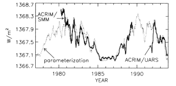
Figure 5-10
Total solar irradiance from 1975-1995 measured by the Active Cavity Radiometer Irradiance
Monitor/Solar Maximum Mission and Upper Atmosphere Research Satellite (ACRIM/SMM
and ACRIM/UARS). The dotted line is a model of the total irradiance variability obtained
from a parameterization of the influence of sunspot darkening and facular brightening, which
are recognized as the two primary mechanisms of irradiance variability during the 11-year
solar cycle. (After Lean et al., 1995; reprinted with permission of the American Geophysical Union.)
variations in the waxing and waning of the great ice ages). By comparison, a doubling of CO2 in the atmosphere would generate a radiative forcing equivalent to a 1.8 percent increase in solar irradiance. Best estimates derived from solar proxies suggest dec-cen changes in solar irradiance on the order of 0.25 percent over the past 400 years (Nesme-Ribes et al., 1993; Lean et al., 1995; Hoyt and Schatten, 1993). However, the only direct record of solar-irradiance variability we have covers only the last one and one-half solar cycles; as Figure 5-10 illustrates, the recent range of variations is about 0.1 percent. The total-irradiance record shown in Figure 5-10 is based on satellite observations, and involves a modeled reconstruction over this period. (It has long been known from indirect measures of solar radiation that the variability of the sun's UV radiation has an 11-year period.)
Although UV radiation constitutes only a small portion of the total solar irradiance, it is more variable by at least an order of magnitude than the visible-radiation portion, and therefore contributes significantly to total solar variability. This UV variability has special relevance to chemical interactions in the upper atmosphere, where the temperature structure depends partly on the absorption of UV radiation by O3, O2, N2, and other gases. This relationship was highlighted by Hood and McCormack (1992), who showed a strong correlation between O3 and UV radiation on the 11-year solar cycle.
Additional records of the sun's activity are derived from observations, beginning early in the seventeenth century, of the occurrence of dark spots on the face of the sun; they are not a direct measurement of solar irradiance, but over the period for which we have direct irradiance measures, high sunspot activity correlates strongly with increased irradiance.
Page 55
Sunspots are associated with bright faculae that surround the dark spot. Although the spots themselves are areas of decreased irradiance, the faculae are longer-lived and more areally extensive, leading to an overall increase in total irradiance at times of sunspot maxima. Sunspot observations indicate that solar activity has varied on an 11-year cycle for the past 300 years (since about AD 1690). But longer-term variation has been inferred from observations of sunspots made over the last several centuries. For instance, during the Maunder Minimum (1650-1690) no sunspots were observed (Lean, 1991). Longer- and shorter-period variance also occurs. The sunspot record exhibits an 80-100 year period known as the Gleissberg cycle, and the apparent alternation of stronger and weaker 11-year cycles produces a concentration of variance with a 22-year period. Over shorter periods, the sun exhibits variations associated with its rotation (which has a 27-day period), and monthly and yearly variations are seen within the envelope of the 11-year activity cycle.
Indirect indicators of solar activity, such as sunspots and the abundance of cosmogenic nuclides (e.g.,14C and10Be), have considerably longer records than direct observations. Figure 5-11 shows two different indices that are commonly used to infer some measure of solar activity (e.g., solar wind), and are known to correlate with irradiance over the last solar cycle (see, e.g., Wilson and Hudson, 1991). These longer, proxy records show distinct long-term shifts in solar activity over the past several centuries; for example, such shifts can be seen in the record of10Be found in ice cores. Production of10Be by galactic cosmic-ray particles in the Earth's atmosphere is modulated by the solar wind; this long-lived radionuclide is removed from the atmosphere by precipitation and preserved in ice cores. Ice-care10Be abundances were significantly higher in the fifteenth and late seventeenth centu-
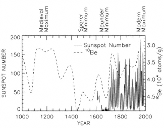
Figure 5-11
Time series of sunspot number and
10Be in ice cores, which are both known to
correlate with irradiance over the past few solar cycles. (After Beer et al., 1988; reprinted
with permission of Macmillan Magazines, Ltd.)
ries, implying that the solar wind was much weaker then than it is today. The relationship between solar wind and solar irradiance has been calibrated for the last two solar cycles; the extrapolation for conditions outside the range of direct observations of total solar irradiance—if applicable—implies a dec-cen solar irradiance variation with periods in which irradiance may be lower by as much as 0.25 percent.
Mechanisms
The sun's radiation, volcanic eruptions, and human emissions of greenhouse gases and aerosols are sources of variability and change that are external to the climate system. Except for the sunspot cycle, they are not predictable at this time. A number of internal and coupled modes of variability within the climate system, however, influence concentrations of trace gases and aerosols in the Earth's atmosphere. Understanding the mechanisms and forcings behind these modes of variability will enhance our ability to predict climate variations.
Greenhouse Gases and the Carbon Cycle
The major externally forced causes of the observed CO2 increase are the burning of fossil fuels (Marland et al., 1994) and forest destruction (Houghton et al., 1987). Internally, carbon is transferred relatively rapidly among three major "mobile" reservoirs—the oceans, the atmosphere, and the biosphere. About one-seventh of the atmospheric CO2 enters the oceans each year, and half as much is fixed into organic material by photosynthesis on land. These fluxes are almost balanced by the amounts leaving the oceans or returned to the atmosphere through microbial decay, respectively. We know that more CO2 is entering these reservoirs than leaving, however, because the rate of atmospheric increase is only about half as large as the global production of CO2 through the combustion of fossil fuels. From year to year imbalances manifest themselves in interannual variations of the rate at which atmospheric CO2 increases; the swings of net global CO2 uptake shown in Figure 5-2 are related to known climate variations such as El Niño. Several studies have found correlations on different time scales between the rate of atmospheric CO2 increase and global average temperature, as well as ENSO indicators (Elliot et al., 1991; Dai and Fung, 1993; Keeling et a1., 1995).
Although carbon dioxide cycles quickly among the mobile reservoirs, it leaves the ocean-atmosphere system only very slowly, through the burial of organic matter and deposition of carbonate rocks. Dissolution of calcite, also a very slow process, adds carbon to the mobile reservoirs, but increases the carbon-holding capacity of the oceans even more by changing their alkalinity. Therefore, the rates at which future anthropogenic CO2 is removed from the atmosphere will depend mostly on how the additional carbon from fossil-fuel burning is partitioned between the mobile reservoirs,
Page 56
which can essentially be considered to constitute a closed system. Thus, the important factors controlling increases in atmospheric CO2 concentrations are: first, the rate of fossil-fuel consumption; second, the circulation of the ocean and, to a lesser extent, how the circulation affects marine biological productivity; third, management of the land; and fourth, carbon storage by ecosystems, possibly stimulated by increased CO2 and anthropogenic deposition of nitrogen. Climate change will affect all of these natural processes.
The magnitude of the ocean's role in the partitioning of CO2 is dependent on the ocean's chemical capacity to take up CO2. This capacity is determined by the amounts of carbonate and borate ions, which can be "titrated" by newly dissolved CO2 into bicarbonate and boric acid, respectively. It takes many centuries for most of this capacity to be accessible to the atmosphere, however, because the ocean turns over very slowly. The ocean's pH could be lowered by a full point if "all" (defined as 400×1015 mol) fossil-fuel carbon were burned (Tans, 1998). (Since the pre-industrial era, we have consumed about 5 percent of that amount.) These estimates are based on the assumption that the ocean's "biological pump'' keeps operating as it does today. This pump represents the photosynthesis in the sunlit surface layer of the ocean and the sinking of organic particles that keeps the carbon content and CO2 partial pressure lower in surface waters than in the deep oceans. Without any ocean biology, the partial pressure of CO2 in the atmosphere would be two to three times higher than it is today (Najjar, 1992). At low and temperate latitudes almost all the available phosphate and nitrate are consumed, but this process is only partially effective at high latitudes. Changes in the effectiveness of the biological pump at high latitudes, which result from changes in the balance between the rates of thermohaline overturning and the rates of biological production, have been invoked in attempts to explain the atmospheric CO2 concentration differences between glacial and interglacial periods (see, e.g., Knox and McElroy, 1984, and Sarmiento and Toggweiler, 1984).
The "solubility pump" is another process by which the ocean maintains a vertical gradient of carbon. Because deep-water formation sites are cold and the solubility of CO2 is inversely related to temperature, water with a high inorganic carbon content is "pumped" to the deep oceans at deep-water formation sites. A vertical CO2 gradient is thereby produced between the deep water and the warmer, overlying waters of the remainder of the ocean' s surface. The strength of the solubility pump is affected by changes in alkalinity, air-sea gas contrast, and ocean temperature. Without the solubility and biological pumps, the concentration of atmospheric CO2 would be three to four times higher than it is today (Najjar, 1992).
The carbon delivered to the deep ocean by these pumps is exchanged with that in the atmosphere on time scales of centuries and longer. The strengths of both pumps may change with changes in mixed-layer characteristics and upwelling. The latter will alter both the nutrient supply and the time available for surface phytoplankton to utilize these nutrients, as well as affecting the surface temperature, mixed-layer thickness, and air-sea gas contrast.
Deforestation—which before 1940 or so occurred principally in temperate latitudes, but more recently has been taking place mostly in the tropics—has long been considered a large source of atmospheric CO2 (Houghton et al., 1987). In the global balance, tropical deforestation is compensated for through increased net uptake by terrestrial ecosystems, principally at temperate latitudes (Tans et al., 1990; Wofsy et al., 1993; Ciais et al., 1995; Battle et al., 1996). Even in the tropics there could be large areas of net CO2 uptake (Grace et al., 1995). Possible explanations for the observed uptake are fertilization of plants by higher atmospheric CO2 levels (see, e.g., Mooney et al., 1991) and fertilization by atmospheric nitrogen deposition (see, e.g., Schindler and Bailey, 1993, and Townsend et al., 1996). An additional complication in the internal and coupled mechanisms that produce variations in the carbon cycle is the fact that the balance between source and sink may shift as climate changes (Dai and Fung, 1993), which may account for some increase in terrestrial CO2 uptake. For example, there is some evidence that the Arctic tundra, once a net sink for atmospheric CO2, may have turned into a source during the last decades as a result of Arctic warming (Oechel et al., 1993). These results still need to be confirmed by data from additional sampling sites.
Unlike long-lived CO2, methane has an atmospheric lifetime of about 10 years. The increasing atmospheric methane burden reflects the growth of CH4 sources in recent decades, with about 60 to 80 percent of this increase attributable to human activities (IPCC, 1996a). The increasing atmospheric concentration of methane directly affects the radiative balance and the chemistry of the troposphere; it accounts for approximately 20 percent of the increase in radiative forcing since the pre-industrial era (IPCC, 1995). In addition, it has an indirect effect on the stratosphere, because, once oxidized, it is an important source of stratospheric water vapor. The most important sources of atmospheric methane are wetlands, rice agriculture, cattle and sheep, biomass burning, fossil fuels, landfills and waste, and termites (see, e.g., Fung et al., 1991).
The atmospheric fate of methane is largely determined by the level of ultraviolet radiation in the troposphere and the concentrations of other key trace gases (e.g., ozone, water vapor, nitrogen oxides, carbon monoxide) responsible for the production and recycling of OH radicals, which in turn initiate the oxidation of methane. Perhaps somewhat surprisingly, no significant decadal trend in OH concentration itself has been detected, in that no change has been seen in the inferred atmospheric lifetime of the synthetic industrial compound chemical methylchloroform, which is also attacked by OH (Prinn et al., 1995). Accurate predictions of future CH4 levels need to take into account the effects of the relationships between CH4, CO, and OH (Prather, 1994).
Page 57
Changes in the concentrations of atmospheric chlorofluorocarbons and similar fully halogenated industrial compounds with no natural sources are controlled primarily by emissions. The lifetimes of the individual gases are determined by transport to and photolysis in the stratosphere. The loss of the equally long-lived nitrous oxide (N2O) is likewise limited by stratospheric chemistry, but its emissions come from a mix of both natural biogenic sources and anthropogenic perturbations to the nitrogen cycle. Both sets of gases build up in and decay from the atmosphere on a time scale of centuries. Ozone, on the other hand, is also an important greenhouse gas, but its atmospheric concentration is determined primarily by a balance between in situ production (mainly in the stratosphere) and photochemical losses that occur on a time scale of a year or less. The balance is tipped in favor of losses when chlorofluorocarbon (CFC) and N2O concentrations increase, because they catalyze ozone destruction in the stratosphere.
The source and sinks of anthropogenic radiatively active gases remain a primary concern in determining the extent of the effect of greenhouse gases on global climate. However, an equally important (yet poorly understood) influence on climate is the distribution of increased atmospheric water vapor associated with a speeding up of the hydrologic cycle (discussed in detail later). The atmospheric portion of the hydrologic cycle is complex, and operates on both short and long time scales. The fast processes associated with this mechanism, such as cloud formation and the related intra-and inter-cloud radiative impacts, influence cloud nucleation, longwave radiation, albedo feedbacks, and ultimately the surface energy balance. On dec-cen time scales, the impact of increased water vapor is realized through alterations in large-scale cloud distribution (shown earlier in Figure 2-12), which reflect both the water-vapor distribution and the hydrologic cycle's response. Also, the latent heating of clouds, and its radiative effects, influence the large-scale atmospheric circulation and hydrologic cycle—additional complexities that need to be better understood.
Stratospheric Ozone
Our understanding of the cause of the Antarctic ozone hole has grown considerably thanks to ground-based and aircraft campaigns, and, more recently, satellite missions. The evidence is clear: Observations of high levels of reactive chlorine species coincide with the observations of rapid ozone depletion. The only identified cause of this ozone depletion since the 1970s is the rise in stratospheric chlorine levels, which is driven by the increasing abundance of chlorofluorocarbons and other halocarbons in the lower atmosphere. Laboratory studies have identified and quantified the reactions of chlorine radicals that catalytically destroy ozone, and numerical models of the stratospheric circulation and chemistry predict similar losses. This loss in stratospheric ozone was likely responsible for the recent cooling of the lower stratosphere, and model results indicate that the ozone loss could be expected to have a general cooling effect on the climate (IPCC, 1995). An enhancement of stratospheric ozone destruction would reduce the stratospheric source of tropospheric ozone and increase the UV radiation that drives tropospheric photochemistry. Present models using the best laboratory physics and chemistry can simulate such ozone loss.
CFCs and related halocarbons have no known natural sources, and their atmospheric concentrations in 1950 were negligible. The much higher concentrations currently measured reflect a history in which halocarbons are emitted at the Earth's surface, propagate vertically through the troposphere, and, over the course of five years, ultimately reach the upper levels of the stratosphere. The rise in tropospheric chlorine loading from CFCs and related halocarbons is documented in Figure 5-7. (Note that the concentrations of all of these gases except CFC-12 have begun to fall since 1993, as a result of declining halocarbon emissions.) Upon reaching the stratosphere, these compounds dissociate and release chlorine, which in the upper stratosphere is predominantly in the form of HCl. Figure 5-8 shows the increase in stratospheric HCl observed by satellite during the early 1990s. The total content and magnitude match those of the tropospheric halocarbon sources (allowing for the 5-year lag). The recent decline in tropospheric chlorine should be visible in the HCl record over the next several years.
In addition to their effect on stratospheric ozone, CFCs are potent greenhouse gases; they have contributed to approximately one-quarter of the increase in greenhouse-gas radiative forcing over the past decade (11 percent of the total increase since pre-industrial times). The decline in radiative forcing that CFCs induce through stratospheric ozone depletion is likely somewhat less than their direct radiative contribution (IPCC, 1995).
Aerosols
Since 1978, a series of low-latitude, high-altitude injections of volcanic aerosols has maintained a maximum in aerosol loading in the tropics, centered at altitudes between 20 and 27 km. Although the primary controlling mechanism is external, there are internal mechanisms that serve to limit the spatial distribution and temporal longevity of these injected aerosols. For example, the latitudinal wind gradient in the subtropics impedes transport between the tropics and mid-latitudes. Thus, the maximum in aerosols following a large volcanic eruption in the tropics (e.g., Mt. Pinatubo or El Chichón) remains for a few years in the tropical stratosphere as a long-lived source of aerosol for the middle and high latitudes (Trepte and Hitchman, 1992; Thomason et al., 1997b). Non-volcanic sources of stratospheric aerosols, such as natural organic carbonyl sulfide (OCS) and industrially derived SO2, also tend to support the presence of a tropical aerosol.
Page 58
While explosive volcanic eruptions are the most significant source of stratospheric aerosols, a non-volcanic background level of stratospheric aerosols appears to be present. It has been suggested that this may result from the diffusion of tropospheric OCS into the stratosphere (Crutzen, 1976). However, recent research (Chin and Davis, 1995) suggests that OCS has likely produced only negligible amounts of the stratospheric aerosols observed since 1978. Hofmann (1990) has proposed that the possible 5 percent annual increase in the non-volcanic background stratospheric aerosol mass from 1978 to 1989 could be related to the increase in sulfur emissions from commercial aircraft or other anthropogenic sources.
Tropospheric aerosols also influence the overall surface radiative balance through their light-scattering and absorption properties. Tropospheric aerosols, being relatively short-lived in the atmosphere, show regional variability related to the distribution of their sources. Consequently, the non-uniform distribution of these aerosols yields spatially heterogeneous radiative forcing, even given a uniform greenhouse-gas (or natural) forcing. Examples of tropospheric aerosol sources and typical aerosol types are: deserts, which produce mineral dust; vegetation, which produces particulate organic carbon and sulfate aerosols; biomass burning, which produces soot; oceans, which produce sea salt; and industrial centers, which produce dust, soot, and sulfates. The characteristics of the Earth's surface play a role not only in determining the type of aerosols that are emitted, but in determining the dispersal of aerosols. For example, the wind friction caused by surface roughness, which is greatly influenced by the stature and density of the vegetation, affects turbulent mixing of air in the planetary boundary layer.
Depending on the absorption characteristics of a given aerosol, its effect on radiative forcing can be positive or negative. For instance, low-albedo soot aerosols produced from biomass and fossil-fuel burning tend to produce surface warming. However, higher-albedo sulfate and dust aerosols tend to produce surface cooling, and are believed to exceed the radiative influence of darker aerosols on a globally averaged basis by 0 to 1.5 W m-2 (IPCC, 1996a).
Predictability
Greenhouse Gases
The primary uncertainty regarding predictions of future warming associated with increased concentrations of greenhouse gases comes from uncertainties in the emission scenarios, as well as tremendous gaps in our understanding of, and ability to represent in models, the myriad feedback processes that may act to enhance or diminish any direct warming. One of the most important feedback processes is the interaction between atmospheric water vapor, clouds, and the surface radiation balance. The details of this complex interaction are still poorly understood. Until this understanding is improved, and better parameterizations constructed, a fundamental question regarding the impact of greenhouse gases cannot be adequately addressed.
A great variety of global carbon-cycle models have been used to estimate future burdens of atmospheric CO2 on the basis of projected rates of fossil-fuel combustion and associated greenhouse warming. Important model parameters are calibrated such that the past behavior of atmospheric CO2, radiocarbon (14C), and the13C/12C isotopic ratio are reasonably well reproduced. Representation of the processes responsible for the partitioning of carbon between the mobile reservoirs is often very crude, sometimes speculative, and involves many assumptions. These models are best viewed as extrapolative tools, and their predictive power beyond the next few decades is tenuous.
Prediction of future atmospheric methane concentrations depends primarily on prediction of the CH4 sources, and sec-ondarily on how the oxidative capability of the atmosphere evolves. The main sources of CH4 have been identified, but the range of uncertainty in emissions rate on regional and global scales is typically a factor of two or three for each source process.
Stratospheric Ozone
The year-to-year variations of stratospheric ozone at a given location are not yet predictable, and modulation of the depletion on 2- to-3-year periods by major volcanic eruptions (as observed) cannot be predicted. However, the decadal trend in ozone depletion can be predicted from the evolving load of stratospheric chlorine (e.g., Figure 5-7b) and bromine: The tropospheric abundance of their source gases is now declining for the first time, and we can expect stratospheric levels to follow in a few years.
While the behavior of the Antarctic ozone hole on a decadal time scale is fairly straightforward, it is predictable in the long term only if Antarctic meteorology remains more or less the same as today's. If it does, the ozone hole will persist until chlorine levels drop somewhere below about 2 ppb, which is expected to occur around 2050 at best if the phaseout of CFCs and related compounds is successful. This prediction is fairly certain, although the slow decay of CFCs and the degree to which the Montreal Protocol is followed makes the exact date at which we drop below the ozone-hole threshold uncertain within about 20 years. Fortunately, CFC and chlorine increases are very predictable, given the future releases of CFCs and related halocarbons.
Aerosols
Prediction of the long-term influence of tropospheric aerosols may be possible, but a better understanding will be needed of how the spatially heterogeneous, but semi-stationary, distribution of tropospheric aerosols influences the larger-scale climate response. The stratospheric effects of volcanic aerosols are necessarily unpredictable, however, because the occurrence and magnitude of eruptions are not
Page 59
currently predictable. Since the role of volcanic aerosols in ozone trends, and in climate in general, is complex (and aerosols may be more persistent than they have been thought to be), our current ability to produce global depictions of stratospheric aerosol loading (especially in terms of surface-area density) with high vertical resolution is essential. Satellite-based systems such as the EOS/SAGE III instrument will do this well, as long as suitable orbits and frequencies of launch are maintained. Corroborative efforts using ground-based and in situ systems will also be necessary to provide the high-quality data needed to understand the role of stratospheric aerosols in determining climate.
Solar Radiation
The predictability of this phenomenon is limited to empirical extrapolation of solar activity and irradiance. Probably the best prediction regarding solar activity is that the 11-year solar cycle will continue as recently recorded. Although we have observed the sun for only a tiny fraction of its lifetime, the sun is a fairly common type of star and we can derive certain inferences from observations of other similar stars. If observations of many sun-like stars represent comparable stars at different stages in their lifetime, then they can be used to infer the frequency of different behavioral modes. Moreover, these observations provide evidence for linkages among solar-activity proxies and total irradiance. Of sun-like stars with similar mass, radius, rotation rates, activity cycles, and emissions spectra, some 33 percent have no evidence of emission variability associated with sunspot (starspot) variability over a decade of observations. By implication, multidecadal inactive periods such as the seventeenth-century Maunder minimum may be rather common events. Yet our current understanding of solar physics does not enable us to predict between-cycle variability far in advance, much less these larger, multidecade-to-century-scale variations inferred from solar proxies and seen in sun-like stars.
Remaining Issues and Questions
Greenhouse Gases
• What changes in carbon storage and flux can be expected on dec-cen time scales, including responses to climate change? Of the carbon emitted by anthropogenic activities (burning of fossil fuels and deforestation) in the past two centuries, just over half has remained in the atmosphere. The carbon that has been removed from atmosphere has gone into the other "mobile reservoirs"—the biosphere and surface ocean. Although initial estimates of carbon sinks failed to account for a large portion of anthropogenic CO2 emissions, recent measurements suggest that an increase in the amount of carbon stored in the terrestrial biosphere may account for this "missing sink" (for a review of this topic, see Houghton et al., 1998, among others). Uncertainties in estimates of biospheric activity, coupled with a poor knowledge of the surface ocean's uptake and additional uncertainties regarding carbon's pathways and fate within the ocean and terrestrial reservoirs, make it likely that our knowledge of the fate of anthropogenic CO2 is not yet complete. Atmospheric CO2 has been increasing steadily since the mid-1800s, but interannual-to-decadal fluctuations in its rate of rise appear in the atmospheric record. These fluctuations may arise from biospheric or from oceanic variability. To predict atmospheric greenhouse-gas concentrations, we must reduce the uncertainties that surround current evaluations of carbon sources, sinks, and fluxes. We must also improve our understanding of how the uptake of each of the mobile reservoirs may vary with changing climate. This means understanding better the relationship between changes in the ocean's mixed layer and its impacts on the biological and solubility uptake of carbon by the ocean, and the response of land vegetation to climate change and its potential for producing methane and carbon dioxide. In the Arctic, the active layer of the soil and the upper permafrost contain approximately 300 gigatons (Gt) of carbon. In recent years, Arctic tundra ecosystems have switched from being a sink of a few tenths of a Gt of carbon per year to a source of a few tenths (Oechel et al., 1993). These recent losses, which clearly change in conjunction with climate, may now exceed 10 percent of the anthropogenic CO2 emissions. (Further discussions of the ocean and terrestrial uptakes of carbon appear in the "Cryosphere" and the ''Land and Vegetation" sections of Chapter 5.)
• What are the relative contributions of the various sources and sinks to the recent increase in methane? Although observations document an increase in atmospheric CH4 since the nineteenth century, the causes of this rise in a potent greenhouse gas remain poorly quantified. Methane sinks appear to be stable over at least the most recent decade, so the total source is well known from the atmospheric rise. However, the contribution of individual components remains poorly quantified. Sources likely to be increasing include agricultural wetlands and livestock herds, biomass burning, fossil-fuel-related industry, and landfills. Future changes in OH will influence the lifetime and atmospheric concentrations not only of methane, but of a number of other radiatively active constituents as well.
• How does the photochemical breakdown of methane contribute to other chemical and radiative processes in the atmosphere on the dec-cen time scale? The photochemical breakdown of CH4 consumes OH and produces H2O throughout the atmosphere. In the stratosphere, even small amounts of water vapor are extremely efficient contributors to the global greenhouse effect, accounting for nearly half of the radiative impact of water vapor in the atmosphere (the remainder comes from lower-tropospheric water vapor). Dec-cen changes in methane can be expected to alter the vertical distribution of water vapor in the upper troposphere and lower stratosphere, thereby changing radiative forcing.
Page 60
The actual contribution of water vapor from methane breakdown at the radiatively important altitudes is not known, however. The ice particles that form at these altitudes also provide sites for heterogeneous chemistry. The feedbacks among these chemical processes and atmospheric dynamics are largely unknown.
• Why is N2O increasing on dec-cen time scales? Records of atmospheric N2O (a greenhouse gas) show a steady rise since the nineteenth century, but a quantitative budget of N2O sources and sinks explaining this rise cannot be developed from the existing scarce observations and our limited understanding of the processes involved. The global N cycle has been heavily altered by human activities, particularly the widespread application of high-nitrate fertilizers (Melillo, 1995). Atmospheric N2O concentrations have been affected by anthropogenic changes in the nitrogen cycle (including industrial N2O production), and oceanic denitrification/nitrification rates have been affected by changes in near-shore productivity caused by increased nitrogen loading. The relative importance of the various components of the nitrogen cycle need to be better understood so that the specific causes of the observed rise in N2O can be deciphered, and so that our predictions of future N2O levels can be improved.
• Why has extratropical tropospheric ozone increased since the last century, and are further increases likely? Many questions exist in this area. For example, what are the relative importances of the processes known to affect tropospheric ozone? Are precursors, photochemistry, transport, and dilution important? How much is tropospheric ozone influenced by the growing emissions from aircraft and surface sources of NOx (i.e., nitrogen oxides with an odd number of oxygen molecules) and other species? Although its trend over recent decades is unclear, tropospheric ozone has almost certainly increased substantially since the last century. Because tropospheric ozone is not only a greenhouse gas and a UV shield, but a pollutant with documented health and ecosystem impacts, we need to be able to predict its concentration.
• What are the cloud-water-vapor-radiation processes and feedbacks that will strongly influence climatic response to increased radiative forcing? Much of the climate's response to an increase in greenhouse gases will ultimately be associated with the change in atmospheric water vapor, and its vertical distribution. Water vapor influences clouds (e.g., their formation and radiative properties), which in turn influence the surface radiation balance. Our present understanding of how water vapor, clouds, and radiation balance interact is poor; until this fundamental set of feedbacks is better known, one of the most basic questions regarding anthropogenically induced climate change cannot be properly addressed.
Stratospheric Ozone
• How does the coupling between chemistry, dynamics, and radiation in the lower stratosphere and upper troposphere operate on dec-cen time scales? For example, what do we need to know in order to predict accurately the timing of stratospheric ozone recovery from anthropogenic halo-carbon depletion? How and by what mechanisms do changes in the stratosphere affect atmospheric circulation and the surface radiation balance on longer time scales, recognizing that much of the lower-stratospheric influence is manifested through chemical and transport changes that originate over short time scales? Ozone distribution influences the vertical temperature structure and dynamics of the lower stratosphere because of its absorption of UV radiation. These dynamics determine the distribution of other atmospheric constituents (including ozone), and thus to some degree their chemical interactions, in the upper troposphere as well as the lower stratosphere. Human impacts on these coupled processes include a potential future fleet of high-flying aircraft and changes in the sources of ozone-destroying halogenated compounds. The long-term feedbacks among human influences, chemical interactions, and atmospheric dynamics are largely unknown and must be better understood.
Aerosols
• How do the spatial distribution, chemical composition, and physical properties of aerosols vary on dec-cen time scales, and how do they relate to climate variability? For example, how do the impacts of aerosols on the Earth's radiation budget vary by region? Although aerosols appear to constitute a critical radiative-forcing factor that is active on dec-cen time scales, the mechanisms and processes involved remain poorly characterized. Many of them appear to have short-time-scale influences with long-time-scale implications. (This is true for both tropospheric and stratospheric aerosols.) For example, the indirect effects of aerosols on cloud properties and formation, as well as on solar and thermal radiation, remain a major uncertainty—but may represent the primary impact of aerosols on climate. The direct radiative effect of absorbing aerosols (e.g., soot) in the atmosphere over high-albedo surfaces is hypothesized to lead to surface warming. Predicting future aerosol impacts on climate requires an understanding of regional sources and transports, and how those may vary under a given future climate scenario. Human-initiated changes (e.g., in industrial emissions, biomass burning, or land use) will be key to future aerosol variations; natural sources (e.g., volcanic eruptions and natural vegetation emissions) will contribute as well, and may be even less predictable. Our understanding of the influence of tropospheric aerosols on dec-cen climate-change problems is, in general, woefully inadequate, and requires considerable attention to identify the most important aspects.
Solar Radiation
• How do proxies for solar activity (e.g., sunspots or
Page 61
cosmogenic nuclides) relate to total solar irradiance on dec-cen time scales? Direct measurements of the sun's radiative output span only the last solar cycle. Solar radiation appears to correlate well with solar activity as represented by sunspot variations, solar wind intensity, and charged-particle fluxes. Reconstructions of solar activity that extend over nearly the past 400 years can be derived from records of cosmogenic nuclides (e.g.,10Be) and historical sunspot observations. Extrapolated from measured relationships over the past solar cycle, these reconstructions indicate variability in solar radiation of 0.25 percent over decades to centuries. The sensitivity of climate to solar variations has been explored using observational data and climate models, but it is still not clear how well the solar proxies represent irradiance. For example, when sunspot observations indicate no activity during the Maunder minimum (AD 1600-1640),10Be records continue to indicate relative changes. A better understanding of the sun's influence on dec-cen climate variability requires improving reconstructed solar irradiance.
• What feedbacks govern climate and ecosystem response to changes in solar UV on dec-cen time scales? Although the part of the solar spectrum likely to have greatest climatic influence lies in the visible range, the decadal solar variation observed over the last solar cycle occurred primarily in the UV range. Variations in UV have demonstrable effects on stratospheric O3 levels and on atmospheric electricity, which may influence cloud-droplet nucleation. UV variability may also influence temperature patterns in the middle atmosphere, which affects the surface climate by altering how planetary waves propagate energy. Although primary producers in both the marine and terrestrial realms can be affected, the impact of UV on ecosystems is poorly understood. The impact of UV radiation on the Earth's climate system on dec-cen time scales must be taken into account.
• To what extent are dec-cen climate changes, as observed in instrumental and paleoclimate records, related to changes in the sun's output, and what mechanisms are involved in the response of climate to changes in solar radiation? Decadal variations occur in most records of climate with sufficient length and resolution, but the degree to which these fluctuations can be attributed to solar variability is still being debated. Even studies that point to apparently distinct influences of solar variability on climate often indicate highly variable sensitivities for a given change in irradiance. Feedbacks in the climate system, particularly the atmosphere, may account for enhancement or damping of the climatic response to solar forcing. Understanding the sensitivity of the Earth's climate to past changes in solar activity will permit better predictions of future changes in the face of decadally varying solar irradiance. It will also suggest potential responses associated with other sources of change in the radiative forcing (e.g., internal sources, such as changing albedo).
Observations
Resolution of many of the key issues defined here will require data from observing systems that do not yet exist, or to which no long-term commitment has yet been made. For example, current data on solar irradiance come from short-term satellite missions that have no operational (long-term) mandate. Measurements from different missions are significantly offset from one another in terms of accuracy (NRC, 1994). Similarly, planned satellite measurements are capable of detecting the presence of tropospheric aerosols, but they will not assess the properties of aerosols with the accuracy required for full understanding of their potential climatic effects. Addressing issues related to dec-cen solar variability (above) requires a plan for long-term, calibrated solar-irradiance measurements across the solar spectrum. Even the broad-band shortwave radiation at the Earth's surface must be measured with considerably greater precision; the Atmospheric Radiation Measurement (ARM) program measures shortwave radiation to no better than 50-60 W m-2, whereas precisions of 10-20 W m-2 are the minimum acceptable.
Resolving carbon-cycle issues will require a CO2 measurement strategy that accounts for the hierarchy of scales, both temporal and spatial, inherent in ecosystem processes and their controls. We need atmospheric concentration data that allow us to improve our ability to identify and quantify regional sources and sinks, and to assess the response of these sources and sinks to climate fluctuations and human perturbations. These data will provide the information necessary to regionally integrate the carbon fluxes and feedback processes that can be measured, understood, and modeled on smaller spatial and temporal scales. Isotopic data allow distinction between oceanic and biospheric sinks, on regional scales and have provided significant insight into the regional carbon balance (e.g., Tans et al., 1993; Ciais et al., 1995). Measurements of O2/N2 ratios in the global atmosphere provide an independent constraint on the balance between net terrestrial and oceanic sinks (Keeling et al., 1996b). The scaling and measurement issues for N2O and CH4 are almost identical, and their biogeochemical budgets could be tackled together with a measurement program suitable for CO2.
An intermediate-scale observation system that would be crucial for estimating the CO2 budget also holds the key to quantifying the sources of CH4 on regional scales, especially if full use can be made of isotopic-ratio data. The improved understanding of CH4 dynamics that would arise from this type of enhanced quantification would probably help predict future CH4 levels.
Enormous progress in establishing trace-gas budgets could be achieved if a refined method of directly measuring air-sea gas-exchange rates could be developed. Promising candidate methods are air measurements with eddy correlation (e.g., Baldocchi et al., 1996) and/or eddy accumulation (e.g., Businger and Oncley, 1990). Such measurements would eventually yield a more realistic understanding of the
Page 62
processes controlling the rate of air-sea gas exchange, and permit the development of a parameterization that could be applied with confidence worldwide. These improvements would make it possible to utilize the existing climatologies of the partial-pressure differences between air and water for many gases to derive better maps of gas exchange (see, e.g., Takahashi et al., 1997). Oceanic CO2 partial-pressure data would then become a much more compelling constraint on the atmospheric budget, and the ''open top" of surface-ocean gas budgets could be closed.
Processes and Parameterizations
A number of processes that operate predominantly on short time scales need to be better understood and parameterized in order to properly evaluate their role in dec-cen climate variability and change. For example, how do the composition and properties of aerosols determine both their direct and indirect radiative effects? How do tropospheric aerosols contribute to climate change on long time scales? How do aerosols contribute to cloud formation, precipitation, and radiative interaction? Cloud processes in general and their relationship to atmospheric water vapor and the radiation balance, although they occur on time scales far shorter than decadal, remain a major uncertainty in the prediction of future radiation balances; parameterizations need to be improved for cloud formation and distribution as a function of water-vapor distribution, surface boundary conditions, and rate of the hydrologic cycle. These parameterizations must also include the associated radiative impacts.
Probably the most serious uncertainty in our prediction of stratospheric-ozone recovery during the next century is the possibility that significant changes in the chemistry and circulation of the stratosphere will put us well outside the envelope of our experience—for example, continued large increases in CH4 and stratospheric H2O, or stratospheric-circulation changes associated with global warming and greenhouse gases. Predictive models of ozone are based in part on first-principle physics and chemistry, and should correctly account for these changes, but observations of atmospheric-chemistry changes in the recent past are used to test and calibrate the models. Observations must continue so that we better understand these processes and their long-term implications, and can develop robust parameterizations that will prove adequate for future scenarios that exceed those we have experienced to date. Our present ability to predict the effects of increased tropospheric ozone on the climate attributes is weak. Global tropospheric-chemistry models, preferably including cloud-chemistry interactions, need to be developed and verified if meaningful prediction of the effects of tropospheric ozone on climate is to be achieved.
Improved parameterizations of carbon (and other gas) uptake by the processes controlling the mobile reservoirs and their gas exchange are needed. Specifically, we must improve our understanding of how changes in mixed-layer processes (e.g., those which occur in response to climate change and variability) interact with biological and solubility-regulating processes to produce changes in ocean carbon storage. Progress in understanding how the biological and solubility CO2 pumps may vary in the future will require theoretical and modeling studies, as well as a careful study of past changes. The paucity of accurate observations is still a significant obstacle to the quantification of oceanic carbon uptake and its pathways. Current best estimates of the oceanic uptake of anthropogenic CO2 derive from numerical models. Without better observations and improved model representations, we cannot properly evaluate how the ocean' s storage capacities, uptake rates, and uptake efficiencies will change as climate changes.
Atmospheric Circulation
The atmosphere is the blanket of air surrounding the Earth. It is what we breathe and what we see and hear through. This life-sustaining medium affects almost everything that we depend on, including our water and food supply, our physical activity, and our ability to travel and transport our goods from one place to another. We are, therefore, affected by any variations in the properties of the atmosphere. Variability of these properties on decade-to-century time scales probably arises through external forcing and the atmosphere' s interaction with the slower components of the climate system—the sea surface and its temperature, land-surface properties and vegetation, and the snow and ice cover—rather than through interactions internal to the atmosphere. Because the atmosphere is a fast-responding fluid, capable of transporting constituents from one location to a distant one and thus contributing to long-time-scale feedbacks, it is an important component of the climate system on dec-cen time scales.
In examining the characteristics of atmospheric circulation, we must distinguish between its mean behavior and its variations. The climate patterns discussed in Chapter 3 are the most prominent display of the circulation' s temporal variability on time scales longer than 10 days or so. These patterns are the vehicle by which atmospheric variations affect the climate attributes of concern to society. Underlying the variations are the permanent mean-circulation features, which are manifested mainly in a three-dimensional asymmetry: In the vertical, gravity and the compressibility of air dictate a rapid drop in pressure with altitude. In the north-south direction from equator to pole, variations in solar radiation and the Earth's rotation give rise to a meridional circulation that produces large-scale belts of different weather and climate. In the east-west direction, topography and land-sea contrast lead to undulations in the atmosphere's most vigorous flow, the zonal wind. Both the mean state and the variability of the atmospheric circulation are seasonally dependent, yet the basic properties of the atmosphere are discernible in all seasons. (For the classical depiction of the
Page 63
mean atmospheric circulation and the theory behind it, see Lorenz (1967).)
The zonal winds are dynamically unstable; they break into "transient" (baroclinic) eddies with horizontal dimensions of a few thousand kilometers, and a time scale of a few days. Between 30 and 60 degrees of latitude (the mid-latitudes) on both sides of the equator, the westerlies reach all the way to the surface; their continuity is broken by both transient eddies and more permanent zonally asymmetric features (stationary eddies) that form in response to topography and air-sea contrasts.
The stationary eddies induce large northward transports of heat and moisture, and set up a zonally uneven distribution of climate regimes, in which east and west sides of continents experience different mean and time-varying conditions. There is a strong link in both location and scale between the climate patterns described in Chapter 3 and the stationary eddies. To some extent, the climate patterns can be thought of as fluctuations in the strength and position of the stationary eddies, as well as variations in zonally symmetric flow. Mid-latitude transient eddies are steered by the stationary eddies, but also affect them. These baroclinic eddies induce poleward movement of warm humid air and equatorward movement of cold dry air, resulting in poleward heat and moisture transport, and also the uplift of air masses. Their inherent two-dimensional asymmetry also produces coherent patterns of momentum transport. Thus, while transient-eddy motions average out, their transport properties have a lasting effect on climate. In fact, baroclinic eddy transports play an extremely important role in the maintenance of the zonally averaged circulation and the stationary waves, and thus should be considered significant contributors to dec-cen variability.
Atmospheric circulation plays an important role in shaping the three-dimensional properties of the world ocean. It determines the amount of solar radiation reaching the surface, the latent and sensible heat exchange with the ocean surface, the amount of freshwater (in the form of precipitation) that falls onto the surface, and the dynamic (wind) forcing of the surface ocean circulation. (For a complete description, see the "Ocean Circulation" section of this chapter.) In turn, it is the ocean that plays the major role in determining the dec-cen variability of the Earth' s climate, mainly through the ocean's thermal memory and the delayed effect of its sluggish circulation on the atmosphere (see also Chapter 3).
This section focuses on those aspects of the atmospheric circulation that need to be understood and modeled in order to properly represent the interaction of the atmosphere with the other components of the climate system, and to better identify and understand its unique role in these interactions. Water vapor is treated in the "Hydrologic Cycle" section that follows this one. The contributions of the slower components (the boundary conditions) of the climate system, which are most responsible for driving the dec-cen variability manifested in the atmospheric circulation and the hydrologic cycle, are presented in the last three sections of this chapter—"Ocean Circulation," "Cryospheric Variability," and "Land and Vegetation."
Influence on Attributes
The atmosphere is the fastest-responding component of the climate system, and its circulation, or motion system, the most vigorous. The spectrum of atmospheric motions is extremely broad in time, space, and dynamic range. The atmosphere's turbulent features range in size from centimeters to the circumference of the Earth, and vary on time scales from fractions of an hour to millennia or more. Among the agents that shape and determine the Earth's climate locally and globally, atmospheric circulation plays an important role, even if it is as a slave to, or moderator of, the boundary conditions and forcings. Three of the fundamental climate attributes—precipitation, temperature, and storminess—are directly affected by the atmospheric motion and its vigor. Atmospheric circulation strongly influences the other three climate attributes (solar irradiance, sea level, and ecosystems) as well.
In the most general sense, atmospheric circulation arises in response to the uneven distribution of solar radiation on the Earth's surface, and to variations in surface conditions such as roughness, elevation, reflectivity, and heat and moisture capacity. The result is a wide range of motions that are highly interactive and are affected by variations in water content (in all three phases), in radiatively active gases, and in aerosol concentration. Atmospheric circulation plays a key role in redistributing physical and chemical properties and constituents such as heat, moisture, gases, and aerosols between source and sink regions, thus determining regional variations of climate. Atmospheric circulation directly controls the distribution of temperature, humidity, and rainfall, while affecting the surface radiation via the distribution of aerosols and clouds. The planetary-scale aspects of the circulation regulate the smaller-scale response, in particular the distribution and intensity of storms. The long-term average behavior of the circulation determines the nature and distribution of ecosystems, and by influencing ice melt and growth, it affects sea-level change. Atmospheric circulation also communicates local changes, induced by fluctuating boundary conditions, to other locations, and shapes the response of the other components of the climate system to such changes.
Evidence of Decade-to-Century-Scale Variability and Change
The atmosphere reacts almost instantly to changes in external forcing and to internal interactions. However, because of the nonlinear nature of atmospheric interactions, the time and space scales over which it varies are not directly related to the time and space scales over which it is forced. The
Page 64
atmosphere's circulation thus displays a widely ranging spatial and temporal response.
The globally averaged atmospheric temperature has been the focus of intense study in recent years, particularly because of the interest in anthropogenic climate change. Figure 5-12 shows the change in global-mean land and sea surface temperatures recorded by instruments since the 1850s, and their hemispheric distribution. The overall increase in temperature over time is unequally distributed between land and ocean (IPCC, 1996a). The figure displays considerable low-
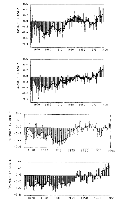
Figure 5-12
Change in mean (a) land and (b) sea surface temperatures recorded by instruments since
1861, relative to 1951-1980 mean. The top and bottom panels of each pair represent the
Northern and Southern Hemispheres, respectively. (a) Land data: annual values from P.D.
Jones; smoothed curves from Jones (1988) (solid), Hansen and Lebedeff (1988) (dashed),
and Vinnikov et al. (1990) (dotted). (b) Sea surface data: annual values from U.K. Meteorological
Office; smoothed curves from UKMO (solid) and Farmer et al. (1989) (dashed). (All figures
from IPCC, 1990; reprinted with permission of the Intergovernmental Panel on Climate Change.)
Page 65
frequency variability, which has been emphasized through annual averaging and time filtering. The cause of these low-frequency fluctuations is still debatable. Of course, higher-frequency fluctuations exist as well. These fluctuations are due to the internal variability of the climate system, and are governed by, among other things, the atmospheric circulation's response to forcing and to changing boundary conditions.
Interdecadal variability in instrumental temperature records, both global and hemispheric, was contrasted with interannual variability by Ghil and Vautard (1991). The 15-and 25-year near-periodicities detected in the relatively short (135-year-long) records of Jones et al. (1986a,b) and shown in IPCC (1992) have been confirmed with high statistical significance in much longer proxy records having annual resolution (Quinn et al., 1996; Biondi et al., 1997), as well as in the longest available (335 years of local temperature) instrumental record (Plaut et al., 1995). The spatial patterns and physical mechanisms associated with these broad spectral peaks are the focus of intense current research. Thus the 13-to-15-year peak has been associated with variability of the North Atlantic current system (Sutton and Allen, 1997; Moron et al., 1998), while the 20-to-25-year peak has been associated with oscillations in the thermohaline circulation (Delworth et al., 1993; Chen and Ghil, 1996).
A striking example of decadal variability in the atmospheric circulation is evident in Figure 5-13. The decades of 1950-1959 and 1980-1989 were both warm intervals (see the global means in Figure 5-12), yet the geographic distributions of surface-temperature anomalies for the two are significantly different from one another, indicating that the atmospheric circulation had changed considerably. The seasonal distribution of global mean temperature also attests to the importance of atmospheric circulation in climate variability (see Wallace et al., 1993).
In the tropics, ocean-atmosphere interaction leads to a unique ENSO climatic signal (see Chapter 3). While this interaction occurs in the equatorial Pacific, the response of the atmospheric circulation to ENSO is global (Rasmusson and Wallace, 1983). Because of its strength and global influence, and because it has been shown to be predictable up to a year in advance (see, e.g., Barnett et al., 1988, and Barnston et al., 1994), ENSO is arguably the most important mode of climate variability on interannual time scales (see, e.g., Glantz, 1996). In recent years increased attention has been given to the variability of ENSO on decadal and longer time scales (Trenberth and Hurrell, 1994). In particular, the existence of the recent long interval of warm tropical sea surface temperature (SST) in the eastern Pacific and negative Southern Oscillation Index (shown in Figure 5-14) have initiated various speculations on the origin of decadal variability in the tropics and on the nature of the link between these tropical variations and mid-latitude atmospheric circulation (Trenberth, 1995; Latif et al., 1996). Because of the implications of ENSO for global climate, it is imperative that we strive to better understand and predict decadal variability in the tropics. Other examples of tropical variability important to society are the long-term fluctuations of monsoon and Sahel rainfall (see Chapter 4).
In the mid-latitudes, the low-frequency variability of atmospheric circulation—as reflected, for example, by anomalous distribution of sea level pressure and geopotential height—displays the distinct spatial patterns described in Chapter 3. Most clearly discernible during winter, the pressure fluctuations associated with such teleconnection patterns as the PNA and the NAO regulate the meridional distribution of temperature, and moisture advection and convergence, in their region of influence (Trenberth and Hurrell, 1994). In recent years it has become clear that these teleconnection patterns display variability on decadal and longer time scales. For instance, wintertime sea-level pressure (SLP) in the Aleutian low region remained persistently lower than normal for more than a decade between 1977 and 1988 (Trenberth and Hurrell, 1994). The surface pattern during this period and its mid-tropospheric counterpart (see Zhang et al., 1997) resemble the PNA pattern (Figure 5-15). Such a climatic configuration tends to lead to a warmer-than-normal western North America and a somewhat colder-than-normal eastern North America. Changes in baroclinic-eddy activity over the Pacific and North America are also involved in this climatic perturbation.
Over the North Atlantic, SLP has been falling in the Icelandic low region and rising near the center of the Azores high since the 1960s, indicating a remarkably long trend in the strength of the NAO (Hurrell, 1995). Such climate-regime changes are linked to changes in wind distribution and storminess over the North Atlantic, and to the severity of winters (rainfall and temperature) downstream in Europe, Asia, and North Africa (Hurrell and van Loon, 1996).
The NAO and PNA circulation features, which occur predominantly over the ocean basins, are connected with distinct changes in ocean temperature and circulation. They may indicate the existence of a coupled interaction between the atmosphere and ocean that is crucial to understanding and predicting dec-cen variability.
Mechanisms
As noted in Chapter 4, three types of interaction govern the variability of the atmospheric circulation:
1. External forcing (solar, volcanic, and anthropogenic);
2. Interaction with the other components of the climate system (ocean, land, cryosphere, and biosphere); and
3. Internal atmospheric interactions (transient-transient and transient-mean interactions, and other nonlinearities).
The relationship between atmospheric-circulation variability and external radiative forcing has not been clearly resolved. Many studies have attempted to identify periodic
Page 66
behavior in a number of atmospheric variables that could be attributed to periodic changes in solar forcing. One of the loci of this search has been ascertaining the climatic response to orbital fluctuations on millennial time scales (Imbrie et al., 1992)—a topic beyond the scope of this document. Many attempts have also been made to detect a climate response to shorter-scale variations in solar forcing. One prominent example is the search for effects of the periodic 11-year fluctuations in solar luminosity and its 22-year modulation (see the "Atmospheric Composition and Radiative Forcing" section of this chapter). Satellite observations (available for only one and a half sunspot cycles so far) indicate that during a period of sunspot maximum, solar irradiance is higher by more than 1 W m-2 than it is during a sunspot minimum. Since the lower atmosphere absorbs only a small portion of incoming solar radiation, it is hard to see how such a weak signal can affect climate unless a positive feedback exists in the climate system. Such mechanisms have been proposed
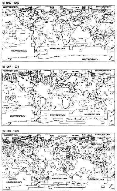
Figure5-13
Decadal surface-temperature anomalies relative to 1951-1980. The contour interval is 0.25ºC.
The 0ºC contour is dashed. Dash-filled areas have negative anomalies less than -0.25ºC;
white areas have anomalies between -0.25ºC and +0.25ºC; dot-filled areas have positive
anomalies between 0.25 and 0.75ºC; striped areas have positive anomalies greater than
0.75ºC. (From IPCC, 1990; reprinted with permission of the Intergovernmental Panel on
Climate Change.)
Page 67
but not authenticated (see, e.g., Hansen and Lacis, 1990). Nonetheless, evidence of just such an effect in the climate record (see Mitchell et al., 1979; Cook et al., 1997; White et al., 1997b), while compelling, has generally been received with skepticism (e.g., Pittock, 1978, 1983). The main reason for such skepticism is the weak impact these fluctuations have on the solar constant (~0.1 percent, see Sarachik et al., 1996). The subject has recently received renewed attention, both because of popular concern about anthropogenic global climate change and because of the apparent changes in sunspot cycles over long (centennial) time scales (Kelly and Wigley, 1992; Schlesinger and Ramankutty, 1992; Lean et al., 1995). (The atmospheric response to changes in anthropogenic radiative forcing was discussed more fully in the "Atmospheric Composition and Radiative Forcing" section of this chapter.)
Volcanic eruptions may release large amounts of aerosols and gases into the troposphere and the lower stratosphere, as noted earlier. In the stratosphere the residence time of volcanic aerosols is longer, allowing them to be distributed around the globe by stratospheric winds. These stratospheric aerosols are responsible for a complex radiative interaction, involving the absorption of both solar and terrestrial radiation, that can have a significant influence on climate (Lacis et al., 1992). The effect of Mount Pinatubo's eruption in the summer of 1991 on the climate of the following winter has been much discussed (e.g., Hansen et al., 1992). However, it appears that individual strong volcanic eruptions affect the atmosphere for only short periods of time (1-2 years) before the aerosols are flushed out of the lower stratosphere (Sear et al., 1987; Bradley, 1988; Mass and Portman, 1989). Thus, a series of major explosive volcanic events would be needed to produce a long-term effect on climate.
The issue of volcanic influence on long-term climate variability has been the subject of speculation and debate over the last several decades (Budyko, 1969; Zielinski et al., 1994). Attempts are being made to construct a record of past explosive volcanic eruptions so that their effects on climate can be explored (Bradley and Jones, 1992; Robock and Mao, 1995). It is interesting to note that several reconstructions of volcanic activity indicate a long span, from 1920 to 1960, of low stratospheric-dust levels—a period during which global atmospheric temperature generally increased and peaked (Robock, 1991). Increased volcanic activity between 1960 and 1980 parallels a period of global cooling that began in the early 1960s.
Myriad intricate interactions within the atmosphere, and between it and each of the other components of the climate system, give rise to feedbacks that can either amplify or weaken the effect of external forcing. For example, atmospheric circulation determines the vertical and horizontal distribution of moisture, radiatively active gases, clouds, and aerosols. Because the vertical and latitudinal distributions of these constituents influence the radiative forcing of the planet, changes in atmospheric circulation directly affect the global mean temperature and its horizontal and vertical distribution. Changes in temperature in turn affect the distribution of winds and their convergence patterns, leading to changes in evaporation, in the atmospheric moisture content and its distribution, and ultimately to changes in radiative
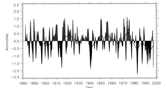
Figure 5-14
Standardized monthly and low-pass filtered time series of a Southern Oscillation Index (SOI) computed as
the negative of sea-level pressure at Darwin, Australia. It is one of the key indicators used to assess tropical
atmospheric activity associated with El Niño. (After Trenberth, 1984; reprinted with permission of the American Meteorological Society.)
Page 68
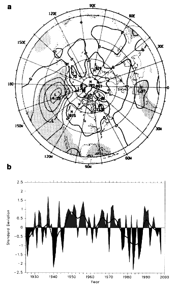
Figure 5-15
(a) The anomalous November-through-March averaged SLP differences during the
period 1977-1988 with reference to the period 1924-1976. Note the resemblance to
the 500 hPa PNA pattern shown in Figure 3-2a. (b) Time series of the November-
through-March averaged SLP anomaly in the region 160ºE-140ºW, 30-65ºN. (From Trenberth
and Hurrell, 1994; reprinted with permission of Springer-Verlag.)
forcing. It is crucial to study these interactions and to better understand the behavior of climate on both short and long time scales. Several recent studies have examined whether such interactions should lead to a stable or an unstable tropical climate in the presence of external forcing (Pierrehumbert, 1995). Similarly, interactions among the atmosphere, cryosphere, and ocean explain the poleward amplification of the warming signal observed in the recent climate record and in climate models forced with increased CO2 (see, e.g., Meehl and Washington, 1995).
It is commonly assumed that if the atmosphere were not interacting with the other components of the climate system, the spectral energy of its variability would not increase on time scales longer than that of the annual cycle. While this assertion may be disputed (James and James, 1989; Lorenz, 1990), fluctuations in the atmospheric circulation on the dec-cen time scale that do not arise from changes in external forcing are most likely influenced by atmospheric interactions with the more slowly varying parts of the climate system. For instance, ocean-atmosphere interaction gives rise to ENSO variability in the tropics, and may, through teleconnections, explain decadal-scale variability in the mid-latitude Pacific (Graham, 1994). The possibility of direct atmosphere-ocean interactions in the mid-latitudes themselves has also been noted, most recently by Latif and Barnett (1994, 1996) and Barsugli and Battisti (1998). Latif (1998) classifies interdecadal atmosphere-ocean variability into four classes: tropical interdecadal variability; interdecadal variability that involves both the tropics and the extratropics as active regions; mid-latitude interdecadal variability involving the wind-driven ocean gyres; and mid-latitude variability involving the thermohaline circulation. Long-term changes in precipitation patterns in the subtropics (e.g., the Sahel) have been attributed both to changes in global SST (Folland et al., 1986) and to positive feedback from land-surface processes (Charney, 1975). Whichever the cause of the variability is, and wherever it originates, the atmospheric circulation can distribute the outcome over wide regions, and communicate its effects from ocean to land and vice versa.
The way the atmospheric circulation responds to external forcing and to interactions in the climate system is determined by dynamic laws governing the atmospheric flow. Several specific dynamic and thermodynamic mechanisms have been proposed to explain the atmospheric response in terms of patterns and teleconnections. It has been suggested that the global effects of ENSO, particularly in the extra-tropics, are the result of planetary stationary waves, forced at the tropics by deep tropospheric heating, that distribute energy into the mid-latitudes (Hoskins and Karoly, 1981). This theory successfully explains the seasonal dependence of the extratropical response, and to some extent its phase with respect to longitude. Transient interactions with mid-latitude baroclinic and stationary eddies must also be included to make this explanation complete, however (Hoskins, 1983; Simmons et al., 1983). In the mid-latitudes, similar dynamics explain the shape and location of atmospheric teleconnection patterns, but the response to surface forcing is less well understood (see Kushnir and Held, 1996, and references therein).
The appearance of similar spatial patterns in the atmosphere's intraseasonal, interannual, and interdecadal variability (see Chapter 3) indicates that at least some of these patterns correspond to basic modes of internal variability of the atmosphere. It has been suggested (Legras and Ghil, 1985; Palmer, 1993) that the bridging of time scales that is apparent in these common spatial patterns might be due to
Page 69
the fact that changes in the atmosphere's surface boundary conditions affect the frequency of occurrence of one or more weather regimes (Reinhold and Pierrehumbert, 1982; Ghil and Childress, 1987). Supporting evidence for this idea has been provided by Horel and Mechoso (1988) and Kimoto (1989). Further discussion of possible mechanisms governing decadal climate variability can be found in WCRP (1995), Latif et al. (1996), and Sarachik et al. (1996). A review of coupled ocean-atmosphere modeling studies of decadal-scale variability is given by Latif (1998).
Predictability
The pioneering work of Lorenz (1963, 1969), and the research it spurred over the years, established that the atmospheric flow, on the scale of individual weather disturbances, is predictable only a week or so in advance. Climate prediction is based on the expectation that part of the atmospheric circulation is evolving more slowly, either because of its internal dynamics or because of slowly changing boundary conditions (land and ocean surface properties). In moving beyond the limits of weather prediction, we hope to be able to specify future mean or variance conditions in terms of their relation to normal conditions, and to define the degree of uncertainty in that prediction. Because of its strategic societal importance, climate prediction has been actively studied for many years (Namias, 1968). In the tropics these studies have born fruit in the form of the discovery that ENSO is predictable up to a year or more in advance (Cane and Zebiak, 1987; Barnett et al., 1988; Barnston et al., 1994). It has proven more difficult to infer the global response of the atmospheric circulation from knowledge of upcoming conditions in the equatorial Pacific (Barnett, 1995). Attempts at seasonal-scale prediction of other atmospheric features, such as tropical cyclone activity and terrestrial rainfall in semiarid regions, show skill and promise (Palmer and Anderson, 1993; Hastenrath, 1995; see also the Center for Ocean-Land-Atmosphere Studies quarterly Experimental Long-Lead Forecast Bulletin (http://www.iges.org/ellfb)). The implications of these capabilities for our ability to make longer-term forecasts or predictions are not yet clear, however.
Chapter 4 distinguished between two types of prediction: non-initialized, an example of which is the prediction of the response to the anthropogenic addition of greenhouse constituents; and initialized, exemplified by detailed prediction of the boundary conditions that determine the atmospheric statistics, which requires the specifications of initial conditions tied to a given point in time. The importance of climate variability on decadal and longer time scales has been demonstrated by the drop in skill of ENSO-prediction methods earlier in this decade, followed by a recent increase in skill. It is hypothesized that decadal variability in the Pacific ocean-atmosphere system is responsible for the recent change in the characteristics of ENSO (Latif et al., 1996). Little is known about the predictability of climate on the dec-cen scale, though recent modeling results (Latif and Barnett, 1996) show the possibility of 5-to-6-year prediction of North Pacific SLP patterns, which are directly related to atmospheric circulation and the PNA pattern. Clearly this question cannot be addressed until it has been established that climate models are capable of representing the range of dec-cen variability displayed in the instrumental and proxy records.
Remaining Issues and Questions
Many of the remaining issues and questions about the role of atmospheric circulation in dec-cen variability are related to climate patterns, interaction with other climate-sys-tem components, and the role of changing boundary conditions in triggering and maintaining long-term circulation anomalies (see Chapter 3 and other sections of Chapter 5). Here we highlight the issues especially important for atmospheric circulation.
• How much of the dec-cen variability in atmospheric circulation is unforced? For example, to what extent are dec-cen-scale circulation variations related to PNA, NAO, and other climate patterns driven by natural atmospheric variations that are produced through nonlinear interactions in the atmosphere? What role do coupled interactions with the other components of the climate system play in the atmosphere's dec-cen natural variability? Are some or all of these variations driven or shaped by changes in the radiative forcing resulting from an anthropogenic increase of greenhouse gases, changes in the levels of natural (e.g., volcanic and surface dust) or anthropogenic aerosols, or variations in solar radiance?
• How do global-scale, dec-cen circulation changes affect regional-scale, higher-frequency climate variability and severe weather? We need to better document, understand, and predict the local and higher-frequency outcomes of dec-cen-scale changes in atmospheric circulation. The societal impacts of dec-cen variability are determined primarily by changes in regional climate states, storm tracks (both mid-latitude and tropical), and rainfall, which typically vary over shorter time scales. In other words, how do variations in the mean climate state influence the spatio-temporal distribution of the higher-frequency variance, and how might this relationship be used to exploit knowledge of long-time-scale variations to make shorter-time-scale climate predictions?
• What are the magnitudes, spatio-temporal patterns, and mechanisms of the mid-latitude atmospheric response to both mid-latitude and tropical SSTs? The hypothesis that the ocean plays a key role in dec-cen climate variability hinges on the ability of the atmosphere to respond to changing SST conditions, and the patterns of its responses. While we now have a solid understanding of how this response occurs in the tropics, we do not yet fully understand how the tropical response is communicated to the mid-latitudes. Even
Page 70
less clear is the nature of the atmospheric response to mid-latitude SST, for which theory, observations, and modeling are not yet consistent. Several mechanisms have been hypothesized to explain observed teleconnections between the tropical and extratropical latitudes, and the contributions they might make to dec-cen variability—for example, slower propagation of anomalies back to the equator via ocean processes and faster propagation from the tropics via atmospheric processes. These processes must be evaluated to determine their importance in explaining climate variability, the dominant mechanisms by which they occur, and how they maintain and propagate anomalies. The exploration of the spatial extent of such teleconnections should also be continued to determine more fully the scales over which local and regional anomalies and influences can be communicated. Moreover, links to tropical SST and the decadal variability of ENSO should also be investigated more fully, as well as links to variations in the annual cycle of the Southern Hemisphere. Further investigation into the origin and maintenance of these phenomena, and their mutual relationships, is warranted.
• What are the mechanisms of interaction between the atmosphere and land-surface processes on dec-cen time scales? Land-surface characteristics, such as snow and ice cover and soil moisture content, are known to affect short-term (interannual) climate variability. Longer-term fluctuations may also be related to variations in land-surface characteristics. Changes in the lower boundary conditions may initiate regime changes in the atmosphere, which may emerge as dec-cen-scale climate variations. The land surface's ability to extend the memory of the climate system, even though smaller than the ocean' s, can be important in such regime shifts.
• What are the mechanisms of region-to-region and basin-to-basin interaction on the dec-cen time scale? Given our short instrumental records and a limited number of long coupled atmosphere-ocean GCM simulations, the issue of cross-basin and remote interaction of climate anomalies remains a largely unresolved problem. The most dramatic climatic events of the last 20 to 30 years appear to be related to almost synchronous long-term climate-regime changes over the North Pacific and North Atlantic regions, as well as in the tropics. It is not clear whether this coherence is coincidental or whether these changes arose through dynamic linkages between these regions. Furthermore, it is not clear to what extent these synchronous changes were driven by anthropogenic effects. On geological time scales, other dramatic climatic events in the Earth's history (e.g., deglaciation; see Bender et al., 1994) were nearly global in extent. While many of these changes happened on longer time scales, there is little doubt that understanding them is helpful for understanding dec-cen variability, because some of the underlying mechanisms driving past changes might be responsible for changes occurring in the future. In addition, some climatic events documented in ice cores and elsewhere indicate that major climate-system reorganizations can take place in a matter of decades (e.g., the Younger Dryas termination; see Alley et al., 1993).
• How do dec-cen-scale changes in atmospheric trace gases, aerosols, and cloud cover affect radiative balance and thus atmospheric circulation, and vice versa? The delicate feedback mechanisms associated with the interaction between radiation and dynamics are not well understood. Sub-grid-scale parameterizations are involved in modeling these feedback mechanisms, and need to be put on a more robust physical basis. There has been considerable controversy recently about the sufficiencies of model simulations of upper-tropospheric moisture transport and phase changes, about the role of anthropogenic aerosols in climate change, and about the role of clouds in stabilizing the global climate. These important issues need to be resolved if we are to simulate and predict dec-cen variability.
Observations
The study of dec-cen variability of the atmospheric circulation faces many challenges. The widespread current interest in anthropogenic climate change has motivated the climate-research communities to reorganize the available instrumental and proxy data and to increase the volume of their archives through data ''archeology" and additions of new data. These efforts need to proceed in tandem with the establishment of clear guidelines for future atmospheric observations, and with long-range, coordinated planning of the observational networks so that adequacy, continuity, and homogeneity of the observational records are assured. Observations should focus on describing both the state variables—wind, pressure, temperature, humidity, and rainfall—and the forcings or related variables—solar radiation, clouds, aerosols and chemical composition.
Processes and Parameterizations
Models of the climate system are a powerful tool for the study of climate variability, as Chapter 6 will make clear. Such models must be developed further until they are comprehensive enough to allow the coupled simulation of ocean, atmosphere, cryosphere, and changes in continental surface conditions. The processes controlling the evolution of all these important components must be improved in atmospheric-circulation models so that the dominant interactions driving long-term climate change in the atmosphere can be properly evaluated. In particular, the processes controlling the feedbacks and interactions between water vapor, cloud-formation processes, and atmospheric circulation must be better understood and parameterized. These processes are particularly important for tropical regions, where convective activity and cumulus formation exert the dominant control on atmospheric dynamics. Also, the processes controlling the boundary-layer physics, including all interactions (e.g.,
Page 71
exchange of heat, moisture, and momentum) and feedbacks, need to be better understood. Much of the dec-cen variability in the atmospheric circulation arises through interactions and coupling with the boundaries, yet this complex interface region is poorly understood, and poorly resolved in models. Because of climate models' relatively coarse vertical resolution, the dynamics of this interaction cannot be resolved in models, so they must be parameterized in terms of large-scale circulation quantities. Our ability to correctly model the atmospheric response to greenhouse-gas increases and to natural surface-temperature and moisture anomalies, as well as the ability to correctly force ocean models, depend on boundary-layer processes. Finally, the processes controlling the large-scale wave features and their interaction with the major climate patterns described in Chapter 3, including such shorter-time-scale features as ENSO, must be better understood to be correctly represented in models.
Hydrologic Cycle
The Earth's hydrologic cycle involves the movement of the planet' s water through its many phases in the atmosphere, ocean, and land. Water evaporates from the surface of both the land and the oceans, condenses in the atmosphere, and precipitates back onto both the land and ocean surfaces. Ultimately it finds its way back into the atmosphere as vapor, sometimes residing in surface or subsurface reservoirs for hundreds or thousands of years, or longer, before completing the cycle. (For convenience, snow and ice are dealt with in detail in the "Cryosphere" section of this chapter, rather than directly below, even though they are an important part of the cycle.) In the course of this cycling, water influences all of the climate attributes discussed in Chapter 2. The hydrologic cycle involves complex interactions with factors such as vegetation and clouds, as well as atmospheric and oceanic circulation. For instance, atmospheric circulation helps determine the convergences and divergences of vapor (and thus the ratio of precipitation to evaporation for a given locale), but the condensation processes in turn help determine the circulation of the atmosphere.
Influence on Attributes
The hydrologic cycle is obviously the dominant control of the climate attribute of precipitation and water availability. It also directly influences sea level. If more precipitation falls as snow than is returned by evaporation (or sublimation, the direct vaporization of the snow cover), the snow will accumulate. Eventually it will form glaciers, which can account for considerable changes in sea level. In fact, aside from the local sea-level changes associated with the coast-land response to the weight of the waxing and waning continental ice sheets, the largest changes in sea level arise from the addition or subtraction of freshwater as those ice sheets change in size. During the last ice age, enough freshwater was removed from the oceans and stored in continental ice to lower the sea level by more than 120 m. In the relatively moderate climate conditions of the past century, the return of freshwater to the oceans from melting alpine glaciers, and possibly from the existing continental ice sheets, is thought to be responsible for approximately half of the 20 cm sea-level rise that has been observed.
The amount of water involved in these sea-level changes is small relative to the total amount of water involved in the hydrologic cycle (see Figure 5-16). About 16 million metric tons of water falls on the Earth every second. In the mean,
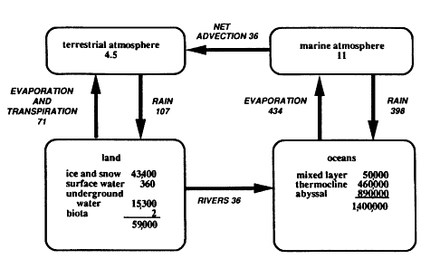
Figure 5-16
Gross budget of the mean global water cycle: Reservoir figures are in 1015 kg, fluxes in 1015 kg
per year. (From Chahine, 1992; reprinted with permission of Macmillan Magazines, Ltd.)
Page 72
assuming a nearly steady state, roughly that same amount must leave the surface. Note that 1 million metric tons per second corresponds to 1 sverdrup in oceanographers' units and to 32,000 km3 per year in the units more commonly used by hydrologists. It should also be noted that the figures for global fluxes given in Figure 5-16 are uncertain to about 10 percent.
About 80 percent of the total precipitation falls on the surface of the ocean, where it reduces the local salinity, or, if it falls as snow on sea ice, raises the local albedo. Likewise, where precipitation falls as snow on land, it raises the local albedo and influences the regional radiation budget. Of the total water leaving the surface of the Earth, 85 percent evaporates from the surface of the ocean. Some of the water vapor evaporated from the oceans (36,000 km3 per year, or 8 percent) must be diverted from ocean areas to over land, where it condenses as precipitation, in order to balance the water that flows as runoff from land to ocean (Chahine, 1992). The total rainfall over land, 107,000 km3 per year, arises from local evaporation and from the aforementioned importation of marine vapor.
Climate variability at decadal to centennial time scales translates into significant impacts on surface and subsurface hydrology and, thus, on water-resource management. Regional flood potential, water-quality trends, hydropower and recreation potential, and irrigation and municipal-water demands and supply are modulated at these time scales as a function of climatic variability. Dec-cen climate variability is especially important because decisions on project sizing, as well as policies governing water-project operation, are based on an analysis of 10 to 30 years of data, and on the assumption that the underlying processes are stationary. These decisions undergo severe tests in the subsequent period. Look, for example, at the Colorado River compact that allocates the water of the Colorado River between California and other Western states. The water was initially allocated on the basis of flows over a prior 30-year wet period. (Decadal-scale variability in the Colorado River flow can be seen on the lower curve of Figure 5-17.) When Glen Canyon Dam was built on the Colorado, it was sized on the basis of data from a similar period. Not for 30 years, until the record E1 Niño event of 1982-1983, was the reservoir behind Glen Canyon Dam filled. It is now felt that the Colorado River is over-appropriated. A related situation involving changing flood frequency has occurred on the American River above Sacramento, California. The Folsom Dam, built in 1945, provides flood protection for Sacramento. However, the flood frequency in this basin has changed since its construction; eight floods greater than the largest flood in the 1905-1945 period have occurred since 1945. This has led to concern about the level of flood protection actually provided by the dam, and, more important, how flood risk should be analyzed. A better understanding of dec-cen variability at regional scales will clearly have a significant impact on the water-resources sector.
An adequate water supply is critical to the health of natural ecosystems, as well as to human habitation. Low-flow periods in streams lead to higher pollutant concentrations
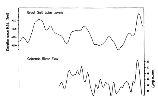
Figure 5-17
Time-series measurements of the level of the Great Salt Lake and the flow of the
Colorado River. (From Diaz and Anderson, 1995; reprinted with permission
of the American Geophysical Union.)
Page 73
and to an increased potential for damage to aquatic habitat. This situation is exacerbated by human activity during protracted drought. Increased pumping of groundwater may further reduce baseflow in streams. This groundwater may be used for irrigation, in which case the surface or subsurface agricultural runoff will carry nutrients at high concentrations into streams. The threat to water quality from such conditions is the most critical in the last 200 years, given the changes in agricultural practices, the marginal water quality in many rivers, and the precarious balance between supply and demand, particularly in the midwestern and western states. Catastrophic impacts on the ecological, agricultural, hydropower, recreation, and municipal-use sectors would take place if a drought such as that of the 1930s were to recur.
The hydrologic cycle also influences ecosystems, because the supply of freshwater is central to terrestrial life. Because much of the evaporation from the land's surface is in fact water transpired from the soil to plants through their root systems and then evaporated from the stomata in their leaves, the total vapor leaving the land surface is referred to as evapotranspiration. In this respect, ecosystems influence the hydrologic cycle. Since the evapotranspiration over land is 71,000 km3 per year, the 36,000 km3 per year that remains from precipitation is available as surface water, or finds its way into the soils. Ultimately this surface water is captured in drainage basins (see Figure 5-18 for the major basins), and rivers transport it back to the oceans. Only about 10,000 km3 per year of this surface water is available as global renewable freshwater resources serving all human, agricultural, and industrial purposes for the entire world's population (Cohen, 1995; Postel et al., 1996). It is of interest to note that if the entire world used the same amount of renewable freshwater per capita as the United States (2,100 m3 per year per person), the globe could not support more than 5 billion people, which is less than its current population (Cohen, 1995).
Rind et al. (1997) show that under a doubled CO2 scenario, vegetation changes would constitute only a moderate feedback to climate. However, such a warming's impact on ecosystems, particularly vegetation itself, could be dramatic because of hydrologic stress. In their GCM simulation with interactive vegetation, the impact of increased hydrologic activity is particularly enhanced over land, driving considerable evaporation from the vegetation through transpiration. The vegetation attempts to limit this drying by closing stomata. This tactic enables vegetation to survive short-term, drought-like conditions, but in the long run reduces productivity and eventually destroys the vegetation (particularly in lower latitude zones). This result is not revealed in simple GCM studies that do not include a treatment of vegetation strain response, such as those used in the first IPCC assessment (IPCC, 1990), though it is indicated in impact studies such as those used in the second IPCC assessment (IPCC, 1996a). Likewise, Sellers et al. (1996) reveal that changes in stomatal resistance under doubled-CO2 scenarios feed back
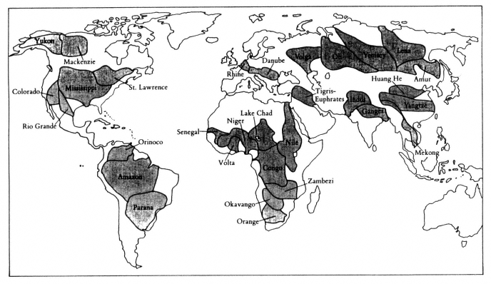
Figure 5-18
The world's major drainage basins. (From WRI, 1996; reprinted with permission of the World Resources Institute.)
Page 74
into the hydrologic cycle. Betts et al. (1997) find that changes in the type and extent of vegetation canopy resulting from CO2 fertilization and CO2-induced climate changes would also have significant effects on the hydrologic cycle.
Finally, the hydrologic cycle influences global temperature, since water vapor is the Earth's primary greenhouse gas. That is, while carbon dioxide is probably the most notorious of the greenhouse gases, the real danger from increased carbon dioxide is the potential of altering the hydrologic cycle and increasing the amount of water vapor residing in the atmosphere beyond what is typically present. This increase could significantly amplify the relatively small direct warming associated with carbon dioxide.
The issue of upper-level water-vapor feedback was raised by Lindzen (1996). He argues that, in the tropics at least, upper-level water vapor will decrease, not increase, with the addition of greenhouse gases. Thus, in the tropics, the net water-vapor feedback from the entire atmospheric column could be weak or negative, rather than strongly positive (which would be the case if upper-level water-vapor concentrations were to increase). The total magnitude of the response to added greenhouse gases without a strong positive water-vapor feedback would be relatively small. It is difficult to make direct measurements of upper-level water vapor, however, and the results to date are contradictory (see Chapter 4 of the second IPCC assessment (IPCC, 1996a) for a summary of observations).
Consequently, the mean hydrologic cycle is inseparably intertwined with the mean climate of the globe. Since each of the processes composing the hydrologic cycle involves the other processes, the role of hydrology in the climate system is exceedingly complex, and a thorough understanding of its influences, feedbacks, and sensitivities still represents one of the largest challenges facing the climate community.
Evidence of Decade-to-Century-Scale Variability and Change
Estimates of the mean annual fluxes, reservoirs, and processes associated with the global hydrologic cycle are hard won and still relatively uncertain, and the year-to-year variability of the global cycle is poorly known. Not surprisingly, there is a paucity of information documenting the long-term variability of the hydrologic cycle. Variability is more easily documented locally than at larger scales; it shows up as variability of precipitation, but also as variability of water storage and runoff. While there is everywhere a fast component of rainfall variability because of the short time scales of the atmospheric hydrologic cycle, here we are more interested in the slower changes. Proxies for precipitation (such as outgoing longwave radiation and microwave emissions) can be used to give a global view of precipitation processes and variability (Rasmusson and Arkin, 1993). For very long time records (e.g., 100 years), however, station data for precipitation must be used, because most relevant satellite-based observations extend back little more than a decade into the past. An investigation of the adequacy of the U.S. and southern Canadian station networks by Groisman and Easterling (1994) has shown that useful climatological information and statistics can be gathered from the existing station data in those regions. Dai et al. (1997) show evidence of decadal precipitation variability in their global gridded dataset of monthly precipitation anomalies.
There is some evidence (Keables, 1989; Dettinger and Cayan, 1995; Rajagopalan and Lall, 1995; Mann and Park, 1996; Baldwin and Lall, in press; Jain et al., in press) that the expression of temperature, precipitation, and streamflow ''seasonality" in the mid-latitudes has undergone significant changes at dec-cen time scales. While some of these changes in the intensity and timing of the annual cycles of warming and moistening may be related to ENSO activity, there are pronounced decade-to-century-scale trends that are unexplained. Such changes in seasonality are of considerable importance to water supply and demand and to water-re-source management. The surface hydrologic system may amplify such changes in the underlying climatic state. One example is the advance in the date of the peak annual flood in the American River in California that has accompanied the previously mentioned recent increase in flood magnitudes (Dettinger and Cayan, 1995). Warmer temperatures earlier in the year have apparently led to warmer, moister air masses flowing into the area, and also to more precipitation falling in the form of rain rather than snow. This heavy rain, falling on the snow that generally exists early in the year, has exacerbated the flood problem. Interestingly, years with early peak annual floods tend to have less rain in the late spring and early summer, posing a significant problem for reservoir operators and water managers. Reservoirs may be emptied in response to concern about high floods early in the year, leading to a serious water-supply problem later. The limited capacity of the reservoir system and the complicated institutional rules that govern reservoir operation expose the lack of resilience of managed hydrologic systems to climatic variability.
The terrestrial regions in which decadal-scale hydrologic variability is most evident are the Sahel and the United States. (Precipitation variability is extremely important for the Asian monsoon, but that variability is primarily inter-annual and is not discussed here.) In the United States, hydrologic variability is manifested not only as precipitation variability, but also as variability of streamflow and of storage. Figure 5-17 shows the temporal variation in the level of the Great Salt Lake as well as the flow rate of the Colorado River since the nineteenth century. The dramatic rise of the Great Salt Lake in 1983-1987, and the even more dramatic rise of Devil' s Lake, North Dakota, in 1982-1998, reflect the ability of the surface and subsurface hydrology to integrate the dec-cen climate signal. The American River floods also show a change in the seasonality of floods at dec-cen time scales, and both the timing and the change in flood frequency
Page 75
can be explained in terms of the large-scale climate fluctuations at dec-cen time scales (Lall et al., 1998). Even average precipitation years in such a run of events can lead to dramatic effects in the surface hydrologic system. Such hydro-logic changes can be large enough to have significant impacts on many systems (e.g., agriculture, natural ecosystems, and hydroelectric power generation) that are important to society.
Not only do these direct observations indicate decadalscale variability, but paleoclimatic records provide ample evidence of prolonged episodes of extreme hydrologic conditions. Dune fields (now vegetated) that were active during the past 1,000 to 10,000 years (Madole, 1994), tree stumps in modem natural lakes (Stine, 1994), long periods of slow growth revealed in drought-sensitive tree-ring records (Cook et al., in press), and more localized records (see, e.g., Laird et al., 1996; Madole, 1994; Muhs and Maat, 1993) all indicate that droughts more intense and prolonged than the U.S. Dust Bowl period have recurred throughout the past few millennia. Ancient dune fields in the Great Plains, now covered by vegetation, imply that the ability of this region to maintain vegetative cover without human intervention is marginal (Madole, 1994). There are indications of droughts in California at approximately the same time as those in the Great Plains (Stine, 1994). Evidence supports the existence of extreme droughts in Patagonia during these common periods, suggesting a common global cause for all these droughts. Tree-ring records from California spanning several millennia indicate periods of below-average rainfall lasting on the order of a millennium (Hughes and Graumlich, 1996). It is currently believed that discharges from the melting ice pack that covered much of the mid- to high latitudes of North America during the last glacial maximum significantly influenced thermohaline circulation, and thus the temperature, of the North Atlantic. Modulations by iceberg discharges (Heinrich events) are thought to have caused significant punctuations in the climate record of this region throughout the glacial period (see, e.g., Broecker, 1994, and references therein).
Mechanisms
The hydrologic cycle varies as a function of internal, coupled, and external mechanisms. Regarding the latter, it is generally agreed that the addition of radiatively active gases to the atmosphere will warm the Earth's surface (the degree of warming is in dispute) and significantly speed up the hydrologic cycle, so that the total global evaporation and precipitation should both increase. This is one of the most consistent predictions of change in models simulating anthropogenic greenhouse warming. Rind et al. (1997) suggest that a doubling of atmospheric CO2 would increase the precipitation and evaporation rate by approximately 10 percent, resulting in an increase in total atmospheric water vapor of 30 percent. Unfortunately, models probably cannot adequately estimate the net change and distribution of water vapor in the atmosphere, and not enough global data exist to confirm or refute their predictions. Trenberth (in press) does find evidence of increases in water vapor and in extreme precipitation events coincident with the recent global warming. Presumably, a change in the surface-radiation budget associated with a reduction of surface irradiation because of volcanic eruptions could drive a similar response in the hydrologic cycle.
Coupled mechanisms affecting the hydrologic cycle are easily illustrated by the well-known examples of variability mentioned previously, such as the precipitation variability in the Sahel and United States. Such coupled mechanisms have also been observed in several other regions, including the Brazilian Nordeste and Australia (see, e.g., Ropelewski and Halpert, 1987). Rainfall variability in both the Sahel and the United States has been correlated with SST variability in the oceans. For instance, Sahel rainfall has been correlated with SST variability in the tropical Atlantic (Folland et al., 1986). Much of this SST variability appears to be correlated with the Atlantic dipole's oscillation about the mean location of the intertropical convergence zone (ITCZ) in the Atlantic (Houghton and Tourre, 1992), influencing the location of atmospheric convection and the trade winds. However, SST in other regions of the globe has also been related to precipitation variability in the Sahel (Folland et al., 1991). Many of the SST-related processes in the Atlantic that seem to affect the location of the ITCZ on interannual time scales also seem to affect it on decadal time scales. Even less clear is why something in the ocean that varies primarily interannually should affect rainfall in the Sahel on longer time scales. At least two possible explanations have been offered: First, the rainfall and vegetation in the Sahel may be connected through a positive feedback, allowing them to produce longer-term variability than would exist without this feedback. Second, SST in other parts of the globe, especially the Indian Ocean, may vary on longer time scales than in the Atlantic, producing longer, decadal-scale modulations of Sahel rainfall (Ward, 1992).
Changes in the rate of the hydrologic cycle are expected to influence the budgets of precipitation and evaporation, and the linkages between these two processes can produce internal modes of variability. More complicated internal mechanisms undoubtedly exist, but have yet to be fully described or documented. River runoff fluxes may play a fundamental role in Arctic climate and the thermohaline circulation; it has also been suggested that complex, large-scale feedback loops (see, e.g., Slonosky, et al., 1997) link atmospheric convection and circulation to the hydrologic cycle and Arctic river runoff, to sea-ice formation and freshwater transport, and to the thermohaline circulation. Such relationships need to be more thoroughly investigated.
Rainfall variability in the United States correlates with S ST variations in the Pacific (Figure 5-19). Much of the U.S. precipitation variability is connected with SST in the North
Page 76
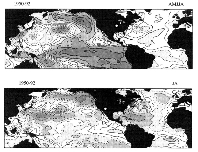
Figure 5-19
Correlation between U.S. rainfall at two sites, U.S. Great Plains (top panel) and Arizona (bottom panel), and SST
over the period 1950-1992. Rainy-season months included are noted above each panel. Positive and negative
correlation coefficients are indicated by solid and dashed isopleths, respectively (contour interval is 0.1). The
SST-precipitation correlations tend to be strongest (both positive and negative) in the Pacific Ocean, with some
exceptions. (Figure courtesy of T. Mitchell, JISAO/University of Washington.)
Pacific (Ting and Wang, 1997) and in the eastern and central equatorial Pacific (see, e.g., Ropelewski and Halpert, 1987). The ENSO phenomenon plays the most important role in producing this SST variability, and as a result of extensive developments in our understanding of this process and ability to model it, SST in the eastern Pacific can now be predicted with considerable skill a year in advance. Recently it has become more certain that ENSO itself is modulated by decadal processes of unknown origin, as discussed in Chapter 3. Since the teleconnections between the tropical (or subtropical) Pacific and the United States take place on relatively rapid (e.g., interannual) time scales, it seems likely that decadal modulations of SST will produce decadal modulations of precipitation in the teleconnected regions. As of this writing, it is clear that the decadal variability of ENSO has a broader meridional scale than its interannual variability (Tanimoto et al., 1993; Zhang et al., 1997), but it is not clear whether its dynamics are at all related to the interannual dynamics. Understanding the decadal variability of SST in the Pacific offers the best hope for skillful predictions of U.S. precipitation over medium and long time scales.
In most cases, it is not obvious how teleconnections influence drought. The mechanisms that initiate multidecade or multicentury droughts and enable them to persist. Feedbacks from vegetation and long-term SST anomalies that influence the supply and delivery of moisture are probably involved. However, no obvious mechanistic explanation is apparent even for the interannual-to-decadal droughts documented by instrumental records (e.g., the Dust Bowl of the 1930s and the killing droughts of the Sahel in more recent decades).
In contrast to droughts, floods are often thought of as high-frequency events caused by precipitation outbreaks with a duration of hours to days. However, flood (and the associated erosion and sediment yield) potential depends strongly on antecedent moisture conditions, on the baseflow in the stream, and on the state of the vegetation in the basin.
Page 77
Each of these factors will depend on the long-term state of the climatic forcing. A condition that leads to a wet period characterized by a sequence of moderate storms may result in a higher flood potential than a period with an intense storm. Likewise, anthropogenic changes in land use in a watershed over dec-cen time scales can significantly alter its response, and its water and sediment production potential. The interaction between anthropogenic and climatic factors at these time scales will be key to better flood-plain management.
The deeper groundwater reservoir responds at time scales of tens to thousands of years to climatic perturbations—rather like the response time of the ocean. Baseflow in streams represents a discharge of groundwater to the surface-water system that, because of its slow response time, is inherently characterized by low-frequency dynamics. Human influences also significantly modulate regional groundwater resources. Groundwater pumping, which tends to be greatest in dry periods, has led to significant declines (>100 m) in regional aquifers (often covering greater than 106 km2), such as the Ogallala aquifer in the central United States. These human and natural processes affect stream-aquifer interactions on dec-cen time scales. Moreover, the temporal distribution of the global hydrologic budget between the atmospheric, oceanic, surface, and subsurface reservoirs is likely being significantly affected as large amounts of groundwater are withdrawn and deposited in the other reservoirs. The resultant impacts on atmospheric water vapor, cloudiness, and regional precipitation are largely unknown.
Predictability
Prediction of the global hydrologic cycle is critical to our ability to predict the magnitude and distribution of anthropogenic greenhouse warming, because the hydrologic cycle influences greenhouse warming through a number of feedbacks, including those involving the distribution and amount of atmospheric water vapor. Successful prediction will require improved understanding of the intricate processes and atmospheric feedback mechanisms controlling water-vapor content, as well as better observations against which representations of our understanding can be tested. At present we cannot say how successful we will be in predicting the response of the hydrologic cycle to externally induced change, because our understanding of the present functioning of the hydrologic cycle is incomplete.
The directions of the feedbacks among the several elements of the interacting ecological, hydrologic, and climatic systems remains the source of some debate. The multi-scale nature of the dynamics serves to render the problem complex. However, to the extent that precipitation variability over land depends on SST variability, there is some hope of predicting precipitation several years in advance. SST predictions with this type of lead time might be possible if the ocean can be initialized accurately in models and if atmospheric "noise" does not overly contaminate the "signal" that exists in the depths of the ocean and eventually works its way to the surface. The atmospheric "noise" in the tropical Pacific is small, and SST in that region has been shown to affect rainfall and temperature over the United States. Fore-
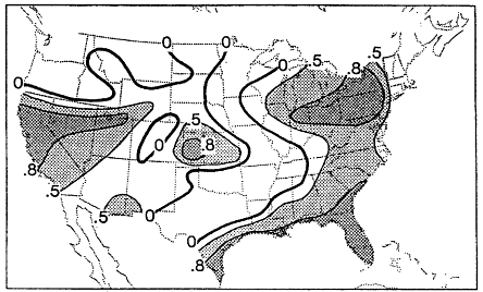
Figure 5-20
Correlation skill for 7-month forecasts of U.S. precipitation for January-February for seven strong ENSO
events made with the Scripps-Max-Planck-Institut coupled model. Skill is expressed as a correlation
between model forecasts and observations. (From Barnston et al., 1994; reprinted with permission of the
American Meteorological Society.)
Page 78
casting methodologies being developed on the basis of predicted SST in the tropical Pacific (Ji et al., 1994; Barnston et al., 1994) are already showing reasonable skill in forecasting U.S. precipitation two seasons in advance (Figure 5-20). More recently, Ting and Wang (1997) have found a relationship between mid-latitude North Pacific SST and U.S. precipitation. Dettinger et al. (1993) have shown a correlation of streamflow in the northwestern and southwestern United States with extreme ENSO events that may improve our ability to forecast precipitation and runoff, under certain conditions. Lall et al. (1998) have provided evidence for the strong correlation between dec-cen variations of ENSO and like variations in the streamflow of the San Juan and other rivers in the western United States. In addition, Lall and Mann (1995), Mann et al. (1995a), and Moon and Lall (1996) have connected fluctuations in the level of the Great Salt Lake to quasi-periodic variability organized at ENSO, decadal, and interdecadal time scales in the hemispheric circulation. Lall et al. (1996) and Moon (1995) have also provided remarkably successful multi-year (2-4 years ahead) forecasts of the level of the Great Salt Lake, using nonlinear time-series analysis methods on the historical time-series observations of the Great Salt Lake together with selected climate indicators. To take full advantage of such advances and to extend the range of hydrologic predictions over the United States will require the ability to predict SST further ahead, using comprehensive coupled models accurately initialized with ocean data.
For the Sahel, some skill seems to exist at ranges of a year or so, in the regular precipitation forecasts issued by the U.K. Meteorological Office, which utilize existing SSTs as predictors and assume that SSTs do not change during the period (Folland et al., 1991; Hulme et al., 1992). Again, since the prediction of precipitation changes is intrinsically a coupled atmosphere-ocean problem, greater skill in predicting Sahel rainfall will be realized through the use of more comprehensive dynamic coupled models that include SST predictions.
Additional factors that are important in predicting the hydrologic cycle are cloud physics and cloud-radiative feedbacks, which encompass a variety of fundamental processes that control or influence the formation, distribution, and evolution of clouds, in both the liquid-water and ice phases. The response of clouds to a change in the hydrologic cycle, and the subsequent impacts of that response, cannot be accurately predicted until the aforementioned cloud processes are understood well enough to be more realistically represented in models. Although cloud processes (e.g., cloud formation and changes in structure) operate on very short time scales, systematic changes in their character can have long-time-scale implications. Because clouds are thought to represent a sensitive component of the climate system, understanding them is critical to the goal of climate prediction on dec-cen scales. We need to better comprehend their temporal and three-dimensional spatial distribution and internal properties, including multi-layering and the cloud characteristics that affect the radiation balance.
Remaining Issues and Questions
To understand the hydrologic cycle better, we need to improve both our knowledge and the model representations of the processes controlling the rates, pathways, storage, and redistribution of water in all its forms in the hydrologic cycle. One of the dimensions of the WCRP's Global Energy and Water Cycle Experiment (GEWEX) program is an investigation of the detailed land-surface hydrology in major drainage basins. (The Mississippi basin is the primary U.S. focus, but concurrent land experiments are proposed for other parts of the world.) The basic issue is the parameterization of aspects of multi-scale land-surface properties and processes that are reliable across a wide range of climatic conditions and are appropriate for use in relatively coarse-scale models (e.g., NRC, 1998b). Among the most urgent questions are the following:
• What are the patterns of and mechanisms causing prolonged drought on dec-cen time scales? Paleoclimatic records reveal ample evidence of climate extremes that persisted for many decades or centuries in regions that experience quite different conditions today. Drastic consequences would ensue to such vulnerable and populous regions as California if such droughts were to recur during present times. An understanding of the conditions that could lead to such a situation, and its expected severity and duration, would be very valuable. The hydrologic aspects of an analysis to assess the initiation and persistence of droughts would include a better accounting of the global water balance, of changes in land-surface conditions, and the human use and natural drawdown of the near-surface and deeper reservoirs. A thorough examination of the patterns of past hydrologic variability, and the testing of plausible mechanisms with focused observational and simulation strategies, should lead to a better predictive understanding of this critical climate feature. An interesting aspect of this research would be the reconciliation of natural and human dynamics as they affect the hydrologic cycle. At present no research programs are investigating these issues at dec-cen time scales.
• How do the distribution of water vapor, precipitation, and clouds respond to and interact with surface boundary conditions and changes in forcings on dec-cen time scales? The hydrologic cycle plays a poorly defined role in producing and responding to the patterns of climate variability we have identified in Chapter 3. These patterns and large-scale precipitation seem to co-vary, however, so efforts to use knowledge of climate patterns to predict regional precipitation should be enhanced. There is clearly a need for better documentation and understanding of the nature and sensitivity of these co-varying relationships, and for establishing and refining the mechanisms responsible for driving them.
Page 79
In addition to improving model representations of the hydrologic cycle, we must also better document its temporal variability. The distribution of water vapor in the atmosphere, particularly the vertical distribution, needs to be better understood, because considerable controversy surrounds it. One theory about anthropogenic enhancement of the greenhouse effect suggests that increases in moisture in lower levels of the atmosphere will be offset by decreases in the upper troposphere, reducing surface warming (and its moisture increase) while cooling upper layers. If this offset does indeed occur, it would greatly reduce the net warming that would otherwise be anticipated to result from an increase in total atmospheric water vapor (see, e.g., Lindzen, 1996). As mentioned previously, direct measurements of water vapor in the upper levels of the atmosphere are difficult to make, and the results have been contradictory. Clearly, accurate treatment of upper-level water vapor is essential to realistic modeling of the climate system' s radiative response to anthropogenic increases in greenhouse gases (and other external forcing factors), and to reliably estimating the green-house-warming response.
• What combination of remote and in situ observations can be used to measure the large-scale distribution of precipitation and evaporation on dec-cen time scales? Precipitation is vital to nearly all of society's activities, and thus to the global economy. It is also a significant expression of dec-cen variability. While observed covariations suggest that teleconnections, such as those associated with the NAO and PNA, directly influence land precipitation, measurements that would confirm these relationships are poor, and are being made only sporadically. Existing global observation climatologies significantly disagree among themselves, so that not even a baseline of large-scale evaporation has been established. (A recent GEWEX initiative, the Global Precipitation Climatology Project (GPCP), now provides a baseline for precipitation.) Satellite measurements have now provided a global view of radiative proxies of precipitation, but the calibration needed to translate the proxy fields into precipitation is just starting to become credible, partly because of the GPCP results. In situ measurements are helping to quantify the radiation measurements made by satellites, which will permit absolute calibration of satellite measurements, as well as providing spatial-gradient information. Both the in situ and satellite measurements need to be continued in order to provide optimal estimates of large-scale fields of precipitation. Measuring evaporation is an even more difficult problem, though over the oceans a metric for precipitation-minus-evaporation (P-E) may ultimately be realized through monitoring of surface salinity fields by autonomous platforms. Knowledge of these fields is also critical for determining the ocean thermohaline circulation, as discussed in the next section. For measurements on dec-cen time scales, it is clear that a combination of remote and in situ systems must be designed to ensure long-term consistency and accuracy—which implies a commitment to long-term intercalibrated measurements.
• What spatial/temporal changes occur in the storage and pathways of land water, including the flux of water to the oceans, over decades and centuries? The buoyancy state of the ocean (defined by temperature and salinity) determines the water-transformation properties of the ocean, the rates of deep- and bottom-water production, and therefore ultimately the transport properties of the ocean and the stability of its internal oscillations (see the next section, "Ocean Circulation"). Crucial to these processes is the geographic distribution and amount of freshwater inputs—directly, by precipitation over the ocean, and indirectly, by input by runoff, groundwater discharge, and discharge of glaciers and other forms of land snow and ice, either through rivers or through ground discharge. The inputs' geographic distribution depends on the locations of rivers and their respective flows, and on the amount and distribution of groundwater discharge. River and groundwater flows are determined by the relative amounts of precipitation and evaporation over time in drainage basins. (The detailed paths of water on land, and how to model these pathways on the catchment level, are major themes of the GEWEX program.) When freshwater reaches the ocean, it affects sea level, regional ocean temperature, and chemistry, including salinity and alkalinity. Freshwater and thermal inputs alter the ocean's buoyancy state and water-mass transformation properties, as these inputs are mixed and advected throughout the oceans.
Research is needed that integrates our evolving understanding of the spatial aspects of runoff generation in a watershed with the temporal aspects of climatic variability and watershed urbanization. Ecological aspects related to changes in the vegetation at these time scales (see the "Land and Vegetation" section of this chapter for more discussion of this topic) and the resultant change in sediment yield also need to be investigated. A related and important area of research is the development of procedures for decision and risk analysis that explicitly recognize the nonstationarity in the flood process, as opposed to the historical institutional framework, which has been predicated on the assumption of a "steady state" or static risk of floods.
Observations
As noted earlier, precipitation is the key variable for hydrology. For most studies of dec-cen variability and its effects, we need global fields of precipitation over those same time scales. So far we have only regional instrumental records of that length. In the future, if we are to relate precipitation to global boundary conditions, simultaneous measurements of sea-surface salinity and temperature, vegetative ground cover and soil moisture, sea and land ice, and snow must be made. Climate models suffer from a lack of
Page 80
precipitation data for evaluation purposes. Information on precipitation, both large- and small-scale, and the fate of hydrometeors ejected from clouds in the upper atmosphere (which evaporate to become vapor rather than fall as precipitation) is crucial if we are to understand the processes governing the hydrologic cycle and its role in determining climate. The regions in which the surface hydrology is most sensitive to anthropogenic and natural climatic variability need to be identified. The paucity of long time-scale records is a primary difficulty in conducting all these analyses. The development of proxy records using tree rings and other surrogates will be very valuable in this regard.
Processes and Parameterizations
In order to develop robust model parameterizations, additional understanding is needed of evapotranspiration, the dynamics of vegetative cover, and the dynamics of soil moisture. Accurate simulation of terrestrial water flow and storage is a difficult modeling problem, particularly because water pathways depend on conditions far more local than climate models can currently resolve or are likely to be able to resolve in the foreseeable future.
Better parameterizations of the relationships of water vapor, precipitation, and clouds are required in order to improve their representation in climate models, because their responses and feedbacks are critical to the long-term climate response to changes in forcing and concomitant changes in the fundamental climatic state. Process and larger-scale studies are needed to help us better understand the coupled relationship between the ocean surface's temperature and salinity fields and the overlying P-E fields. Likewise, the interdependencies of soil moisture, soil and vegetative cover characteristics, and P-E must be better understood and represented in models. Improvements in precipitation prediction can likely be made through the use of more comprehensive dynamic coupled models (e.g., that of Stockdale et al., 1998), because precipitation variability and change are so tightly interwoven with the entire climate system. In addition, low-order, statistical-dynamic models will be useful in improving our mechanistic understanding of the non-linearities of climate-hydrology interactions on decadal time scales.
Empirical assessments are needed of the sensitivity of regional hydrologic extremes (high-frequency floods and persistent droughts) to decadal and longer climate variations identified in specific oceans and the atmosphere. Improvements are needed in statistical methods used to analyze space-time data for low-frequency components, using limited records. Fingerprinting moisture sources and transport mechanisms that correspond to different phases of quasi-decadal climatic oscillations may be useful for understanding regional hydrologic responses at dec-cen time scales. An interesting aspect of these analyses is that there is strong evidence that high correlations at decadal time scales can exist between distant locations (e.g., precipitation in the Sahel and the American Southwest), but not necessarily between areas that are geographically closer (but perhaps ''distant" in terms of the operative climatic mechanisms).
The question of how regional flood potential varies in response to the dec-cen climate variation patterns is of great interest. Many hydrologic parameters, including the flood potential, reflect an interaction of slow and fast time scales of large-scale climate and regional hydrologic evolution. To advance our knowledge of how regional flood potential may change, a better understanding is needed of how the potential for storms is changed in response to the larger-scale spatial-flow configuration and the local energetics. In addition, a better understanding is required of how the evolving antecedent moisture and baseflow conditions and vegetation on the land surface alter the dynamics of flood generation in a watershed.
Long-term hydrologic forecasts need to be predicated on the state of the large-scale climate system. This state may be represented through regional or local projections of the phase and amplitude of large-scale space-time oscillatory phenomena. Nonlinear, multivariate time-series modeling approaches accounting for the relationships between atmospheric pressure and precipitation, and between precipitation and flow, may be useful in this regard. However, there is also a question whether purely statistical forecasting approaches will be adequate even if they recognize non-stationary behavior. Forecasts are meaningless without an accompanying understanding of the dynamic processes. Once again, a conceptual framework for the multi-scale evolution of the hydroclimatic state is needed to understand what variables are useful for forecasting and how they should enter into forecasting models, as well as to identify the limits and nature of predictability. Some of the key long-term hydrologic forecasting questions include: Are there regimes that are inherently predictable or unpredictable? How should ensembles of forecasts be constructed? Can it be assumed that hydrologic predictability depends solely on conditions at a given time, not on how they evolved? How should one interpret probabilities—as measures of uncertainty, or as a quantification of the relative local frequency of a climate phenomenon?
Ocean Circulation
The Earth's present climate is intrinsically affected by the ocean. The ocean covers 70 percent of the Earth's surface to an average depth of about 4 km, and without this ocean, the climate would be different in many essential ways: Without the evaporation of water from the sea surface, the hydrologic cycle would be different; without the ocean' s heat transport and uptake, the temperature distribution of the globe and thus the atmospheric circulation would be different; and without the biota in the ocean, the total amount of carbon in the atmosphere would be many times its current value. Yet, while we may appreciate the role of the ocean in
Page 81
climate, the difficulty and expense of making measurements below the ocean's surface has rendered the vast volume of the ocean a sort of mare incognita.
The ocean circulation is usually divided into a wind-driven component, which is confined predominantly to the upper ocean (Color plate 2), and a component that results from variations in density (i.e., temperature and salinity) called the thermohaline circulation, or THC (Color plate 3). While this division cannot be made rigorously (each circulation influences the other in essential ways), it is a convenient one. The THC originates as dense surface waters plunge deep into the sea carrying surface properties, especially heat, salt, and gases (such as carbon dioxide), along with them. Water gets dense enough to sink into the deep sea in only in a few, unique regions of the world, predominantly in the high latitudes where cold water is produced by contact with the frigid atmosphere. Its density increases further as it grows salty by sea-ice formation. Despite the tiny areas of the world's oceans that are thermohaline source regions, the transports involved are considerable, on the of order 20 million m3 sec-1—more than the rate of rainfall onto the entire surface of the Earth.
The thermohaline circulation situates dense water under light water, and is therefore responsible for maintaining the stable stratification of the world's oceans. The water that sinks must be replaced by water at the surface levels of the ocean. This combined circulation—sinking of cold water that works its way deep into the ocean, and its replacement at the surface by water that makes its way to the sinking regions—leads to large oceanic heat transports. A glance at Color plate 3 shows two important characteristics about the THC: It reaches to various depths (intermediate, deep, bottom), and the Antarctic Circumpolar Current blends the outputs of the THC from the world's major basins, redistributing their waters to other basins.
Variations in density play a strong role in the surface circulation as well, since the density gradients determine the volume of water contained in the surface waters, and thus the mass of water that is moved by the surface winds. This volume determines how much temperature change will result in surface waters for a given flux of heat across the air-sea boundary. Therefore, the circulation systems and property distributions of the deep and surface waters are intimately linked, and constantly interact. This link is important, since it implies that the surface properties of the ocean, which play a direct and immediate role in climate, are controlled by both surface and deep-ocean processes.
Ultimately, processes in the ocean affect the atmosphere by exchanges through the air-sea interface. Therefore, ultimately, we have to understand how the surface and thermohaline circulation systems operate separately and together to influence the surface, and how properties from the ocean's interior affect the ocean's surface. In general, as we consider longer time scales, the lateral distances over which the ocean can transport heat, and the extent to which interactions between the surface and deep waters can occur, we must begin to consider the ocean' s various processes through more and more of its volume. For example, the deeper the point at which a parcel of water begins to rise, the longer it probably takes to reach the surface. Thus, as the time scale of interest lengthens, the region of the ocean that can affect the surface expands downward. For the decadal-to-centennial time scales of interest in this document, the region from which the water can affect the surface is not at all well known, although it is probably not the entire ocean.
It should be noted that water descending from the surface to the interior can proceed into deep regions on relatively rapid time scales, at least in water-mass transformation regions of the ocean (see, e.g., Smethie et al., 1993), and this water can produce variability at deeper levels of the ocean. Since our interest in this report is how the ocean affects climate variability, we concentrate mainly on those processes and those regions of the ocean that can affect the atmosphere on dec-cen time scales.
Influence on Attributes
The ocean circulation participates in the climate system through three primary agents:
• exchange of heat, water vapor, and carbon dioxide with the atmosphere and cryosphere;
• sequestering of heat, freshwater, and carbon dioxide at depth in the ocean and sediments for long times before possible return to the atmosphere;
• redistribution of heat, freshwater, and carbon dioxide through the action of large-scale ocean currents (surface and deep), which subsequently affects the distribution of these constituents in the atmosphere.
The ocean influences the climate attributes discussed in Chapter 2 either directly, through these primary agents, or indirectly, through the primary agents' altering some aspect of the climate system that affects one of the attributes. For example, the heat capacity of the ocean is such that the upper 5 to 10 m of water contains as much heat (enthalpy relative to freezing) as the entire column of air overlying it. Therefore, any exchange of heat between the ocean and a stationary column of air must result in a significant change of air temperature relative to a very minor change in ocean temperature (unless the ocean's stability is such that this exchange occurs only at its "skin"). Consequently, the substantial involvement of the ocean in absorbing and storing heat from the atmosphere, moving the heat great distances, and subsequently returning it to the atmosphere is central to determining the regional and global distribution of temperature in both the atmosphere and ocean. This involvement also implies that SST is most easily changed not by altering the rate of exchange with the atmosphere (ignoring the radiative transfers), but by changing the volume of surface
Page 82
water involved in the exchange. This can happen through alteration of the ocean's vertical stratification through any number of dynamic or thermodynamic means.
The ocean provides the primary source of moisture for the Earth' s precipitation. Also, the ocean' s circulation moves salinity anomalies, making it instrumental in adjusting the regional imbalances between precipitation and evaporation. In other words, the oceans prevent the positive precipitation-minus-evaporation (P-E) values over the mid-latitude oceans from making this region's surface water increasingly fresh, and also prevent the negative P-E balance over the subtropical oceans from making that region increasingly saline.
Storms are a critical coastal issue. The position and intensity of atmospheric storms over the oceans depend on atmospheric circulation and ocean temperature distribution (among other things). The high population densities in coastal regions are frequently exposed to tropical and large-scale frontal storms, which receive much of their energy from heat at the sea surface. The combination of wind, precipitation, and sea-level fluctuations during the passage of coastal storms can inflict large economic and human losses, such as the $3 billion to $6 billion in damages and 270 deaths caused by the blizzard of 1993 (Lott, 1993), which intensified as a result of air-sea interactions along the eastern coast of the United States. In addition to these vulnerabilities on land, there are others at sea. The distribution of severe maritime weather, sea ice, and anomalous ocean currents can be critical to the economic vitality and even the safety of maritime activities, such as transport, fishing (see, e.g., Kawasaki et al., 1991), and oil extraction (Epps, 1997). Also, the ocean's volume, dictated by its temperature and mass (which is dominated on dec-cen time scales by the quantity of water storage on land), is the primary agent in sea-level rise.
In addition to having these physical influences, the characteristics of the oceans obviously play a vital role in determining the nature and distributions of marine ecosystems. Changes in upper-ocean conditions (e.g., upwelling rate, temperature, salinity) may alter the food chain, and thus the locations and stability of marine biological communities.
Evidence of Decade-to-Century-Scale Variability and Change
Examples of dec-cen variability in the oceans are available from relatively short instrumental records at single stations; from diverse measurements collected at different locations over many decades (see, e.g., the salinity and temperature atlases of Levitus et al. (1994) and Levitus and Boyer (1994), respectively); and from proxy evidence recorded in ocean corals, ocean sediments, and ice cores and trees in areas adjoining ocean regions. Unfortunately, few ocean observation stations have been maintained over the time scales of interest, so our understanding of the behavior of the ocean on dec-cen time scales is fragmentary and incomplete. The three major oceans are discussed separately
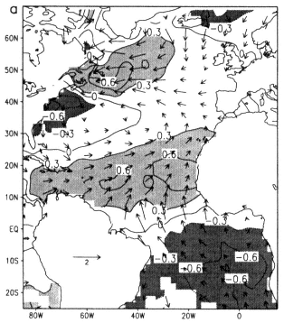
Figure 5-21
Basin-wide annual-average SST (ºC) and wind-velocity (m s-1) anomalies for six
years of high (1969,1970, 1978, 1980, 1981, 1982)and six of low (1972, 1973, 1974,
1984, 1985, 1986) Tropical Decadal Oscillation index (defined as the difference in
SST between 10-20ºN and 15-5ºS). (From Xie and Tanimoto, 1998; reprinted with permission
of the American Geophysical Union.)
in the sections below. The Atlantic Ocean has a longer history and greater density of measurements (especially the North Atlantic) than any other ocean basin, so some examples drawn from this basin may have analogs in other basins that have not yet been detected.
The Atlantic Ocean
SST is known to vary coherently on dec-cen time scales in the Atlantic. In the North Atlantic, the time scale of the cold and warm epochs that coincide with longer-term variations of the North Atlantic Oscillation (NAO) is relatively long, on the order of multiple decades (see, for example, the pattern shown earlier in Figure 3-5). In the subtropical Atlantic, the north-south dipole mode has a time scale closer to a decade (see, e.g., Mehta and Delworth, 1995). It has recently become clear that the variability in the North Atlantic co-varies with the subtropical dipole, and an Atlantic-wide oscillation may be present; Figure 5-21 shows the basin-wide connection between these modes (Xie and Tanimoto, 1998). This basin-wide banded pattern also correlates strongly with rainfall in northeast Brazil. Hansen and Bezdek's (1996)

Plate 1
Annual surface temperature in ºC for 1975-1994 relative to 1955-1974. (From IPCC, 1996a; reprinted with permission of Intergovernmental Panel on Climate Change.)

Plate 2
The global distribution of upper-ocean flow, which is primarily wind-driven. (From Schmitz,
1996; reprinted with permission of the Woods Holes Oceanographic Institution.)

Plate 3
Schematic of the global thermohaline circulation. (From Schmitz, 1996;
reprinted with permission of the Woods Hole Oceanographic Institution.)

Plate 4
Climate change in the Peruvian Andes. Upper part, a map of the changes in extent of the tropical
glacier Qori Kalis from 1963 to 1995, with photographs of the change over 8 years. The left-hand
graph relates the shrinkage of Qori Kalis to the rising temperatures indicated by the ice-core data
below it. Lower part, oxygen-isotope values from a Huascaràn ice core. Bottom panel, century
averages; top panel, annual averages since 1900. (After Thompson et al., 1995; reprinted with
permission of the American Association for the Advancement of Science.) (Figure courtesy of Lonnie
G. Thompson, Byrd Polar Research Center.)

Plate 5
Precipitation trends over land, 1900-1995. The trend is expressed in percent per century relative to the mean
precipitation from 1961-1990. The magnitude of the trend at each location is reflected in the size of the circle.
Green circles represent increases in precipitation, and brown circles represent decreases. (From IPCC, 1998;
reprinted with permission of the Intergovernmental Panel on Climate Change.)

Plate 6
Estimates of the globally and annually averaged anthropogenic radiative forcing (in W m-2) attributable to changes in
concentrations of greenhouse gases and aerosols from pre-industrial times to the present day, and to natural changes
in solar output from 1850 to the present day. Error bars are shown for all forcings. The indirect effect of sulfate aerosols
through their interaction with clouds is so uncertain that no central estimate of radiative forcing is provided. (From IPCC,
1996a; reprinted with permission of the Intergovernmental Panel on Climate Change.)
Page 83
and Sutton and Allen's (1997) analyses of SST indicate that the warm/cold epochs of Kushnir (1994) involve systematic interannual-to-decadal propagation of winter SST anomalies along the primary circulation pathways in the North Atlantic, which suggests an interplay between ocean dynamics and sequestering of temperature information (making it unavailable to the atmosphere) in the upper ocean.
Because salinity is not routinely measured, it is much harder to assess the decadal variability of sea surface salinity than SST. There is, however, a well-known low-salinity event that was observed over much of its 20-year lifetime. Referred to as the Great Salinity Anomaly (GSA), it was first observed in the Labrador Sea in 1968, and peaked in 1971 (Dickson et al., 1988). The GSA migrated out of the Labrador Basin and flowed eastward in the southern subpolar gyre and merged with the cold subtropical gyre, before reappearing again around Greenland and the Labrador Basin in the early 1980s. The origin or the GSA is thought to lie in the increased discharge of ice through Fram Strait and its subsequent melting, although this theory is still a source of debate.
Temperature variations have also been documented below the surface. Figure 5-22 shows the 500 m temperature difference between two 5-year averages (pentads) 15 years apart (Levitus, 1989). Differences of more that half a degree are clearly seen. Similar results have been found in two deeper surveys (Roemmich and Wunsch, 1984; Parilla et al., 1994). Also, the heat content of the upper ocean near Bermuda appears to have increased since the 1970s, and the thermocline to have moved correspondingly (Joyce and Robbins, 1996). These observations reflect interdecadal changes in both the properties and the volume of the upper water mass, in response to changes in the dynamics (wind forcing and associated thermocline response, or ''heave") and thermodynamics (surface buoyancy flux and associated convection). For example, there is a cooling of the dominant regional convective water mass, known as 18ºC water, from the mid-1950s to about 1970, and then a warming till the mid- 1990s. The cooling and warming are in phase with those in the Greenland-Iceland-Norwegian (GIN) Seas, and opposite in phase to those in the Labrador Sea and the NAO (Dickson et al., 1996).
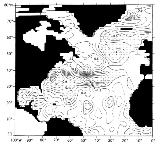
Figure 5-22
Temperature differences (in ºC) for 1970-1974-1979 minus 1955-1959 at 500 m in the North Atlantic.
Dot shading indicates negative values. (From Levitus, 1989; reprinted with permission of the American Geophysical Union.)
Page 84
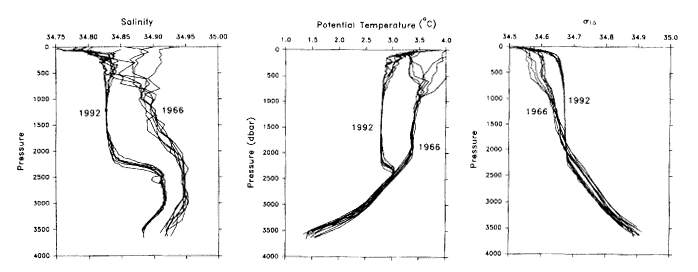
Figure 5-23
Temperature and salinity profiles obtained at six stations in the central Labrador Sea in March
1966 and in June 1992. Left, profiles of salinity; center, profiles of potential temperatures; right,
profiles of density referenced to 1500 db. (From Lazier, 1995; reprinted with permission of the
National Academy Press.).
Warm, salty water proceeds northward in the Gulf Stream, cooling as it crosses the Atlantic in a northeastward direction as the North Atlantic Current. Upon reaching the subpolar regions, it enters the GIN Seas and then spreads into the Arctic, where it mixes with resident water masses and further increases in density due to additional cooling and salinization associated with sea-ice formation. It eventually sub-ducts and/or convects and flows back out of the GIN Seas at intermediate depths, whereupon it sinks to depths of several thousand meters and proceeds southward as a deep cold boundary current beneath the Gulf Stream. This deep western boundary current is joined in its upper parts by convecting water from the Labrador Sea. Any variation in convection in the source regions of the THC will be reflected in changes in transport, and may therefore affect subsurface regions along the pathway of the deep boundary current, and the sea surface to which the water eventually returns.
Decadal-scale water-column alterations in the Labrador Basin (Figure 5-23) have been documented through repeated sections, surveys, and time-series station observations (e.g., Lazier, 1995). The downstream effects on circulation (McCartney et al., 1997) and ventilation (Molinari et al., 1997) have been observed in the western North Atlantic. Figure 5-23 shows that convection was more intense and deeper in 1992 than in 1966. A time series of the temperature of Labrador Sea Water (LSW), shown in Figure 5-24, reveals the interdecadal nature of its history (McCartney et al., 1997). The temporal evolution of the NAO is also illustrated in Figure 5-24; generally it varies inversely with the
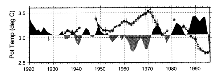
Figure 5-24
LSW temperature time series with NAO overlay. (From McCartney et al., 1997.)
Page 85
interdecadal progression of the LSW. It has been suggested (Dickson et al, 1996) that the NAO has large-scale effects on convection in the Greenland Sea, which showed a remarkable reduction in the 1980s (Schlosser et al., 1991). There is also evidence that the Labrador Sea was affected by the passage of the GSA in the late 1960s, undergoing reduced convection and subsequent warming.
A few measurements document interdecadal variability in the Southern Hemisphere deep and bottom water-formation regions. While the changes observed are small, they are significant in that they involve vast quantities of water, and therefore must be related to large-scale persistent changes in the environment at the air-sea interface (see, e.g., Coles et al., 1996; Zenk and Hogg, 1996). An abyssal warming and a decline in bottom-water transport were observed in 1992-1994 at the equator at the northern end of the Brazil Basin; the temperatures involved were all lower than measurements made in the same location in 1972, 1983, and 1989, however, suggesting recovery from some intervening cold event (Hall et al., 1997). Hall et al. also found a pronounced seasonal cycle in the deep circulation. This rapid cycling suggests that the deep limb of the THC is less isolated from higher-frequency forcing than might be expected, and that perhaps in the tropics the behaviors of the deep/cold and shallow/warm limbs of the THC are dynamically coupled.
A variety of evidence from Greenland ice cores and ocean sediments has been used to suggest that the patterns and rates of deep oceanic circulation have undergone large changes over the past several hundred thousand years (see, e.g., Broecker and Denton, 1989). These changes have been interpreted to be the result of the recurrent cessation and initiation of the Atlantic thermohaline circulation. While the changes associated with the glacial stages reflect millennial-scale change, recent analyses indicate that some of the more abrupt events in these ice and sediment cores reflect changes that may have taken place in a matter of decades or less (see, e.g., Severinghaus et al., 1998; Grootes, 1995).
It is unclear what mechanisms are responsible for initially triggering these ocean-atmosphere reorganizations. Substantial increases in iceberg calving, inferred from deep-sea sediment cores, have recurred at intervals of 2,000 to 10,000 years. These phenomena, known as Heinrich events, have been related to circulation changes in both high-latitude and equatorial regions (McIntyre and Molfino, 1996). They have been correlated with warm/cold climate oscillations known as Dansgaard-Oeschger events (Bond and Lotti, 1995). Analyses of deep-sea cores from the North Atlantic suggest that abrupt shifts in climate occur independently of the glacial-interglacial fluctuations on a millennial-scale cycle; they have been inferred to exist from at least 500,000 years ago through the Holocene (Bond et al., 1997; Oppo et al., 1998). Evidence from both poles indicates a high level of global synchronicity in some of these abrupt climate changes (Bender et al., 1997), though the degree of synchroneity is still controversial for some of the shorter time-scale events. Date derived from ice cores indicate that Antarctic climate changes often precede those in Greenland by more than 1,000 years (Blunier et al., 1997, 1998).
While attempts have been made to reconstruct the SSTs that existed during the last glacial maximum (CLIMAP, 1981), much of our understanding of the ocean-circulation patterns that may have existed during periods when ocean circulation was different from the present (e.g., the last glacial maximum) comes from modeling studies (e.g., Mikolajewicz et al., 1997; Bush and Philander, 1998). For instance, the study by Mikolajewicz et al. (1997) using a coupled ocean-atmosphere GCM suggests that a shutdown of North Atlantic Deep Water formation during the Younger Dryas (approximately 12,000 BP) may have also brought about a cooling in the North Pacific. Paleo-proxy data support such a link between the Atlantic and Pacific (Broecker and Denton, 1989). Among the other mechanisms that have been proposed to account for such large-scale changes in climate regime are the onset of a large-amplitude internal mode of oscillation in thermohaline circulation (Tziperman, 1997; Weaver and Hughes, 1994), and a non-linear response to gradual changes in solar insolation resulting from changes in the Earth's orbital parameters (Herbert, 1997). It has also been suggested that the warming from increased atmospheric greenhouse-gas levels could lead to a significant reduction in THC (Manabe and Stauffer, 1994). Stocker and Schmittner (1997) found that the degree to which the thermohaline-circulation rate can decrease depends on the rate of increase in atmospheric greenhouse gases. Their coupled ocean-at-mosphere model indicates that if the warming is rapid enough, deep-water formation in the North Atlantic may effectively cease.
The study of abrupt climate change began relatively recently, and it is not yet fully understood, but the observational evidence is tantalizing in that it suggests the possibility that major climate shifts may occur over relatively short time scales. This possibility underscores the need to improve our understanding of the sensitivities of climate to changes in the thermohaline circulation, and the dependence of the thermohaline circulation on changes in its source areas.
The Pacific Ocean
Examination of the zonally averaged circulation in the Pacific reveals a shallow meridional overturning cell that connects the tropics and subtropics (Hirst et al., 1996). This overturning involves equatorial upwelling, poleward flow near the surface, subduction in the subtropics, and equator-ward return flow in the upper part of the thermocline (the band where there is a strong thermal gradient). Forced by both Ekman (wind-driven) pumping and thermocline fluxes
Page 86
(see, e.g., McCreary and Lu, 1994), this overturning cell helps determine equatorial SSTs, the amount of tropical heat exported to the subtropics, and thermocline stratification throughout the region. Variability of each of these processes is likely on all time scales.
The dominant SST variations in the Pacific Basin were discussed in Chapter 3 (see Figures 3-6 through 3-9). The dec-cen pattern shown in Figure 3-8 has a broader meridional SST-anomaly pattern in the tropics than the ENSO pattern shown in Figure 3-6, and has clearly stronger values of mid-latitude SST relative to the tropical (ENSO) values. Thus, the analysis representative of longer time scales (Figure 3-8) indicates that the equatorial and mid-latitude regions contribute comparably strong anomalies, and that the regional contributions to climate are greater in geographical extent than the contributions from interannual-scale variability. The time coefficient of the interdecadal pattern in Figure 3-8 exhibits "regime shifts" in 1976 (Trenberth, 1990). Since the mid-latitude manifestation of this mode is so strong, it can be identified with a specifically North Pacific oscillation now called the Pacific Decadal Oscillation (PDO). The PDO can be identified from the pattern illustrated in Figure 3-8 or obtained by direct EOF analysis of North Pacific SST (see Mantua et al., 1997).
The PDO index, shown in Figure 5-25, co-varies with an index of pressure over the North Pacific. When the water over the North Pacific (Figure 2-18) is cold (as it has been since 1976), the Aleutian low is deep and the PNA pattern is
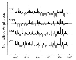
Figure 5-25
Normalized winter mean (November-to-March) time histories of Pacific climate indices.
Dotted vertical lines are drawn to mark the PDO polarity reversal times in 1925, 1947, and
1977. Positive values of the NPPI (North Pacific SLP) correspond to years with a deepened
Aleutian low. The negative SOI is plotted so that it is in phase with the equatorial SST
anomalies captured by the cold-tongue index (CTI). Bars with positive values are filled
with black, those with negative values with grey shading. (From Mantua et al., 1997;
reprinted with permission of the American Meteorological Society.)
strong. There is a definite correlation between the PDO and the salmon catch in the mid-latitude North Pacific (Mantua et al., 1997) and, in particular, between the 1976 Pacific climate-regime change and fish migration patterns (Mysak, 1986). As is seen in Figure 5-25, the regime shifts in mid-1976 also manifest themselves in several other ways: as an increase in tropical SST indicated by the Southern Oscillation Index (see also Graham, 1994); as a change in subsurface conditions in the tropical (Guilderson and Schrag, 1998) and mid-latitude Pacific ( Zhang and Levitus, 1996); and as an increase in the intensity and regularity of warm phases of ENSO. While the temporal character of interdecadal variations cannot clearly be defined from the record shown in Figure 5-24 (it begins only in this century), Minobe (1997) has extended the PDO record using tree-ring records from North America; he deduces a time scale of 50-70 years for the variability. Because EOF methods do not cleanly separate time scales, studies based on such analyses have reported characteristic time scales ranging from interannual to 70 years. Until the record is extended, this limitation will probably persist.
While changes in surface temperature are obviously important, it is the combination of temperature and salinity that dictates the density profile and thus much of the vertical redistribution of enthalpy, freshwater, and momentum. These factors influence not only the magnitude of surface-temperature anomalies, but also the speed and structure of the ocean currents, and thus the lateral redistribution of any anomalies. The vertical structure of anomalies and currents will vary according to the relative phasing of the temperature and salinity signals, with implications for the evolution of other ocean-atmosphere phenomena over a variety of time scales. The importance of the relative phasing of temperature and salinity implies that the regional response to an E1 Niño event may differ from year to year.
Deser et al. (1996) have related decadal-length SST records to upper-ocean temperature changes and to zonal-wind anomalies (Figure 5-26). The subsurface temperature data provide clear evidence of variability across a range of interannual to decadal time scales; it becomes increasingly decadal with depth. Also, Deser et al. (1996) and Watanabe and Mizuno (1994) suggest that water subducts from the high-latitude cold pool into the subtropical gyre of the North Pacific on time scales of a decade or more. Analysis of tracer-derived ages shows that water subducted into the eastern North Pacific subtropical gyre can be transported on decadal time scales into the equatorial Pacific (Fine et al., 1987), and that those waters can be found beneath the warm and cold pools associated with ENSO. Furthermore, these tracer data can be used to infer that the loop back to the surface for the subducted water is closed by upwelling at the equator (Jenkins, 1998). In an analysis of temperature observations, Zhang et al. (1998) find that the Pacific upper-ocean warming and decadal changes in ENSO after 1976 may have their origin in changes in higher latitudes that have propagated
Page 87
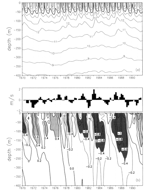
Figure 5-26
Time-depth plot of seasonal (a) total and (b) anomalous temperature in the central North Pacific region. In (a) the
contour interval is 1ºC and the 15ºC contour is thickened. In (b) the contour interval is 0.2ºC, negative anomalies
are dashed, and anomalies greater than 0.4º (less than -0.4ºC) are indicated by light (dark) shading. The bar graph
directly above (b) shows seasonal zonal wind anomalies; positive (negative) values denote stronger (weaker) than
normal winds from the west. (From Deser et al., 1996; reprinted with permission of the American Meteorological Society.)
equatorward via subsurface transport. These dynamics have been illustrated in various ocean-only models (e.g., Liu et al., 1994), and demonstrated in an ocean assimilation model, where the assimilation of observed temperature data at high latitudes generates decadal variability in equatorial regions (Lysne et al., 1998).
The Indonesian Seas are the only warm-water pathway between ocean basins. By transporting anomalies between basins, the Indonesian throughflow plays an important role in climate variability. Gordon and Fine (1996) find seasonal (monsoonal) variations in the ratio of North and South Pacific water contributing to the throughflow of water to the Indian Ocean. They conclude that the ratio changes in response to the phase of ENSO, and may provide feedback to ENSO by influencing the extent of the warm pool in the western equatorial Pacific. The tropical biennial oscillation
Page 88
and ENSO have been linked to the Asian-Australian monsoon system. In addition, Allan et al. (1995) find significant interdecadal SST anomalies in post-1900 Indian Ocean data. Reason et al. (1996a,b) suggest that the principal explanation for the mid-latitude decadal SST anomalies is found in equatorial wind anomalies from the Pacific, which drive variations in the Indonesian throughflow, resulting in variations in the Agulhas Current.
Other changes in the North Pacific subtropical gyre have been deduced from brief records. Qiu and Joyce (1992) found a gradual increase in the Kuroshio and North Equatorial Current transport of about 5 sverdrups (1 Sv = 106 m3/s) per decade, starting in 1970 and continuing into the 1980s, which implies greater wind forcing. Bingham (1992) showed that during the period 1978-1982 the subtropical gyre was stronger than during 1938-1942, which again implies greater wind forcing. Deser et al. (in press) found an intensification of the winds associated with the regime shift of 1976, and showed that the enhancement of the Kuroshio was part of a general North Pacific response to this wind shift. The pattern of decadal variability of the winds, including those winds connected with the 1976 shift, can be seen in Figure 3-8.
The Southern Ocean
Constructing an image of subsurface variability in the South Atlantic, South Pacific, and southern Indian Ocean is more difficult than in the northern oceans, because of the relative paucity of hydrographic data and the lack of meteorological data in the high-latitude Southern Hemisphere. Despite this scarcity, several studies have been able to glean evidence of decadal-scale variability from what data are available.
Changes in temperature and salinity of similar magnitude to those reported in the deep North Atlantic Ocean (Bryden et al., 1996) are also seen in Subantarctic Mode Water and Antarctic Intermediate Water in the Tasman Sea (Bindoff and Church, 1992), the South Pacific (Johnson and Orsi, 1997), and the southern Indian Ocean (Bindoff and McDougall, in press). The trend towards cooling and freshening on isopycnals and warming on depth surfaces is coherent over a large spatial scale between the late 1960s and early 1990s, but the long time elapsed between surveys may mean that the measurements are not strictly comparable. The changes are consistent with surface warming at high southern latitudes and surface freshening in higher southern latitudes at some time during the two decades that elapsed between the repeat hydrographic sections (Bindoff and McDougall, 1994). There is also evidence of changes in the Weddell Deep Water (Fahrbach et al., in press), though the records are not yet long enough to fully characterize the time scales of the variability.
The Antarctic Circumpolar Wave (ACW), described in Chapter 3, is a traveling-wave disturbance in SST, SLP, sea ice and surface winds (White and Peterson, 1996). It is predominantly interannual in nature, but it displays a longer-scale component in the relatively short record documenting it. While distinct in the Southern Ocean circumpolar belt, this phenomenon may be global in scope and involve linkage to ENSO (Barnett, 1985; White and Peterson, 1996; Tourre and White, 1997; Yuan et al., 1996), though some argue that it is primarily a regional phenomenon (e.g., Qiu and Jin, 1997). The ACW signal is large in the higher-latitude sectors of the Southern Hemisphere; its impact may influence intermediate- and deep-water formation, which may in turn alter the thermocline characteristics of the subtropical gyres, influencing lower-latitude properties and spreading the ACW influence to broader spatial and temporal scales.
Even less is known about low-frequency atmosphere-ocean interactions in the South Atlantic. Kushnir et al. (1998) show correlated NAO, SST, and SLP signals in the tropical Atlantic and parts of the South Atlantic. Barnett's 1985 study of global SLP indicated NAO-related SLP signals in these South Atlantic areas as well, but with a time delay: The high (low) SLP there follows the high (low) NAO states. An analysis of transports in the upper waters of the southeast Atlantic from 1993 to 1995 suggests that the observed variability is related to gyre wobble, rather than to changes in gyre intensity (Garzoli et al., 1997).
Mechanisms
Global Ocean Processes
Climatically relevant oceanic variability is manifested in many ways, among them anomalies of SST, salinity, sea ice, and the underlying internal distribution of heat and salt content, as well as changes in the patterns and intensities of oceanic circulation. The ocean's participation in climate-change phenomena can be essentially passive—the ocean merely responds to forcing by an evolving atmosphere—or it can be active—variability in air-sea exchange and subsequent sequestration and redistribution of heat, freshwater, and carbon dioxide feed back to affect the evolution of the overlying atmosphere. Active participation can be seen as primarily a cause-and-effect relationship, in which some internal natural mode of variability in the ocean forces an atmospheric response, or as a coupling, in which changes in ocean and changes in atmosphere mutually reinforce or oppose each other.
The vast thermal, kinetic-energy, and chemical capacities of the ocean, by comparison with those of the atmosphere, generally make the ocean a much more slowly changing element of the system, and thus a potential modulator of the fast-responding atmospheric-circulation system. But that slow modulating role may be only partially realized at any given time, because the strong vertical stratification of the water insulates much of the ocean's volume from direct in-
Page 89
teraction with the atmosphere. In many regions, the impact of air-sea exchanges on the ocean is restricted to a relatively thin near-surface layer whose smaller storage capacity allows a faster response. Indeed, on seasonal and interannual time scales the oceanic response to atmospheric change is essentially in phase, reflecting a more local balance of the heat budget on these short time scales. For example, the observed strong correlation between SST tendency and the amplitude and sign of local heat-flux anomalies is to a first approximation a ''passive ocean" response of the local mixed layer to atmospheric forcing. This is not the case on longer time scales, where the ocean transport of anomalies alters the heat balance and thus the phasing (and even direction) of the atmospheric change.
The large mass of the ocean compared to that of the atmosphere allows the relatively sluggish ocean to be comparably effective in its redistribution of properties, especially heat. Poleward transport of heat within an ocean basin is achieved when the aggregate of poleward flows at a given latitude in a basin is warmer than the aggregate of equatorward flows. The slow-moving THC involves large surface-to-deep-water temperature differences, so the amount of heat it transports meridionally is similar to that transported by the faster-moving wind-driven circulation.
In addition to the THC's storage and redistribution of heat, and the global movement of heat from the equator to the poles, there is also a basin-scale influence associated with the lateral redistribution of heat that is important on longer time scales. On short time scales, such as the seasonal-to-interannual, the local storage of surface heat is balanced predominantly by vertical diffusion; on longer time scales, however, the rate of change of surface temperature represents a balance between lateral advection and diffusion (Moisan and Niiler, 1998). That is, on longer time scales, surface anomalies are displaced laterally by the slow but steady movement of the ocean' s surface currents. This lateral redistribution of heat typically swamps any local heat-storage imbalance.
This power of the ocean's heat transport is particularly evident in the climate system. For example, the oceanic meridional transport of heat northward across 24ºN (the aerial midpoint between the equator and pole) is estimated directly from oceanic measurements to be about 2 petawatts (PW; Bryden et al., 1991). This figure represents about half of the net meridional heat transport required by the Earth's radiation budget at this latitude, suggesting that the contributions of atmospheric and oceanic circulation to the overall budget are nearly equal (Trenberth and Solomon, 1994). At 24ºN, the North Pacific and North Atlantic together span only a bit more than half the Earth's circumference, so the ocean is about twice as effective (per unit of longitude) as the atmosphere in transporting heat meridionally at that latitude. The mean currents are responsible for most of the heat transport in the ocean with the transient eddies contributing comparatively little.
Of the ocean's contribution to meridional heat transport, 1.2 PW occurs in the North Atlantic and 0.8 PW in the North Pacific (Bryden et al., 1991). The North Atlantic is only half the width of the North Pacific, and spans about a fifth of the Earth's circumference, so it is three times as effective (per unit longitude) as the North Pacific (and more than three times as effective as the atmosphere) in transporting heat meridionally at 24ºN. This contribution is so strong because the North Atlantic is the dominant Northern Hemisphere site for conversion of warm water to cold water within the THC. The North Pacific also converts warm water to cold, but achieves less poleward heat transport because the warm-to-cold-water conversion occurs primarily above the thermocline and undergoes a smaller effective temperature change than the deep-reaching overturning in the North Atlantic. The Indian Ocean also supports large poleward heat transport through a deep-reaching overturning circulation with a large effective temperature change.
The ocean's redistribution of freshwater is a dominant agent in the hydrologic cycle. It compensates almost completely for the meridional transport of water vapor in the atmosphere. The remainder of the contribution from river flow is approximately an order of magnitude smaller. There are significant differences in the patterns of net water flux into the various ocean basins. For instance, the North Pacific receives much more precipitation than the North Atlantic. As a result, the North Pacific is a fresher ocean that does not support deep-water formation or a significant thermohaline circulation, as previously mentioned. This limits the amount of heat it can carry through its large volume of deep water, although its large basin is involved in considerable movement of surface anomalies over broad distances. The more saline Atlantic, in contrast, has sites of both deep- and inter-mediate-water formation and maintains a vigorous thermohaline circulation, permitting greater meridional heat transport.
Understanding the linkages between heat and freshwater transport in the ocean is a fundamental requirement for solving many of the puzzles of climate variability. In addition to modulating oceanic heat transport and density distribution (which influences currents and the volume of surface water with which surface fluxes interact), the differences in net water flux into the various ocean basins also lead to interbasin flows, such as that through the Bering Strait. Thus, the net southward flow of 0.3 Sv at 24ºN is the difference between a large southward flux in the North Atlantic and a smaller northward flux in the North Pacific (Schmitt and Wijffels, 1992). This net southward flow compensates for the net atmospheric transport of water vapor from the Atlantic to the Pacific (Broecker, 1991). Therefore, the latent heat flux associated with this atmospheric water-vapor transport can be indirectly estimated from oceanic mass flux, which permits the magnitude of two major components of meridional heat transport (i.e., oceanic advective heat flux and at-
Page 90
mospheric latent heat flux between the Atlantic and Pacific) to be determined from ocean data alone.
The net meridional transports of water, discussed above, are dwarfed by the large evaporation and precipitation fluxes over the ocean; some 12.6 Sv of water is thought to be precipitating on to the ocean, nearly 4 times the water that is falling on land. The net excess of terrestrial precipitation over evaporation is returned to the sea by rivers at a rate of more than 1 Sv (see, e.g., Berner and Berner, 1987). Thus, the largest portion of the global water cycle occurs over the oceans, where it is poorly known, but appears to have significant impact on oceanic climate processes (e.g., the GSA) and on surface freshening and stabilization. Small redirections of the water transports from ocean to land could have dramatic consequences. For example, an increase in precipitation over the Mississippi River basin equivalent to a mere 1 percent of Atlantic precipitation would more than double the discharge of the Mississippi River. Expanded measurements of oceanic salinity fields are required to better constrain our estimates of the oceanic water cycle's fluxes and reservoirs, as well as its role in climate fluctuations.
The ocean sequesters a great amount of carbon dioxide, and thus is a major consideration in estimating the ultimate fate (and buildup) of anthropogenic carbon dioxide in the atmosphere, and the resulting increases in greenhouse warming. The oceanic inventory of carbon is estimated to be 39,000 gigatons (Gt), with the deep ocean containing over 95 percent (IPCC, 1995). This quantity is more than 50 times the atmosphere's inventory, and about 18 times the amount contained in terrestrial biota and soils (IPCC, 1995). The ocean' s inventory is growing at a rate of approximately 2 Gt per year, which corresponds to roughly one-quarter to one-third of the rate of release of carbon to the atmosphere by all current anthropogenic sources of carbon dioxide. The ocean is thus a major carbon reservoir, capable of moderating the growth of carbon dioxide in the atmosphere and redistributing that carbon globally. Therefore, by influencing the concentration of atmospheric CO2, the oceans indirectly affect the Earth's radiation budget and the overall energy balance of the climate system.
The components of the global carbon budget are not as firmly established as those of the heat and freshwater budgets. The IPCC (1995) places error limits (with 90 percent confidence) of 0.8 Gt per year on the 2.0 Gt per year best estimate of net oceanic carbon uptake. The ocean absorbs CO2 by two mechanisms: the solubility pump (effectively the ability to hold more or less CO2 as water cools or warms), and the biological pump (the biological incorporation of carbon into living cells and its ultimate transfer to deep water after cell death). These two pumps are discussed in greater detail in the "Atmospheric Composition and Radiative Forcing" section earlier in this chapter. Feedbacks associated with changes in ocean dynamics and thermal composition over local, regional, and global scales increase the uncertainty in predicting future oceanic uptake. These feedbacks involve complex interactions between physical and biogeochemical processes operating over a broad range of scales.
For example, the study by Sarmiento et al. (1998) investigating the role of the ocean in modulating the anthropogenic increase of atmospheric CO2, identifies the Southern Ocean's circumpolar region as the region showing the most sensitivity to different model formulations while having the largest global impact on the net atmospheric CO2 concentration. Sarmiento et al. (1998) suggest that the effectiveness of the circumpolar region in CO2 uptake, which is a function of the biological and solubility pumps, is enhanced by strong isopycnal mixing that tends to efficiently transport (subduct) the freshly absorbed CO2 from the surface layer into the deep waters to the north, strengthening the solubility pump. As atmospheric CO2 increases, their model freshens the circumpolar region, which stabilizes the surface layer. This stabilization reduces the subduction, decreasing the effectiveness of the CO2 uptake via the solubility pump. The stabilization also reduces the upward mixing of deep nutrients into the surface layer. This might in turn alter the biological productivity and effectiveness of the biological pump; however, the biological formulations in the model used by Sarmiento et al. were not designed to quantify the likely changes in productivity. In contrast to indications in the Sarmiento et al. study that the biological pump might be significantly affected by climate-induced changes in the ocean, the modeling study by Maier-Reimer et al. (1996) suggests that feedbacks involving changes in the biological pump might be relatively minor in importance.
Keeling and Peng (1995) estimate that the North Atlantic Ocean takes up and transports about 0.4 Gt of carbon per year across the equator into the Southern Hemisphere. Keeling et al. (1996b) show that atmospheric oxygen concentrations in the Southern Hemisphere are currently higher than in the Northern Hemisphere. A consistent explanation for this interhemispheric gradient can be given by a combination of factors: More fossil fuel is burned in the Northern Hemisphere (releasing CO2 and consuming O2); terrestrial ecosystems in the Northern Hemisphere are likely a net CO2 sink (and source of O2); and net transport by the Atlantic Ocean is southward. Thus, the Keeling et al. result is broadly consistent with the Keeling and Peng (1995) result for oceanic carbon transport in the Atlantic. Little is known about oceanic carbon transports in the Indian or Pacific Oceans.
Observations of oceanic uptake and transport of anthropogenic CO2 (see, e.g., Gruber, 1998) can be used to assess the veracity of ocean GCMs. A recent study by Stephens et al. (1998) using this approach concludes that the models they examined tend to take up too much anthropogenic CO2 in the Southern Ocean, and therefore do not accurately repro-
Page 91
duce the interhemispheric transport of carbon and oxygen that is seen from or implied by atmospheric observations.
Local Ocean Processes
For longer time scales, for some regions, and for some climatic phenomena, the ocean is not simply a well-mixed layer passively responding to flux anomalies forced by the atmosphere. The ocean may also have active modes of internal variability that force an atmospheric response, or participate actively in coupled ocean-atmosphere modes of variability on the dec-cen time scale. The ocean's active role in dec-cen climate variability involves several local mechanisms.
First, the ocean acts as a recorder and integrator of the forcing history—the farther downstream along the paths of surface or thermohaline circulation, the older the record. By subducting parcels of water containing climate information reflecting a particular time, and later returning them to the surface, the THC temporally translates climate conditions and influences the evolution of future climatic changes. (This record of past climate, manifested in the temperature and chemistry of the water, is also a valuable scientific tool that can provide insight into the history of climatic processes on the time scale of years to many centuries.) For example, the relatively deep-reaching convection in the northern North Atlantic, which typically extends down to 500 m but often attains depths exceeding 1000 m, provides an advective memory. A heat anomaly spanning the thermacline—for example, warm/cold 18ºC water atop an unusually deep/ shallow thermacline—can "remember" and preserve a residual influence for great distances, not just through a seasonal sequestering cycle, but through many years of recurrent sequestering and re-exposure. McCartney et al. (1997) show that the anomalies that arrive in the area west of Ireland 10 years after their initiation in the western subtropical gyre are not dissipated there. They not only propagate northeastward in the Norwegian Current, but move west across the subpolar gyre to the Labrador Basin, contributing a 20-year-old "memory" to the warming and cooling cycles of the LSW.
A second mechanism important to dec-cen variability is the subduction or detraining of mixed-layer water conditions into the thermacline in some regions. This process reorganizes the vertical stratification on which the wind-driving of the circulation and the surface thermodynamic forcing act. Subduction alters both the advection fields and the distribution of the properties on which advection acts, thus modifying the ocean' s redistribution of heat, freshwater, and carbon dioxide. This sequestering of mixed-layer water is central to the ocean's active role in climate variability. Subsurface alteration continues at the same time that the advecting waters are isolated from the mixed layer through stirring by eddies and mixing. Also, all these subsurface changes are reflected in the near-surface field of currents in which the surface mixed layer and Ekman layers (i.e., layers affected by wind stress) reside. These deeper conditions, along with dynamic thermocline adjustments, therefore contribute to local SST variability through advection. While the "flushing time" by subduction in the subtropical thermocline appears to be interdecadal, the structural changes in subtropical circulation are significant decadally and in some areas interannually (see, e.g., Jenkins, 1998). Subduction represents the annual average of the seasonal cycle of buoyancy forcing and wind forcing of Ekman layers and gyre circulations. The nature of that seasonality is such that waters imprinted with winter conditions are selected for sequestering. The subduction mechanism was recognized early (e.g., by Iselin, 1939). The existence of some sort of selection process has also been suspected for some time, because the temperature and salinity characteristics observed at depth in subtropical gyres most closely resemble winter mixed-layer properties, rather than the variety of other waters that exist throughout the seasonal cycle at the sea surface. This selection bias was noted by Stommel (1979); it has been called his "mixed-layer demon."
Third, the ocean's active role in dec-cen variability is also manifested through the process of re-entrainment of subsurface waters into the mixed layer, after a period of sequestering, so that the stored properties like heat content are re-exposed through the mixed layer to air-sea exchange. The period of sequestering may be very long—-on the time scale expected for water moving along with the THC, or the time required for a parcel subducted into the subtropical gyre to circle the gyre and find its way to a place where accumulated buoyancy forcing re-exposes it to the atmosphere. In the case of "abduction" (Qiu and Huang, 1994), the sequestering can be seasonal: A mixed layer becomes capped by a seasonal thermocline, and is carded downstream during the warm season. During the cold season, the cap erodes, re-exposing the sequestered mixed layer. When the mixed layer is cooled further by its re-exposure, additional water is entrained into it from below.
The most easily recognized example in which subduction and abduction occur is the formation of "mode waters," which involves deep winter convection. The subduction process to a large degree preserves the extraordinary vertical homogeneity found in winter, to the extent that a tapered wedge extends equatorward from the winter outcrop, following the subtropical-gyre circulations.
Internal Ocean Variability Mechanisms
There are a number of interactions internal to the ocean that imply dec-cen variability without the participation of the atmosphere at all; they have been simulated in ocean models where the atmospheric forcing is kept constant. While these are, of course, subject to the criticism that the atmospheric response could change the variability, they illustrate the role of purely oceanic interactions in inducing variability.
Page 92
Most of the ocean-only mechanisms that have been reported involve anomalies that reach water-formation regions and change the density, thereby affecting the rate of deep-water formation. Weaver and Sarachik (1991) and Chen and Ghil (1996) found purely advective mechanisms for this sort of decadal variability. The weakening (or strengthening) of deep-water formation can induce changes in circulation that may counteract an anomaly or reverse it. Longer-time-scale (centennial) oscillations (see Weaver et al., 1993, or Winton and Sarachik, 1993) were found to originate from the shutoff of deep water, and the entire THC, by strong freshwater fluxes at the surface. The THC returns when heat diffusion warms the deep water enough to produce an unstable high-latitude column, and convection is re-initiated. The time scales on which these processes occur in models can range from centennial to millennial, depending on the parameters involved (especially diffusion of heat).
A number of climate variability mechanisms involve coupling of the ocean and atmosphere in such a way that the ocean plays a dominant role. For example, the alteration of heat content and density structure at depth, because of the variability of the waters subducted from mixed layers in winter, has been suggested by Gu and Philander (1997) to be a mechanism for modifying the equatorial thermocline. These subsurface changes cause alterations in the coupled atmosphere-ocean ENSO oscillation; these lead to atmospheric changes at mid-latitudes, which then complete a feedback loop by affecting conditions in the subduction sites. A simple box model constructed by Gu and Philander (1997) found that this feedback loop caused interdecadal oscillations.
A thermodynamic mechanism for interdecadal dipole SST oscillations in the tropical Atlantic has been proposed by Chang et al. (1997). The cross-equatorial dipole of warm and cold SST anomalies can experience heat-flux anomalies that arise from and are sustained by wind-induced latent-heating anomalies. This positive feedback is countered by a negative feedback that is provided by the advection of heat by the south-to-north flow of the North Brazil Current, the principal cross-equatorial warm current of the THC. This current provides oppositely signed SST (heat-content) anomalies that reverse the atmospheric-circulation anomalies, and then remove the SST anomalies by reversing the evaporative heat-flux anomalies. An alternate mechanism to this cross-equatorial negative feedback has been proposed by Zhou (1996). He suggests that the negative feedback is provided by the action of altered winds, which produce SST anomalies that have opposite signs in lower and higher tropical latitudes. When these anomalies are advected by the surface circulation; they eventually restructure the atmosphere to yield anomalies with the opposite sign, again producing an interdecadal oscillation. Tourre et al. (in press) propose a third mechanism, involving flexure of the thermocline.
Predictability
Hopes for predictability of climate variations intrinsically involving the ocean are based on the slow responsiveness of the ocean relative to the atmosphere, as discussed in Chapter 4. Initialized prediction is based on the concept that once the ocean is set in motion, it will follow a predictable path. Loss of predictability will then be due to two basic factors: imperfect specification of the initial state, so that the initial errors inevitably grow, and random (unpredictable) eddy "noise" in the atmosphere and ocean that progressively contaminates the forecast as it evolves. At this writing, not much progress has been made on characterizing the relative effects of these error-growth mechanisms on decadal time scales. While predictability has been indicated (see Chapter 4), we know little about the ultimate limits of initialized predictability.
For the long-time-scale prediction of ocean evolution, we need improved understanding and modeling of the processes that transport heat in the ocean, the coupled processes that influence SST, and the divergence (net flux) of heat, freshwater, and CO2. We must improve our understanding of, and ability to model, how these processes vary in time and on local, regional, and global scales, and what their primary dependencies and interdependencies are. To do so will require improved treatment of the interactions between thermodynamic processes (e.g., those associated with boundary-layer fluxes) and dynamic processes. For example, a detailed representation of the mixed layer is required in order to model correctly the responses of upper-ocean SST to a given atmospheric heat flux; the model must be able to take into account vertical property fluxes, lateral property fluxes associated with lateral or isopycnal mixing (including the effects of eddies) and advection, and the proper response of the pycnocline (the band where there is a strong density gradient) to the surface wind-stress curl, which further affects surface water volume and stratification of the upper ocean.
One of the difficulties inherent in dec-cen predictions of ocean-circulation variations is that while we must include more and more of the ocean as we consider longer and longer time scales, we must still treat the small-scale processes as well. A great variety of disparate processes, operating over a broad range of spatial and temporal scales, must therefore be incorporated into predictive models. Performing long integrations over global space scales, while including detailed representation of local-scale processes (and in the case of the carbon system, multi-disciplinary processes), poses a considerable computational challenge.
For example, the thermohaline circulation's rate, volume, properties, and flow paths are sensitive to local-source region processes that control the location, depth, and rate of convection, and the extent of mixing during convection and subsequent flow. THC flow is also sensitive to the treatment of the boundary layer, which will influence the flow path
Page 93
and the mixing along that path, which in turn influence the THC's properties, equilibrium flow depth, and geographic displacement. Many of these local processes are sensitive to small variations in the vertical stratification and the evolution of the mixed-layer. These variations in turn are sensitive to regional-scale dynamic forcing, which influences vertical velocities and pycnocline characteristics such as depth and vertical spread; to surface buoyancy fluxes driven by turbulent and radiative forcings or by freshwater exchanges, which are often associated with the melt, drift, and decay of sea ice; and to the large-scale circulation systems and water-mass distributions that determine the property contrasts across the pycnocline, and the strength of the stratification. The regional-scale processes influence the duration of convection and the preconditioning for convection. If any of these details is incorrect, a model can introduce a small (or large) systematic error (i.e., drift) that can bias the results, or yield an evolution or set of balances that differ from those present in the real world.
Intermediate waters, which to a large degree constrain the upper ocean's volume, are influenced by detailed local processes: convection, confluence of surface waters with outcropping deeper isopycnals, and sea-margin processes. These marginal processes, exemplified by the production of North Pacific intermediate water in the Sea of Okhotsk (Talley, 1991), consist of interactions involving the dynamics of small enclosed basins, ocean-sea-ice interactions, and exchanges through narrow and shallow sills, all of which must be properly represented in models in order to capture the characteristics and sensitivities of the North Pacific intermediate water.
Likewise, the proper treatment of eddies and of isopycnal and diapycnal mixing will require improved understanding and model representation—though some progress has recently been made in both the modeling (e.g., Gent and McWilliams, 1990) and the relevant observations (e.g., Polzin et al., 1997)—of boundaries, open ocean and narrow passages (for instance, the temperature and salinity characteristics of the Indonesian throughflow are altered by strong mixing during the passage from the Pacific to Indian Oceans (Ffield and Gordon, 1996). Boundary-layer treatments at all boundaries—surface, wall, and bottom—including topographic interactions and influences on interior mixing, must still be refined.
In addition to improving our understanding of processes and their model representation, we need to simulate accurately the largest-scale patterns of variability and co-variability. We must also properly capture the general statistical characteristics and evolution of ocean variability (for instance, the variabilities associated with the formation of mesoscale eddies in response to several different mechanisms). Such variability often represents a natural regulator of change or acts as a natural stabilizer. Consequently, if we expect to simulate the ocean under changed conditions, we must improve our ability to represent these fundamental characteristics of turbulent fluids.
Remaining Issues and Questions
The dec-cen ocean issues involve defining and understanding the patterns and mechanisms of the participation of the ocean in climate variability: (1) formation and circulation of water masses that link surface forcings to the subsurface ocean; (2) the variabilities of those water masses and the forcings that alter subsurface ocean properties and circulation; (3) those subsurface changes that can cause heat flux and SST changes, locally or remotely, through the action of advection; and (4) those changes that eventually feed back to alter the atmosphere. Related to these oceanic processes and characteristics are the following questions that are central to advancing our understanding of dec-cen climate variability.
• What are the dec-cen patterns of near-surface ocean variability, and what dynamical mechanisms, both in the atmosphere and in the ocean, govern them at dec-cen time scales? To understand this question, we have to answer an associated question: What are the feedbacks and coupling mechanisms in the ocean that change SST, heat, freshwater, sea-ice, and chemical anomalies on dec-cen time scales? The rich literature on patterns of atmospheric variability has no parallel for the ocean. Correlations of SST and its associated forcing fields with these atmospheric patterns have been only partly explored. Much remains to be done on documenting the ocean anomalies that co-vary with the atmospheric anomalies, and their relationship to the subsurface property, circulation, and dynamic changes that underlie the patterns and redistribution of SST anomalies. Differences between basins need to be explored; for example, the participation of the oceans beneath the NAO and the PNA action centers may differ because of the presence of deep overturning in the North Atlantic, and its absence in the North Pacific. Determining the predictability of coherent dec-cen variations and the ocean's role in this predictability depends on untangling their exact mechanisms, including the ocean's role in their maintenance and evolution. We must also identify those processes and ocean scales that dominate pattern evolutions on different time scales. For instance, the ENSO pattern and ENSO-like pattern of Figures 3-6 and 3-8 look similar, yet operate on different time scales; it is not clear whether they represent fundamentally different processes or interactions.
In addition to merely expanding our catalogue of ocean patterns, which may be particularly important in the Southern Hemisphere where the dearth of data has precluded as thorough a search as has been conducted in the Northern Hemisphere, we must also begin to examine and understand the interactions between the patterns, and determine whether the numerous patterns discovered to date are not simply regional subsets of larger patterns. For example, the variability of the tropical Atlantic SST dipole appears to be related to
Page 94
the northern Atlantic SST distributions associated with the NAO, and the PDO has been found to be correlated with the SOI. What are the mechanisms that account for the communication between these co-varying patterns, and what is the ocean's role in these mechanisms? How do the slowly evolving patterns influence the more rapidly evolving ones? The most obvious question here is, how does the interdecadal ENSO-like pattern influence the similarly shaped ENSO pattern? Also, are all these patterns, or documented variations in a number of characteristics in some regions, simply different manifestations of the same phenomenon, or are they indeed different phenomena? Finally, what societally relevant indicators co-vary with these patterns? As was shown earlier, fluctuations in the PDO and in salmon catch resemble each other.
• What are the dynamic and thermodynamic mechanisms and interactions that control SST on dec-cen time scales? How are anomalies preserved, relocated, expanded, or dissipated in the oceans? How do the processes of formation and sequestration of water masses vary on dec-cen time scales, and what governs the masses' subsequent modification and eventual return to the surface? How are anomalies of heat, freshwater, and chemical constituents translated into mixed-layer anomalies? How do the mixed-layer anomalies get into the ocean interior? How are they modified as they circulate through the interior, and how are water masses re-entrained back into the mixed layer? How do freshwater fluxes (which are influenced by evaporation-minus-precipitation, sea ice, and runoff) modulate these processes through the creation of salinity anomalies? How do dynamic effects, such as gyre spin-up or thermocline pumping and adjustments, modify the vertical stratification, and thus influence and interact with surface fluxes? More generally, how do the THC, wind-driven circulation systems, and surface fluxes interact to influence SST anomalies and their distribution and evolution? How do the boundary currents influence gyre heat transport and SST, and what is their role in shallow oceanic overturning?
On the largest scales, what is the sensitivity of heat (and freshwater) transport to changes in circulation, eddy activity, and other factors? What effect does the interaction between surface salinity and temperature have on the development and evolution of SST anomalies, especially since temperature and salinity operate on different time scales? Also, what mechanisms are responsible for tropical-extratropical and polar-extrapolar SST relationships? For example, how do changes in intermediate-water formation in subpolar regions influence subtropical thermocline strength and depth, and thus subtropical SST? Or, conversely, how do the latter affect the former? How are SST anomalies, or other anomalies that influence SST, communicated to different basins by the Antarctic Circumpolar Current?
• How do the ocean circulation and water-mass pathways (and thus the effectiveness of heat, freshwater, and CO2 sequestration and transport) vary on dec-cen time scales; how are they affected by surface forcing; and what are the governing mechanisms ? What are the relative roles of wind, thermal forcing, and haline forcing, and how do they interact? What are the expressions of these variable forcings in the surface ocean? Processes thought to modulate the intensity of the meridional heat transport effected by gyre circulations and western-boundary currents are eddy-driven sub-basin- and basin-scale recirculations, and the remote influence of wind-stress and buoyancy anomalies via Rossby and coastal waves. What are the relative roles of these mechanisms in dec-cen variability of heat transport and SST? How does the advection of salinity anomalies feed back onto surface freshwater anomalies, heat transport, and SST anomalies? How do anomalies survive the seasonal cycle to reappear in subsequent winters, as the persistently recurrent winter SST anomalies have been observed to do? what is the role of mode waters in maintaining these anomalies and in heat storage? what are the roles of recirculation and mixing in determining the effective propagation rates of SST anomalies, which are usually an order of magnitude less than the mean flow? How do water masses evolve at higher latitudes, and what are the dependencies and sensitivities of deep- and intermediate-water formation? In these regions the sequestering is strongly seasonal; there is recurrent exposure in winter of advected heat-content anomalies, which are manifested as SST anomalies propagating downstream through the warm-to-cold water-transformation pathways. what mechanisms control the strength, heave, and wobble of gyres on dec-cen time scales? What processes control the formation and persistence of large-scale salinity anomalies, and how do these anomalies interact with the atmosphere?
• What are the processes that determine the uptake of carbon dioxide by the ocean? The uptake effectiveness of the large oceanic carbon reservoir is sensitive to the ocean's large-scale structure and circulation, and to physical-biogeochemical interactions, all of which have the potential for change under altered climate conditions. This potential, in combination with the ocean's large carbon-storage capacity, suggests that even relatively small changes in uptake or storage effectiveness may have a large influence on atmospheric CO2 concentrations. It is thus critically important that we gain a better understanding of what changes are possible, and what their impact on the ocean's carbon storage and exchange may be, so that we can ultimately predict future atmospheric CO2 concentrations as a function of particular emission scenarios. Among the questions that need to be resolved are what the spatial distributions of the boundary reservoirs are, and how they depend on geophysical, biological, and chemical processes and on interactions that occur over local, regional, and global scales. These processes interact over a broad range of scales, and our ability to represent them on these scales is still in its infancy.
Page 95
Processes and Parameterizations
The behavior of the ocean is critical to our understanding of climate variability and prediction primarily because of its involvement in the air-sea exchanges of heat, water, and carbon dioxide; in a sense, it is a boundary condition for the atmosphere, though a fairly elaborate one, with the potential for internal oscillations and long-term feedbacks. For monthly or even seasonal prediction it may be adequate to use a locally forced mixed-layer model—even one-dimensional—as a representation of the ocean' s role. For the longer time scales, interannual through dec-cen, there is an increasing need to include oceanic advection in the predictive models. We need to explore computationally efficient methods to extend to decadal time scales the initialized coupled models that are currently being developed for seasonal-to-interannual forecasting, thereby capitalizing on the decadal-scale predictability that has been suggested for the North Pacific and North Atlantic. A hierarchy of models to improve the treatment of oceanic processes at variety of scales, though, ultimately will require global models capable of resolving (or at least properly representing) the important local-scale processes, including boundary-layer treatments (at all boundaries, surface, wall, and bottom).
The processes and parameterizations that most warrant improved understanding include: ocean mixing (including diapycnal and eddy); the deep-water formation processes; and pycnocline response to surface forcing (strength, wobble, and heave) given different stratification and pycnocline characteristics, and surface forcings. Implicit in improvement in understanding these are better parameterizations of the relationship between internal wave fields, the mixing effects of sea-floor topography and tides, entrainment processes, processes such as salt fingering/double diffusion in a variety of regimes, mixing in high-latitude regions where convection often leads to layered regimes, and a number of processes related to the nonlinear equation of state of sea-water that may prove particularly important for deep-water formation.
There is a distinct need to improve our representation of surface boundary-layer processes, including dynamic and thermodynamic responses and interactions. Good representation of these processes is fundamental to our coupling of the ocean to the atmosphere, yet there are still considerable weaknesses in our three-dimensional treatment of the surface layer. Local process models have sometimes shown that small changes in surface stratification can lead to large changes in the evolution of surface mixed-layer properties over time. Also, few models have fully treated the complex vertical processes, their interaction with the ocean's horizontal structure, and the related advection and diffusion. Similarly, we need to improve our understanding and treatment of how the pycnocline interacts with the surface layer. This interaction takes place across all space and time scales, since the response will be dependent on the overall stratification, which is set by the thermohaline circulation and surface forcings, gyre-scale dynamics, how the pycnocline adjusts, and by local forcing and mixing that may introduce local perturbations and variability that can influence the longer-term evolution of the upper ocean. Representation of these processes also requires knowledge of the sensitivity of the pycnocline to ventilation processes, and to mode- and intermediate-water formation (which sets the characteristics at the base of the pycnocline).
The TOGA Coupled Ocean-Atmosphere Response Experiment (COARE) was a successful series of observations and modeling studies of a large-scale meteorological and oceanographic process. That same philosophy is behind the proposals for basin-wide studies of ENSO and decadal variability in the Pacific, and of the NAO and tropical variability in the Atlantic. Studies of this type may provide the climate information best suited to addressing such phenomena as those mentioned in the paragraph above.
Observations
A dec-cen ocean program should include several observational elements that are directed towards elucidating the physics of key phenomena and processes, both to guide their representation or parameterization (if they cannot be fully resolvable in models) in model simulations, and to provide a framework for interpreting the decadal signals we see in the data and the models. Because ocean measurements are never likely to be dense enough to totally define the state of the ocean, models must be integrated at the very beginning of any program in order to produce a dynamically consistent model-assimilated data set. Furthermore, as discussed above, for dec-cen time scales it is imperative that measurements be made in the surface layer, upper ocean, and sub-pycnocline; these features directly affect the surface conditions, stratification, and lateral displacement of anomalies and heat transport. A number of studies have addressed the specific details required to attain an optimal ocean observing system (e.g., NRC, 1997). These take into account viable new instrumentation and climatic needs, and are highly relevant to a dec-cen program as well.
The description and understanding of the oceanic phenomena that may affect dec-cen-scale variability need comparable degrees of concentrated inquiry. How does sub-ducted water (and the associated anomalies) mix and evolve in flows around the subtropical gyre, and how does it define the vertical density and circulation structure of that gyre? The subduction of subtropical water and its subsequent influence on the eastern equatorial Pacific may be a possible modulator of ENSO on decadal time scales; a similar argument can be made for the relevance of such processes to the tropical Atlantic's dec-cen variability of SST, perhaps through the formation of saline subtropical ''underwater" (Saunders and Harris, 1997). Can we define the transport pathways and quantify the mixing that occurs between the times when water is subducted into the subtropical gyre and
Page 96
when it is re-exposed to the atmosphere at the equator? Conversely, a focus on the North Brazil Current and current retroflection would address the potential role of trans-equatorial heat advection as a negative feedback to the Atlantic's dipole SST oscillation.
Occasional concentrated efforts like the IGY (International Geophysical Year) and WOCE have provided high data densities; high-frequency time-series station measurements are invaluable, and occasional measurements in between such surveys allow some continuity of mapping fields. These periodic (decadal) concentrated surveys, repeated measurement sections, and higher-frequency time-series station measurements will continue to be needed in regions of demonstrated dec-cen variability associated with the primary known patterns of atmospheric climate variability. Such measurements will make it possible to continue to extend the quantitative description of the ocean's participation in dec-cen variability. This will be particularly valuable given the observations that we have of slowly propagating SST and subsurface anomalies, indicating that the ocean's dec-cen variability is more complex than mere fluctuations in stationary patterns.
Unfortunately, the international hydrographic/tracer/CO2 data-collection effort has been fading with time. While various new technologies now provide alternatives to ship-based measurements, these are mainly supplements rather than substitutes, because of sampling and sensor limitations. The global historical datasets, in particular the WOCE sampling completed in 1997, suggest Southern Hemisphere regions that are promising candidates for exploratory revisitation and repeated occupation now that their dec-cen variability has begun to be revealed. Of proven value for defining variability at all frequencies are stations making time-series measurements, yet few of these remain. Based on their contributions to dec-cen variability, an evaluation needs to be made as to which existing stations must be continued, which discontinued stations should be reinitiated, and which new ones started. In a limited way, sparser happenstance measurements can fill in the gaps left by interrupted stations, and can be used to derive a background history for new sites. New time-series stations can make use of the moored profiling conductivity-temperature-depth (CTD) instruments now coming online, reducing the need for ship-based support measurements to mooring-maintenance cruises. Expendable-bathythermograph coverage needs to be enhanced; the coverage area should be expanded, and more high-resolution tracks should be included. In some regions, sampling depths need to be increased, so that in addition to upper-ocean heat-content change, the depth of the thermocline beneath the local winter mixed layer will be sampled. These improvements will provide the knowledge of advection and anomaly propagation that is critical for understanding dec-cen climate variability.
Continued satellite data are needed for global coverage of sea-surface height, SST, winds, and ocean color, but if they are to be useful, corresponding ground truth must be established through ocean observations. Improved XCTD measurements are needed to enhance the present sampling of upper-ocean salinity, so that buoyancy can be better quantified. Subsurface floats with CTDs (PALACE floats, gliders), parked at some depth, and profiling from that depth or deeper to the surface on roughly a weekly schedule for multi-year lifetimes, would provide both subsurface-pathway information and a Lagrangian time series of hydrographic stations. Better shipboard measurements, in support of moored and drifting CTDs are needed, including those of chemical tracers and CO2 parameters. Improved shipboard measurements could be used to refine the calibration of salinity sensors, thereby allowing CTD measurements to be drift-corrected, and increasing their utility for dec-cen climate studies. Furthermore, enhanced tracer and CO2 observations would be very useful in documenting and constraining changes in the rates and fluxes of a number of ocean variables, and would be invaluable for model verification. Subsurface floats with trajectory recording (RAFOS and MAVOR) are particularly useful in defining circulation pathways. In the dec-cen context, such observations can be employed to elucidate aspects of the heat budget. A concerted effort needs to be made to improve estimation of heat-flux divergence and heat storage (and their variabilities) from subsurface ocean measurements, and to reduce disparities between those estimates and estimates of air-sea heat exchange.
In order to validate predictions of sea-level rise, better monitoring of global sea-level change and its components will be needed. The prospects for sea-level monitoring are good. A global network of sea-level measuring stations (the Global Sea Level Observing System, GLOSS) is being implemented, and needs to be maintained in the future. At some of these stations, land movements will be measured with satellite geodesy and gravimetric techniques. Satellite altimetry is another important tool that should be fully exploited to measure global sea-level rise.
The estimates of thermal expansion and ice melt over the last century generally add up to less than the measured sea-level rise. An important task for the future is to refine these estimates and close this gap between models and observations. Future global ocean programs, especially CLIVAR, will make it possible to measure the thermal-expansion component directly. Regarding future sea level, the IPCC's (1996a) best estimate is that by the year 2100 it will be 38-55 centimeters higher than it is today. Better observations of SST, salinity, and wind stress will help reduce the uncertainty of the ocean-modeling component of such forecasts. Further development of these global models and their assimilation schemes is necessary to take full advantage of the available and desired observations.
Page 97
Cryosphere
The part of the Earth's surface that remains perennially frozen, as well as the portion that is near or below the freezing point, constitutes the cryosphere. Our working definition of the cryosphere here is all the forms of frozen water on the land or sea surface, whether admixed (as in permafrost) or pure (as snow or ice). Thus, this section addresses not only glaciers and sea ice (perennial and seasonal), but also vast areas of frozen ground and permafrost, as well as seasonal snow fields that lie beyond the limits of glaciers. At present, glacial ice covers about 3 percent of the Earth's surface, while containing nearly 75 percent of its non-ocean water; sea ice covers another 7 percent; and perennially frozen ground covers 20-25 percent of the exposed land surface.
Influence on Attributes
The cryosphere influences the climate attributes listed in Chapter 2 both directly and indirectly. Its most obvious direct influence is on sea level. Because glacial ice contains a tremendous fraction of the Earth' s freshwater supply, it represents a significant source of stored water that could be released to the oceans. If the Antarctic ice sheet, which contains approximately 90 percent of the world's glacial ice, were to melt, global sea level would rise approximately 70 m (IPCC, 1996a). If only the West Antarctic ice sheet were to melt (a more likely scenario), it would be sufficient to raise global sea level about 6 m. Consequently, the mass balance of the glaciers represents a direct influence on sea level.
Currently, the most direct contribution of glacial ice to sea-level change occurs through the melting of alpine glaciers around the world (only a small minority are growing), and the melting of the underside of ice shelves—the portions of continental ice sheets that have extended beyond the continental margins and are currently floating on the seawater. It has recently been estimated that about half of the sea-level rise realized over this last century is the result of the melting of glacial ice (IPCC, 1996a), though this number is highly uncertain. The most uncertain sources of sea-level change are the Greenland and Antarctic ice sheets, since their current and likely future responses to climate variations are poorly known.
In several countries glacier-fed streams contribute directly to water availability by supplying much of the water used for industry, agriculture, energy, and domestic purposes. For these countries, glaciers serve as a natural reservoir that stores water during winter and releases it in summer, giving streams a distinctive pattern of runoff. (Especially large quantities are released in warm summers, just when water from other sources is in short supply.) Mass-balance measurements may be used to estimate how much water can be stored and released in this way, and the amount of variation that can be expected from year to year (Paterson, 1994), allowing water-use planners to allocate water prudently.
The vast expanses of highly reflective surface area in the cryosphere directly affect the global radiation balance by enhancing the equator-to-pole temperature contrast, which represents the heat engine driving the Earth's climate system. Thus, changes in the ice- and snow-covered areas of the polar regions may be expected to influence the large-scale climate system and, through it, temperature, precipitation and evaporation, and possibly storms.
The distribution and extent of permafrost influence the effectiveness of land-surface storage of greenhouse gases, such as methane, and their exchange with the atmosphere. The partitioning of greenhouse gases between climatically benign storage reservoirs and the atmosphere can be significantly altered by a thermally induced change in permafrost extent.
Likewise, several of the major climate patterns discussed in Chapter 3 (e.g., the PNA and NAO) extend well into the polar regions, which are the principal centers of the cryosphere. Variations in the indices describing these patterns seem to be dominated by changes in the low-pressure systems in the northern extremes of these patterns. (Changes in the Aleutian low influence the PNA index, and changes in the Icelandic low influence the NAO index.) This dominance reflects the fact that the subpolar low-pressure systems appear to be less stable than the rather static mid-latitude high-pressure ridges that control the other limits of the indices. These low-pressure cells vary considerably in strength and extent. Since they extend well into the polar regions, and are to some degree dependent on the ice distribution at their lower surface, they might be expected to show some degree of dependence on regional ice and snow distributions as well. This dependence has not been clearly documented, and is not well understood, but it has the potential to extend polar influences to climate attributes elsewhere through their influence on teleconnection patterns.
Evidence of Decade-to-Century-Scale Variability and Change
Ice caps and ice sheets continuously record the chemical and physical nature of the Earth's atmosphere. Ice cores drilled from carefully selected sites often provide paleoenvironmental records with seasonal, annual, decadal, and centennial resolutions. Such cores, some of which date back through the last major glaciation (more than 20,000 years ago), have been recovered from locations as diverse as Antarctica, Greenland, the Tibetan Plateau, and the Andes of Peru and Bolivia. Data from the upper parts of these cores have been integrated with other proxy indicators to yield a high-resolution global perspective on the Earth's climate over the last 1,000 years (see Figure 5-27). These records uniquely capture a history of most of the major climate zones. They indicate considerable natural variability during the present climate epoch, including a number of climate extremes such as the Little Ice Age. Some of the variations
Page 98
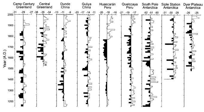
Figure 5-27
Decadal averages of the oxygen isotope records are shown for a north-south transect from Camp Century, Greenland,
to the South Pole, Antarctica. The shaded areas represent more negative, or cooler, periods (as deduced from d18O
isotopic evidence) and the unshaded areas represent more positive, or warmer, periods relative to the respective
means of the individual records. (After Thompson et al., 1993b; reprinted with permission of Elsevier Science.)
appear to be regional in extent, while others are clearly global or near-global (see, e.g., Bender et al., 1994; Stager and Mayewski, 1997).
Additional evidence of variability has been obtained from boreholes in permafrost terrain, and to a lesser extent (because of the shortness of the record) from modem sea-ice and snow-field observations. Oxygen-isotope records from deep-sea sediment cores also indicate long-term variability in the global volume of landlocked ice (Shackleton and Opdyke, 1973), though most of these records are not of a high enough resolution to address dec-cen-scale variability. A similar statement can be made regarding the geomorphological evidence of glacial changes.
Cryospheric evidence of dec-cen-scale climate variability is presented below by region.
Polar Evidence
The waxing and waning of major continental ice sheets during glacial and interglacial stages are recorded in ice cores from both polar regions, as well as those from China, Peru, and Bolivia. However, climate variations during the Holocene apparently were not globally synchronous; they may appear prominently in some records but be wholly absent from others. For example, a period of cooler conditions, correlative with the so-called Little Ice Age from about AD 1500 to 1880, is prominent in cores from a number of sites in East Antarctica. (The ratio of oxygen isotopes, d18O, can serve as an atmospheric-temperature proxy (Yao et al., 1996)). An oscillatory temperature relationship observed over the long term between the ice-core records of East and West Antarctica is also present in the temperature records of this century (Mosley-Thompson et al., 1991). The ice-core d18O histories from the Antarctic Peninsula, however, reveal a strong, persistent warming trend since the 1930s that is absent in East Antarctica. Ice-core records from the Greenland ice sheet also do not reveal a marked warming in this century. In fact, with the exception of the Antarctic Peninsula, there is little evidence for recent warming in the polar regions. The rates of snow accumulation on the polar ice caps show variability over decades.
The sea-ice record, which is available from satellite ob-
Page 99
servations, is approximately 25 years old. In the Southern Hemisphere, it shows some interdecadal variability, for which a physical explanation is currently lacking. The Antarctic sea-ice fields also show evidence of abrupt change during a several-year period in the 1970s—the appearance of the large Weddell polynya, or open-water space that has not been observed since. The extent of Antarctic sea ice does not show any significant trend over this period (Johannessen et al., 1995). However, Bjorgo et al. (1997) explain that Arctic ice extent appears to have decreased over the last 20 years or so, even when the calibration mismatch associated with the change in microwave sensors in 1987 (from the SMMR to the SSM/I) is taken into account. On longer time scales, more discernible trends and variations in the sea ice appear in historical records and in the extensive logs from fishery, whaling, and sealing fleets. For example, using whaling records, de la Mare (1997) found that the Antarctic sea-ice fields retreated a dramatic 2.8 degrees of latitude between the mid-1950s and early 1970s. Zakharov (1997) and Ogilvie (1984) note striking examples of decadal-scale variations of sea ice in the North Atlantic during the past hundred years, and century-scale sea-ice variations near Iceland. Several studies have found decadal-scale relationships between Arctic sea ice and atmospheric anomalies (e.g., Dickson et al., 1988; Deser and Blackman, 1993; and Slonosky et al., 1997).
When so-called inverse modeling methods are used, analyses of precisely measured temperature profiles in permafrost boreholes allow reconstructions of past changes in temperature at the permafrost surface, and also of changes in the surface heat balance. Borehole temperatures thus serve as proxies for mean annual air temperatures. Borehole data indicate that temperatures at the permafrost surface in polar and subpolar regions have indeed undergone cyclic changes of as much as 4ºC over the last decade or so (Lachenbruch and Marshall, 1986; Osterkamp et al., 1994).
Overpeck et al. (1997) found that over the last 400 years, most of the peaks in atmospheric volcanic-sulfate loading, as reconstructed from Greenland ice cores, correlate with episodes of mean circum-Arctic cooling. For example, the coolest phase of the Arctic Little Ice Age appears to have been precipitated by a period of large and frequent sulfur-producing volcanic eruptions in the early nineteenth century. These correlations suggest that a positive feedback may exist between atmospheric sulfate loading and Arctic temperature (Zielinski et al., 1994; Overpeck et al., 1997).
Subtropical and Mid-Latitude Evidence
In contrast to the abundance of records from the polar regions, ice-core histories from the mid-latitudes to the tropics are more limited. Recently, ice coring and glaciological investigations have been conducted on the Tibetan Plateau and in Kirghizia. These data, along with meteorological observations, strongly and consistently indicate a twentieth-century warming (Thompson et al., 1993b).
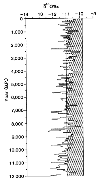
Figure 5-28
Fifty-year averages of oxygen isotopes for the last 12,000 years from Cores 1
and 3 on the Dunde Ice Cap, China. The line at -11 represents the long-term
average of the records; shaded projections indicate warmer-than-average
periods. Note that the most recent 50-year period (1937-1987) is the warmest
since the end of the last glacial stage. (After Thompson et al., 1993b;
reprinted with permission of Elsevier Science.)
In 1987 two cores were recovered from the Dunde Ice Cap (38ºN, 96ºE, 5325 m above sea level (masl)) in the Qilian Mountains on the northeastern margin of the Qinghai-Tibetan Plateau (Thompson et al., 1989). These cores' history, presented in Figure 5-28, show that the latest 50 years of the record were the warmest in the last 12 centuries for the northeastern area of the Tibetan Plateau. On a longer time
Page 100
scale, an ice-core record from the Guliya Ice Cap (also on the Qinghai-Tibetan Plateau) provides evidence of regional climatic conditions over the last glacial cycle.36Cl data suggest that the deepest 20 m of this 308.6 m core may be more than 500,000 years old. The d18O change for the most recent deglaciation is ~5.4 per mil, similar to changes shown in cores from Huascarán (Peru) and the poles (Thompson et al., 1997). The oxygen isotopes vary in a pattern similar to that of the CH4 records from the polar ice cores indicating that the global CH4 levels and the tropical hydrologic cycle are linked.
In 1990 a joint U.S.-U.S.S.R. team visited the Gregoriev Ice Cap (42ºN, 78ºE, 4660 masl) in the Tian Shan region of Kirghizia. They obtained two 20 m cores containing records of climatic variation extending back to 1940 (Thompson et al., 1993b). The d18O profiles in both cores indicate a warming trend since the mid- 1970s. The team also measured borehole temperatures. They found a temperature of -2.0ºC in a borehole 20 m deep at 4660 masl, whereas a 1962 Soviet expedition measured a temperature of -4.2ºC at 20 m even though their borehole location was at only 4400 masl. This indicates a warming of several degrees in the near-surface mean annual air temperatures since the early 1960s. (Because some refreezing of meltwater occurs on Gregoriev, this 2.2ºC difference is considered an upper limit.)
There appears to be evidence of significant variability in the distribution of the snow fields in Canada between 1915 and 1992 (Brown and Goodison, 1996). Remotely sensed data from the Advanced Very High Resolution Radiometer (AVHRR) also show decadal-scale changes in the areal extent of snow cover over both Eurasia and North America (Robinson et al., 1993; Walland and Simmonds, 1997). The AVHRR-based data, which begin in the early 1970s, indicate more extensive snow cover in the 1970s to mid-1980s relative to the later part of the time series; the decline occurs over a span of approximately five years, from 1985-1986 to 1989-1990. Walland and Simmonds (1997) found significant co-variability between Eurasia and North America, with the Eurasian signal lagging behind the North American signal by over a year. The approximate 10 percent reduction in Northern Hemisphere snow cover that occurred in the latter part of the 1980s has likely increased the radiative balance and surface temperature (up to 1.5ºC) over the northern extratropical land area, particularly in the spring (Groisman et al., 1994a,b). The Eurasian winter snow fields also appear to co-vary with sea-ice distribution north of Siberia (Maslanik et al., 1996).
Tropical Evidence
There is mounting evidence for a recent, strong warming in the tropics, which is signaled by the rapid retreat and even disappearance of ice caps and glaciers at high elevations. These ice masses are particularly sensitive to small changes in ambient temperatures, since they already exist very close to the melting point. One of the best-studied tropical ice caps is Quelccaya (13ºS, 70ºW, 5670 masl) in southern Peru. In 1983 two ice cores that went down to bedrock were recovered from there, providing the first conclusive tropical evidence of the Little Ice Age (Thompson et al., 1986). Since 1976 Quelccaya has been visited repeatedly for extensive monitoring. In 1991 and again in 1995 shallow cores were drilled at the summit, near the sites of the 1983 deep drilling and a 15 m coring in 1976. Comparison of the d18O records from these four cores (1976, 1983, 1991, and 1995) reveals that the seasonally resolved paleoclimatic record, formerly preserved as d18O variations, is no longer being retained within the currently accumulating snowfall on the ice cap. The percolation of meltwater throughout the accumulating snowpack is vertically homogenizing the d18O.
The extent and volume of Quelccaya' s largest outlet glacier, Qori Kalis, was measured six times between 1963 and 1995. These observations documented a drastic retreat that has accelerated over time. Brecher and Thompson (1993) reported that the rate of retreat from 1983 to 1991 was three times that from 1963 to 1983, and in the most recent period (1993 to 1995) the retreat was five times faster. Associated with this retreat was a sevenfold increase in the rate of volume loss, determined by comparing the 1963-to-1978 volume-loss rate to that of 1993 to 1995. Observations made in 1995 confirmed Qori Kalis' accelerating retreat (see the upper portion of Color plate 4), as well as further retreat of the margins of the Quelccaya ice cap, and the development of three adjacent lakes since 1983.
In 1993 two cores were drilled from the col of Huascarán (9ºS, 77ºW, 6048 masl), a mountain in the north-central Andes of Peru (Thompson et al., 1995). The d18O data from these cores (see the lower portion of Color plate 4) indicate that the nineteenth and twentieth centuries were the warmest in the last 5,000 years. Their d18O record and meteorological observations made in the region reveal an accelerated rate of warming since 1970, concurrent with the rapid retreat of ice masses throughout the Cordillera Blanca and of the Qori Kalis glacier.
Additional evidence exists for recent warming in the tropics. Hastenrath and Kruss (1992) reported that the total ice cover on Mount Kenya has decreased by 40 percent between 1963 and 1987. Kaser and Noggler (1991) reported that the Speke Glacier in the Ruwenzori Range of Uganda has retreated substantially since it was first observed in 1958. The shrinking of these ice masses in the high mountains of Africa is consistent with similar observations at high elevations along the South American Andes, and indeed throughout most of the world (see Figure 5-29). This general retreat of tropical glaciers is concurrent with an increase in the water-vapor content of the tropical middle troposphere, which may have led to warming in the tropical troposphere (Flohn and Kapala, 1989; Diaz and Graham, 1996).
Page 101
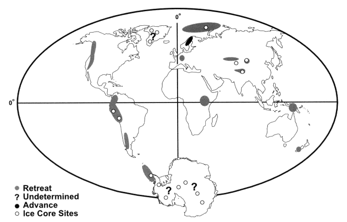
Figure 5-29
Changes in global ice cover during the twentieth century. (Figure courtesy of Lonnie G. Thompson, Byrd Polar Research Center.)
Mechanisms
The cryosphere is thought to be one of the most sensitive components of the climate system. Its variability is driven by external forcing, as well as by internal and coupled modes. Its response to external forcing is most dramatically demonstrated by the waxing and waning of the glacial ice sheets, which is paced by changes in solar irradiation. These irradiance changes, which are caused by changes in the Earth's orbital parameters (see, e.g., Hays et al., 1976), are small in magnitude, but significant in their seasonal distribution, specifically in the high Northern Hemisphere latitudes. These changes in total solar irradiance appear to be responsible for the largest variations in climate experienced over the last several million years: the ice-age cycles. While the details by which this small change in forcing is amplified are still unknown, Imbrie et al. (1992) suggest that the Arctic sea-ice fields respond directly to the radiative changes. The resulting change in freshwater exported to the thermohaline source regions of the North Atlantic influences the effectiveness of the thermohaline circulation system, thereby communicating the regional changes elsewhere in the globe. (For instance, large changes may be induced in the Antarctic sea-ice fields). While this particular scenario is controversial, the fact that the extent of the continental ice sheets shows strong correlation with the level of external radiative forcing (see, e.g., Imbrie et al., 1984) suggests a high sensitivity to that external forcing.
Volcanic activity can also have a strong influence on the cryosphere (Overpeck et al., 1997). Volcanic-ash deposition can change ice and snow cover from being one of the most highly reflective media in the climate system (and thus greatly resistant to direct solar radiative melting) to one of the most absorptive (and thus highly susceptible to radiative melting at the surface). This change in albedo can have a large influence on climate when ash is deposited on the relatively thin sea-ice cover; when the ice is melted, the low-albedo ocean surface is exposed, and further surface warming will result. Sea-ice cover greatly reduces the ocean-atmosphere exchange of heat, moisture, and radiatively active gases, so its removal would alter all of those properties. The reduction in the heat flux associated
Page 102
with sea-ice removal is typically between a factor of 20 (thin Antarctic ice) and 100 (thick Arctic ice), levels that can significantly influence regional warming and gas exchange.
Finally, the cryosphere's sensitivity to anthropogenic forcing is not yet known. GCM simulations often show a high sensitivity to changes in sea-ice fields in global-warming simulations. For example, recent numerical simulations of global climate, under conditions of doubled atmospheric CO2, show that an impressive 38 percent of the annual average global warming could be attributed to the response of sea ice (Rind et al., 1995). Note, however, that while sea-ice changes seem to constitute a considerable positive feedback in the warming, it is highly uncertain what the response of the sea ice to global warming will actually be. This uncertainty is most clearly revealed by similar model experiments regarding the response of the Southern Ocean sea-ice fields to a doubling of atmospheric CO2: smaller sea-ice changes occur in simulations using the coupled atmosphere-ocean GCM of Manabe and Stouffer (1994) than in the coupled model of Washington and Meehl (1995). Currently, the details of the anthropogenic forcing mechanism and its net influence are still very much in question.
Clearly the most important mechanisms influencing cryospheric variability are its couplings to the atmosphere, ocean, and land surface. They lead to a set of geographically unique polar feedbacks such as the ice/snow-albedo feedback, ice-cloud feedback, ice-ocean feedback (the effects of which apply to a variety of scales, from those influencing the sea-ice distribution to those influencing the vigor of the global thermohaline circulation), and ice-sheet-ocean feedback, including associated instabilities. Each of these feedbacks is discussed below.
The ice-albedo feedback encompasses an entire suite of processes that influence the concentration, spatio-temporal distribution, and surface characteristics of ice. All these characteristics influence surface albedo, which in turn alters the surface radiation balance, which feeds back onto the process itself. For example, sea-ice concentration—which reflects a balance between the advective divergence/convergence of ice and the thermodynamic decay/growth of ice (both processes open/close leads, areas of open water)—influences air-sea heat flux and albedo. In turn, both the air-sea heat flux and albedo influence the thermodynamic growth/decay rate, thereby further altering the ice concentration.
The surface characteristics of ice and snow, which can change albedos from a high of near 0.6 to a low of 0.3, are influenced by moisture content, seawater flooding, ice ridging, age, thickness, and crystalline properties. These are a function of dynamic conditions forced by the winds and ocean currents, ice thickness controlled by the atmosphere and ocean heat fluxes, atmospheric temperatures, snow loads, atmospheric surface history, and more. Many of these processes and characteristics are themselves a function of the albedo.
A comparable set of feedbacks involving land, snow, and atmosphere can influence the distribution of vast snowfields on high-latitude land masses. Because of snowfields' high albedo and great areal extent, even small changes in their distribution can have a considerable influence on regional and hemispheric conditions. The snow insulates the ground, controlling its temperature profile and heat content. These in turn influence the productivity of the local ecosystems, as well as the snow thickness and albedo, by moderating the snow's basal heat flux. The interaction between permafrost, vegetation, and the storage and release of methane also can lead to climatic feedbacks on longer time scales.
Snow-cover variations on the high Tibetan Plateau may be important because of the effect of surface albedo on the strength of the Asian monsoon (Sirocko et al., 1993). The intensities of E1 Niño events may also be influenced by plateau snow cover. On longer time scales, model simulations indicate that increases in snow and ice cover during the last glacial maximum on the Tibetan Plateau, along with the resulting increases in albedo, may have caused weakening of the monsoonal circulation (Kutzbach et al., 1998).
In addition to the surface albedo of ice and snow, the surface and basal boundary conditions and internal thermodynamics of ice and snow control the surface temperature, which in turn controls the surface longwave back-radiation, and thus atmospheric conditions. The details of this coupled mechanism and the sensitivity of climate to it are not yet known, though model experiments suggest that subtle errors in surface temperature can introduce a systematic bias leading to unrestrained temperature growth in the models.
The ice-cloud feedback includes a variety of processes that determine the local cloud formation and distribution, primarily as a function of the atmospheric column structure, moisture content, and radiative balance. These processes and properties are intimately tied to the surface conditions. For example, increased ice concentration reduces the area of exposed ocean surface, decreasing the surface heat and moisture sources. Surface heat plays a fundamental role in determining planetary boundary-layer characteristics, and surface moisture determines the local availability of water for cloud formation. Visual images of the Antarctic obtained from satellites show that large areas of open ocean (associated with polynyas) in the frigid ice fields lead to considerable convection and local cumulus generation, which are more typical of tropical regions. Even the presence of surface-melt ponds throughout the Arctic pack-ice fields in summer leads to extensive ground fogs, which have considerable influence on the surface heat balance. Limited studies in the polar regions suggest that many of the surface-cloud feedbacks that are observed in lower-latitude regions behave differently in ice-covered regions (Curry et al., 1996).
The ice-ocean feedback influences the formation and ventilation of global deep and bottom waters, while significantly constraining the ice's thickness and spatial/temporal distribution. This feedback reflects the important role that
Page 103
salinity plays in determining the density of water in cold regions, although it is moderated to some extent by the associated latent-heat effects. Sea ice is the predominant source of mobile freshwater, while the growth of sea ice drives surface salinity fluxes. As sea ice grows, it rejects seawater salt, which works its way back into the surface ocean as a brine solution flowing through drain channels (whose density and effectiveness may be a function of temperature). Ice growth thus serves as the chief source of surface salt, which is the dominant determinant of the surface buoyancy flux in winter. Salt rejection is one of the mechanisms that effect the density changes that lead to ocean convection, both shallow and deep. Convection ventilates the ocean and controls the formation of the intermediate, deep, and bottom waters that drive the global thermohaline circulation. Even shallow convection can mix a considerable amount of heat into the surface of the ocean, and heat content strongly influences ice thickness and concentration and moderates the extent and seasonality of lead formation.
The huge margins of the ice sheets, which float on the sea, contribute considerable freshwater to the ocean, through both basal melting and ''calving" of icebergs. When this meltwater is injected at depths significantly below sea level (i.e., from the bottom of a marginal ice shelf) in the Antarctic, the high compressibility of the cold water leads to the formation of dense plumes of deep water. When the meltwater is injected at the surface, from icebergs, the freshwater can stabilize the surface water and inhibit deep-water formation. The rates at which all these processes occur will change with ocean temperature, which can reflect local, regional, or global influences.
Both sea ice and its snow cover, which represent the predominant source of freshwater in the polar regions, stabilize the locations of polar ocean convection. Ice growth in one location—along a continental shelf, say—will tend to enhance convection there through salinity rejection. As that ice drifts offshore due to local winds and later melts, the salinity decrease will tend to suppress convection. In either case, convection and melt zones are stabilized by this freshwater input. If the freshwater budget is altered through variations in ice flux, then the vertical stability of the ocean may change, leading to a reduction or enhancement of deep-water formation and ventilation. The significance of this surface freshwater flux is determined by the underlying ocean structure, which is governed by the regional wind-stress forcing and local stratification.
The ice-sheet-ocean feedback is a function of the sensitivity of the huge ice sheets (formidable reservoirs of freshwater), of sea level, and of ocean temperatures. The rate at which an ice sheet flows into the sea is controlled in part by internal pressure gradients reflecting the thickness and height of ice near its center of accumulation relative to that at the margins, and in part by the effectiveness of the frictional coupling at its lower boundary. As glacial ice flows out onto the ocean, the friction is removed, and the ice floats and thins as it spreads away from the continental "grounding line." If sea level is raised, this grounding line may be shifted inland, causing the ice to decouple from the bedrock and move more rapidly out into the ocean. The rate of this acceleration will depend on the nature of the coupling with the bedrock: If the ice is frozen to the Earth, the friction is considerable, and its elimination will have a large relative effect; if the coupling was moderate to begin with due to an unconsolidated Earth base, or due to basal melting from the pressure, the elimination of the friction leads to a smaller relative effect. The slope of the continental landmass inland will also determine the effect of a sea-level rise. A shallow slope can lead to a dramatic shift in grounding line, but the shallow slope will lead to a weaker driving pressure gradient. A steep topography may result in a minimal shift of grounding line, but the considerable pressure gradient may result in great destabilization and rapid drainage of the ice sheet. In either case, the change in sea level can influence the rate of ice drainage and thus the rate of additional sea-level change.
Internal mechanisms of cryospheric variability are usually significant only for the large ice sheets. Internal ice dynamics may be responsible for altering the basal friction coupling and internal flow dynamics of large ice sheets; however, the details of these processes are not well known. Dynamic instabilities can influence the rate at which ice sheets drain into the ocean, and thus the rates of both sea-level rise and freshwater supply to the surface oceans. Ice-sheet surges induced by these instabilities may account for the vast armadas of icebergs that roamed the North Atlantic during the last glacial period, leading to the episodic, brief Heinrich events in that region (MacAyeal, 1994). Some suggest that the influence of Heinrich events reaches well beyond the North Atlantic (see, e.g., Bond and Lotti, 1995). It has been speculated that the West Antarctic ice sheet has collapsed in the past, possibly because of the aforementioned instabilities; if such a collapse were to happen again, its impact on global sea level over centennial time scales would be tremendous.
Yet another set of polar feedbacks is associated with sea-ice rheology. Internal ice deformation and flow influence lead formation (affecting ice concentration), ridging events (affecting ice-surface conditions, seawater flooding, and ice thickness and concentration), and ice-flow directions (affecting freshwater distribution and ice concentration). Each of these will influence the albedo, ice-cloud feedback, and ice-ocean feedback. The relative importance of these internal feedbacks for cryospheric variability is not fully known at this time.
Remaining Issues and Questions
• How have the sea-ice, snow, and permafrost fields changed on dec-cen time scales, and what is the relationship of these changes to dec-cen patterns of atmosphere, ocean,
Page 104
and land-surface variability? As discussed earlier, the NAO and PNA extend into the Arctic, and their indices often reflect changes originating in the polar low-pressure cells. It is therefore important to determine the degree of co-variability between changes in ice and snow fields and patterns such as these. Sea-ice changes have been implicated in changes in the thermohaline circulation on a variety of time scales; how do they co-vary? What spatial and temporal patterns of contemporary polar climate change are manifested in changes in permafrost temperature profiles?
• Through what mechanisms do sea-ice fields, atmosphere, and ocean interact on dec-cen time scales? Do regional or even local changes in ice divergence alter the albedo, surface heat and moisture fluxes, upper-ocean conditions, and cloud formation enough to influence the Icelandic or Aleutian lows, and thus the NAO and PNA? How do similar near-surface changes influence atmospheric circulation in the Southern Hemisphere? Do changes in such patterns, in large-scale planetary waves, or in ocean circulation alter polar conditions enough to drive other polar changes that may result in changes to other parts of the climate system? For example, would a change in NAO influence the volume of freshwater exported from the Arctic in the form of sea ice enough to significantly alter the thermohaline circulation? Observational evidence says it might (Dickson et al., 1997), as do model experiments (Tremblay, 1997). Also, the thermohaline circulation is sensitive to surface buoyancy fluxes in source regions. These sources lie predominantly in the polar regions, where the growth, decay, and spatial redistribution of ice play dominant roles in the buoyancy flux, and thus may exert a strong influence on the process of mid- and deep-water formation. The ice in turn is highly dependent on the stability of the underlying water column, setting the stage for considerable feedbacks and interactions among the system components.
• What are the mechanisms of interaction among the snow fields, permafrost, atmosphere, and land systems on dec-cen time scales? Do snow-related changes in surface albedo, surface heat and moisture fluxes, soil moisture, vegetation cover, and cloud formation significantly influence atmospheric patterns or large-scale planetary waves, and thus drive long-term feedbacks in the climate system? For example, do changes in the seasonal or spatial distribution of extensive winter snowfields alter the surface vegetation or soil moisture enough to drive longer-term influences elsewhere in the climate system? What are the physical relationships between permafrost surface temperature, surface air temperature, and other climatic parameters, and what are the mechanisms controlling these relationships?
• What are the mechanisms by which changes in the cryosphere of the polar regions are linked or teleconnected to mid-latitude and tropical regions? Model results suggest that changes in the sea-ice fields alter the nature of the Hadley cell through their influence on the equator-to-pole meridional temperature gradient. Observations suggest that the Antarctic Circumpolar Wave co-varies with ENSO and Indian Ocean monsoons through mechanisms not yet understood. Changes in the thermohaline circulation may be related to changes in the surface freshwater balance associated with the growth and transport of sea ice. The ocean's interaction with ice shelves can alter the surface volume (and thus the gyre characteristics) in the subtropical regions, which alter SST without any change in surface forcing.
• What are the historical and current global budgets of glacial ice and snow, and what are the primary mechanisms controlling those budgets? Because glacial ice and snow budgets directly affect sea level, we need to better quantify the mass balance of the continental ice sheets, alpine glaciers, and permanent snow fields. In particular, the ice mass balance at the base of the floating ice shelves is in considerable question, and whether the Greenland and Antarctic ice sheets are gaining or losing mass is still uncertain. Establishing how this ice and snow budget has varied through time will give some indication of the range, rate, and rapidity of change experienced through natural variability. The IPCC (1996a) lists four major gaps that need to be filled to obtain better estimates of glacier contribution to sea-level rise:
1) development of models that link meteorology to glacier mass balance and dynamic response;
2) extension of models to those glaciers expected to have the largest influence on sea level (the valley and piedmont glaciers of Alaska, Patagonian ice caps, and monsoon-fed Asian glaciers);
3) quantification of the refreezing of meltwater inside glaciers; and
4) better understanding of iceberg calving and its interaction with glacier flow dynamics.
Other areas of uncertainty concerning ice budgets are the controls on the melt/growth rate at the base of floating ice sheets, including the rate of ice-sheet drainage as a function of sea level (which alters friction), as well as the precipitation response to cold-region climatic changes.
Processes and Parameterizotions
The internal dynamics and thermodynamics of sea ice and ice sheets are generally fairly well understood, and can be readily parameterized despite their complexity. The largest uncertainties in predicting the extent and thickness of sea ice and glacial ice lie in the treatment of the boundaries. For example, the surface albedos of ice and snow under a variety of conditions, and how those conditions arise, are still poorly resolved and understood. Heat fluxes across the boundaries can be reasonably parameterized, but for sea ice, the partitioning of lateral versus vertical heat fluxes at the edge and base of sea ice with the ocean is still not understood. This
Page 105
particular distribution dictates the partitioning between lateral growth/decay of the ice (controlling its geographic distribution) and vertical growth/decay (controlling its thickness). This partitioning in turn controls the lead area and thus the extent of the ice cover, which then affects the albedo, ice-cloud feedback, and the effectiveness of the insulating ice cover and air-sea heat flux. Even if this partitioning were understood, ice modeling would remain problematic because the prediction of lateral wall area for a given concentration of ice, or surface forcing, is conceptually difficult.
Considerable uncertainties are associated with the prognostic treatment of polar clouds. Prognosis is further complicated by the possibility that polar clouds respond differently from clouds in other regions to changes in surface and forcing conditions. Better-polar cloud modeling is needed to more realistically depict the important ice-cloud feedback discussed above, and an extensive, fundamental observational data base is required as well. The observations will improve our theoretical understanding of polar processes as well as our ability to predict polar-cloud behavior.
Other aspects of the surface energy balance need to be better understood to improve long-term cryosphere and climate predictions. These include the details controlling the spatial heterogeneity of ice surface conditions and their net influence on surface fluxes, and the extent to which seawater flooding of thin, seasonal ice cover affects their melting and albedo, particularly in the Antarctic polar oceans. Seawater flooding not only may alter the thermodynamics of the system, but may be corrupting interpretations of satellite images of ice concentration, confounding our ability to monitor the ice and evaluate the models.
Models have treated the basal boundary condition of ice sheets as a function of underlying surface composition and temperature, as well as of the ocean-ice-sheet interaction along ice shelves. The observations needed to test these formulations are lacking, however. Correct model treatment of ice streams, which are small-scale features with high flow rates, will also require further study. These streams represent a major path through which ice sheets are drained, and their distribution may greatly alter estimates of average ice drainage and ice-sheet stability.
Some of the larger-scale polar feedbacks—for instance, the export of ice from the Arctic, its role in the formation of North Atlantic Deep Water, and long-time-scale feedbacks into the polar regions from any such process—are still a long way from being fully understood. Likewise, neither the long-term feedbacks between the climate system and the polar regions, nor the various local and regional feedbacks already discussed, are well understood—in particular, how the small-scale feedbacks affect the larger-scale climate processes. Finally, the prognostic treatment of snow, like that of precipitation in general, is still a difficult prospect. Some progress has recently been made, however, although considerable effort will be required to obtain even a statistically correct representation of the spatial and temporal distribution of the snow fields and their dependencies.
Observations
Several types of observations are critical to the issues articulated above. Long-term monitoring of sea-surface salinity along with SST is important, since salinity represents the dominant control over the water density of high-latitude regions. The sea-ice distribution, motion fields, and thickness need to be known in order to determine the associated freshwater transports and buoyancy fluxes. Permafrost temperature profiles provide unique indications of integrated dec-cen climate change over vast geographic regions; more such profiles should be collected in order to better define the spatial and temporal distribution of change. Consistent monitoring of iceberg calving and an observational system for determining the basal melt or growth of sea ice (e.g., an array of moored buoys measuring temperature and salinity across the floating ice shelves) must be established before the sea-ice budget can be closed. Finally, both field and satellite studies are needed to refine the mass budgets of the Greenland and Antarctic ice sheets. On-site studies focused on changes in ice flow, melting, and calving should be continued and extended. Observations of water-vapor net flux (divergence) will help to pin down the source of the ice sheets' mass. A laser altimeter on a polar-orbiting satellite is needed to augment the existing radar altimetry. These instruments will provide accurate estimates of ice-sheet volume and give early warning of possible ice-sheet collapse.
Model parameterizations must be improved to better represent the ice-albedo feedback, snow-climate feedbacks, ice-cloud feedback, ice-ocean feedback, ice-sheet-ocean feedback, and ice-sheet instabilities. Also, simulation of sea-ice and snow distribution and related impacts must be improved. Randall et al. (1998) have described some of the observational requirements necessary to improve our ability to model these processes on large scales, and some of the existing research programs that have been designed to fulfill these requirements.
The feedbacks among the hydrologic cycle (including river runoff into the Arctic), the atmospheric circulation, and the thermohaline circulation must be better understood on a variety of scales, because such larger-scale feedbacks may play a fundamental role in polar climate. The potential for extracting high-resolution records of past climate change from polar sediments along the Antarctic continental shelves and slopes and in polar fjords and Arctic lakes and estuaries (the latter being the primary focus of the Paleoclimates of Arctic Lakes and Estuaries (PALE) program of the Arctic System Science initiative) should be evaluated, and pursued if proven feasible.
Page 106
Land and Vegetation
Influence on Attributes
The state of the land and its vegetation affect the climate in a number of ways. The fraction of solar irradiance absorbed by different landscapes depends on vegetation. For example, deserts reflect a greater portion of the incoming solar radiation than vegetated regions do. Of the vegetated regions, grasslands reflect more radiation than surfaces covered by forests. The influence of vegetation on albedo is amplified when the angle of incident solar radiation is low, as it is during high-latitude winters, and when snow covers the ground; forests present a light-absorbing layer above the snow, whereas bare ground and grasses do not. To assess the sensitivity of high latitude regions to the albedo effect of boreal vegetation, Bonan et al. (1992) computed the climate response of a GCM in which the forests north of 45ºN were replaced by bare ground. The zonally-averaged temperatures in this deforestation simulation were generally between 3 and 10ºC colder in the mid- to high-latitudes, relative to a simulation conducted with the same GCM in which forests north of 45ºN were present. Whitlock and Bartlein (1997) suggest that changes in vegetation may have played a significant role in climate changes in northwest America over the last 125,000 years. In a set of GCM simulations of Cretaceous-era climate, Otto-Bliesner and Upchurch (1997) found that the globally averaged temperature was over 2ºC warmer in a model run that included a best-guess estimate of global vegetation cover than in one in which bare soil covered the land surface. The vegetation decreased the surface albedo, causing high-latitude areas to warm and delaying sea-ice formation, which in turn further decreased albedo and increased temperatures.
Processes in the soil and plants both absorb and produce long-lived greenhouse gases (CO2, CH4, N2O), thereby influencing the atmosphere's infrared-radiation budget. Vegetation emits chemically reactive organic gases (terpenes, isoprene, methanol, etc.) that are involved in atmospheric reactions that lead to production of ozone in the troposphere. Photochemical processes in the lower atmosphere also cause small particles to be created from hydrocarbons emitted by plants. These particles scatter light, causing a visible bluish haze that decreases the transmission of solar radiation to the ground. Soil and mineral dust, whose atmospheric entrainment is influenced by vegetation cover, also affects the scattering of light. Both surface temperature and turbulent mixing of air in the planetary boundary layer are functions of wind friction at the Earth's surface. Surface roughness is greatly influenced by both the stature and density of vegetation, in addition to the effects of topography.
Plants also partly control the hydrologic cycle through evapotranspiration, as noted earlier in this chapter. Leaves open their stomata during photosynthesis, causing them to lose water vapor into the atmosphere while taking up CO2. Roughly two-thirds of precipitation over land is recycled water vapor from plants. Model simulations of the Amazon confirm that the vegetation plays an active role in maintaining the regional hydrologic regime; simulated deforestation resulted in dramatically decreased precipitation and increased temperature and evaporation (Shukla et al., 1990). Soils, which are a very slowly created mixture of rock-weathering products and organic material derived from plants, function as a reservoir of water. They thus influence the timing of evaporation from the land surface. Therefore, plants indirectly influence surface temperature through their effect on soil moisture, which has a large heat capacity, and thus influences latent heating. Evapotranspiration also changes the balance between the fluxes of sensible and latent heat at the surface, causing local surface cooling. When plants are water-stressed, their stomata may close to reduce transpiration and conserve water, thereby warming the surrounding air. The expected physiological response of plants to a high-CO2 world would be to close their stomata somewhat, reducing their evaporative loss, but furthering warming over the continents (Sellers et al., 1996).
The urban landscape has a marked influence on climate; a recognized problem in studies of long-term temperature change is that many meteorological measurement sites have gradually become absorbed into expanding metropolitan areas, known as ''urban heat islands." The artificial heat output of the greater New York metropolitan area is about one-eighth of the solar energy absorbed there on the ground. Furthermore, wind speed has diminished, particle loadings have increased, anthropogenic emissions of many trace gases have increased, and precipitation and other weather features have changed markedly for tens of miles downwind from many urban areas (Barry and Chorley, 1992).
Evidence of Decade-to-Century-Scale Variability and Change
The major ecosystem zones (biomes) of the Earth, such as tundra, temperate grassland, and wet tropical forest, are determined in part by the range and variability of a region's temperature and precipitation. The type of vegetation prevalent in the past at a given location is sometimes recorded in pollen buried in ancient soils and sediments. Such data show that large vegetation changes have occurred in many areas in response to climate change. For example, pollen data tell us that large parts of the Sahara, although currently completely barren, supported vegetation (savanna woodland and desert grassland) from about 9500 to 4500 BP (see, e.g., Ritchie et al., 1985). Evidence has been found of increased lake levels in the area during the same time period; both conditions have been linked to a strengthened monsoon circulation in that period (Kutzbach and Street-Perrott, 1985). In western Europe, many tree species such as pine, elm, and oak migrated
Page 107
northward and westward with surprising rapidity (typically 150 to 500 m per year) after the close of the last ice age, replacing a shrub-dominated vegetation (Huntley, 1988). Species adapted to Arctic and alpine tundra suffered a crisis in western Europe during the warm period in the mid-Holocene, around 6000 BP, when their habitat was at a minimum. More recently, the succession in which the dominant tree species changed from beech to oak to pine during the Little Ice Age has been recorded in pollen in southern Ontario (Campbell and McAndrews, 1993).
Between one-third and one-half of the Earth' s surface has been transformed by human actions (Vitousek et al., 1997). The evidence of ecosystem variations is especially pronounced during the last 150 years. Vast tracts of temperate forest were cut down during the nineteenth and early twentieth centuries. The location of greatest deforestation has shifted to the tropics in the most recent decades. One-fifth of the tropical forest area was lost between 1960 and 1990, and it is estimated that the remaining area is being lost at a rate of 7 percent per decade (WRI, 1996). Today, almost 40 percent of the Earth's land area (excluding Antarctica) is devoted to cropland and permanent pasture (WRI, 1996). Most of this agricultural expansion has occurred at the expense of forests and grasslands; only a few small patches of original prairie remain on the North American continent. The majority of wetlands in the United States have been drained (Kusler et al., 1994) during the last half-century. Aerial photography shows clearly how dominant society's influence over the land is—human settlements and structures, roads, a checkerboard of croplands, artificial lakes, coastal modifications, and so on. Currently about 8 percent of the land in Western Europe is (sub)urbanized or covered by roads, and 45 percent is devoted to cropland and pasture; in the United States the corresponding figures are 4 percent and 45 percent, respectively (WRI, 1996). It is possible, of course, that the relatively large portion of the land surface that is managed in some way by humans may permit us to exert a modest amount of deliberate climate control, since we can control the reflective and absorptive properties of man-made structures.
Evidence for changes in the amount of carbon stored in vegetation and soils derives principally from our knowledge of changes in land use. Deforestation results in the loss of carbon in standing wood, and causes oxidation of part of the organic carbon stored in forest soils. Agricultural practices and reforestation also affect the carbon balance. Combining the recorded global history of land use with time-dependent models of carbon dynamics, Houghton et al. (1987) estimated the loss of carbon to the atmosphere that can be attributed to direct human intervention to be 1.0-2.6 Gt of carbon per year in 1980; this flux has varied through time since at least 1850 (Houghton, 1993; IPCC, 1996a). While land-use changes are important, recent climate variability has probably also led to substantial changes in vegetation-related carbon fluxes. Using historical temperature and precipitation data in conjunction with a carbon-cycle model, Dai and Fung (1993) found that climate may have caused significant interdecadal variations in regional and global terrestrial carbon storage since 1940. Observations of increasing amplitude of intra-seasonal atmospheric CO2 variations (Keeling et al., 1996a) and remotely-sensed, large-scale increases in terrestrial photosynthetic activity (Myneni et al., 1997) suggest that plant growth has increased in recent years.
Measurements of CO2 concentrations in ice cores provide a very clear record of changes in carbon storage between glacial and interglacial times, but these measurements do not directly distinguish the respective roles played by the oceans and the terrestrial systems in causing the atmospheric concentration changes. Obviously changes in carbon storage can be expected when the geography of vegetation is significantly altered (Prentice and Sykes, 1995; Friedlingstein et al., 1995). It has also been inferred from ice-core records that the emissions of CH4 varied between glacial and interglacial periods (Chappellaz et al., 1993b; Thompson et al., 1993a), and that they have strongly increased in recent years. Changes in ecosystem types and land use (wetlands, rice paddies, cattle grazing, etc.) clearly have had a major impact on these emissions. Global N2O emissions have also increased during recent decades, but there is still considerable uncertainty as to the cause.
Mechanisms
Past vegetation changes have been driven by natural climate variations. Regional and global models of vegetation dynamics are based on the sensitivity of species and ecosystems to variables such as the mean coldest-month temperature, the annual accumulated temperature over 5ºC, precipitation, and soil moisture capacity (see, e.g., Prentice et al., 1992; VEMAP, 1995). These variables reflect vegetation characteristics, such as: most woody tropical plants are killed when the temperature drops below 0ºC, and for a species to sustain growth, the air temperature must exceed a species-specific minimum value for a species-specific minimum length of time (expressed as growing degree days). The climate warming that has been projected for the coming centuries could induce changes to natural vegetation as great as those at the end of the last ice age; species distributions in North America could be shifted by as much as 500 or 1,000 km (Overpeck et al., 1991). The variability and types of disturbance are another significant factor in determining ecosystem composition and distribution. For instance, the frequency and severity of wind storms and fires affect the migration and establishment of species and ecosystems, and need to be taken into account in predicting the geography of future ecosystems (Overpeck et al., 1990).
At present, the dominant reason for changes in vegetation is direct human intervention, both purposeful and inadvertent. More than half of the ice-free surface of the continents has been altered substantially by human uses (Kates et al.,
Page 108
1990). Our need for food and resources drives land-use patterns that result, either rapidly or gradually, in land-cover changes. Vitousek et al. (1986) estimate that 31 percent of all net primary production on land directly serves humans as fiber, food, or fuel; 2.3 percent is actually consumed by us or by animals that we use for food. As human populations grow and place even more demands on our natural environment, this already pervasive influence of humans on the Earth's biota is likely to concomitantly increase. Anthropogenic change in ecosystem functioning can also result from the removal of predators or the introduction of invasive species.
Both direct and indirect effects of CO2 have been recognized as mechanisms of change in the interaction of, and competition between, species composing the vegetation on undisturbed land. Fertilization of plant growth by higher atmospheric CO2, and by moderate amounts of wet and dry deposition of nitric acid, has a demonstrable influence on vegetation. To test the response of intact ecosystems to CO2 changes more realistically than in laboratory settings, so-called free-air CO2 enrichment (FACE) experiments are being carded out, in which CO2 is pumped over ecosystems in their natural environment. One such experiment, carded out in Chesapeake Bay wetlands, is reported by Drake (1992). Long-term CO2-enrichment studies with manipulated microclimate have also been carried out in enclosures, an example of which is the assessment by Tissue and Oechel (1987) of the effects of temperature and CO2 change on Arctic tundra. The responses to elevated CO2 in the Arctic and Chesapeake Bay cases were quite different, which suggests that nutrient (especially nitrogen) availability may play an important role in regulating response to increased CO2 and temperature (Rastetter et al., 1992). Another effect of enhanced levels of CO2 is that plant root-to-shoot ratio tends to increase (Rogers et al., 1994). Schindler and Bailey (1993) estimated that the amount of carbon storage stimulated by anthropogenic nitrogen deposition may be between 1.0 and 2.3 Gt of carbon per year. Others, such as Asner et al. (1997), consider the potential of this effect to be lower.
Not only does enhanced CO2 fertilization tend to increase the amount of carbon stored in live vegetation, but it can alter the species balance of ecosystems. For instance, under greater ambient CO2 concentrations, C3 plants (the majority of crops) tend to be favored over C4 plants (some essential warm-weather crops, including corn and sugar cane) (Poorter, 1993). Shifts in species composition may also arise from changes in the availability of nutrients (Wedin and Tilman, 1996). By affecting climate, elevated CO2 levels may also indirectly influence the number and balance of species in ecosystems (Davis and Zabinski, 1992; Barry et al., 1995).
There is increasing awareness that future ecosystems may not represent a simple, climatically driven redistribution of ecosystems as they are currently composed. Rather, mechanisms such as those mentioned above must be taken into account in predictions about future ecosystems. Furthermore, factors such as changes in land use and management, which are quite difficult to predict, are likely to be at least as important as climate-related changes. Direct human intervention and climate change do not act as independent agents of vegetation change. Both the U.S. Dust Bowl of the 1930s and the desertification in the Sahel are examples of how unfavorable climatic conditions and societal demands may synergistically lead to environmental degradation.
Variations in fire frequency and intensity can often be related to variations in climatic conditions. For instance, the widespread fires in southeast Asia in 1997 have been attributed to the extreme E1 Niño-related drought at that time. In addition to having a direct economic impact when fires affect forestry and personal property, such changes can also influence ecosystems in a number of ways. Active suppression of forest fires, while benefiting humans in many ways, can be detrimental to certain species that depend on fire for various reasons (e.g., facilitating germination). Moreover, fire suppression can lead to age homogenization, in which forests tend to become dominated by single-age stands. Although uniform forests are often high in timber productivity, the decrease in diversity leaves them generally more vulnerable to fire, windstorms, disease, and other naturally occurring events (Noss and Cooperrider, 1994). Increased fire frequency can also cause local extinctions of species, even in mature forest stands (Gill, 1994).
Acid deposition has led to widespread dieback of trees, especially at higher elevations. Elevated surface ozone can reduce photosynthesis, increase respiration, and lead to leaf senescence earlier in the season (Chameides et al., 1994), all of which reduce productivity. Increased UV-B radiation has been shown to reduce photosynthesis and growth in many species in greenhouses, although the effects are less marked under field conditions where light levels are high (Allen and Amthor, 1995).
By causing changes in the vegetation and the soils, the above-described processes will have an impact on the biogeochemical cycles. Because climate depends in part on the chemistry of the atmosphere, large-scale atmospheric chemistry-vegetation-climate feedbacks may exist. For instance, higher atmospheric CO2 concentrations may directly (via the fertilization effect) and indirectly (via climate-induced changes) increase carbon sequestration in vegetation (see, e.g., Woodwell and Mackenzie, 1995), yielding a negative feedback to the level of atmospheric CO2. Several other chemistry-vegetation-climate feedbacks have been proposed, many of which are discussed in Woodwell and MacKenzie.
Predictability
Future changes in the composition and distribution of ecosystems, and the accompanying biogeochemical cycles of carbon and nitrogen, are hard to predict. Not only are a large number of factors simultaneously undergoing change, but we cannot be certain of future human actions. Pollution, fer-
Page 109
tilization, climate change, land use, succession, the use of pesticides, species extinction and the introduction of new species, and the fragmentation of once-widespread ecosystems are all occurring at once, often making it difficult to decipher cause and effect. For example, atmospheric measurements have established the existence of a carbon sink of appreciable magnitude at temperate latitudes on the continents of the Northern Hemisphere (Tans and White, 1998), but it has proven difficult to choose among the competing explanatory hypotheses (Houghton et al., 1998). Candidates are CO2 fertilization, nitrogen fertilization, afforestation, and a climate-driven increase in carbon storage (see IPCC, 1995, for an overview).
Changes in land use do not follow a predictable progression. The progression will depend on local factors, most of them economic, social, and technological. For example, population growth has in many cases contributed to the conversion of forested land to farmland, but in the eastern United States and western Europe the process has been reversed during the last 50 years (McKibben, 1995). Accurate modeling of climate and atmospheric chemistry require the accurate specification of land-surface parameters that are intimately tied to the fluxes of heat, water vapor, and trace gases. Although attempts have been made to predict land-use changes (Zuidema et al., 1994), our skill in this regard is still low, largely because we lack sufficient insight into what has been called the human dimension of global change. The International Geosphere-Biosphere Programme's Human Dimensions Project has outlined a science/research plan designed to increase our skill in predicting the progression from human needs to land-cover change (Turner et al., 1993). The plan proposes to classify the world's land area by similar social and environmental circumstances into a manageable number of categories, and probe the causal connections in each category in more detail according to a common protocol or framework.
Remaining Issues and Questions
• What are the effects of human activity and climate change on ecosystem structure and function? From paleoclimatic records, we know that both vegetation and animal species respond to climate variations according to their individual tolerances. Competitive and trophic interactions among species are thereby altered, redefining where organisms can survive and reproduce and changing ecosystem compositions. The ability of organisms to respond to future climate variations or change will be greatly influenced by human land-use patterns and other anthropogenic influences. Associated with structural changes in ecosystems are changes in the biogeochemical cycling of carbon and nutrients, in ways that remain difficult to anticipate. Finally, the distribution of disease-carrying organisms will change with ecosystem restructuring and redistribution (IPCC, 1996b).
• What are the relative contributions of the different processes by which vegetation and soils store or lose carbon? Vegetation and soils store three times as much carbon as the atmosphere or upper ocean, yet large uncertainties remain regarding the quantitative contributions of various processes. The carbon sink in the Northern Hemisphere has increased over recent decades; forest regrowth resulting from changing land-use patterns, or perhaps increased fertilization by CO2 and nitrogen, or simply climate change may have been factors in this increase.
• At what rates will vegetation and soils emit CH4, N2O, and volatile organic carbon (VOC) compounds in the future? CH4 production in soils depends strongly on moisture conditions (including the extent of the permafrost, which is slowly melting). N2O production is a result of denitrification processes that occur in soils. The rates at which VOC compounds (ozone precursors) are emitted depend heavily on the species involved. Changes in these emissions will depend on a combination of factors involving both ecosystems and climate.
• How do dec-cen-scale changes in land use and land cover affect the energy balance of the land surface on dec-cen time scales? The nature of land cover, which determines its reflectivity, is expected to change with changing climate and human activities. For example, a warmer high-latitude climate will favor the expansion of boreal forest into tundra-dominated regions, with a concomitant lowering of the albedo. Desertification, which may result from human or natural activity or both, increases surface albedo. The thermal structure, moisture content, and dynamics of the atmosphere are influenced by the proportions of sensible and latent heat transferred from the surface, which is a function of the type and extent of land cover.
• How does vegetation influence the transfer of freshwater through the land surface on dec-cen time scales? The extent of stomatal opening influences the rate of evapotranspiration from the land surface. Higher atmospheric CO2 concentrations will cause CO2 to more readily enter plants; plants will then be able to keep their stomata somewhat more closed, which will decrease their transpiration losses and increase their water-use efficiency. An increase in vegetation density tends to decrease runoff and increase evaporative fluxes, resulting in greater atmospheric water-vapor content and precipitation over land.
• How does changing vegetation cover influence the loading and composition of atmospheric aerosols on dec-cen time scales? Vegetation naturally emits aerosol precursors (e.g., non-methane hydrocarbons), and the nature and amount of these compounds depends on the species. The distribution of aerosol precursors will therefore change as ecosystems and species respond to climate variations and human perturbations. Biomass burning generates aerosols (particularly soot) that influence the regional radiation balance. Desertification produces mineral dust that is transported into the troposphere and exerts a regional radiative
Page 110
forcing. The distribution of all these aerosols can be expected to vary on dec-cen time scales in response to climatic and human influences.
Processes, Parameterizations, and Observations
Changes in land-surface characteristics—including surface vegetation, topsoil extent, and soil moisture—must be monitored on a long-term basis. Not only do these changes alter the distribution of surface reservoirs of radiatively active gases and the surface-atmosphere exchange of those gases, they also influence albedo and, through stress effects on plant evapotranspiration efficiency, the hydrologic cycle.
Long-term monitoring of near-surface aerosol distributions will be required to assess whether perturbations of stable gradients of these aerosols could induce stationary changes in the surface radiation balance, which could lead to large-scale alteration of circulation.
In order to improve models' abilities to predict dec-cen-scale variability, we need to more realistically parameterize many land-surface processes, such as: interactions between soil and vegetation under various conditions (including frozen soils); surface-atmosphere gas exchange and net uptake (including biogeochemical and physical feedbacks); and the effect of land-surface processes on atmospheric conditions, (including evaporation and precipitation). Clearly our understanding of most of these processes must be improved first.
Land-surface characteristics and radiatively active atmospheric constituents are vital sets of climate-model parameters, and are generally not prognostic variables that can be used interactively by models. At present, because changes in these factors cannot yet be adequately predicted, they are considered to be an external forcing in most models, and their characteristics must be specified in advance. Even in the absence of any significant skill in predicting land-cover change, however, we can usefully run different vegetation scenarios in physical global-change models. This approach would at least yield some insight into likely climatic and environmental consequences of those scenarios, and provide some guidance for setting environmental-policy goals pertaining to land cover. In addition, as with greenhouse gases, the transient evolution of land cover (including wetlands) under a slowly changing climate and rapidly exploding population must be monitored to provide the boundary conditions needed for model simulations and assessment of plausible future trends.


