
3
Data Assimilation
Develop and evaluate atmospheric, land, and coupled data assimilation schemes that incorporate both remote and in situ observations.
BACKGROUND
The combination of short-term model predictions with observations, known as four-dimensional data assimilation (4DDA), is a critical element of our modern weather and climate prediction systems. No observational network could ever provide, by itself, the comprehensive gridded network of information needed to initialize a numerical weather prediction (NWP) model. Analytical accuracy is continuing to improve as an increasing diversity of high-resolution observations from new in situ and remote observing systems are incorporated. Analytical accuracy also progresses as initialization techniques and the underlying models used for the analyses continue to improve.
Less than 15 years ago, most numerical weather prediction models (global and regional) did not include the range of diabatic and hydrological processes that are now taken into account. It was thought that NWP models only had to carry dynamical atmospheric variables and that many physical processes, especially land surface processes, mattered merely for climate simulations. This philosophy changed after the spectacular success of the ECMWF medium-range forecasts (Kanamitsu, 1989). It is now well recognized that NWP models for short as well as long time ranges, including 4DDA must include the full suite of physical processes. In addition, predictions of these processes may, in most instances, constitute the best current global descriptions of them; although analyses are not observations, they are, in some sense, optimal inferences from these observations. Prediction of temporal variations in the horizontal and vertical structure of condensation and evaporation may be especially helpful since convection
and boundary layer fluxes cannot be determined directly from current in situ observations over large enough domains. Even those quantities that are observed, such as precipitation or snowcover, are not measured very well, and comparisons between analyses and measurements can yield new insights.
GCIP's focus on assimilation of land surface variables should result in significant improvements in forecast accuracy and range. Snow water equivalent is beginning to be assimilated, but soil moisture remains a problem. We do not know how to estimate soil moisture from observations on a continental scale, much less how to specify its initial value for numerical weather prediction. Also unknown is how to assimilate subsurface temperature. Streamflow and precipitation measurements could provide additional information about how to update snow and soil moisture as well as the atmospheric dynamical fields that are implicitly dependent upon their values.
GCIP's focus on precipitation should also result in significant improvements in precipitation and streamflow forecasts and climatologies. Prior to GCIP, precipitation was reported only from individual stations. With the advent of GEWEX, the Global Precipitation Climatology Project (GPCP) began, and we now have global archives for a number of years (Xie and Arkin, 1996). GCIP is playing a major role in extending these coarse-scale global climate products (2.5°) to operational high-resolution (4-km) gridded precipitation for the continental United States (Baldwin and Mitchell, 1996). This analysis effort will further help to combine the disparate scales of atmospheric weather and climate with surface hydrologic scales.
GCIP ACCOMPLISHMENTS
Regional Model Analysis Archives
A number of model analyses, including the NCEP and the ECMWF global data assimilation systems, have been available since the late 1970s. NCEP's reanalysis (Kalnay et al., 1996) will further extend these analyses back to the 1950s. These analysis products are available at NCAR. Many scientists have used these and similar analyses to describe the global hydrologic cycle as well as the continental hydrologic cycle over the continental United States (e.g., Roads et al., 1994; Higgins et al., 1996).
Regional analysis systems (such as the NCEP nested grid model analysis system) were introduced in the 1980s to make better use of the high-resolution data available in certain regions (e.g., over the United States). However, regional analyses were archived only at NCEP and other numerical weather prediction centers and were not readily available to the community. GCIP has changed this; a number of analysis centers are participating in the GCIP project and are archiving their products on common horizontal grids (40 km on a Lambert-conformal projection). As discussed in Chapter 2, the NCEP regional Eta Model Data Assimilation System
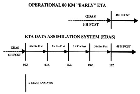
FIGURE 3.1 Data assimilation cycle for the Eta model. The early forecast is initialized from the GDAS. The Eta model currently allows 12 additional hours of spin-up. A continuously cycled data assimilation system has been developed for the Eta model and is undergoing final testing. Note: FCST = forecast; OI = optimal interpolation.
(EDAS) (see Rogers et al., 1996) and NOAA's MAPS (see Bleck and Benjamin, 1993; Benjamin et al., 1996) will deliver analysis products to GCIP. (It should be noted that MAPS is the experimental version of the model used for the NCEP Rapid Update Cycle Prediction.) The Canadian RFE (see Ritchie, 1991), used in the companion Canadian MAGS project, will also support GCIP objectives. For the first time, investigators will be able to analyze regional features at high resolution over a continent-scale domain on climatic time scales. This is a very timely development, when one considers the advent of high-resolution satellite measurements in the next century.
The RFE and EDAS regional analyses are currently initialized from the global analysis. However, since April 1, 1995 (GCIP archives), EDAS has allowed some additional time for the regional model to adjust the fast processes (e.g., convection) in the atmosphere. As shown in Figure 3.1, each EDAS execution spans a 12-hour assimilation period (four 3-hour cycles) that begins with a ''guess" from the GDASs and ends with a 48-hour Eta model forecast from the final EDAS analysis. During this 12-hour cycle, EDAS assimilates a considerable variety of new data not incorporated in GDAS. In addition to surface stations, EDAS assimilates wind data from the radar profiler network in the central United States and automated observations of wind on commercial aircraft,
known as ACARS (Automated Communication and Recording System) data. Recently, the assimilation of Special Sensor Microwave Imager (SSM/I) derived total column water vapor over oceans was implemented, to be followed in 1996 by the assimilation of GOES-derived water vapor profiles in clear areas over land and ocean.
In contrast to the current EDAS, the MAPS regional analysis system uses a continuous assimilation cycle for surface as well as atmospheric variables. MAPS currently uses all available surface data, aircraft observations (including temperatures), profiler (both the NOAA network and a number of boundary-layer profiles), radioacoustic sensing system (RASS) temperature profiles, and the horizontal velocity azimuth display (VAD) winds from the WSR-88D radars. These data are assimilated in an ongoing 3-hour cycle (which was changed recently to 1 hour). MAPS is also using a five-level soil vegetation model, and additional enhancements to most physical parameterizations are about to be implemented (Smirnova et al., 1996, 1997a). MAPS has a land surface scheme similar to the ETA model, and because of the continuous cycling the GCIP data base will now contain a regional-scale land surface-assimilated data set. A similar continuous assimilation cycle for EDAS is currently being introduced into operations.
Besides developing the regional analysis archives, GCIP was the driving force for developing useful augmentations to these model output products. In particular, a number of reduced data sets are being archived along with the full three-dimensional products. Model Output Location Time Series (MOLTS) will provide hourly time records of various model outputs at some 300 "station" sites (Figure 3.2). These products include time series of vertical latent heating and radiative heating profiles, soil moisture, soil temperature, precipitation, runoff, evaporation, snowmelt, and more. Many of these model sites are coincident with radiosonde sites. Another reduced data set is the Model Output Reduced Data Set (MORDS), which will provide vertical sums of the atmospheric budget variables as well as low-level atmospheric variables that interact with surface variables on a common 50-km grid. Also included in MORDS are horizontal slices at several atmospheric levels. This unprecedented level of postprocessing in the archives means that many researchers will now be able to effectively examine critical subsets of the gigabyte-to-terabyte archives associated with modern analysis systems without having to do an inordinate amounts of preprocessing themselves.
Land Data Assimilation System
The increase in spatial resolution in regional analysis models has affected the kinds of processes incorporated into both analysis and forecast models. Studies have begun to demonstrate the importance of surface inhomogeneities (gradients of soil moisture, vegetation type, soil type, cloudiness, and resulting surface temperature variations) in triggering mesoscale circulations. Such mesoscale circulations are often particularly important for initiating convection. Moreover
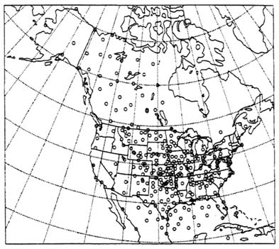
FIGURE 3.2 Geographic distribution of 300 MOLTS locations. Locations include all standard radiosonde and surface observations as well as derived quantities including vertical profiles of radiative and convective heating and latent heat release.
surface characteristics, especially soil moisture, may vary significantly over periods of only a few hours and influence the atmospheric circulation on the same time scale. In fact, assimilation systems are beginning to resolve scales at which surface influences are often equivalent to or even more significant than dynamical interactions in the general circulation of the free atmosphere. As discussed in Chapter 2, GCIP accelerated this recognition of the importance of land surface processes in weather and climate predictions.
In particular, GCIP provided the framework for developing companion Land Data Analysis Systems (LDASs) (K. Mitchell, personal communication, 1996). An LDAS is the land surface-hydrological component of the regional models that could be forced by observed or model fields and could cycle continuously on itself. Gridded precipitation fields provided by the precipitation analysis discussed below and hourly half-degree surface radiation fluxes inferred by the National Environmental Satellite Data and Information Service (NESDIS) from operational GOES-8 satellite observations could be used in place of model-predicted fields. Near-surface winds, humidity, and temperature data, which are
needed as inputs to compute surface sensible and latent heat fluxes, could be provided by the regional models as well as observations. An independent LDAS could thus provide estimates of soil moisture, surface evaporation, surface sensible heat flux, and runoff that should prove to be more reliable than those generated by the operational assimilation schemes for the same surface variables. The LDAS could also be used to explore land surface climate scenarios available from GCMs. LDASs also form a potential bridge from LSP models of global general circulation models to hydrologic models of operational hydrology. It should be noted that a model-driven LDAS has been running in MAPS since April 1996 (Smirnova et al., 1997b).
Precipitation
GCIP also helped initiate the NCEP-OH (NOAA Office of Hydrology) operational national 4-km hourly precipitation analysis. This analysis is derived from the new WSR-88D (NEXRAD) radar-based precipitation estimates and hourly rain gauge observations combined by a multisensor precipitation analysis algorithm. This algorithm was developed initially for the regional OH River Forecast Centers. Through the efforts of NCEP and OH to develop centralized access to this information nationwide and through the work of Seo (1998a,b), the Hourly National Precipitation Analysis became available in real time on an experimental basis in May 1996. The experimental product shown in Figure 3.3 includes (1) a merged gauge-radar product; (2) a companion gauge-only product; (3) a companion radar-only product; and (4) a companion NESDIS GOES satellite-only product (Baldwin and Mitchell, 1996).
This high-resolution precipitation product is also being tested as a possible input to the Eta model assimilation. For example, Lin et al. (1997) showed that by incorporating precipitation and its influence on latent heating, subsequent predicted precipitation amounts as well as other model variables are improved.
RECOMMENDATIONS
GCIP is developing a comprehensive set of regional analysis archives from three regional analysis systems (Eta, MAPS, RFE). However, these regional archives are likely to be highly model dependent and must be compared with each other as well as with global analyses and field observations. Surface products will be one of the most innovative and potentially most problematic regional analysis outputs. These surface products need special attention, including comparison to output from hydrologic models and LDASs. LDAS simulations are just beginning and also require special attention. Finally, given all the scientific developments that will occur in the development of analyses for these surface and atmospheric variables, including longwave radiation and precipitation, it is especially
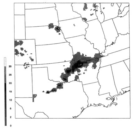
FIGURE 3.3 One-hour precipitation accumulation (mm) over the south central United States valid at 04 GMT, September 24, 1996, from the hourly 4-km multisensor gauge-radar NCEP National Precipitation Analysis (NPA). Only about one fourth of the NPA domain is depicted.
important that GCIP begins to plan for an eventual reanalysis of its products. Specific recommendations relevant to these and related issues are discussed below.
Archive and Develop GCIP Analyses and Forecasts for Comparison with GCM Simulations, Global Analyses, and Field Observations
Regional analysis systems being developed for limited-area NWP have great potential to assimilate data from high-resolution weather observing systems coming on-line in the near future over the United States. However, we need to know whether significant improvements result from current regional models or whether
even higher resolution is required to provide noticeable impacts. Comparisons to global analysis products would be useful. Comparison to a range of observations, especially surface flux data, PBL profile data, and shelter-level temperature and dew point data from field projects such as FIFE (see Betts et al., 1993), HAPEX, SURFRAD, ARM-CART (see Charlock and Alberta, 1995), VORTEX, CASES, and BOREAS, could also be utilized to validate the regional 4DDA outputs. Additional data, such as satellite-derived surface skin temperatures, are being utilized at NCEP for model validation. Also, numerous surface measurements from cooperative stations that are not transmitted in time for incorporation into the operational analysis could also be compared to analyzed products.
Another problem is that the constant insertion of data into the analysis process keeps the analyzed climatological fields close to observations. However, the consequence of these frequent corrections is that the model increments or tendency terms are neither small nor random, and are sometimes dominant in regional hydrologic budgets (see Kanamitsu and Saha, 1996; Roads et al., 1998a). Although different model errors may compensate in different regions, reducing analysis increments in all regions is one clear measure of the quality of the model used for data assimilation (Roads et al., 1998b). It is important that this objective measure of analysis quality be retained in the archive. In addition, before GCIP, most climatological budgets were calculated twice a day from instantaneous analyzed fields. Nonlinear terms could be seriously aliased in this procedure, producing considerable errors in atmospheric water and energy budgets derived from instantaneous model output every few hours. Budget quantities should be accumulated at every time step and output values provided several times a day. Such cumulative results often combine contributions from several processes. It is important to keep separate accounts of these different contributions, since they cannot be unraveled afterward (except by redoing most of the original computation). For example, it would be important to archive horizontal and vertical advection terms, as well as implicit sub-grid-scale cumulus and planetary boundary-layer advection terms.
Analysis increments provide a description of some but not all regional model biases. Longer-term differences are not currently known since few regional models have been run for long time periods. It would be useful to run regional models for longer periods, like GCMs, to determine the characteristic time scales of the processes, especially processes at the land surface. In fact, one of the primary goals of GCIP is to show that improved modeling of the land surface-atmosphere interface in regional coupled models will improve predictions of weather and climate on a broad range of time scales from the diurnal to interannual. Some GCIP research has provided tantalizing evidence for this capability (Roads et al., 1998a), but more needs to be done. This research can be done initially with GCMs, but eventually it would be useful to determine how the heterogeneity of the land surface at GCIP scales contributes to the overall variability and predictability of atmospheric variables, including precipitation.
Diagnostic studies of rain-producing processes in limited-area and mesoscale model analyses are also needed to address another important aspect of GCIP science. The characteristics of convection and the vertical structure of rainclouds in various regional models are clearly different, and the GCIP community needs to understand how precipitation forms in these models and what the hydrologic balances are once it is formed. Understanding the vertical structure of the energy and water budgets and how they are treated in analyses as well as GCMs would be helpful for eventually developing better parameterizations for moist convection and boundary-layer processes. Developing a better understanding of precipitation characteristics would also lead to improved utilization of precipitation data as input to new atmospheric analysis schemes.
Develop and Distribute High-Resolution LDAS Products and Models
A completely satisfactory high-resolution land surface initialization scheme has not yet been developed for regional models. As mentioned previously, the EDAS and RFE analyses are currently initialized from coarse global analyses. The impact of using such coarse global initializations, especially for the land surface, is unknown but potentially important because of the long time scales inherent in land surface processes. It is essential that regional analysis models have their own land surface initialization, independently from a global model analysis, to permit the assimilation of high-resolution GCIP observations, rather than reinitializing from global analyses.
Much of the initial work on the stand-alone initialization of the land surface component of regional models can be carried out through LDAS studies. LDASs may also provide a promising approach to optimally determine land surface characteristics from available (incomplete) observations. Snow, soil (and perhaps lake), and vegetation water storage could eventually be part of the system. It is important to undertake an LDAS experiment with higher-resolution models as well as hydrologic refinements, especially with regards to the simulation of runoff. Although several problems remain to be solved, including anthropogenic influences on river flow through various water diversion projects (e.g., dams), a runoff model would be a definite step toward fulfilling GCIP's goal of developing a continental hydrologic information system, similar to the existing global weather information systems.
LDASs do not provide the coupling that may eventually be needed to properly represent land surface effects. Indirect methods, such as comparing weather predictions based on land surface analyses from LDAS and regional models, should be tested. For example, one could expect that the structure of the planetary boundary layer as well as atmospheric convection would be affected strongly by different initialization schemes for land variables. Basically, there is much to be learned from LDAS products, and the various regional centers producing such analyses should develop a dialogue with users that could exploit subsets of the
data for testing future land surface and regional model schemes. Critical to this effort is the development of a GCIP data base of gridded data that could be used to force the LDAS systems.
Develop a Strategy to Facilitate Future Reanalyses of GCIP Data
Problems arise when using operational analyses to describe climate and climate variations because of successive upgrades to the analysis systems. Operational analysis systems are constantly being modified and improvements being implemented. For example, the optimal interpolation schemes used in EDAS and MAPS will be replaced next year with a three-dimensional variational analysis method, which will allow, in particular, the direct incorporation of satellite water vapor radiance data (McNally and Vesperini, 1996) and eventually other remote sensing variables such as radar reflectivity and global positioning system (GPS) signal data. It is important that these changes in analysis technique be clearly documented and in the archives. We need to know whether significant changes are due to climatic events or model enhancements.
Despite documentation of improvements in the analysis scheme, discontinuities and artificial jumps in the climatic record will impair the usefulness of GCIP analysis products for the study of long-term climate variations. Already, several global reanalysis programs are under way in an effort to produce consistent multiyear records of coarse-scale atmospheric and surface fields. Although the quality of data inputs may vary, these projects will at least use a consistent procedure to reanalyze data from the recent past. The GCIP archives should be organized so as to allow similar reanalyses. Combined global-mesoscale re-analysis systems could be an effective tool to investigate the relative influence of factors such as topography resolution, land surface physics, different observing techniques, precipitation, and temperature anomalies.
Other products would also benefit from a well-conceived reanalysis plan. For example, given that GCIP's 4-km precipitation analysis is produced in an operational (not research) context, it is essential to allow for a posterior improvements of these archived operational rainfall estimates. Merging various precipitation data is also problematic as we infer area-averaged estimates (100 km2) from kilometer-scale NEXRAD observations. Separate archiving of model-generated, gauge, radar (including separate components of the radar as well as the merged radar products), and satellite data sets is a requirement for assessing and eventually improving their quality. This is especially important for wintertime precipitation estimates, which are known to have large observational errors in both gauge and radar products (Groisman and Legates, 1994).


