
4
Data Collection and Management
Provide access to comprehensive in situ, remote sensing, and model output data sets for use in GCIP research and as a benchmark for future studies.
BACKGROUND
Over the Mississippi, weather and climate observations are made hourly or even more frequently depending on the particular weather situation or the particular observational system. Such frequent observations are obtained from pressure and temperature sensors and hygrometers in instrument shelters 2 m above the ground surface, from wind anemometers 10 m above the ground surface, from precipitation gauges at heights 1–2 m above the surface, and from stream gauges. Observations are made less frequently in the upper atmosphere by ascending radiosondes with temperature and moisture sensors, and remotely by radar and satellite-borne sensors. There also are new or less common instruments, such as the Automated Surface Observing System (ASOS), atmospheric profilers, weather radars, and satellite-borne sensors. In some cases a variable is measured directly (e.g., precipitation total from a precipitation gauge), whereas in other cases a value is estimated by interpreting a remotely sensed signal (e.g., continental estimates of snowcover from satellite radiance data). Many of the observations are made as part of a meteorological or hydrological network and are available in real time over the Global Telecommunications System (GTS), the primary source of data for the world's NWP centers.
ACCOMPLISHMENTS
Special Data Sets
The kinds of data available to GCIP efforts are illustrated by the data sets gathered for the fourth GCIP Initial Data Set (GIDS-4). These data were collected
during the April to September 1995 Enhanced Seasonal Observing Period (ESOP-95) and include surface data from a variety of federal and state agencies, upper-air data, radar data, land characterization data, satellite data, and model output data. Additional ESOPs are being planned as GCIP emphasis moves from LSA-Southwest toward LSA-North Central, LSA-East, and eventually LSA-Northwest. The types of ESOP data gathered and disseminated will vary depending on data availability and needs within LSAs. For example, snow depth and areal extent measurements will be a special emphasis of the north central ESOP.
Most of the GIDS-4 data were collected by the University Corporation for Atmospheric Research (UCAR) Joint Office for Science Support (formerly known as the Office for Field Project Support) from existing data collection systems, although several unique data sets were derived from or supplement standard data (e.g., GIDS hourly and daily composites of precipitation and surface observations). ESOP-95 was also coordinated with the VORTEX project, and project data from both initiatives are available to all researchers. This combined data collection exemplifies the character of the climatological GCIP effort; GCIP is not planning specific field campaigns but instead intends to augment the GCIP continental and climatological perspective with data from individual field programs. Especially noteworthy is the successful cooperative data arrangement with the DOE's Atmospheric Radiation Measurement program, which will be included in the standard and LSA-SW ESOP data sets compiled for GCIP.
The GCIP Reference Data Set (GREDS) has been widely disseminated. GREDS includes a considerable amount of relevant background information, broadly characterized as data that will change little if at all during the next several years. This includes information on the physical geography of the GCIP region, along with cartographic information. GCIP is supporting additional efforts for characterizing soil physical and hydraulic properties. A soils data set is being developed from the U.S. Department of Agriculture (USDA) National Resource Conservation Service (NRCS) State Soil Geographic Database (STATSGO) and the county-level Soil Survey Geographic Database (SSURGO). This data set covers the 48 conterminous United States at a resolution of 1 km and contains information on texture, depth to bedrock, particle size distribution, rock fragment class and volume, porosity, hydrologic soil groups, and available water capacity. These data sets not only are useful to GCIP but also are useful to a wide variety of interdisciplinary studies.
Another retrospective data project being developed consists of pertinent data from two abnormal climatic events, the 1998 drought and the 1993 floods in the Mississippi River basin, which occurred just as GCIP was beginning its data collection efforts. These data will be used in conjunction with regional modeling efforts designed to understand these extreme events. Future data projects will include compiling high-quality hydrometeorologic data for even longer time periods (e.g., 30 years) to put ESOP and Enhanced Observing Period (EOP) data in their climatologic context and to assess the impact of climate variability on water
resources. Data will include such variables as precipitation, air temperature, streamflow, and other available meteorological observations.
Four-Dimensional Data Assimilation Products
Model-derived four-dimensional data assimilation output for the GCIP program is being gathered from a number of atmospheric and hydrologic assimilation systems of various resolutions and with differing physics and data assimilation methodologies. Products are obtained from these global 4DDA systems, run by NOAA and Canada. Three principal mesoscale 4DDA systems used by GCIP are the NOAA-NCEP EDAS, the NOAA Forecast Systems Laboratory (FSL) MAPS, and the Atmospheric Environmental Service-Canadian Meteorological Centre (AES-CMC) RFE analysis system.
Although the full model outputs will be available, their very large volume (terabytes) will prohibit full examination by most users. Because of the immensity of these data holdings, GCIP is making a special effort to disseminate the essence of model output data. Postprocessed 4DDA output is available in two special GCIP data sets: (1) one-dimensional vertical profiles and surface time series at selected locations (MOLTS), and (2) gridded two-dimensional fields, especially ground surface state and flux fields and top-of-the-atmosphere flux fields (MORDS). Subdividing the 4DDA output into these component parts greatly facilitates dissemination of data sets to users. Forecast fields are also being archived and made available. As discussed in Chapter 3, forecast diagnostics are especially valuable in understanding how models adjust from initial conditions to conditions that are more compatible with the model physics.
Data Management and Service System
The GCIP project office is compiling information on data and metadata as they are collected at different centers, rather than assembling the information at one location (Figure 4.1). By directly accessing a distributed center, a user also receives further specialized information on the data sets (e.g., formats, metadata) directly from the source. This distributed data management approach minimizes the lag time before data are available to scientists.
The GCIP Home Page on the World Wide Web (http://www.ogp.noaa.gov/gcip) serves as the focal point for the Data Management and Service System (DMSS). This location is intended to provide links to existing directories such as NASA's Global Change Master Directory (GCMD) or to provide special facilities developed for the GCIP-DMSS to expedite data searches. DMSS facilities also provide information on experiment status, documentation, and references.
The DMSS consists of four primary data modules. The in situ data module provides data management and information resources for surface, upper-air, radar, and land surface characteristics using the UCAR Office of Field Project
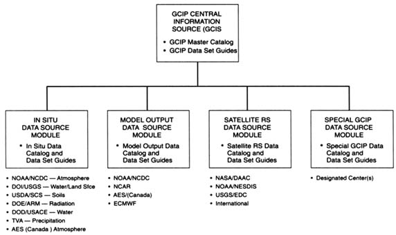
Support's Cooperative Distributed Interactive Atmospheric Catalog and the NOAA National Climatic Data Center's (NCDC) On-Line Access and Service Information System. Currently, data from the GIDS-1 and GCIP Integrated Systems Test (GIST) sets are available on-line, and data sites such as NCDC, DOE-ARM, and AES may be accessed. Activities planned for this module over the next several years include the following: (1) collecting data during the five-year EOP (1996–2000), including the ESOPs during this period; (2) providing ''quick response" data sets (i.e., two-month lag) to the GCIP community; (3) continuing to provide GCIP data sets via on-line access and compact disk, read-only memory (CD-ROM); and (4) continuing to develop WWW enhancements to the module and establish links to other data centers and data sets.
The model output data module uses the NCAR Scientific Data Services as the infrastructure. Data sets provided by this module include output from the National Meteorological Center's (NMC's) numerical weather prediction model (Eta model) and its associated four-dimensional EDAS. All EDAS output is archived at NCAR. During the next several years RFE output from AES and MAPS output from NOAA-FSL will also be available through this module. MOLTS and MORDS will likewise be available here.
The satellite data module provides links to sites with remote sensing data sets. These include NOAA's NESDIS, the U.S. Geological Survey (USGS) Earth Resources Observation Satellite Data Center (EDC), and various international centers. It also previously provided a link to NASA's Data Acquisition and Archive Center (DAAC) at Marshal Space Flight Center. Work continues on improving the satellite data module, including compiling information about the GCIP data requirements and coordinating readily available data sets specified by principal research areas.
RECOMMENDATIONS
The GCIP data collection and management effort should add a scientific users' group to identify data sets of highest priority to GCIP researchers. The scientific users' group should recommend methods for the efficient archiving and reprocessing of high-volume NEXRAD data for climatological precipitation estimates. Methods to archive and access research data, especially remote sensing data sets created by individual GCIP scientists, also should be addressed. Specific recommendations relevant to these and related issues are discussed below.
Establish a Scientific Users' Group to Identify Priorities for the Data Sets Required to Achieve GCIP Scientific Goals—An Important Task for This Group is to Recommend an Archival Strategy for NEXRAD Data So That These Data Can Be Reprocessed Efficiently
The existing GCIP Data Collection and Management (DACOM) has done a commendable job of organizing the archiving of data sets, but now that GCIP is
moving onto specific LSAs, it is important that science issues be the driving force for acquiring, archiving, and disseminating new GCIP data sets. This is the best way to ensure that GCIP science objectives are met.
The GCIP DMSS relies on the operational archives for very high data rate products, particularly raw data from the NEXRAD system for precipitation estimation. In fact, one of the prime drivers for GCIP being located in the Mississippi basin was the availability of data from these radars. Although these data are being archived, they are archived on an operational basis not designed for reprocessing of long time series of data from many radar sites. Retrieving a long time series of NEXRAD data from many sites is prohibitively expensive for GCIP or any other research project. The highest priority of this user's group should be to identify the levels of processing required, quality control issues, and practical schemes for the production, dissemination, and reprocessing of NEXRAD data.
Give Additional Attention to the Production, Archiving, and Dissemination of Remote Sensing Information
The GCIP-distributed DMSS relies heavily on operational systems subject to constraints and sometimes does not include GCIP data sets. Products that have not been derived as part of the operational system are not required to be archived and thus are not easily accessible through DMSS. The panel is particularly concerned that the Marshall Space Flight Center's DAAC has been closed, and no center has been identified to take over its responsibilities. Remote sensing information would be especially useful in supplementing in situ and model simulation data. In fact, some remote sensing information, such as the Normalized Difference Vegetation Index (NDVI) and snowcover, would be very useful in supplementing the in situ and model-assimilated data as more elaborate algorithms are developed to infer other land surface variables.
Investigate the Feasibility of Collecting Available Hydroclimatological Observations from Experimental Sites in Near Real Time
Field programs such as ARM, FIFE, and BOREAS have been invaluable for improving the quality of the models and data assimilation systems. However, except for the ARM site, no such data are available to the GCIP project as part of its standard operational archives. The information collected by these programs includes surface energy fluxes, soil moisture profiles, soil temperature profiles, planetary boundary-layer fluxes measured from towers, surface radiation measurements, and so forth, over the entire Mississippi basin. These flux measurements are a valuable resource for better parameterization of the surface and planetary boundary layers and for assimilation into operational models.


