
1
Introduction
The Threat of Natural Disasters
Natural disasters threaten much of the United States. In the past decade, substantial losses were experienced from the Loma Prieta earthquake and Hurricane Hugo in 1989; Hurricane Andrew in Florida in 1992; the Mid-west floods in 1993; the Northridge, California, earthquake in 1994; and Hurricane Georges, the Florida fires, and the Texas floods in 1998. In recent years the cost to the nation of natural disasters has been huge, with many hundreds of deaths and tens of billions of dollars in damages (NRC, 1994). The impacts are felt not only by human suffering and property damage but also from loss of livelihood, economic deterioration, and environmental destruction. A large part of the costs of these disasters has fallen on the federal treasury, as well as state and local governments. These and other recent natural disasters also have had a serious impact on the private sector, most notably the insurance industry. Some companies have deemed it necessary to limit the coverage they provide in order to maintain their fiscal strength and to protect policyholders. Indeed, in certain cases they have withdrawn from the market entirely. For example, the states of California and Florida have established special catastrophe funds to assure that property owners continue to have access to insurance coverage.
Unfortunately, several factors may contribute to even greater losses in the future. For example, there has been a steady migration of people to coastal areas, where risks are substantially higher for hurricanes along the Atlantic and Gulf coasts and for earthquakes along the Pacific Coast. Similarly, the continuing movement to urban areas—our communication, transportation, financial, and government hubs—greatly intensifies the potential scale of private and public losses from natural disasters. Furthermore, exposure to hazards in many of the nation's floodplains increases the risks, owing to development and modifications to the landscape.
Reducing Disaster Losses.
Although losses from past natural disasters have been substantial, they have been far less than they might have been. Various strategies for mitigating losses have been progressively implemented with some very impressive results (NRC, 1994, 1997). For example, improved weather warning systems have resulted in reduced loss of life from hurricanes and floods (NRC, 1998a). Unfortunately, this stands in contrast to the great increase in property damage. Also, better land-use and construction practices have reduced earthquake and flood losses (NRC, 1994).
Disaster decision-making takes place before, during, and after a disaster strikes. The phases of decision-making are usually described as mitigation, preparedness, response, and recovery. Mitigation involves long-term actions to prevent or reduce a hazardous effect from occurring, such as building structures that can withstand the force of winds or earthquakes. Preparedness anticipates the effects and takes appropriate countermeasures in advance, such as issuing warnings, stockpiling supplies, or establishing evacuation routes. Response includes actions taken during an event and its immediate aftermath, including rescue. And recovery brings a community back to life by restoring essential services and economic vitality. A recent
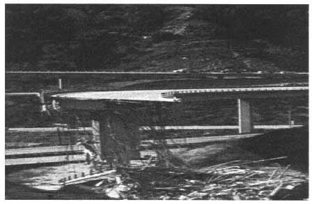
The Interstate 5/Route 14 interchange, north of Los Angeles, was one of only seven overpasses to collapse in the devastating 1994 Northridge earthquake. Hazard maps helped the California Department of Transportation decide which freeways should have priority for seismic strengthening. (Photo courtesy of USGS.)
report by the Federal Emergency Management Agency (FEMA, 1997) provides a comprehensive overview of natural hazards and approaches to understanding the risks posed and to mitigating their impacts.
Importance of Information for Decision Making
At each phase of the disaster management cycle of mitigation, preparedness, response, and recovery, critical decisions must be made that require getting the right information to the right people at the right time. These decisions are made in both the public and the private sectors and often at local or individual levels. In the public arena, much responsibility rests with the local community that has jurisdiction over public safety and land-use, although the community is usually backed up by state and federal assistance.
At present, several federal agencies and other organizations perform a variety of functions relevant to development and communication of information about natural disasters. These functions encompass broad areas of data collection, risk analysis, research, and information dissemination. In a predisaster (or preparedness/mitigation) period the information-producing organizations may collect and manage baseline data; construct predictive models; develop new modeling, data analysis, and instrumentation methods; and help communicate hazard information to user groups through maps, reports, public contacts, and other means. During the response phase (or during the occurrence of an extreme event) the agencies collect and manage real-time data and communicate hazard information, such as in warnings. In the recovery period after an event, the agencies document what happened with the goal of understanding why the event occurred and identifying problems in modeling, data collection, and understanding physical processes. The information and experience gained through these functions is communicated to planners and managers and should enhance and improve understanding of extreme events and make communities better prepared for future events.
As discussed by the Global Disaster Information Network (GDIN) Task Force (DITF, 1997), a fundamental problem in dealing with disasters is that they do not respect boundaries—organizational, political, geographic, professional, topical, or sociological. This complexity requires that disaster information be disseminated to all stakeholders involved in the disaster at hand, and each disaster may have a unique set of stakeholders. Furthermore, in developing the information there is a need to integrate data across many disciplines, organizations, and geographical regions. Representatives from various sectors of disaster management, therefore, must be involved in the design and integration of any new information system.
Parallel with the urbanization and growing complexity of American demography is the rapid advance of technology and information systems. The potential for access to data and the ability to produce derivative information are unprecedented. This trend can be seen in the expanded use and number of space-based sensors, the explosive expansion of communications channels, and the exponential rise in computers connected to the Internet. There has also been tremendous growth in the use of geographic information systems, the Global Positioning System, and modeling and simulation techniques. Each adds significant value in monitoring and simulating events and in characterizing infrastructure, high-hazard areas, and disaster zones, which is essential to rapidly bring scarce resources to bear in the most effective manner in both pre-and postdisaster contexts.
Despite technological advances, disaster risk continues to grow. Emergency managers and others continue to be called on to make decisions during disaster events, as well as in the pre-and postdisaster phases, with incomplete information. In order to make optimal decisions to reduce the loss of life and property, stakeholders uniformly must be able to obtain the needed information in a format that is appropriate for their capabilities.
The availability of information relevant to disasters is greater than ever before. Hundreds of federal, state, local, and international public and private organizations have created databases, largely accessible through the Internet, that are rich in information and knowledge. One can view data within seconds of its collection to, for example, see how a river is rising (see Box 1-1), track a tornado or hurricane, or observe the likely extent of damage caused by an earthquake that has just occurred; also, one can access the latest information on disaster-resistant designs, regions of high and low risk, sources of emergency supplies, preparedness plans, and more. While reliability during periods of great demand is still an obstacle to be overcome, the Internet and World Wide Web make it possible for millions of people to share data and information and to work together in ways not previously possible. Furthermore, it is anticipated that future advances in the Internet will increase reliability, speed, and access to information at lower cost (U.S. Department of Commerce, 1998).
Why the Present Situation is Inadequate
Disaster managers and other decision makers currently utilize a wide variety of information in all stages of the disaster management cycle of preparedness, mitigation, response, and recovery. However, the information resources that are available are often inadequate. First, the availability of information across the United States is not uniform. Large cities may
|
BOX 1-1 Increased Access to Streamflow and Stage Information The role of the U.S. Geological Survey (USGS) in providing information on hydrological hazards has changed dramatically in the past several decades, driven largely by rapidly evolving information technologies, and provides a good example of how information on hazards has become widely available almost instantaneously. The primary customers for hydrological data and related information in the first two-thirds of the twentieth century were the agencies and organizations responsible for developing the nation's water resources infrastructure. The products that the USGS provided during this period were historical streamflow data and some analyses of data related to water supply risks, reservoir safe yields, and flood frequency determinations. The National Weather Service installed instruments in many USGS stream gaging stations for transmitting river stage data via landline to its forecast offices. The USGS did not transmit real-time data directly to any organization. Hazards information, such as streamflow data, has become widely available almost instantaneously with new collection, transmission, and dissemination technologies. The agency's role began to change in the 1950s and 1960s as streamflow monitoring expanded to support reservoir operations and other real-time purposes. Streamflow data during this period were provided primarily in printed form, with provisional real-time data available to specialized users. The typical mode of data transfer to USGS customers in the 1970s is depicted in Figure 1-1. In the 1980s and 1990s the agency's traditional customer base expanded significantly. Organizations supporting operation of the stream gaging program have included city and county agencies that need information for many different purposes, including flood hazard warning. Today, more than 800 agencies support the stream gaging program and at least two-thirds of them are local government agencies. This change in the USGS customer base coincided with dramatic improvements in the quality and cost effectiveness of satellite and microprocessor technologies available for data management and dissemination. Instead of recording data on paper |
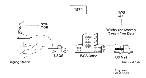 Figure 1-1 USGS's mode of hydrological data collection and dissemination in 1970. 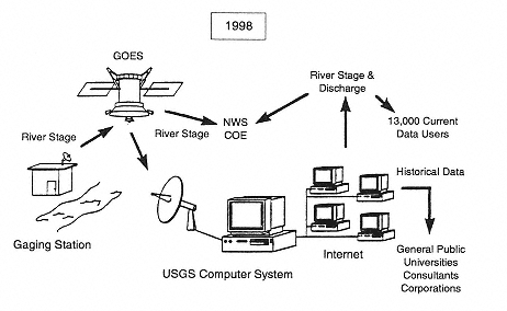 Figure 1-2 State-of-the-art mode of hydrological data collection and dissemination for USGS in 1998. charts or punched paper tapes, the USGS began storing data on small storage modules, downloading data to field computers for automatic processing, and transmitting data from field sites via the GOES satellite network, as shown in Figure 1-2. The satellite capability has enabled the USGS to transmit, process, and disseminate both river stage and discharge data every few hours to its customers who need the information for emergency warning and response functions. |
have invested millions of dollars in their information systems, while smaller municipalities may be operating with one personal computer, if that.
In addition, the mechanisms to bring data and information to decision makers are uncoordinated. Information is often produced from disparate sources and transmitted in whatever format the provider prefers, requiring significant effort to compile it into a form that provides a coherent picture or even thwarting integration altogether. Data standards are often inconsistent, and, even more dangerous, users are sometimes unaware of the limitations and uncertainties in data or are presented with conflicting interpretations of data without the means to assess the reliability of the sources. All of these issues reduce the efficacy of the decision-making process. The problem is compounded because information delivery systems in many cases become overloaded during crises. For instance, in 1996 a moderate (magnitude 4.7) earthquake in San Jose, California, led to more than a million attempted hits in less than one day on the U.S. Geological Survey's World Wide Web earthquake information server. Most of those attempts were unsuccessful, including those by emergency managers trying to access data and information to aid in the formulation of a response plan.
Along with the technical difficulties for accessing information and data reliability, impediments arise from the lack of interaction between users and providers of information. Many of the data are created through research or monitoring programs that do not have disaster management as part of their mission. The users of such data are passive receivers of information without a role in requesting particular types of data. No entity exists to coordinate or foster communication among these groups. Nevertheless, a wealth of information exists that is potentially invaluable to users in the private sector and local and state governments (see Appendix B, which lists 31 federal disaster information centers).
The need for improved disaster management information is clear. The question at hand is: How could a nationally organized effort best meet this national need?
What is a Disaster Information Network (DIN)?
A DIN would promote understanding, cooperation, coordination, and collaboration among the providers and users of disaster information. It should be noted that a DIN would not be a central database or a network like a telephone or computer network; instead, it would be a comprehensive activity relating all aspects of disaster information, including accessing information resources, producing derivative and integrative information products, and delivering the information to decision makers of all types in a
timely and useful manner. The process would draw on many existing resources and capabilities. Some features of a DIN should include:
- improved methods for finding information with specific attributes, for example, for a particular area or type of hazard;
- ways to determine the source, quality, and reliability of information, including standards for data compatibility;
- systems or software for integrating information rapidly to produce and deliver information tailored to the needs of a decision maker for the specific problem at hand; and
- courses to train users and build awareness.
Much of the DIN focus should be on developing integrative products for decision makers. Top priority should be accorded this area because the wealth of information that resides in numerous databases cannot be readily utilized by those who must take action to reduce risks or respond to disaster losses. A few examples, from many that could be cited, of integrative products are:
- international, national, regional, or local maps showing how hazards and risks vary in space and time;
- estimates of probability of occurrence of hazardous events;
- estimates and examples of potential effects, especially for structures;
- real-time display of what is happening during the course of a disaster;
- systems for contingency planning; and
- codes, standards, and construction methods for structures.
The overall goal of a DIN should be to reduce disaster losses. This can only be achieved by building communities that are resilient to the impacts of disasters. With limited resources, community decision makers need the best information they can get on what the hazards are, how likely they are to occur, what is at risk, how the effects vary throughout a community, and what can be done to mitigate the impacts. Much of the basic data from which this information would be derived is available now; however, the process for making available information products appropriate for decision makers needs to be developed.


