
1
Introduction
Hydrologic hazards of various types present myriad technical and public policy challenges in the United States and worldwide and are defined as extreme events associated with water occurrence, movement, and distribution. Specifically, hydrologic hazards include flooding and related events (e.g., landslides and river scour and deposition) and droughts; coastal flooding and related phenomena are not included. In the United States, about 7 percent of the land area is subject to flooding, about one-third of the nation's streams experience severe erosion problems, landslides and mud slides are commonplace in some areas, and virtually all of the nation is susceptible to drought. Floods are generally regarded as the most significant of hydrologic hazards, with losses amounting to over $2.5 billion in direct damages and nearly 100 lives lost annually (FIFMTF, 1992). Hydrologic hazards can have sudden adverse effects on many people, including threats to public safety and costly interference with commerce. There is a continuing need for monitoring, regional studies, and research on hydrologic hazards in order to better understand physical processes, inform improved decision making, and ultimately help lessen the impacts of hydrologic hazards.
Hydrologic hazards are the focus of important activities carried out by the U.S. Geological Survey (USGS), including:
- Monitoring of streamflows to support the efforts of other organizations engaged in operations such as flood forecasting and reservoir management and the provision of information during emergency conditions.
- Interpretive studies to improve understanding of the hydrologic characteristics of floods and droughts.
- Research and technique development concerning topics such as frequency analysis of extreme events to support planning of hydraulic structures and floodplain delineation and management, hydrologic modeling, paleoflood and hydroclimatic investigations, and scour analyses.
Much of the work performed by the USGS Water Resources Division has focused on developing and providing information to help minimize the uncertainties and lessen impacts associated with hydrologic hazards. Monitoring activities, in particular, provide the foundation for significant hydrologic hazards-related work performed by other agencies, including planning, forecasting, and emergency response.
Given the importance of hydrologic hazard information, the USGS seeks to continually improve its approaches, techniques, and products. The agency must also ensure that its work is focused on the most significant issues and that it provides information to address contemporary needs of other agencies and the public. In that regard, the objective of this report is to provide strategic guidance to the USGS on its hydrologic hazards research program. A number of broad questions stimulated and shaped the committee's deliberations that form the basis for this report. These questions, though not all of equal importance, are grouped below according to similar types of activity:
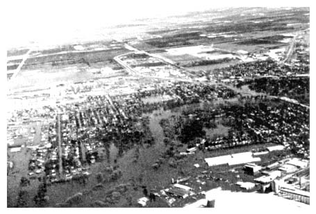
Aerial view of flooding in Grand Forks, ND, during spring of 1997.
Photo courtesy of U.S. Geological Survey.
- What are the flood and drought information needs of USGS cooperators and others? What constitutes an adequate national stream gaging network for hydrologic hazard analyses and warnings? What should the USGS be doing to apply hydroclimatic understanding to produce improved hydrologic hazard information? How can the USGS account for multiple hazard events, particularly regional characterization of risk?
- What are important national needs for hydrologic hazard research by the USGS? For example, are current approaches for estimation of flood frequencies and for characterizing drought in need of improvement? What should be the focus of the agency's programs related to river scour, deposition, and landslides? What are the water quality and ecosystem implications of hydrologic hazards?
- Are there opportunities for the USGS to improve the interface with other agencies on hydrologic hazard research? Are there opportunities to improve the transfer of technology between USGS and the water management and planning entities? To what extent should the USGS be involved in communicating information about probability and consequences of natural hazards to the public?
The remainder of this report contains the analyses, conclusions, and recommendations of the study. Chapter 2 provides broad and historical context for USGS hydrologic hazards work, and succeeding chapters (3 and 4) address matters related to data collection, techniques development, research, and interpretive studies. Because of its increasing importance to the USGS, the communication of information on hydrologic hazards is featured in Chapter 5. Finally, Chapter 6 summarizes conclusions and recommendations that stem from the study.
As previously indicated, this report is intended to provide strategic guidance to the USGS for its activities related to hydrologic hazards. As such, it is not a comprehensive interagency science plan for all work related to hydrologic hazards. Nonetheless, since the USGS does not operate in isolation and indeed carries out much of its work in support of or in cooperation with others, it is expected that this report should be valuable to scientists and managers in other agencies and organizations interested in hydrologic hazards science and information.


