
6
Conclusions and Recommendations
The U.S. Geological Survey's (USGS) programs in hydrologic hazards are necessarily interdisciplinary and offer many opportunities for collaborative work between personnel of the Water Resources Division, Geologic Division, Biological Resources Division, and National Mapping Division, as well as with outside cooperators and colleagues at the National Weather Service, the U. S. Army Corps of Engineers, state agencies, and universities. Among these and other institutions, the USGS is unique in its motivation and capability to explore and understand the physical processes involved in hydrologic hazards resulting from extreme hydrologic events. As such, the USGS has a critical role in collecting data relevant to hydrologic hazards and translating those data into information useful to other public and private institutions and to the public at large.
The USGS role in hydrologic hazards has multiple products and multiple clients (see Figure 6.1). As the nation's principal collector of water resources data, the USGS has a long tradition and continuing responsibility for collecting field data that are relevant to hydrologic hazards. Once collected, data such as water elevations and streamflows should be made immediately available to interested parties for use in decision making. The data are also critical to research dealing with predicting and understanding causes and consequences of hydrologic hazards. Interpreted in the context of other data and existing models, each new dataset adds new information about hydrologic hazards. The information developed though data interpretation, analysis, and interaction with user groups is also critical to the design of improved data collection programs.
Information generated through hydrologic hazards programs will have mul-
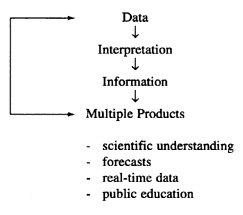
Figure 6.1
The USGS roles in hydrologic hazards.
tiple users and multiple products. Examples of products and users of this information include the following:
- Federal, state, and local emergency management agencies (FEMA, National Weather Service). Such agencies require reliable real-time datasets and statistical distributions (current water levels, stream rating curves) for effective forecasting and analysis of the consequences of extreme events. Such users are most often interested in basic data with little or no interpretation or analysis.
- Federal, state, and local water resource management agencies (U.S. Army Corps of Engineers, U.S. Environmental Protection Agency, state and local environmental institutions), industries, and technical consulting firms. These institutions often require longer-term information about environmental conditions (lowflow duration curves, historical low-and high-water levels, water quality information) for use in developing and implementing environmental regulations and in the planning, design, and operation of water-related facilities. Often these clients require technical summaries and interpretations of data rather than the actual raw data.
- General public, private citizens, educators, law enforcement officials, the news media, nonprofit environmental groups, private insurers, etc. These parties rely on the USGS to provide not only raw data but also interpretation and explanation of the meaning of the data, which then becomes the basis for planning, investment, and management of programs related to hydrologic hazards. These users often require explanations of the basic principles of hydrology, probability, and flood/drought consequences. What is needed are ways to help decision makers and citizens better visualize probabilities and consequences of hazards within the context of their particular situations.
- The scientific community. The larger scientific community interested in hydrologic processes requires the data, interpretations, and models developed by USGS scientists to advance the state of the science and develop a better understanding of the physical causes and consequences of extreme hydrologic events. USGS scientists should continue to publish scientific reports and participate in scientific conferences to share findings with their colleagues.
Floods and Droughts
Role of the USGS
Through its national streamflow measurement program, the USGS should continue to be the nation's primary supplier of reliable streamflow and water-level data. This information will continue to be used by the National Weather Service and other agencies for flood forecasting, design purposes, and for forecasting low flows and water levels in times of drought.
The committee believes the USGS has an additional important role in the measurement, documentation, and analysis of extreme hydrologic events, both during and after they occur. The USGS is ideally positioned to collect and archive the critical hydrologic information necessary to improve our understanding of how and why such extreme events happen and to improve our ability to predict these events. In particular, the USGS should initiate process studies on high-magnitude, low-frequency events (both floods and droughts) to improve our overall technical understanding of how and why these events occur.
Recommendations
USGS flood and drought science should focus on the following areas:
- Maintaining the integrity and continuity of the national stream gaging network. The USGS stream gaging network is a unique and irreplaceable source of primary data supporting planning, research, and management for hydrologic hazards. It is of critical national importance that this source of consistent and reliable hydrologic data be maintained, both as the foundation for other hydrologic activity conducted by USGS and as the basis for planning and operations carried out by countless other public and private entities.
- Improved stream gaging network design, measurement techniques, and instrumentation for the measurement of streamflow and stream stage. Obtaining streamflow data, particularly if the current climate of funding cutbacks continues, will require new and innovative instrumentation and monitoring techniques. Recent advances in microprocessors, electronics, and satellite communication are leading to a new generation of reliable, precise, and relatively inexpensive field
- instrumentation equipment. Research in gaging network optimization will help obtain the best information for a given level of investment.
- Postaudits of technical response and prediction of major floods. Postaudits of major floods such as the 1997 Red River flood in North Dakota should be conducted, with the goal of improving data collection, flood forecasting, and risk communication. If there were problems with the flood forecasts, why did they occur and how could they have been avoided? Were appropriate data collected before, during, and after the flood to improve our understanding of the causes and effects of the flood?
- Improved discharge measurements of extreme floods. Currently used methods of flood forecasting usually employ the traditional stage-discharge relations developed at stream gages. The stage-discharge relationship often breaks down during extreme events that are beyond the range of normally measured stages. Techniques such as acoustic doppler profiling or process modeling may allow rating curves to be extended beyond their traditional limits.
- Improved approaches for regional flood-frequency estimation. Opportunities to improve Bulletin 17-B (USIACWD, 1982), better estimation of flood-frequency relations in ungaged watersheds, and better ways to incorporate historical and paleoflood data into flood-frequency analyses need to be pursued.
- Improved methods for drought forecasting. Emphasis should be placed in integrative studies linking climate variability, terrestrial hydrology and surface-ground water interactions at the regional scale.
- Investigations of long-term stationarity of floods and droughts. Current frequency estimation methods usually assume that flood peak heights, discharges, and recurrence intervals follow statistical distributions that do not change with time. This assumption of stationarity is not consistent with the natural variability exhibited by hydrologic data when long records are available. How are flood heights responding to short-term and long-term changes in land use, urbanization, weather patterns, and water management regimes? What is a reasonable period of record with which to evaluate flood risks? Such investigations could also consider prehistoric information such as that offered by tree ring data and paleo lake studies to estimate the magnitude and frequency of very rare flows.
- Improved techniques for low-flow frequency analysis, and its relevance to instream flow management and ecologically based regulatory criteria . Low-flow frequency analysis, commonly draws on flood-frequency techniques developed to estimate long-term averaged exceedance probabilities or drought risks. The Water Resources Division and the Biological Resources Division should collaborate to improve our understanding of the relationships between simple quantile estimates of low-flow frequencies and the response and sensitivity of aquatic ecosystems to the magnitude, duration, and interarrival times of low-flow regimes.
Assistance in Risk-Based Decision Making
Role of the USGS
As the nation's principal provider of geologic and hydrologic data, the USGS should position itself as a respected national resource for information needed for risk-based decision making with respect to hydrologic hazards. To be such a resource, the agency will need to continue to maintain a staff of respected unbiased scientists working in the hydrologic hazards area. In addition, the agency will need to support integrated database management systems to inventory, store, and make accessible regularly collected meteorological and hydrologic information, on a watershed-by-watershed basis, with easy linkages between weather, topographic, streamflow, and reservoir management data, probably through the use of geographic information systems (GISs). This information should be readily accessible to researchers involved in the development and testing of statistical and deterministic models for hydrologic processes.
Recommendations
- The USGS should conduct research on techniques for estimating the probability and magnitude of extreme hydrologic events in the context of risk-based decision making.
- The USGS should evaluate how long-term cumulative impacts of land use, river regulation, or climate change can affect and contribute to hydrologic hazards.
- The USGS should work to improve integrated risk and process models related to floods and droughts.
Water Resources Data
Role of the USGS
The USGS has long and broad experience in collecting, managing, and disseminating water resources data. These data functions continue to be a critical part of the hydrologic hazards program and must be maintained. The recent integration of the Biological Resources Division into the USGS provides a new opportunity to improve the integration of water resources data with biological and ecological data.
Recommendations
- The USGS should place new emphasis on rapid data acquisition and retrieval during extreme events. Real-time dissemination of provisional data acquired during floods will permit better decision making.
- The USGS should explore methods for integrating datasets over several scientific disciplines. Understanding hydrologic hazards usually requires data from several different scientific areas. For example, landslide forecasting might require information collected by hydrologists, geologists, engineers, soil scientists, and climatologists. Historically, such data have been stored in different formats by different agencies. GIS technology may offer techniques for integrating, analyzing, and displaying such dissimilar datasets for improved analysis of hydrologic hazards.
Public Outreach and Hazards Communication
Role of the USGS
The ultimate goal of the hydrologic hazards program is to assist in protecting the lives and property of citizens from naturally occurring hazards while maintaining and protecting ecological communities. This requires that hazards information and research results be communicated to the public, and to public officials, in a timely and understandable manner. The translation of research science to public understanding and public policy is often difficult and usually requires special skills. The revolution in information technologies has stimulated dramatic changes in how the USGS collects and disseminates its data and in the audiences interested in this information. In response, the emphasis of the USGS mission to provide the nation with reliable and impartial information to reduce loss of life and property and to preserve resources has shifted from a more passive role of study and analysis to one that actively seeks to convey information in a way that is responsive to the social, political, and economic needs of particular communities. It is critical that the USGS maintain and develop liaisons with outreach specialists in other federal agencies, federal and state extension programs, universities, state and local units of government, commercial organizations, and citizen interest groups. Individual USGS scientists should develop networks of public contacts and should be encouraged to participate in public discussions of hazards issues.
Recommendations
The USGS should continue to employ both new and existing technologies to enhance the communication of hazards information to multiple and diverse client groups. Examples of communications efforts include the following:
- Direct involvement of USGS scientists in communication with the public.
- Development of hazards maps for various parts of the United States. The format, scale, locations, and types of hazards shown on such maps may vary from place to place.
- Integration of hazards maps with electronic databases and GISs. Examples from the Cascades Volcano Observatory and Louisiana HydroWatch program illustrate the utility of hazard mapping oriented for the public. These outreach products represent an intelligent match for the mapping, data collection, and analytical strengths of the USGS. The agency should expand this effort into several other areas. What is the best way to communicate hazards information from agency to agency? How can hazards information best be integrated and utilized in public policy decision making? The USGS mission in outreach should not be to direct particular decisions about hydrologic hazard management. Instead, the agency should ensure that decisions are made with the best possible understanding of probabilities and magnitudes of adverse consequences. To put it another way, outreach should help decision makers avoid being "surprised."
- The USGS is progressive in its use of the Internet for the presentation of real-time and historical data. These programs are impressive, and the agency should continue to expand these efforts as well as add interpretations to its hydrologic data. In addition to the Internet, real-time data need to be disseminated along other available avenues.
- There is a critical need for improved methods of risk communication. Since most people do not understand the simple concepts of probability (e.g., 100-year floodplain), it would be highly useful to explain flood risk in terms of possible or probable consequences by creating various scenarios. These scenarios might then be very effectively illustrated by graphical computer simulations or animations. What is needed are ways to help decision makers better visualize the probabilities and consequences of hydrologic hazards. The USGS can take the lead in improving this understanding by developing effective "visualization" approaches.


