
6
Soil Moisture
INTRODUCTION
The existence, quantity, and nature of all life forms on our planet are closely linked to the distribution and phase of water in Earth 's biosphere. Soil moisture is a fundamental parameter of the terrestrial environment; its spatial distribution and temporal variation are crucial ingredients of hydrologic, ecologic, and climatic models, on regional and global scales. It is estimated that only 4 percent of Earth's water is stored terrestrially. Of this, approximately 25 percent is subsurface water and the remainder is stored primarily in the solid phase as snow and ice. Though of relatively small total quantity, water in the terrestrial regime plays an active role in the global hydrologic cycle and is estimated to contribute 21 percent of global precipitation and 14 percent of global evapotranspiration.
The horizontal and vertical distributions of soil moisture exert control over the partitioning of incoming radiant energy into latent and sensible heat fluxes via evaporation and transpiration by plants. Soil moisture also affects soil albedo. Near-surface soil-moisture distribution helps to determine the fate of precipitation as surface runoff or as percolation down into the soil column. The timing and magnitudes of these horizontal and vertical transports of liquid water are important determinants in the geochemical cycling of nutrients, the availability of soil water for plant growth, the recharge of aquifers and reservoirs, and soil engineering properties. Excessive percolation can lead to leaching of soil nutrients, as is common in the humid tropics. Excessive runoff can lead to catastrophic flooding. The recent flooding and landslides in Central America caused by hurricane Mitch may have been exacerbated by antecedent drought conditions related to El Niño/Southern Oscillation (ENSO).
Soil-moisture information is also useful for commercial applications associated with farming practices and irrigation. The annual growth rate of world agricultural production has slowed from about 3 percent in the 1960s to less than 2 percent (FAO, 1995). This trend is expected to continue as more marginal lands are brought into production. Productivity is generally limited by either nutrient or moisture availability. Much of the focus of the green revolution was on optimizing nutrient availability, with increased use of irrigation to redress moisture deficiencies. Currently 19 countries are listed as “water scarce, ” with less than 100 cubic meters of fresh water available per capita, and the number is expected to increase to more than 46 countries over the next 30 years (NOAA, 1997). This trend, based on population growth, will be compounded by increasing agricultural demands for water due to continued agricultural expansion into semiarid and arid regions dependent on irrigation. The
status and availability of soil moisture are expected to be of increasing geopolitical significance in such regions as the Middle East and sub-Saharan Africa.
Despite its unquestioned significance and recognition by science working groups that it is among the most important environmental parameters that NASA's suite of sensing satellites should monitor on a global scale, no means are available today to map soil moisture on any scale, nor are there any specific plans to do so in the near future. Soil moisture has not been widely applied as a variable in any land process models for two primary reasons. It is a difficult variable to measure on a consistent and spatially comprehensive basis. It also exhibits great spatial and temporal variability; hence point measurements have little meaning. Consequently, soil moisture has not been used as a measurable variable in current hydrologic, climatic, agricultural, or biogeochemical models due to a lack of appropriate data. Although soil moisture is listed by NOAA as a critical climate environmental data record (EDR) (NOAA, 1997), it is the only EDR for which no threshold and objective values are provided. The committee 's assessment of the current status and future NPOESS plans for observing and measuring soil moisture from space is discussed in Box 6.1.
BASIC SCIENCE ISSUES
Because of its ubiquity, there are numerous potential science applications for frequent and spatially comprehensive measurements of soil moisture. Most of these fit under the following four science issues:
-
Understanding the role of surface soil in the partitioning of incoming radiant energy into latent and sensible heat fluxes at a variety of scales, from the mesoscale to general circulation model (GCM) scale;
-
Understanding the relationship between the moisture in the top 5 cm of soil that is observable by microwave techniques and the total profile (1 m or more) of soil moisture that is accessible to plants and is available for transpiration to the atmosphere;
-
Understanding how spatial and temporal patterns of soil moisture are related to the physical and hydrological properties of soils; and
-
Understanding how the spatial and temporal patterns of soil moisture can be used to improve our ability to model runoff at a variety of scales and adapt hydrologic models to areas of differing climate, biomes and soils, and geology.
With a potential for measuring soil moisture demonstrated, how might society use such soil moisture measurements? As in the science issues, there are four general areas in which routine measurements of soil moisture could have major impacts on day-to-day life:
-
Improving medium-range weather forecasting by incorporating measured soil moisture on a 30-km grid daily;
-
Improving on-farm irrigation scheduling and efficiency, and improving crop yield modeling for domestic and foreign areas, among other agricultural applications, at scales of 10 m to 100 m and 1 to 3 days.
-
Better quantifying water use, storage, and runoff to monitor existing resources and to assist decision makers in allocating limited resources or coordinating relief efforts in times of flooding, at scales of 100 m to 1 km and daily or on demand.
-
Improving climate models, particularly for annual and interannual variability, so that they represent the land surface hydrologic processes accurately. Measured soil moisture can be used as a state variable and as a validity measure for GCMs. The scales of interest are 1 to 10 km, possibly averaged to coarser resolution, at time scales of 1 to 7 days.
Status of Soil Moisture Sensing
The status of soil-moisture sensing may change somewhat after the European Space Agency (ESA) launches ENVISAT in June 2001 and the National Space Development Agency (NASDA) of Japan launches PALSAR in
|
Box 6.1 Findings Soil moisture would be a valuable input to the current hydrologic, climatic, agricultural, and biogeochemical models if it could be reliably measured at the appropriate spatial scales and over time intervals relevant to the processes of interest. A brief summary of the importance of soil moisture is given below, modified from Evans et al. (1995). An important role of the land surface component in general circulation models (GCMs) is to partition incoming radiative energy into sensible and latent heat fluxes. Soil moisture is known to be the major determining factor. A number of modeling studies have demonstrated the sensitivity of soil moisture anomalies to climate (Walker and Rowntree, 1977; Rind, 1982; Shukla and Mintz, 1982; Delworth and Manabe, 1988). Soil moisture is found to be an important forcing function, second only to sea surface temperature at mid-latitudes, and it becomes the most important forcing function in the summer months. The role of soil moisture is equally important on smaller scales. Recent studies with mesoscale atmospheric models have demonstrated sensitivity of circulation and precipitation to spatial gradients of soil moisture. Fast and McCorcle (1991) have shown that soil moisture gradients can generate thermally induced circulation similar to sea breezes. Chang and Wetzel (1991) concluded that the spatial variations of vegetation and soil moisture affect surface baroclinic structures through differential heating, which in turn indicate the location and intensity of surface dynamic and thermodynamic discontinuities necessary to the development of severe storms. In yet another study, Lanicci et al. (1987) showed that dry soil conditions over northern Mexico and variable soil moisture conditions over the southern Great Plains dynamically interacted to alter prestorm conditions and subsequent convective rainfall patterns. It is still unclear whether the spatial distribution of soil moisture collected at regional scales is useful for GCM and mesoscale modeling. One positive indicator is the recent study by Betts et al. (1994) during the summer of 1993 in the U.S. Great Plains region, showing that the use of current soil moisture measurements to initialize a forecast model can lead to improved rainfall predictions. Extreme wetness, in comparison with climatological average soil moisture, clearly was a factor in the effect. For more normal conditions, soil moisture anomalies will vary with the spatial and temporal scales of rain events—scales that may be meaningful to four-dimensional data assimilations and mesoscale modeling. Based on these studies and scales ranging from GCM to the mesoscale, it appears that soil moisture will be an important hydrologic variable for hydrometeorological modeling and validation studies. While the scientific needs are compelling and there are widespread applied needs that could be met, there is no existing satellite capability for measurement of soil moisture, nor are there any specific plans to develop such a sensor either for scientific research or to meet operational needs. The committee notes that microwave sensors (active and passive) have demonstrated a capability to provide near-surface soil moisture information under certain land-cover conditions and at certain spatial scales. There is a clear need for a study to make specific recommendations for such a capability. The committee urges that the study consider both research use and applied operational use, consider the appropriate range of spatial and temporal scales, consider calibration and validation of the sensor and derived information, and consider issues of integration with other operational and research programs. The committee considers it to be within the scope of NASA 's overall mission to move forward with such a program in collaboration with NOAA and USDA. |
2002. Each of these satellites is configured to carry dual-polarized synthetic aperture radar (SAR), which may allow the mapping of soil moisture for bare soil surfaces and for surfaces with short vegetation cover. To map soil moisture under a wide range of vegetation-cover conditions (but still limited to grasses and cultural vegetation), it is necessary to use a dual-frequency multipolarized SAR. NASA 's recently announced LightSAR, a comparatively small, inexpensive spaceborne SAR, may offer the requisite combination of wavelengths and polarizations for extracting soil moisture information from SAR images, for both bare and vegetation-covered terrain.
Among electromagnetic remote-sensing techniques, only active (radar) and passive (radiometry) microwave sensors have shown strong sensitivity to soil moisture content. Although the active and passive microwave approaches have often been regarded as competing or alternative options for sensing soil moisture, they are complementary in terms of what they offer. A dual-frequency, multipolarized SAR can generate high-to moderate-resolution (3 to 300 m) soil-moisture maps of nonforested terrain, whereas a low-frequency (L-band) microwave radiometer is particularly suited for mapping sparsely vegetated terrain at resolution scales in the range of 10 to 20 km.
The next three subsections discuss passive microwave remote sensing as a potential technique for mapping the distribution of soil moisture, active microwave remote sensing, and the complementarity of the two techniques. The three sections primarily address two questions:
-
How well can passive and active microwave sensors monitor soil moisture? and
-
What sensor configurations are needed to achieve it?
These discussions provide the background necessary for considering what soil-moisture estimation capability we might expect from satellite sensors planned for launch in the next few years.
Passive Microwave Sensing of Soil Moisture
Because microwave emission and backscatter by terrain are strongly influenced by vegetation cover, the committee first considers bare-soil surfaces and then vegetation-covered surfaces. For the purposes of this discussion, a soil surface is defined as bare if it is covered with less than 0.1 kg/m2 of vegetation. For a green field of grass, this biomass level corresponds to a height of about 10 cm. To maximize penetration through the vegetation cover as well as through the soil's top layer, the band of choice for sensing soil moisture is the L-band wavelength (21 to 23 cm), or longer if technologically feasible. At these wavelengths, a biomass level of 0.1 kg/m2 exercises negligible effects on the emission and backscatter from the underlying soil surface. Thus, the distinction between bare and vegetation-covered surfaces is made from the perspective of the microwave sensor, which is important because under the stated definition the bare-soil category encompasses a significantly larger fraction of Earth's surface than it would under a definition specifying totally barren.
Bare-Soil Surfaces
The emission from a bare-soil surface that would be observed by a microwave radiometer with its antenna beam pointed at the surface is governed by three main physical parameters: (1) the soil-surface temperature (Ts), (2) the volumetric moisture content of the near-surface layer (mv), and (3) the roughness of the air-soil interface, usually represented by the root mean square (rms) value of the surface height(s) (Choudhury et al., 1978; Jackson, 1993; Ulaby et al., 1986). Soil type, defined by texture and clay mineralogy, also exerts control over the microwave dielectric properties of moist soil (Hallikainen et al., 1985; Dobson et al., 1985). The effective depth of the emitting soil layer varies between 0.1 λ for wet soils and 1.0 λ for a dry-soil medium, where λ is the wavelength. In practice, the effective depth is considered to be 5 cm. After atmospheric corrections, measured values of the brightness temperature observed by the radiometer are converted into estimates of soil moisture after using infrared observations to estimate an effective surface temperature Ts and making corrections for the effects of roughness and soil type on the basis of auxiliary information about the terrain site under observation. Even with auxiliary information, however, it is difficult to estimate surface roughness, which renders the estimation process more or less heuristic. Fortunately, unless the surface is very rough, the error associated with the assignment of the estimated value of surface roughness leads to an acceptable level of error in terms of the estimated value of soil moisture.
Vegetation-Covered Surfaces
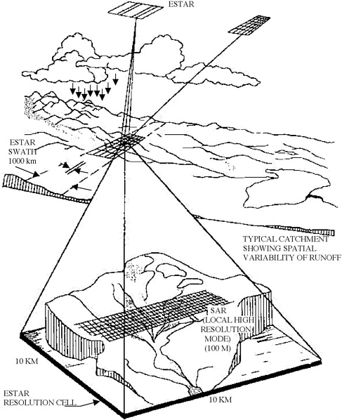
The presence of a vegetation layer above the soil surface alters emission in two ways: (1) it attenuates the energy emitted by the soil and (2) it adds an emission component of its own. Part of this component is emitted by the vegetation directly upward into the air; another part is initially emitted downward toward the soil surface and then, upon reflection by the surface, propagates upward through the vegetation layer into the air (Jackson and Schmugge, 1991). The vegetation layer introduces a masking effect, reducing the sensitivity of the microwave radiometer to soil moisture. The magnitude of the masking effect is dependent upon the structure and wet biomass of the vegetation layer. Both the attenuation and emission characteristics of the vegetation layer are wavelength-dependent; from a soil-moisture standpoint, it is desirable to choose as long a wavelength as possible. Because of other considerations, especially the fact that the angular resolution capability of a passive microwave instrument is governed by its antenna dimensions (measured in wavelengths), the consensus in the scientific community has been to designate the L-band as the optimum wavelength for passive microwave mapping of soil moisture. From a 600-km altitude, an L-band satellite-borne radiometer with a 15-m-diameter antenna (or an equivalent thinned-array configuration) would have an instantaneous field of view of about 10 km. When made to scan in a conical configuration at an approximately constant incidence angle of 45°, such a system can cover a swath width on the order of 1,000 km.
Passive Microwave Feasibility Demonstration
Over a period of 4 years, a team of researchers from the U.S. Department of Agriculture, NASA/Goddard Space Flight Center (GSFC), and the University of Massachusetts conducted several related investigations aimed at demonstrating two specific capabilities: (1) that it is possible to build and use a thinned-array antenna configuration for radiometric observations, thereby reducing the weight of the radiometer instrument by about a factor of 5, and (2) that it is possible to use an L-band radiometer for mapping soil moisture “over a range of cover conditions and within reasonable error bounds” (Jackson and LeVine, 1996). The first objective led to the development of an aircraft-mounted system called the Electronically Scanned Thinned Array Radiometer, or ESTAR. After its operational capabilities were demonstrated by comparing its performance to that of a traditional push-broom scanning instrument (Jackson et al., 1993; LeVine et al., 1990), ESTAR was used to achieve the second objective over a test site in Oklahoma known as the Washita site.
The results of the study are summarized in Figure 6.1 and Figure 6.2. The ESTAR instrument was flown over the test site on each of 8 days between June 10 and June 18, 1992. Each brightness temperature image was processed through an algorithm that attempts to correct for surface roughness and vegetation cover (estimated from SPOT data) to generate a soil-moisture image. The eight images displayed in Figure 6.1 followed a period of heavy rains over several weeks that ended on June 9, one day prior to the first ESTAR overflight. Thus, the soil was mostly saturated on June 10. Over the next 10 days, no rainfall occurred, allowing the soil to dry down and the ESTAR observations to display the gradual change (Jackson et al., 1995).
Figure 6.2 contains plots of model-calculated values of soil moisture versus brightness temperature, as well as measured values for selected ground surfaces. Based on this study by Jackson and LeVine (1996), the estimated accuracy of the soil moisture content predicted by the ESTAR instrument is 3.5 percent for bare-soil fields and 5.7 percent for vegetation-covered fields.
Regardless of which imaging technique is used, a passive microwave sensor is expected to generate 1,000-km-wide maps of soil moisture at a resolution of about 10 km × 10 km and at an accuracy of 3 to 6 percent, over the soil moisture range between 5 and 30 percent. With such a swath width, revisit time would be on the order of 3 days. The accuracy, swath width, resolution, and revisit interval of the soil moisture information provided by such a sensor is compatible with data inputs needed for the implementation of hydrologic models of large basins in most environments.
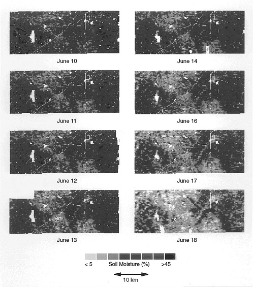
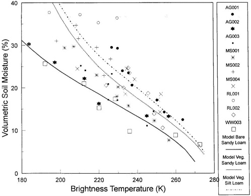
FIGURE 6.2 Ground verification of soil moisture estimation algorithm (Jackson and Le Vine, 1996).
Active Microwave Sensing
Bare-Soil Surfaces
The backscattering coefficient σ° measured by a radar system whose antenna beam is pointed at a bare-soil surface is governed by two physical parameters: the volumetric moisture content mv and the rms surface roughness s, and to a much lesser extent by soil type.
The functional dependence of σ° on moisture, as well as on roughness, is polarization-sensitive, meaning that the response of σ° to moisture and roughness varies for different combinations of transmit and receive antenna configurations. For a typical observational scenario (incidence angle and polarization), the dynamic range over which σ° varies in response to mv, varying from dry conditions to high wetness conditions, is comparable to the dynamic range over which σ° varies in response to surface roughness from smooth to very rough (for natural surfaces at L-band). Because σ° is equally sensitive to the soil moisture content mv and the surface roughness s, attempts by many researchers to use single-channel ERS-1/2 or JERS-1 SAR observations for estimating soil moisture have not met with much success. Conversely, observations by the Jet Propulsion Laboratory (JPL) airborne SAR (AirSAR) and by Shuttle Imaging Radar-C (SIR-C) have both shown that soil moisture can be retrieved with an accuracy of about 3.5 percent when two or more L-band polarization channels are used (Figure 6.3).
Implementation of a SAR soil-moisture inversion algorithm (Dubois et al., 1995; Oh et al., 1992; Ulaby et al., 1996) to SIR-C images of an area in Oklahoma led to the soil-moisture distribution maps shown in Figure 6.4. These figures correspond to relatively wet conditions (20 percent average) for the April 12, 1994, map and to relatively dry conditions (10 percent average) for the April 15 map.
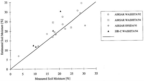
FIGURE 6.3 Comparison of radar-estimated soil-moisture values for bare-soil fields with in situ measurements. The synthetic aperture radar (SAR) observations were extracted from several AirSAR campaigns and from Shuttle Imaging Radar-C overpasses in April 1994 (Ulaby et al., 1996).
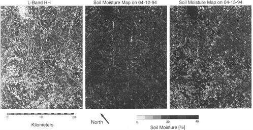
FIGURE 6.4 L-Band hh-polarized image and two soil-moisture maps derived from Shuttle Imaging Radar-C data for April 12 and 15, 1994. The first day was extremely wet, and the second day was drier (Ulaby et al., 1996).
The results of the SIR-C and other similar investigations, which are based only on L-band SAR observations, provide strong support for radar as a soil-moisture mapper. The bare-soil algorithms used in the generation of the soil-moisture maps ignore the presence of vegetation cover, which can lead to significant soil-moisture estimation errors for soil surfaces covered with vegetation whose biomass exceeds 0.5 kg/m2. For vegetation-covered soils, it is necessary to use two-frequency channels, as discussed below. An alternative approach, similar to that found to be useful in passive microwave radiometry of vegetated soils, would be to develop vegetation correction factors based on fusion with electro-optical data. Multispectral fusion approaches, designed to address this challenge, have not been seriously developed and tested.
Vegetation-Covered Surfaces
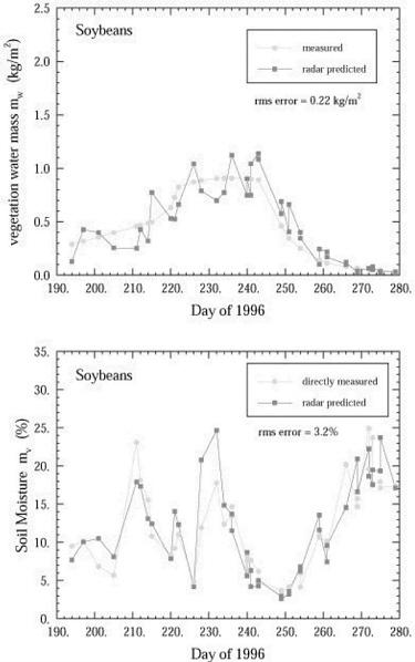
Using the combination of L- and C-band multipolarized SAR data, it is possible to classify terrain with an accuracy exceeding 95 percent for simple land-use/cover classes (Dobson et al., 1995; Pierce et al., 1994), which is on a par with the accuracy of ground-truth data. These land-use/cover classes include six basic types: (1) tall vegetation (trees), (2) short vegetation (cultural vegetation, grasses, rangeland), (3) urban areas, (4) bare surfaces, (5) water, and (6) flooded lands and swamps. The same SAR data are then applied to classify the short-vegetation pixels into a finer level, according to vegetation structure from a radar perspective. For each structural class, a soil-moisture algorithm can be applied to estimate both the soil-moisture content and the vegetation biomass. An example comparing SAR-predicted values of these quantities versus those measured in situ is given in Figure 6.5 for a soybean canopy (Ulaby, 1998).
Complementarity of Active and Passive Microwave Observations
Table 6.1 summarizes the sensor configurations appropriate for passive and active microwave techniques for mapping the distribution of soil moisture. To produce soil moisture maps with 10-km pixels from a satellite altitude of 600 km, a passive microwave radiometer would need an antenna 15 to 20 m in diameter or a rectangular aperture of comparable dimensions.
Two competing technologies have been proposed in the past 3 years, one involving an inflatable structure and the other using a thinned-array configuration. The objective of both designs is to develop a lightweight antenna with a large effective aperture. Each of the two aperture approaches offers some unique advantages; it is too early to make a clear-cut choice between them. The advantage of the inflatable antenna is that it can be made to scan in a conical format at an approximately constant incidence angle, thereby simplifying the soil-moisture inversion algorithm, but inflatable technology has not yet been tested for a 20-m-diameter antenna. The other approach, relying on the application of signal correlation to a large number of receivers, each connected to a linear antenna, ends up “thinning down” the aperture by a factor of about 5. Its proposed scan mode, however, is in the plane orthogonal to the direction of flight, encompassing a wide incidence angle range extending between nadir and 45°. Hence, a separate correction has to be applied to each beam position.
TABLE 6.1 Sensor Configurations for Mapping Soil Moisture with Active and Passive Microwave Techniques
|
Parameter |
Passive Microwave |
Active Microwave (SAR) |
|
Frequency band |
Bare soil: L-band |
Bare soil: L-banda |
|
Vegetation-ground: |
Vegetation covered: L + C |
|
|
L-band + NDVI correction |
||
|
Polarization(s) |
Horizontal |
Dual or polarimetric |
|
Antenna size |
20 m × 20 m |
10 m × 0.5 m |
|
Resolution from 600 km orbit |
10 km |
100 m |
|
Swath width |
1,000 km |
500 km |
|
aA longer wavelength, such as P-band, will also be suitable. |
||
To address the needs of applications requiring finer-resolution soil-moisture information, including small-basin hydrology, ecology, and agricultural concerns, a moderate-resolution (100 to 300 m) SAR can be used. When operated at such a moderate resolution, the SAR can generate images with swaths of about 500 km while maintaining the data rate at a level acceptable for transmission. A dual-polarized L-band (or longer wavelength) SAR can generate soil-moisture maps for bare-soil surfaces (which by the previous definition include surfaces with 10-cm or shorter vegetation covers) with good accuracy. To handle vegetation-covered surfaces, an additional frequency is needed, preferably the C-band. The active and passive soil-moisture microwave mappers do not have to operate from the same platform, but there are some decided advantages to operating them together (Figure 6.6).
OBSERVING STRATEGY OF CURRENT AND FUTURE SATELLITE SENSORS
Sensors Currently in Use
Of the passive microwave sensors currently flying aboard orbiting satellites, none operates at the L-band (1 = 21 cm) and none is suitable for soil-moisture mapping. In spite of this, some attempts have been made to use Special Sensor Microwave/Imager (SSMI) data that are weakly correlated to soil moisture. Currently, no L-band radiometer systems are on any approved list for development and flight on a future U.S. mission or as part of any other space program. NASA solicited recommendations for post-2002 missions to support the Earth Science Enterprise in 1998. Both the interdisciplinary panel and the disciplinary panel in atmospheric chemistry and hydrology strongly supported a soil moisture mission. The group gave a high priority to a recommendation for use of low-frequency microwave radiometry techniques as an exploratory mission.
The SAR picture is less bleak; Japan operates an L-band SAR and ESA operates a C-band SAR, as does Canada (but with different polarization). All three are single-polarization sensors incapable of mapping soil moisture reliably. ESA plans to fly a dual-polarized C-band configuration on ENVISAT, which can be used to map soil moisture of bare-soil surfaces, but under a moderately limited range of conditions because the C-band is more sensitive to vegetation cover. Also, under current plans, the Japanese space agency is considering launching a dual-polarized L-band SAR in 2001. Such a system will be suitable for mapping soil moisture of bare-soil surfaces.
Future Sensors
The most promising future sensor for demonstrating the mapping of soil moisture is LightSAR because it will provide the needed combination of bands (both L and C) and polarizations (all states) to generate maps of terrain classes, to classify vegetation by structural class, and to map soil moisture content. It is important to note, however, that because soil-moisture mapping was not one of the key objectives of the LightSAR design, it was configured to generate high-resolution images (1 to 30 m) with narrow swaths (20 to 50 km) rather than moderate-resolution images with wide swaths. It will be possible to demonstrate that LightSAR data can indeed be used for the generation of soil-moisture maps, but their limited swath width (and correspondingly long revisit interval) will make them useful in fewer applications.
CALIBRATION AND VALIDATION
The design and operation of any satellite system for measuring soil moisture should consider sensor calibration and product validation carefully. Calibration and validation must be an integral part of mission planning. Relative and absolute calibration must be monitored over the instrument's lifespan to enable time series analyses of derived fields. Metadata must be sufficient to permit reprocessing of archived data with improved algorithms as they become available. Validation of estimates is especially challenging because of the natural spatial variability of soil moisture. Soil moisture is often measured in situ to support agricultural research, and such measurements may be made weekly or monthly on a long-term basis. Common methods include gravimetric measurement, time domain reflectivity (TDR), and neutron probes, generally conducted at one location or over a sparse network of locations and at several depths. Usually the vertical profile is well defined, but spatial sampling is not sufficient to detect or characterize gradients in the horizontal dimension. A high degree of spatial variability in soil properties such as moisture and hydraulic conductivity has been observed experimentally (Hawley et al., 1982; Rogowski, 1972). Thus, coarse-resolution estimates derived from satellite observations cannot be readily validated using such data. Measurements of local variability of soil moisture within agricultural fields often show standard deviations of about 2 to 3 percent (Bell et al., 1980). Hence, the local uncertainty even of intensive point sampling is comparable to the demonstrated uncertainties of the remotely sensed estimates. Consequently, a network of validation sites will have to be instrumented with calibrated arrays to record both the time-variant mean soil moisture and higher statistical moments. External validation cannot be accomplished using sparse point samples because of the extreme spatial and temporal variability of soil moisture; a network of well-calibrated arrays is required. The network should be distributed over a variety of land-cover types. Vegetation attributes such as type, leaf area index, and biomass should be monitored as well, to calibrate and validate vegetation effects on soil-moisture retrieval algorithms.
EVOLUTION STRATEGY
Considering the importance of soil moisture to climate physics and to the fields of hydrology, ecology, and agriculture, the committee strongly recommends that NASA provide the resources necessary to develop and launch soil-moisture mapping systems in the near future. A development strategy should be defined in conjunction with other relevant agencies such as NOAA and the U.S. Department of Agriculture (USDA). NASA has initiated strategic planning for a soil-moisture mission as part of its post-2002 Earth Science Enterprise planning and within the NASA Hydrology Program. The strategy has to define specific measurement requirements for various scientific and operational objectives with respect to land-cover type and spatial and temporal scales. The relative priorities of requirements can guide the development of specific technological capabilities.
The effects of vegetation are central to the discussion of microwave techniques for estimating soil moisture. A misperception that radiometry is less sensitive than radar to vegetation effects is largely the consequence of very few experimental efforts using radiometry outside arid to semi-arid landscapes, where vegetation cover is scant. Experimental work conducted at Texas A&M and the University of Kansas in the 1970s using truck-mounted radiometer and scatterometer observations of agriculture crops showed similar reductions in sensitivity to soil moisture for both the active and passive microwave techniques. Recent theoretical treatment of the issue also confirms that the masking effects of vegetation are similar for radiometers and radar in most instances (Du et al., 2000). Beyond some threshold of plant biomass, both active and passive measurement techniques must rely on multispectral fusion to estimate the type and quantity of overlying vegetation and to correct for the effect on emission or scattering. These correction factors can be derived from fusion with electro-optical data or microwave data with wavelength less than approximately 5 cm.
Current space-based assets are inadequate for absolute measurement of soil moisture. The next generation of orbital multipolarized SAR now under construction, ESA's ENVISAT and NASDA's PALSAR, will be capable of mapping near-surface soil moisture where vegetation cover is less than approximately 1 kg/m2. Coarse-resolution measurement of soil moisture can be accomplished with an L-band radiometer for bare soils. Extending measurement capability to vegetated (but nonforested) conditions will require the development of a multifrequency SAR or further development of multispectral fusion techniques. The ultimate success of any space-based measurement capability will be determined through calibration and validation with in situ measurements. It is critical that an in situ soil-moisture measurement strategy be developed to complement the remote-sensing strategy.
Information on the spatial distribution and temporal variation of the near-surface soil moisture content is needed over a wide range of spatial scales, from 10 m for some agricultural applications to 10 km or more for certain climate models. Coarse-resolution (10 km), wide-swath (1,000 km) soil-moisture maps are best provided by a horizontally polarized L-band radiometer using either a large inflatable antenna or a thinned array configuration. Moderate-resolution (100 m to 1 km) soil-moisture data can be provided at a swath width of 500 km by a dual-frequency (L- and C-bands), dual-polarized SAR.
REFERENCES
Bell, K.R., B.J. Blanchard, T.J. Schmugge, and M.W. Witczak. 1980. Analysis of surface moisture variations within large-field sites. Water Resour. Res. 16(4): 776-781.
Betts, A.K., J.H. Ball, A.C. Baljaars, M.J. Miller, and P. Viterbo. 1994. Coupling between land surface, boundary layer parameterizations and rainfall on local and regional scales: Lessons from the wet summer of 1993. Fifth Conference on Global Change Studies, American Meteorological Society 74th Annual Meeting, Nashville, Tenn., Jan. 23-28.
Chang, J.T., and P.J. Wetzel. 1991. Effects of spatial variations of soil moisture and vegetation on the evolution of a prestorm environment: A numerical case study. Mon. Weather Rev. 119(6): 1368-1390.
Choudhury, B.J., T.J. Schmugge, R.W. Newton, and A. Change. 1978. Effect of surface roughness on microwave emission of soils. J. Geophys. Res. 84: 5699-5706.
Delworth, T.L., and S. Manabe. 1988. The influence of potential evaporation on the variabilities of the simulated soil wetness and climate. J. Climate 1: 523-547.
Dobson, M.C., F.T. Ulaby, M. Hallikainen, and M. El-Rayes. 1985. Microwave dielectric behavior of wet soil, Part II: Dielectric mixing models. IEEE Trans. Geosci. Remote Sensing. 23(1): 35-46.
Dobson, M.C., F.T. Ulaby, and L.E. Pierce. 1995. Land-cover classification and estimation of terrain attributes using synthetic aperture radar. Remote Sensing Environ. ISLSCP Special Issue. 51: 199-214.
Du, Y., F.T. Ulaby, and M.C. Dobson. 2000. Sensitivity to soil mositure by active and passive microwave sensors . IEEE Trans. Geosci. Remote Sensing, in press.
Dubois, P.C., J. van Zyl, and T. Engman. 1995. Measuring soil moisture with imaging radars. IEEE Trans. Geosci. Remote Sensing 33: 915-926.
Evans, D.L., J. Apel, R. Arvidson, R. Bindschadler, F. Carsey, J. Dozier, K. Jezek, E. Kasischke, F. Li, J. Melack, B. Minster, P. Mouginis-Mark, and J. van Zyl. 1995. Spaceborne Synthetic Aperture Radar: Current Status and Future Directions . NASA Technical Memorandum 4679.
Fast, J.D., and M.D. McCorcle. 1991. The effect of heterogeneous soil moisture on a summer baroclinic circulation in the central United States. Mon. Weather Rev. 199(9): 2140-2167.
Food and Agriculture Organization (FAO), United Nations. 1995. World Agriculture: Towards 2010. An FAO Study. Nikos Alexandratos (ed.). New York: John Wiley & Sons.
Hallikainen, M., F.T. Ulaby, M.C. Dobson, M. El-Rayes, and L.K. Wu. 1985. Microwave dielectric behavior of wet soil, part I: Empirical models and experimental observations. IEEE Trans. Geosci. Remote Sensing. 23(1): 25-34.
Hawley, M.E., R.H. McCuen, and T.J. Jackson. 1982. Volume-accuracy relationship in soil moisture sampling. J. Irrig. Drain. Div. Am. Soc. Civ. Eng. 108(IR1): IR1-IR11.
Jackson, T.J. 1993. Measuring surface soil moisture using passive microwave remote sensing . Hydrol. Processes 7: 139-152.
Jackson, T.J., and D.E. Le Vine. 1996. Mapping surface soil moisture using an aircraft-based passive microwave instrument: algorithm and example. J. Hydrol. 184: 85-99.
Jackson, T.J., and T.J. Schmugge. 1991. Vegetation effects on the microwave emission of soils. Remote Sensing Environ. 36: 203-212.
Jackson, T.J., D.M. Le Vine, A.J. Griffis, D.C. Goodrich, T.J. Schmugge, C.T. Swift, and P.E. O'Neill. 1993. Soil moisture and rainfall estimation over a semiarid environment with the ESTAR microwave radiometer. IEEE Trans. Geosci. Remote Sensing 31: 836-841.
Jackson, T.J., D.M.Le Vine, C.T. Swift, T.J. Schmugge, and F.B. Schiebe. 1995. Large scale mapping of soil moisture using the ESTAR passive microwave radiometer in Washita '92. Remote Sensing Environ. 53: 27-37.
National Oceanic and Atmospheric Administration (NOAA). 1997. Climate Measurement Requirements for the National Polar-orbiting Operational Environmental Satellite System (NPOESS), Workshop Report, Herbert Jacobowitz (ed.), Office of Research Applications, NESDIS-NOAA, February. 77 pp.
Lanicci, J.M., T.N. Carlson, and T.T. Warner. 1987. Sensitivity of the Great Plains severe-storm environment to soil moisture distribution. Mon. Weather Rev. 115(11): 2660-2673.
Le Vine, D.M., M. Kao, A.B. Tanner, C.T. Swift, and A. Griffis. 1990. Initial results in the development of a synthetic aperture microwave radiometer. IEEE Trans. Geosci. Remote Sensing 28: 614-619.
National Oceanic and Atmospheric Administration (NOAA). 1997. Weather and Climate Observing Systems: An Investment for America in the 21st Century. Boulder, Colo.: University Center for Atmospheric Research.
Oh, Y., K. Sarabandi, and F.T. Ulaby. 1992. An empirical model and an inversion technique for radar scattering from bare soil surfaces. IEEE Trans. Geosci. Remote Sensing 30: 370-382.
Pierce, L.E., F.T. Ulaby, K. Sarabandi, and M.C. Dobson. 1994. Knowledge-based classification of polarimetric SAR images. IEEE Trans. Geosci. Remote Sensing 32: 1081-1086.
Rind, D. 1982. The influence of ground moisture conditions in North America on summer climate as modeled in the GISS GCN. Mon. Weather Rev. 110(5): 1487-1494.
Rogowski, A.S. 1972. Watershed physics: soil variability criteria. Water Resour. Res. 8(4): 1015-1023.
Shukla, J., and Y. Mintz. 1982. The influence of land-surface evapotranspiration on Earth's climate. Science 215: 1498-1501.
Ulaby, F.T. 1998. SAR algorithm for mapping soil moisture and vegetation biomass. Soil Hydrology Meeting, Baltimore, Md., March.
Ulaby, F.T., R.K. Moore, and A.K. Fung. 1986. Microwave Remote Sensing: Active and Passive. Vol. III. Dedham, Mass.: Artech House.
Ulaby, F.T., P.C. Dubois, and J. van Zyl. 1996. Radar mapping of surface soil moisture. J. Hydrol. 184: 57-84.
Walker, J.M., and P.R. Rowntree. 1977. The effect of soil moisture on circulation and rainfall in a tropical model. Q.J.R. Meteorol. Soc. 103: 29-46.


