
3
The Impact of Weather and Climate on Society and a Vision for the Future
This chapter discusses ways in which society is becoming increasingly sensitive to weather and climate. At the same time, better understanding, observations, and numerical models are leading to improvements in the accuracy of weather and climate information. Together, the increased sensitivity and the availability of more accurate information are creating more and new users of environmental information and are heightening the value of this information. Satellites provide an essential component of a global observing system that serves as a foundation for an Earth Information System, a comprehensive environmental database that will support a large variety of users for the benefit of society. The trends highlighted above call for a more rapid transitioning of NASA research to NOAA operations in order to increase the rate of return to society from the public investment in research.
THE IMPACT OF WEATHER AND CLIMATE ON SOCIETY
There is widespread appreciation for the fact that the value of weather, climate, and environmental data, information, and forecasts is growing in importance to the U.S. economy (e.g., Colgan and Weiher, 2003). According to some estimates, up to 40 percent of the approximately $10 trillion U.S. economy is affected by weather and climate events annually (NRC, 1998a; NOAA, 2001b; Dutton, 2002). The cost of U.S. disasters related to weather and climate is rising rapidly, a consequence of population growth, rising wealth, and social behavior (Changnon, 2000; Pielke and Carbone, 2002). Approximately 90 percent of all presidentially declared disasters in
the United States are weather-related (Kelly, 2001). Weather affects aviation, air quality, health, ground and marine transportation, defense, agriculture, fisheries, water, energy, construction, tourism, and many other sectors of the economy. Even “good” weather can cause problems in this complex society; for example, one unexpectedly warm winter day in the Northeast can cost utility companies millions of dollars a day in unused energy.
There is also a growing awareness of the impact of climate variability and change, on time scales ranging from months to decades (NRC, 2001a). Shifts in rainfall patterns associated with climatic variability, such as those accompanying El Niño and La Niña, result in a nation and a world that is often plagued by drought and floods at the same time. Demand for climate data, information, and forecasts is growing rapidly, with NOAA’s National Climate Data Center (NCDC) receiving nearly 2 million online contacts from users in the year 2000, 77 percent from industry.1
As society becomes more sensitive to weather, the importance of weather prediction for the protection of lives and property and continued economic growth increases. For example, the U.S. population that resides within 50 miles of the nation’s coastlines and is most threatened by hurricanes and flooding is growing rapidly. Such population growth in these and other high-risk areas significantly increases the need for improved weather predictions and warnings to minimize risks to life and property. Another consideration is that the new economic concept of “just-in-time manufacturing” uses computer-timed and -directed supply systems to eliminate the warehousing of parts and products at ports and factories. However, even minor weather disruptions of land, sea, and air-supply-system pathways caused by snow, ice, and high-wind weather systems can now have large, leveraged impacts on these production systems, whereas previously they had little effect.
IMPROVEMENTS IN WEATHER INFORMATION PRODUCTS
The last several decades have seen major advances in the scientific understanding of weather and climate, and these advances, enabled by observational and computer technologies, have led to major improvements in warnings of severe weather, in short- and medium-range weather forecasts, and in climate outlooks on time scales ranging from a month to a year or longer. For example, the warnings of flash floods, tornadoes, and severe thunderstorms by the National Weather Service (NWS) have been improving steadily over the past two decades (Figure 3.1).

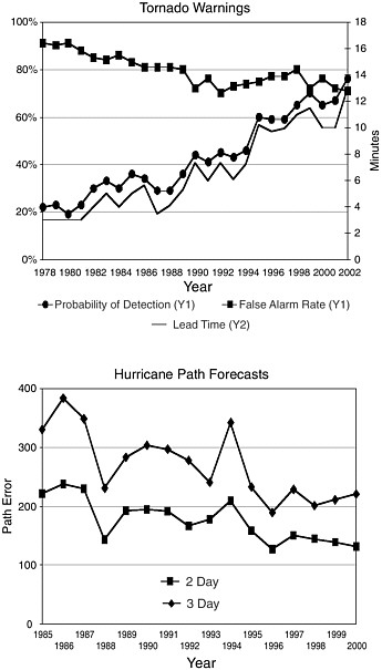
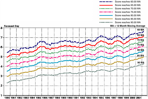
FIGURE 3.2 Trends in 500 hPa geopotential height anomaly correlations from 1980 to 2001 at the European Centre for Medium-Range Weather Forecasts (ECMWF). The graph shows the monthly moving average of the forecast day at which the forecast reaches a certain value of anomaly correlation (the correlation of observed and forecast anomalies) at the 500 hPa pressure level in the atmosphere (about 5.5 km or 18,000 ft). In 1980 it took a little over 2 days to reach an anomaly correlation of 0.90 (lower curve). By 2001 it took more than 4 days to reach this value; thus 4-day forecasts in 2001 were about as accurate as 2-day forecasts were in 1980. SOURCE: Anthony Hollingsworth, European Centre for Medium-Range Weather Forecasts, personal communication to Richard A. Anthes, November 2002.
NOAA’s statistics for the warnings show that the probability of detection and lead times are increasing while the false-alarm rate is decreasing. Errors in forecasts of hurricane paths have been decreasing. On longer time scales, 4-day forecasts today are as accurate as 2-day forecasts were 20 years ago (Figure 3.2).
Improvements such as these are leading to an increase in the value of weather and climate data for users, for example in the public sector and the various economic sectors mentioned above. They are also leading to significant savings in life and property. For example, since the discovery of wind shear associated with thunderstorm downdrafts and the implementation of the Low-Level Wind Shear Alert System
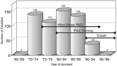
FIGURE 3.3 Number of fatalities associated with U.S. aviation wind-shear accidents from 1965 to 1999. Zero fatalities due to wind shear are reported in the 1965-1969 period because wind shear was not known to be a cause of aircraft accidents before 1970; thus, the actual number of aircraft accident fatalities due to wind shear before 1970 is unknown. Accidents did not begin to be documented until the number of jets flying became sufficiently large relative to this rare event. TDWR, Terminal Doppler Weather Radar. SOURCE: National Research Council (1983); updated by National Center for Atmospheric Research (NCAR) after 1983 (Richard Wagoner, NCAR, personal communication with Richard A. Anthes, August 2002). See <www.rap.ucar.edu/applications/llwas/index.html> for more information on the Low Level Wind Shear Alert System; accessed April, 2, 2003.
(LLWAS) and the Terminal Doppler Weather Radar (TDWR), to date there have been no aircraft accident fatalities due to wind shear after 1994 (Figure 3.3).
USERS OF WEATHER AND CLIMATE INFORMATION
New and improved weather and climate products are leading to new users, such as the “weather derivatives” industry (Dutton, 2002; Hertzfeld and Williamson, 2002; Colgan and Weiher, 2003). Weather derivatives are financial instruments that allow energy and other companies sensitive to weather and climate variability to spread out the risk associated with these uncertainties by purchasing “insurance” against such risks (Zeng, 2000; Rosenfeld, 2001). A multibillion-dollar industry that provides this protection against weather risks has emerged: it is an industry that is very sensitive not only to accurate weather forecasts but also to accurate historical climate data. It is notable that this weather- and climate-related industry was not foreseen before it suddenly emerged.
There have been many studies of the state of satellite remote sensing capabilities and of how progress can be used for greater benefit to society. Previous studies have
shown that present and future users will require access to data that are more detailed and available in less time. For example, business customers will use worldwide environmental information to plan operations in a global marketplace while at the same time requiring information with respect to specific times and locations (NRC, 2001b). New users will require access to environmental data and information within minutes, hours, or days of the recorded observations (NOAA, 2001c), depending on the type of application for the data.
Some applications for environmental data are still being defined (see Box 3.1). These include operational satellite oceanography and forecasts of solar ultraviolet radiation, air pollution, lightning, space weather, conditions leading to disease outbreaks, and water quality and availability (NOAA, 2001c; NRC 1999, 2000a).
The Department of Defense has been active in operational utilization of space-based products for decades. The legacy of DOD programs is founded on essential applications for intelligence, mission planning, and operations. New products are constantly sought and being developed. Remotely sensed environmental parameters have great potential for improving predictive capabilities (nowcast and forecast) of operationally important models. Imagery and derived parameters will provide highly resolved observational data in a near-real-time, quasi-synoptic manner where our national security forces need support. Some important information products will include highly resolved nearshore sea surface height, solar coronal emissions, ocean color, precipitable water, shallow water bathymetry, full wind profiles (including light and variable winds, which are critical for aircraft-carrier operations, especially in tropical areas), highly resolved aerosol characterizations, highly resolved ocean currents and waves, and sea surface salinity.
As weather and climate information increases in accuracy, users’ expectations and demands grow concurrently. Users want not only more accurate information, but also information that is higher-resolution (in both space and time). And they want the information packaged and displayed in ways that meet their specific needs and delivered in a timely fashion. While there is still significant room for improvement in the accuracy and quality of information and forecasts, there is also a great
|
BOX 3.1 Increased Emphasis on Satellite Observations for National Security With the now-constant threat of terrorism, there is increasing demand for accurate observations and forecasts of winds and atmospheric stability, which would control the transport of toxic gases and particles if they were released into the atmosphere at any location, at any time. This demand can be better supported by the continuous assimilation of higher-resolution and more accurate satellite data and other observations in advanced numerical models in a timely and efficient manner. |
deal of confidence that scientific and technological advancements provide an opportunity to satisfy the new and growing demands. A continually increasing demand for new and better data, high confidence in technological advances, and unpredictable market developments (such as the weather derivatives industry) combine to suggest that, in a nation as sensitive to weather and climate as the United States is, the value of future information and forecasts will increase, perhaps nonlinearly (NRC, 1999).
There is every indication that continuing advances will not only enable greater protection of life and property but will also result in greatly expanded opportunities to benefit economic activity, stimulate economic competitiveness, and improve environmental management (Pielke and Kimpel, 1997; NRC, 1999, 2000a; Dutton, 2002; Hertzfeld and Williamson, 2002; Colgan and Weiher, 2003). As summarized in the report From Research to Operations in Weather Satellites and Numerical Weather Prediction: Crossing the Valley of Death (NRC, 2000a, p. 17):
The potential is enormous. The demand for new and diverse forecasting products will continue to grow and, with implementation, these expanded products will promote increased human safety and stimulate economic benefits in the United States and elsewhere.
Given the great potential for increased societal benefits from improved weather and climate information, it is important not only to support the R&D required to realize the potential, but also to speed up the process by which research is transferred into operations. Serafin et al. (2002) suggest ways in which the weather service communities can remain abreast of the new opportunities and can implement those possibilities that are most promising. These suggestions include, for example, using expert systems in preparing forecasts, continuing the positions of science operation officers in National Weather Service field offices, and conducting joint research projects involving both research and operational communities. Key to an enhanced technology-infusion process is much more extensive interaction between the research and operational communities.
The two specific examples of progress cited above—providing a solution to the problem of wind-shear hazard to aircraft and making steady improvements in medium-range weather forecasts—have important lessons for accelerating the technology-infusion process. The wind-shear problem was solved by a focused effort involving researchers at universities, MIT Lincoln Laboratory, and the National Center for Atmospheric Research (NCAR), working closely with the Federal Aviation Administration (FAA). The spectrum of effort, ranging from basic to applied research to timely applications of the LLWAS and TDWR technologies at more than 100 airports around the country, was seamless—there were strong bridges across the valley of death in this example. The wind-shear problem was relatively easy to address because of the local nature of the phenomenon and the availability of
technologies to observe it in real time. Sustained governmental research support was assured because of the highly visible impact of the problem to society.
The other example of progress, the slow but steady increase in medium-range forecast skill, is quite different from the wind-shear problem. Medium-range forecasting is inherently global in nature and requires a wide variety of observing systems. It further requires many scientists to develop the observing systems, highly complex numerical models, and data-assimilation techniques. Rather than serving a limited specific customer, medium-range forecasting serves a very broad range of users. But, like the wind-shear problem, it also requires sustained governmental support for the research necessary to improve the operational forecasts, as well as focused and committed resources to carry out the transition to operations and the operations themselves.
THE UNPREDICTABLE NATURE OF THE VALUE OF NEW TECHNOLOGIES
As the goal of providing the Earth Information System is realized, many products, with both personal and commercial value, will be generated from the EIS’s comprehensive databases. The nature of many of these products is unpredictable (Box 3.2); they will emerge through the creative minds of entrepreneurs who sometimes may be only vaguely aware of the needs and the desires of end users. For example, Obermann and Williamson (2002, p. 3) point out: “Strange as it may seem today when satellite images are part of the daily news, the possible value of satellite data for U.S. weather forecasting was unclear before the dawn of the space age.”
User needs are not static. They evolve considerably as the state of the art advances around them and as new opportunities and capabilities present themselves. User needs are moderated by the ancillary conditions of availability, timeliness, reliability, and cost—all of which are constantly changing. The Global Positioning
|
BOX 3.2 The Unpredictable Nature of the Value of New Science and Technology “[D]espite considerable research on the topic, no accurate metrics exist that enable economists to determine both the quality and the future monetary value of economic benefits that may arise from the acquisition of new knowledge. Indeed, even the use of peer review and other methods of selecting future scientific missions cannot predict with accuracy the success of such scientific pursuits.”1 |
System (GPS) is a recent illustration of the enormous applicability and use of a technology that was neither foreseen nor part of most users’ set of requirements. The GPS provides precise latitude, longitude, and altitude data to receivers at any location on the planet. When these data, developed under the aegis of DOD, were released to the general public even before the GPS had become fully operational in 1995, it was done so without fees and with only minor degradation for security purposes. At the time, there were no extensive studies on what the utility or ultimate value of GPS to the public would be, although it was known that information about one’s precise location in real time would likely be of value to many users. What was not imagined, however, was that entrepreneurs would be able to take these data and integrate them into user-friendly, mounted, or handheld instruments in such an economical and compelling way that the research community and a huge portion of the public would suddenly become enthusiastic users. Nor was atmospheric sounding using the GPS as demonstrated in the Global Positioning System/Meteorology (GPS/MET) experiment (Ware et al., 1996) foreseen by the meteorological community. Thus, the availability of GPS data today serves a variety of interests, including those of the scientific community, commercial companies, a host of rescue and public safety organizations, and thousands of individuals who routinely employ GPS devices for recreational purposes. GPS has become a multibillion-dollar industry. It would not be unreasonable to extend this GPS exploitation scenario to the potential evolution of the utility of precise environmental information available to everyone on demand, all the time, anywhere on Earth.
In summary, it is often difficult to anticipate specifically the new ways in which the user community will employ enhanced environmental information, or even to estimate how the number of users may change as such information becomes available. But past experience, typified by the GPS example, indicates that new technologies and information will create new opportunities and applications that will be exploited by a variety of former and new users.
A VISION FOR THE FUTURE: TOWARD AN EARTH INFORMATION SYSTEM
Improved satellite observations and their more effective use in numerical models are essential because the satellite uniquely provides the global perspective required for the Earth Information System.
Atmospheric weather and climate data are an important part of the overall characterization and understanding of the Earth system. Observations from other parts of the Earth system, including the oceans, freshwater, land surfaces, ice, biosphere, and space environment, are also growing in importance (NRC, 2003). A long-range vision, or goal, implicit in many plans and reports and in the missions of NASA and NOAA is to observe the
Earth system in order to support the scientific understanding of this complex planet and to make useful predictions of its components for the benefit of life on the planet. The vision is an Earth Information System (EIS)—a four-dimensional (three spatial dimensions and time—past, present, and future) gridded set of quantitative, geo-referenced digital data that describe the Earth system. The EIS would be widely distributed and evolutionary, much like the experience in the early days of the Internet and the World Wide Web. The EIS prototype that exists today will be continuously updated in the future with new observations and analyses and will include the atmosphere, biosphere, hydrosphere, and lithosphere. As the EIS is updated, it will become ever more valuable and will support a larger and broader range of users. As Colgan and Weiher (2003, p. 6) put it with respect to environmental information: “On both the supply and demand sides, information permeates the creation of economic wealth in an unprecedented way.”
One of the keys to providing better and more useful weather and climate information and forecasts is to advance the capability for observing the atmosphere, oceans, freshwater, ice, and land surfaces. Satellites, with their unique global view, will play a crucial though not exclusive role in realizing these advances. A new era is about to begin in remote sensing (see Chapter 4, “Opportunities in Satellite Remote Sensing to Realize the Vision”). An international system of polar-orbiting and geostationary satellites is expected to lead to dramatic improvements in weather and climate analysis and forecasting. New infrared remote atmospheric sounding systems, cloud-penetrating microwave radiometers, GPS radio occultation measurements, active spaceborne radar and light detection and ranging (lidar), as well as in situ and remote sensing observations from the ground, balloons, and aircraft, will create a sensor web around the globe for future Earth observations.
For this vision of the Earth Information System to become a reality and maximize the return on the satellite research investment, a much more efficient means of transitioning from satellite research experiments to operational systems is required.
Essential for realizing this vision is continuous assimilation of the high-resolution satellite data into advanced numerical prediction models of the atmosphere and oceans to enable complete diagnoses of their states at all times. Numerical models fill in the space and time gaps in the global observing system through spatial and temporal interpolations of the observations (Figure 3.4). The models also predict the future state through the numerical integration of the dynamical equations governing the changing state of the coupled atmosphere-ocean system. The future global numerical models are envisioned to have a spatial resolution of 1 kilometer or better in the horizontal dimension and about 100 meters in the vertical dimension
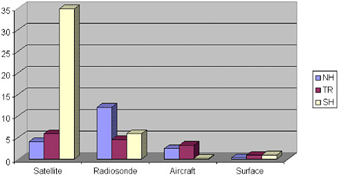
FIGURE 3.4 Example of the mean impact of various observing systems on U.K. Met Office global model forecasts. The results are obtained from an Observing System Experiment (OSE) using observations from July 2001 and January 2002. The figure shows the average (over 60 forecasts) change in root-mean-square (RMS) error of the 24-hr forecast (versus verifying rawinsondes) of 250-hPa vector wind when the observing systems listed are removed entirely from the global assimilation system. The vector RMS error has been averaged over three geographical areas: Northern Hemisphere (NH), 90°N–20°N; Tropics (TR), 20°N–20°S; and Southern Hemisphere (SH), 20°S–90°S. Results from the OSE indicate that satellite data (radiances and winds) have a particularly large impact in the Southern Hemisphere. A Met Office Technical Report describing the results in more detail is in preparation. Courtesy of United Kingdom Met Office.
(NRC, 1999).2 With the appropriate physics and data-assimilation procedures, the models will take advantage of the satellite observations specified with very high spatial resolution, producing both nowcasts and forecasts for a diverse user community.
Variations of the same numerical models will produce research-quality historical climate data sets through a continual “reanalysis” process. In this process, improved models will use data sets that are also improving through data cleaning or data curation. The resulting global, regional, and local climate data sets will have a
multitude of research and commercial uses. Wireless communications technology and handheld computer display terminals will enable anyone to receive these environmental products and predictions in real time, regardless of his or her geographical location, for immediate application and decision making.
For this vision of the EIS to become a reality and maximize the return on the satellite research investment, a much more efficient means of transitioning from satellite research experiments to operational systems is required.


