5
Technology to Enable Innovative Observations
“Beauty and grace are performed whether or not we will or sense them. The least we can do is try to be there.”
ANNIE DILLARD
Observations of many significant components of the polar regions remain extremely limited and nonstandardized, due to the small, scattered human populations, limited scientific infrastructure, and inherent difficulties of working in cold, remote environments year-round over sustained periods of time. Additionally, observation infrastructure and records are being lost, reduced, or eliminated in some countries, further restricting our ability to understand these complex regions. The International Polar Year (IPY) can make a major contribution to science and society by using the 24-month window during 2007-2008 to intensively observe and explore the polar regions at greater spatial and temporal resolutions, by undertaking international data rescue efforts, and by setting in place an observation network to enable ongoing observations of the polar regions in the decades to come. Innovative technologies will be instrumental for analyzing the myriad observations collected during the IPY and for disseminating IPY research to the broader public.
OBSERVING THE POLAR REGIONS DURING IPY 2007-2008
The efforts of the IPY 2007-2008 to assess the changing polar environments, explore new frontiers, implement interdisciplinary observatories, understand the human-environment dynamics, and build new connections between the public and the polar regions will require implementation of innovative technologies. In the temperate regions the past 50 years have brought the tools of science to a new level—measurement and observing technology, computing capacity, miniaturization, and a host of other advances. Measurements and techniques are possible now that were only seen in science fiction novels during the International Geophysical Year (IGY) in 1957-1958. The availability of innovative satellite data and
drilling techniques, as well as access to suborbital platforms and subsea vessels, will be vital for conducting intensive field studies during the IPY 2007-2008 and beyond.
Satellites first appeared as observational platforms during the IGY, and their initial instrument payloads immediately made major contributions to the success of IGY. Satellite-borne remote sensors of the Earth’s surface and space environment, as well as of the Sun, are continuing to evolve and become more sophisticated, and they will undoubtedly play an even more important role in the next IPY. Existing satellites obtain information across much of the electromagnetic spectrum and provide high spatial and temporal resolution data over the polar regions.
The rapidly approaching IPY precludes the inclusion of heretofore unplanned missions, but a number of planned U.S. missions with specific utility for the polar regions will be available in 2007-2008 (Table 5.1). The National Aeronautics and Space Administration’s (NASA) “A-Train” satellite formation consists of two major Earth Observing System (EOS) missions, three Earth System Science Pathfinder missions, and a French Centre National d’Etudes Spatiales mission flying in close proximity. This carefully planned formation of polar orbiting satellites allows for synergy, meaning that more information about the Earth and its polar regions is obtained from the combined observations than would be possible from the sum of the observations taken independently. All six satellites, Aqua, CloudSat, CALIPSO, PARASOL (French), Aura, and the Orbiting Carbon Observatory, will cross the equator within a few minutes of one another. Aqua was launched in 2002. There are a number of additional missions being developed by other nations or in partnership with the United States, and some, most notably Cryosat, have a specific polar mission. Coordination of satellite observations from this ever-growing international suite of sensors and additional focus by higher data rate sensors that do not collect data continuously would secure valuable benchmark datasets and advance the effort to assess the ongoing polar change.
Another IGY-era technology that has been advanced considerably since then is subsurface drilling, which provides information not accessible by satellite observation. Novel drilling technologies that could be adapted to do new science in the polar regions include directional drilling for retrieving ice cores and fast drilling for access of subglacial conditions. Directional drilling could retrieve ice core samples from locations at angles to the main vertical core and, at selected depths, generate multiple cores from a single surface platform. These additional samples allow for observations of the ways in which life forms have evolved and adapted to past climate and environmental change events. This technology forms the basis for new science of linked environmental and life system dynamics from ice cores. A fast-access mobile drilling system capability could be developed to rapidly drill arrays of boreholes through polar ice sheets 3 to 4 kilometers thick to allow targeted sampling from spatially distributed boreholes. Such a fast-access drill would enable a wide variety of research, from investigating conditions under ice sheets to borehole paleothermometry. Directional drilling and fast access drilling are employed in geophysical prospecting, but special design criteria need to be considered for drilling ice. There is also a need to develop drilling systems to be used for stratigraphic drilling to obtain paleoclimate records in the marine nearshore environment, from both fast sea ice and ice shelf platforms. Innovative technologies will allow continuous wireline coring, better core recovery, recovery of strata to a depth of 1,000 meters below the seafloor, and recovery of soft sediments. Other technologies must be developed for shallow water, such as shallow penetration drilling on polar continental shelves from ships.
TABLE 5.1 Some Future Satellites that May Be Useful During IPY 2007-2008
|
Satellite |
Mission Objective |
|
Aeronomy of Ice in the Mesosphere (AIM) |
Explore why polar mesospheric clouds, also called noctilucent clouds, form and why they are changing |
|
Aura |
Study the chemistry and dynamics of the Earth’s atmosphere by measuring ozone, aerosols, and several key atmospheric constituents that play an important role in atmospheric chemistry, air quality, and climate |
|
Cloud-Aerosol Lidar and Infrared Pathfinder Satellite Observations (CALIPSO) |
Provide new information about the effects of clouds and aerosols (airborne particles) on changes in the Earth’s climate |
|
CloudSAT |
“Slice” through clouds to see their vertical structure, providing vertical profiles of cloud liquid water and ice water contents and related cloud physical and radiative properties |
|
Landsat Data Continuity Mission (LDCM) |
Extend the Landsat record of multispectral, 30-meter resolution, seasonal, global coverage of the Earth’s land surface |
|
National Polar-orbiting Operational Environmental Satellite System (NPOESS) |
Monitor global environmental conditions related to weather, atmosphere, oceans, land, and near-space environment |
|
NPOESS Preparatory Project (NPP) |
Extend the measurement series being initiated with EOS Terra and Aqua prior to NPOESS |
|
Orbiting Carbon Observatory (OCO) |
Precise mapping of atmospheric carbon dioxide to enable more reliable forecasts of future changes in carbon dioxide and the possible effect on the Earth’s climate |
|
Solar-B |
Determine solar origins of space weather and global change and the mechanisms for solar variability |
|
Solar Dynamics Observatory (SDO) |
Study active region formation on the Sun from subsurface to corona and monitor solar irradiance |
|
Solar-Terrestrial Relations Observatory (STEREO) |
Trace the flow of energy and matter from the Sun to the Earth and provide unique alerts for Earth-directed solar ejections |
|
Space Technology 5 (ST5) |
Miniaturized satellites will map the intensity and direction of magnetic fields in the inner magnetosphere |
|
Time History of Events and Macroscale Interactions during Substorms (THEMIS) |
Investigate magnetospheric substorm instability, a dominant mechanism of transport and explosive release of solar wind energy |
|
Two Wide-angle Imaging Neutral-atom Spectrometers (TWINS) |
Three-dimensional visualization and resolution of large scale structures and dynamics within the magnetosphere to understand the global aspects of the terrestrial magnetosphere |
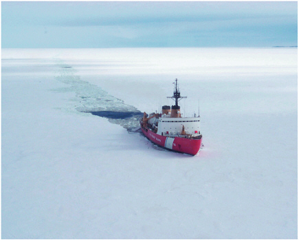
Sir Ernest Henry Shackleton’s ship, the Endurance, was crushed by ice in 1914, but that is unlikely to happen to today’s polar icebreakers, like the U.S. Coast Guard’s Polar Star, shown here. The Polar Star and her sister ship the Polar Sea are both 122 meters long. There are 154 crew members per ship and each ship can accommodate as many as 20 scientists. The Healy, the newest icebreaker, is specifically designed to conduct research activities, providing more than 4,200 square feet of scientific laboratory space, numerous electronic sensor systems, oceanographic winches, and accommodations for up to 50 scientists. These vessels have sufficient hull strength to absorb high-powered rams into the ice. The curved bow allows the ship to ride up on top of the ice, then the bow is levered through the ice like a giant sledgehammer. The Polar Star is able to ram her way through ice up to 21 feet (6.4 meters) thick and steam continuously through 6 feet (1.8 meters) of ice at 3.5 miles per hour (5.6 kilometers per hour/3 knots). SOURCE: U.S. Coast Guard.
Access to submarines, icebreakers, and long-range research aircraft has proven valuable in the past, and increased access to them for the IPY would provide important new data that are difficult to gather in other ways. For instance, use of instrumented submarines in the Scientific Ice Expeditions program during the 1990s provided new insights into the nature of the Gakkel Ridge. Instrumented submarines could provide new insights into linked physical-chemical-biological systems during the next IPY. The polar icebreakers, currently in a state of declining capability, are needed to provide an important platform for access to interdisciplinary observations. A research aircraft with long-range flight capability, possibly an instrumented C-130, would provide monitoring of coastal and interior Antarctica and of the Arctic with spatial and temporal resolution not possible from satellites.
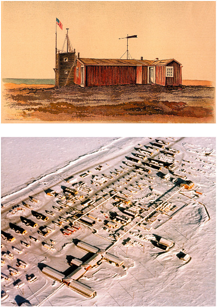
McMurdo Station (right) is the largest base in the Antarctic. The base can house some 1,000 people and support science of almost every discipline. Its modern laboratories and facilities are a far cry from Discovery Hut, November 4, 1911, on the left, built by the British explorer Robert Falcon Scott during his first Antarctic expedition. Scott later perished in a blizzard during his second expedition. SOURCES: Herbert Pointing. British Antarctic Expedition 1910-1913 (left) and George Somero, Stanford University (right).
Autonomous vehicles offer an entirely new tool for polar studies, and they can perform some functions that suborbital platforms, ships, and submarines cannot. For instance, there have been great advances in unmanned aerial vehicle (UAV) technology. The greatest benefits of using UAVs are that human lives are not endangered, they can fly in difficult weather conditions, they can remain aloft for long time periods (more than 24 hours), and they have tremendous range (Holland et al., 2001). Although still in their infancy, UAVs have been used in the polar regions to map sea ice conditions and atmospheric boundary layer conditions; the potential research applications are numerous, and their continued adaptation for polar operations would be greatly advanced by a concerted IPY research program.
Autonomous underwater vehicles (AUVs) are the subsurface complement to UAVs and share many of the same advantages—for example, long mission times and range with no risk to human life. AUVs have many applications for measurements under the floating ice shelves, the ice pack, and on missions in the open waters of the polar seas. They could be deployed for detailed exploration of subsurface features and for the study of hydrothermal systems and associated ecological systems. In addition, it would be possible for biologists to investigate questions of ecosystems and processes that, up to this point, have received little if any study. Another promising strategy for obtaining significant surface and near-surface observations is the deployment of instrumented robotic vehicles such as those in design and consideration for use on Mars. These vehicles travel slowly but are steadily powered by solar or wind energy and can accomplish a major traverse in a 100-day seasonal deployment. An international fleet of suitably designed rovers, each measuring useful variables relating to ice, snow, atmosphere, radiation, wildlife, chemistry, and so forth, hold extraordinary promise for collection of fundamental data across the most remote polar areas. In addition, the rovers could collaborate in such tasks as monitoring each other’s activities, aiding in calibration and maintenance, and the like.
ASSEMBLING LONG-TERM MULTIDISCIPLINARY POLAR OBSERVING SYSTEMS
A legacy of the IGY was the initialization of environmental monitoring records, such as the carbon dioxide record, which have proven key to documenting climate change and variability (NRC, 2004a). The intensive activity of the IPY 2007-2008 will extend measurements to include observations of linked physical, biological, and chemical observations of the atmosphere, oceans, ice, and land and will improve spatial and temporal coverage to provide a critical benchmark dataset for assessing the state of the polar environment. The infrastructure set in place will provide for long-term, spatially distributed, interdisciplinary observing networks to understand and explore the polar regions in the coming years and decades. The demand for observing systems that provide long-term measurements of important components of the Earth system comes from many fields. Climate change scientists (NRC, 2001b) recommend observing key state variables such as temperature, precipitation, humidity, pressure, clouds, sea ice and snow cover, sea level, sea surface temperature, carbon fluxes and soil moisture, and greenhouse gases. Oceanographers (NRC, 2004b) have recommended observing systems for key characteristics of deep-ocean features, including interdisciplinary measurements of physical, chemical, biological, and geological features. Biologists could utilize remote monitoring of organisms’ body temperature, heart rate, blood pressure, and oxygen. Although the polar regions play key roles in Earth systems, there is a paucity of continuous measurements, with extremely poor spatial resolution. Recently developed sensors, communications technologies, and the ever-decreasing size and power restrictions of sensors all hold promise for developing a more extensive Arctic and Antarctic observing network.
The development and installation of international, long-term, multidisciplinary observing networks could be a particularly significant legacy of the IPY 2007-2008. These observing systems would provide scientists and decision makers with real-time information on the evolving state of the polar regions for decades to come. Stations that remain relatively fixed in place, such as on land or on stable ice sheets, as well as stations moving with the ice and seas, can be developed to integrate physical, biological, and chemical measurements. Innovative technologies could be applied so that sensors can vary their observational parameters or temporal sampling rates and interact with each other in a “sensor web.” Sensors that can change the observation parameters or sampling rate when they sense unusual readings, such as a magnetic storm in Earth’s upper atmosphere, are particularly valuable for the polar regions given their remoteness and the fact that in situ measurements are difficult to obtain. Some leading-edge sensors are even self-activating; that is, they remain dormant until the phenomenon they are programmed to measure occurs. The polar environment is an ideal proving ground for advancing these concepts, with tangible benefits from improving the relative proportion of valuable data that are collected to the more efficient use of available power. The next IPY offers the opportunity to realize permanent gains in this area by bringing together an international set of ideas and creative engineering approaches.
Innovative technologies now allow the design of polar observing systems that are less constrained by size, power, and data handling requirements than were previous measurements. For instance, miniaturization has been a hallmark of scientific instrument development since at least the beginning of the twentieth century, and over the past 50 years each decade has seen reductions in instrument size. This facilitates
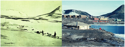
Science has had a role in Barrow, Alaska, since an observatory was built during the first IPY in 1882-1883. The Naval Arctic Research Laboratory (NARL) was established in 1947, and its facilities were turned over to the Barrow Arctic Science Consortium in 1980. SOURCES: 1884 War Department Report prepared by expedition leader, P.H. Ray. U.S. Army Signal Corp. and U.S. DOD Navy photo, Office of Naval Research and Former NARL. Photo organized by Leslie Nakashima (top) and John Kelley, University of Alaska-Fairbanks (bottom).
deployment on smaller, more agile platforms. Power systems, their capacities, their endurance, and their survivability under harsh polar conditions continue to be important constraints for polar science and logistics. This is a problem faced at all scales, from the significant power consumptions of large year-round stations to providing a stable supply of power to the smallest microsensors. There have been many recent advances in fuel cell, solar, radioisotope thermoelectric generators, and other technologies that can be marshaled for IPY 2007-2008 and adapted to the appropriate scale. As the efficiency and reliability of autonomous vehicles and stations increase, and until the communications bandwidth and availability also increase, the need for better data storage capabilities will continue to rise sharply. This poses challenges for engineers and computational scientists who must be engaged to work with polar researchers in resolving the design issues associated with increased data memory and storage capacity in polar environments.
Increased base infrastructure to support people doing research in the polar regions is needed to advance understanding and discovery. Remote systems require servicing and support, and collected data and samples need security and forwarding. Along with remote systems, human-intensive field operations require improved research base infrastructure and reliable logistical support. These needs are common to both polar regions. In the American Arctic, for example, the former Naval Arctic Research Laboratory facility outside Barrow has offered researchers space and logistical support from renovated but formerly derelict Quonset hut buildings that were constructed in the 1940s (Norton, 2001). The Barrow-area situation is being improved by construction of the 20-laboratory 50-bed Barrow Global Climate Change Research Facility. This is the first step in addressing modern support requirements of an increasingly expanding and interdisciplinary Arctic research program based on Alaska’s North Slope. The construction of sustainable research facilities at both polar regions must be coupled with significant data capture and transfer capacity and remote support capabilities in order to meet today’s and currently envisioned future research requirements.
Research bases are not the only infrastructure in need of upgrading. Icebreakers have fallen into disrepair; logistical support, including helicopters, is exceedingly scarce; submarine capability needs to be updated and resources allotted to the support of basic research falls at least an order of magnitude below that available elsewhere. Advances in aeronautics and navigation have steadily increased access and safety of flight operations in the polar regions, and some key Arctic stations now have year-round access by air. However, year-round access to most of Antarctica, excepting the Antarctic Peninsula, is not routine (winter flights mostly are for humanitarian reasons). Although winter flights to high-altitude Antarctic ice sheet stations continue to be risky, extending access to other regions may be feasible and would open new scientific opportunities even if flight operations were extended to encompass the nine weeks or so after sunrise and before sunset.1 The development of the Antarctic Mesoscale Prediction System provides the weather forecast tools to enable expanded flight operations anywhere in Antarctica.
Finally, enthusiasm to deploy innovative sensors and instruments must be balanced with potential environmental impacts. For many decades, scientists and engineers have
concerned themselves with the development of sterile instruments for the exploration of new environments such as the planets and their moons. The Antarctic Treaty and related conventions and protocols set rigorous environmental standards for science. Whenever probes are sent into previously unexplored environments in the polar regions, they may be deployed only after their environmental efficacy has been demonstrated. Environmental risks in the exploration of unexplored polar environment should not be taken until the efficacy of instrumentation is demonstrated. Using the impetus of the IPY 2007-2008 to develop sound, proven instrumentation may delay some observations, yet development during the IPY will provide a basis for exploration and observation in the decades to come.
INNOVATIVE DATA ANALYSIS TECHNOLOGY
The international cooperative research programs envisioned for the new IPY will produce large amounts of data that ultimately will need to be analyzed during and after 2007-2008. A few of the innovative types of data analysis likely to contribute to IPY science are highlighted here.
The rapid advances in computing technology since the IGY have provided scientists with tools to perform statistical analyses and develop dynamical models that were not previously possible. Statistical analyses can uncover spatial patterns and temporal trends in data, and they can be used to identify environmental relationships and test theoretical models (Zwiers and von Storch, 2004). The availability of powerful computers underlies new modeling efforts, and the IPY could advance U.S. effectiveness in climate modeling by applying the recommendations of a previous National Research Council report on improving climate modeling (NRC, 2001a).
Genomic and bioinformatic data analysis will play an important role in diverse types of biological research in the polar regions. The key roles that genomic techniques will play in polar biology were indicated in Chapter 4. However, data gathering is only the first step in exploiting the potentials of genomics. High-throughput DNA sequencing generates enormous datasets, which must be annotated and stored in readily accessible formats to ensure broad use (NRC, 2003a). Analysis of gene expression, using the techniques of proteomics (characterizing the suite of proteins present in a sample), likewise involves massive datasets and creates challenges for making the data easily interpretable and accessible to a broad range of users. Standardization of techniques for data gathering and analysis through bioinformatic methods will be necessary to allow the full potential of contemporary genomic science to contribute to polar biology.
Data assimilation focuses on the assessment, combination, and synthesis of observations from disparate sources to reproduce the evolution of a system and forecast its behavior. For instance, merging observations with short-term atmospheric forecast model output is a technique for optimizing the impact of the spatially sparse and temporally limited observations typically available in the polar regions. Data assimilation for high latitudes, which is the basis for atmospheric reanalyses, faces challenges due to imperfect understanding of physics, omitted processes, numerical limitations, and diverse data sources, especially from space. These deficiencies need to be overcome before high-quality reanalyses can be produced for the period from the IGY to the present. Further, similar improvements need to be extended to the land surface and ocean to describe the variability and trends of the fully coupled polar environment of the past and into the future. Such an accomplishment would result in a useful extended
view of recent polar climate. An additional result of improved coupled models would be the very tangible advantage of more reliable forecast models to support air operations, especially in the Antarctic.
DATA ARCHIVING AND DISSEMINATION
The efficient handling, storage, and dissemination of data will be paramount for a successful IPY effort. Datasets, and ancillary information such as metadata, must be preserved for decades and stored in ways that promote access. It also will be critical to facilitate the integration of multiple types of data, and to extract the full scientific and societal value of IPY research. The data must be available in appropriate formats for scientists, public- and private-sector decision makers, and managers. During IGY, about 50 permanent (physical) observatories were set up in the Arctic and Antarctic, and the World Data Center System was established to ensure that the data collected were properly archived and made available without restrictions for scientific research and practical applications. The IPY 2007-2008 may expand and augment the current system or even establish a system of virtual data centers. This concept implies free access to all available data through the internet; the proposed Electronic Geophysical Year (Baker et al., 2004) would focus specifically on this concept. However, large repositories of historical data, some from the IGY, still reside on hard copies or magnetic tapes and are inaccessible for most scientists and at risk of permanent loss without concerted rescue efforts. The IPY should also focus on extending the data record back in time.
Data sharing and, as noted in the next chapter, education and outreach will be important components of the next IPY. Thanks to satellite communications, transmission of large quantities of data from the polar regions to research laboratories has become routine. The IPY could also encourage utilizing new communications technologies to reach out and interact with U.S. students and citizens from the reaches of the polar regions. One unresolved communications issue for the polar regions is that the orbital configuration of communication satellites leads to “blackouts” in data transmission at certain times. IPY 2007-2008 planners and U.S. department and agency leaders could use the IPY to inventory present and anticipated data transmission needs and determine whether it is feasible to reposition some satellites to provide more continuous coverage for stations in the high northern and southern latitudes. Society is moving rapidly to broadband communications for data dissemination. Several U.S. federal agencies, including the National Science Foundation, NASA, and the Energy and Defense Departments have supported the creation of the infrastructure, including the primary backbone linkages and the computation, visualization, and memory capabilities that have made today’s scientific transformation possible. While high-speed broadband communication has begun to link scientists in most industrial nations, extension of high-speed broadband networks to stations in the polar regions remains limited. Both the science community’s need for real-time data and the education and outreach community’s need for active interaction with the polar community drive the need for expansion of broadband communication.