
2
The November 13, 1985 Eruption and Subsequent Lahars
CHRONOLOGY OF VOLCANIC EVENTS
Beginning in November 1984, intermittent seismic and fumarolic activity was observed in the proximity of Arenas Crater at the summit of the volcano. Seismographs were installed during the late spring and summer of 1985, and the resultant data confirmed abnormally high levels of seismic activity that were considered possible precursors of a major volcanic eruption (Herd, 1986). An increase in seismic activity during early September 1985 culminated in a phreatic (steam-producing) eruption on September 11, 1985.
The explosive phreatic eruption started at about 1:30 p.m., continued for at least six hours, and was audible in surrounding communities. Lithic ash and blocks were deposited on the ice cap as far as 1 km from the vent. Light ash fall was reported in Manizales and Chinchina, 25-30 km northwest and west of the summit. An avalanche, initiated when the eruption mobilized snow, ice, and volcanic debris, descended 27 km down the upper Azufrado River valley (McClelland and Simkin, 1986). The avalanche became a debris flow as it reached an estimated velocity of 10-30 km/hr, scoured rock walls 10-20 m above the valley floor, and finally terminated at about the 3,000-m elevation (Simkin and McClelland, 1985).
This eruptive episode had ended by the morning of September 12, 1985. However, fumarole, seismic, and ash emission activity continued sporadically throughout the rest of the month—notably on September 23, 24, and 29— depositing traces of ash more than 10 km from the crater (Simkin and McClelland, 1985). For the next three weeks the level of activity decreased significantly, but between October 19 and October 23, earthquake activity again increased, culminating in a small phreatic eruption (Herd, 1986). Scientific teams (R. Van der Laat, Observatorio Volcanológico de Costa Rica; Instituto
Geográfico, Agustín Codazzi; F. Barberi, National Volcanological Group of Italy) visiting the volcano in October noted a decline in fumarole activity, a lack of juvenile material in the superglacial ash of the previous month, and the presence of magmatic gases in fumarole samples (Simkin and McClelland, 1985).
Bernardo Salazar (Centrales Hidroeléctricas, Manizales) reported that from November 7 to 9 the seismicity was characterized by discrete high-frequency earthquake swarms. Each series, however, occurred less frequently than those that had preceded the September 11 eruption. On November 10, continuous harmonic tremors began and were to continue until the eruption of November 13, 1985 (McClelland and Simkin, 1986). No other precursory evidence suggested the immediate danger of an eruption.
Disaster Chronology
The following events are extracted from the Smithsonian Institution Scientific Event Alert Network data printout for November 13 and 14 (Simkin and McClelland, 1985) and from Herd (1986).
3:05 p.m., November 13. A phreatic eruption began that was described as similar to the September 11, 1985 eruption.
4:00 p.m. Ash and small lapilli were reported to have begun falling in Armero, 45 km east of the volcano summit. The sky was darkened and intense rainfall began, saturating the ash.
9:09 p.m. Bernardo Salazar, who was tending a seismic array 9.2 km from the volcano, heard the start of a noise much louder than the noise of the September 11, 1985 eruption. This was the beginning of the paroxysmal eruption initiated by two strong explosions and followed by a succession of pyroclastic flows and surges emitted from the vent. These flows and surges crossed the ice cap and descended the steep upper flanks of the volcano. Herd (1986) notes that they scoured and melted substantial amounts of the ice cap surface, and that these meltwaters were channelled into the Las Nereidas, Molinos, Gualí, Azufrado, and Lagunillas valleys.
9:37 p.m. A very strong explosion shook the building where Salazar was tending the seismic array. He stated that the explosion “lighted the rainclouds over the Ruiz like a lamp.” This explosion marked the onset of the development of a Plinian column of gas and pyroclastics rising several thousand meters above the volcano. Glowing ballistic bombs and blocks up to several meters in diameter fell several kilometers from the vent.
The high-altitude ash in the rising column would eventually be deposited across a region hundreds of kilometers downwind (east) from the volcano. Pumice and lapilli up to 10 cm in diameter began to fall in Murillo, 17 km east of the volcano, at approximately 9:40-9:45 p.m. Larger pumice blocks
30-60 cm in diameter were found later at Murillo. Local authorities reported that these larger blocks also fell at about the same time in areas approximately 8 km east of the summit.
10:00 p.m. Intense fall of rain and lapilli began at Líbano, located approximately 32 km east of the volcano. Rain and ash fall continued as a downpour at Armero.
10:30 p.m. Lahars, which coalesced from Molinos and Las Nereidas valleys into the Chinchina valley, swept through Chinchina destroying hundreds of homes.
11:00-11:30 p.m. According to interviews with survivors, a first wave of “water and some mud” reached Armero around 11:00 p.m. The water temperature was normal or perhaps slightly cold. This first wave did not reach too high but was strong enough to drag people and even cars with the current. A few minutes later (3-6 minutes, depending on the accounts), a roaring noise was heard as successive waves of warm to hot mud swept through Armero. The mud wave at the local hospital was up to 6 m deep. At about the same time, lahars passed Mariquita on the Gualí River.
Survivors that remained on the roof of the local hospital at Armero indicated that wet ash, lapilli, and rain continued to fall all night. The air had an intense sulfur odor and burned the lungs when breathed. Survivors also indicated that the roar of the flow along the Lagunillas channel continued until early morning.
1:00 a.m., November 14. Mudflows reached Honda, at the confluence of the Gualí River and the Magdalena River, approximately 75 km northeast of the summit. Much of Armero had been essentially obliterated by this time.
SUGGESTED LAHAR-TRIGGERING MECHANISM
The summit of the volcano above the 4,600-m elevation is covered by an ice cap estimated at 4.5-5.0 km in diameter, with an average thickness of 15 m (INGEOMINAS, 1985). Partially covered by ice, and just below the elevation of the ice cap (between elevations 4,600 and 3,800 m), lie large deposits of loose, partially saturated pyroclastic materials ejected during previous eruptions. Substantial amounts of unconsolidated deposits have been mapped by Herd (1982) and Thouret et al. (1985) in the upper valleys of the Azufrado, Lagunillas, and other rivers draining from the volcano. These deposits generally rest on bedrock on relatively steep slopes ranging between 10° and 12° and are thus marginally stable.
The fumarolic activity that preceded the eruption began melting portions of the ice cap, increasing the already high level of saturation in these loose, fine-grained sediments. The rapid accumulation of hot pyroclastic material on the ice cap during the eruption accelerated the ice-melting process and added large quantities of water to the headwaters of valleys draining the ice
cap. The scouring and melting produced by the pyroclastic flow and surges that traversed the ice cap generated additional water (Herd, 1986). Further, the falling ash and pyroclastic debris added substantial mass to the already unstable preeruption sediments.
A schematic representation of the relationship between undrained shear strength and strain of loose, saturated, fine-grained deposits is shown in Figure 2.1 . As depicted, strength initially increases with onset of strain, but once a given level of strain is reached, this gradual increase in strength ceases. With additional strain, soil strength begins to decrease and eventually, at large strain levels, the strength becomes almost negligible. This strength reduction is due to the excess pore water pressure buildup that develops in loose granular soils during the shearing process and which ultimately can become so large that the effective stress between grains approaches zero.
Before the eruption, a large percentage of the available shear strength of the soil was required to maintain stability of the sediments on the steep 10°-12° slopes (Point A in Figure 2.1 ). The continuous introduction of large quantities of water due to precipitation and ice cap melting induced the
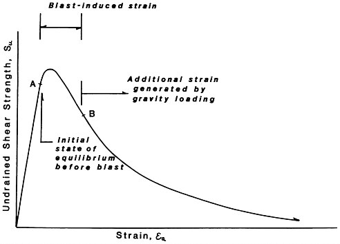
FIGURE 2.1 A schematic representation of the behavior of loose, saturated granular materials under rapid seismo-volcanic loading.
Further, the eruption-induced ground motions caused an additional shear stress large enough to rapidly increase pore water pressure, which decreased the static shear strength of the soil (Point B, Figure 2.1 ). The magnitude of the vibration-induced strain is directly proportional to the peak particle velocity generated by the vibrations and inversely proportional to the speed at which the shear waves travel within the sediment.
Once the available shear strength of the deposits has been reduced below the value required to maintain equilibrium, failure takes place and large displacements result. These displacements further increase the shear strain in the soils, resulting in continued shear strength reduction. The combination of rapid increase in moisture content, increase in vertical stress due to pyroclastic deposition, and cyclic loading due to volcanic tremors results in a process similar to soil “liquefaction,” where the soil behaves as a viscous liquid.
The debris flows of 1845 may support this model. No significant volcanic eruption was recorded prior to the flows and, in the author’s opinion, it is unlikely that ice melt was significant enough to trigger the debris flows. In fact, numerous large blocks of unmelted ice brought down within the debris flows were observed floating down the Magdalena River afterwards. The study team believes that the earthquake-generated ground motions recorded by Acosta (1845) could have played a major factor in “liquefying” large amounts of loose, saturated sediments deposited by previous eruptions near the summit, resulting in the debris flows.
The phreatic eruption on September 11, 1985 and its associated tremors were large enough to trigger a small debris flow, which advanced down the upper Azufrado River valley. The flow was relatively modest, possibly because of the moderate magnitude of the tremors, limited introduction of rain and ice-melt waters, and small additional sediment load stress. Due to limited available water and mobilized soil mass volume, the movement of this flow was counteracted by frictional forces along the flatter, 3°-5° inclination of the winding stretch of the Azufrado River canyon below the 3,000-m elevation.
AREAL EXTENT AND GRADIENT
The lahars generated by the November 13, 1985 eruption of the Ruiz volcano followed various paths, which are shown by some of the shaded areas in the preliminary volcanic risk map prepared by INGEOMINAS prior to the eruption ( Figure 2.2 ). The lahars descended from the summit along five river channels, three lahars flowing to the east and northeast, and two down the Las Nereidas and Molinos rivers and into the Chinchina River
valley to the west. The study team’s field efforts were concentrated on the three eastern and northeastern flows, which can be summarized as follows:
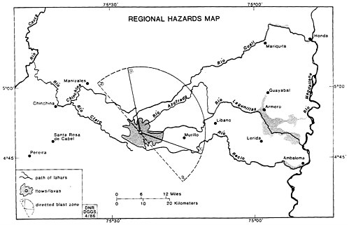
FIGURE 2.2 Sketch map showing volcanic hazards to the region surrounding Nevado del Ruiz. This map is derived from a map prepared by INGEOMINAS (1985) immediately prior to the November 13 eruption. The map accurately predicted the paths of the November 13 lahars.
The northeast lahar descended the Gualí River valley in a northeasterly direction and flowed approximately 58 km to the foothills at the western edge of the Magdalena plain. The lahar flowed out from the narrow canyon channel 1.5-2.0 km onto the plain, and then turned almost 90° to the north, continuing down the Gualí River valley. Mariquita, located at the base of the foothills on the south side of this northern turn of the river, was spared from serious damage.
Once on the alluvial plain, the lahar followed the Gualí River north 7-10 km, and then east to the Magdalena River. The elevated Tertiary sedimentary rock units on both sides of the Gualí River restricted the lahar flow to the river channel. Near its mouth, where the city of Honda is located, the Gualí River becomes entrenched in Quaternary sediments, forming a narrow valley 25-35 m deep. This incised section of the Gualí, near its junction with the Magdalena River, was subjected to substantial erosion of the valley walls by the lahar ( Figure 2.3 ). This erosion caused significant damage to and subsequent evacuation from a large number of structures along the river
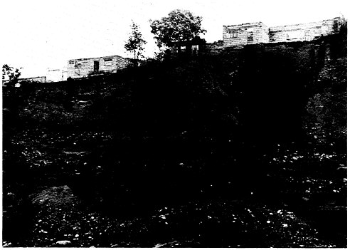
FIGURE 2.3 Erosion of bluffs along a sweeping curve of the Gualí River at Honda, just before entering the Magdalena River. Houses on bluffs above the river have been condemned and are mostly abandoned. (Photo by R. Updike, USGS.)
as it flowed through the city. Specific damage to these structures will be discussed later in the report.
The second major lahar, which destroyed the city of Armero, was initiated in the headwaters of two separate river channels: the Azufrado and the Lagunillas rivers. The upper Azufrado River valley is aligned with the 3-km-wide lahar-filled trench produced by previous volcanic eruptions. From the vicinity of the summit ice cap, the Azufrado River flows northeast for approximately 26 km to an elevation of 1,800 m, and then turns almost 150° south for another 10-12 km, at which point it joins the Lagunillas River.
The Lagunillas River, also starting near the summit, flows east for approximately 22-24 km to an elevation of about 2,200 m. The river then turns northeast for 8-9 km to its confluence with the Azufrado River. Downstream of this junction, the river retains the name Lagunillas River. The lahars initially descended both river valleys, and then continued in the single course below their juncture (temporary damming of the mud flows may have occurred at the valley intersection for short periods of time). The Lagunillas River descends from an approximate elevation of 1,800 m at the confluence
of the two rivers to an elevation of 400 m at the canyon mouth in a distance of about 20 km.
An inspection of contour line elevations in the vicinity of the summit indicates that the lahar initially descended along a steep slope of approximately 10 degrees to an elevation of 3,500-3,800 m. Below this elevation, the slope of the narrow, “V”-shaped valleys of the Azufrado and Lagunillas rivers decreases to an average of 4 degrees. A view into the mouth of the Lagunillas River canyon from the alluvial fan is shown in Figure 2.4 .
Once the mudflow reached the Magdalena plain, it spread radially into two main lobes ( Figure 2.5 ) separated by slightly higher ground. The central part of Armero, built on higher deposits from previous lahars, was not swept away by the 1985 mudflows ( Figure 2.6 ). The hills of Tertiary sedimentary rocks immediately east of Armero, with elevations up to 500 m above sea level, further prevented the lahars from flowing directly east into the Magdalena River. A detailed map of the mudflows in the immediate vicinity of Armero is shown in Figure 2.7 .
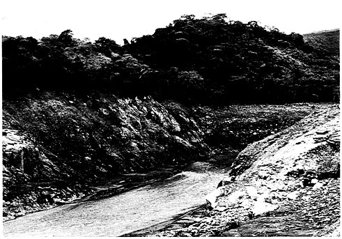
FIGURE 2.4 The mouth of the Lagunillas River canyon. Vegetation and soil were entirely removed from the floor and walls of the canyon to a point approximately 75 ft (25 m) above the river level, resulting in extensive exposure of bedrock. (Photo by R. Updike, USGS.)
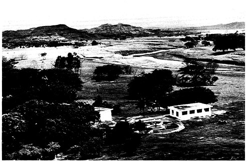
FIGURE 2.5 A view from near the mouth of the Lagunillas River canyon, looking down the fan toward the site of Armero (middle distance). Most of the panorama was covered by the lahars, the edge passing through the trees immediately beyond the water treatment plant in the foreground.
Once out of the canyon mouth, the largest amount of debris tended to follow a southeasterly direction along the course of the Lagunillas River ( Figure 2.7 ). Within the first 1.5-2.0 km downstream from the canyon mouth, the channel was substantially enlarged and deepened by mudflow erosion of the preexisting Quaternary alluvial deposits and minor amounts of the upper Tertiary strata. Downstream from Armero the main flows followed the southeast-oriented Lagunillas River channel for 2-3 km and then shifted into a more easterly direction north of the present Lagunillas River channel, which may have been partially filled by previous lahars (Acosta, 1845). The lahar continued to flow east for approximately 6 km on a relatively flat surface with an average inclination of 0.3-0.4 degrees (8 m/km) until forward momentum ceased on the broad plain.
The width of the mudflows on the Lagunillas floodplain varied from relatively narrow (300-400-m-wide) sections to 2.0-2.5-km-wide fans. The narrow stretches correspond to those locations where the flow passed through gaps in the sedimentary rock hills, which are as much as 100-150 m in relief
above the floodplain. The wide fans developed immediately behind these gaps due to the temporary damming of the mud flows when entering the narrow gaps. Aerial photographs taken within a few days after the eruption show high flow marks several meters above the present lahar surface that were left by these reservoirs of mud.
The northern branch of the lahar that spilled out of the Lagunillas River canyon into the floodplain swept away the northern section of Armero and abutted against sedimentary rock hills immediately northeast of the city. The flow turned north and followed the course of an existing creek (Santo Domingo Creek) for nearly 6 km, until it reached the Sabandija River where it terminated (about 1 km south of the town of Quayabal) ( Figure 2.7 ). At its widest point, this lobe of the Lagunillas lahar spread laterally as much as a kilometer in the broad valley of the Santo Domingo Creek. Farther north the flow was restricted to a width of 300-400 m until it reached the Sabandija River.
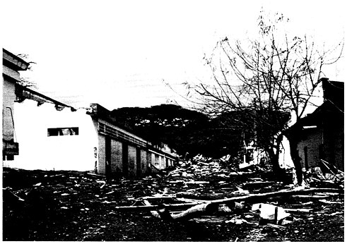
FIGURE 2.6 A business district in Armero on gently sloping terrain a few meters higher than most of the city. Buildings are erect, but the street is filled with mud and debris. Note that at the far end of the street (upstream direction), the mud level increases in height relative to doorways. The main force of the lahars was directed north and south of this area, due to topography. (Photo by R. Updike, USGS.)
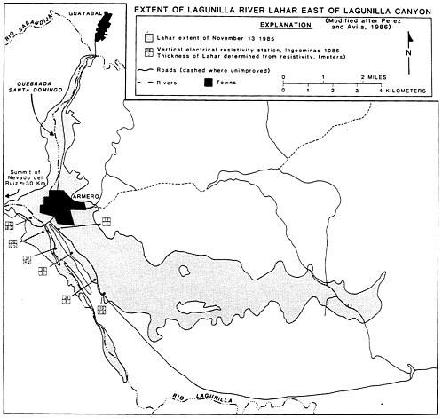
FIGURE 2.7 A map showing the extent of the Lagunillas River lahar beyond the mouth of the canyon west of Armero. Locations are referenced in the text of this report. Thicknesses of the lahar were determined by INGEOMINAS using electrical resistivity. (Map modified from Plazas and Vasquez, 1986.)
VELOCITY OF LAHARS
Estimates of the velocity of the mudflows triggered by the November 13, 1985 eruption are presented in Table 2.1 . These were obtained by establishing the times of arrival of a mudflow’s first wave at a few points along the flow path. The study team obtained the arrival times at three locations by interviewing eyewitnesses during the course of the team’s field work. The team assumed a 20-minute delay in initiation of the flows after the paroxysmal eruption began at 9:09 p.m. to account for the necessary processes of melting, saturation, and channelizing to occur. This delay is called the “mobilization time” and it is factored into the travel times listed in Table 2.1 .
TABLE 2.1 Mudflow Arrival Times and Average Lahar Velocities at Various Sites
|
Location |
Approximate Length of Flow, km |
Time of Arrival |
Estimated Travel Time * |
Average Velocity |
|
Murillo, Lagunillas |
17 |
9:52 p.m. |
23 min |
44 km/hr |
|
Armero, Lagunillas |
60 |
11:00 p.m. |
90 min |
40 km/hr |
|
Honda, Gualí Valley |
86 |
1:00 a.m. |
210 min |
25 km/hr |
|
* Time elapsed from the 9:09 p.m. eruption, minus 20-min mobilization time. |
||||
Table 2.1 indicates that the lahar developed a velocity of approximately 45 km/hr in the steeper highlands. The velocity was subsequently reduced due to increased friction and the lower inclination of slopes as the lahar passed out of the foothills at the mountain front onto the Magdalena plain. The estimated velocities agree well with a velocity calculated by Lowe and others (1986). These investigators made measurements of superelevation run-up where the lahar flowed around a sharp bend in the Lagunillas canyon approximately 1 km upstream from the mouth. Such measurements resulted in a calculated value of 43 km/hr. If less delay is assumed in initial mobilization of the flows, then resultant estimates of velocity will be less than those indicated in the table. Thus, it seems unlikely that mean velocities between the source areas and the mountain front exceeded 45-50 km/hr.
As the flows exited the mountains, the lateral constraints on the material rapidly diminished and the velocity undoubtedly decreased rapidly as well, due to the flow gradient, increased ratio of surface area versus volume (which affects frictional coefficients), and the energy-dispersive effect of the broad, undulating terrain. Interpolations of the average flow velocities downstream from the foothills toward the Magdalena River, suggest a mean flow velocity of approximately 10-15 km/hr on the plain. This estimate corresponds well with eyewitness accounts of persons who were saved by sprinting ahead of the flow for short distances to reach safety in the hills. Similar accounts were given by Acosta (1850) in the description of the 1845 lahars.
COMPOSITION OF THE LAHAR DEPOSITS
Deposits at various locations along the flow paths of the Lagunillas and Gualí lahars were inspected, sampled, and preliminarily analyzed. The approximate locations where the inspections were made and samples and measurements taken are given in Table 2.2 . Remnants of significant man-
TABLE 2.2 Site Location Inspected Along Flow Path
|
Site No. |
Approximate Location |
Site Identification |
Notes |
|
1 |
Main Road—3.0 km north of Armero |
La Caimana Creek |
Cluster of small boulders; structural behavior of railroad bridge; trees standing |
|
1A |
5.5 km north of Armero along flow |
Serpentarium |
Flow elevation; consolidation process of lahar deposits |
|
2 |
Main Road—2.1 km north of Armero |
|
General view of north branch of Lagunillas River lahar; boulder size and distribution; trees standing |
|
3 |
Warehouse—1.5 km |
Warehouse II |
Structural behavior of warehouse; traces of mudflow on the warehouse walls |
|
4 |
Armero |
Upper central part of town; high ground |
Remaining structures not swept away by the flow |
|
5 |
Armero |
Southern part of town; low ground |
Complete destruction of existing structures |
|
6 |
Armero—1.5 km in front of Lagunillas River canyon |
Warehouse I; western part of town |
Structural behavior of warehouse under frontal impact of mud wave |
|
7 |
Armero—1.0 to 1.5 km east of canyon mouth |
Lagunillas River channel |
Size and shape of boulders carried by mudflow |
|
8 |
Armero—eastern part of town Lagunillas |
Close sedimentary hills behind Armero |
Dam effect produced by high ground elevations |
|
9 |
River channel 1.0 km above canyon mouth |
|
Mark of flow elevation; “V”-shaped geometry of canyon |
|
10 |
6 km southeast of Armero, along Lagunillas River |
Lagunillas River |
General view of flow; boulder size and distribution; marks of mud |
|
10A |
12 km southeast of Armero |
South branch of Lagunillas mudflow |
Fine-grained lahar deposits typically encountered away from foothills |
|
11 |
Sedimentary hills behind Armero (east) |
Foothills |
Containment of flood advance by sedimentary hills east of Armero |
|
12 |
Honda |
Near junction of Gualí and Magdalena rivers |
Flood damage to building foundations |
|
13 |
Floodplain—1.5 km east of Gualí River canyon |
River plain of Gualí River |
Size of boulder transported by mudflow |
The initial flows in the upper river valleys involved a loose, granular mixture of silt, sand, gravel, and water ( Figure 2.8 ). As the flows descended, they eroded valley walls and floors, stripping away a wide range of materials ranging in size from the clays derived from altered bedrock and the organic layer to large alluvial boulders weighing several tons.
The particle size distribution, extent, and morphology of the lahar deposits at various locations beyond the mouths of canyons have similarities to typical alluvial fan deposits. Sediment transported down the mountain canyons was deposited gradually on the low-gradient plains as flow velocity—and, therefore, transport energy—diminished. Where lahars followed and overtopped the existing stream channels, levees of boulders and coarse gravels were built up along the channel margins. Although the largest boulders were observed in the primary axes of flow, smaller boulders up to about 0.5 m in
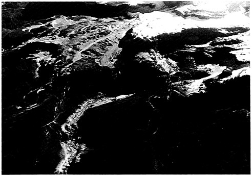
FIGURE 2.8 Oblique aerial photograph showing the distributary pattern of laharic deposits on the intermediate slopes below Nevado del Ruiz. Note the channelized debris flow in the canyon in lower center. (Photo by D. Herd, USGS.)
Overbank deposits, which spread out across the broad lowland valleys up to 2 km wide, deposited finer sediment beyond the levees, often partially or entirely burying the previously transported boulders. This general pattern of distribution of the coarse lahar deposits was observed in the floodplain areas near the edge of the foothills, within a zone 5-7 km from the mouth of the river canyons. Beyond this zone, the large boulders and cobbles decrease in maximum size and abundance and gradually disappear. These farthest lahar deposits consist mainly of gravel, sand, silt, clay, and debris.
The largest boulders encountered were observed within the first 1.0-1.5 km downstream from the canyons. For example, a large boulder weighing several tons was observed in the Lagunillas River channel at Site 7 ( Table 2.2 ), approximately 1.5 km east of the mouth of the canyon. The principal axes of the angular metamorphic rock boulder measured approximately 5 m × 3.5 m × 3 m. Smaller angular and rounded blocks, ranging from a
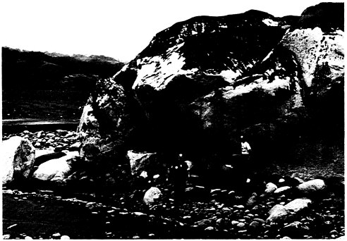
FIGURE 2.9 Two Colombian Red Cross workers stand in front of a monzonitic boulder in the floodplain of the Gualí River near Mariquita. The boulder, a local landmark, was transported approximately 400 m by the lahar. Note lahar sediment on top of the boulder and across the floodplain in the background. (Photo by R. Updike, USGS.)
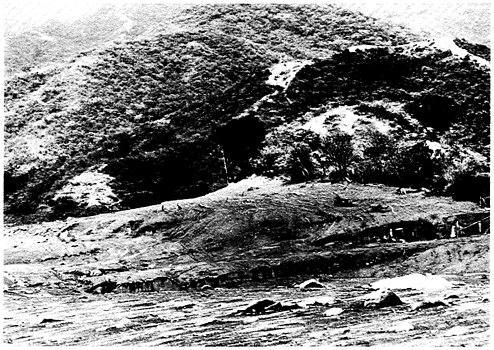
FIGURE 2.10 “The margin of safety” is the mudline drawn against this hillside north of Armero. Hundreds of survivors were found on these low hills. In the middle foreground, segments of building walls are exposed beneath the blanket of mud. (Photo by R. Updike, USGS.)
few centimeters to a few meters in diameter, were deposited around the large block in a matrix-supported fabric. Such a heterogeneous distribution of unsorted particle sizes—from sands to cobbles, with no apparent stratification—is typical of high-energy, turbulent-flow transport.
In the vicinity of Mariquita, on the Gualí River floodplain ( Figure 2.9 ) approximately 2.3 km downstream from the mouth of the Gualí River canyon (Site 13, Table 2.2 ), the study team encountered a large, angular boulder (approximately 8 m long, 6.5 m wide, and 4 m tall) surrounded by other angular boulders, as well as finer clastic sediments. Inhabitants of Mariquita reported that this boulder, which had been present prior to the November 13 lahar, had been moved approximately 300 m downstream by the flow that night. Finer clastic sediments of the lahar were found deposited on top of the boulder, suggesting that the lahar was at least 4 m thick as it passed this location.
Boulder distribution showed a remarkable association with preexisting stream channels. For example, Figure 2.10 shows the typical appearance of the northern branch of the Lagunillas River flow that followed the Santo
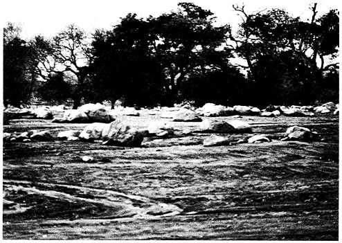
FIGURE 2.11 Large boulders (commonly more than 2-m diameter) littering former agricultural fields along the southern lobe of the Lagunillas lahar, approximately 3 km southeast of Armero. (Photo by R. Updike, USGS.)
Domingo Creek valley. The line of boulders found strewn along the bed of the Santo Domingo Creek (at Sites 2 and 3, Table 2.2 ) was not characteristic of the stream channel prior to November 13, 1985. Boulders forming the levees on the edge of the stream were approximately 1.5-2.0 m in maximum diameter. There was a gradual decrease in the size of boulders deposited away from the river bed.
Another boulder-strewn tract was observed along the southern lahar branch that followed the preexisting Lagunillas River channel ( Figure 2.11 ). Again, large boulders (approximately 1.5-2.0 m in diameter) were strewn along both sides of the Lagunillas River channel; lesser-diameter boulders shown in Figure 2.11 were deposited in both directions away from the channel. The boulders were found approximately 6 km downstream from the mouth of the Lagunillas River canyon.
THICKNESS OF LAHAR DEPOSITS
A simple method for determining the thickness of the viscous mudflows at various locations along their flow paths was to make estimations by
measuring the height of remnant mud tracks above the ground surface on various physical features that survived the destruction. Mud track elevations on the walls of the Lagunillas River canyon, approximately 1.0 km upstream of the canyon mouth (Site 9, Table 2.2 ), were estimated to be 30 m above the valley floor ( Figure 2.4 ).
Once the mudflows emerged from the canyon mouths onto open, gently sloping terrain, they spread laterally, reducing in thickness and simultaneously depositing substantial amounts of sediment. The thickness of the Lagunillas mudflow was measured at the remnants of a warehouse located 1.0 km directly east of the mouth of the Lagunillas River canyon (warehouse I, Site 6, Table 2.2 ). Mud tracks on the walls of the warehouse, which is approximately 7 m high, indicated that at peak discharge the flow reached the top of the building ( Figure 2.12 ).
Farther east, in central Armero, at an approximate distance of 2.5 km from the canyon mouth, the accounts of survivors who spent the night on top of the hospital indicate that the mudflow almost reached the roof of the building. The study team observed that the lahar deposits at this location completely filled the first floor of the hospital building and partially filled
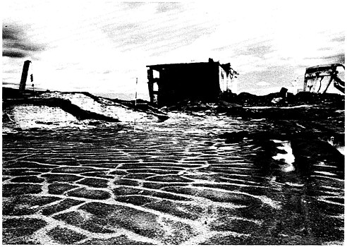
FIGURE 2.12 A granary complex located within Armero. Note the polygonal jointing of laharic mud in foreground. At peak discharge, the flow reached the top of the building in the background. (Photo by R. Updike, USGS.)
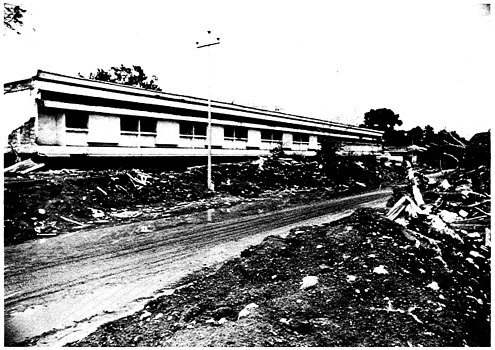
FIGURE 2.13 The public hospital in Armero. Two stories were constructed above grade and one below grade. Only the topmost story remained above mud level, sustaining minor damages. (Photo by R. Updike, USGS.)
the second floor ( Figure 2.13 ). The height of the first floor was measured to be approximately 2.75-3.0 m and the estimated total thickness at this location is about 4.0 m.
The thickness of the Lagunillas River mudflow was further reduced downstream as it bifurcated into the northern and southern lobes. While in the central business district the peak flow must have been several meters thick (no structures remain to record a mudline), toward the south the thickness decreased to 1-4 m within a distance of about 1 km. In the southeast section of the city, the walls of many homes and shops remained erect even though the mudflow entered virtually all buildings, filling them to a depth ranging from a few centimeters to about 2 m ( Figure 2.14 ). The fact that many walls remained upright suggests that forward momentum in this section of the city had diminished drastically compared to the city center.
Along the northern branch of the Lagunillas lahar, at a location 0.5 km north of Armero (2.5 km from the canyon mouth), the height of the mud traces left on a large standing tree reached approximately 4-4.5 m above the ground surface; debris was entangled in tree limbs at this height. In addi-
tion, the study team estimated that about 1 m of lahar deposit covers the original ground surface for a total lahar thickness of about 5 m.
About 1 km farther downstream from the tree described above (approximately 3.75 km from the canyon), mudflow elevations were measured in another warehouse ( Figure 2.15 ). This structure, identified as warehouse II in this report (Site 3, Table 2.2 ), is a 45-m-long structure located near the main Mariquita-Armero highway. A view toward the downstream side of the warehouse ( Figure 2.16 ) shows that the long axis of the warehouse is in an east-west direction perpendicular to the course of the Santo Domingo Creek, which runs between the warehouse and the hills shown in the background. The far corner of the warehouse is thus nearest to the creek, at a distance of approximately 50-75 m. Traces of mud left on the warehouse walls indicate that in sections of the warehouse nearer to the creek the lahar reached an approximate height of 2.5 m above the present ground surface, breaking the masonry wall panels between columns. Approximately 1.5 m
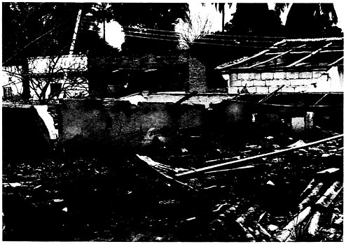
FIGURE 2.14 A residential area of Armero situated near the margin of the mudflows. Although the buildings remained intact, mudflows nearly reached the top of the doorways. Roofs and wall members partially collapsed due to torsional stresses caused by the impacting mud. Most buildings seen here were constructed of nonreinforced concrete or abode block. (Photo by R. Updike, USGS.)
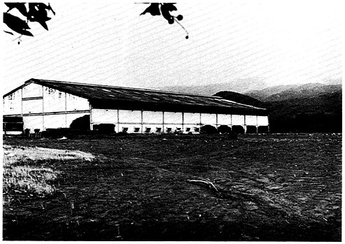
FIGURE 2.15 An engineered granary structure 4 km north of Armero. Construction consisted of steel rebar-reinforced concrete pillars and beams with nonreinforced concrete block fill-in between pillars. This view is of the downstream side of the building where pillars remain but concrete block has been carried away. (Photo by R. Updike, USGS.)
of consolidated sediment covers the warehouse floor, so that total lahar thickness during peak flow was about 4.0 m.
Farther away from the creek, the elevation of the mudflow significantly decreased, as indicated by the mudline on the remaining wall panels about 2.0 m above the warehouse floor. A close-up view of the interior of the warehouse shows the upstream corner closest to the creek bed. The mudflow traces on the exposed column reached an approximate height of 2.25 m above the consolidated lahar surface. The boulder-strewn tracts along both sides of the creek are visible in the background and the estimated thickness of the lahar cover at this point is about 2.0 m. The fine-grained materials in the foreground and directly behind the warehouse are a mixture of silt and sand, with some gravel and occasional boulders.
Approximately 1.5 km north of warehouse II, the study team examined the lahar deposits near a former ranch. Although the buildings were still standing, moderate structural damage had occurred. Splash-up above the mudline and flow marks observed in the mud ( Figure 2.17 ) indicated that
the flow was moving rapidly and turbulently at the time of impact. The mud tracks on the buildings were approximately 1.5 m above the original ground surface.
The edge of the lahar was found in a field a few hundred meters east of the ranch buildings. This outer boundary gradually thinned to a few centimeters of thickness at its transition to the cultivated field. Even here, however, the study team found that massive debris had been in transport (e.g., railroad tracks, tree trunks). This suggests that as the flow passed through this area it was significantly thicker than might be assumed from the sediment deposits left behind. This impression was further supported downstream where a tributary of Santo Domingo Creek passes beneath the Armero-Mariquita highway. Considerable debris was piled against and over the reinforced concrete culvert beneath the roadway and the mud beneath the culvert was approximately 2 m thick. The fact that the lahar overtopped the culvert indicates that it was up to 4 m thick at this point.
The thickness of the northern branch of the Lagunillas lahar was measured near its terminus at the National Serpentarium Administration Building, located approximately 5.5 km north of Armero (Site 1A, Table 2.2 ). A
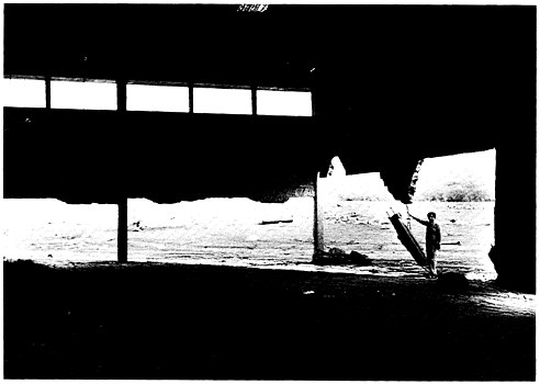
FIGURE 2.16 Upstream corner of building in Figure 2.14 . G. Fernandez stands by pillar dangling by rebar. Approximately 1.3 m of mudflow debris covers the interior floors of the building. (Photo by R. Updike, USGS.)
FIGURE 2.17 An outbuilding at a ranch about 5 km downstream from Armero. Note “blow-out” of windows, typical of buildings that remained standing. Also note the sweeping pattern of the upper flow zone, the spatter on the wall above the flow, and the unmarked wall on the downstream wall at right, all of which suggest remarkable speed, turbulence, and viscosity. (Photo by R. Updike, USGS.)
clear trace of the flow line elevation was left on the walls of this building ( Figure 2.18 ). The flow line reached an elevation of approximately 0.9 m above the consolidated lahar surface, which was about 0.3 m thick over the original land surface. A summary of the measured depths of the Lagunillas River lahar at the various locations described above is given in Table 2.3 .
Additional measurements of the thickness of the lahar deposits in the floodplain near Armero were carried out in 1986 by INGEOMINAS using electrical resistivity methods. Vertical profiling was conducted at seven locations on the lahar using a Schlumberger array. Figure 2.7 shows the sites where the resistivity measurements were taken, identified with the numbers 17, 18, 19, 26, 32, 33, and 34. The measurements were all made on the southern branch of the lahar, at distances from the mouth of the canyon ranging from 1.0 to 5.0 km. The thicknesses of the lahar deposits measured at these seven locations are recorded in Table 2.4 and indicate a range from 0.5 to 8.3 m. An inspection of the locations where the measurements were taken indicates that the smaller values were recorded in the vicinity of
TABLE 2.3 Estimated Thickness of Lagunillas Lahar
|
Site No. |
Approximate Location |
Distance from Canyon Mouth |
Depth of Flow |
Notes |
|
9 |
Lagunillas River valley: 1 km upstream canyon’s mouth |
1.0 km upstream |
30 m above river bed |
Estimated |
|
6 |
Armero warehouse I: on west side of town |
1.0 km in front of canyon’s mouth |
7-8 m |
Measured |
|
|
Armero: tall trees 300 m north of town |
2.5 km in front of canyon’s mouth |
4-5 m at mudline + 1.5 m of sediments = 5.5-6.5 m total depth |
Measured |
|
3 |
Warehouse II: 1.5 km north of Armero |
3 km north of canyon’s mouth |
2.5 m at mudline + 1.5 m of sediment = 4.0 m total depth |
Measured |
|
1A |
Serpentarium: 5.5 km north of Armero |
6.0 km north of canyon’s mouth |
0.9 m at mudline + 0.3 m of sediment = 1.2 m total depth |
Measured |
TABLE 2.4 Measured Thickness of Lahar Deposits in the Vicinity of Armero
|
Measurement No. |
Approximate Distance from Canyon (km) |
Measured Thickness of Deposits (m) |
|
17 |
1.18 |
8.3 |
|
26 |
2.0 |
0.5 |
|
18 |
2.3 |
3.0 |
|
32 |
2.75 |
4.2 |
|
33 |
3.12 |
8.0 |
|
34 |
4.8 |
8.0 |
|
19 |
5.4 |
1.8 |
Estimates of the height of the mudflow upstream from the junction between the Gualí and Magdalena rivers were also obtained during field inspection. Here, the Gualí River valley narrows considerably into an incised channel as it passes through the city of Honda. The mudflow in the Gualí River valley was contained within the steep banks bounding the river floodplain. Upstream of the narrow incised section the lahar covered the open floodplain of the river to a height of 1.5-2 m above the river bed. The marks of the mudflow can be seen in the partially collapsed building in the background—the abandoned remains of an electrical power plant for Honda. The surface of the mudflow, however, was substantially elevated at the entrance into the narrower portion of the river channel downstream. The narrower channel section resulted in a constriction of the mudflow, raising its height in the channel 7-8 m above the river bed. Traces of the mudflow and the considerable erosion and mass wasting of the bluffs it caused were visible. These observations strongly suggest that the lahar at Honda was highly fluid. The erosive problems downstream in Honda will be discussed later.
CONSOLIDATION OF LAHAR DEPOSITS
Once the forward momentum of the materials had been arrested, a consolidation process began to take place in the loose, saturated materials. The sediment began to consolidate under its own weight, with most of the drainage taking place through the upper surface. Eyewitness accounts indicate that on the morning after the eruption large amounts of water were observed seeping upward to the mud surface, establishing various drainage paths across the surface of the recently deposited materials. The amount of water coming out of the sediment rapidly decreased within two to four days, according to these accounts. During its inspection three months after the eruption, the study team found that in some low-lying areas the surface of the deposits was still moist and that small amounts of surface dewatering could occasionally be observed.
Accounts by eyewitnesses reaching Armero in the early hours of the morning after the eruption indicate that the surface water coming out of the lahar was hot enough to burn the flesh of survivors and that associated vapors had a strong sulfuric odor. In addition, the lahar was too soft to traverse on foot or by vehicle for one to three days after the eruption. Thereafter, the deposits hardened rapidly. This consolidation process made the digging out of trapped survivors difficult for rescue workers who could
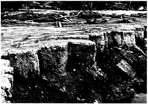
FIGURE 2.19 Vertical exposure of the upper fine-grained zone of the lahar downstream from Armero. This zone is believed to have behaved as a quasiviscous suspended flow. Note the rudimentary columnar jointing extending nearly 1 m into the sediment from a polygonal fracture pattern on the surface. Penetrometer values consistently exceeded the 3.0 tsf limit of the instrument, used on both the surface and exposed face. (Photo by R. Updike, USGS.)
of consolidated sediment covers the warehouse floor, so that total lahar thickness during peak flow was about 4.0 m.not, at first, safely reach the victims and, when they could, found the people severely burned and encased in hardened mud.
At the time of the field inspection, the primary consolidation was nearly complete, and shrinkage and desiccation of the lahar deposits were well under way. A pronounced pattern of polygonal jointing of the fine-grained lahar deposits was observed at several locations, for example, in the immediate vicinity of warehouse I (Site 6, Table 2.2 ). An identical polygonal joint pattern was observed at the Serpentarium (Site 1A, Table 2.2 ). At an excavated pit in the southeast sector of Armero, these desiccation polygons were found to be columnar joints extending nearly 1 m into the upper, fine-grained phase ( Figure 2.19 ). The unconfined compressive strength of the silty fine sands in this upper 1-m-thick zone, as measured on both the flow surface and the exposed face, consistently yielded pocket penetrometer values that exceeded the 3.0 tsf limit of the instrument. Penetrometer resistance
measurements taken in the upper, fine-grained deposits at sites in the vicinity of the Serpentarium were consistently in excess of 1.5 tsf.
Shrinkage and desiccation of the lahar deposits were observed in the mudflow materials along exterior walls of the Administration Building in the Serpentarium complex ( Figure 2.20 ). This observation, in conjunction with the mud traces left on the wall of the building, provided an indication of the process of sedimentation, primary consolidation, partial desiccation, and shrinkage that have occurred since November 13, 1985. A caretaker who survived the disaster at the Serpentarium and remained there for several weeks after the event was able to confirm these conclusions through his own observations.
A quantitative evaluation of the reduction in the thickness of the initial mudflow was carried out based on measurement of the uniformly horizontal mudflow tracks left on the wall of the Administration Building. The surface of the mudflow reached a height of approximately 90 cm above the initial ground surface. The velocity of the mudflow at this location (approximately 5.5 km north of Armero) was apparently very low, presumably
FIGURE 2.20 Foundation corner of building in Figure 2.18 . The desiccation has drawn the silty sand away from the foundation as consolidation continues. (Photo by R. Updike, USGS.)
After three months, the maximum mudflow thickness of 90 cm had been reduced to a hard desiccated layer of fine-grained materials from 30-35 cm thick. A close inspection of the mud tracks left on the wall revealed the presence of a heavy, dense layer of sandy mud on the wall at a height of 30 cm above the desiccated sediment surface. In the remaining upper 25-30 cm, the trace of mud consisted of a very light silt, having the appearance and texture of chalky paint. The study team believes that within the first 48 hours the 90-cm initial thickness had decreased 25 cm due to rapid sedimentation of the suspended material. The dewatering at the surface was accommodated by slow drainage to topographically lower areas. The remaining 65-cm-thick layer of loose, saturated sediment underwent a rapid primary consolidation process and partial shrinkage due to desiccation, which further reduced the thickness to approximately 30-35 cm.
If an assumption is made that most of the lahar’s thickness reduction took place during the primary consolidation process, an estimated value of the unit strain induced can be obtained using Equation 2.1 as follows:
(2.1)
Where S = settlement of the layer
e = change in void during primary consolidation process
eo = initial void ratio of the deposits before primary consolidation started
H = initial thickness of the layer
Replacing values (Equation 2.2), the unit strain can be estimated as follows:
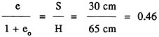
(2.2)
Based on its observations, the study team concluded that as the lahars emerged from the mountain canyons a crudely two-layered transport medium developed. The lower layer was dominated by tractive flow. This was the zone in which most of the cobble and boulder fraction was concentrated and transported. Above this zone, suspended flow predominated, containing sediments ranging from clays to gravels, with attendant debris entrained. As with other types of debris flows, basal shear stresses on the perimeter (bottom and, if present, confining walls) are dictated by depth, viscosity, density, and velocity of the flow. As has been shown, near the canyon
mouths flow depth ranged up to several meters and velocities probably exceeded 40 km/hr. In the downstream direction thickness decreased (e.g., to less than 1 m at the Serpentarium) and velocity diminished to near zero. As a result, the tractive transport of coarse sediment decreased significantly within the first 5-7 km from the canyon mouths. Thus, in the distal areas, such as to the north and east of Armero, tractive boulder flow diminished rapidly. Similarly, if the channel of the Gualí River had remained wide at Honda, tractive erosion of the channel and bluffs would not have been nearly so severe. However, because of relatively large discharge through an area with a constricted cross-section, tractive energy was concentrated on the channel perimeter.
The study team believes that the upper suspended flow regime most accurately characterized the lahar as it first began to descend the mountain. The presence and magnitude of the tractive forces, which were so destructive downstream, are dependent upon velocity, flow thickness, viscosity of the medium, and flow boundary conditions. In the opinion of the study team, the initial void ratio and density of the initial lahars can be reconstructed by back-calculating through the consolidation phenomenon in the distal areas where the primary transporting medium is better isolated.
The tangential shear stresses resulting from the down-gradient flow of a lahar are responsible for the buoyancy effects keeping the various sizes of clasts “aloft” and in motion in the flow. As these stresses are reduced, sedimentation of the clasts and consolidation of the material around the clasts will begin almost immediately. Observations and discussions with eyewitnesses indicate that the lahars began to undergo sedimentation even while still in motion.
Simultaneously, as the suspended particles began to settle through the fluid medium, the primary consolidation process takes place at a very rapid rate. The presence of large amounts of volatile gas within the fluid as well as the elevated temperature of that fluid probably initially delayed the consolidation process. In this regard, two members of the Colombian Red Cross reported that on November 14 a strong sulfur odor and steam cloud lingered over the Lagunillas lahar. Several eyewitness accounts indicated that a substantial portion of the primary consolidation occurred within a few days to a few weeks after deposition.
The fluidity of the Lagunillas lahar was noted in a partially excavated pit around a jeep buried in the lahar deposits. The interior of the vehicle was evenly filled with sediment. The jeep excavation (near Site 3, Table 2.2 ) was approximately 0.7 m deep at the time of our inspection, and the lahar materials exposed were hard (pocket penetrometer values in excess of 1.5 tsf) and fine-grained. The total depth of the lahar deposit at this location was estimated at 2.5 m.
In the central part of Armero the study team found bulldozer excavations
to a depth of 2.0 m. The lahar deposits exposed in the walls of the excavation were hard and, at the time of excavation, consistency was firm enough to maintain a vertical-cut wall. This observation indicates that a substantial thickness of the lahar had densified and strengthened in a relatively short period of time.
Other phenomena besides desiccation and shrinkage could have contributed to the thorough and rapid hardening of the lahar deposits, for example, the development of a cementation between particles as a result of the combination of the acidic fluids and elevated temperatures within the voids, depositing chemical precipitates in intergranular voids during cooling. Such precipitates result from solution interaction with iron-magnesium silicate minerals, which we observed to be abundant in the silt-sand (matrix) of the lahar. Iron oxide precipitates were not immediately apparent, but were common in all areas of the lahars.


