
9
The Implications of Climatic Change for Streamflow and Water Supply in the Colorado Basin
Linda Nash
Pacific Institute for Studies in Development,
Environment, and Security
Berkeley, California
INTRODUCTION
The Colorado River is one of the most important river systems in the United States. Although not a large river even by North American standards, the Colorado flows through some of the most arid regions of the country and is the sole source of water for a region with extensive agriculture, large cities, and a diverse ecosystem. Existing global models suggest that climatic changes will have dramatic impacts on water resources. Water availability, quality, and demand will be affected by higher temperatures, new precipitation patterns, rising sea level, and changes in storm frequency and intensity. These changes will be important to the Colorado River basin because of their effect on water supply and water management—issues already hotly contested in the region. Moreover, potential climatic impacts will have significant ramifications for decisions about water allocations and water rights that are likely to be made in the coming decade.
Despite recent advances in modeling the atmosphere, large uncertainties remain about the details of regional hydrologic changes. Until current climate models improve both their spatial resolutions and their hydrologic parameterizations, information on the hydrologic effects of global climatic changes can best be obtained using regional hydrologic models. At this time such studies are limited to sensitivity analyses that describe the vulnerability of hydrologic basins to a range of plausible climate scenarios. While these scenarios cannot be regarded as reliable predictions of future conditions, they do provide insights into regional vulnerabilities.
A variety of techniques are available for studying the hydrologic impacts of climatic change, including stochastic methods that rely primarily on statistical techniques and deterministic or conceptual models that use physically based, mathematical descriptions of hydrologic phenomena. Because climatic changes are expected to alter underlying statistical relationships among variables, stochastic models are probably inappropriate for climate-impact studies. In contrast, deterministic techniques should be more robust so long as the modeled processes (such as percolation, soil-moisture storage, and snow melt) are not expected to change significantly under a carbon dioxide-altered climate. To date, climate-impact studies on the Colorado River basin have been limited to stochastic methods (Revelle and Waggoner, 1983; Stockton and Boggess, 1979). In contrast, this project used a conceptual hydrologic model to study the sensitivity of the basin to greenhouse warming.
The large size of the Colorado basin complicates the development of a hydrologic model. This study used a conceptual model developed and operated by the National Weather Service River Forecasting Service (NWSRFS) in Salt Lake City, Utah (Burnash et al., 1974; Anderson, 1973). This model has advantages and limitations, described in detail in Nash and Gleick (1991), but its success as a forecasting tool provides reason for believing that the model has the capability to simulate the effects of changes in temperature and precipitation. The NWSRFS models the upper Colorado basin as a series of approximately 50 small subbasins that are linked together. In addition, an aggregated model has been developed that divides the entire upper Colorado basin into two elevation zones and uses a limited number of meteorological stations to predict inflow into Lake Powell. In addition to this two-elevation model, we selected three subbasins that were known to make a substantial contribution to basin flow: the White River at Meeker, the East River at Almont, and the Animas River at Durango.
To assess the potential impacts of climatic change on runoff in the Colorado River basin, scenarios of changes in temperature and precipitation were used as inputs into the NWSRFS model. For this study, we relied on purely hypothetical scenarios as well as scenarios derived from the outputs of general circulation models (GCMs). These scenarios are listed in Table 9.1. The baseline data for the model consist of six-hourly data for the years 1949 through 1983, inclusive.
Using the results of the NWSRFS model, we chose a range of plausible runoff scenarios with which to assess the sensitivity of
the basin to changes in water supply. The impacts of changes in runoff on water deliveries, hydropower production, reservoir levels, and several other variables were studied with the U.S. Bureau of Reclamation's Colorado River Simulation System (CRSS). The CRSS is a reservoir-system simulation model that tracks streamflow and water supply throughout the Colorado River basin. The CRSS incorporates the legal and administrative requirements that affect water supply in the basin and is the most detailed simulation model currently available for the Colorado River. It serves as the Bureau of Reclamation's primary tool for studying the operation of the river and the impacts of operational changes and projected developments in the basin. The model is documented in the U.S. Department of the Interior (DOI) publication Colorado River Simulation System Overview (DOI, 1987).
The CRSS uses historical streamflow data (a 78-year record, extending from 1906 to 1983) to analyze possible future conditions. The input to the model is ''natural'' streamflow—defined as historical flow data adjusted to remove the effects of human development—at 29 gaging stations throughout the basin. The output from the model is actual streamflow, reservoir levels, hydropower production, reservoir spills, salinity, and water deliveries. The model incorporates a large set of supply constraints and decision rules that determine reservoir operation, including the allocation of shortages and surpluses among various water users. In no sense does the model predict future shortages or surpluses, but it does portray the sensitivity of those outcomes to particular inputs or operating parameters.
For the purposes of this study, operating procedures (such as rule curves and target storages) were held constant, and the natural flow database was uniformly altered by plus or minus 5, 10, and 20 percent. These scenarios are consistent with results generated by the NWSRFS model. Although it is likely that operational parameters would be adjusted over time to increase the system's efficiency with respect to changed hydrologic conditions, such changes would be implemented slowly and only after a general acknowledgment of changed conditions. At this point, it is difficult to estimate to what extent changes in operations might mitigate the impacts of changes in flow; this is an area for further research. Our results summarize a model run of 78 years in which natural flows were altered by the specified percentage at all 29 input stations. Reservoir evaporation rates were unchanged, even though they would be expected to increase under conditions of higher temperature. The demand data used in these runs were the
TABLE 9.1 Climate-Change Scenarios Used in the NWSRFS Model.
|
|
Two–Elevation |
White River |
East River |
Animas River |
|
Hypothetical |
||||
|
T+2°C, P-20% |
-- |
X |
X |
X |
|
T+2°C, P-10% |
X |
X |
X |
X |
|
T+2°C, P+0 |
X |
X |
X |
X |
|
T+2°C, P+10% |
X |
X |
X |
X |
|
T+2°C, P+20% |
-- |
X |
X |
X |
|
T+4°C, P-20 |
X |
X |
X |
X |
|
T+4°C, P-10% |
X |
X |
X |
X |
|
T+4°C, P+0 |
X |
X |
X |
X |
|
T+4°C, P+10% |
X |
X |
X |
X |
|
T+4°C, P+20% |
X |
X |
X |
X |
|
GCM1 |
||||
|
GISS 1: T+4.8°C, P+20% |
-- |
X |
-- |
-- |
|
GISS 2: T+4.9°C, P+10% |
X |
-- |
X |
X |
|
GFDL: T+4.7°C, P+0 |
X |
X |
X |
|
|
UKMO 1: T+6.8°C, P+30% |
X |
X |
-- |
-- |
|
UKMO 2: T+6.9°C, P+10% |
X |
X |
X |
X |
|
NOTE: 1 All GCM scenarios represent annual average changes for an equilibrium (2×CO2) run. |
||||
Bureau of Reclamation's projections for the year 2040 and were held constant for the period analyzed. For the model runs presented in this paper, the total amount of reservoir storage at the beginning of the run was approximately 36.5 million acre-feet (maf), or about 60 percent of the system's total storage capacity.
RESULTS
Hydrologic (NWSRFS) Model
Large changes in the magnitude of annual flow in the Colorado basin may result from plausible climatic changes (Tables 9.2 through 9.5). A 2°C rise in temperature corresponds to a decrease in runoff of 4 percent on the White River, 9 percent on the East River, and 7 percent on the Animas River. For the two-elevation model, a tem-
TABLE 9.2 Annual In-Flow (taf) Into Lake Powell (Two-Elevation Model) for All Scenarios.
|
Scenario |
Mean1 |
SD |
CV |
Minimum |
Maximum |
|
Base |
10940 |
2983 |
0.27 |
4481 |
17040 |
|
T+2° P-10% |
8386 (-23.3%) |
2418 |
0.29 |
3357 (-25.1%) |
12940 (-24.1%) |
|
T+2° P+0 |
9656 (-11.7%) |
2727 |
0.28 |
3924 (-12.4%) |
14330 (-15.5%) |
|
T+2° P+10% |
11000 (0.6%) |
3046 |
0.28 |
4504 (0.5%) |
16350 (-4.0%) |
|
T+4° P-20% |
6447 (-41.0%) |
1970 |
0.31 |
2520 (-43.8%) |
11480 (-32.6%) |
|
T+4° P-10% |
7522 (-31.2%) |
2260 |
0.30 |
2892 (-35.5%) |
12480 (-26.8%) |
|
T+4° P+0 |
8668 (-20.7%) |
2554 |
0.30 |
3373 (-24.0%) |
13490 (-20.8%) |
|
T+4° P+10% |
9879 (-9.7%) |
2854 |
0.29 |
3911 (-12.7%) |
14530 (-14.8%) |
|
T+4° P+20% |
11150 (2.0%) |
3162 |
0.28 |
4443 (-0.9%) |
16180 (5.1%) |
|
GISS 2 |
9444 (-13.6%) |
2804 |
0.30 |
3624 (-19.1%) |
14220 (-16.5%) |
|
GFDL |
8369 (-23.5%) |
2514 |
0.30 |
3180 (-29.0%) |
13270 (-22.1%) |
|
UKMO 1 |
10950 (0.2%) |
3240 |
0.30 |
4107 (-8.3%) |
16070 (-5.7%) |
|
UKMO 2 |
8639 (-21.0%) |
2693 |
0.31 |
3173 (-29.2%) |
13296 (-18.3%) |
|
NOTE: 1 Numbers in parentheses represent percent change from the base case. |
|||||
TABLE 9.3 Annual Flow (taf) of the White River for All Scenarios.
|
Scenario |
Mean1 |
SD |
CV |
Minimum |
Maximum |
|
Base |
434.9 |
104.5 |
0.24 |
242.8 |
670.5 |
|
T+2° P-20% |
335.1 (-22.9%) |
70.6 |
0.21 |
193.6 (-20.3%) |
474.7 (-29.2%) |
|
T+2° P-10% |
374.6 (-13.9%) |
82.9 |
0.22 |
214.6 (-11.6%) |
541.1 (-19.3%) |
|
T+2° P+0 |
417.0 (-4.1%) |
97.5 |
0.23 |
234.7 (-3.4%) |
608.7 (-9.2%) |
|
T+2° P+10% |
465.1 (-7.0%) |
114.8 |
0.25 |
255.0 (-5.0%) |
697.1 (4.0%) |
|
T+2° P+20% |
515.7 (18.6%) |
132.9 |
0.26 |
279.0 (14.9%) |
788.6 (17.6%) |
|
T+4° P-20% |
320.9 (-26.2%) |
70.0 |
0.22 |
180.7 (-25.6%) |
468 (-30.2%) |
|
T+4° P-10% |
357.6 (-17.8%) |
80.6 |
0.23 |
200.6 (-17.4%) |
532.4 (-20.6%) |
|
T+4° P+0 |
396.9 (-8.7%) |
92.9 |
0.23 |
221.5 (-8.8%) |
599.7 (-10.6%) |
|
T+4° P+10% |
440.4 (-1.3%) |
107.9 |
0.24 |
241.7 (-0.5%) |
666.9 (-0.5%) |
|
T+4° P+20% |
487.9 (12.2%) |
126.2 |
0.26 |
264.0 (8.7%) |
756.2 (12.8%) |
|
GISS 1 |
476.2 (9.6%) |
122.9 |
0.26 |
252.9 (4.2%) |
746.2 (11.3%) |
|
GFDL |
389.7 (-10.4%) |
91.7 |
0.24 |
214.1 (-11.8%) |
599.7 (-10.6%) |
|
UKMO 1 |
488.5 (-12.3%) |
128.3 |
0.26 |
250.2 (3.0%) |
790.1 (17.8%) |
|
UKMO 2 |
401.3 (-7.7%) |
97.4 |
0.24 |
211.8 (-12.8%) |
640.4 (-4.5%) |
|
NOTE: 1 Numbers in parentheses represent percent change from the base case. |
|||||
TABLE 9.4 Annual Flow (taf) of the East River for All Scenarios.
|
Scenario |
Mean1 |
SD |
CV |
Minimum |
Maximum |
|
Base |
230.7 |
84.9 |
0.37 |
76.9 |
477.0 |
|
T+2° P-20% |
165.8 (-27.6%) |
60.6 |
0.36 |
60.2 (-22.8%) |
358.6 (-24.8%) |
|
T+2° P-10% |
186.9 (-18.7%) |
69.1 |
0 37 |
66.4 (-14.0%) |
401.8 (-15.8%) |
|
T+2° P+0 |
209.4 (-9.1%) |
77.8 |
0.37 |
72.5 (-5.8%) |
446.1 (-6.5%) |
|
T+2° P+10% |
233.5 (1.3%) |
86.2 |
0.37 |
79.1 (2.8%) |
490.5 (2.8%) |
|
T+2° P+20% |
258.7 (12.3%) |
94.3 |
0.36 |
86.4 (12.2%) |
535.0 (12.2%) |
|
T+4° P-20% |
153.8 (-33.1%) |
58.8 |
0.38 |
54.4 (-29.3%) |
348.9 (-26.8%) |
|
T+4° P-10% |
172.8 (-25.0%) |
66.9 |
0.39 |
61.6 (-19.9%) |
388.4 (-18.6%) |
|
T+4° P+0 |
192.8 (-16.5%) |
74.9 |
0.39 |
68.8 (-10.6%) |
428.6 (-10.2%) |
|
T+4° P+10% |
223.4 (-3.4%) |
86.3 |
0.37 |
77.6 (0.8%) |
487.0 (2.1%) |
|
T+4° P+20% |
246.4 (6.6%) |
93.8 |
0.38 |
84.7 (10.1%) |
528.3 (10.8%) |
|
GISS 2 |
205.6 (-11.2%) |
80.9 |
0.39 |
70.2 (-8.8%) |
456.2 (-4.4%) |
|
GFDL |
187.0 (-19.1%) |
73.4 |
0.39 |
64.6 (-16.1%) |
420.2 (-11.9%) |
|
UKMO 2 |
187.6 (-19.0%) |
76.2 |
0.41 |
64.2 (-16.6%) |
438.9 (-8.0%) |
|
NOTE: 1 Numbers in parentheses represent percent change from the base case. |
|||||
TABLE 9.5 Annual Flow (taf) of the Animas River for All Scenarios.
|
Scenario |
Mean1 |
SD |
CV |
Minimum |
Maximum |
|
Base |
550.6 |
192.5 |
0.35 |
240.4 |
941.7 |
|
T+2° P-20% |
406.6 (-26.1%) |
143.5 |
0.35 |
165.9 (-31.0%) |
682.6 (-27.5%) |
|
T+2° P-10% |
458.6 (-16.7%) |
162.3 |
0.35 |
188.8 (-21.5%) |
762.2 (-19.1%) |
|
T+2° P+0 |
512.3 (-7.0%) |
181.6 |
0.35 |
212.3 (-11.7%) |
853.0 (-9.4%) |
|
T+2° P+10% |
568.4 (3.2%) |
200.8 |
0.35 |
238.0 (-1.0%) |
947.8 (0.6%) |
|
T+2° P+20% |
628.2 (14.1%) |
220.5 |
0.35 |
264.4 (1.0%) |
1051.5 (11.7%) |
|
T+4° P-20% |
376.8 (-31.5%) |
133.2 |
0.35 |
150.5 (-37.4%) |
640.1 (-32.0%) |
|
T+4° P-10% |
424.3 (-22.9%) |
150.8 |
0.36 |
170.6 (-29.0%) |
715.8 (-24.0%) |
|
T+4° P+0 |
473.3 (-14.1%) |
168.8 |
0.36 |
191.5 (-20.3%) |
791.8 (-15.9%) |
|
T+4° P+10% |
525.0 (-4.7%) |
187.1 |
0.36 |
214.6 (-10.7%) |
874.2 (-7.2%) |
|
T+4° P+20% |
578.9 (5.1%) |
205.5 |
0.35 |
240.2 (-0.1%) |
961.5 (2.0%) |
|
GISS 2 |
505.5 (-8.4%) |
182.4 |
0.36 |
205.0 (-14.7%) |
847.2 (-10.0%) |
|
GFDL |
459.3 (-16.7%) |
165.7 |
0.36 |
184.8 (-23.1%) |
775.1 (-17.7%) |
|
UKMO 2 |
465.3 (-15.7%) |
169.2 |
0.36 |
182.1 (-24.2%) |
798.8 (-15.2%) |
|
NOTE: 1 Numbers in parentheses represent percent change from the base case. |
|||||
perature increase of 2°C reduces runoff by 12 percent, excluding the effect of higher temperatures on reservoir evaporation, and an increase of 4°C decreases runoff by between 9 and 21 percent. Increases and decreases in precipitation of 10 percent and 20 percent lead to equivalent changes (10 to 20 percent) in runoff. All relationships between runoff and precipitation are nearly linear for the range of scenarios studied (Figure 9.1), with the exception of the scenarios in which the temperature increased 4°C on the East River. In the latter case, runoff increases more slowly than precipitation. Overall, runoff in the White River is slightly less affected by temperature increases than is runoff in the Animas and East rivers.
Annual average flows are normally distributed on the East River and approximately lognormally distributed on the White and Animas rivers. Temperature increases of 2°C and 4°C strongly skew these distributions toward the right for the Animas and East rivers, indicating a greater frequency of occurrence of low-flow years. This shift is evident for the White River as well but is not nearly as pronounced. In all cases, the climate change scenarios result in distributions of annual flow that are approximately lognormal. As expected, percentage changes in runoff are significantly greater for low-flow years, while absolute effects are greater for high-flow years.
Temperature increases cause peak runoff to occur earlier in the year. A temperature increase of 2°C shifts peak runoff from June to May for the White and Animas rivers. For the East River, peak runoff still occurs in June, although it is not nearly as exaggerated. For all three basins, the 2°C rise creates a double peak, with runoff in May and June nearly equal. When temperature is increased by 4°C, the East River also undergoes a distinct shift in the timing of peak runoff—from June to May. The United Kingdom Meteorological Office scenario for the Animas and White rivers shifts peak runoff from June to April, which reflects the larger 6.8°C temperature rise for this GCM.
Figure 9.2 illustrates mean flow as it varies between high-and low-flow seasons on the White River. Spring flow is averaged over the three highest flow months (April, May, and June) and fall flow over the three lowest flow months (October, November, and December). These results suggest less extreme seasonal flows as a result of climate change in most cases. In the Animas River model, climate scenarios tend to diminish the differences between spring and fall flows, and spring flows decrease in all scenarios. In the White and East river models, spring flows do not decrease as dramatically, and scenarios that incorporate precipitation increases of 20 percent augment spring flow substantially. Because spring flows are already
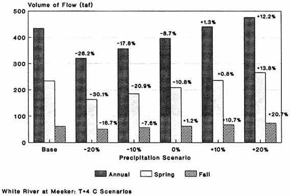
FIGURE 9.1 Effect of hypothetical changes in precipitation on streamflow in the White River.
very high in these basins, significant increases in runoff would increase the risk of flooding.
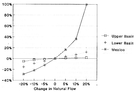
CRSS Model Results
Changes in natural flow produce uneven changes in actual (modeled) flow (Figure 9.3). For example, increases in natural flow have a relatively greater effect on actual flow at the compact point (the dividing point between the upper and lower Colorado River basins, which occurs at Lee's Ferry) than do corresponding decreases in natural flow. This reflects the fact that under conditions of decreased flow, reservoir releases are being increased. Accordingly, a 10 percent decrease in natural flow produces a 30 percent decrease in upper basin storage and only a 12 percent decrease in flow at the compact point. A similar effect can be seen for actual flow below Imperial Dam, where a 10 percent increase in natural flow produces an 11 percent increase in actual flow, whereas a 10 percent increase in natural flow results in only a 7 percent decrease. At an upstream point—
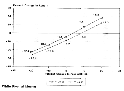
FIGURE 9.2 Mean annual, spring (April through June), and fall (October through December) flows for the White River. The base case and the T+4°C scenarios are shown. Percentage numbers indicate the change in flow compared to the base case.
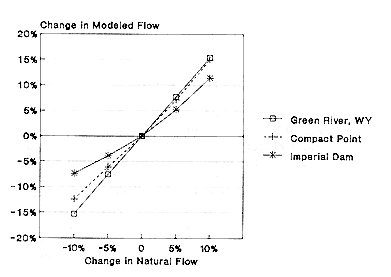
FIGURE 9.3 Effect of changes in natural flow on changes in actual flow at three stations.
Green River at Green River, Wyoming—these discrepancies are not discernable. A 10 percent change in natural flow (equivalent to an absolute change of 150 trillion acre-feet [taf]) in either direction causes a 15 percent change in actual flow (also equivalent to 150 taf).
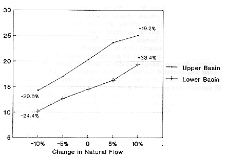
The impact of changes in natural flow on storage can be seen in Figure 9.4. When natural flow is increased by 10 percent, storage in the upper basin increases by 19 percent, to roughly 85 percent of total capacity. Storage changes rapidly because the reservoir system is designed and operated for historic flow conditions. The buffering capacity of the current system is relatively ineffective in the face of 10 percent changes in flow over the long term.
Hydroelectric power production is also strongly affected by relatively moderate changes in flow. A 5 percent decrease in natural flow corresponds to a 4 to 8 percent decrease in actual flow but results in a 15 percent decrease in hydropower production. A 10 percent increase in natural flow creates a 10 to 15 percent increase in actual flow and a 20 percent increase in annual average hydropower production.
The impact of changes in natural flow on depletions (consumptive use) is shown in Figure 9.5. Overall deliveries and depletions do not decline as much as decreases in flow might suggest, because reservoir storage is being dramatically reduced so water-supply requirements can be met. The minus 20 percent scenario causes an 11 percent decline in average annual consumptive use, while the plus 20 percent scenario causes an 8 percent rise in average annual consumptive use. It is difficult to assess the relative impacts of extreme shortages on different users because allocations and operating procedures would be subject to many political, technical, and economic variables. In the CRSS model, shortages are allocated based on the assumption that they would not ultimately exceed those that occurred during the most critical period on record (1953 through 1964). Consequently, the model imposes reductions in the upper basin that equal only about 5 percent of total demand. Additional shortages are then passed on to the lower basin. Using this shortage strategy, upper and lower basin depletions decline by 2 and 9 percent, respectively, in the minus 10 percent scenario. Compact requirements were violated 33 percent of the time under the minus 5 percent scenario and 61 percent of the time under the minus 20 percent scenario.
It must be emphasized, however, that this shortage strategy results in an unlikely apportionment of river flows. In fact, legally, the upper basin should suffer relatively greater shortages than the lower basin (Getches, 1991, pp. 15-16). Under a strict interpretation of the Colorado River Compact, upper basin consumption could be limited
to 3 maf or less roughly one-third of the time even under the base-case scenario. This would be a cutback of more than 20 percent over current levels. Under the minus 20 percent scenario, the upper basin might never receive more than 3 maf per year and could receive as little as 2 maf in about 10 percent of the years.
Not surprisingly, the greatest vulnerability of the system is in the area of water quality (salinity). Under almost no circumstances can existing water-quality standards be met given projected demands and operating constraints. Our results suggest that at least a 20 percent increase in natural flow would be needed to bring the salinity levels in the lower basin into compliance with existing standards (Figure 9.6). Although the scenarios presented here result in only moderate changes in salinity, the problem is already so severe in the base case that even moderate declines in water quality are of particular concern.
DISCUSSION AND CONCLUSIONS
In the first study to analyze the impacts of climatic change on the Colorado River, Stockton and Boggess (1979) used Langbein's relationships (Langbein et al., 1949) to estimate the effects of a 2°C temperature rise and a 10 percent decrease in precipitation. They found that streamflow in the upper basin would decline by about 44 percent. Following up on that work, Revelle and Waggoner (1983) developed a linear regression model of runoff using precipitation and temperature as independent variables. Their model predicted that a 2°C temperature increase would decrease mean annual flow by 29 percent, while a 10 percent decrease in precipitation would decrease runoff by about 11 percent. In combination, these changes would result in a 40 percent decrease in runoff, in close agreement with Stockton and Boggess's earlier result.
In contrast, our studies with the NWSRFS model suggest less severe impacts on runoff and a greater sensitivity of annual runoff to precipitation rather than temperature changes. A 2°C temperature rise combined with a decrease in precipitation of 10 percent would decrease runoff by 14 to 23 percent. While these results are lower than results of the earlier statistical studies, they still represent dramatic decreases in water availability in the Colorado basin. These results are comparable to similar studies of arid and semi-arid basins that used conceptual hydrologic models (Gleick, 1987; Flaschka et al., 1987), supporting Karl and Riebsame's (1989) conclusion that the Langbein relationships overstate the role of evaporation. For the
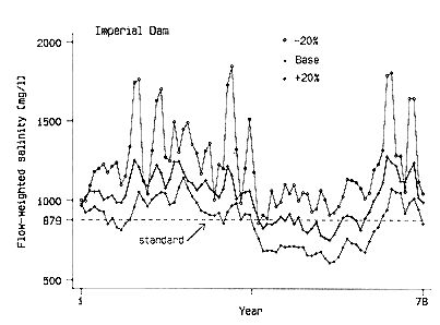
FIGURE 9.6 Salinity as a function of year at Imperial Dam. The base case and the +20 percent scenarios are shown. Water-quality standards are continually violated in all but the +20 percent scenario.
range of scenarios presented here, mean annual runoff changes nearly linearly with precipitation, although this relationship begins to break down as precipitation increases by 20 percent, at which point runoff begins to increase more quickly.
Our analysis suggests that variations in mean annual runoff of 30 percent are possible as a result of climatic change, with even greater changes likely in the most arid subbasins, but that precipitation changes of more than 10 percent would be necessary before changes in annual runoff would be significantly different from the historic flow series (Nash and Gleick, 1991). This does not imply that the impacts of climatic change are insignificant, but it does suggest the difficulty inherent in detecting the effects of climatic change given a relatively short and variable streamflow record. The results also suggest that increases in precipitation would be needed to balance the effects of higher temperatures on runoff. If precipitation stays the same or decreases, substantial decreases in water availability may result.
An increase in temperature shifts the seasonality of runoff as well, with peak runoff occurring earlier in the spring. This change reflects the fact that under higher temperatures, more precipitation falls as rain rather than snow, and snowmelt runoff occurs earlier in the year. Because this seasonal result is induced by changes in temperature, rather than by less-certain changes in precipitation, we believe it is fairly robust.
Table 9.6 summarizes the sensitivity of several water supply variables to changes in natural flow. Looking back at the hydrologic modeling discussed above, we can relate climate scenarios to changes in water supply. A temperature increase of 2°C and a decrease in precipitation of 10 to 20 percent corresponds, more or less, to a decrease in runoff of 20 percent. This, in turn, would cause reductions in storage of 60 to 70 percent, reductions in power generation of 60 percent, and an increase in salinity of 15 to 20 percent. A temperature increase of 2°C accompanied by an increase in precipitation of 20 percent corresponds roughly to a 20 percent increase in runoff, a 30 to 60 percent increase in storage, a 40 percent increase in power production, and a 13 to 15 percent decrease in salinity. A temperature increase of 4°C coupled with a precipitation decrease of 20 percent would result in approximately a 30 percent decrease in runoff, which is more extreme than any of the scenarios modeled with the CRSS.
The magnitude of these changes suggests that the Colorado basin would be highly vulnerable to the level of climatic changes contemplated in this study. Without any change in precipitation, these temperature changes alone imply decreases in runoff of 5 to 10 percent. The water supply impacts of such a change would be severely felt throughout the basin. The upper basin is likely to suffer given current institutional arrangements, but the lower basin will not be immune either because of its heavy (and increasing) dependence on Colorado River water. Although the Law of the River places the burden of shortages on the upper basin, the volume of lower basin demands, combined with the high priority given to supplying them on an annual basis, removes water management flexibility. Moreover, decreases in flow would exacerbate an already severe salinity problem in the lower basin. Should precipitation increase, some or all of these impacts might be offset, but should precipitation decrease, the impacts may exceed even those presented here.
It should be borne in mind, however, that these results reflect flow changes of 5 to 20 percent imposed on the hydrology of the last 80 years. The results would be different if a different hydrologic record had been used. For instance, the hydrology of the last 400
TABLE 9.6 Sensitivity of water-supply variables to changes in natural flow in the Colorado River Basin.1
years suggests that much more severe and sustained droughts have occurred in the past. If this hydrology were used as a basis for a similar study, decreases in flow would have still greater impacts on the basin.
In summary, this research points out that significant changes in streamflow are likely if scenarios of future climatic changes prove to be accurate. Most hydrologic records are quite short and have been subject to other complicating effects (e.g., dams, diversions, and changes in vegetative water use). Thus, changes in annual runoff may not be distinguishable from natural variability until mean runoff has changed by more than 10 percent. This suggests that prudent management policies should not wait for verifiable change. While the Colorado basin is prepared to handle very large short-term fluctuations in streamflow, it may nonetheless be vulnerable to long-term increases or decreases in streamflow and water supply.
REFERENCES
Anderson, E. A. 1973. National Weather Service River Forecast System: Snow Accumulation and Ablation Model. National Oceanic and Atmospheric Administration Technical Memorandum NWS HYDRO-17. Silver Spring, Md.: U.S. Department of Commerce.
Burnash, R. J., R. L. Ferral, and R. A. McGuire. 1974. A Generalized Streamflow Simulation System: Conceptual Modeling for Digital Computers. Sacramento, Calif.: Joint Federal-State River Forecast Center.
Flaschka, I. M., C. W. Stockton, and W. R. Boggess. 1987. Climatic variation and surface water resources in the great basin region. Water Resources Bulletin 3:47-57.
Getches, D. H. 1991. Water Allocation During Drought in Arizona and Southern California: Legal and Institutional Responses. Boulder, Colo.: University of Colorado Natural Resources Law Center.
Gleick, P. H. 1987. Regional hydrologic consequences of increases in atmospheric CO2 and other trace gases. Climatic Change 10:137-161.
Karl, T. R., and W. E. Riebsame. 1989. The impact of decadal fluctuations in mean precipitation. Climatic Change 15:423-448.
Klemes, V. 1985. Sensitivity of Water Resource Systems to Climate Variations. World Climate Applications Programme WCP-98. Geneva: World Meteorological Organization.
Langbein, W. B., et al. 1949. Annual Runoff in the United States. U.S. Geological Survey Circular 5. Washington, D.C.: U.S. Department of the Interior.
Nash, L. L., and P. H. Gleick. 1991. The sensitivity of streamflow in the Colorado basin to climatic changes. Journal of Hydrology 125:221-241.
Nemec, J., and J. Schaake. 1982. Sensitivity of water resource systems to climate variation. Hydrological Sciences 27:327-343.
Revelle, R. R., and P. E. Waggoner. 1983. Effects of a carbon dioxide-induced climatic change on water supplies in the western United States. Pp. 419-432 in Changing Climate. Washington, D.C.: National Academy Press.
Stockton, C. W., and W. R. Boggess. 1979. Geohydrological Implications of Climate Change on Water Resource Development. Fort Belvoir, Va.: U.S. Army Coastal Engineering Research Center.
U.S. Department of the Interior (DOI). 1987. Colorado River Simulation System: System Overview. Denver, Colo.: U.S. Department of the Interior.


