
7
Regionalization
INTRODUCTION
Regional variation among wetlands affects the validity and usefulness of nationwide procedures for delineation. Not only wetlands, but also the upland ecosystems with which they interface, are regionally variable. This variation accounts for much of the difficulty in developing reliable procedures and indicators that can be used to establish wetland boundaries in all parts of the United States.
Gallant et al. (1989) define a region as an area that is to a certain extent homogeneous with respect to specific characteristics of interest for a particular purpose. Regionalization is ''a method of reducing or eliminating details which do not, on the average, hold true over large areas'' (Wiken, 1986). Regionalization for the purpose of wetland delineation, therefore, would require the identification of areas with some degree of homogeneity in wetland characteristics and the development of specific regional procedures or indicators.
A regionalized delineation approach involves several steps. First, regional boundaries must be circumscribed around an area with unifying properties. Second, the occurrence and fidelity of wetland indicators within that region must be determined. Finally, a regionally valid system must be adopted for applying indicators to wetland determinations. Regionalization thus extends beyond mere division of a national list of indicators into subsets (such as state lists) because true regionalization involves the regional adaptation of indicators and delineation methods.
Current wetland delineation methodologies already incorporate some re-
gional elements. For example, regional hydrophyte and hydric soil lists supplement the broad national criteria and indicators for identification and delineation of wetlands. Regional offices for each of the four federal agencies that deal extensively with wetlands, i.e., U.S. Army Corps of Engineers (USACE), National Resources Conservation Service (NRCS), U.S. Fish and Wildlife Service (FWS), and U.S. Environmental Protection Agency (EPA) consider regional conditions as they identify and delineate wetlands. This chapter contains an evaluation of the ways in which wetland delineation is currently regionalized as well as the potential for increasing its regionalization.
HIERARCHY OF REGIONAL VARIATION
Wetlands, which occur at every latitude from the equator to the arctic, vary in precipitation, evapotranspiration, temperature, and insolation. Wetland hydrology, substrates, and biota reflect this climatic variation. Land forms also can be a cause of variation because of their relationship to regional geomorphology associated with such factors as glaciation and change in sea level. In addition, the composition and stratigraphy of underlying geologic deposits vary regionally and strongly influence wetland formation and characteristics. Wetland size, configuration, and hydrology are greatly influenced by climatic and geomorphic factors (Johnston, 1982; Winter, 1992; Brinson, 1993a).
Variation of wetlands occurs over a hierarchy of scale from continental to sites within a wetland (Table 7.1). The principal type of variation at the continental scale is physiographic regions as a result of climate, especially as it reflects temperature and precipitation. The balance between precipitation and evapotranspiration rates greatly influences the prevalence of wetlands in the landscape and the duration of inundation. Because variation in growing season occurs at this scale, many of the difficulties associated with the application of numeric
TABLE 7.1 Scales, Types, and Cause of Variation at Scales Arranged from Coarsest to Finest (Causes of Variation at Large Scales May Also Affect Smaller Scales)
|
Scale of Variation |
Characteristic Type of Variation |
Cause of Variation |
|
Continental (U.S.) |
Among physiographic regions |
Climate |
|
Physiographic region |
Among wetland classes |
Geomorphic setting, water sources, hydrodynamics |
|
Wetland class |
Size and connections to upland, aquatic, and other wetlands |
Hydroperiod, soils, plant assemblages |
|
Intra-wetland |
Topographic position |
Plant species composition, hydrologic status, redoximorphic features |
thresholds (days of continuous saturation) could be minimized by regionalization at the continental scale. Appropriate regional boundaries for wetlands would divide some large states and cluster other small states. Many wetland delineators feel comfortable working within a region because it matches the geographic extent of their expertise in wetland flora and soils.
Variation occurs also within physiographic regions (Table 7.1). A given region may have all classes of wetlands which will differ substantially from one another in geomorphic setting, water sources, and hydrodynamics. For example, bogs, tidal marshes, and freshwater swamps can all be found within a single region. Classes often cluster, however, as mountainous areas tend to support riparian wetlands, whereas glaciated plains are rich in depressional wetlands.
Within a wetland class, variation is found in size and the connection of individual wetlands to other landscape units, including other wetlands that occur in vast wetland complexes. These connections influence functionally important processes such as the capacity for nutrient removal or the quality of habitat for estuarine dependent fish. Variation will be found in hydroperiod, soils, and plant assemblages.
The smallest scale relevant to characterization of wetlands is the intra-wetland scale. Topographic position within the wetland along the wetness gradient accounts for variation at this scale. Combinations of plant species, inundation and saturation, and redoximorphic soil features as they occur along the wetland to upland continuum, make this scale of variation the major focus of wetland delineation. Given the amount of variation at scales larger than that within a single wetland (Table 7.1), however, it is clear that excessive focus on individual sites could lead to the development of delineation systems that fail to account for variation at larger scales.
Regional Variation in Hydrology
Hydrologists have long recognized that the discharge characteristics of a stream are related to the size of its watershed. The hierarchical ordering of streams from the smallest rills in headwater reaches (first order) to rivers of continental scale (greater than sixth order) reflects the relationship of hydrology to scale (Leopold et al., 1964). Groundwater also can be divided into flow systems at local to regional scales (Toth, 1963; Freeze and Cherry, 1979). Groundwater flow systems of local scale have short subsurface flow paths recharged by infiltration on local uplands. These flow paths terminate in adjacent lowlands where the groundwater moves either to the water table or to surface waters. There is also some degree of water loss by evaporation and evapotranspiration.
Unlike local ground water flows, flow systems of intermediate scale (0.6 mi to tens of miles [1 km to tens of km]) have subsurface flow paths that bypass adjacent lowlands. Flow systems of regional scale have even longer flow paths
(6 mi to hundreds of miles [10 km to several hundred kilometers]) that discharge to major rivers and lakes.
Lakes, wetlands, and groundwater interact at a range of scales (Siegel, 1988; Winter, 1992). For example, Siegel and Glaser (1987) have shown that seasonal changes in the amount of groundwater reaching bogs in northern Minnesota is probably related to changes in the height of the water table on beach ridges located many miles away.
Regional contrasts in the groundwater hydrology of wetlands are very large. For example, in the humid northcentral and northeastern states, wetlands in surface depressions are usually located over groundwater discharge areas—where the direction of groundwater flow is upward (McNamara et al., 1992). In contrast, wetlands in the drier parts of the West often conduct water downward, thus causing local elevation of the underlying water table. Examples include prairie pothole wetlands in the northcentral states (Appendix B). Other wetlands, in-eluding some prairie pothole wetlands, recharge groundwater during wet weather but receive groundwater during dry weather (Winter, 1989).
In humid and dry regions alike, wetlands can be perched above and isolated from the regional water table wherever wetland soils do not drain efficiently. Isolation of wetlands from the regional groundwater table particularly occurs where hydrology has been altered by control structures and artificial drainage, as is the case on the Mississippi River Delta. The inundation and saturation of riparian wetlands and wetlands near the ocean or large lakes is mostly controlled by fluctuations in the water levels of the adjacent body of water.
Regional Variation of Soils
Climate, topography, and parent material (the geologic substratum from which a soil is derived) are three of the major soil-forming factors upon which classification of soils is based (Jenny, 1941). The proportion of hydric soils is highest for areas with relatively flat topography, glacial or coastal plain geomorphology, and high summer rainfall. In fact, climatic terms are used in the U.S. system of soil taxonomy to describe soil moisture (aquic, aridic, torric, udic, ustic, xeric) and temperature (pergelic, cryic, frigid, mesic, thermtic, hyperthermic) (Soil Survey Staff, 1975). Because moisture and temperature are components of climate, soil nomenclature is inherently regional. Most wetland soils, however, fall within the aquic moisture regime, which reduces their climatic differentiation under soil taxonomy to temperature regimes only. Also, fewer regional distinctions are made in the mapping of wetland soils than in the mapping of upland soils because wetland soils are usually mapped in less detail. Many soil surveys use generic terms to classify wetlands (marsh, playa), or assign them to general soil series that occur in more than one state.
Regional Variation of Plants
A number of plant characteristics vary regionally. Plant life form is one of the most obvious of these. For example, forested wetlands dominate in the eastern U.S. (Shaw and Fredine, 1956), whereas nonwoody vegetation dominates wetlands in drier regions, such as the prairie pothole area. Growing seasons for plants differ substantially among regions, and plant phenology reflects the correlated regional variation in light and temperature (Chapter 5). Plants also are adapted to regional differences in soil chemistry related to geomorphology, physiography, and climate (high sediment loads in riverine wetlands or high salt content in wetlands of arid and semiarid zones).
Wetland vegetation consists of at least two groups of plants: those that require soil saturation to become established or to persist and those that tolerate it. Plants that are not found in wetlands are intolerant of the stresses associated with wetland edaphic conditions. As explained in Chapter 5, anaerobic conditions are the most common source of stress accounting for the absence of upland plants. Indicators that account only for the tolerance of wetland plants and the intolerance of upland plants are suitable for many regions and wetland types. For some wetland types in some regions, however, species composition reflects a requirement for wetness rather than a tolerance of anaerobic conditions. For example, in the upper salt marshes of California, plants such as Salicornia subterminalis (an obligate [OBL] wetland species), Monanthochloe littoralis (OBL), and Atriplex watsonii (a facultative wetland [FACW] species) become established because of their winter moisture requirements, even though inundation is rare (Nixon, 1982) and soils are oxygenated (Zedler, 1982; Callaway et al., 1990; Pennings and Callaway, 1992). Similarly, most wetland animals (aquatic invertebrates, fish) occur in wetlands because of their requirement for water rather than because of their tolerance of it.
A wetland plant species might require soil saturation for germination and establishment, yet be relatively intolerant of inundation as an adult. Such species are most likely to occur where water levels fluctuate widely, especially where rainfall, runoff, and standing water are episodic and unpredictable, as in the western United States. An example is Salicornia virginica, a salt marsh dominant species that is restricted to midintertidal areas because of its high moisture requirements for establishment, but that dies if the canopy is inundated (Zedler et al., 1992). Black cottonwood is considered a wetland species by current researchers, because it depends on the action of water to establish on unvegetated mineral soil. The seeds of this species germinate in sandy soils within two days after flood waters recede, and roots grow at a rate of 1 cm/day for about 40 days thereafter (personal communication, 1994, R. Stettler, University of Washington). Other cotton wood species have similar characteristics (Friedman, 1993). Cottonwood persists even when sedimentation rates are high because it can produce adventitious roots, thus adapting to burial of the root crown. In contrast,
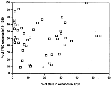
FIGURE 7.1 Comparison of wetlands in 1780 to wetlands in 1980 for all of the United States. Source: Dahl, 1990.
alder (Alnus rubra), a faculative (FAC) species often found in uplands, does not release seed coincident with spring flooding, nor do its seedlings produce adventitious roots.
Regional Variation in Abundance of Wetlands
Differences in geomorphology and climate were the cause of variation in wetland abundance among the states before to extensive European. settlement. Use of the land resulted in a greater reduction of wetland area in some states than in others, however (Figure 7.1). In this way, anthropogenic influences have magnified natural variations in abundance of wetlands.
With scarcity, resources become more valuable, particularly if they perform a unique function, as does an oasis in a desert. With scarcity of wetland resources comes greater dependence of biota on wetlands for water and food, greater vulnerability of species when a wetland or unit of wetland area is lost, greater public
concern over wetland loss, and greater need to protect the appropriate distribution of wetland patches that can sustain biodiversity.
REGIONALIZATION SCHEMES
Regional Classification Systems
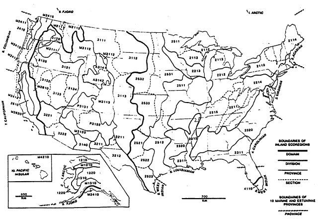
The wetland classification system of Cowardin et al. (1979) acknowledges the importance of regionalization and incorporates Bailey's (1976) ecoregion map, which it modifies by the addition of 10 marine and estuarine provinces for North America (Figure 7.2). These regions, which do not appear on the National Wetland Inventory maps, are apparently unused at present.
Several classification systems are specific to particular regions. For example, Stewart and Kantrud (1971) devised a classification system specific to the glaciated prairie pothole region, an area of substantial interannual variability in wetness (Appendix B, prairie pothole case study). This classification system was introduced as a regional alternative to the FWS classification system in use at the time (Shaw and Fredine, 1956) (Chapter 3). In addition to seven types of prairie pothole wetlands, it contains six salinity classes and five hydrologic phases to account for long-term variation in hydrology, and it includes agriculture as a cause of variation. For the glaciated northeast, Golet and Larson (1974) classify freshwater wetland types on the basis of differences in plant life forms. Golet was later a coauthor of the work by Cowardin et al. (1979), which uses a life form approach to classifying wetlands (tree, shrub/scrub, emergent, moss/lichen). Among others, regional wetland classification systems have been developed for Alaska (Schempf, 1992), the southern U.S. (Penfound, 1952; Clark and Benforado, 1981), Ontario (Jeglum et al., 1974), and California (Ferren et al., 1994).
There have been some attempts to classify wetlands regionally according to geologic and hydrologic factors. Novitzki (1979) relates Wisconsin wetlands to water source and landform, Thompson et al. (1992) classifies Iowa fens according to their geologic setting, and Hollands (1987) classifies wetlands in glaciated regions by hydrology and vegetation.
Reports on regional wetland types have been commissioned by FWS, USACE, and EPA. Appendix A of the 1989 interagency manual lists several studies, including a series of "Community Profile" reports that synthesize the literature for a variety of wetland types. These studies provide information about basic wetland ecology that is essential to regionalization, but they generally focus on wetland interiors rather than boundaries. Other relevant regional report series include the FWS Soil-Vegetation Correlation reports (Chapter 5), Preliminary Guides prepared by the USACE (1978a,b,c,d,e; Huffman et al., 1982a,b; Huffman and Tucker, 1984) and transition zone studies commissioned by USACE (Johnson et al., 1982a; Fletcher, 1983).
Several climatic and physiographic schemes could serve as an ecological basis for regionalization. A modified version of Bailey's (1976) ecoregion map is proposed by Cowardin et al. (1979) for this purpose (Figure 7.2). A similar scheme is found in Omernik (1987), who divides the conterminous United States into 76 ecoregions based on land use, land surface form, potential natural vegetation, and soils (Figure 7.3). This scheme has been applied successfully in studies of water quality and fish distribution. Unfortunately, the Omernik system does not include Alaska, Hawaii, or U.S. possessions.
The U.S. Department of Agriculture has divided the country into 27 land resource regions based on physiography and crop potential. Statistically distinct intrastate map units are identified by sampling that was done for the Soil Conservation Service 1982 National Resource Inventory (Lytle, 1993). By acknowledging the influence of human activity, these subdivisions could more accurately portray current wetland status than do schemes based mainly on natural vegetation (Bailey, 1976; Omernik, 1987).
Several approaches could be used to regionalize wetlands on the basis of hydrology. The U.S. Geological Survey has divided the nation into hydrologic units consisting of watersheds for major rivers and coastal regions. This system has been used since 1977 for the National Stream Quality Accounting Network (Briggs and Ficke, 1977), and it is widely used for a variety of other surface water applications. EPA has developed a national "reach file," which divides rivers and streams into segments for which water quality data are collected and summarized. The U.S. Geological Survey and EPA systems would apply to wetlands that occur adjacent to rivers and streams, but would be less applicable to wetlands that receive primarily ground water or runoff.
Brinson (1993a) developed a hydrogeomorphic classification based on geomorphic setting, water source, and hydrodynamics (Table 7.2). A wetland's geomorphic setting is typically related to its capacity to store water and the pattern of water flow. Wetlands range regionally from bogs largely maintained by precipitation to tidal marshes inundated by seawater. In addition, the motion of water (hydrodynamics) can be used to distinguish among wetlands.
Winter (1992) identifies 8 basic physiographic settings in which wetlands form. By combining the physiographic settings with the climatic settings in which each occurs, he identifies 24 type settings for long-term wetlands research (Table 7.3). The wetland type settings are not "regional types" but are analagous to the species type concept. Winter recognizes that almost all wetlands are located where water becomes focused at breaks in the gradient of the water table, either because of depressions in the surface topography or because of changes in hydrogeologic conditions, such as permeability (Winter, 1992). He also recognizes that long-term hydrologic features are related to regional climate.
|
1000 Polar |
2000 Humid Temperate |
3000 Dry |
|||||||||
|
|
1200 Tundra |
|
2400 Marine |
|
3100 Steppe |
||||||
|
|
|
1210 Arctic Tundra |
|
|
2410 Willamette-Puget Forest |
|
|
M3110 Rocky Mountain Forest |
|||
|
|
|
1220 Bering Tundra |
|
|
M2410 Pacific Forest (in conterminous U.S.) |
|
|
|
M3111 Grand fir-Douglas-fir Forest |
||
|
|
|
M1210 Brooks Range |
|
|
|
M2411 Sitka Spruce-Cedar-Hemlock Forest |
|
|
|
M3112 Douglas-fir Forest |
|
|
|
1300 Subarctic |
|
|
|
M2412 Redwood Forest |
|
|
|
M3113 Ponderosa Pine-Douglas-fir Forest |
||
|
|
|
1320 Yukon Forest |
|
|
|
M2413 Cedar-Hernlock-Douglas-fir Forest |
|
|
|
3120 Palouse Grassland |
|
|
|
|
M1310 Alaska Range |
|
|
|
M2414 California Mixed Evergreen Forest |
|
|
M3120 Upper Gila Mountains Forest |
||
|
2000 Humid Temperate |
|
|
|
M2415 Silver fir-Douglas-fir Forest |
|
|
3130 Intermountain Sagebrush |
||||
|
|
2100 Warm Continental |
|
|
M2410 Pacific Forest (in Alaska) |
|
|
|
3131 Sagebrush-Wheatgrass |
|||
|
|
|
2110 Laurentian Mixed Forest |
|
|
|
|
|
|
|
3132 Lahontan Saltbush-Greasewood |
|
|
|
|
|
2111 Spruce-Fir Forest |
|
2500 Prairie |
|
|
|
3133 Greet Basin Sagebrush |
||
|
|
|
|
2112 Northern Hardwoods-Fir Forest |
|
|
2510 Prairie Parkland |
|
|
|
3134 Bonneville Saltbush-Greasewood |
|
|
|
|
|
2113 Northern Hardwoods Forest |
|
|
|
2511 Oak-Hickory-Bluestem Parkland |
|
|
|
3135 Poudeross Shrub Forest |
|
|
|
|
2114 Northern Hardwoods-Spruce Forest |
|
|
|
2512 Oak + Bluestem Parkland |
|
|
P3130 Colorado Plateau |
|
|
|
|
M2110 Columbia Forest |
|
|
2520 Prairie Brushland |
|
|
|
P3131 Juniper-Pinyon Woodland + Sagebrush Saltbush Mosaic |
||
|
|
|
|
M2111 Douglas-fir Forest |
|
|
|
2521 Mesquite-Buffalo Grass |
|
|
|
|
|
|
|
|
M2112 (Cedar-Hemlock-Douglas-fir Forest |
|
|
|
2522 Juniper-Oak-Mesquite |
|
|
|
P3132 Grama-Galleta Steppe + Juniper-Pinyon Woodland Mosaic |
|
|
2200 Hot Continental |
|
|
|
2523 Mesquite-Acacia |
|
|
|
|
||
|
|
|
2210 Eastern Deciduous Forest |
|
|
2530 Tall-Grass Prairie |
|
|
3140 Mexican Highland Shrub Steppe |
|||
|
|
|
|
2211 Mixed Mesophytic Forest |
|
|
|
2531 Bluestem Prairie |
|
|
A3140 Wyoming Basin |
|
|
|
|
|
2212 Beech-Maple Forest |
|
|
|
2532 Wheatgrass-Bluestem-Needlegrass |
|
|
|
A3141 Wheatgrass-Needlegrass-Sagebrush |
|
|
|
|
2213 Maple-Basswood Forest + Oak Savanna |
|
|
|
2533 Bluestem-Grama Prairie |
|
|
|
A3142 Sagebrush-Wheatgrass |
|
|
|
|
2214 Appalachian Oak Forest |
|
|
2600 Mediterranean (Dry-summer Subtropical) |
|
3200 Desret |
|||
|
|
|
|
2215 Oak-Hickory Forest |
|
|
|
2610 California Grassland |
|
|
3210 Chihuahuan Desert |
|
|
|
2300 Sabtropical |
|
|
|
M2610 Sierran Forest |
|
|
|
3211 Grama-Tobosa |
||
|
|
|
2310 Outer Coastal Plain Forest |
|
|
|
M2620 California Chapearral |
|
|
|
3212 Tarbush-Creosote Bush |
|
|
|
|
|
2311 Beech-Swestgum-Margnolia-Pine-Oak |
|
3000 Dry |
|
|
3220 American Desert |
|||
|
|
|
|
2312 Southern Floodplain Forest |
|
|
3100 Steppe |
|
|
|
3221 Creosote Bush |
|
|
|
|
2320 Southeastern Mixed Forest |
|
|
|
3110 Greet Plains-Shortgrass Prairie |
|
|
|
3222 Creosote Bush-Bur Sage |
|
|
|
|
|
|
|
|
|
3111 Grama-Needlegrass-Wheatgrass |
4000 Humid Tropical |
|||
|
|
|
|
|
|
|
|
3112 Wheatgrass-Needlegrass |
|
4100 Savanna |
||
|
|
|
|
|
|
|
|
3113 Grama-Buffalo Grass |
|
|
4110 Everglades |
|
|
|
|
|
|
|
|
|
|
|
4200 Rainforest |
||
|
|
|
|
|
|
|
|
|
|
|
M4210 Hawaiian Islands |
|
FIGURE 7.2 Ecoregions of the United States after Bailey (1976) with the addition of 10 marine and estuarine provinces. Source: Cowardin et al., 1979.
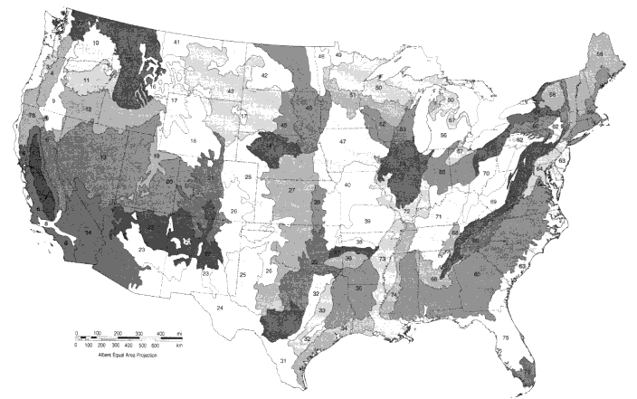
TABLE 7.2 Hydrogeomorphic Classes of Wetlands Based on Geomorphic Setting, Water Source, and Hydrodynamics (Brinson, 1993a)
|
Geomorphic setting |
Principal Water Sources |
Hydrodynamics |
Example |
|
Riverine, floodplain |
Overbank, ground water discharge, overland flow |
Unidirectional, horizontal |
Bottomland hardwood forest |
|
Depression |
Precipitation, ground water discharge, overland flow |
Vertical |
Prairie pothole, Carolina bay |
|
Slope |
Ground water discharge |
Unidirectional, horizontal |
Minnesota fen |
|
Peatland |
Precipitation |
Vertical |
Bog, pocosin peatland |
|
Flat |
Precipitation |
Vertical |
Wet pine savanna, winter wet woods |
|
Lacustrine fringe |
Seichesa |
Bidirectional, horizontal |
Great Lakes marsh |
|
Estuarine fringe |
Lunar tides |
Bidirectional, horizontal |
Coastal salt marsh |
|
a Harmonic water level fluctuations in large lakes resulting from wind relaxation after a period of setup. |
|||
CURRENT APPROACHES
Regionalization of Federal Agencies
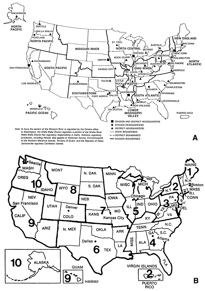
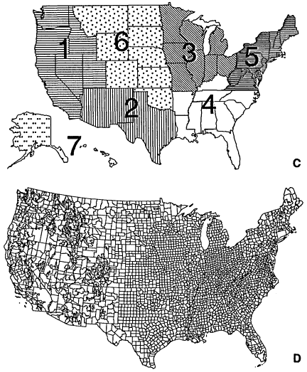
The four federal agencies involved in wetland delineation are regionalized administratively, although their regional boundaries do not coincide (Figure 7.4). FWS has the fewest regions (seven), and NRCS has the most (virtually every county and parish in the United States is an NRCS district). Administration of the Clean Water Act Section 404 program by USACE is distributed among 36 districts plus 2 divisions that do not contain districts (Pacific Ocean Division, New England Division). USACE districts are generally bounded by major watershed divides, and are named for the city in which the district office is located. FWS and EPA regions are groups of states (Figure 7.4). NRCS regionalization is the most elaborate and hierarchical: At the county level are district offices, several counties are coordinated by an area office, the area offices are coordinated by a state office, and the state offices report to the national chief of NRCS.
The differences among agencies in regionalization complicate delineation of wetlands because a regional office might need to coordinate not only with other federal agencies, but also with the various regional offices of several agencies. This complexity will increase as NRCS, the most subdivided of the agencies, assumes its new lead role in classification of agricultural wetlands (Chapters 4 and 6).
TABLE 7.3 A Classification System for Wetland Hydrology Based on Climate and Physiography
|
Physiography |
Climate |
Region |
Statesa |
|
Terrace and scarp with coastal lowland, including tidal |
Warm, dry |
South Atlantic Coast |
NC, SC, VA, MO |
|
|
Warm, wet |
Gulf Coast |
LA, MS, FL |
|
|
Cold, dry |
Northern Minnesota |
MN |
|
Terrace within riverine valley including adjacent upland and river |
Cold, wet |
Northern Appalachian valleys |
New England |
|
|
Warm, wet |
Southern Appalachian valleys |
TN, GA |
|
|
Cold |
Northern Mississippi valley |
MN, WI |
|
|
Warm |
Southern Mississippi valley |
AR, LA, MS |
|
|
Wet |
Eastern tributary of Mississippi River (e.g., Ohio River valley) |
KY, OH, IN |
|
|
Dry |
Western tributary of Mississippi River (e.g., Missouri River valley) |
ND, SD, NE, OK, TX |
|
Steep slope adjacent to narrow lowland |
Cold, wet |
North Appalachian uplands |
NY, New England |
|
|
Warm, wet |
South Appalachia uplands |
GA, TN |
|
|
Cold, dry |
Rocky Mountains |
CO, WY, MT, ID, |
|
|
Cold, wet |
Sierras, Cascades |
CA, OR, WA |
|
Depression in large, extensive lowland |
Cold, dry |
North playas |
NV |
|
|
Warm, dry |
South playas |
AZ, NM |
|
Morainal depression |
Cold, wet |
East northcentral United States |
WI, MI |
|
|
Cold, dry |
West northcentral United States |
ND, SD |
|
|
Cold, wet |
Puget lowland |
WA |
|
Dune field |
Cold, wet |
East central United States |
IN, MI |
|
|
Cold, dry |
West central United States |
NE, WY |
|
|
Cold, wet |
West Coast |
OR, WA |
|
Sink hole |
Warm, wet |
Southwestern United States |
FL |
|
Other depression |
Warm, dry |
Southeastern United States |
TX |
|
Permafrost |
Cold, dry |
Northern Alaska |
AK |
|
a The geographic regions and states in table are not all inclusive of the physiographic type but only indicate where the type is well developed. Source: Modified from Winter, 1992. Reprinted with the permission of the National Hydrological Research Institute, Environment Canada. |
|||
The USACE district office is usually the primary point of contact for Section 404 permits. Although all USACE districts use the same manual, there are minor differences among the districts in its implementation. Consultants who perform wetland delineations become accustomed to the standards of a district through their interactions with the staff in the district office, and can adjust their delineations accordingly. Organizational regionalization is not an ecological source of variation, but it is likely to cause some regional variation in wetland delineation.
Regional Lists of Hydrophytes and Soils
Regionalization is invoked in two ways through current delineation methodologies: first, through the use of regional hydrophyte and state hydric soils lists and second, through the use of growing season, which varies regionally, in the application of soil saturation thresholds. The Hydrophyte List (Chapter 5) is divided into 13 regional lists (Figure 7.5). The 13 regions are assemblages of adjacent states or portions thereof. NRCS has developed from the national Hydric Soils List (Chapter 5) local lists of map units that contain hydric soils for each county or parish in the United States. These local lists contain details about soil categories within series (''phases'' and "types" within a series) and map units that contain mixed soil series (a complex of hydric and nonhydric soils).
Regional panels were not established for soils as they were for hydrophytes, but the Hydric Soils List (USDA, 1991) was reviewed by NRCS state offices (Chapter 5). State soil scientists also have some latitude to modify the national criteria as necessary to develop state hydric soils lists, and they can petition NTCHS to modify criteria. In Florida, for example, NRCS developed special hydric soil indicators (Hurt and Puckett, 1992). These provisions require that seasonal high water tables persist for a period of 30 days or more, twice the time required nationally (usually more than two weeks) (USDA, 1991). Under these more restrictive thresholds, 13% of Florida that would have been classified as hydric soil under the national standard is classified as upland soil (Hurt and Puckett, 1992).
The decentralized nature of NRCS (Figure 7.4) makes it difficult to draw conclusions about regionalization of hydric soils. NRCS procedures tend to be described in internal memoranda rather than in published documents; the Florida example cited above was unusual in that it was published in a conference proceedings. Also, it is not clear whether county and state lists differ, other than in geographic extent, from the national hydric soils list. This is an example of inconsistency that can occur when delineation is highly decentralized.
Hydrology and Growing Season
There is no hydrologic equivalent of the national lists of wetland plants or hydric soils. Descriptors of the complex wetland hydrologic system are usually limited to the relative height and seasonal variation in the water table or standing water or to indirect indicators of recent flooding. Although hydrologic indicators are used nationally in wetland delineation, the frequency and duration of saturation required for wetland formation and maintenance have not been summarized by region (Chapter 5). The lack of information about regional differences in the fundamental hydrologic requirements for wetlands is a serious weakness in the scientific foundation for wetland delineation.
The critical duration of continuous saturation for wetlands can be expressed
as a fixed number of days during the growing season or as a percentage of the growing season (Chapters 4 and 5). As explained in Chapter 5, substantial regional variation would be expected both for duration and for growing season, but information on duration and growing season is insufficient to allow clarification of this issue. Until a more sophisticated assessment is possible, reliance on duration should be questioned wherever duration data seem to conflict with information on plant associations and soil properties, and application of the growing-season concept should be reviewed and revised (Chapter 5).
FIGURE 7.5 Regions of distribution used for hydrophyte lists (Reed, 1988).
Regionalization is the best approach for establishing the relationship between growing season, duration of saturation, and the development of hydrophytes. If the plant lists that establish the relationship of hydric soils and their attendant indicators are constrained to application within relatively homogeneous climatic or physiographic regions, such as ecoregions (Omernik, 1987), then growing season becomes a less critical variable, as does the saturation threshold. Establishment of such a system would require more detailed information on the relationship of vegetation, soils, and hydrology than is now available for most regions.
The long-term goal for delineation systems should be to develop information that establishes the relationship between wetland boundaries and hydrologic thresholds for various wetland classes in relatively homogeneous climatic and physiographic regions. Such data could then be applied to disturbed areas, including partially drained areas and areas where vegetation has been altered or removed entirely. Because hydrologic thresholds for the maintenance of wetlands vary regionally in ways that may never be fully predictable from general principles, the use of regional information that is specific to particular kinds of wetlands will build a robust empirical foundation for regulatory practice. While this approach is ultimately most desirable, it cannot be expected to evolve immediately. It presumes the availability of resources sufficient to document on the
basis of field studies the relationship between hydrology and wetland maintenance in every region for every major class of wetland. In the meantime, general principles, such as those discussed in Chapter 5, will continue to play the dominant role in regions for which regionally specific information is not available.
Regional Applicability of Current Delineation Methods
Current delineation methods were developed predominantly in the eastern United States, and as a result are most applicable there. For example, some of the field indicators of wetland hydrology listed in the 1987 and 1989 manuals, such as water marks, drift lines, waterborne sediment deposits, water-stained leaves, buttressing, and multiple trunks are typically associated with floodplain forests of the southeastern United States, and are less applicable where wetlands are maintained by ground water rather than by flooding. Also, the hydrologic zones for nontidal areas listed in the 1987 Corps manual are based on information presented at a workshop on bottomland hardwood wetlands of the southeastern United States (Clark and Benforado, 1981). Frequency of saturation as a potential hydrologic indicator was rejected in favor of duration by the authors of the 1987 Corps manual because of research on tolerances of species from southeastern bottomland forests (personal communication, 1993, R. Theriot, USACE WES). Subsequent research in Florida has demonstrated, however, that wetlands with hydric soils dominated by obligate hydrophytes can occur where flooding is frequent (6-10 times each year) but of short duration (typically less than 1 week) (Light et al., 1993), The scientists who prepared the 1987 Corps manual were probably most familiar with the wetlands in the vicinity of the USACE Waterways Experiment Station in Vicksburg, Mississippi, where they worked, and applied that knowledge in developing hydrologic indicators and thresholds. However, a truly generic wetland delineation system must incorporate information from all parts of the country. Indicators that work well in a particular region can cause errors of inclusion or omission when applied elsewhere.
ADVANTAGES AND DISADVANTAGES OF REGIONALIZATION
National lists of plants or soils, if not supplemented by regional lists, can be unwieldy because they contain too much irrelevant information for a particular site or region. Existing manuals do not, however, explicitly recognize the regional lists as part of a general effort toward regionalization. Instead, wetlands that are not appropriately identified by use of a national manual often are identified as special cases or problems (Chapter 6). Although some of these cases are associated with sites that have been hydrologically altered, cleared of vegetation, or disturbed in other ways, it should not be necessary to assign undisturbed wetland types to this category if regionalization is effective.
Delineation manuals need not be regionalized to the point of specifying a
separate procedure for every wetland class. A single procedure cannot be sufficiently accurate, however, to accommodate all wetland delineations throughout the nation. Refinement of delineation would be easier if the nation were divided into 10-15 climatic regimes, each containing 3-4 physiographic regions. Regions defined in this way would show more internal homogeneity than regions defined solely by state boundaries. The regionalization schemes of Bailey (1976) (Figure 7.2) and Omernik (1987) (Figure 7.3) are examples of regionalization systems defined on the basis of climate and physiography.
The indicators and procedures for particular regions should be adapted to that region, but within boundaries prescribed by a central set of principles or conventions that apply to the entire nation. The advantage of this approach is that all regions, at least in principle, are treated alike. The equitable implementation of federal regulations and policies requires that there be some consistency in the application of wetland definitions. Regionalization of wetland delineation methods without central constraint could result in inconsistent treatment of wetlands from region to region. The aim of regionalization should be to improve the efficiency and accuracy of delineation without Weakening regulatory principles.
Much of the interest in regionalization of wetland delineation derives from recognition that wetlands may differ substantially from one region to another. The identification of regionally valid indicators and the development of regional hydrologic thresholds will allow regulatory principles that are developed at the national level to be applied in a realistic and practical way throughout the nation. A parallel advantage, which is often overlooked, derives from the tendency of regional wetlands in a given class to be similar to each other. For example, prairie marshes or potholes of the upper midwest are more likely to be similar to each other than marshes in general. The greater uniformity among wetlands of a given class within a region will greatly facilitate the practicality and accuracy of wetland delineation following the development of regional indicators. Regional studies of indicators can demonstrate which indicators are highly reliable and easily diagnosed in the field, and these can be featured in the delineation process. While regionalization may be expensive to develop in the short run because of its greater demand for specific information, it may more than pay for itself in the long run through greater accuracy and efficiency of delineation.
RESEARCH TO SUPPORT REGIONALIZATION
The basis for regional identification of hydrophytes and hydric soils already exists, but it needs to be expanded and tested more thoroughly (Chapter 5). There is no regional framework for hydrology, despite the acknowledged regional differences in frequency and duration of saturation required for a wetland to develop hydric plant communities and hydric soils. Any national protocol defining hydrologic thresholds for wetlands should acknowledge regional variation.
Research especially relevant to regionalization can be accomplished by: the
establishment of benchmark wetlands for long-term study, especially as related to hydrology; by validation of hydrologic modeling; and by field experiments on wetland indicators.
Benchmark Wetlands
Long-term benchmark studies have provided much of the scientific understanding of natural systems. For example, long-term biogeochemical and hydrologic studies of small watersheds such as at Hubbard Brook, New Hampshire (Likens et al., 1977), produced basic information on processes in forested uplands that has proven transferable to other forested watersheds in the same region. The U.S. Geological Survey long-term research programs on lake and ground water interaction, water budgets, and limnology provide other examples. Similarly, NRCS conducts its Natural Resources Inventory at the same sites every 5 years as a means of monitoring the status of the nation's soils, including those of wetlands. More specifically focused national benchmark wetland studies should be undertaken to provide a sound scientific basis for regional assessment of wetland hydrology and its relationship to hydrophytes and hydric soils. Winter (1992) describes a conceptual framework for such studies.
Validation of Modeling Experiments
Simulation modeling has come of age as a means of determining how natural and modified systems behave (Chapters 5 and 8). When it is supported with appropriate long-term meteorologic records and soils data, modeling can be used to estimate mean and variance for duration of saturation at specific sites in various regions. Modeling results should be tested against long-term monitoring of benchmark wetlands. Modeling should be used for systematically evaluating the sensitivity of wetlands to changes in the hydrologic features of different regions.
Field Experiments on the Reliability of Wetland Indicators
The reliability of most wetland indicators is not known for most regions. For example, how long and how often do particular types of environments need to be saturated to develop specific soil, vegetation, and other characteristics of wetlands? How long does it take for anoxia to develop in saturated soils under different conditions of flooding, temperature, and soil organic matter content? How does saturation at different times of the year influence the development of wetland characteristics? Future regional hydrologic studies should clarify how various vegetation and soil characteristics are related to hydrology, which in turn will show the reliability of specific indicators in specific regions.
IMPLEMENTATION OF REGIONALIZATION
Given the variety of wetland conditions that occur in the United States, regionalization of wetland delineation procedures must be expanded. The regional hydrophyte lists described in Chapter 5 are a good first step toward regionalization, but the boundaries of the 13 regions are not ecologically based. The Hydric Soils List is subdivided into state and county lists, but it does not represent an effective regionalization scheme because it is based on political boundaries. Regional indicators for wetland hydrology and hydric soils, both of which involve depth to water table, should be developed concurrently rather than separately.
Regional boundaries should be based on a combination of ecological, hydrologic, and physiographic characteristics, but in some cases can still follow the political boundaries that are currently used to distinguish organizational regions. Furthermore, a common set of regional boundaries should be used for all wetland indicators. Several ecology-based regionalization schemes already exist, such as that developed by Omernik (1987) (Figure 7.3), and they should be evaluated for broad use in wetland delineation.
Regionalization would be chaotic if each region developed its own methods and standards. Therefore, a national manual should be developed that contains criteria, methods, and procedures common to all wetlands. Regional supplements should then be developed. A uniform process should be required for development of regional standards. The process should involve all four agencies that participate in wetland delineation, and it should incorporate contributions and review by scientists outside the agencies and outside the regions. The review process that was used for regional hydrophyte lists is a reasonable prototype for regionalization of soils and hydrology.
RECOMMENDATIONS
-
Wetland vary regionally to a great extent; regulatory systems must acknowledge this variation.
-
Regions for wetland delineation should be redefined on the basis of physiography, climate, vegetation, and prevailing land use and should be used by all agencies for all wetland characteristics, including vegetation, soils, and hydrology.
-
Regional protocols should conform with national standards that ensure consistency among regions.
-
Regional delineation practices should be based on regional research and documentation.
-
A uniform process should be used to develop regional standards; all federal agencies that assess wetlands (USACE, EPA, FWS, NRCS) should participate in the development of regional protocols.
-
Proposals for and review of regional practices should be solicited from scientific experts in the private and public sectors, both within and outside of the region.
-
The process that has been used to develop the regional hydrophyte lists is sound, as is the use of fidelity categories as a means of indicating regional differences.
-
Regionalization of hydric soils should be attempted by the use of regional fidelity categories analogous to those used for the Hydrophyte List.
-
Numeric thresholds for duration and frequency of saturation should be selected on the basis of their regional relationship to hydrophytic vegetation and hydric soils.
-
A central record should be maintained for the Hydrophyte List, as is currently done for the Hydric Soils List. Both records should be accessible via Internet, and both should contain information on the rationale for assignment of indicators.


