
1
Introduction
CHARACTERISTICS AND REQUIREMENTS OF RESEARCH AND OPERATIONAL MISSIONS
When completed, the National Polar-orbiting Operational Environmental Satellite System (NPOESS) will meet the combined operational needs of the Department of Commerce and the Department of Defense (DOD) for data that are currently supplied by the National Oceanic and Atmospheric Administration’s (NOAA’s) Polar Orbiting Environmental Satellites (POES) and the DOD’s Defense Meteorological Satellite Program (DMSP). With the longer planned lifetime of its satellites and more stringent requirements for performance and stability relative to POES and DMSP, the NPOESS system offers an opportunity to begin the development of an operational component of an integrated satellite observing system for climate research and monitoring.
Operational satellite systems have clearly defined missions and observation requirements. The POES satellites, for example, supply environmental information to support short-term weather forecasts for the protection of life and property. This information must be delivered in a timely fashion and in well-defined formats to serve the needs of the forecast models and users who require near-real-time data. NPOESS is being designed to met these needs as well as requirements particular to the Department of Defense for forecasts and imagery that support military operations. Scientific research missions, such as those operated by NASA’s Earth Science Enterprise (ESE), generally are more flexible in terms of observing requirements but more stringent in terms of data quality, emphasizing data stability and the use of leading-edge technology. In contrast to operational missions, research missions are usually designed to answer specific scientific questions within a fixed time frame (generally 3 to 5 years).
The requirement for timely data drives the design and implementation of operational sensor and ground systems, which emphasize data reliability and accessibility on short time scales. If a critical sensor fails, the system must be able to launch a replacement within a short period of time to ensure data continuity. Similarly, ground systems must be designed to process and deliver data rapidly in a nearly automated fashion. The operational nature of missions means that NPOESS must accomplish these tasks in a cost-constrained environment: new requirements and capabilities are investigated carefully and weighed in terms of how they might improve services, and sensors are generally acquired in blocks, rather than one at a time, to obtain volume discounts from the manufacturers.
For research missions as for operational systems, observational requirements and considerations of data accessibility drive sensor and ground systems to a particular implementation that emphasizes innovation, data quality, and long-term accessibility. Rather than fly copies of specific sensors, the science research community generally prefers to fly new technology, and its missions are usually designed and implemented with strong scientific oversight. Sensor calibration and data product validation are critical elements of each mission. Ground systems focus on providing long-term access to low-level data to support reprocessing. Although there are cost constraints for research missions, these constraints are not applied to the system as a whole. Compelling new missions can be developed and funded somewhat independently of other elements of the NASA/ESE budget.
Although the operational and the research approaches can appear to conflict, there are features of both that are essential for climate research and monitoring. However, the operational agencies are necessarily wary of assuming responsibility for new requirements that may be open ended in an environment that is cost constrained. The research agencies are similarly concerned about requirements for long-term, operational-style measuring systems that might inhibit their ability to pursue new technologies and new scientific directions. Despite their need for long-term commitments to measure many critical variables, they wonder about relying on operational programs that might decrease the level of scientific oversight as well as opportunities for innovation.
Long-term, consistent time series are essential for the study of many critical climate processes, which vary over inherently long time scales. That said, many of the variables of interest for climate research have analogs in observing systems for short-term forecasting, although the performance requirements may differ significantly. For example, one of the fundamental attributes of operational observing systems—long-term commitment to data availability—is especially appealing to the climate research community. However, climate research also requires the ability to insert new observing capabilities to ensure that data remain at the state of the art as well as to respond to new science opportunities. Thus, the fundamental challenge is not the transitioning of research capabilities into the operational systems but rather the integration of the two capabilities in a rational manner. Both climate research and climate monitoring require a long-term commitment to consistent data sets and short-term flexibility to pursue new science and technology directions.
The integration of research and operational capabilities for climate research will require continuing cooperation between NASA and NOAA. Eventually, a single federal agency may be responsible for the overall climate observing strategy, but for the foreseeable future, the committee expects that the expertise from multiple agencies will be required. Its recommendations, therefore, are directed to NASA, NOAA, and the IPO.
KEY IMPLEMENTATION ISSUES
The following are the key implementation issues:
-
Long-term comparability of data sets such that sensor performance and other technical performance issues are not mistaken for natural variability in Earth’s system (the committee prefers the term “comparability” rather than “consistency” because, in its view, the long-term objective is to develop data records that can be compared and the basis quantified—it is difficult to develop consistent data sets even with identical sensors);
-
Data product validation, including quantitative assessments of the temporal and spatial accuracy of the data;
-
Data continuity and strategies to launch replacement sensors to maintain the quality of the long-term data record;
-
Long-term archiving of data sets and capabilities for reprocessing and analysis;
-
Accessibility and availability of data, including pricing; and
-
Planning for technology insertion.
The committee organized these issues into four areas, in each of which operational and research systems differ significantly:
-
Sensor calibration and data product validation,
-
Data continuity,
-
Data systems and ground systems, and
-
Technology insertion.
Each is discussed in turn in Chapters 2 through 5, respectively. For each area, the committee analyzes the approach planned by NASA/ESE and the IPO and recommends how the approaches might be integrated.
CLIMATE DATA RECORDS
This report introduces the concept of a climate data record (CDR), which is a data set designed to enable study and assessment of long-term climate change, with “long-term” meaning year-to-year and decade-to-decade change. Climate research often involves the detection of small changes against a background of intense, short-term variations. In contrast to the environmental data records (EDRs) that are planned for NPOESS, CDRs enable errors in the data to be analyzed and quantified in both space and time. The production of CDRs requires repeated analysis and refinement of long-term data sets, usually from multiple data sources. For example, global temperature measurements from the Microwave Sounding Unit have been assembled from multiple copies of the sensor over the past 20 years (NRC, 2000). Intercalibration and data continuity are critical components of CDRs. Ancillary data, such as orbit parameters and other geophysical fields, are generally used to produce CDRs with minimal biases over time and space. In contrast, an EDR is the best product that can be produced in near-real time. Figure 1.1 compares NOAA/National Environmental Satellite Data and Information Service (NESDIS) sea surface temperature (SST) and the corrected SST derived by Reynolds (1993). Both data sets were estimated using the Advanced Very High Resolution Radiometer on the NOAA POES. The standard NOAA/NESDIS product is equivalent to an EDR, and the Reynolds product is equivalent to a CDR. The SST EDR shows the short-term impacts of an unpredictable event (the Mt. Pinatubo eruption), greatly reducing its suitability for climate research.
REFERENCES
National Research Council. 2000. Reconciling Observations of Global Temperature Change. National Academy Press, Washington, D.C.
Reynolds, R.W. 1993. “Impact of Mount Pinatubo aerosols on satellite-derived sea surface temperatures,” J. Climate 6:768-774.
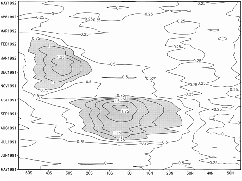
FIGURE 1.1 Zonally averaged difference between the optimum interpolation with and without satellite bias correction for 55 wee ks. The first week is April 28 to May 4, 1991; the last week is May 10 to May 16, 1992. The sign of the difference is “with-without” satellite correction. SOUR CE: Reynolds (1993).


