
2
The Value of Environmental Information
|
This chapter discusses:
|
Joint Publication 1-02 defines “battlespace” as the environment, factors, and conditions that must be understood to successfully apply combat power, protect the force, or complete the mission (Department of Defense, 1994). This includes the air, land, sea, space, enemy and friendly forces, facilities, weather, terrain, electromagnetic spectrum, and information environment within the operational areas and areas of interest. Since World War II, the operational area of U.S. Naval Forces has expanded globally to include all of the earth’s marine environments (with increasing emphasis on the littoral region (i.e., the zone from 200 nautical miles offshore to the amphibious objective area) and the atmosphere. A thorough understanding of all aspects of the environment is critical to the mission success of U.S. Naval Forces.
The Chief of Naval Operations has assigned responsibility for meeting environmental information requirements to the Office of the Oceanographer of the Navy (N096). Thus, the mission of the N096 organization is to provide global METOC information, Precise Time and Astrometry (PTA), and Global Geospatial Information and Services (GGI&S) critical to operations conducted by U.S Naval Forces and, as needed, any joint or coalition actions that may be involved in (see Box 2-1).
|
BOX 2-1 The METOC Operational Concept In May 2001 the Oceanographer of the Navy articulated a number of objectives that are the basis for the METOC Operational Concept:
|
Assumptions for the Operational Concept
SOURCE: Department of the Navy (2002). |
The diversity of naval warfare missions is illustrated by Table 2-1. Given the broad spectrum of modern naval operations, environmental information requirements to successfully conduct these missions are also remarkably diverse (see Table 2-2).
In meeting the demands of naval mission areas, the naval METOC community provides operational support resources to fleet commanders and their subordinate commands. The Oceanographer of the Navy is responsible for obtaining the resources needed to build and maintain the data, models, and other tools
TABLE 2-1 Naval Mission Areas Included in the General Requirements Relational Database
|
Mission Area |
Acronym |
|
Anti-Air Warfare |
AAW |
|
Amphibious Warfare |
AMW |
|
Anti-Surface Warfare/Over-the-Horizon Targeting |
ASW/OTHT |
|
Command/Control/Communications/Computers, Intelligence, Surveillance, and Reconnaissance |
C4ISR |
|
Logistics and Sealift/Joint Logistics Over the Shore |
LOG/JLOTS |
|
Mine Counter Measures/Mine Warfare |
MCM/MIW |
|
Operations Other Than War |
OOTW |
|
Naval Special Warfare |
NSW |
|
Strategic Deterrence and Weapons of Mass Destruction |
STRAT/WMD |
|
Strike Warfare |
STRIKE |
|
Undersea Warfare |
USW |
|
Wargames and Training Issues |
WGT |
|
SOURCE: Handfield and Clark (1999). |
|
necessary to monitor and predict environmental conditions of importance to each of the mission areas and those operations contained within the mission areas. The main engines for environmental information flow, modeling, and forecasting are two large computational centers ashore: the Naval Oceanographic Office (NAVOCEANO) and the Fleet Numerical Meteorology and Oceanography Center (FNMOC).
DATA COLLECTION
Traditionally METOC has not possessed a robust in-house observational network to rely on to meet its operations requirements, tending rather to rely on synoptic sensor data from a variety of external sources such as the World-Wide Weather Watch, the National Oceanic and Atmospheric Administration’s (NOAA) buoy data and ships of opportunity, NOAA and Department of Defense (DOD) satellite data, and historical archives maintained by NOAA’s Climate Center and NAVOCEANO archive data from TAGS ship collections. These synoptic data are assimilated at the two computational centers and used as input to large-scale numerical models, which are run on a routine daily schedule.
NAVOCEANO operates a fleet of oceanographic survey ships to collect information from the seafloor, ocean surface, and water column. The TAGS50 and TAGS60 class ships provide multipurpose oceanographic capabilities in coastal and deep-ocean areas, including physical, chemical, and biological oceanography; multidisciplinary environmental investigations; ocean engineering and
TABLE 2-2 Incidence of Environmental Parameters Within the 12 Naval Mission Areas (from Table 2-1 Above) as Reported in the General Requirements Database (GRDB)a
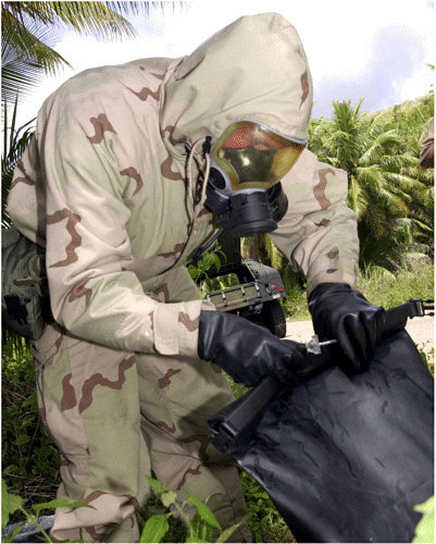
Naval personnel ensure that a chemical explosive device has been properly “decontaminated” during an exercise by checking for vapors. The exercise, Tri-Crab 2001, was a multinational, joint service, explosive ordnance disposal (EOD) training exercise involving teams from the U.S. Navy, U.S. Air Force, Royal Australian Navy, Royal Australian Air Force, and the Royal Singapore Navy (Photo courtesy of the U.S. Navy).
marine acoustics; marine geology and geophysics; and bathymetric, gravimetric, and magnetometric surveying.
In situ METOC measurements and observations are also a contributor to warfighting support products. These can be collected by either METOC personnel or, more commonly, the asset commander. For example, a deployed submarine may collect in situ information on the water column that can be used to improve a local model output if it were fed back to the METOC centers. The OA1 Division and the Mobile Environmental Teams are equipped to collect organic data. These METOC personnel collect local surface observations and upper-air soundings that can be transmitted back to FNMOC via the Automated Weather Network (AWN). In addition, the carriers have satellite full-resolution direct-readout capability, and the Mobile Environmental Teams have a reduced-resolution satellite readout capability. The OA officer afloat can also access environmental information from a wide variety of third-party providers such as foreign weather services, research and commercial satellite imagery, information from universities, and other research centers worldwide.
Remote Sensing
The U.S. Navy’s remote sensing program focuses on tactically significant information in the littoral regions. Environmental sensors on existing satellites are being exploited to the greatest extent possible, and new capabilities, such as those offered by WindSat and hyperspectral imagers, are under development. Remote sensors on airplanes, remotely piloted vehicles, surface ships, and undersea systems appear to be underutilized, as are environmental data that can be extracted from sensors deployed for other-than-environmental missions.
Modeling
Model output, in the form of gridded data fields, is the primary product from the two Navy computational centers. These fields are distributed by a variety of means, one of the most significant being the DOD’s AWN, operated by the U.S. Air Force. The gridded products are used by several DOD and civilian agencies, such as Defense Threat Reduction Agency for chemical dispersion modeling and NOAA as a backup hurricane forecast. Most importantly, they are used by the six METOC centers around the world to prepare ship routes and aviation forecasts.
Both the computational centers and the six regional centers can use the gridded output to run mesoscale models, such as the Coupled Ocean-Atmosphere Mesoscale Prediction System (COAMPS). COAMPS is a short-term (nowcast to 48-hour) mesoscale forecast tool for the littoral. A gridded mesocale model out
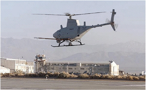
The U.S. Navy’s Fire Scout Vertical Takeoff and Landing Tactical Unmanned Aerial Vehicle (VTUAV) launches into its flight test program at the Naval Air Forces Western Test Range Complex in California. Fire Scout has been designed to provide situational awareness and precision targeting support for U.S. Naval Forces, as a fully autonomous UAV requiring limited human intervention. Future operations are planned for the UAV during the summer of 2003 (Photo courtesy of the U.S. Navy).
put can be forwarded to the OA division on aviation-capable ships, but typically regional center forecast products are delivered to customers as visual aids or text messages.
Forecasting
Direct forecasting support to staffs, ships, and units afloat and onshore is provided by officers and enlisted METOC personnel assigned to these activities. Permanently embarked METOC personnel and deployable assets (Mobile Environmental Teams) provide on-scene support for forces afloat and those in-theater onshore. The U.S. Navy’s permanently afloat METOC organic assets are its OA divisions, embarked onboard major aviation-capable combatants and command ships. The primary objectives are safety, optimum tactical support to warfare commanders, and tailored on-scene products and services.
Information flow for forecasting services is shown in Figure 2-1. The process begins with a standing order from the user community for a forecast. Data are assimilated, models initialized and run, and gridded outputs delivered to cus-
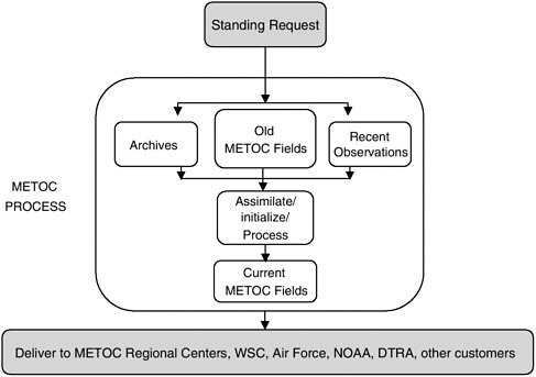
FIGURE 2-1 Diagram illustrating the typical one-way flow of synoptic and mesoscale gridded model output within the existing METOC system.
tomers. Typically, the forecasting process ends with METOC personnel providing a briefing or consultation with an asset commander. Forecasting services are essentially “stovepipe” services, meaning that the asset commander sees the output but has no intermediate data access or visibility into the process. The asset commander requests a product and receives it. Furthermore, there is presently no provision for customer interaction and feedback during the numerical process or to benchmark current performance of model output forecast products and tactical decision aids or other enhanced warfighting products.
Mission Objectives
The U.S. Navy METOC Strategic Plan implemented by N096 (The Department of the Navy, 1999) lists four mission objectives:
-
Optimized warfighting resources—Generate fiscal savings and increase military readiness through better forecasting of the global environment.
-
Advanced core competencies—Influence and exploit advances in science and technology to best characterize the natural environment.
-
Safe operating forces—Protect all assets.
-
Enhanced warfighting capabilities—Fully characterize the battlespace environment to the warfighter in terms that enable optimal employment of systems and platforms.
The first two mission objectives are internally focused, while the latter two have direct interface to operational commands and immediate impact on Navy warfighting missions (Table 2-1). As emphasized in the Statement of Task (see Chapter 1), this study’s focus is to examine the METOC community’s effectiveness in meeting the latter two externally focused missions in order to assist in optimizing strategies for meeting its internal mission objectives. Although the subject of much interest to individuals charged with monitoring fiscal resources, the objective to optimize warfighting resources differs so fundamentally from the other three objectives that tend to focus more closely on warfighter needs that the committee chose not to explore it in any detail.
Advanced Core Competencies
A primary focus of naval METOC functions is to provide timely environmental data and predictions to warfighters (Alberts et al., 1999). To achieve these objectives, the naval METOC system must be sufficiently robust and flexible to meet the information requirements of both day-to-day operations and specific demands of national security (driven by the specific objectives of a given operation) on a variety of spatial and temporal scales.
Research is conducted in four general areas: (1) physical understanding of environmental processes; (2) model development and prediction; (3) observations for prediction of parameters important to operational safety and military mission success, and (4) systems analysis, including the collection, fusion, and dissemination network. Crosscutting these areas are the three regions of the earth’s environment (atmosphere, land, and oceans), together with their coupling and interactions.
Research supported by the Navy intended to directly benefit “safe operating forces” traditionally focuses on improving the range and accuracy of synoptic and mesoscale forecasts. Research for “enhanced warfighting capabilities” is more diverse than for forecasting services and can include sensor array options, physical understanding of the environment, and distributed systems architectures, as well as model improvements.
Safe Operating Forces
Since the Navy typically operates in a peacetime environment, “safe operating forces” tends to capture the largest share of the community’s resources. The primary products meeting the safe operating forces mission objectives are derived from synoptic and mesoscale atmospheric and oceanographic model output.
Examples include Optimum Track Ship Routing (OTSR) and Optimum Aircraft Routing System (OPARS) forecasting services. However, as mentioned above, increases in efficiency due to improved observation, modeling, and forecasting are likely to result in only incremental improvements in efficiency in this area. Since naval capabilities in this area are sufficient and expected to remain so into the foreseeable future, increased investment in improved OTSR or OPARS is not recommended.
Enhanced Warfighting Capabilities
The product line for supporting the third N096 mission objective, enhanced warfighting capabilities, includes geospatial products, such as Special Tactical Oceanographic Information Charts (STOICS) and Special Annotated Imagery and model output from specialized tactical decision aids such as acoustic propagation prediction, ocean front and eddy thermal analysis of the ocean surface, or-
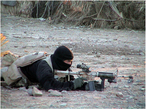
A U.S. Navy SEAL provides cover for his teammates while advancing on a suspected location of al Qaeda and Taliban forces. Supporting small, forward-deployed U.S. Navy special operations forces conducting missions in Afghanistan in support of Operation Enduring Freedom presented unique challenges to the U.S. Navy’s METOC community and Office of Naval Research (Photo courtesy of the U.S. Navy).
a nowcast of electromagnetic ducting conditions in the atmosphere’s boundary layer distortions). Products designed to enhance warfighting capabilities tend to be localized and focused on the littoral regions, with finer spatial resolution than the forecasting services described above for safe operating forces.
Environmental support for the warfighter is typically initiated at the Warfighting Support Center co-located with the NAVOCEANO computing center at Stennis Space Center, in Mississippi, or through one of the regional centers. Weapons systems performance can be affected by environmental conditions; thus, the Oceanographer of the Navy also has military and civilian staff assigned to each of the major systems commands—Naval Air Systems Command, Naval Sea Systems Command, and SPAWAR.
The information flow for preparing enhanced warfighting products is shown in Figure 2-2. As with the METOC synoptic and mesoscale forecasting products described earlier, warfighting support products are delivered through a traditional stovepipe process. The warfighter has no continuing input to, or information from, the process. Although some products, like STOICS, are offered via Web services as a smorgasbord of information downloadable by the warfighter, use of network technology for METOC for full customer interaction and product distribution is limited.
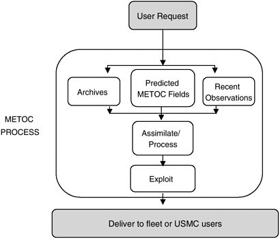
FIGURE 2-2 Diagram illustrating the typical one-way flow of information associated with Enhanced Warfighting Capability within the existing METOC system.
Furthermore, communications bandwidth is limited on most surface combatants other than carriers and is very small and often intermittent on submarines and in forward-deployed Marine units. There are no METOC personnel on submarines or small combatants; hence, the level of METOC training is different. Generally the flow is one way through the system from tasking to delivery. Opportunity for feedback is limited, and feedback mechanisms are not designed into the current system.
Warfare Areas
The principal naval warfare areas and the environmental parameters of importance to those warfare areas are tabulated in Table 2-3. Increasingly, there is a need for environmental information on finer spatial and temporal scales, including in some instances the requirement for near real-time environmental assessment in support of time-critical operations. However, as the spatial and temporal scales of environmental information are compressed, uncertainties regarding the accuracy, timeliness, coverage area, and assimilation of data expand. Further, many presently available METOC products (such as six-hour forecasts) are not sufficient for the information needs of rapidly changing battlespace conditions. Thus, uncertainty regarding the state of the environment remains a critical limitation to enhanced warfighting capabilities. There is an important and growing need in the METOC community to develop meaningful assessment and evaluation metrics to characterize uncertainty in environmental information and to determine the impact of that uncertainty on naval operations. At present, the general requirements for environmental information are developed through a complex and often cumbersome process. The role of warfighters and users in developing quantitative estimates for some critical thresholds, or other numerical expression of platform or personnel sensitivity, is limited. This is somewhat understandable, as much information gained through such exchange is allegorical in nature and difficult to quantify. However, as more robust methods for capturing warfighter experience are developed and as weapons systems with specific and clearly expressed environmental tolerances become more widespread, quantifying the needed accuracy of environmental information will become easier. At the same time, there will be a greater need to provide indoctrination and training of METOC personnel in the characterization and understanding of uncertainty such that corresponding analyses of risks associated with those uncertainties can be conveyed to warfighters and asset commanders.
STRATEGIES FOR TARGETING INVESTMENT IN RESEARCH AND DEVELOPMENT
The gauge of success in business is straightforward—creation of profits through the sale of popular products or services. Success is a bottomline figure—
TABLE 2-3 Relevance of Environmental Parameters to Naval Warfare Areasa
|
Environmental Parameter |
AMW/ NSW |
ASW/ USW |
MIW/ MCM |
STRAT/ WMD |
STRIKE |
MULTI |
|
Aerosols, haze, smoke |
X |
X |
X |
X |
X |
X |
|
Air turbulence |
X |
X |
X |
X |
X |
X |
|
Anchorages |
X |
X |
X |
X |
|
X |
|
Astronomical time |
X |
X |
X |
X |
|
X |
|
Barometric pressure |
X |
|
|
X |
X |
X |
|
Beach slope |
X |
X |
X |
X |
|
X |
|
Beach trafficability |
X |
X |
X |
X |
|
X |
|
Bioluminescence |
X |
X |
X |
X |
|
X |
|
Blowing sand |
X |
X |
X |
X |
X |
X |
|
Bottom gradient |
X |
X |
X |
X |
|
X |
|
Bottom loss |
X |
X |
X |
X |
|
X |
|
Bottom roughness |
X |
X |
X |
X |
|
X |
|
Breaker direction |
X |
X |
X |
X |
|
X |
|
Breaker height |
X |
X |
X |
X |
|
X |
|
Breaker interval |
X |
X |
X |
X |
|
X |
|
Breaker type |
X |
X |
X |
X |
|
X |
|
Ceiling layers |
X |
X |
X |
X |
X |
X |
|
Cloud cover, type, etc. |
X |
X |
X |
X |
X |
X |
|
Clutter density |
X |
X |
X |
X |
|
X |
|
Convergence zone |
X |
X |
X |
X |
|
X |
|
Currents (bottom) |
X |
X |
X |
X |
|
X |
|
Currents (surface) |
X |
X |
X |
X |
|
X |
|
Currents (water column) |
X |
X |
X |
X |
|
X |
|
Dew point |
X |
X |
X |
X |
X |
X |
|
Ducting |
X |
X |
X |
X |
X |
X |
|
Fog |
X |
X |
X |
X |
X |
X |
|
Frequency stability |
X |
X |
X |
X |
|
X |
|
Humidity |
X |
X |
X |
X |
X |
X |
|
Ice edge |
X |
X |
X |
X |
|
X |
|
Icebergs |
|
X |
X |
|
|
X |
|
Icing (aircraft) |
X |
X |
X |
X |
X |
X |
|
Icing (sea surface) |
X |
|
|
|
|
X |
|
Inversion rate |
X |
|
|
X |
X |
X |
|
Ionospheric scintillation |
X |
|
|
|
X |
X |
|
Lightning |
X |
X |
X |
X |
X |
X |
|
Magnetic anomalies |
X |
X |
X |
|
|
X |
|
Marine mammals |
X |
X |
X |
X |
|
X |
|
Moisture profile |
X |
X |
X |
X |
X |
X |
|
Moon angle |
X |
X |
X |
X |
|
X |
|
Moon illumination |
X |
X |
X |
X |
|
X |
|
Moon phase |
X |
X |
X |
X |
|
X |
|
Moon rise/set |
X |
|
|
|
X |
X |
|
Noise (biological) |
X |
X |
X |
X |
|
X |
|
Noise (precipitation) |
X |
X |
X |
X |
|
X |
|
Noise (sea ice) |
X |
X |
X |
X |
|
X |
the net profit from operations. Thus, inherent in business is an objective value system that forms a clear basis for planning.
While most businesses invest in Research and Development, no major business would proceed with such an investment without a full business plan. Such a plan consists of three components. The first is a financial model for payback on investments through later profits. It represents the best guess of planners on the response of the future market to the developed products. The second, and equally important, aspect of planning is an analysis of risk. It is recognized that the payback model contains many assumptions whose failure could have serious consequences. Probabilities must be estimated and the financial impact of various scenarios computed. Finally, the risk posture of the company must be assessed and an acceptable level determined. The final investment strategy, then, is that which provides the optimum payback within the level of risk that is acceptable to the business.2
Application of Business Principles to Naval METOC Operations
Development of an objective basis for investment in METOC by the Department of the Navy requires application of the same business principles and logic (e.g., cost-benefit or risk posture analysis) to the METOC problem.3 This, in turn, requires development of an appropriate value system for naval activities and the impact of METOC on those activities. It also requires a risk analysis to quantify the potential impact of chance on operations. Finally, an assessment must be made of the risk level that is acceptable in expected operations. With these elements quantified, objective decisions can be made.4
In considering the value of METOC, it could be concluded that improvements in METOC capability have value in two ways. A direct but small value comes from efficiency gains such as Optimum Track Ship Routing (OTSR), resulting from improved knowledge of the environment. This might yield significant savings each year. The second value comes from risk reduction. Even if only a very small fraction of operations were impacted through improved risk management, this value would dwarf that from optimized resource applications such as OTSR. The costs of lost aircraft or ships, of lost lives, or of failed missions with possible hostage consequences are enormous. Thus, the following
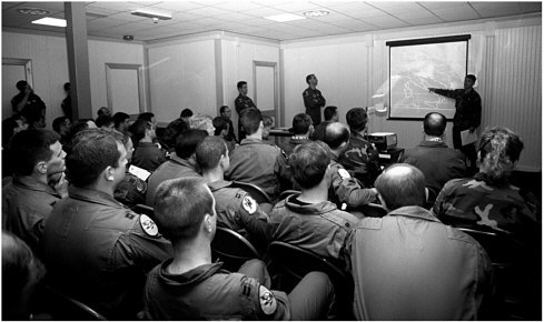
METOC briefings are a regular component of the premission preparation for U.S. Navy and Marine pilots. The intimacy and regularity of these briefings represent a unique interaction between information provider and warfighter. In most other naval mission areas, environmental information is provided periodically and by electronic means. In such situations, greater effort must be made to capture feedback from the warfighter on the timeliness and value of the information received (Photo courtesy of the U.S. Navy).
discussion focuses on the role of METOC in naval risk management, leaving resource maximization efforts as secondary and already well handled.
The application of business principles to military operations is not straightforward. How should a value be placed on freedom, peace, or open commerce? How well can risk from environmental factors be quantified in military operations? How much risk from environmental factors should operational commanders be willing to accept? Assessment of these matters can be very difficult. However, by attempting to bound the problem, a number of useful points arise.
Risk Within the Military
While risk is inherent in all military operations, there is a clear and, in recent years, high value placed on risk reduction in military operations. Mission failure not only results in the nonaccomplishment of an important task but also draws the attention of a public and press that are overly accustomed to winning. The loss of combatants and even the presence of collateral civilian casualties can have a compromising effect on the very foreign policy that military action is intended to help implement. Perhaps even worse is the situation of military or civilian hostages. The acceptable cost of hostage rescue is huge, as can be the acceptable
compromise of policy for hostage rescue purposes. Even acknowledgment of environmental uncertainty in planning brings associated costs in the form of costly contingency plans or low-risk suboptimal mission plans.
Risk in military operations comes from two primary sources. The first is the unpredicted activities of the enemy (e.g., change in location, mounting a defense, counterattack). This is mitigated, usually successfully, through reconnaissance gathering. The second source comes from the unpredictability of the environment. It is this source of uncertainty that is addressed by the METOC enterprise and will also be the focus of the remaining discussion.
In a business model, risk assessment requires quantification of the probabilities of certain risks and their associated financial impacts. From the cumulative knowledge of these quantities over all possible risk mechanisms, an assessment can be made of the likelihood of various outcomes. These can be compared to a business’s risk posture to determine if the plan is good or if alternates should be sought.
A risk analysis for METOC would similarly require an assessment of the probability of unpredicted harmful conditions weighted by an assessment of the impact of those conditions on the goal (e.g., determination of the impact of mission failure and/or loss of life). Together, these can be defined as the cost of uncertainty.
The Idea of a Cost of Uncertainty
The environment affects all military operations, sometimes simply by introducing inconvenience but other times in a show-stopping role that can change history. Thus, it is no surprise that the environment has played an important role in military conflicts throughout the ages. For example, the harsh Russian winters repeatedly doomed invading armies. At sea, entire fleets have been lost due to foul weather. More recently, the failure of the rescue mission of the hostages in Iran had enormous costs, holding captive U.S. foreign policy for a year and contributing to the demise of the Carter presidency. The successful effort to rescue U.S. citizens on the island of Grenada in 1983 was marred by the loss of four Navy SEAL team members involved in a night jump into coastal waters during marginal weather conditions. It has been estimated that 75 percent of naval special warfare missions are severely degraded due to METOC problems (LCDR Bruce Morris, personal communication).
The Goal of the METOC Enterprise
It is unlikely that we will be able to control the weather in the foreseeable future; thus, our goal is instead to know the current state of the environment and make useful predictions of its future state. The environment affects both sides of a conflict. Difficult conditions can be an impediment or at times an advantage.
The tactical goal is to minimize risk while maximizing the possible advantage of the environment. The METOC goal is to facilitate that objective through perfect knowledge of the environment.
In a world of perfect environmental knowledge, decisions made by leaders in mission planning could be perfect.5 However, constraints of both a physical nature and a fiscal nature will always limit our ability to know and predict natural systems. It is the introduction of uncertainty due to environmental unknowns that has risk and introduces cost. Thus, reduction of this uncertainty is the goal of the naval METOC enterprise, and it is the cost of the uncertainty that provides a gauge for the value of METOC knowledge.
It is a central hypothesis of this study that the goal of the naval METOC enterprise is the reduction of uncertainty due to environmental factors in mission planning and operations. Thus, the optimum investment strategy is that which provides the largest reduction in the cost of uncertainty for the smallest investment cost. An important consequence of this hypothesis is the need for the naval METOC community to embrace the concept of uncertainty and uncertainty reduction as fundamental to METOC products.
SUMMARY
The naval METOC enterprise is a complex system of platforms, personnel, and computer systems designed to support operations carried out by the U.S. Navy and Marine Corps by producing high-quality tailored environmental information products. The intended consumers of this information include decisionmakers facing a variety of complex choices, some of which may be significantly affected by environmental processes operating at a variety of temporal and spatial scales. There is an apparent lack of a clear performance metric, including a robust understanding of how platforms and personnel are affected by environmental processes. Valid and quantifiable feedback from warfighters and other operators, while difficult to obtain, is needed if objective criteria for data acquisition are to be established. Limited funding, limited time, and the rapidly evolving nature of naval and expeditionary warfare make sound decisions regarding data acquisition and dissemination a high priority in the naval METOC community. Establishing the value (dollar amount) of environmental information for military decisionmaking may seem an impossible task given the complexities of military operations and the uncertainties of enemy intent. The value of such an exercise would be substantial, just as understanding the economic costs of natural disasters helps define debates over budget priorities for emergency services. The first step in understanding the value of environmental information lies in understanding its present use in various naval operations.


