
2
U.S. Strategic Interests and Missions in the Polar Regions
Scientific exploration of Antarctica began in earnest in the early 1950s when the 67 member nations of the International Council of Scientific Unions (ICSU) endorsed a proposal to conduct an International Geophysical Year (IGY) in 1957-1958 and intensive, scientific exploration of Antarctica began on an international level.1 The ICSU nations agreed that the IGY would focus especially on research in Antarctica and outer space. Twelve of the ICSU member countries (Argentina, Australia, Belgium, Chile, France, Japan, New Zealand, Norway, South Africa, the United Kingdom, the United States, and the Soviet Union) met in July 1955 to commence planning the Antarctic science program. Up to this point, only a few permanent stations had been established in Antarctica. The first recorded ongoing settlement dates back to 1903 when the Scottish National expedition established a building on Laurie Island. The station was handed over to Argentina the following year and was later named Orcadas. It is the longest continuously operating station in Antarctica. During International Geophysical Year activities in 1957, more than 40 stations were established in Antarctica for the IGY at many points around the continent, including two on the Antarctic plateau: one at the South Pole by the United States and the other at the Pole of Inaccessibility (farthest points from the coasts) by the Soviet Union.
During the International Geophysical Year 1957-1958, the United States committed to a significant program of exploration and study of the Antarctic and has maintained an active presence in Antarctica ever since. The United States was instrumental in the development of the Antarctic Treaty of 1959, which was signed in Washington, D.C., on December 1, 1959, and entered into force on June 23, 1961. The Antarctic Treaty System includes a series of agreements that regulate relations among states in Antarctica. The original 12 signatories consisted of the seven countries with claims over parts of Antarctica—Argentina, Australia, Chile, France, New Zealand, Norway, and the United Kingdom— and five other countries with Antarctic activities, namely Belgium, Japan, South Africa, the Soviet Union, and the United States.
Today the Antarctic Treaty System2 is embedded in a system of conventions, measures, and annexes that reflect changes in the world over nearly the last five decades. Evolution of the geopolitical framework that brought the original 12 founding nations together has resulted in correlative changes in U.S. influence and interests in Antarctica. The original 12 member nations have now grown to 45 countries that accede to the Antarctic Treaty (Table 2.1). These 45 countries represent two-thirds of the world’s population.
The Antarctic Treaty requires that governing countries
TABLE 2.1 List of Signatories to the Antarctic Treaty
|
No. |
State |
Date |
Status |
Date Acceding State Became Consultative Party |
|
1 |
United Kingdom |
May 31, 1960 |
OS/CP |
|
|
2 |
South Africa |
June 21, 1960 |
OS/CP |
|
|
3 |
Belgium |
July 26, 1960 |
OS/CP |
|
|
4 |
Japan |
August 4, 1960 |
OS/CP |
|
|
5 |
United States of America |
August 18, 1960 |
OS/CP |
|
|
6 |
Norway |
August 24, 1960 |
OS/CP |
|
|
7 |
France |
September 16, 1960 |
OS/CP |
|
|
8 |
New Zealand |
November 1, 1960 |
OS/CP |
|
|
9 |
Russiaa |
November 2, 1960 |
OS/CP |
|
|
10 |
Poland |
June 8, 1961 |
AS/CP |
July 29, 1977 |
|
11 |
Argentina |
June 23, 1961 |
OS/CP |
|
|
12 |
Australia |
June 23, 1961 |
OS/CP |
|
|
13 |
Chile |
June 23, 1961 |
OS/CP |
|
|
14 |
Czech Republicb |
June 14, 1962 |
AS |
|
|
15 |
Slovak Republicb |
June 14, 1962 |
AS |
|
|
16 |
Denmark |
May 20, 1965 |
AS |
|
|
17 |
Netherlands |
March 30, 1967 |
AS/CP |
November 19, 1990 |
|
18 |
Romania |
September 15, 1971 |
AS |
|
|
19 |
German Democratic Republicc |
November 19, 1974 |
AS/CP |
October 5, 1987 |
|
20 |
Brazil |
May 16, 1975 |
AS/CP |
September 12, 1983 |
|
21 |
Bulgaria |
September 11, 1978 |
AS/CP |
May 25, 1998 |
|
|
Germany, Federal Republic of |
February 5, 1979 |
AS/CP |
March 3, 1981 |
|
22 |
Uruguay |
January 11, 1980 |
AS/CP |
October 7, 1985 |
|
23 |
Papua New Guinead |
March 16, 1981 |
AS |
|
|
24 |
Italy |
March 18, 1981 |
AS/CP |
October 5, 1987 |
|
25 |
Peru |
April 10, 1981 |
AS/CP |
October 9, 1989 |
|
26 |
Spain |
March 31, 1982 |
AS/CP |
September 21, 1988 |
|
27 |
China, People’s Republic of |
June 8, 1983 |
AS/CP |
October 7, 1985 |
|
28 |
India |
August 19, 1983 |
AS/CP |
September 12, 1983 |
|
29 |
Hungary |
January 27, 1984 |
AS |
|
|
30 |
Sweden |
April 24, 1984 |
AS/CP |
September 21, 1988 |
|
31 |
Finland |
May 15, 1984 |
AS/CP |
October 9, 1989 |
|
32 |
Cuba |
August 16, 1984 |
AS |
|
|
33 |
Korea, Republic of |
November 28, 1986 |
AS/CP |
October 9, 1989 |
|
34 |
Greece |
January 8, 1987 |
AS |
|
|
35 |
Korea, Democratic People’s Republic of |
January 21, 1987 |
AS |
|
|
36 |
Austria |
August 25, 1987 |
AS |
|
|
37 |
Ecuador |
September 15, 1987 |
AS/CP |
November 19, 1990 |
|
38 |
Canada |
May 4, 1988 |
AS |
|
|
39 |
Colombia |
January 31, 1989 |
AS |
|
|
40 |
Switzerland |
November 15, 1990 |
AS |
|
|
41 |
Guatemala |
July 31, 1991 |
AS |
|
|
42 |
Ukraine |
October 28, 1992 |
AS/CP |
May 27, 2004 |
|
43 |
Turkey |
January 25, 1996 |
AS |
|
|
44 |
Venezuela |
May 24, 1999 |
AS |
|
|
45 |
Estonia |
May 17, 2001 |
AS |
|
|
NOTE: OS = original signatory; CP = consultative party; AS = acceding state; dates represent the dates of ratification of the treaty by the original signatories or the dates of accession or succession by other states. aKnown as the Soviet Union until December 1990. bSucceeded to the Treaty as part of Czechoslovakia which separated into two republics on January 1, 1993. cBecame united with Federal Republic of Germany on October 3, 1990 (now known as Germany). dAcceded to the Treaty after independence from Australia. SOURCE: Antarctic Treaty Secretariat web site (http://www.ats.aq) |
||||
conduct an active scientific program in the region. In the United States, the State Department is the U.S. representative in the Antarctic Treaty process, and management of the United States Antarctic Program (USAP) was assigned to the National Science Foundation by Presidential Memorandum 6646 (1982). National policy directives have consistently reiterated the national importance of maintaining a visible presence and an active U.S. Antarctic Program in the region. U.S. interests were most recently articulated in a Presidential Decision Directive (NSC, 1994), which states four U.S. interests in Antarctica:
-
Protecting the relatively unspoiled environment of Antarctica and its associated ecosystems;
-
Preserving and pursuing unique opportunities for scientific research to understand Antarctica and global physical and environmental systems;
-
Maintaining Antarctica as an area of international cooperation reserved exclusively for peaceful purposes; and
-
Ensuring the conservation and sustainable management of the living resources in the oceans surrounding Antarctica.
In 1996, the Committee on Fundamental Science of the President’s National Science and Technology Council (NSTC) reviewed U.S. activities in the polar regions. That committee confirmed that “the National Science Foundation has implemented U.S. Policy in an effective manner” and that “the USAP research program is of very high quality” (NSTC, 1996). In 1997, an in-depth review of the U.S. Antarctic Program again confirmed the importance of a continued strong science program in the Antarctic and made recommendations for improvement (NSF, 1997). In a recent briefing to this Committee, the Department of State once again stated that it is essential for the United States to maintain an active and influential presence in Antarctica, including but not limited to year-round operation of the South Pole Station and other permanent stations. The long-term cooperative management of Antarctica achieved under the Antarctic Treaty is a significant accomplishment and the central role of science cannot be overstated.
Under the treaty, the United States and other signatories are guaranteed freedom of scientific research and provided inspection rights to ensure compliance. Specifically, the Antarctic Treaty ensures “in the interests of all mankind that Antarctica shall continue forever to be used exclusively for peaceful purposes and shall not become the scene or object of international discord.” To this end it prohibits military activity, except in support of science; prohibits nuclear explosions and the disposal of nuclear waste; promotes scientific research and the exchange of data; and holds all territorial claims in abeyance for 50 years. The treaty applies to the area south of 60 degrees South Latitude, including all ice shelves and islands. As for the sovereignty issue, the status quo of 1959 with regard to claims or their recognition is maintained, although the claims of many nations remain unresolved and overlapping (Figure 2.1). “No acts or activities taking place while the present Treaty is in force shall constitute a basis for assenting, supporting or denying a claim to territorial sovereignty in Antarctica or create any rights of sovereignty in Antarctica” (Antarctic Treaty, 1959).
With the increased interest in Antarctica, human presence has increased over the years as more nations have joined the Antarctic Treaty system, and many more scientific stations have been established. It is important to note, however, that the maximum number of U.S. personnel present in Antarctica actually peaked during Operation Deep Freeze at the height of the Cold War. Since that time, the increased level and complexity of human activities in Antarctica have been due to the ever-increasing presence of other nations’ personnel and the establishment of additional scientific bases in Antarctica. In addition, as technology and scientific advances shrink the globe, interest in the natural resources of Antarctica has increased. Although no mineral or resource exploitation (other than fisheries and tourism) has taken place in Antarctica, as perceived distances to market decrease and commodity prices increase, the pressure to exploit this once-remote continent are expected to increase.
The United States has strong interest in preserving and protecting one of the most pristine environments on the globe, ensuring that the Antarctic continent is reserved exclusively for peaceful purposes, and pursuing unique opportunities to gain new scientific knowledge. In support of these interests, the United States does not claim territory in Antarctica (although it does maintain the basis for a claim) and it does not recognize the (overlapping) territorial claims made by seven other countries (Figure 2.1). Although, the U.S. Antarctic Program remains by far the largest in the world,3 the operation of the treaty by unanimous consent and the one country-one vote approach has meant in recent years that U.S. influence has diminished and its leadership is challenged on a regular basis. However, as the lead proponent of the original treaty, the United States has established an influential presence in Antarctica and as such has served a critical role in maintaining the integrity of the Antarctic Treaty and fostering an atmosphere of cooperation and partnership.
The influential U.S. presence in Antarctica is principally a result of the operations of the U.S. Antarctic Program and its three year-round research stations: McMurdo Station, Palmer Station, and South Pole Station. This presence protects the U.S. stance on Antarctic sovereignty, secures the United States an influential role in the treaty’s decision-making system, and helps maintain the political and legal balance necessary for success of the treaty. Many view the permanent year-round presence of the United States as a major
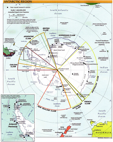
FIGURE 2.1 Antarctic territorial claims.
deterrent to those countries that might otherwise wish to exercise their territorial claims. The South Pole Station is of particular importance to sovereignty issues because the South Pole is at the apex of the areas claimed by the seven countries that assert territorial claims. The year-round presence of U.S. scientists at South Pole Station preserves U.S. interests and influence.
The U.S. national presence in the Antarctic is possible at present because of the logistical support of U.S. military forces that are charged to resupply the permanent science stations. Both Navy and U.S. Coast Guard icebreakers supported Antarctic operations until the U.S. Coast Guard assumed all polar icebreaker responsibilities in 1965. The U.S. Navy continued to provide airlift support to Operation Deep
Freeze (the long-lived science mission) until the mid-1990s, when this task was transferred to the Air National Guard. The principal role of the U.S. Coast Guard has been to provide logistics support to the U.S. Antarctic Program by breaking a channel into McMurdo Sound to allow resupply of McMurdo Station by tanker and cargo ships. Supplies from McMurdo are transferred to the South Pole Station by air, recently supplemented on a developmental basis by ground traverse. Icebreakers are a lifeline to and critical for the maintenance of USAP operations at the shore of McMurdo Sound and at the South Pole.
Until recently, the two Polar class icebreakers (sometimes together and sometimes separately depending on ice conditions) were used to break open a channel for resupply.4 However, more challenging ice conditions and the deteriorating status of the Polar class ships now adds uncertainty and risk of failure to the operation. The National Science Foundation (NSF) is concerned that the lack of reliable icebreaking support may make it increasingly difficult to maintain the permanent stations and associated science programs. Investigations of alternate logistics plans by NSF (discussed in Chapter 8) have reaffirmed that icebreaker support is necessary to the Antarctic resupply chain for now and in the foreseeable future. According to a representative of the Department of State assigned to Antarctic issues, if resupply of South Pole Station is not successful and the station were abandoned, this would jeopardize, and probably reduce, the influence of the United States in Antarctic governance. There would be significant consequences because abandonment of that key site would create a vacuum in leadership and likely result in a scramble for control. Abandoning it would be detrimental to the U.S. position as well as to the stability of the treaty system. To preserve the U.S. presence in Antarctica and hence its influential role in the Antarctic Treaty, it is paramount to maintain the three permanent research stations and their associated active research programs throughout the Antarctic continent. Icebreaker operations are critical to the continued existence of these stations and their associated outlying field sites.
THE U.S. ARCTIC PRESENCE
The United States is one of eight nations that have territory and citizens in the Arctic. Thus, the nation has obligations to the population of Alaska as well as a range of international responsibilities, treaty obligations, and policy interests in the region. New opportunities for Arctic cooperation arose in the late 1980s (shortly before the dissolution of the former Soviet Union) and “environmental cooperation was identified as a first step in promoting comprehensive security in the region” (www.arctic-council.org). The eight Arctic nations (Canada, Denmark [including Greenland and the Faeroe Islands], Finland, Iceland, Norway, the Russian Federation, Sweden, and the United States) adopted an Arctic Environmental Protection Strategy in 1991, and in 1996 the Arctic Council was formed. The United States is a founding signatory and member state of the Arctic Council, a regional intergovernmental forum whose purpose is to address all aspects of sustainable development—environmental, social, and economic—addressing issues and challenges shared by the Arctic nations.
The most recent National Security Council policy review of U.S. Arctic policy, undertaken in 1994, lists “national security and defense” as among the key principal interests in the Arctic. Typically, U.S. national security and foreign policy concerns in the Arctic involve sovereignty and jurisdictional issues within the Arctic Ocean. Since the Arctic Ocean is treated like other oceans for purposes of sovereignty and jurisdictional claims, issues typically focus on freedom of access to ice-covered boundary areas as well as international straits and waterways in the Arctic, such as the Bering Strait and the Northwest Passage.
In addition, obligations under international agreements, such as the United States-Denmark bilateral agreement regarding airbases in Greenland and the multilateral agreement concerning the North Atlantic Ice Patrol, must be fulfilled. At present, resupply of the U.S. Thule Air Force Base in Greenland is achieved through an agreement between the Canadian and U.S. Coast Guards. The Canadian Coast Guard is responsible for resupplying the base in exchange for icebreaking services provided by the U.S. Coast Guard in the western Arctic. Reciprocal support for Canadian icebreaking requirements is routinely offered. In practice, this has consisted mostly of joint science program support, and operational support, such as resupply of the Surface Heat Budget of the Arctic Ocean (SHEBA) project in 1998.
Of special importance in the near term is the approaching enforcement of the 1982 U.N. Convention on the Law of the Sea. Since the seventeenth century, the oceans have been subject to a “freedom of the seas” doctrine, a principle limiting national rights and jurisdiction over the oceans to a narrow belt of sea surrounding a nation’s coastline. The remainder of the seas was proclaimed free to all and belonging to none, but by the mid-twentieth century there was growing concern over the toll on coastal fish stock caused by long-distance fishing fleets, pollution from transport ships, and other demands. In 1945 the United States extended its jurisdiction to include all natural resources on the continental shelf; other nations soon followed suit. As pressure on ocean resources increased, amplified by advances in technology, discussions began in 1973 that culminated in the 1982 adop-
|
BOX 2.1 United Nations Convention on the Law of the Sea Article 76 of UNCLOS outlines the specific geologic and morphological criteria to be followed in delimiting the continental shelf. It is based largely on either of two formulas (Mayer, 2003; Gardner et al., 2006): a distance formula that allows an extension of the shelf to 60 nmi beyond the foot of the continental slope (defined as the point of maximum change in gradient at its base) (Figure 2.2), or a sedimentary rock thickness formula that allows extension of the shelf to where the thickness of sediments (or sedimentary rock) is 1 percent of the distance back to the foot of the slope (Figure 2.2). Following either of these criteria, the outer limit (cutoff lines) of the continental shelf cannot extend more than 350 nmi from the coast, or cannot exceed 100 nmi from the 2,500-meter isobath, whichever is more beneficial for the coastal state. In the U.S. Arctic, the continental shelf may extend as far as 600 nmi from the baseline. Key to implementing any of these criteria are a clear bathymetric delineation of the 2500-meter isobath and the foot of the continental slope and accurate geophysical data to determine seabed sediment thicknesses. Submission by any country of its continental shelf limits will be based on a combination of high-resolution, state-of-the-art bathymetric and geophysical data. However, scientific knowledge of seafloor geology involves more than just bathymetry and sediment thickness. Article 76, paragraphs 3 and 6, makes a distinction between oceanic ridges, submarine ridges, and submarine elevations that are natural components of the continental margin, such as plateaus, rises, caps, banks, and spurs. The interpretation of these definitions impacts how one defines shelf delimitation. The treaty states that the continental margin consists of the submerged prolongation of the landmass of the coastal state. Yet, the distinction between those parts of the ocean that are a natural prolongation of the landmass and those that are part of the deep ocean floor lies in the geologic and tectonic context of the rocks. The wording implies that the continental shelf may extend to 200 nmi on oceanic ridges, to 350 nmi on submarine ridges, and to either 350 nmi or 100 nmi beyond the 2,500-meter isobath on submarine elevations. According to one interpretation (http://www.unclosnz.org.nz/ridges.html), if the feature is morphologically continuous with the continental margin regardless of its origin, and is not an oceanic ridge, then it is either a submarine ridge or a submarine elevation that is a natural component of the margin, depending on the degree of geological and tectonic continuity between the landmass and the ridge. What is important to grasp is that seabed claims require sound geological data. Any submission for an extended continental shelf by the United States in the Arctic would likely be based on the sediment thickness formula. This requires precise data on the location of the foot of the continental slope (based on bathymetry) and would be limited by the position of the 2,500-meter isobath plus 100 nmi. The U.S. claim will require both accurate bathymetry and accurate sediment thickness data. |
tion by the United Nations of a constitution for the seas, the U.N. Convention on the Law of the Sea (UNCLOS).
UNCLOS was crafted to manage and protect the natural resources of the world’s oceans and outline unifying provisions concerning rights of maritime navigation, transit regimes, continental shelf jurisdiction, exclusive economic zones (EEZs), and seabed mining. Exactly 149 countries have ratified the convention, including almost every industrialized nation except the United States.5 When first proposed in 1982, President Ronald Reagan had objections to the convention’s provisions on seabed mining. This part of the convention was rectified in the 1994 Agreement on Part XI. President Clinton signed the treaty and sent it to Congress where it still awaits accession. It is clear that accession to the treaty by Congress has been supported by more than one administration with the concurrence of the Senate Foreign Relations Committee, the U.S. Commission on Ocean Policy, the Pew Commission, the U.S. Navy, and others. Because the United States is the world’s largest maritime power with the longest coastline and largest continental shelves in the world, the country is poised to benefit the most from ratification. This far-reaching framework is consistent with our national security, economic, and environmental interests in the oceans while promoting international approaches to dispute settlements and means of managing open sea resources.
UNCLOS allows a territorial sea for all coastal nations extending 12 nautical miles (nmi) from the shore (baseline),
|
5 |
A list of all countries that have ratified UNCLOS, dates of ratification, and so forth is available on the Web at http://www.un.org/depts/los/reference_files/chronological_lists_of_ratifications.htm#Agreement%20relating%20to%20the%20implementation%20of%20Part%20XI%20of%20the%20Convention. |
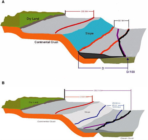
FIGURE 2.2 Specific geologic and morphological criteria to be followed in delimiting the continental shelf for UNCLOS claims. SOURCE: L. Mayer, University of New Hampshire.
within which countries can exercise their sovereignty (1 nautical mile = 1.852 km, or 1.150779 statute mile) (Figure 2.1). Beyond this limit, the convention recognizes a contiguous zone to a distance of 24 nmi, in which a country can exert limited controls necessary to prevent and punish infringements of immigration, customs, fiscal, and sanitary laws that occur in its territory or its territorial sea. The treaty also provides coastal countries with the sovereign right to explore and exploit resources (e.g., fisheries, oil, gas, gas hydrates) from their EEZ to a distance of 200 nmi from the coast. Moreover, it allows coastal states the sovereign right to explore and exploit the natural resources of the continental shelf both within and beyond 200 nmi based on a fixed set of geologic criteria (see Box 2.1 and Figure 2.2).
U.S. accession to UNCLOS will set in motion a 10-year deadline for the United States to make a submission on the limits of its continental shelf beyond 200 nmi to the Commission on the Limits of the Continental Shelf (CLCS). Article 76 of UNCLOS outlines the specific geologic and morphological criteria to be followed in delimiting the continental shelf. To do this, or even to substantiate a claim independent of the UNCLOS process, the United States must conduct extensive bathymetric and geologic studies.
The submission of claims to the CLCS was expected to take place within 10 years of any nation acceding to the treaty (under Article 4 of annex II to the Convention). Among the Arctic nations, Finland signed on in June 1996; Norway and Sweden in November 1996; Iceland in February 1997; Russia in March 1997; Canada in March 2003; and Denmark in November 2004. The United States is the last Arctic nation still to sign the UNCLOS treaty. Because of the complexity and technical challenges faced by some developing nations and island states seeking shelf extensions and, significantly, because the Science and Technological Guidelines for delimiting shelf extensions were not adopted until May 1999, it was agreed by parties to the convention in June 2001 that all countries ratifying UNCLOS before 1999 have until May 2009 to submit their claims (SPLOS/73, 2001). Russia made its initial submission on December 20, 2001, but was told to resubmit with additional geologic evidence. All other Arctic countries have active science programs involving icebreaker support in data gathering across their respective Arctic shelf borderlands.
Some countries that have made submissions spent more than 10 years collecting and analyzing the required data, which suggests that the United States should begin as quickly as possible to move forward with a coordinated research plan for continental shelf delimitation. In the Arctic, this will require icebreaker support.
U.S. scientists have already begun the task of gathering the bathymetric data needed for submitting our claim to the continental shelf beyond 200 nmi. Since 2002, the University of New Hampshire’s Center for Coastal and Ocean Mapping-Joint Hydrographic Center has been tasked by Congress, through a grant from the National Oceanic and Atmospheric Administration, to conduct seafloor bathymetric mapping using high-resolution multibeam echo sounding technology. Selected portions of the continental shelf have already been mapped, including parts of the Arctic margin off northern Alaska and the Bering Sea (Gardner et al., 2006). However, a great deal of the Arctic Basin adjacent to the Alaskan Chukchi and Beaufort shelves remains to be explored, especially addressing the question of sediment or sedimentary rock thicknesses and tectonic relationships to the adjacent shelf. The U.S. claim will require both accurate bathymetry and sediment thickness data (L. Mayer, personal communication, 2006). Although some seismic surveys conducted by U.S. scientists in 2005 and 2006 on the HEALY6 could eventually contribute to the database for future U.S. claims, the United States, as present, does not have an immediate research strategy or focused proposal competition for determining sediment thickness or for the geologic and tectonic continuity of submerged portions of the continental shelf (i.e., the Chukchi Cap). What will be needed are high-density surveys of multichannel seismic data, gravity data, and sonobuoy velocity calibrations executed in a fashion adapted to Arctic conditions. The collection of these data will, by necessity, require the support of the U.S. polar icebreakers to ensure that data of sufficient quality and quantity are collected to make a legitimate claim of sovereign rights over a larger part of the Arctic Basin beyond the present 200 nmi EEZ limit.7
Asserting a national presence in the Arctic requires access to the region, and icebreaker support is the preferred way of ingress into ice-covered boundary areas. Although U.S. Navy submarines and Air Force aerial assets are present in the Arctic region, the U.S. Coast Guard is the principal government agency that is capable of year-round operations in Arctic surface waters. The U.S. Coast Guard, through use of the HEALY and the Polar class vessels, is the main—and visible—federal presence in the waters of this region. Although devoted primarily to oceanographic research, the HEALY is available for other missions ranging from national defense, to law enforcement, search and rescue, and support of U.S. commerce (shipping, tourism, fishing, and resource exploration).
Changing Arctic environmental conditions reinforced by robust climate model predictions for widespread ice-free summer conditions in the coming decades (Holland and Bitz, 2003; Meier et al., 2005; Arzel et al., 2006; Zhang and Walsh, 2006) should provide new impetus to the Senate debate over U.S. accession to UNCLOS. A more accessible Arctic in the near future has profound implications for changing the polar mission of the U.S. Coast Guard given the expectation for increased surveillance of commercial ship traffic transiting either the Northern Sea Route (across northern Russia) or the Northwest Passage (Canada) via the Bering Strait around Alaska. Growing demands for oil, gas, minerals, and fisheries will drive many of the developed Arctic countries to look to the polar regions for accessible untapped resources. Estimates by the U.S. Geological Survey and other international sources indicated that up to 25 percent of the world’s undiscovered petroleum reserves are in the Arctic. Of great importance will be planned and unplanned tasking that requires use of polar icebreakers to exert a national presence within the U.S. EEZ and across an expanded continental shelf region year-round.
WELFARE OF ALASKAN CITIZENS
Society, technology, and the environment are closely linked today. Because of atmospheric circulation patterns, large-scale environmental changes may result in regional impacts that differ from those on the global scale. Large-
|
6 |
For details, see http://www.nsf.gov/awardsearch/showAward.do?AwardNumber=0327626 and http://www.nsf.gov/awardsearch/showAward.do?AwardNumber=0449898. |
|
7 |
Submissions and deliberations of CLCS are not entirely public information, but a summary of the public data on submissions and deliberations is available on the UNCLOS Web site (http://www.un.org/Depts/los/reference_files/new_developments_and_recent_adds.htm; see also http://www.un.org/Depts/los/clcs_new/commission_documents.htm). |
scale environmental changes in the polar regions within the past few decades are more pronounced than changes in the mid-latitudes or tropics (ACIA, 2005). A warming environment in Alaska will cause permafrost melting and deterioration of infrastructure that supports utilities, such as water, electricity, and sewage, as well as pipeline stability. These changes affect human daily life and economic and strategic activities, including communications technologies; ground, air, and sea transportation; and failure of roadways and foundations under freeze-thaw conditions.
These human-environment linkages directly involve the people who live in northern regions in many ways, but also involve people all around the world. For example, at this global level, changing environmental conditions—including the frequency and duration of severe weather events such as storms, precipitation, or drought—can have a range of impacts on human daily activity in temperate as well as polar regions. The Arctic Oscillation-North Atlantic Oscillation, the El Niño-Southern Oscillation, and the Antarctic Oscillation are all multiyear, low-frequency patterns of atmospheric and oceanic circulation that have effects ranging from major flooding in some regions to droughts and fires in others (NRC, 2002).
The United States also has an interest in protecting the welfare of the citizens of Alaska. This has direct implications for their collective and individual safety as well as for the environment in which they live.
Environmental changes in the Artic will likely have profound effects on the citizens of Alaska. These changing conditions affect systems used every day, from the impact of snow on the mobility of vehicles and freeze-thaw destruction of roadways to the icing of aircraft wings, and these pose engineering challenges. Permafrost has received much attention recently because surface temperatures are rising in most permafrost areas of the Earth, bringing some permafrost to the edge of widespread thawing and degradation. Thawing permafrost due to warming is resulting in the loss of soil strength, and this has already caused the failure of roadways, runways, and pipelines and is causing the foundations of some structures to collapse (ACIA, 2005).
Modern technologies also can be affected by changes in the environment. The solar processes that produce disturbances in the Earth’s space environment (space weather) affect high-frequency communications, including cell phones, global positioning systems, and power systems. Changes in ocean circulation and temperature patterns have an impact on acoustic propagation pathways for subsea communications. Changes in the pattern and severity of winters on land affect many modern technologies, from snow and ice impacts on ground travel to ice formation on aircraft wings (NRC, 2006).
Environmental changes in the Arctic will likely have profound effects on Alaska Natives and indigenous peoples throughout the circum-Arctic regions who have lifestyles closely tied to the marine environment (ACIA, 2005; see also Alaska Native Science Commission, http://www.nativescience.org/issues/climatechange.htm). Projected seawater temperature increases will likely have detrimental impacts on cold-water-adapted fish, wildlife, and habitats, causing temperature stress to fauna and habitat deterioration. Thus, indigenous peoples in the circumpolar regions will be some of the first impacted by environmental change in the north (ACIA, 2005). The potential for destabilizing change and its impacts on local Arctic communities is already in progress, from increased storm surges with longer fetch and an extended open-water season as a result of ice retreat and enhanced erosion (e.g., at Shishmaref, Alaska) to variable sea-ice conditions during the spring and fall marine hunt period that increases uncertainty and personal risk for local hunters in the marine environment (ACIA, 2005).
Changes in the Arctic sea-ice extent and ecosystems may affect Alaska Native communities through potentially negative impacts on the marine food supply as a result of changing trophic dynamics (marine mammals, fish, and seabirds), impacts on subsistence hunting, and concerns for personal safety to maintain a lifestyle in a changing, uncertain environment (variable ice conditions, weather). The firsthand impacts of environmental change are being felt by Arctic subsistence communities, such as those who practice reindeer husbandry in Finland and Russia, hunt caribou in northern Canada and Alaska, and hunt whales on the Alaskan North Slope (Krupnik and Jolly, 2002; Putkonen and Roe, 2003). Local Native hunters are seeing more variable seasonal ice conditions that are making it more difficult to predict weather conditions for hunting, such as when to initiate and terminate the hunt (Huntington, 2000; Krupnik and Jolly, 2002).
Earlier seasonal ice retreat has opened up the coastal waters, increasing the distance that the waves may travel unobstructed (which facilitates increased amplitudes), thus jeopardizing the safety of small-boat deployments. In particular, the rapid retreat of spring ice has forced boats working near the ice to move further offshore during hunts, resulting in greater risks to personal safety. Possible changes in current patterns with changing ice and weather patterns impact both operational aspects of the hunt and the location of different marine mammal species.
Coastal erosion caused by unusual and irregular storm patterns, permafrost thaw, and rising sea level has threatened coastal communities in the Arctic. U.S. government agencies have taken emergency actions to cope with the increased beach erosion and relocation of some communities in northern Alaska due to sea-level rise (NRC, 2004). Northern communities in permafrost regions will face significant engineering and infrastructure challenges if the permafrost thaws further.
Beyond these physical impacts of the changing environment on people, there is strong concern about how rapid social and economic changes will continue to affect indigenous cultures in the northern high latitudes. Some of these impacts are undoubtedly positive: satellite communications now link even the most remote northern communities to
the rest of the world, allowing, for example, doctors to render care using telemedical technologies and northern hunters to travel with increased safety using global positioning systems as navigation aids (NRC, 2004). In addition to many benefits of advances in technology and communications, rapid cultural change has also been accompanied by some health and social problems in some northern communities, as it has in lower latitudes (NRC, 2004). A significant need for Natives of the Arctic is timely, effective healthcare delivery methods, particularly for diagnostic and acute care, plus regular dental care. More research is needed to better understand how new technologies can help northern indigenous peoples preserve their own cultural heritage, rather than allowing the same technologies to simply play a homogenizing role.
Safety is a key issue for Native Alaskans especially during the spring and fall hunting period. The availability of U.S. government assets (e.g., polar icebreakers) in the region, particularly helicopter support, would be an important aspect for local communities. Of course, an increased U.S. Coast Guard presence in the region would have to be coordinated with local interests and concerns. Recently, much progress has been achieved in the planning and execution of U.S. Coast Guard HEALY cruises in northern Alaska waters. Mechanisms for accommodating overlapping and conflicting interests have been developed, while at the same time increasing outreach to Native coastal communities and enhancing local awareness of U.S. Coast Guard services.
The key concerns identified by residents of the North Slope of Alaska (in the written record, www.north-slope.org, as well through personal communication with the North Slope Borough Mayor Edward Itta) are to provide baseline data on the current state of and changes in the marine physical and biological environment. In reference to U.S. Coast Guard icebreaker operations, Mayor Itta stressed the importance of collection of scientific information, including during dual-use cruises as part of a regular presence in the summer months. Another major concern for coastal communities, which are heavily dependent on marine mammal subsistence harvests, is the recent increase in offshore oil and gas exploration and production activities. The components of the U.S. Coast Guard mission that address prevention and response to environmental disasters and public safety are viewed as particularly important, with the appropriate presence of icebreakers seen as an important component of the special relationship between the U.S. government and Alaska Natives (Edward Itta, personal communication, 2006). The Canadian Coast Guard’s summer patrol missions, which include regular visits to coastal communities and monitoring of activities throughout the Canadian Arctic, represent a more developed model of how to address such concerns.


