
APPENDIX D
Available Tsunami Evacuation Maps
A repository for tsunami evacuation maps does not currently exist in the United States. The following is a list of communities with tsunami evacuation maps, based on information provided by the National Oceanic and Atmospheric Administration (NOAA) Tsunami Program and by an online search of available maps.
COMMONWEALTH OF PUERTO RICO
-
Mayagüez (see Figure D.3C), Anasco, and Lajas and current efforts in Carolina and Dorado
Note: This list is based on information provided by the Puerto Rico Seismic Network.
STATE OF ALASKA
-
Whittier, Sand Point, King Cove, Cold Bay, and Dutch Harbor
-
All TsunamiReady communities have tsunami evacuation maps, including Homer, Kodiak, Seward, Sitka, Valdez (see Figure D.2), and Yakutat.
Note: Information provided by the NOAA Tsunami Program.
STATE OF CALIFORNIA
-
A tsunami evacuation zone exists for the entire Californian coastline and will become available on the CalEMA “My Hazards” website (http://www.myhazards.calema.ca.gov/).
-
Evacuation maps are being developed as stand-alone brochures (and digital PDFs) for all coastal communities.
Note: Information provided by the California Emergency Management Agency.
STATE OF HAWAII
-
A tsunami evacuation zone exists for the entire Hawaiian coastline and is organized around shoreline segments, not specific communities.
-
Hawaii—North Kohala, Waipio Bay, South Kohala, Laupahoehoe, Hakalau Bay, Wailea, Kailua Bay to Kiholo Bay, Hilo - Part 1 (see Figures D.3D, D.5), Hilo - Part 2, South Hilo / Puna, Keauhou to Kailua, Kealakekua to Kailua, Milolii to Kealakekua, Opihikao to Kau / Puna, Punaluu to Honuapo / Kau
-
Kaua‘i—Kailiu Pt. to Kalihiwai Bay, Kauapea Beach to Anahola Bay, Kealia to Alakukui Pt., Waimea to Barking Sands, Wailua to Kamilo Pt., Nawiliwili, Numila to Waimea, Ninini Pt. to Kamala Pt., Keoniloa Bay to Lawai Bay, Poipu
-
La-na‘i—Pohakuloa Pt. to Kaiolohia Bay, Kaiolohia Bay to Haua, Haua to Kapoho, Kaumalapau Harbor, Manele Bay to Kapihua Bay
-
Maui—Kaleia Kealekii Pt. to Keawalua, Hanakaoo to Kaelekii Pt., Kanaha Beach Park to Kuau, Waiehu Pt. to Kanaha Beach Park, Launiupoko Pt. to Wahikuli State Wayside Park, Ukumehame Beach Park to Launiupoko Pt., Hana, Kealia to Ukumehame Beach Park, Kamaole Beach Park to Kealia, Puu Olai to Kamaole Beach Park
-
Moloka‘i—Kalaupapa to Kaupikiawa, Pohakumauliuli, Halawa, Kaalaea to Ualapue, Kapukaulua to Kaunakakai, Halena to Kapukuwahine, Ualapue to Kapukaulua
-
Oahu—Malaekahana to Sunset Beach, Sunset Beach to Waialua Bay, Hauula to Malaekahana, Kahana Bay to Hauula, Waialua Bay to Mokuleia, Mokuleia to Yokohama Bay, Kaneohe Bay to Kahana Bay, Yokohama Bay to Pokai Bay, Kailua to Kaneohe Bay, Kailua to Kaneohe Bay, Pokai Bay to Kahe Point, Waimanalo to Kailua, Makapuu to Waimanalo, Kahe Point to Ewa Beach, Ewa Beach to Airport, Kahe Point to Ewa Beach, Hanauma Bay to Makapuu, Airport to Waikiki, Waikiki, Wailupe to Hanauma Bay, Waikiki to Wailupe
Note: This listing is based on information at Hawaii State Civil Defense (http://www.scd.state.hi.us/; see Figure D.1A).
STATE OF OREGON
-
A tsunami inundation line was developed for the entire Oregon shoreline by the Oregon Department of Geology and Mineral Industries (DOGAMI) to support the implementation of a statewide ordinance (Oregon Revised Statute 455.446-447) limiting the construction of critical facilities in tsunami-prone areas.
-
Clatsop County—Cannon Beach and Arch Cape (see Figure D.4A; Figure D.4B), Gearhart, Seaside (see Figure D.3B), Warrenton
-
Tillamook County—Manzanita/Nehalem, Nestucca, Oceanside/Netarts, Rockaway Beach
-
Lincoln County—Depoe Bay, Lincoln City, Newport, Salishan/Gleneden/Lincoln Beach, Waldport, Yachats
-
Lane County—Florence
-
Douglas County—Reedsport, Gardiner, Winchester Bay
-
Coos County—Charleston, Coos Bay, Bandon
-
Curry County—Brookings, Gold Beach, Port Orford
Note: This list is based on information from the Oregon Department of Geology and Mineral Industries (http://www.oregongeology.org/sub/earthquakes/Coastal/Tsubrochures.htm; see Figure D.1B).
STATE OF WASHINGTON
-
Grays Harbor County (Figure D.3A)—Aberdeen and Hoquiam, Cosmopolis and South Aberdeen, Ocean City, Copalis Beach, Pacific Beach, and Moclips, Ocean Shores, Westport, Grayland, and Ocosta
-
Jefferson County—Hoh Reservation
-
Pacific County—Bay Center, Long Beach and Ilwaco, North Cove and Tokeland, Ocean Park, Raymond and South Bend
-
Whatcom County—Bellingham, Lummi Reservation, Point Roberts, Sandy Point
-
Clallam County—Clallam Bay, La Push, Neah Bay, Port Angeles, Port Townsend, Sequim
Note: This list is based on information from the Washington State Emergency Management (http://www.emd.wa.gov/hazards/haz_tsunami.shtml) and Washington Department of Natural Resources (http://www.dnr.wa.gov/ResearchScience/Topics/GeologyPublicationsLibrary/Pages/tsuevac.aspx)
TERRITORY OF GUAM
Guam, Rota, Saipan, and Tinian.
Note: Information provided by the NOAA Tsunami Program.
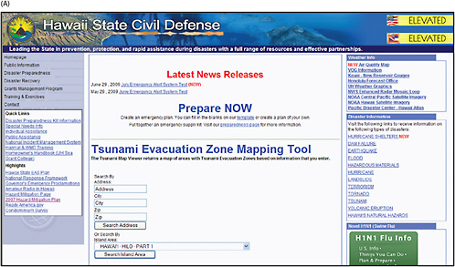
FIGURE D.1 Tsunami evacuation maps available at (A) Hawaii State Civil Defense for Hawaiian communities and (B; next page) Oregon Department of Geology and Mineral Industries for Oregon communities. SOURCE: http://www.scd.state.hi.us; with permission from Hawaii State Civil Defense, and http://www.oregongeology.org/sub/default.htm; image courtesy of DOGAMI, respectively.
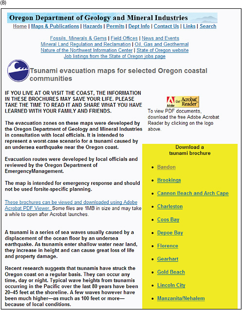
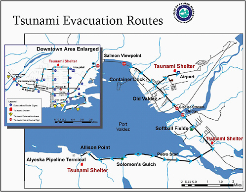
FIGURE D.2 Tsunami evacuation map for Valdez, Alaska. SOURCE: http://www.ci.valdez.ak.us/development/documents/TsunamiBrochureValdez.pdf; with permission from Lisa Von Bargen, City of Valdez.
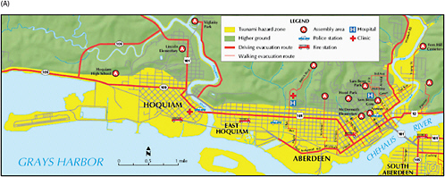
FIGURE D.3 Tsunami evacuation maps for (A) Aberdeen and Hoquiam, Washington, SOURCE: with permission from Washington Department of Natural Resources, Division of Geology and Earth Resources, (B) Seaside, Oregon, SOURCE: http://www.oregongeology.org/sub/default.htm; image courtesy of DOGAMI, (C) Mayaguez, Puerto Rico, SOURCE: http://redsismica.uprm.edu/spanish/Noticias/TsunamiMap_Pub.pdf; with permission from Puerto Rico Seismic Network Tsunami and Educational Outreach Program, and (D) Hilo, Hawaii, SOURCE: http://www.pdc.org/Disaster-Info/Shelters/CDmaps/HawaiiCounty/H-map01.html; with permission from Kevin Richards; Hawaii State Civil Defense.
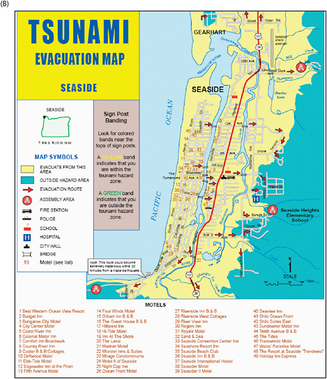
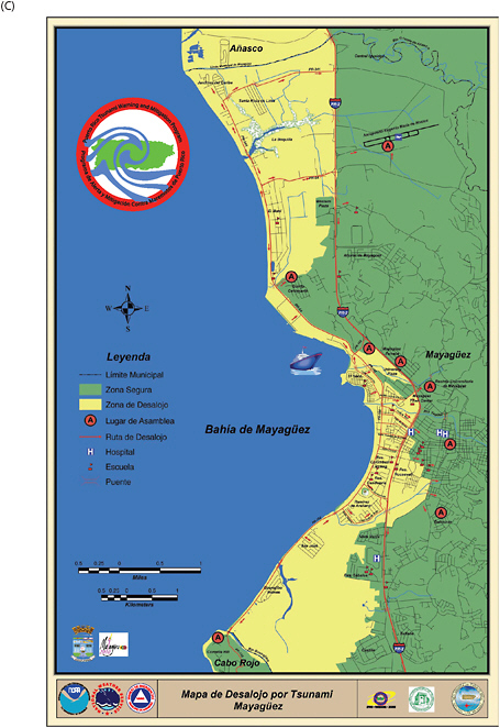
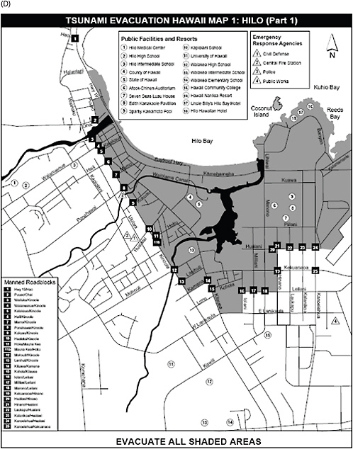
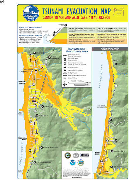
FIGURE D.4 (A) Tsunami evacuation map of Cannon Beach and Arch Cape areas, Oregon and (B) text included in evacuation map brochure for helping individuals to prepare for two types of tsunamis on the Oregon coast. SOURCE: http://www.oregongeology.org/sub/default.htm; image courtesy of DOGAMI.
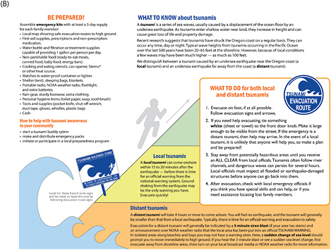
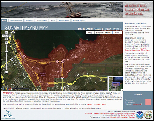
FIGURE D.5 Dynamic tsunami evacuation maps for Hawaiian communities served by an online mapping application. SOURCE: http://www.csc.noaa.gov/psc/riskmgmt/tsunami.html; Pacific Services Center, NOAA.


