4
Rationale for Focusing on the Arctic Ocean Basin and its Margins
Our knowledge of the earth beneath the circum-arctic landmasses is significantly greater than our knowledge of the Arctic Ocean Basin. As a result, we have insufficient scientific understanding to address confidently such national goals and societal concerns as global climatic change, nonrenewable mineral resources in the Arctic, and coastal and offshore management in the Arctic. The disparity in data and the consequent need to focus the next stage of arctic solid-earth geoscience on the Arctic Ocean Basin are illustrated by comparing current levels of data in the circum-arctic landmasses and the Arctic Ocean Basin.
Topographic maps at reconnaissance scales (1:500,000 or 1:250,000) are available for all the arctic landmasses, and large areas of the North American and Eurasian Arctic are covered by detailed topographic maps (scales 1:100,000 or larger). In contrast, only a few continental shelf areas have been mapped at scales of 1:250,000 or larger offshore (see Figure 4). Except in a few coastal areas, there is no organized effort to map systematically the bathymetry of the Arctic Ocean Basin, aside from classified efforts on behalf of the naval forces of the major powers. Long-range side-scan sonar acoustic backscattering images (sonographs) of the seafloor, of great utility for morphologic, structural, and sedimentologic studies of the ocean basins, have been obtained for the entire Exclusive Economic Zone of the United States except for the Arctic (Bering Sea EEZ-SCAN scientific staff, 1991).
The contrast between geological and geophysical mapping of the arctic landmasses and the Arctic Ocean Basin is also great. Onshore, national surveys have completed generalized geological maps of all the arctic lands, and active programs are under way to complete systematic coverage at the intermediate scale of 1:250,000. In Fennoscandia, the USSR, and Alaska, intermediate-scale mapping is either completed or nearly so, and more than one-half the Canadian Arctic lands have been mapped at this scale (see Figure 5). Local geological and geophysical mapping at large scales (1:100,000 or larger) and numerous oil and gas test wells have produced abundant detailed information in many areas of the onshore Arctic. Most onshore sedimentary basins of Arctic Alaska and Canada and the adjacent continental shelves as far north as Banks Island have been explored by reconnaissance or detailed networks of multichannel seismic reflection profiles obtained by both governmental and private organizations. The same holds true for the European Arctic, the arctic areas of the West Siberian Lowland, and the continental shelves in the southern Barents and Kara Seas. In addition, academic institutions and both private and governmental organizations involved in natural resource exploration are engaged in special-purpose mapping and topical geologic and geophysical studies at numerous onshore sites in the Arctic, and they have conducted extensive geologic and geophysical mapping and prospecting in areas where bedrock is exposed.
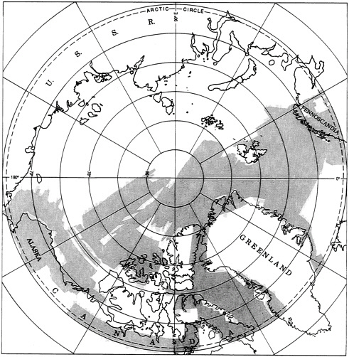
FIGURE 4 Recent status of published topographic and bathymetric mapping in the Arctic Ocean region. Topographic mapping (darker shading) is at scales of 1:250,000 or larger; bathymetric mapping (lighter shading) is at scales of 1:500,000 or larger. (Data from Parry and Perkins, 1988; and national topographic, hydrographic, and geological surveys of the arctic nations.)
Beyond the continental shelves, definitive information on pre-Neogene bedrock in the Arctic Ocean Basin comes from only seven piston cores and one dredge sample. Detailed seismic reflection surveys, from which detailed geological maps can be drawn, are restricted to the continental shelves of Alaska and the eastern Canadian Beaufort Sea. Almost everywhere else in the basin, seismic reflection data consist only of widely scattered single-channel profiles of poor quality and erratic geometry obtained from drifting ice. Exceptions are a multichannel reflection profile collected from ice floes in Fram Strait, several multichannel seismic reflection profiles in the southeast Canada Basin, and about 150 km of single-channel profiles collected from an icebreaker over Northwind Ridge. The disparity in seismic refraction data is not as great, but the offshore data base is still meager. Several high-quality crustal seismic refraction profiles have been collected on the mainland and continental shelves of the North American Arctic, and
FIGURE 5 Recent status of onshore geologic mapping in the Arctic Ocean region. Mapping at scales of 1:250,000 or larger (darker shading) and of offshore seismic reflection surveys with line spacings not exceeding 20 km (lighter shading). (Data from Hall, 1973; Weber, 1979; Jackson et al., 1985; and national geologic surveys of arctic nations.)
the acquisition of additional lines is planned. In the Arctic Ocean Basin, several refraction lines have been shot from sea ice, but they are widely scattered, and they are of variable quality as a result of adverse field conditions.
Except for Greenland, most of North America and Europe have been covered by regional gravity surveys and about one-half this area by regional low-level aeromagnetic surveys (see Figures 6 and 7). Offshore, publicly available aeromagnetic coverage has been obtained over most of the Arctic Ocean Basin west of a line between Point Barrow and Franz Josef Land by U.S. and Canadian organizations, and generalized anomaly maps have been constructed for the Arctic from magnetic data collected by the National Aeronautics and Space Administration's Polar Orbiting Geophysical Observatory and by its magnetic satellite. Most of the aeromagnetic lines are too widely spaced, however, to address the important structural and plate tectonic questions of the Arctic. Further, navigation errors were much larger in these vintage data than
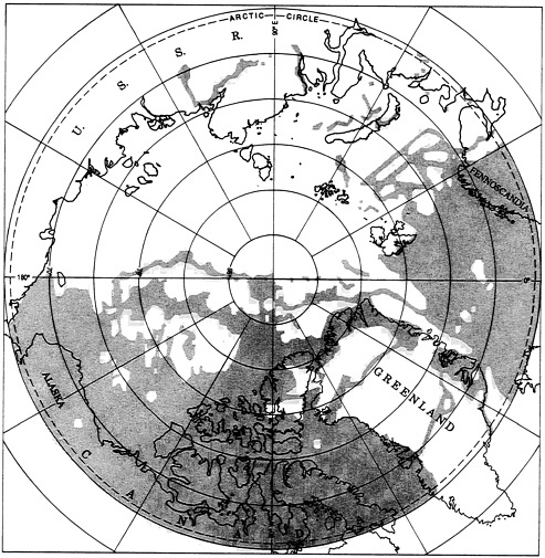
FIGURE 6 Recent status of gravity field surveys in the Arctic Ocean region at scales of 1:250,000 or larger or with data-point spacing not exceeding 30 km. (Data from Sobczak et al., 1990b.)
would result from modern Global Positioning System (GPS) navigation. More closely spaced coverage exists over the Beaufort and Chukchi Shelves and the southern part of the adjacent Northwind Ridge in the North American Arctic, but it is proprietary. Gravity data in the public domain in the Arctic Ocean Basin consists of a 10-km grid of gravity readings from ice floes in the Canadian Beaufort Sea, measurements from several drifting ice stations, some aircraft landings on ice floes, and a few icebreaker tracks.
In view of the present need for more definitive understanding of the character, environmental history, and geologic processes of the solid earth in the Arctic Ocean Basin and the disparity between our knowledge of the physiography, geology, and geophysics of the solid earth in the circum-arctic landmasses and the Arctic Ocean Basin, the committee recommends that the next expansion of effort in solid-earth geoscience in the Arctic focus on the Arctic Ocean Basin. This region offers the most significant scientific challenges and a greater potential for major scientific breakthroughs of global significance.