
2
Physiography
The Arctic consists of a ring of mainly mountainous continental landmasses that surround a small but bathymetrically complex sea, the Arctic Ocean (see Figure 2). Although the surrounding mountains are of only low to moderate heights, continental and mountain glaciation and extreme physical weathering have sculptured a rugged landscape.
Deeply eroded orogenic belts, sedimentary basins of diverse Phanerozoic and Precambrian ages, and prograded continental shelf and slope deposits underlie the coastal plains and continental shelves that fringe the Arctic Ocean Basin (Okulitch et al., 1989; Grantz et al., 1990a). The shelves, which include some of the widest and narrowest on Earth, owe their low relief to glacial erosion as well as to the more common processes of marine abrasion and progradational clastic sedimentation. Islands on the outer Barents-Kara Shelf and on the Laptev-East Siberian-Chukchi Shelf are at present our principal source of geologic framework and history of these broad continental shelves.
A complex of ridges, small basins of oceanic depth, and an active spreading center that is propagating into the Eurasian continent comprise the deep Arctic Ocean Basin, which lies at the heart of the north polar region (Perry and Fleming, 1986; Johnson et al., 1990). The basin is divided by the Lomonosov Ridge into the younger and deeper Eurasia Basin and the older and larger Amerasia Basin. The Lomonosov Ridge is a narrow sliver of continental crust 1,700 km long and 50–150 km wide that extends across the entire Arctic Ocean Basin. Most of its crest lies 2,000 m to 500 m below sea level, and the ridge therefore exerts a major influence on Arctic Ocean Basin oceanography.
Broad areas of the Eurasia Basin are more than 4,000 m deep, and small, isolated basins along the axis of the spreading Arctic Mid-Ocean Ridge are deeper than 5,000 m. The Amerasia Basin is divided by the Alpha Ridge into the Makarov Basin to the north and the Canada Basin to the south. Both basins reach maximum depths of almost 4,000 m. The Alpha Ridge, which is thought to be underlain by volcanic rocks, is 600 km wide and 1,000 km long and has crustal depths of 1,100 m to 2,000 m below sea level. Near 84°N, 180°W, it joins the Mendeleev Ridge, which is also bathymetrically complex but somewhat deeper, at right angles. Summit elevations on the Mendeleev Ridge lie 1,500 to 2,500 m below sea level. Near 79°N, the Mendeleev Ridge merges with the north-trending, flat-topped Arlis Ridge, the westernmost of a group of morphologically similar ridges and plateaus that form the Chukchi Continental Border-
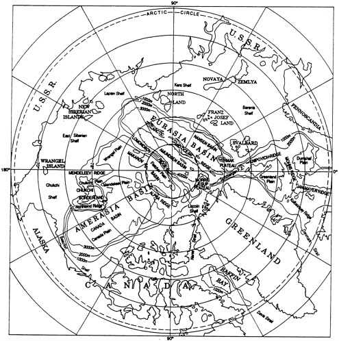
FIGURE 2 Principal geographic and physiographic features of the Arctic Ocean region (from Perry and Fleming, 1986).
land. Ridge and plateau summits in the borderland are subhorizontal or gently sloping and lie mostly between 280 m and 1,500 m below sea level. Small, deep northerly-trending basins that lie between the ridges are included in the borderland. The morphology of the ridges and plateaus of the borderland permits the interpretation that the ridges are continental fragments, but definitive data are lacking.


