
3
Modeling Transport Processes in the Coastal Ocean
Alan F. Blumberg
Hydroqual, Incorporated
Richard P. Signell, Harry L. Jenter
U.S. Geological Survey
INTRODUCTION
As population growth and industrial development continue along the coastal zones, nearshore waters over the continental shelf are being subjected to increasing environmental stresses from numerous sources. Discharges of municipal and industrial wastes, agricultural runoff, combined sewer overflows, and waste spills of potentially toxic substances from coastal commerce contribute collectively to a host of water-quality problems. The eventual impact of these discharges is the result of complex interactions among the pollutant inputs from all sources; the various chemical forms of the constituents present in the water column and their associated chemical reactions with each other; and the complex marine food chains, which can exchange nutrients and other chemicals between the water column and the underlying sediment. To understand all of these interactions, it is necessary to define the hydrodynamic transport processes governing the movement and mixing of the constituents as they are forced by various hydrographical (runoff, estuarine circulation), meteorological (surface wind, heat fluxes), open ocean (large-scale ocean circulation), astronomical (tides), and internal (density gradients) mechanisms.
The circulation occurring over the continental shelf typically exhibits considerable temporal and spatial variability. It is characterized by relatively large-scale alongshore current systems, which have a variety of interannual, seasonal, and daily variations. The variability in circulation from place to place is evident in satellite sea-surface temperature images that show patchy upwelling zones, filaments of cold water extending offshore, rotating eddies, and other large-scale circulation features. Processes responsible for the circulation are wind-driven currents and mixing, which are often the dominant processes over the shelf; buoyancy effects, which lead to plume and frontal formations; shelf-open ocean interactions, where meandering offshore currents and mesoscale eddies can entrain much water from the shelf; and tidal resonances, which can produce large tidal currents and intense levels of vertical mixing.
Observational programs have been the cornerstone of our conceptual and theoretical understanding of currents and water properties in coastal regions. Our knowledge has increased because of the
introduction of moored, hydrographic, Lagrangian, and satellite-based observations. However, to permit a consistent view of the circulation, all of these types of observations are needed simultaneously. Consider, for example, that in many coastal regions the length scales of the hydrodynamical processes are characterized by an internal deformation radius (Rossby radius) of 5 km to 15 km and by topographic variations ranging from 1 km to 10 km. Motions and water properties measured at stations separated by distances much greater than the length of these scales will, in general, tend to be only loosely related to one another. The sampling networks of hydrographic surveys and current meter moorings must be chosen within the Rossby radius. For coastal domains of small extent, this is possible; however, for large regions it is not always feasible. There are also a host of issues associated with obtaining observations with the proper time scales. Satellites provide excellent spatial views that are, unfortunately, only snapshots in time. Current meters are better at addressing temporal variability, since they employ sampling frequencies that are typically 30 minutes or less; however, their spatial coverage is limited. It is apparent, then, that observational programs are rarely sufficiently dense (with respect to frequency of observation) in either space or time to provide an adequate description of the water mass and velocity fields of an evolving, three-dimensional piece of coastal ocean.
In recent years, coastal-ocean circulation models have come to be depended upon, when properly tested and verified, to synthesize information from measurements and provide a framework for investigating the basic processes of a region. As such, coastal-ocean models play a critical role in determining how nutrients, sediment, contaminants, and other water-borne materials are transported.
The purpose of this paper is to provide an overview of the processes governing the transport of water, dissolved substances, and particles in the context of the design and development of a three-dimensional circulation model of Massachusetts Bay. The bay is ideally suited for the purposes of this paper because its circulation is a complicated function of winds, tides, and river inflows, and because its environmental problems, caused by the introduction of wastes over many years, are typical of those found off many large metropolitan areas. Before the presentation of the Massachusetts Bay case study, a short discussion of numerical models themselves will be provided, briefly reviewing where coastal-ocean circulation modeling is today and describing the physically comprehensive circulation model developed by Blumberg and Mellor (1980) which will be used to elucidate the various transport processes in Massachusetts Bay. In the final section, some thoughts on the important issues of coastal-ocean modeling that need to be addressed in the future will be put forth.
COASTAL-CIRCULATION MODELING
Significant progress has been made in the development of limited-area coastal-circulation models. The state of the science has progressed to the point where programs to develop and validate a predictive system for the U.S. coastal ocean are being proposed (Joint Oceanographic, Inc., 1990). There are now models being used routinely in the Great Lakes to determine water levels, currents, and temperatures for periods going back 30 years (Bedford and Schwab, 1990). Much of the increase in modeling activities is due to the availability of low cost, supercomputer resources and the continued
development of reliable numerical codes. Too many models exist to provide a comprehensive survey here. The interested reader is referred to the monographs by Heaps (1986) and Nihoul and Jamart (1987) and to the review articles by Wang et al. (1990) and Blumberg and Oey (1985) for details concerning the status of coastal ocean circulation modeling.
The coastal-ocean-circulation model developed by Blumberg and Mellor (1980), called ECOM3D, will be used as a framework for discussing the transport processes that operate in the coastal ocean. The model is three-dimensional and time dependent so that it can reproduce the complex oceanographic physics present over the shelf. Evolving water masses, baroclinic plumes, fronts, and eddies are accounted for by prognostic equations for the thermodynamic quantities, temperature, and salinity. Free surface elevation is also calculated prognostically so that tides and storm-surge events can be simulated. Through these prognostic equations and the use of the full, nonlinear form of the momentum equations, the processes relevant to a spectrum of nonlinear, stratified flows can be properly modeled. Coastal upwelling dynamics and the processes leading to stratified tidal rectification will be part of the simulated distributions. The vertical turbulent mixing processes are parameterized using the turbulent-closure submodel of Mellor and Yamada (1982). This submodel contains non-dimensional empirical constants that are fixed by reference to laboratory data and are independent of particular hydrodynamic model applications. ECOM3D also incorporates a s-coordinate system such that the number of grid points in the vertical is independent of depth. This ensures that the dynamically important surface and bottom boundary layers across an entire sloping shelf can be adequately resolved. The last model feature to note is the use of a curvilinear coordinate system. This system greatly increases model efficiency in treating irregularly shaped coastlines and in meeting requirements for high resolution in specific local regions. A complete description of the governing equations and numerical techniques can be found in Blumberg and Mellor (1987). The model has been used in over 30 studies, which have appeared in the referred literature, and is being exercised in an operational forecasting mode for the Great Lakes and in Norwegian coastal waters.
A CASE STUDY: MASSACHUSETTS BAY
Massachusetts Bay and Cape Cod Bay combine to form a roughly 100 km × 50 km semi-enclosed basin with an average depth of 35 m located in the western Gulf of Maine (Figure 3.1). As in many coastal regions near major urban areas, the bays are used for a variety of purposes: commercial and recreational fishing, shipping, recreational boating, swimming, and as a repository for sewage effluent and dredged sediments. Currently, there is considerable controversy concerning the extension of the Boston sewage outfall pipe from the mouth of Boston Harbor to a site 9 miles offshore. The public living around the coast of Massachusetts Bay and Cape Cod Bay is concerned that Boston is improving its pollution problem at the expense of the bays and that swimming beaches, shellfish beds, fishing resources, and the endangered right whale population that feeds in the bays may be jeopardized. To address these concerns, ECOM3D is being used in conjunction with available observations to determine the fate and transport of contaminants, nutrients, and other water-borne materials in the bays, including effluent from the proposed outfall site. The region covered by the model encompasses
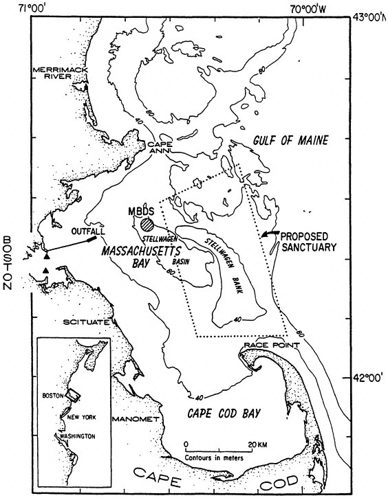
FIGURE 3.1 Bathymetric mapshowing Massachusetts and Cape Cod Bays, present sewage outfalls in Boston Harbor (solid triangles), location of new ocean outfall for treated Boston sewage in western Massachusetts Bay (average flow about 20 m3/s), approximate boundary of the proposed Stellwagen Bank Marine Sanctuary, and the Massachusetts Bay Disposal Site (MBDS).
all of Massachusetts Bay and Cape Cod Bay as well as Stellwagen Bank (Figure 3.2). It includes the Merrimack River and extends offshore to a depth of about 200 m. The resolution of the curvilinear grid system ranges from a minimum of 600 m near the proposed outfall site to a maximum of 6000 m near the open-ocean boundary. Vertical resolution is accomplished by using 10 a-levels in the water column. Data for model calibration and verification was obtained during an intensive field program over the period from 1990 to 1991 (Geyer et al., 1992).
Tidal Currents
The most predictable, and often the strongest, currents in the bays are produced by the barotropic tides, which have an average range of 2.6 m. Tides are introduced into the model by forcing the open offshore boundaries with sea surface elevation data from a well-calibrated, lower-resolution Gulf of Maine model (Naimie and Lynch, 1991). Comparison of modeled currents with moored-current observations from the winter (when the best analysis of the pure tidal signal can be made) reveals that both tidal excursions and orientations of tidal ellipses are reproduced well (Figure 3.3). Tidal excursions range from more that 12 km (off Provincetown and in Boston Harbor) to less than 2 km (in the deep central Massachusetts Bay). The tidal excursion at the proposed outfall is 2 km.
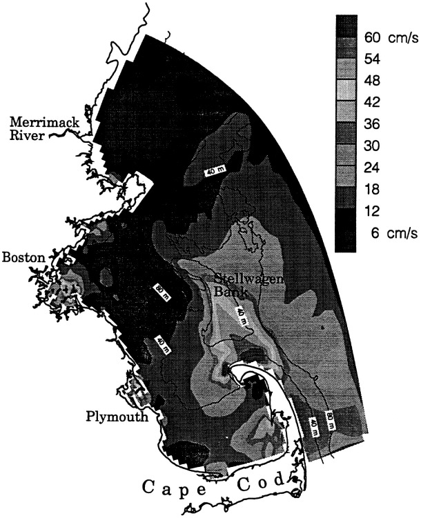
While the moored observations of tidal currents give some indication of the spatial variation, the model, verified at the moorings, can fill in the spatial structure. It indicates regions of strong tidal gradients where tidal mixing fronts may form as well as features unresolved by the observations (Figure 3.4). The locations of the strong gradients on Stellwagen Bank and west of Provincetown are near regions frequented by the endangered North Atlantic right whale (Hamilton and Mayo, 1988). Therefore, resolution of the flow in these regions may be important in determining the effects of pollution introduced into the bays on the whale population.
Because of their strength, tides play an important role in vertical mixing processes, but since they are periodic at 12.4 hours (the M2 constituent dominates here), they essentially displace material back and forth over the length of the tidal excursion with little net transport. The exceptions are when tidal currents act in conjunction with the bottom topography and coastline geometry to produce strong asymmetry between ebb and flood. The tides have a large effect on the flushing of Boston Harbor (Signell and Butman, 1992) and may be important locally at the tip of Cape Cod and along the western side of Stellwagen Bank, but they have little impact on transporting material over distances comparable to the size of the bays.
Subtidal Currents
Observations suggest that horizontal transport of material is accomplished by advection due to the mean flow through the bays and the dispersive effect of subtidal wind-driven and river-runoff events. The mean flow generally supports the historical conceptual picture of a counterclockwise circulation (Bigelow, 1927; Bumpus and Lauzier, 1965; Brooks, 1985) made up of southwesterly inflow south
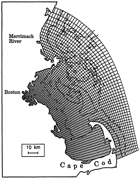
FIGURE 3.2 Model grid for the three-dimensional circulation model, ECOM3D, of Massachusetts Bay and Cape Cod Bay. The curvilinear orthogonal grid allows the mesh resolution to vary spatially, having a minimum grid spacing of 600 m and a maximum spacing of 6000 m. The grid spacing in the vicinity of the proposed outfall is roughly 1000 m. There are currently 10 vertical o-levels in the model, evenly spaced throughout the water column.
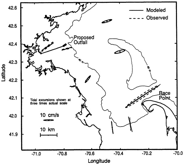
FIGURE 3.3 Comparison of modeled and observed surface M2 barotropic tidal currents in Massachusetts Bay. Shown are tidal ellipses, which indicate the observed velocities over the tidal cycle. They also represent the excursions water parcels would make if they moved with the tidal currents observed at the mooring. For clarity these tidal excursions are shown at three times actualscale. Tidal excursions are nearly 10 km off Race Point but only 2 km near the location of the proposed outfall.
of Cape Ann, southerly flow along the coast east of Scituate, and northeasterly outflow north of Race Point (Figure 3.5). This mean circulation pattern, however, is often altered by wind and runoff events, and except at the deep stations near Cape Ann and Race Point, the fluctuations are typically stronger than the mean. The proposed outfall site, in fact, is in a region of weak mean flow, west of the stronger residual current system. This means that material here is mixed and transported by random fluctuations of wind and runoff events rather than being swept away by a persistent current. Using process-oriented modeling that examines the bays' response to specified forcing conditions, the factors that are important for driving the mean flow and the low-frequency fluctuations can be determined.
Mean Flow
What drives the observed counterclockwise flow through the bays? One hypothesis is that it is simply an extension of the coastal current that exists in the Gulf of Maine (Bigelow, 1927; Bumpus and Lauzier, 1965; Vermersch et al., 1979). To test this hypothesis, the model is forced with a 3-cm offshore sea-surface slope from the coast to the 100-m isobath along the northern boundary. This slope produces a 10-cm/s coastal current north of Cape Ann that is comparable to observed coastal current speeds (Vermersch, 1979). The simulation reveals that much of the Gulf of Maine coastal current moves southward following the bathymetry along the eastern flank of Stellwagen Bank, largely bypassing the bays (Figure 3.6). The coastal current explains the observed mean flow southeast of Cape Ann and at Stellwagen Bank (stations U2, U3 and U6 in Figure 3.5), but the counterclockwise flow that the coastal current drives in the bays is much weaker than observed. Adding the mean wind stress of 1 dyne/cm2 to the coastal current forcing dramatically changes the simulation of the mean flow. The mean wind is from the west and drives a realistic, simulated southeastward current along the coast from Boston to Cape Cod, which exits the bays at Race Point (Figure 3.7). Thus, remote forcing from the Gulf of Maine coastal current and the mean wind stress both play important roles in explaining the mean circulation in the bays.
Low-Frequency Fluctuations
The wind direction is one factor that determines the response of the bays: northwest or southeast winds are aligned with the long-axis of the bays and are therefore more efficient at driving circulation than southwest or northeast winds (Geyer et al., 1992). When the waters of the bays are unstratified, as in winter, northwest winds drive strong flow downwind at the coast, which piles up water in Cape Cod Bay, creating an along-bay pressure gradient (Figure 3.8). This pressure gradient drives return flow against the wind at depth (Figure 3.9). When the wind blows from the southwest during well-mixed conditions, the currents are substantially weaker (Figure 3.10).
Another factor that has a major impact on the wind response is the degree of stratification. Results from two years of measurements near the proposed outfall show that the surface current fluctuations
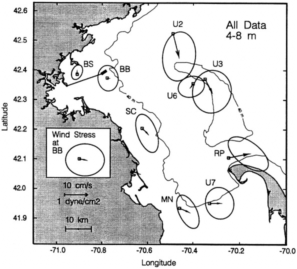
FIGURE 3.5 Map showing the mean flow (solid arrow) and the low-frequency variability (shown as ellipses centered around the tip of the mean flow) for all near-surface (4-8 m depth) current measurements made from December 1989 to September 1991. The daily averaged current originates at the station symbol (two-character names) and flows toward any location within the ellipse. The arrows and ellipses have been scaled to correspond to the distance a particle moving with that current would travel in one day.
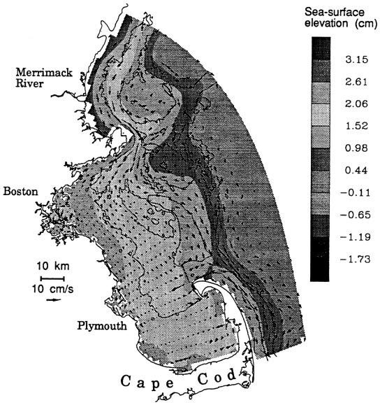
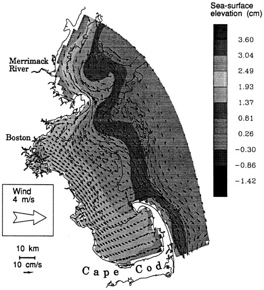
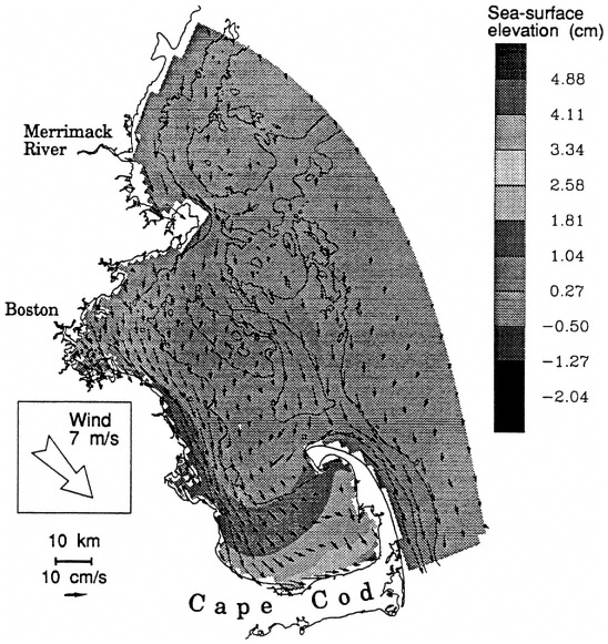
FIGURE 3.8 Modeled surface current and elevation response to a wind stress from the northwest of 1 dyne/cm2 (about 7 m/s) in well-mixed conditions. This along-bay wind drives strong flow downwind in the shallow water near the coast. The convergence of surface water along the northern shore of Cape Cod indicates the presence of strong downwelling.
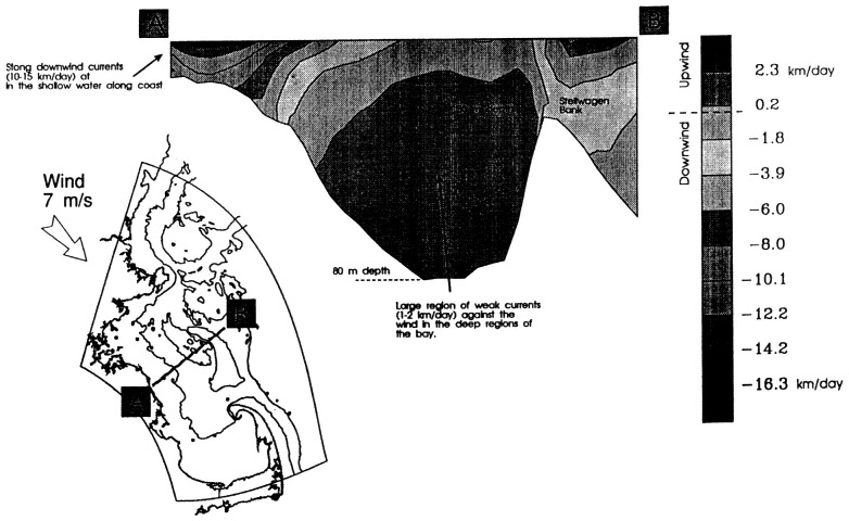
FIGURE 3.9 Vertical section of along-bay current response to wind stress from the northwest of 1 dyne/cm2 (about 7 m/s) in well-mixed conditions. The along-bay wind drives downwind currents of 10-15 cm/s in the shallow water near the coast. The downwind current establishes an opposing pressure gradient, which drives a weak return flow (1-2 cm/s) at depth.
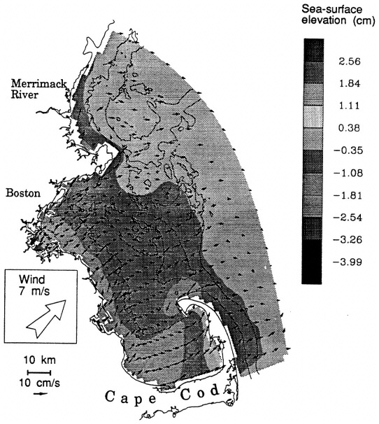
FIGURE 3.10 Modeled surface current and elevation response to a wind stress from the southwest of 1 dyne/cm2 (about 7 m/s) in well-mixed conditions. The cross-bay wind drives downwind surface flow of nearly the same magnitude over most of the Massachusetts Bays. The currents near the coast are significantly weaker than those generated by the along-bay wind shown on Figure 3.8.
are strongest in summer, when the wind-stress fluctuations are weakest (Figure 3.11). One hypothesis regarding this is that the wind stress is more efficient at driving surface currents in summer, when strong stratification reduces the frictional resistance of the surface layer. Modeling the response of the bays to southwest wind under stratified conditions (Figure 3.12) reveals a much different picture than the unstratified case (Figure 3.10). The surface currents are often twice as large, and the circulation pattern is dramatically different. As the water moves offshore along the coast north of Boston, cold nutrient-rich water is upwelled, as evident in the model, as well as in remotely sensed images of sea-surface temperature (Figure 3.13). Being able to model this type of response is especially important for understanding the proposed outfall's impact, as the outfall plume may be trapped in the cold, light-limited, deeper waters until it is upwelled.
Although the Massachusetts bays do not have any large rivers that discharge directly into them, the Merrimack River just to the north of Cape Ann plays an important role in driving their circulation, especially in the spring (Butman, 1975). In the absence of wind, fresh water discharged from the river mouth forms a surface plume that turns to the right and follows the coast in the northern hemisphere. Thus the Merrimack and other Gulf of Maine rivers combine to generate a buoyancy-driven coastal current that flows southward off Cape Ann. Large river runoff events can drive currents with magnitudes of 20-40 cm/s in the bays, which are magnitudes comparable to those during strong wind events.
Wind and river effects often interact nonlinearly, generating extremely complex flow patterns, even for fairly simple forcing functions. As an example, turning on the Merrimack River under the influence of a mean wind from the west gives rise to lateral and vertical salinity gradients that act with the wind and local topography to yield small-scale lateral eddying structures in western Massachusetts Bay that change markedly with time and position in the water column (Figure 3.14). This illustrates the difficulty with isolating different forcing mechanisms from field data. Often, the mechanisms cannot be linearly superimposed. Numerical models frequently become the only viable mechanism for analyzing the transport of material when this is the case.
Outfall Plume Dynamics
Because of the complicated nature of the circulation in embayments such as the one considered here, it is difficult to make simple calculations based on observations regarding the transport of material suspended or dissolved in the water column. In particular, it is clear that realistically modeling the effluent plume from the proposed outfall requires a three-dimensional model that actively couples the density field with the circulation. Because the plume is buoyant and may enter a stratified system, the model must have the ability to allow the effluent to become trapped below the thermocline or to rise to the surface as determined by the ambient stratification.
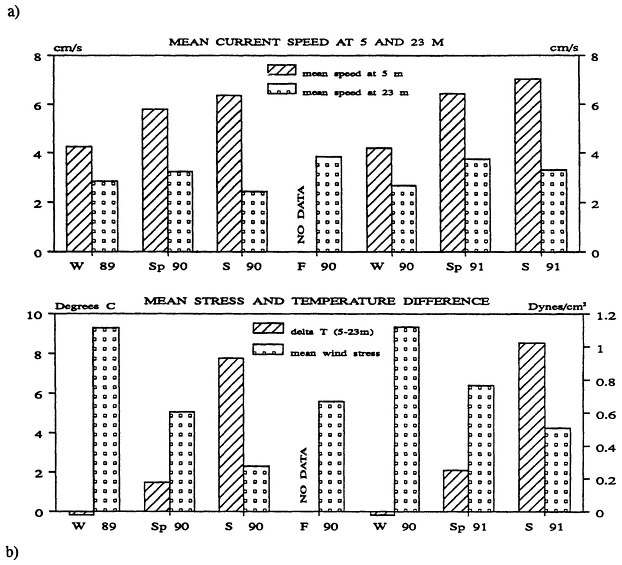
FIGURE 3.11 a) Mean daily vector-averaged current speed at Station BB (Figure 3.5) at 5-m and 23-m water depth (winter, November through February; spring, March through May; summer, June through August;fall, September and October). b) Mean daily averaged wind stress amplitude at the Large Navigational Buoy and temperature difference between 5-m and 23-m water depth. These data suggests that stratification is more important than wind in determining the strength of the near-surface current at the new outfall site.
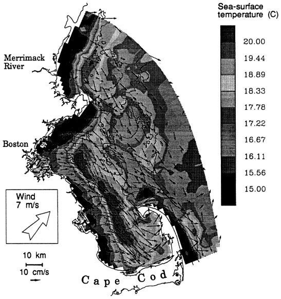
FIGURE 3.12 Modeled surface current and sea-surface temperature respond to a wind stress from the southwest of 1 dyne/cm2 (about 7 m/s) in stratified conditions. From a homogeneous state, the model was run with M2 tides and a surface heat flux of 100 W/m2 for 12 days. The wind was imposed for the last two days of the simulations. The wind-induced Upwelling brings cold, nutrient-rich water from depth to the surface and plays an important role in primary production.
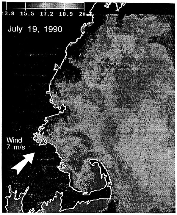
FIGURE 3.13 Observed sea-surface temperature during a typical summer upwelling event, at 0600 on July 19, 1990. On the preceding two days, the wind was relatively constant at a speed of about 7 m/s from the southwest. The observed surface-temperature patterns are quite similar to the modeled upwelling event, especially along the coast as shown in Figure 12.
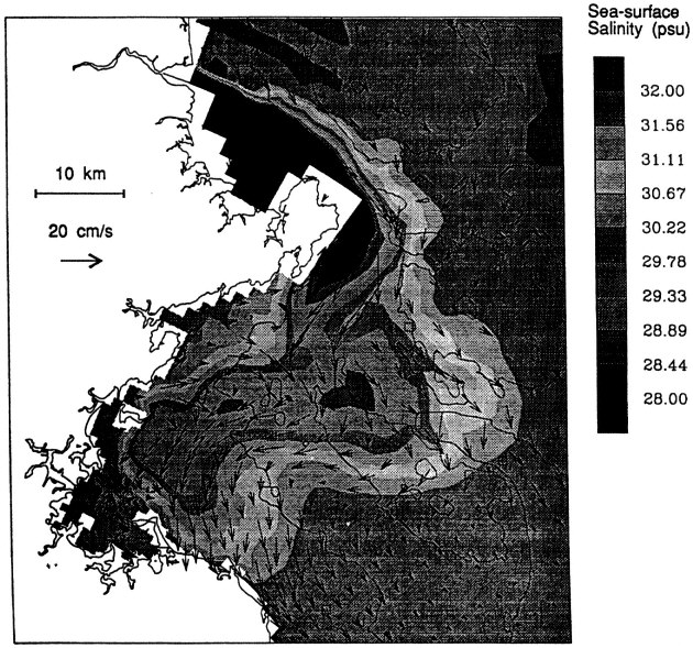
FIGURE 3.14 Modeled surface-current and salinity response of western Massachusetts Bay to a runoff event from the Merrimack River. The Merrimack was turned on with a flow of 500 m3/s, a magnitude typical of a spring freshet (Geyer, 1992), and shown is the result after 8 days. The runoff event creates strong and complex currents in the vicinity of the proposed outfall site, which would be difficult to resolve with moored instruments.
This is critical, as the surfaces above and below the thermocline are often moving in opposite directions. Consider the movement of a plume produced through the discharge of 15 m3/s of fresh water into a well-mixed Massachusetts Bay with a salinity of 32 psu. A steady wind stress of I dyne/cm2 (about 7 m/s) yields the flow patterns shown in Figures 3.8 and 3.9 and also causes a complex plume structure (Figure 3.15). As the plume rises to the surface, it is advected northwestward by the bottom currents. However, as the plume approaches the surface, it is advected with the oppositely directed surface currents to the southeast.
FUTURE DIRECTIONS AND CONCLUDING REMARKS
Our knowledge of the processes affecting the movement and mixing of water masses, various chemical constituents, and particles and our ability to model them numerically has expanded considerably in the past five years. Hydrodynamic models of the coastal ocean have become indispensable aids in decision making relating to wasteload allocations from point sources of pollution and to the design and licensing of offshore structures. The models typically are at their best in predicting phenomena related to the tides and to the response of the waters to local forcing conditions. However, strict attention must be given to the adequacy of the model grid-spacing, because experience has shown that when the model resolution is commensurate with the physical process of a region, the model simulations agree best with the observations.
It must be mentioned that the most critical factor limiting the development of truly predictive models is an understanding of the complex interaction between the coastal waters and those of the offshore ocean. Typically, coastal ocean models cover a limited region along the coast with their offshore extent ending at the continental shelf break. At this edge, it is necessary to introduce a boundary condition that properly parameterizes the influences of the ocean exterior to the coastal region being modeled. The use of both high-quality data sets and specially designed numerical model experiments are needed to determine the proper feedbacks between the two regions.
Advances in computer power and speed have recently made it feasible to construct and apply time— varying, three-dimensional hydrodynamic models. This type of modeling, while feasible, is computationally intensive and puts severe constraints on the resources available for engineering analyses. What is needed are models that include all the important physical, chemical, and biological processes yet can be used in a time effective manner without significantly depleting the available computer resources. One approach to this problem is through the development of a hydrodynamic and water-quality-model interfacing methodology to produce time averaged, residual transports of coarse spatial resolution from an intratidal hydrodynamic model of high spatial resolution. These time and space averaged mass transport quantities should be sufficient to drive appropriate segmented water-quality models without loss of accuracy.
Finally, there is a need to make better use of available observations. Models require data to establish interior and boundary conditions, to update boundary fields, to validate the model physics, and to verify the simulations. Current, temperature, and salinity data are often insufficient for an unambiguous model calibration/validation and one must look at how well the water-quality constituents
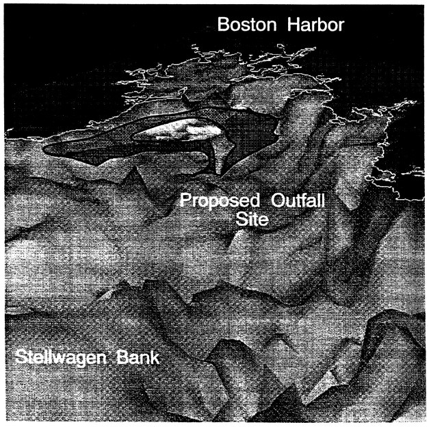
FIGURE 3.15 Three-dimensional view of the plume caused by a discharge of 15 m3 /s of fresh water at the proposed outfall site under well-mixed conditions. A wind stress of 1 dyne/cm2 (about 7 m/s) was applied from the west, and shown are dilution isosurfaces of 250 and 500 after 9 days of simulation. As the plume rises to the surface, it is pulled toward Boston by the bottom currents, but when it reaches the surface it moves with the surface currents and is transported along the coast toward Cape Cod
are being modeled to derive a sense of the validity of the modeled transport processes. One needs to blend the results from both circulation and water quality models with the available data to provide for the best estimates of how water and materials are transported throughout a coastal system. The data assimilation, that is, the process of this blending, is undoubtedly the most powerful tool presently available for extracting information and insight from the sparse coastal-ocean data sets and the imperfect model results.
ACKNOWLEDGEMENTS
This work has been funded by the Massachusetts Water Resources Authority through contracts with both HydroQual (Marine Technical Environmental Services Contract #37 to Normandeau Associates) and the U.S. Geological Survey. Additional support has been provided by the Massachusetts Environmental Trust, the U.S. Environmental Protection Agency's Massachusetts Bays Program, and the U.S. Geological Survey. The authors would like to thank Robert Beardsley for his role in motivating this paper. This paper also appears in the Journal of Marine Environmental Engineering, 1:31-52, 1993, published by Gordon and Breach, Reading, England.
REFERENCES
Bedford, K., and D. Schwab. 1990. Preparation of Real-Time Great Lakes Forecasts. CRAYCHANNELS, Cray., Res., Inc., p. 14-17.
Bigelow, H. B. 1927. Physical oceanography of the Gulf of Maine. Bull. U.S. Bur. Fish. 40(511):1027.
Blumberg, A. F., and G. L. Mellor. 1980. A coastal ocean numerical model. Pp. 203-214 in: Mathematical Modelling of Estuarine Physics, Proceedings of the International Symposium, Hamburg, 24-26 August 1987. Berlin: Springer-Verlag.
Blumberg, A. F., and G. L. Mellor. 1987. A description of a three-dimensional coastal ocean circulation model. Pp. 1-16 in: Three-Dimensional Coastal Ocean Models, Coastal and Estuarine Sciences, 4. Washington, D.C.: American Geophysical Union.
Blumberg, A. F., and L. Y. Oey. 1985. Modeling circulation and mixing in estuaries and coastal oceans. Pp. 525-547 in Advances in Geophysics, 28A.
Brooks, D. 1985. Vernal circulation in the Gulf of Maine. Journal of Geophysical Research.
Bumpus, D., and M. Lauzier. 1965. Circulation on the Continental Shelf of the East Coast of Eastern North America between Newfoundland and Florida. Washington, D.C.: American Geographical Society Serial Atlas of the Marine Environment, Folio 7.
Butman, B. 1975. On the Dynamics of Shallow Water Currents in Massachusetts Bay and the New England Continental Shelf Ph.D thesis, Massachusetts Institute of Technology and Woods Hole Oceanographic Institution.
Butman, B., M. Bothner, J. Hathaway, H. Jenter, H. Knebel, F. Manheim, and R. Signell. 1992. Contaminant Transport and Accumulation in Massachusetts Bay and Boston Harbor: A Summary of U.S. Geological Survey Studies. USGS Open-File Report 92-202.
Joint Oceanographic Inc. 1990. Coastal Ocean Prediction Systems Program. Available from Joint Oceanographic Inc., Suite 800, 1755 Massachusetts Avenue, NW, Washington DC 20036-2102.
Geyer, W., G. Gardner, W. Brown, J. Irish, B. Butman, T. Loder, and R. Signell. 1992. Physical Oceanographic Investigation of Massachusetts and Cape Cod Bays, Technical Report WHOI-92-x (in press), Woods Hole, Massachusetts: Woods Hole Oceanographic Institution.
Hamilton, P., and C. Mayo. 1988. Population characteristics of Right Whales (Eubal aena glacialis) observed in Cape Cod and Massachusetts Bays, 1978-1986. Rep. Int. Whal. Commn (Special Issue 12):203-208.
Heaps, N. S. 1986. Three-Dimensional Coastal Ocean Models, Coastal and Estuarine Sciences, 4, Washington, D.C. :American Geophysical Union.
Mellor, G. L., and T. Yamada. 1982. Development of a turbulence closure model for geophysical fluid problems. Rev. Geophys. Space Phys., 20:851-875.
Nihoul, J. C. J., and B. J. Jamart. 1987. Three-Dimensional models of Marine and Estuarine Dynamics. Amsterdam: Elsevier Scientific Publishing Co.
Naimie, C., and D. Lynch. 1991. Benchmark 3-D M2 and M2 Residual Tides for Georges Bank and the Gulf of Maine, Technical Report NML-91-2. Numerical Methods Laboratory, Thayer School of Engineering, Dartmouth College. Hanover, New Hampshire: Dartmouth College.
Signell, R. P., and B. Butman. 1992. Modeling tidal exchange and dispersion in Boston Harbor, accepted to Journal of Geophysical Research.
Wang, J. D., A. F. Blumberg, H. L. Butler, and P. Hamilton. 1990. Transport prediction in partially stratified tidal water. Journal of Hydraulic Engineering, 116:380-396.
Vermersch, J., R. Beardsley, and W. Brown. 1979. Winter circulation in the western Gulf of Maine: Part 2. Current and pressure observations. Journal of Phys. Oceanography 9: 786-784.


