
2
NOAA Environmental Satellite Programs.
NOAA operates two environmental satellite systems: the POES system and the GOES system. The two-satellite POES system observes the entire Earth at least four times per day; the two spacecraft of the GOES system provide continuous coverage of the contiguous 48 states, the southern part of Alaska, Hawaii, and adjacent ocean areas. These two systems provide data and communications in support of a variety of environmental and related programs, such as meteorology, oceanography, climate, hydrology, land use, and the space environment. The systems also support international search and rescue satellite-aided tracking (SARSAT), the broadcast of processed weather analyses and other environmental information via weather facsimile (WEFAX), and various direct broadcasts of data as they are collected by the satellites.1 This report focuses on elements of the POES and GOES systems that are of high priority in the current modernization of the NWS:
- multispectral imaging of the Earth's surface and atmosphere (including inferring the three-dimensional wind field where suitable clouds or water vapor patterns exist)
- sounding of the atmosphere to determine the three-dimensional distribution of its temperature and water vapor
Polar-Orbiting Operational Environmental Satellite System
The current POES evolved from the NASA launch of TIROS-1 on April 1, 1960 (Table 2-1). This first “weather satellite” was very crude compared to weather satellites today. TIROS-1 contained only two television cameras which were quite primitive by today's standards; the sensors, orbit, and stabilization of the spacecraft limited the coverage and utility of the images. TIROS-2 included the first scanning radiometer (SR), with five channels in the visible and infrared portions of the spectrum. TIROS-3 through TIROS-7, launched in 1961, 1962, and 1963, were intended to provide nearly daily observation of the Earth's cloud cover as viewed from space by satellite. The images were valuable in data-sparse areas, particularly for detecting and tracking tropical storms over the oceans. TIROS-8, launched in December 1963, was equipped with a new type of television camera for automatic picture transmission (APT) to relatively inexpensive ground stations within the line of sight of the satellite as it orbited the Earth. A significant advance in technology was implemented with the launch of TIROS-9 in January 1965. Coverage of the Earth was vastly improved by (1) increasing the orbit inclination from 48 to 58 degrees, which was used for earlier TIROS satellites, to 99 degrees (near-polar, sun-synchronous, circular orbit);2 and (2) introducing the “wheel” configuration, in which the spin axis of the satellite was maintained perpendicular to the orbit plane. The optical axes of the two wide-angle television cameras were oriented perpendicular to the spin axis (i.e., rotating within the orbit plane), and the shutters of the cameras operated only when the cameras were pointing directly at the Earth beneath. Thus, the sunlit part of the entire Earth could be viewed each day, about a fourfold increase in coverage over earlier TIROS satellites. TIROS-10, the last TIROS to be launched (July 1965), assured adequate coverage of tropical storms prior to the launch of the first series of operational weather satellites in 1966.
Beginning in the early 1960s, NASA developed the Nimbus polar-orbiting satellite as a test bed for new technology for possible use in the operational satellite program or for the collection of special observations for environmental
TABLE 2-1 TIROS Satellites
|
Name |
Launch Date |
Operating Life (days)a |
Orbit |
Features |
|
TIROS-1 |
1 Apr 60 |
89 |
Inclined |
2 TV cameras |
|
TIROS-2 |
23 Nov 60 |
376 |
Inclined |
2 TV cameras, SRb |
|
TIROS-3 |
12 Jul 61 |
230 |
Inclined |
2 TV cameras, SRb |
|
TIROS-4 |
8 Feb 62 |
161 |
Inclined |
1 TV camera, SRb |
|
TIROS-5 |
19 Jun 62 |
321 |
Inclined |
2 TV cameras |
|
TIROS-6 |
18 Sep 62 |
389 |
Inclined |
2 TV cameras |
|
TIROS-7 |
19 Jun 63 |
1,809 |
Inclined |
2 TV cameras, SRb |
|
TIROS-8 |
21 Dec 63 |
1,287 |
Inclined |
1 TV camera, APTc |
|
TIROS-9 |
22 Jan 65 |
1,238 |
Sun Synchd |
Global coverage, 2 TV cameras |
|
TIROS-10 |
2 Jul 65 |
730 |
Inclined |
2 TV cameras |
|
a Number of days until satellite was turned off or failed. Various sensors and other units could have degraded or failed before the satellite was turned off. b Scanning radiometer (visible and infrared channels). c Automatic picture transmission for direct readout locally. d Sun-synchronous, see footnote 2 on page 10. |
||||
research. Seven Nimbus satellites were launched from 1964 through 1978; Nimbus-7 operated until 1994. Of major importance to the operational systems was developing the satellite infrared spectrometer (SIRS) flown on Nimbus-3 in 1969 to measure atmospheric temperature and water vapor. Subsequently, the Nimbus series demonstrated smaller, lighter sounders that had higher sensitivity than SIRS and were, therefore, more practical for use in operational spacecraft. These sounders defined the spectral intervals to be sensed with a series of interference filters rather than a grating.
The first operational weather satellite system began with the launch of the first environmental survey satellite (ESSA-1) on February 3, 1966, and ESSA-2 on February 28, 1966.3 These spacecraft (see Table 2-2) were based on the design of TIROS-9, except for the sensors. Because of the payload limitation of this spacecraft, the sensors were split, with the odd-numbered satellites (ESSA-1, -3, -5, -7, and -9) flying two (redundant) advanced vidicon camera systems (AVCS) to obtain images of the Earth globally for reception by command and data acquisition (CDA) stations in Fairbanks, Alaska, and Wallops, Virginia. The
TABLE 2-2 ESSA Satellites—The First Operational Weather Satellite System
|
Name |
Launch Datea |
Operating Life (days)b |
Features |
|
ESSA-1 |
3 Feb 66 |
861 |
2 AVCSc |
|
ESSA-2 |
28 Feb 66 |
1,692 |
2 APTd |
|
ESSA-3 |
2 Oct 66 |
738 |
2 AVCS |
|
ESSA-4 |
26 Jan 67 |
465 |
2 APT |
|
ESSA-5 |
20 Apr 67 |
1,034 |
2 AVCS |
|
ESSA-6 |
10 Nov 67 |
763 |
2 APT |
|
ESSA-7 |
16 Aug 68 |
571 |
2 AVCS |
|
ESSA-8 |
15 Dec 68 |
2,644 |
2 APT |
|
ESSA-9 |
26 Feb 69 |
1,726 |
2 AVCS |
|
a All spacecraft were placed in near-polar, sun-synchronous orbits; see footnote 2 on page 10 for explanation. b Number of days until satellite was turned off or failed. Various sensors and other units could have degraded or failed before the satellite was turned off. c Advanced vidicon camera system with data recorders to obtain cloud pictures globally for central analysis. d Automatic picture transmission vidicon camera for local direct readout over the Earth. |
|||
even-numbered satellites (ESSA-2, -4, -6, and -8) were all equipped with two (redundant) APT cameras. The images from these cameras, which respond only to reflected sunlight, were continuously broadcast by the satellites as they orbited around the Earth. They could be received by anyone with a relatively inexpensive receiving and display system.
Using pairs of ESSA satellites to carry out the operational mission was a temporary measure until a more suitable spacecraft could be developed and launched. The new spacecraft series was the improved TIROS operational system (ITOS) (see Table 2–3). The NASA prototype spacecraft, ITOS-1, was launched in January 1970. It was equipped with two APT and two AVCS cameras, plus two medium-resolution, two-channel SRs. One channel of the SR responded to visible light; the other operated in the infrared portion of the spectrum. The latter channel allowed full global coverage day and night. The SR data were recorded throughout each orbit for later transmission to a CDA station and relayed to a central processing facility for global analysis. The SR data were also broadcast in the APT mode.
NOAA-1, which followed in December 1970, had the same instrument complement as ITOS-1. However, this was the last time vidicon cameras were used in the operational system. NOAA-2 through NOAA-5, launched from October 1972 through July 1976, continued the use of two SRs, but added two very high resolution radiometers (VHRR) for imaging in place of the APT and AVCS cameras. This series of satellites also used two vertical temperature profile
TABLE 2-3 ITOS Satellites
|
Name |
Launch Datea |
Operating Life (days)b |
Featuresc |
|
ITOS-1d |
23 Jan 70 |
510 |
|
|
NOAA-1 |
11 Dec 70 |
252 |
2 APT, 2 AVCs, 2 SR |
|
ITOS-B |
Failure |
— |
|
|
NOAA-2 |
15 Oct 72 |
837 |
|
|
ITOS-E |
Failure |
— |
|
|
NOAA-3 |
6 Nov 73 |
1,029 |
2 SR, 2 VHRR, 2 VTPR |
|
NOAA-4 |
15 Nov 74 |
1,463 |
2 SR, 2 VHRR, 2 VTPR |
|
NOAA-5 |
29 Jul 76 |
1,067 |
2 SR, 2 VHRR, 2 VTPR |
|
a All spacecraft were placed in near-polar, sun-synchronous orbits; see footnote 2 on page 10 for explanation. b Number of days until satellite was turned off or failed. Various sensors and other units could have degraded or failed before the satellite was turned off. c Primary sensors of high priority in the current modernization of the NWS, that is, imagers and atmospheric sounders (see p. 9). d ITOS-1, the prototype of this new series of satellites, was funded, named, and operated by NASA. The subsequent operational satellites were funded by NOAA and named by them. e Automatic picture transmission vidicon camera for local direct readout over the Earth. f Advanced vidicon camera system with data recorders to obtain cloud pictures globally for central analysis. g Two-channel (visible and infrared), medium-resolution scanning radiometer providing image data day and night for immediate broadcast (APT function) and stored for later playback to provide global coverage for central analysis. h Very high resolution radiometer (visible and infrared). i Vertical temperature profile radiometer; the first instrument for obtaining temperature soundings of the Earth's atmosphere from the operational satellite system. |
|||
radiometers (VTPR), the first operational instruments for sounding the atmosphere from space. Reflecting a new mission that the NOAA had inherited, the spacecraft also included a solar proton monitor (SPM) for space environment monitoring and warnings. (ITOS-B and ITOS-E failed to achieve useful orbits on launch in 1971 and 1973.)4
TIROS-N, the NASA prototype of the next generation of operational satellites (see Table 2–4), was launched in October 1978, in time to be used in the
TABLE 2-4 TIROS-N Series of Operational Satellites
|
Name |
Launch Datea |
End of Useful Lifeb |
Orbitc |
Featuresd |
|
TIROS-Ne |
13 Oct 78 |
1 Nov 80 |
PM |
|
|
NOAA-6 |
27 Jun 79 |
19 Sep 83 |
AM |
same |
|
NOAA-B |
29 May 80 |
launch failure |
|
|
|
NOAA-7 |
23 Jun 81 |
7 Feb 85 |
PM |
same |
|
NOAA-8k |
28 Mar 83 |
26 May 84 |
AM |
same |
|
NOAA-9 |
24 Dec 84 |
limited usel |
PM |
same |
|
NOAA-10 |
17 Sep 86 |
limited usel |
AM |
same, except no SSU |
|
NOAA-11 |
24 Sep 88 |
limited usel |
PM |
same, with SSU |
|
NOAA-12 |
14 May 91 |
operational |
AM |
same, except no SSU |
|
NOAA-13 |
9 Aug 93 |
21 Aug 93 |
PM |
same, with SSU |
|
NOAA-14 |
30 Dec 94 |
operational |
PM |
same, with SSU |
|
a All spacecraft placed in near-polar, sun-synchronous orbits; see footnote 2 on page 10 for explanation. b Various sensors and other units have degraded or failed before the satellite was turned off. c See footnote 2 on page 10. d Primary sensors of high priority in the current modernization of the NWS, that is, imagers and atmospheric sounders (see p. 9). e TIROS-N, the prototype of this new series of satellites, was funded, named, and operated by NASA. The subsequent operational satellites were funded and named by NOAA. f Advanced very high resolution radiometer. g High resolution infrared radiation sounder. h Microwave sounding unit. i Stratospheric sounding unit (provided by the United Kingdom). j Data collection system (provided by France). k First spacecraft “bus” of the Advanced TIROS-N type; larger, with more power than the previous spacecraft in the series in order to accommodate more equipment. l Satellite cannot fully support NWS primary requirements because of component degradation or failures. Satellite may still support other missions such as ozone monitoring and search and rescue. |
||||
Global Weather Experiment, a major international endeavor to improve weather forecasting. The key sensors included an AVHRR for day and night imaging as well as providing quantitative measurements from which parameters, such as sea-surface temperature, can be derived; the HIRS-2, a stratospheric sounding unit (SSU), and a microwave sounding unit (MSU) to provide better soundings of the atmosphere than VTPR. TIROS-N also included a data collection system (DCS) to relay environmental data from fixed and moving platforms (such as buoys and balloons) for central processing and distribution and a space environment monitor (SEM) to replace the SPM and measure solar electron and alpha-particle densities in addition to protons. Following the launch of NOAA-6 and NOAA-7 (and the launch failure of NOAA-B in 1980), which were the first operational versions of TIROS-N, the spacecraft was lengthened approximately 0.5 m, and the solar array was enlarged to accommodate additional components. For example, a search
and rescue (SAR) capability was added to all spacecraft beginning with NOAA-8, launched in March 1983; a solar backscatter ultraviolet spectrometer (SBUV), which measures ozone distribution, was added to all spacecraft flying in the afternoon orbit beginning with NOAA-9, launched in December 1984; and an Earth radiation budget experiment (ERBE) was flown on NOAA-9 and NOAA-10. The series has continued to the present with the launches of NOAA-10 through NOAA-14. (NOAA-13 failed shortly after launch in August 1993, causing continued degradation in the quality of POES data until check-out of NOAA-14 was completed in January 1995.)
Geostationary Operational Environmental Satellite System
Except over the polar areas of the Earth, where the satellite orbits converge, each polar-orbiting NOAA satellite observes a given point on the Earth's surface and the atmosphere above it only twice a day. However, for rapidly changing severe storms (such as hurricanes and storms that produce flash floods, tornadoes, or hail), much more frequent observations of weather phenomena that produce and guide such storms are essential to provide adequate tracking and warning. The late Professor Verner E. Suomi of the University of Wisconsin-Madison conceived the idea of using geostationary satellites as platforms for this purpose.5 In the early 1960s, NASA was developing geostationary satellites to test for use in long distance communications. NASA agreed to add the spin scan cloud camera (SSCC) devised by Suomi to its first applications technology satellite (ATS-1), which was launched in 1966 and successfully operated for almost six years.
The spinning of ATS-1 about its axis, which was parallel to the Earth's axis, generated the east-west scan of the camera; stepping the SSCC's optical axis between each east-west scan provided the north-south scan. It took about 20 minutes to obtain one image of the Earth's disk and 10 minutes to reset the camera for the next image. The first SSCC operated only in visible light, so coverage was not available at night. The useful coverage of the Earth's surface from the geostationary satellite's vantage point is the area within a circle on the Earth's surface with a radius of about 55 degrees of great circle arc and centered on the satellite subpoint (the point on the Earth's surface directly below the satellite). Thus, to cover the territory of prime interest to the United States, two satellites with overlapping coverage at the equator are necessary (see Figure 2-1).
The successful development and operation of the camera on ATS-1 and of a similar camera on ATS-3 (launched in 1967) led to the decision to proceed with
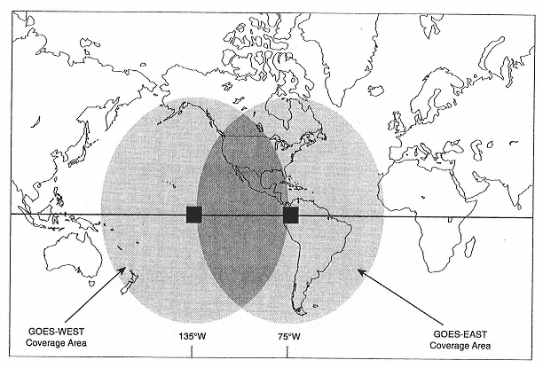
TABLE 2-5 SMS and GOES Series Satellites Launched through 1995
|
Namea |
Launch Dateb |
End of Useful Lifec |
Featuresd |
|
SMS-1e |
17 May 74 |
29 Jan 81 |
|
|
SMS-2 |
6 Feb 75 |
5 Aug 81 |
same |
|
GOES-1 |
16 Oct 75 |
3 Feb 85 |
same |
|
GOES-2 |
16 Jun 77 |
26 Jan 79 |
same |
|
GOES-3 |
15 Jun 78 |
5 Mar 81 |
same |
|
GOES-4 |
9 Sep 80 |
26 Nov 82 |
VAS,i GOES DCS, WEFAX |
|
GOES-5 |
22 May 81 |
30 Jul 84 |
same |
|
GOES-6 |
28 Apr 83 |
21 Jan 89 |
same |
|
GOES-G |
3 May 86 |
launch failure |
|
|
GOES-7 |
26 Feb 87 |
standby |
same |
|
GOES-8 |
13 Apr 94 |
operational |
GOES-I-M imager and sounder, DCS, WEFAX |
|
GOES-9 |
23 May 95 |
operational |
same |
|
a See footnote 4 on page 13 for the convention used in naming satellites. b All spacecraft placed in geostationary orbit. When at least two spacecraft are operational, one is usually located over the Pacific Ocean at about 135 degrees west longitude and the other at about 75 degrees west longitude (see Figure 2-1). When only one spacecraft has been operational, it is usually moved to about 98 degrees to 112 degrees west longitude. c Various sensors and other units may have degraded or failed before the satellite was turned off. d Primary sensors of high priority in the current modernization of the NWS, that is, imagers and atmospheric sounders (see p. 9) plus data collection and relay. e SMS-1 and SMS-2, the prototypes of this new series of satellites, were funded, named, and operated by NASA. The subsequent operational satellites were funded and named by NOAA. f Visible infrared spin scan radiometer, for day and night imaging. g Geostationary operational environmental satellite data collection system h Weather facsimile (for relay of weather maps and satellite images). i Visible infrared spin scan radiometer atmospheric sounder (developed by NASA). j First of the completely new design, GOES-Next, with three-axis stabilization and new sensors for imaging and obtaining soundings of the atmosphere. |
|||
an operational system for meteorology. NASA developed the new spacecraft system and built two prototypes, called synchronous meteorological satellites, SMS-1 and SMS-2. They were launched in May 1974 and February 1975. Three identical operational versions funded by NOAA, GOES-1, -2, and -3, were launched in October 1975, June 1977, and June 1978 (see Table 2–5). The primary sensor on all five satellites was the visible infrared spin scan radiometer (VISSR). The addition of an infrared channel permitted imaging 24 hours a day. The resolution of the visible channel was 1 km at the satellite subpoint; for the infrared, it was 7 km at the subpoint. Also included was an SEM, the GOES data collection system for gathering and relaying environmental data from remote data platforms, and the WEFAX broadcast service for transmitting processed satellite images and weather maps that could be received by anyone with relatively inexpensive equipment.
Five additional GOES spacecraft were procured to continue geostationary coverage during the 1980s. Four, GOES-4 through GOES-7, were launched from September 1980 to February 1987; however, the fifth, GOES-G, suffered a launch failure in May 1986. The main difference in the sensors on these satellites from the earlier GOES series was the use of 12 infrared channels to obtain soundings of the temperature and humidity of the atmosphere, in addition to imaging the clouds and the Earth's surface. This new sensor was called the VISSR atmospheric sounder. However, images and soundings could not be obtained at the same time. Since the highest operational priority was given to tracking severe weather using geostationary satellite images, the soundings were obtained only on an experimental basis. (The NWS relied on the NOAA series of polar-orbiting satellites for soundings from areas of the Earth where sounding data from surface-based or other systems were limited or not available.)
The GOES spacecraft are normally operated in pairs: one is located at about 75 degrees west longitude, and the other at about 135 degrees. Together they provide coverage of the United States and adjacent oceans. When only one spacecraft was operational, it was positioned at about 100 degrees west, which limited or eliminated coverage of Hawaii and much of the Pacific and Atlantic oceans. Insufficient coverage of these areas is of particular concern during the hurricane season. Extended periods of such limited coverage occurred during July 1984 to March 1987 and January 1989 to February 1993, when only one GOES spacecraft was in operation. The single remaining GOES spacecraft was moved to 98 degrees west longitude during the summer-fall period to enhance coverage of hurricanes in the Atlantic Ocean. In the winter it was moved to 108 degrees west longitude to optimize coverage of storms over the Pacific Ocean.
Five spacecraft, GOES-I through GOES-M, were ordered in the GOES-Next series. The first two, now called GOES-8 and GOES-9, were launched in April 1994 and May 1995, and are currently in operation. GOES-K is scheduled for launch in April 1997. The two remaining spacecraft are in various stages of construction (see Chapter 4).
The design of the GOES-Next spacecraft represents a major step forward from the previous GOES. Most important for the NWS is the use of separate imagers and sounders (so both can operate at the same time) with much higher temporal and spatial resolution, more channels, and more precise measurements than the earlier GOES. The new three-axis stabilization (which replaces the older spinning spacecraft) increases the effective sensitivity of the sensors. Also, the navigational accuracy has been improved, which permits more rapid geographical location of data.


