
A WAVE-DRIVEN REFRIGERATOR
The very existence of the noctilucent clouds described earlier reveals a fascinating aspect of the Earth's upper atmosphere, which can be understood only by including the effects of internal waves. First, we reiterate the surprising fact that the summer polar atmosphere is truly the coldest place on Earth, with reported temperatures sometimes less than 100 K (-173 degrees Celsius). A scatter plot illustrating this compares rocket-borne temperature measurements in winter and summer over Norway in Figure 17 .
The summer mesosphere is really cold. Most of the air we breathe is nitrogen, which turns to liquid at 77 K. The stark difference between north and south is evident. The summer atmosphere is 100 K colder than in the winter, even though the sun shines on this region of the sky virtually continuously in summer and hardly at all in winter! How does this happen?
This refrigeration process is now thought to be driven by the transport of momentum from the lower atmosphere to the upper atmosphere by exactly those waves of interest here, waves that propagate upward from the dense lower atmosphere, grow in amplitude, and eventually break in the mesosphere much like a water wave on a beach. This analogy with a water wave is actually quite illuminating.
Swimmers are often warned about rapid longshore currents, which can sweep them parallel to the shore very rapidly. The direction of the current is the same as the projected direction of incoming waves parallel to the shore ( Figure 18 ). Most of the momentum and energy of the waves is dissipated in the turbulence and froth of the breaking waves, but a fraction is converted into an average velocity of the water along the shore. The swimmer is carried along with it, as is some of the sand. This river
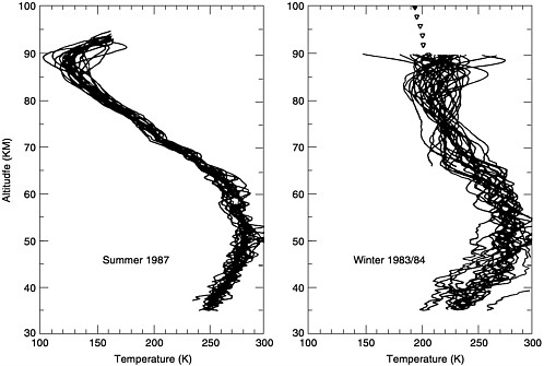
FIGURE 17 Profiles of atmospheric temperature measured by using small rockets launched over Norway. Reproduced from von Zahn and Meyer (1989) with permission of the American Geophysical Union.
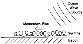
FIGURE 18 Ocean waves breaking in the surf line can deposit momentum in the region and drive a net current down the beach.
of sand shapes the beaches and sand spits all over the world. It is remarkable that distant storms can shape the beaches and move objects in the surf line hundreds of miles away simply through the waves they generate.
However, this is the same type of process that drives the circulation pattern of the Earth's mesosphere, a transport of momentum by waves generated in one portion of the atmosphere and absorbed in another. On average, however, one would expect that these waves would have no preferred direction; hence, it is not obvious that any net momentum would be transferred to the upper atmosphere. This objection is resolved by noting that atmospheric wave dynamics have yet another curious aspect that requires a brief explanation of the Doppler shift phenomenon. Most people have experienced the change in tone of an ambulance siren as it first approaches, then recedes from, the observer, the high pitch gradually descending to a low one. This phenomenon is due to the Doppler effect, a shift in frequency due to relative motion. Recall now the earlier discussion concerning waves observed from a moving boat. On the boat, the waves stand still; they are Doppler shifted to zero frequency, moving with the source. Now suppose an internal wave is launched from a thunderstorm or a cold front. It will have some velocity with respect to the Earth, but if the wind speed at the same higher altitude is in the same direction as the wave, as far as air parcels are concerned, the wave will be Doppler shifted to lower frequency. If at some height the wind speed exactly equals the wave speed, the wave is Doppler shifted to zero and it simply vanishes like the smile on the Cheshire cat.
When a gravity wave propagates upward into the jet stream, the local fluid perceives it at a Doppler-shifted frequency, lower if the wave travels in the same direction and higher if the two velocities are opposite. If the Doppler shift is so severe that the wave becomes stationary in the wind frame, the wave merely becomes part of the flow and is absorbed in it. The oppositely directed waves simply go through into the mesosphere. The result is a directional filter that, when the waves break as they must, results in a net momentum source in the upper atmosphere ( Figure 19 ). Just like the sand in the surf line, the mesosphere is pushed around by distant storms.
Because of the dominant east-west (zonal) character of the jet stream in the Earth's stratosphere, this momentum source operates in the zonal (east-west) direction and causes the summer upper stratosphere and mesosphere to spin up relative to the rotating planet and the winter region to spin down. This additional angular momentum source is compensated by an equatorward shift of the fluid in the summer and a poleward shift in the winter. Such a shift is in turn accompanied by an upwelling in the center of the summer vortex and a downward motion in the winter. The upwelling is a source of adiabatic cooling, whereas the downward flow heats the mesosphere, thus creating a 100 K temperature difference and incredibly cold temperatures in the summer, a wave-driven refrigerator.
This process leads to the production of the noctilucent clouds illustrated earlier. Remarkably, no such clouds were reported before 1885 and they seem to be forming much more often throughout this
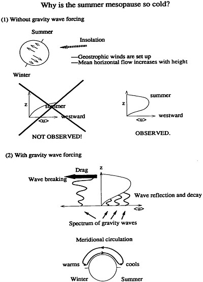
FIGURE 19 The jet stream absorbs waves in one direction but allows them to pass in the opposite. This creates a net momentum source for atmospheric layers above it. Reproduced courtesy of John Cho, Department of Earth, Atmospheric, and Planetary Sciences, Massachusetts Institute of Technology.
century. Two theories have been proffered for this increasing cloudiness, both involving global atmospheric change. One is that methane (CH 4) is increasing the amount of hydrogen available to form water vapor and, eventually, ice for the ice clouds. The primary human source of methane is agriculture. The second idea is that as the lower thermosphere warms up (global warming), the upper atmosphere cools. Both processes may be contributing to the increasing cloudiness (Thomas, 1996), and a lively debate is under way concerning these two possibilities. In either case, the whole topic is likely to remain an interesting one for years to come.


