
called in the Marines—in particular, the 24th Marine Expeditionary Unit and its expert team for Tactical Recovery of Aircraft Personnel, or TRAP. Within 4 hours, the search and rescue team had lifted off from the USS Kearsarge in the Adriatic Sea and headed toward Bosnia. By 6:50 a.m., they had picked up O'Grady in a dramatic textbook rescue, had weathered Serbian small-arms fire, and were heading back home. Later that day in Alexandria, Virginia, William O'Grady, the young flier's father, was informed that his son was alive and safe.
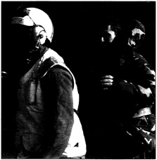
American F-16 pilot Captain Scott F. O'Grady arrives on the deck of the USS Kearsarge in the Adriatic Sea after his June 1995 rescue from Serb-controlled territory in Bosnia-Herzegovina. A GPS receiver concealed in his life vest enabled Marines to pinpoint the downed pilot's location, leading to a successful rescue operation. (AP/Wide World Photos)
The press would hail O'Grady as a hero, and O'Grady himself would give credit and thanks to the Marines who “risked their lives to get me out.” But another factor allowed the Marines to perform their crucial role in the rescue operation with surgical precision. When O'Grady had gone down, his life vest contained a portable radio receiver tuned in to a network of 24 satellites known as the Global Positioning System (GPS). O'Grady was able to determine his position behind enemy lines—longitude, latitude, and altitude—to within a few hundred feet, and he was then able to signal that position to the Air Force fliers overhead and to the Marines who were sent in to rescue him. One cannot help wondering whether O'Grady and his rescuers knew that the technology that made this remarkable rescue possible had grown out of basic research on the fundamental properties of atoms and nuclei some 60 years earlier.
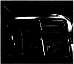
Originally conceived as a navigational tool for the military, the Global Positioning System has spawned many commercial applications in an industry that some predict will reach $30 billion in annual revenues in the next decade: here, a built-in locator device for automobiles. (Trimble Navigation Ltd.)
Time and Location, Precisely
GPS technology makes it possible to answer the simple question “Where am I?” almost instantaneously and with breathtaking precision. The new technology is based on atomic clocks that keep time to within a billionth of a second. They were created by scientists who had no idea that the clocks would someday lead to a global system of navigation. The system made its public debut to rave reviews in the 1991 Gulf War. U.S. troops used it for navigation on land, sea, and in the air, for targeting of bombs, and for on-board missile guidance. GPS allowed U.S. ground troops to move swiftly and accurately through the vast, featureless desert of the Arabian Peninsula.
GPS technology makes it possible to answer the simple question “Where am I?” almost instantaneously and with breathtaking precision. The new technology is based on atomic clocks that keep time to within a billionth of a second. They were created by scientists who had no idea that the clocks would someday lead to a global system of navigation.
Since then, GPS technology has moved into the civilian sector. Today, GPS is saving lives, helping society in many other ways, and generating jobs in a new multi-billion-dollar industry. Advances in integrated-circuit technology—the technology used to make computer chips—soon will lead to GPS receivers and transmitters the size of credit cards, so small and so inexpensive that virtually any vehicle can have one installed and any person can carry one.
In just a few short years, applications for GPS already have become almost limitless:
-
Emergency vehicles use GPS to pinpoint destinations and map their routes.
-
GPS is used to locate vessels lost at sea.
-
Trucking and transportation services use GPS to keep track of their fleets and to speed deliveries.
-
Shipping companies equip their tankers and freighters with GPS for navigation and to record and control the movement of their vessels.

